Residential Development Brief LAND NORTH OF UNION LANE, …
11
Residential Development Brief LAND NORTH OF UNION LANE, OULTON Policy WLP2.14 of the East Suffolk Council Waveney Local Plan Adopted September 2021
Transcript of Residential Development Brief LAND NORTH OF UNION LANE, …

Residential Development Brief
LAND NORTH OF UNION LANE, OULTON Policy WLP2.14 of the East Suffolk Council Waveney Local Plan
Adopted September 2021


Land North of Union Lane, Oulton | Residential Development Brief | September 2021
www.eastsuffolk.gov.uk/planningpolicy 3
1 Introduction The purpose of this brief is to provide a framework for the development of Land North of Union Lane, Oulton (Policy WLP2.14).
1.1 The site has been allocated for approximately 150 dwellings in the East Suffolk Council Waveney Local Plan. The principle of development on this site has therefore already been established, and this document sets out site-specific principles to guide development proposals and allow the site to proceed straight to a full application. This will help ensure that development on the site is appropriately designed in a comprehensive manner whilst meeting the aspirations and needs of both the local community and the Local Plan, in advance of a planning application being submitted for the whole site. This document should not be viewed as an alternative to the pre-application advice service
1.2 It has been prepared by East Suffolk Council. The landowner, Suffolk County Council and Oulton Parish Council were also engaged.
1.3 As a Supplementary Planning Document (SPD) it should be read in conjunction with the adopted Waveney Local Plan which forms part of the development plan for East Suffolk.
1.4 The brief has been prepared with a thorough examination of available evidence. However, further detail may come to light in the future, perhaps as part of assessments that support a planning application. It may be the case that such future evidence warrants a different approach to that proposed in this brief.
1.6 All applications will need to be supported by relevant documents and supporting evidence as required by the East Suffolk Local Validation Requirements.
1.8 The site is within Community Infrastructure Levy (CIL) Residential Charging Zone 3 for the former Waveney area. Therefore, a financial contribution of £89.20 (as of 1st March 2021) will be required per square metre of residential development. The levy will be used to deliver infrastructure to support new development in East Suffolk.
1.9 The site is within the Suffolk Coast Recreational Disturbance Avoidance and Mitigation Strategy (RAMS) Zone of Influence B and therefore, as the proposal creates new residential development, a financial contribution to the scheme (or equivalent mitigation identified via a Habitats Regulations Assessment (HRA)) of £321.22 per new dwelling is required in order to mitigate in-combination recreational disturbance impacts on European designated sites as identified through the Local Plan. A list of other requirements that may be necessary for some sites to mitigate their impact are included in Annex 1 of the draft HRA template.
1.10 Policy WLP8.3 requires sites over 100 units to provide 5% of plots for self or custom build homes as a minimum. There is significant demand for these types of plots and currently there are in excess of 500 people on East Suffolk’s self and custom build register. The Council can offer help in contacting people on the register about self or custom build opportunities. To maximise the benefits from self or custom build homes it is important to consider matters such as their location and any design principles to guide the development from an early stage. To discuss self-build further please email [email protected].
Pre-application advice service
The Council encourages pre-application discussions with planning officers for all applications to ensure the process is as efficient as possible.
Pre-application engagement should be undertaken with key stakeholders, such as Suffolk County Council (highways, flooding etc.), the Environment Agency, Natural England and Historic England.
Contact the Development Management Team to find out about the pre-application advice service and planning application process:
www.eastsuffolk.gov.uk/pre-application-advice-service
Contact details
For further information or queries regarding the planning policy context for this site, please contact the Planning Policy and Delivery Team:
01502 523029 or 01394 444557

Land North of Union Lane, Oulton | Residential Development Brief | September 2021
www.eastsuffolk.gov.uk/planningpolicy 4
South west border of site, looking north West
Centre of Southern border of site, looking North Eastern border of site, looking south
Eastern border of site, looking west
Land North of Union Lane, Oulton | Residential Development Brief | September 2021
www.eastsuffolk.gov.uk/planningpolicy 5
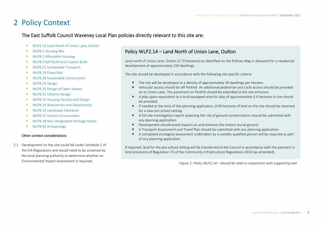
2 Policy ContextThe East Suffolk Council Waveney Local Plan policies directly relevant to this site are:
WLP2.14 Land North of Union Lane, Oulton WLP8.1 Housing Mix WLP8.2 Affordable Housing WLP8.3 Self Build and Custom Build WLP8.21 Sustainable Transport WLP8.24 Flood Risk WLP8.28 Sustainable Construction WLP8.29 Design WLP8.30 Design of Open Spaces WLP8.31 Lifetime Design WLP8.32 Housing Density and Design WLP8.34 Biodiversity and Geodiversity WLP8.35 Landscape Character WLP8.37 Historic Environment WLP8.38 Non-Designated Heritage Assets WLP8.40 Archaeology
Other context considerations
2.1 Development on the site could fall under Schedule 2 of the EIA Regulations and would need to be screened by the local planning authority to determine whether an Environmental Impact Assessment is required.
Policy WLP2.14 – Land North of Union Lane, Oulton
Land north of Union Lane, Oulton (5.70 hectares) as identified on the Policies Map is allocated for a residential development of approximately 150 dwellings.
The site should be developed in accordance with the following site specific criteria:
The site will be developed at a density of approximately 30 dwellings per hectare. Vehicular access should be off Parkhill. An additional pedestrian and cycle access should be provided
on to Union Lane. The pavement on Parkhill should be extended to the site entrance. A play space equivalent to a local equipped area for play of approximately 0.4 hectares in size should
be provided. If needed at the time of the planning application, 0.09 hectares of land on the site should be reserved
for a new pre-school setting. A full site investigation report assessing the risk of ground contamination should be submitted with
any planning application. Development should avoid impacts on and enhance the historic burial ground. A Transport Assessment and Travel Plan should be submitted with any planning application. A completed ecological assessment undertaken by a suitably qualified person will be required as part
of any planning application.
If required, land for the pre-school setting will be transferred to the Council in accordance with the payment in kind provisions of Regulation 73 of the Community Infrastructure Regulations 2010 (as amended).
Figure 1: Policy WLP2.14 – should be read in conjunction with supporting text

Land North of Union Lane, Oulton | Residential Development Brief | September 2021
www.eastsuffolk.gov.uk/planningpolicy 6
3 Development ConsiderationsThis section outlines what currently exists on and around the site in terms of the built, natural and historic environments which will need to be considered by any proposal as outlined in the Development Framework (Section 4). Understanding the place
3.1 The site lies on the edge of Oulton, with agricultural fields to the north and west. The land slopes down towards the western edge, then slopes back up beyond site boundary.
3.2 Key countryside views are identified across the site towards the north and west.
3.3 Residential development bounds the site to the south and east (along the B1375). A care home is located within the residential area to the south.
3.4 A number or derelict buildings are located within the western extent of the site.
3.5 The immediate built environment comprises a mix of one, two and three storey dwellings of a semi-detached and detached nature. Single storey dwellings can be found adjacent to the site along Airey Close.
3.6 Surrounding dwellings generally front onto their associated streets rather than onto the site.
3.7 The massing of surrounding buildings is commensurate with their use, with residential dwellings showing a range of masses and densities.
Figure 2: Development density, building heights and key views
3.8 There are limited public open spaces between buildings, the most significant area is situated between the dwellings of Airey Close and the care home.
3.9 The foul sewerage network will require improvements to support new development.
3.10 Telephone lines are located on the west side of the B1375 close to the boundary of the site.

Land North of Union Lane, Oulton | Residential Development Brief | September 2021
www.eastsuffolk.gov.uk/planningpolicy 7
Figure 3: Natural and historic features within the site and wider environment
Natural and historic environment3.11 The site is located within an area of low landscape
capacity, as identified in the Great Yarmouth and Waveney Settlement Fringe Landscape Sensitivity Study (2016).
3.12 Workhouse Wood, Parkhill Wood, Flixton Decoy, Flixton Decoy Meadows, Whitehouse Farm Meadow, Blundeston Prison Lake and Woods and Foxborough Wood County Wildlife Sites are all located within 1km of the site.
3.13 The Landscape Character Assessment states that small farm woodlands and small-scale intricate field patterns highlight the historic enclosure landscape pattern. The wooded skylines associated to the tributary valleys and woodland blocks are judged sensitive, as are field boundary networks, which provide a sense of enclosure.
3.14 There are a number of large freestanding trees located on the site, none of which are protected by Tree Preservation Orders (TPO).
3.15 Two Grade II listed buildings are located 15 metres east of the site on the opposite side to the B1375. The buildings and their settings are statutorily protected. The principal elevations of the listed buildings face the site - any proposal must take full account of their setting in terms of potential impacts on significance.
3.16 The site was formerly used as a hospital and a workhouse, with an associated burial site located in the north west corner of the site. There are sewage filter beds in the western part of the site and cropmarks to the north, west and south west.
3.17 The Suffolk County Council Historic Environment Record shows World War II defensive ditches run within the allocation area.
3.18 There are potential issues with land contamination due to its previous use as Lothingland Hospital. A full site investigation report should be submitted with any planning application which includes reports on intrusive surveys, a risk assessment and remediation method statement.
3.19 Shallow groundwater has been encountered nearby which could affect the feasible depth of Sustainable Drainage Systems (SuDS).

Land North of Union Lane, Oulton | Residential Development Brief | September 2021
www.eastsuffolk.gov.uk/planningpolicy 8
Movement 3.20 Footpaths are located close to the south western
and northern boundaries of the site, Footpath 6 and Footpath 3 respectively.
3.21 There is no footway along Parkhill and adjacent residential roads have unconnected footways.
3.22 There is no cycle infrastructure directly connecting to the site.
3.23 The nearest bus stops are located approximately 0.3 miles south and 0.5 miles north of the site along Parkhill (B1375).
3.24 Oulton Broad North train station is located 1.5 miles to the south.
The following facilities and services are located nearby (as shown in Figure 4):
Oulton Community Centre – including
recreation ground (0.2 miles to the south).
Crestview Medical Centre (0.8 miles to the south east)
Aldi Grocery Shop (0.6 miles to the east).
Oulton Post Office (1 mile to the south).
Woods Loke Primary School (1 mile to the south east)
The Limes Primary Academy (1 mile to the south west)
The Benjamin Britten Music Academy (1.1 miles to the east)
Figure 4: Connectivity to services and facilities

Land North of Union Lane, Oulton | Residential Development Brief | September 2021
www.eastsuffolk.gov.uk/planningpolicy 9
4 Development FrameworkThis section highlights what will be expected from proposals in response to the development considerations raised in the previous section. The following design principles are displayed in Figure 5 (Development Framework Map).
Creating a built form 4.1 Development should create a strong built edge
fronting onto both Parkhill and the western boundary, overlooking the proposed cycling and walking routes.
4.2 The main access road off Parkhill should be linear, creating an attractive principal route through the development with high quality landscaping. The route should be tree lined and maximise the key view through to the countryside beyond.
4.3 Street patterns and building frontages should retain and frame key views on and beyond the site.
4.4 Any continuation of development along the western edge should ensure key views are retained and the historic significance of the burial site is preserved.
4.5 Development must be appropriately set back from the single storey dwellings along the southern edge of the site, retaining existing vegetation where possible.
4.6 All open space should be carefully enclosed and overlooked to provide natural surveillance.
4.7 The local equipped area for play should be delivered whilst making the most of key views.
4.8 The infrastructure requirements included in this brief, such as the play space and pre-school, should not be considered exhaustive. Further infrastructure requirements may be identified as necessary to deliver development as the site progresses through the planning process.
Landscape and heritage integration
4.9 Existing hedgerows along the boundaries of the site and freestanding trees should be retained and enhanced. Development should be appropriately set back from root protection areas.
4.10 Except where needed for access, the hedgerow along Parkhill should be retained as it is important in helping to preserve the settings of the two listed buildings located to the east as well as for its biodiversity value.
4.11 A wildlife corridor should be incorporated from the north to the south of the site alongside the existing vegetation.
4.12 Native planting should be used to integrate the site with the landscape structure.
4.13 Development will be supported where it will retain, restore and enhance the biodiversity of the site. Development should achieve demonstratable net gains for wildlife, habitats and green infrastructure improvements.
4.14 A minimum of 12-15% of the site should be reserved for strategic, above ground, open Sustainable Drainage Systems (SuDS) (i.e. not including pervious surfaces) until a more detailed analysis of surface water drainage requirements is undertaken.
4.15 National mapping suggests infiltration may not be feasible in parts of the site. Testing will be required to investigate this further. If infiltration is achieved this must be prioritised at source. Consideration must be given to groundwater levels and the location of the site in a Source Protection Zone. The applicant must engage with SCC to ensure appropriate SuDS are incorporated. Existing watercourses must be integrated into the development layout.
4.16 An application must be supported by results of a programme of archaeological evaluation so the history of the site, including the defensive ditches, the burial ground and the workhouse lands are fully understood.
4.17 This should include desk-based assessment, heritage asset assessment, visual impact assessment and appropriate fieldwork, and should demonstrate the impacts of development on archaeological remains and proposals for managing those impacts.
4.18 Development on the burial ground should be avoided and be designed to preserve and enhance its historic significance and setting. This could include using open space to protect the integrity of the burial site and measures that assist in the interpretation of the heritage aspects of the site.

Land North of Union Lane, Oulton | Residential Development Brief | September 2021
www.eastsuffolk.gov.uk/planningpolicy 10
Streets and movement
4.19 Cycling and walking connections should be made onto Union Lane
4.20 Pedestrian and cycle connections should be made between Footpath 3 and Footpath 6 along and beyond the western boundary of the site. The site should be connected to Policy WLP2.15 for walking and cycling via Footpath 6, which should be upgraded to a bridleway.
4.21 Cycling and walking infrastructure should be provided along Parkhill, west of the existing hedgerow, linking north into Footpath 9. A footway should be provided along Parkhill, to the crossroads at Union Lane.
4.22 Discussions must be held with SCC to determine the appropriate form for the junction from Parkhill - based on the traffic flows associated with the development and Parkhill as well as consideration of pedestrians and cyclists.
Figure 5: Development framework map

Land North of Union Lane, Oulton | Residential Development Brief | September 2021
www.eastsuffolk.gov.uk/planningpolicy 11
www.eastsuffolk.gov.uk/planningpolicy
Email us
Call us
01502 523029 or 01394 444557
Write to us
East Suffolk Council Planning Policy and Delivery Team
Riverside, 4 Canning Road, Lowestoft Suffolk NR33 0EQ
This document is available in alternative formats and in different languages on request. If you need support or assistance to help you read and/or understand this document, please contact the Council using one of the methods above.


![Residential Property - OnTheMarket...Residential Property 23 Church Lane Wicklewood Wymondham NR18 9QH Offers in Excess Of £325,000 twgaze.co.uk [Type text] twgaze.co.uk Location](https://static.fdocuments.us/doc/165x107/5fd91c73b8ae734c49580403/residential-property-onthemarket-residential-property-23-church-lane-wicklewood.jpg)