
Plymouth, IN Comprehensive Plan
168
PLYMOUTH COMPREHENSIVE PLAN ADOPTED JUNE 24, 2013
-
Upload
ratio-community-collaborate -
Category
Documents
-
view
216 -
download
1
description
Â
Transcript of Plymouth, IN Comprehensive Plan

PLYMOUTH COMPREHENSIVE PLAN
ADOPTED JUNE 24, 2013


ADOPTED: JUNE 24, 2013
COmPrEhENsivE PlAN
CiTy Of PlymOUTh , iNDiANA
City of Plymouth


3 City of Plymouth
IntroductIon 1
JUNE 2013
fOrEwOrD
In 2003 the City of Plymouth updated their Comprehensive Plan to effectively manage a growing community. The community has now arrived at a time when slow growth and a changing economy demands an up-to-date Comprehensive Plan to guide local decision-making in an effort to ensure the greatest return on public and private investment. In addition, other plans have since been completed including the Downtown Strategic Plan and the Plan for Downtown which addressed strategic investments, urban design and the 2011 River Park Square Plan.
Utilizing a committee of involved citizens and city staff, coupled with opportunities for public input, the 2013 update revisited the 2003 objectives and strategies to test their validity and relevancy.
As community decisions are made, the Comprehensive Plan should be consulted as the primary policy guide. Decisions should be considered based not on their relationship to a single goal or policy, but on how they fit in with the entire framework of the plan.
An important addition in 2013 is an implementation table included in Chapter 14 which can serve as a foundation for a Capital Improvement or Redevelopment Plan and will function as a checklist during annual review to ensure that the vision and policies remain relevant and strategies initiated are completed.

4Comprehensive Plan
IntroductIon1 visiON sTATEmENT
In 2013, as our community gathered to write this comprehensive plan, we celebrate 140 years of Plymouth as a city. We’ve come a long way since 1873. But, at the same time, we maintain the spirit of our founding fathers and the ingenuity and adaptability that characterizes us as Hoosiers. As we reach this milestone and as Indiana nears its bicentennial, Plymouth continues to be a great place to live and work and, with planning, the City is poised to take on an enhanced role in our region and our state. In this plan we set forth the following vision for our future:
Community Character & Identity
Enhancement of the small town character of Plymouth, attractive signage and gateways that welcome visitors to the community, and high quality design of new growth.
High Quality Public Services
A strategic plan for management of public utilities, continued improvements to the parks and recreation system, and strong police and fire services.
Strong Neighborhoods
Safe, clean and well-maintained properties, connected to each other and the broader community, with a variety of housing options to serve our diverse population. Neighborhoods that make Plymouth shine as a brighter spot on the map.
A Strong Economic Foundation
Fostering growth in our existing businesses and industries and creating conditions for positive economic development and new business attraction.
A Vibrant Downtown
Continuing to enhance the area with a mix of shops, restaurants, and other uses that draw people downtown, and capitalize on our ongoing revitalization efforts, the Yellow River, and our natural environment.
A Safe & Efficient Transportation System
Roadways that are well planned and connected, accessible sidewalks and greenways trails that extend throughout the City, and an effective system of routes for truck traffic.
It is never easy to predict what might come tomorrow, next month, or the next decade, but planning gives us a chance to stay on the right path. The author William Arthur Ward once said, “The pessimist complains about the wind, the optimist expects it to change, the realist adjusts the sails.” In 1873, our forefathers adjusted the sails and 140 years later we continue to chart a course toward success for this beautiful city.
- Mayor Mark Senter

5 City of Plymouth
IntroductIon 1
JUNE 2013
Foreword 3Vision Statement 4Contents 5Acknowledgments 6
Chapter 1 - Introduction 7Comprehensive Plan Mandate 8How To Use This Document 9Sustainable Policies 9Public Input Process 10
Chapter 2 - Community Profile 11Setting 12Demographics Overview 14History 16Planning Principles 19
Section i - GoalS and action StepS
Chapter 3 - Character & Identity 21Goals 22Profile: Gateways & Wayfinding 25
Chapter 4 - Land Use & Growth Management 29Goals 31Profile: Annexation 32Profile: Fiscal Impact Analysis 34
Chapter 5 - Housing & Neighborhoods Goals 40Profile: Neigborhood Conservation Dist. 42Profile: Andrews University Plan 44Profile: Housing Diversity 47
Chapter 6 - Downtown 51Profile: Historic Railroad Depots 53Goals 54Profile: Walkable Communities 55
Chapter 7 - Economic Development 59Goals 61Profile; Redevelopment Commissions Recommendations: Ady Voltedge Plan 66
Chapter 8 - Parks, Recreation & Open Space 67Goals 69Profile: BMP’s For Stormwater 70Profile: Wetlands 74Profile: Riparian Areas 75Profile: Urban Forestry 77
TAblE Of CONTENTs
Chapter 9 - Public Services & Infrastructure 79Goals 81Profile: Addressing Failing Septic Sys. 82Profile: Capital Improvement Plan 85
Chapter 10 - Transportation Goals 89Profile: Access Management 90Profile: Roundabouts 94Profile: Walkable Communities 96Profile: ADA 98
Section ii - implementation
Chapter 11 - Land Use PlanFuture Land Use Map 99Land Use Descriptions 100
Chapter 12 - Focus Area ConceptsFocus Areas Map 109Focus Area 1 110Focus Area 2 112Focus Area 3 114Focus Area “Crossroads Corridor” 116
Chapter 13 - Thoroughfare Plan 119Thoroughfare Classifications 121Thoroughfare Plan Map 122Multi-Modal Map 127
Chapter 14 - Implementation Tools 129Organizational Structure 130Implementation Matrix 131
Section iii - SupportinG data
Chapter 15 - Appendix 149A. Meeting Summary’s 150B. Demographic Analysis 160
city of plymouth comprehenSive plan
39
87
97
107
61

6Comprehensive Plan
IntroductIon1 ACkNOwlEDgmENTs
The City of Plymouth is to be applauded for taking the initiative to update and create this action oriented 2013 Plymouth Comprehensive Plan. This Plan update will serve as a guide for community decision makers five, ten and up to fifteen years into the future. Special thanks to the steering committee and the people of Plymouth, particularly those who attended the workshops, completed the surveys, participated in the interviews.
Comprehensive Plan Steering CommitteeMayor Mark SenterSean SurrisiShawn GrobeKeith HammondsJeff HouinJennifer LaurentDerek SpierJim MarquardtPhil BockmanRalph BookerDonnie DavidsonRick GaulMark GidleyBrent MartinMike MileyDave MorrowDiana NielsenLinda Rippy
RATIO Architects, Inc. Jackie Turner, AICP, LEED APAaron KowalskiBrian Staresnick, LEED APKevin SenningerJennifer Higginbotham, AICP
7 City of Plymouth
IntroductIon 1
JUNE 2013
INTRODUCTION 1

8Comprehensive Plan
IntroductIon1 COmPrEhENsivE PlAN mANDATE
Indiana State Statute (IC 36-7-4-501) provides for a comprehensive plan prepared by each Plan Commission to promote the public health, safety, morals, convenience, order or the general welfare and for the sake of efficiency and economy in the process of development.
Per IC 36-7-4-502, a comprehensive plan must contain:
•a statement of objectives for the future development of the jurisdiction;•a statement of policy for the land use development of the jurisdiction; and•a statement of policy for the development of public ways, public places,
public lands, public structures, and public utilities.
Statute (IC 36-7-4-503) allows the incorporation of additional sections into a plan to address issues and goals specific to the jurisdiction including but not limited to natural features, parks and recreation, economic development and redevelopment opportunities.

9 City of Plymouth
IntroductIon 1
JUNE 2013
hOw TO UsE This DOCUmENT
This plan can best be described as a community guidebook to reference when reviewing development plans, making budgets, or setting priorities in the city limits or the 2-mile Extraterritorial Jurisdiction (ETJ) which the City of Plymouth exercises. The ETJ is often referred to as the “fringe”or “buffer”. Because of its emphasis on public participation this plan gives city leaders the confidence of knowing there is community support and buy-in. This plan:
•Will help guide the Plan Commission and other boards and commissions in the decision-making process,
•Can assist the City Council when considering capital improvements, land use rezoning, or economic development decisions,
•Can assist department heads to qualify their recommendations to the City Council,
•Can provide civic groups with ideas on how to strengthen and enhance the community, and
•Serves as the legal basis for protection and conservation of sensitive environmental and historic areas.
The plan should be reviewed annually by the City Council, Plan Commission and city leaders, municipal department heads, and other community stakeholders to
ensure the plan and its individual elements remain relevant. This document should also be updated every five to ten years in response to land use trends, changes in population, or any major events. To facilitate the decision making process, the document is organized with the following features:
Sustainable Policies
Throughout this Comprehensive Plan, small green leaf ( ) icons have been placed next to policies considered to be environmentally sustainable. They range from easily recognizable indicators, like smoke or water pollution, to more subtle issues that can build over time, like decentralized or sprawling development which can increase the number of and distance per automobile trip which increases emissions.
A Goal directly supports the collective efforts and ideals of the community reflected in the Vision Statement.
Policies
1. A policy provides a variety of avenues or opportunities to achieve the intent of a Goal.
Action Steps » Action Steps are the specific implementation
strategies taken by town officials, business leaders, community organizations, and residents to accomplish the goals.
10Comprehensive Plan
IntroductIon1Recommendations within this plan marked by the leaf symbol may include:
•Encouragement for mixed-use, compact development and redevelopment•Alternative transportation methods to reduce automobile trips and encourage
healthy, walkable lifestyles•Protection of natural resources such as riparian areas, forests, water features,
and air quality•Policies that encourage resource conservation•Coordinated infrastructure decisions that ensure fiscal responsibility
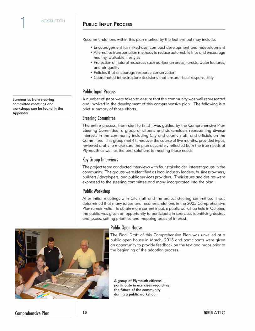
Public Input ProcessA number of steps were taken to ensure that the community was well represented and involved in the development of this comprehensive plan. The following is a brief summary of those efforts.
Steering CommitteeThe entire process, from start to finish, was guided by the Comprehensive Plan Steering Committee, a group or citizens and stakeholders representing diverse interests in the community including City and county staff, and officials on the Committee. This group met 4 times over the course of five months, provided input, reviewed drafts to make sure the plan accurately reflected both the true needs of Plymouth as well as the best solutions to meeting those needs.
Key Group InterviewsThe project team conducted interviews with four stakeholder interest groups in the community. The groups were identified as local industry leaders, business owners, builders / developers, and public services providers. Their issues and desires were expressed to the steering committee and many incorporated into the plan.
Public WorkshopAfter initial meetings with City staff and the project steering committee, it was determined that many issues and recommendations in the 2003 Comprehensive Plan remain valid. To obtain more current input, a public workshop held in October, the public was given an opportunity to participate in exercises identifying desires and issues, setting priorities and mapping areas of interest.
Public Open HouseThe Final Draft of this Comprehensive Plan was unveiled at a public open house in March, 2013 and participants were given an opportunity to provide feedback on the text and maps prior to the beginning of the adoption process.
Summaries from steering committee meetings and workshops can be found in the Appendix
A group of Plymouth citizens participate in exercises regarding the future of the community during a public workshop.
PUbliC iNPUT PrOCEss

City of PlymouthJUNE 2013
COMMUNITY PROFILEPreface 2
12Comprehensive Plan
2 Community Profile
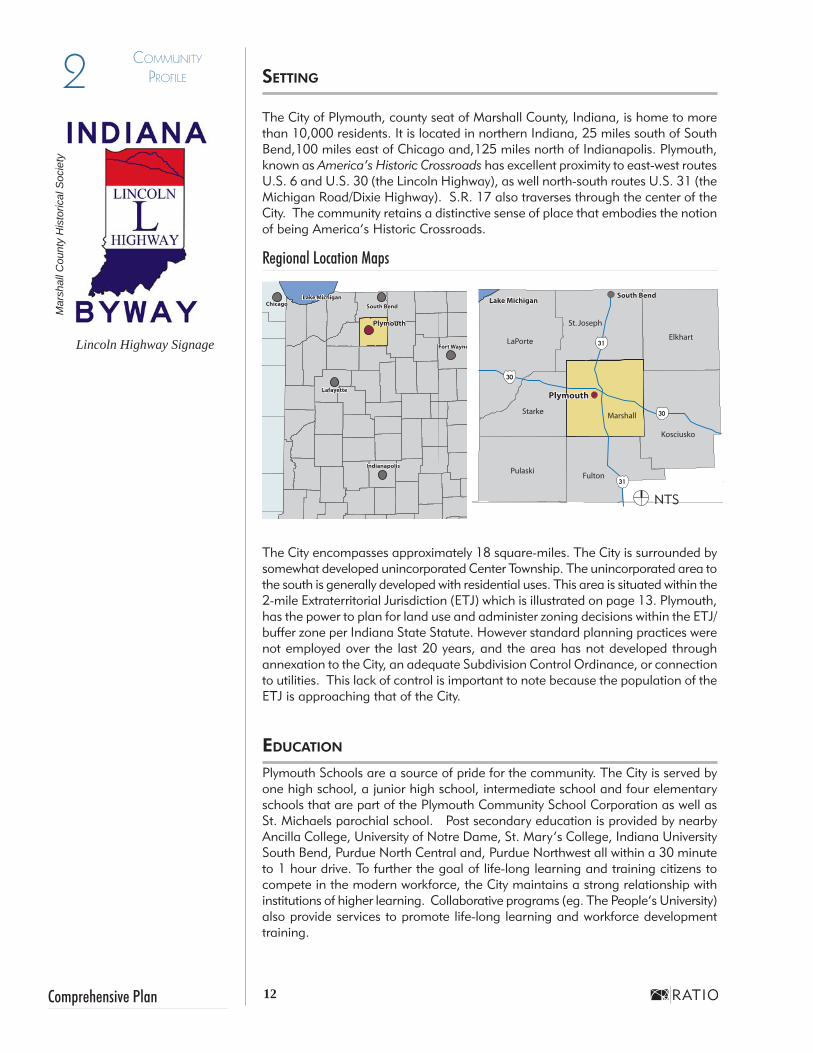
The City of Plymouth, county seat of Marshall County, Indiana, is home to more than 10,000 residents. It is located in northern Indiana, 25 miles south of South Bend,100 miles east of Chicago and,125 miles north of Indianapolis. Plymouth, known as America’s Historic Crossroads has excellent proximity to east-west routes U.S. 6 and U.S. 30 (the Lincoln Highway), as well north-south routes U.S. 31 (the Michigan Road/Dixie Highway). S.R. 17 also traverses through the center of the City. The community retains a distinctive sense of place that embodies the notion of being America’s Historic Crossroads.
Regional Location Maps
The City encompasses approximately 18 square-miles. The City is surrounded by somewhat developed unincorporated Center Township. The unincorporated area to the south is generally developed with residential uses. This area is situated within the 2-mile Extraterritorial Jurisdiction (ETJ) which is illustrated on page 13. Plymouth, has the power to plan for land use and administer zoning decisions within the ETJ/buffer zone per Indiana State Statute. However standard planning practices were not employed over the last 20 years, and the area has not developed through annexation to the City, an adequate Subdivision Control Ordinance, or connection to utilities. This lack of control is important to note because the population of the ETJ is approaching that of the City.
EDUCATiON
Plymouth Schools are a source of pride for the community. The City is served by one high school, a junior high school, intermediate school and four elementary schools that are part of the Plymouth Community School Corporation as well as St. Michaels parochial school. Post secondary education is provided by nearby Ancilla College, University of Notre Dame, St. Mary’s College, Indiana University South Bend, Purdue North Central and, Purdue Northwest all within a 30 minute to 1 hour drive. To further the goal of life-long learning and training citizens to compete in the modern workforce, the City maintains a strong relationship with institutions of higher learning. Collaborative programs (eg. The People’s University) also provide services to promote life-long learning and workforce development training.
sETTiNg
Maps Not
To Scale
Plymouth
IndianapolisIndianapolis
Fort WayneFort Wayne
South BendChicago South BendChicagoChicago
Plymouth
Lake MichiganLake Michigan
LafayetteLafayette
South BendLake Michigan
University of Notre Dame
South Bend
PlymouthPlymouth
Lake Michigan
Mar
shal
l Cou
nty
His
toric
al S
ocie
ty
Lincoln Highway Signage
NTS

13 City of Plymouth
2Community Profile
JUNE 2013
MIC
HIG
AN
ST
NORFOLK SOUTHERN RR
5TH
POTENTIALROUND ABOUT
9A
LINCOLN HWY
PLYMOUTH-GOSHEN TR
FUTURE INTERCHANGE
30
30
31
31
CSX RR
CSX RR
NORFOLK SOUTHERN RR
INDIANA
17
INDIANA
17
INDIANA
17
P:\2012\12074 - Plymouth Comprehensive Plan Update\Document\Drafts\Adoption Draft
MIC
HIG
AN
ST
MICHIGAN RD
MICHIG
AN ST
OA
K R
DLA
KE
AVE 5T
H
OA
K R
D
JEFFERSON STLA PORTE
ST
HOHAM DR
JIM NEU RD
LAKE AVE
HARRISON ST
SKYLANE DR
FUTURE 7A RD
FUTURE 7A RD
9A RD
KIN
G R
D
LINCOLN HWY
PLYMOUTH-GOSHEN TR
PLYMOUTH-GOSHEN TR
12TH RD
GLENN-OVERMYER TR
BAKER STNORTH ST
RA
ND
OLP
H B
LVD
WES
TER
N A
VE
LIB
ERTY
ST
LINCOLN HWYR
ICH
TER
ST
PIO
NEE
R S
TPI
NE
RD
OLI
VE T
R
NU
TMEG
RD
MU
CK
SHAW
RD
CO
RPO
RAT
E LI
MIT
S
EXTR
ATER
RIT
OR
IAL
JUR
ISD
ICTI
ON
BO
UN
DA
RY
COrPOrATE AND ExTrATErriTOriAl JUrisDiCTiON bOUNDAry mAP
LEGENDCorporate Boundary
Extraterritorial Jurisdiction Boundary
NTS

14Comprehensive Plan
2 Community Profile
208
201.02
207.02207.01
203.02
203.01
202.02 202.01
206
201.01
205204
Source: IBRC at Indiana University's Kelley School of Business, using tract boundaries from TIGER 2010 and ArcGIS Online StreetMap. March 2011
Marshall County, Indiana Census Tracts 2010
More detailed demographic information can be found in Appendix: B, Demographics Data.
The City of Plymouth’s population was 10,033 based on the 2010 census. But if you count just 5 census tracts just outside the corporate limits there is nearly double that population (over 19,000). This has a great influence on how Plymouth thrives and survives. It is important to review data not just for incorporated Plymouth but also to include data for Marshall County Census Tracts 203.01, 204, 205, 206, 207.01 shown below. The information presented here was acquired from the 2011 American Community Survey (ACS) data and 2010 U.S. Census Data.
DEmOgrAPhiCs OvErviEw
What a difference a decade makes. Between 1990 and 2000, Plymouth grew 18.5%. By contrast, Plymouth’s 2011(ACS) population estimate of 10,047 represents a 1.9% increase, and is much slower than the State of Indiana rate of 7.2% growth during the same period.
Both the percentage of people under 18 years (27.9%) and people over 65 years of age (15.2%) in Plymouth in 2010 are higher than Indiana’s percentages (24.8% and 13.0% respectively). In addition, Indiana’s average for both of these numbers decreased from 2000, while Plymouth’s percentages for both increased. This indicates that people of typical working age have left Plymouth.
Age Plymouth State Average
Under 18 27.9% 24.8%
65+ 15.2% 13.0%
Plymouth Plymouth Inc. ETJ State Average
Median Income $33,872 $58,416 $48,393
Marshall County Census Tracts
Plymouth is primarily Caucasian (77%) followed by Hispanic/Latino (19%). The Hispanic/Latino population is a higher percentage than the state average of 6.01%, while the population of Black or African American population (0.74%) is much lower than the state average of 8.98%. When Considering the 5 census tracts to the south, the Caucasian population increased to 85% and the Hispanic/Latino population decreased to 12%. Within the City an estimated 21% (ACS) of residents speak a language other than English at home. Within the 5 census tracts% of residents speak a language other than English at home.
While the 2011 American Community Survey shows a slight increase in high school graduates and residents with a bachelor’s degree both categories are more than five points lower than the state’s average (86.6% and 22.7% respectively).
Source: STATS Indiana
3031
3031
3031
3031
Michigan St.
Downtown Plymouth
NTS

15 City of Plymouth
2Community Profile
JUNE 2013
Plymouth’s median household income in 2011 within the corporate limits was $33,872, only 70% of the state’s median income of $48,393. It has slipped since the 2000, census and continued during the 2010, census, while the percentage of people living below the poverty level has grown and remained high in Plymouth, with 19.3% as compared to Indiana’s 14.1%.
DEmOgrAPhiCs OvErviEw (CONT.)
Age Plymouth State Average
Under 18 27.9% 24.8%
65+ 15.2% 13.0%
Plymouth Plymouth Inc. ETJ State Average
Median Income $33,872 $58,416 $48,393
The results vary when the census tracts south of the City are considered. The residents here do not contribute to Plymouth’s property tax base, but can be considered to contribute to the overall economy if they work in or make purchases within the city. Some but not all tracts have a median household income of more than $58,000, fewer than 7% living in poverty and homeownership rates and values exceeding the state averages by more than 20%.
Source: A combination of 2000 & 2010 US Census and Source: 2007-2011 American Community Survey 5-Year Estimates Survey data
As of 2010, there were approximately 8,075 primary jobs within Plymouth. However, the majority of those jobs are held by citizens from outside Plymouth. (6,624). Of the resident working population, only 40% (1,451) of workers hold their primary job within Plymouth. The remaining 60% (2,241) of the resident working population work outside of the community.
Final Snapshot•The City of Plymouth has seen little population growth in 10 years.•Plymouth has more young people (under 18 years) and seniors (over 65
years) than in 2010 and the state average which results in a decrease of the citizens likely to hold jobs.
•Nearly 1/5 of Plymouth’s population is Hispanic/Latino (three times the state average) and nearly the same percentage of people speak a language other than English at home.
•There is only a trace representation of African Americans. •The median household income is 70% of the state’s median. •Residents’ median income has decreased in recent years, yet median home
values have risen, increasing the affordability gap.•Both Plymouth’s percentage of residents graduating high school and earning
degrees are lower than the state average.•Most of Plymouth’s residents commute to work outside of Plymouth,
despite there being twice as many jobs in Plymouth as the resident working population.
Source: The Indiana Department of Workforce Development’s Hoosiers by the Numbers - Local Employment Dynamics (LED) and STATS Indiana.

16Comprehensive Plan
2 Community Profile
Marshall County was once occupied by mound builders who built several mounds and earthworks. The Yellow River, a tributary of the Kankakee River and part of the greater Mississippi River watershed, was an important natural feature of the area. Marshall county contains a number of natural lakes, including Lake Maxinkuckee. The area around what is now Plymouth was occupied the Miami and Potawatomie
Indians in the early nineteenth century.
In 1826, ten years after Indiana was admitted to the Union, a treaty with the Potawatomi gave a strip of land to the U.S. government. The Potawatomie forfeited their claim to Northwest Indiana in the Treaty of Tippecanoe in 1832. This allowed the early settlement of Plymouth, Indiana at the intersection of historic transportation routes. The Michigan Road, a highway connecting Lake Michigan to the Ohio River port of Madison, Indiana, was among the earliest state highways. As automobile use became practical for long-distance travel in the 1910s, a number of highway routes were promoted to connect various parts of the United States. The Lincoln Highway, envisioned as the first trans-continental automobile route, was created through northern Indiana and later
became part of U.S. Route 30. The new Dixie Highway, connecting the major cities of the Midwest with the South and the emerging tourist destinations in Florida, overlapped the old Michigan Road route between South Bend and Indianapolis. Today portions of the Lincoln Highway, Michigan Road and Dixie Highway remain intact. Where they all intersect in Plymouth at Jefferson and Michigan Streets, has long been called the “four corners.”
In 1834, Colonel William Polk, James Blair, and John Sering laid out the town of Plymouth along the Yellow River at the intersection of the Michigan Road and the old La Porte trail. Marshall County was divided out of St. Joseph County in 1836 and Plymouth was selected as the county seat. In 1838 nearly 900 remaining Potawatomi were forcibly removed from the Plymouth area by the U.S. Army and marched to the Indian Territory in Kansas on a route that became known as the Potawatomi Trail of Death.
Plymouth’s population grew to 600 persons by 1851, when the town was incorporated. A massive fire in 1857 destroyed most of the downtown business district but citizens soon rebuilt the area with new brick commercial buildings. Plymouth’s first two railroad connections opened in 1856, followed by additional railroads in 1868 and 1874. These transportation connections opened up wider markets for Marshall County produce and helped spur the growth of Plymouth as the county’s business and residential center. The Marshall County Courthouse (1870-72) was designed by Chicago architect Gordon P. Randall and is the most architecturally
La Porte Street in Downtown Plymouth, c.1925
Mar
shal
l Cou
nty
Inte
rim R
epor
tW
ikim
edia
Com
mon
s
Two- and three-story commercial buildings on Michigan Street
with office and residential space over first-floor retail
hisTOry

17 City of Plymouth
2Community Profile
JUNE 2013
significant structure in the county. Plymouth was incorporated as a city in 1873.
Street lighting was introduced in the late -1870’s with lamps burning coal oil. These were replaced by electric arc street lamps in 1888. The city’s waterworks was also built in 1888. A series of parks were developed along the Yellow River, including Magnetic Park (c.1875), home to the Conservation Clubhouse built by the Works Progress Administration in 1937, and Centennial Park (1916), created to honor the Indiana State Centennial. Plymouth’s urban form was established by the turn of the twentieth century, with a dense urban downtown area along Michigan Street surrounded by residential neighborhoods. The city was home to more than 3,600 persons by 1900.
The State of Indiana built a memorial to Chief Menominee of the Potawatomie near Plymouth in 1909, following passage of a bill introduced by local historian and state representative Daniel McDonald. This was the first memorial honoring a Native American built by any U.S. state. The memorial also signaled a renewed interest in Plymouth’s Native American heritage, leading to the adoption of Native American names for many local groups and institutions.
By 1920, Plymouth had more than 4,300 citizens. In 1926, the landmark catalogue-order firm of Montgomery Ward opened its first-ever retail store in Plymouth, marking the company’s shift to retail stores in addition to mail-order business. The Montgomery Ward Building at 214 N. Michigan Street in downtown Plymouth remains largely intact, with an original sculpted plaque by J. Massey Rhind depicting the “Spirit of Progress.” Within two years, the company was operating 244 retail stores, many housed in new buildings matching the prototype store in Plymouth. Plymouth continued to grow during the mid-twentieth century, reaching a population of 6,700 by 1950. Michigan Street remained the primary commercial hub for the surrounding area but post-World War II suburban sprawl drew some residents and businesses away from the downtown area. Many historic buildings were demolished to satisfy an increasing demand for parking.
Indi
ana
His
toric
al S
ocie
ty
Michigan Street in Downtown Plymouth, c.1910
Indi
ana
Land
mar
ks
The Marshall County Courthouse, completed in 1872
hisTOry (CONT.)

18Comprehensive Plan
2 Community Profile
Plymouth is fortunate to retain many historic structures and features that contribute to its unique identity. The intact urban fabric along Michigan Street, core neighborhoods with many historic houses, and other outstanding landmarks help to define a unique sense of place.
Appreciation for the City’s unique character and historic architecture helped to draw new attention to downtown Plymouth during the 1980’s and 1990’s. The Plymouth Downtown Historic District was listed in the National Register of Historic Places in 1998. This listing enables owners of contributing historic buildings to utilize rehabilitation tax credits for up to 40 percent of qualified repair and rehabilitation costs. Plymouth is designated as an Indiana Main Street Community by the Indiana Office of Community and Rural Affairs (OCRA), with Main Street Plymouth serving as the local Main Street organization. Continued planning and preservation efforts help to provide a framework for further progress in community and business development and quality of life improvements.
Site of the Blueberry Festival, on the Dixie Highway just north of the Lincoln Highway Intersection
Lincoln Highway Medallion
Linc
oln
Hig
hway
Ass
ocia
tion
Linc
oln
Hig
hway
Ass
ocia
tion
hisTOry (CONT.)

19 City of Plymouth
2Community Profile
JUNE 2013
Issues identified in this update of the Comprehensive Plan are similar to those in the 2003 Plan, but there are some not previously mentioned, that are more reflective of the community’s current goals. These are listed below and discussed further in subsequent chapters.
Economic DevelopmentEconomic development is tied to personal and community well-being and not only has its own chapter, but is threaded throughout the plan. Since the last plan was prepared, the country has suffered through a prolonged recession. Many businesses have downsized or closed so jurisdictions are steadily focused on the recruitment and retention of employers. Census statistics indicate that there are twice as many jobs available as those seeking work in Plymouth, but there is a skills gap and many jobs go to those who reside outside of the City. Enhanced skills are critical and necessary to ensure that Plymouth has a workforce that is prepared to enlist in today’s technology-based employment market.
Infill and RedevelopmentIt is critical to focus on all areas of opportunity within the Plymouth Corporate Boundaries. Developing outside the Corporate Boundaries will not advance the goals of the City. The areas within the core of the City (e.g. Downtown) are prime areas for redevelopment because there is an existing road network and utilities to connect to. These areas can be filled with rehabilitated, re-purposed or new commercial, industrial and residential development. The goal is to increase the concentration of activity within the City and eliminate areas that may currently be perceived as blighted or neglected. These areas should be served with City sewer and water.
Multimodal TransportationThough many improvements have been made to Plymouth’s circulation and transportation system since 2003, there still is a strong desire for continued trail and greenway development that weaves throughout the community connecting to the Yellow River, regional trails, parks, schools, public facilities, neighborhoods and businesses. Also, the improvement of vehicular access to U.S. 30 and U.S. 31 by employing access management solutions that reduce signalized intersections and provide consolidated access is highly desired.
Housing DiversityThe development community in the last couple of decades chose to build single family subdivisions outside of the Corporate Boundaries instead of redeveloping blocks within the City. This has left much of Plymouth’s existing housing stock aged and in need of repair, but residents with lower incomes are not able to take on the projects. In addition, other than attached or multi-family senior facilities, there were no multi-family developments with amenities to attract people looking for an alternative to single family housing. Excitement and incentives need to be heightened to get citizens and developers engaged to make needed investments in the City core. Such investments will make housing desirable, efficient and safe to sell or rent. Quality housing types such as rehabbed detached homes, new town homes, downtown lofts, and apartment complexes with full amenities for rent and lease, will provide alternatives for those not choosing single family detached housing outside of the City and will increase the vibrancy within the City.
PlANNiNg PriNCiPlEs

20Comprehensive Plan
2 Community Profile
SustainabilityAttention to both ecological and economical sustainability is a goal that can be achieved through smart land use, transportation planning and stormwater management decisions. Continued enhancement of the natural environment is an essential part of maintaining Plymouth’s quality of life. Assets such as City Parks, the City’s connection to the Yellow River, wetlands, and woodlands should be embraced and activated as natural spaces and parks. Elements such as greenways and trails can connect all of these natural amenities and bring attention to their beauty.
As described on page 7, the leaf icon ( ) denotes a sustainable policy.
PlANNiNg PriNCiPlEs (CONT.)
21 City of Plymouth
2Community Profile
JUNE 2013
CHARACTER & IDENTITYSECTION I - Goals & Action Steps 3

22Comprehensive Plan
CharaCter & IdentIty3
IntroductionThe character of a community is determined by many factors including the downtown area, core neighborhoods ,shopping areas, natural features, industry and major corridors.
Residents also state that the most attractive reasons to settle in Plymouth include:•The great school system,•The low crime rate •The outstanding park system
In order to continue to attract new residents and maintain Plymouth’s quality of life, these elements must continue to perform highly and be promoted to solidify Plymouth’s image as a safe, enjoyable city.
Several significant roadways (U.S. 30, U.S. 31, S.R.17, Michigan, and Jefferson Streets) provide access to and through the community. Gateways to Plymouth and development along these corridors contribute to a visitor’s first impression of the City. The positive historic downtown image has attracted modest growth to the downtown area, but that growth does not extend outward
from the blocks on Michigan Street between La Porte Street and Jefferson Street. Currently, the type of development along the corridors, roadway and streetscape treatments, with the exclusion of the few blocks on Michigan Street, do not convey an image of prosperity and community cohesion.
The positive historic downtown image has attracted modest growth to the downtown area, but generally outside of the corporate limits. Except for a few blocks downtown, there are few precedents for redevelopment and revitalization of older urban neighborhoods and 1970’s thoroughfare development. Newer development needs more attention to master planning and development standards.
Public Realm: Spaces that contribute to a community image often include public property such as street rights-of-way, public parks and open space and municipal, library and public educational facilities.
Historic Michigan Street Featuring Iconic Street Trees and Lights
Downtown Character - Michigan Street
gOAls AND ACTiON sTEPs

23 City of Plymouth
CharaCter & IdentIty 3
JUNE 2013
New Community Resources Center
Goal One: Community Character. Expand the focus and attention to quality for Plymouth’s downtown “Main Street“ to encompass all community development.
Policy 1 Build on Downtown’s CharacterAcknowledge and protect the contribution that the downtown makes to the community’s character. Most notable is South Michigan Street, with its large tree canopy, distinct lighting, sidewalks, and preserved historic character of the homes and businesses. These areas need to be preserved as essential components of Plymouth’s community identity.
Policy 2 Seek to balance commercial core development in downtown with continued commercial growth in other areas of the City.In a city the size of Plymouth, downtown is not the only center of commercial activity. Centers of different scale have developed in several different areas. Seek continued growth of commercial uses appropriate to the scale of adjacent areas and offering a diversity of goods and services.
Policy 3 Ensure that infill and redevelopment in the City is compatible with existing neighborhood character.Redevelopment in the core urban areas should respect the historic development patterns (grid-streets, alleys, sidewalks and street trees) as it is part of the downtown charm. Suburban style growth should not be encouraged at the expense of these vital elements of Plymouth’s community character.
Policy 4 Create an attractive, inviting, and safe communityAll development (structures and roadways) of a certain density both within the corporate limits or the extraterritorial jurisdiction (ETJ) should be subject to the same minimum development, design and construction standards.
Policy 5 Lead by ExamplePublic facilities, buildings, roads and bridges represent an opportunity for the City to set the standard for quality design and materials. Public investment in quality design symbolizes to potential private developers the community’s commitment to quality future growth.
Policy 6 Encourage Connectivity and “Walkability”Maintain safe, pedestrian-friendly sidewalks and appropriate lighting in neighborhoods, commercial areas, at schools, churches, and/or recreational facilities throughout the City and its planning area.
gOAls AND ACTiON sTEPs (CONT.)

24Comprehensive Plan
CharaCter & IdentIty3
Action Steps
• Ensure adequate municipal staff and resources are available to review plans, maintain and enforce local codes for existing and new development.
• Adopt a Corridor Overlay for the U.S. 30 north and the U.S. 31 Jefferson Street corridor.
• Create user-friendly, bilingual brochures or flyers outlining City policies regarding property maintenance and upkeep. Include phased improvements for areas that lack or have lighting and sidewalks in poor condition.
• Update the Subdivision Control Ordinance to include 21st Century standards of development and design.
• Enforce the Zoning Ordinance in the incorporated and extra-territorial jurisdictions to ensure compliance with required development and design standards. Code enforcement efforts should include a multi-lateral approach which includes the Police Department, Public Works Department, Street Department and Building Department. This approach will maximize effectiveness.
Goal Two: Corridor and Gateway Character. Support efforts to enhance community corridors and gateways.
Policy 1 Improve significant gateways to the community.Enhance gateways and roadway corridors as appropriate by incorporating streetscape elements including welcome and wayfinding signage, decorative lighting, curb, gutter, sidewalks, street trees and other landscaping. Coordinate enhancements with the County and the Indiana Department of Transportation (INDOT) as necessary on state and federal roadways. Refer also to Chapter 12 for additional information regarding Focus Areas.
Policy 2 Enhance Corridor DevelopmentConsider applying overlay districts similar to the Downtown Neighborhood Overlay to other prominent corridors to ensure that development maintains minimum quality standards and contributes to the community’s success.
Action Steps
• Develop a wayfinding signage program that informs and directs residents and visitors to public destinations and districts. Investigate programs and organizations that support and fund wayfinding signage.
• Design a gateway (similar theme colors or materials) and streetscape enhancements for all primary entrances to the City. Employ materials and iconic images for a distinct look and implement as funds are available.
PrOPOsED gATEwAy lOCATiONs

25 City of Plymouth
CharaCter & IdentIty 3
JUNE 2013
Profile: Gateways and Wayfinding
A gateway / wayfinding system should take into account both pedestrian ,bicycle and vehicular traffic, as well as the perspective of visitors and residents. As such, the scale of these elements should relate to the scale and speed of traffic, as well as the character of the surrounding area or community. The design and location of gateway and wayfinding elements should reflect the unique aspects of Plymouth and concisely inform and guide motorists and pedestrians to attractions within the community.
GatewaysGateway features can delineate and announce one’s arrival into a region, town, neighborhood, or unique public place. They may be the first determinant of a community’s image - the first impression. Gateway features may vary in scale or function, and can take the form of signage, public art, a signature building, or decorative streetscape enhancements such as lighting and landscaping roadside, at intersections, or in medians or roundabouts. Gateway features may be a singular element, an element repeated at every gateway, or elements that reflect the character of each individual gateway.
WayfindingMany communities recognize the importance of creating a “user-friendly” environment that directs both residents and visitors to prominent places once they are within the community. A well designed wayfinding system has the potential for economic benefit by providing directional assistance to commercial shopping areas, historic areas of interest, or major employment destinations. A comprehensive wayfinding system should:• Increase the sense of place by furthering the community’s brand or
evoking the local character• Increase commercial awareness by providing opportunities to represent
each significant business node• Encourage exploration of a community by including special destinations
that can pique a visitor’s or resident’s interestWayfinding Signage
Monumental Entry Signage
gATEwAys AND wAyfiNDiNg

26Comprehensive Plan
CharaCter & IdentIty3
Goal Three: Community Character. Preserve and celebrate Plymouth’s cultural and natural resources.Policy 1 Educate, encourage and recruit citizens to protect the Yellow
River Use events such as the Yellow River Festival and the Plymouth Farmers Market to educate the community about the history, recreational opportunities and the importance of water quality and stormwater management and how the the community can be involved year round. Partner with scout troops and school classes for clean up days or other
gOAls AND ACTiON sTEPs (CONT.)
MIC
HIG
AN
ST
MICHIGAN RD
MICHIG
AN ST
OA
K R
DLA
KE
AVE 5T
H
OA
K R
D
JEFFERSON ST
LA PORTE ST
HOHAM DR
JIM NEU RD
LAKE AVE
HARRISON ST
SKYLANE DR
FUTURE 7A RD
FUTURE 7A RD
9A RD
KIN
G R
D
LINCOLN HWY
PLYMOUTH-GOSHEN TR
PLYMOUTH-GOSHEN TR
12TH RD
GLENN-OVERMYER TR
BAKER STNORTH ST
RA
ND
OLP
H B
LVD
WES
TER
N A
VE
LIB
ERTY
ST
LINCOLN HWY
RIC
HTE
R S
T
PIO
NEE
R S
TPI
NE
RD
OLI
VE T
R
NU
TMEG
RD
MU
CK
SHAW
RD
MIC
HIG
AN
ST
MICHIGAN RD
MICHIG
AN ST
NORFOLK SOUTHERN RR
OA
K R
DLA
KE
AVE 5T
H
OA
K R
D
JEFFERSON ST
LA PORTE ST
HOHAM DR
JIM NEU RD
LAKE AVE
HARRISON ST
SKYLANE DR
FUTURE 7A RD
FUTURE 7A RDPOTENTIALROUND ABOUT
9A RD
KIN
G R
D
LINCOLN HWY
PLYMOUTH-GOSHEN TR
PLYMOUTH-GOSHEN TR
12TH RD
GLENN-OVERMYER TR
BAKER STNORTH ST
RA
ND
OLP
H B
LVD
WES
TER
N A
VE
LIB
ERTY
ST
LINCOLN HWY
RIC
HTE
R S
T
PIO
NEE
R S
TPI
NE
RD
FUTURE INTERCHANGE
OLI
VE T
R
NU
TMEG
RD
MU
CK
SHAW
RD
30
30
31
31
CSX RR
CSX RR
NORFOLK SOUTHERN RR
INDIANA
17
INDIANA
17
INDIANA
17
CO
RPO
RAT
E LI
MIT
S
EXTR
A TE
RR
ITO
RIA
L PL
AN
NIN
G B
OU
ND
ARY
LEGENDCorporate Boundary
Extraterritorial Jurisdiction
City Gateway
Downtown Gateway
Crossroads Corridor
North

27 City of Plymouth
CharaCter & IdentIty 3
JUNE 2013
The Yellow River Festival celebrates the first 30 years of Marshall County History (1834-1864). The festivals mission is a celebration of the historical and ecological significance of the river and its relationship to the community.
Fest
ival
Pho
tos
by A
man
da J
o W
illia
ms
highlighTs: ThE yEllOw rivEr fEsTivAl

28Comprehensive Plan
CharaCter & IdentIty3
environmental education activities. Incorporating public art as part of encouraging people to come aboard in supporting the river.
Policy 2 Take advantage of the Nationally Recognized Marshall County Blueberry Festival to support downtown and the CityProvide brochures with downtown business information to festival attendees. Consider providing a shuttle for those that might want to take advantage of “festival specials” at local businesses or take a historical or architectural tour. Utilize other areas of the City, not downtown as the parking / storage / staging area for the regional / national festival.
Action Steps
• Consolidate the efforts of City and county business and beautification groups to create and distribute marketing materials and enhance streetscapes to promote Plymouth businesses and destinations.
Blueberry Festival Parade M
arsh
all C
ount
y B
lueb
erry
Fes
tival
gOAls AND ACTiON sTEPs (CONT.)

City of PlymouthJUNE 2013
LAND USE & GROWTH MANAGEMENT
SECTION I - Goals & Action Steps 4

30Comprehensive Plan
4 Land Use & Growth
ManaGeMent
The existing pattern of building and development tells the story of how Plymouth has evolved physically, economically, and culturally over the years. In the last several years, communities have been more concerned with “right-sizing”- a different take on growth management. Growth has slowed and some jurisdictions have experienced a loss of population. This has caused a shift in planning practices as communities look to be sustainable in terms of the balance of land uses. Land use decisions must be carefully evaluated to ensure that growth will not outstrip the community’s capacity to serve, will protect environmentally sensitive areas, and will preserve the unique character.
In 2003, a large amount of land in Plymouth was designated for industrial use anticipating steady growth. In the last 10 years, little private development has occurred due to a global economic recession. Prior to and since 2003, the development of major subdivisions (more than 6 homes) and commercial uses were allowed to develop in an unorganized way on rural land without annexation or municipal services just outside the corporate boundaries within the two mile extraterritorial jurisdiction (fringe). This practices did not serve the City well in terms of supporting the services that residents in the fringe benefit from, and has exacerbated disinvestment within the City. The City must communicate and come to an agreement with the county regarding annexation and development on its edges.
Policies on the next few pages will guide future land use and growth in Plymouth and the ETJ. The over arching goal is to provide a mix of compatible uses with flexibility so the City and development community can respond to swings in the economy and market trends. Compact, sustainable development puts residential, commercial services, civic institutions, employment centers and recreational opportunities in close proximity to one another. The City will need to take the lead or form strong partnerships to guide development to existing areas within the City limits. This reduces the cost of development by eliminating the need to extend services and infrastructure to new areas.
These goals should be considered in conjunction with the Future Land Use Plan found in Chapter 11.
iNTrODUCTiON TO DEvElOPmENT POliCiEs
31 City of Plymouth
4Land Use & Growth
ManaGeMent
JUNE 2013
Goal One: Balance. Provide a sustainable balanced mix of land uses to support quality growth
Policy 1 Refer to the Future Land Use Plan for all community land use decisions.The Future Land Use Plan Map in Chapter 11, is designed to provide an appropriate mix of land uses throughout the community. It is important that this Land Use Plan be used to evaluate potential private and public development and infrastructure investments to ensure that the mix is maintained.
Policy 2 Coordinate future planning efforts with countyCoordinate with Marshall County planning officials regarding the City’s plans and policies for annexation of properties within the extraterritorial jurisdiction area (fringe). New development of a certain intensity within the fringe must be connected to municipal utilities and have roadways and infrastructure constructed to City zoning and updated subdivision standards.
Policy 3 Review all aspects of development prior to permitting.Plan review by the City should encompass the preparation of a staff report to ensure consistency with the Comprehensive Plan, the Capital Improvements Plan, existing or future design standards and if required historic preservation standards. For developments of a certain size, and/or those pursuing annexation a fiscal impact analysis should be required to determine the impact on public services and infrastructure.
Policy 4 Support Responsible DevelopmentEncourage economically and ecologically sustainable development that considers the potential effects of development on quality of life, community connectivity, marketability, and natural systems. Inconsistent development patterns such as “leapfrog” development at the City’s edge into agricultural areas should be avoided. It is not consistent with surrounding land uses and does not promote a responsible nor efficient utilization of public services and infrastructure.
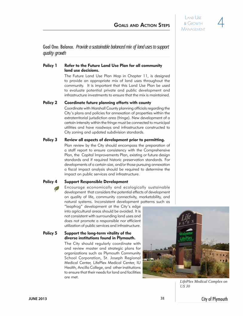
Policy 5 Support the long-term vitality of the diverse institutions found in Plymouth.The City should regularly coordinate with and review master and strategic plans for organizations such as Plymouth Community School Corporation, St. Joseph Regional Medical Center, LifePlex Medical Center, IU Health, Ancilla College, and other institutions to ensure that their needs for land and facilities are met.
gOAls AND ACTiON sTEPs
LifePlex Medical Complex on US 30

32Comprehensive Plan
4 Land Use & Growth
ManaGeMent
Policy 6 Coordinate Land Use, Transportation and Infrastructure PlanningSuccessful communities coordinate land use, transportation and infrastructure planning policies. The intensity of land uses should correspond to appropriate road classifications and extension of municipal services.
Policy 7 Pro actively plan for development on the 7A Road Bypass. Plan for potential development pressures as a result of the proposed 7A Road Bypass on the north side of the City. This will be a new entrance to the City. Because this corridor is proposed as a limited-access route, it is important to strategically focus desired development at key intersections and not allow strip style development on the currently rural corridor.
Action Steps...
• The City must follow and utilize the Future Land Use Map and recommendations to prevent sprawl and leapfrog development especially within the two-mile ETJ.
•Work with Marshall County Planning Staff and the Marshall County Economic Development Corporation (MCEDC) to agree to an annexation plan with strategies to annex property within the ETJ prior to development and to require municipal sewer and water connections.
• Consider creating additional corridor overlay districts or a Planned Unit Developments for mixed-use’s in target growth areas.
• Embark on strategic annexation of parcels of land on the edges of the City to facilitate the addition of new, diverse and quality residential development.
• Encourage voluntary annexation to entice the highest and best users that are consistent with the Future Land Use Map.
PROFILE: AnnexationThere are many viable reasons for a community to consider annexation. • A city or town can only collect taxes within
its incorporated area. Annexation assists communities in achieving a better balance between users of public services, like roads, parks and recreation, waste management, economic development efforts, and others, and those who actually pay into the taxing system that supports them.
• Annexation can assist a community to manage emergency services more comprehensively by collecting them into one unit of jurisdictional government.
• Annexation can help a community better plan for its future. Certain areas may be desirable for either focused growth or protection from development. By annexing that land, plans can be put in place to ensure that the goals of a city or town are supported with regard to the land on a community’s edges.
• Annexation can provide an effective growth management tool. Communities often implement policies that require potential municipal utility customers to agree to voluntary annexation either at the time of extension or in the future, as determined by local decision-makers.
• Annexation provides a voice to residents and businesses who previously may have been outside of the incorporated limits, but were affected by policies being made within the community. By annexing them, they are given opportunities to participate in public policy and run for public office.
Source: Adapted from “Why Annex?” -
City of Kokomo,
http://www.cityofkokomo.org
gOAls AND ACTiON sTEPs (CONT.)

33 City of Plymouth
4Land Use & Growth
ManaGeMent
JUNE 2013
Goal Two: Industrial Development. Ensure a sustainable supply of “development ready” industrial locations.
Policy 1 Develop a unified strategy for attracting new business and industry to the community and retaining and expanding the existing.The City should continue to work closely with the Marshall County Economic Development Corporation (MCEDC) to focus efforts on a strategy to recruit specific businesses matching them with the local workforce and business expansion. Showcase existing and develop additional amenities, to use Plymouth’s quality of life as a marketing tool. This process should be facilitated a staff person partially focused on economic development and working with local business organizations
Policy 2 Increase the number of development-ready sites.Identify and promote development-ready sites utilizing MCEDC resources. In addition to providing good highway and rail access, ensure that municipal utilities are available and capable of servicing desired employers.
Policy 3 Focus on attracting diverse and innovative employers to Plymouth.Business recruitment efforts should include attracting high-tech, research and development, and light industrial employers as well as, manufacturing, and food processors to the community. Technology and science continue to evolve, creating markets for cutting-edge businesses to tap into. Plymouth should be active in attracting this type of employer as a means of providing high-paying jobs, thought the skills of the workforce will need to be enhanced.
Policy 4 Support existing and creative incentives to bring new employers to Plymouth.Plymouth’s Tax Increment Financing (TIF) districts and revised tax abatement application can be an effective tool for encouraging new commercial and industrial development. Other incentives may include, streamlined permit processing, waived, or reduced utility and connection fees.
Action Steps...
• Create a master plan with realistic phasing and current site criteria for the industrial parks to encourage collective promotion to catalyze investment during and beyond the economic recession.
gOAls AND ACTiON sTEPs (CONT.)
Ensure sites are development ready

34Comprehensive Plan
4 Land Use & Growth
ManaGeMent
• Consider a long term relocation plan for industrial businesses located in downtown traditional residential designated areas between the Norfolk Southern Railroad and Plum Street. This area is most appropriate for redevelopment for citizens to live, shop and play and is critical to bridge the community.
• Re-purpose portions of undeveloped industrial land to other diverse uses that may develop sooner and provide revenue and be an amenity for the community.
• Update and revise the City’s tax abatement policies and application. Specifically, the criteria should focus on ensuring that tax abatements are attracting high-paying jobs to the community and that new businesses are committed to Plymouth for the long-term. Make City policies consistent with county tax abatement policies to be competitive. Flexibility in TIF policies can similarly be used to encourage new development.
• Reestablish the mission of the Plymouth Industrial Development Corporation (PIDCO) to focus on industrial development or form a new organization with the mission to promote developable land and enhance the skills of the workforce.
• Consider the amount of and character of light industrial zoned land in the vicinity of Pioneer Road and south of the CSX Railroad.
Profile: Fiscal Impact AnalysisFiscal Impact Analysis (FIA) is a tool that can be used to determine the fiscal impact that a proposed development will have on the local government’s ability to provide needed infrastructure and services to that development. It compares the tax revenue generated by the proposed development with the services it will require (roads, utilities, public safety, schools, etc.) and the resulting public cost of providing those services. In this way, the local government can gauge whether the proposed development would possibly pay for itself or if it would create a fiscal strain on the community.
Fiscal Impact Analyses must be based on the most recent, accurate data.• First, operating costs (cost of public services) for each public ser-
vice must be prepared. This can be done on a detailed level by determining the cost of providing services to different land use types. The result is a series of multipliers that can represent the per-acre or per-unit cost of providing each community service.
• Second, estimate the revenues that the community would col-lect from the proposed development considering all local taxing districts (property, school, library, parks, etc.).
• Finally, compare the results. If the comparison determines that a development’s “cost” to the community will exceed the revenue, other tools, like impact fees (Profile: Impact Fees, page 51), can be used to offset this condition.
All proposed annexations should be analyzed by a qualified third party to provide an unbiased recommendation related to “Fiscal Impact Analysis”. It should be noted that this is an estimate only, and that it should not be used as the sole decision-making tool when a land use proposal is evaluated. It can, however, prove to be an enlightening process for local officials and the public if implemented effectively.
gOAls AND ACTiON sTEPs (CONT.)

35 City of Plymouth
4Land Use & Growth
ManaGeMent
JUNE 2013
Goal Three: Commercial-Mixed Use Development. Unify existing mixed-use development and create commercial and residential opportunities to produce desirable, livable environments.
Policy 1 Support high-quality commercial development in Plymouth.The experience of many visitors to the community is defined by their impression of the commercial areas that they visit. Commercial development should be designed to be representative of the image that Plymouth would like to portray. Strong development standards and guidelines can help to ensure that commercial areas remain attractive and well-maintained.
Policy 2 Enhance Corridor DevelopmentEncourage high-quality development and redevelopment of sites, buildings, and amenities for commercial and industrial properties along U.S. 30, U.S. 31, Michigan, and Jefferson Street Corridors.
Policy 3 Consider Alternative Uses for Underutilized LandPortions of Plymouth’s designated industrial land is idle and not reaping benefits of the initial investment. Consider re-purposing some of the land, where compatible, to alternative uses such as recreational and entertainment venues or quality multifamily housing.
Policy 4 Encourage diverse types of residential opportunities within the City The City should seek developers to refresh the housing stock and provide alternative housing types for all ages and demographic groups at or near locations to support and meet the needs of the marketplace (see also Chapter 5 Housing & Neighborhoods).
Action Steps...
• The Redevelopment Commission should prepare a phased plan to redevelop underutilized City center industrial areas to create a bridge between eastern and western halves of the City and to create a “walkable community”.
• Create a master plan for new and redeveloped commercial and mixed-use development treating each as a district to shop, eat, and live.
• Encourage existing development and require new development on primary and minor arterials, and major collector thoroughfares to
gOAls AND ACTiON sTEPs (CONT.)
Downtown Corridor

36Comprehensive Plan
4 Land Use & Growth
ManaGeMent
provide cross-access easements and/or shared driveways.
• New buildings should have small front setbacks with parking to the rear or side of the structure.
• Development proposals should address not only site, building and parking layout, but address tracffic, signage, connectivity and landscaping. Require a traffic impact status when needed.
• Update the Subdivision Control Ordinance to include 21st Century standards for development and design.
• Enforce the Zoning Ordinance in the incorporated and extra territorial jurisdictions to ensure compliance with required development and design standards. Code enforcement efforts should include a multi-lateral approach which includes the Police Department, Public Works Department, Street Department and Building Department. This approach will maximize effectiveness.
Goal Four: Municipal Airport. Support the sustained viability of the Plymouth Municipal Airport.
Policy 1 Ensure maximum economic benefit to the community from the airport location.The Plymouth Municipal Airport is an important resource for the economic health of the community It is an asset that provides an option for businesses operating nationally and globally. The Board of Aviation Commissioners is committed to the expansion and bolstering uses.
Action Steps...
• Prior to making significant improvements at the airport, prepare a demand feasibility study to ensure optimal return on investment.
Commercial development on US 30 could benefit from enhanced site and architectural standards
gOAls AND ACTiON sTEPs (CONT.)

37 City of Plymouth
4Land Use & Growth
ManaGeMent
JUNE 2013
• Update Airport Area Overlay Zoning District to indicate the extent of the airport’s five protected zones reflecting current state and federal regulations. This would also protect the investments of property and business owners in the vicinity of the airport.
• Engage the City’s economic development specialist and/or MCEDC to assist with recruiting aviation related tenants for the airport’s existing facilities and to develop new facilities.
• Complete an Airport Master Plan and include action items within.
Goal Five: Create More and Better Residential Options within Plymouth Corporate Limits. Ensure there is a supply of land for new residential development.
Policy 1 Encourage a Diverse Inventory of HousingEvaluate existing housing stock and annex areas on the edge of the City to create additional types of housing to ensure a balance of housing (ownership, pricing, style, and type) and to serve all segments of the market equally (age, income, race/ethnicity).
Policy 2 Respect the Natural EnvironmentDo not permit subdivisions of four units or more to develop near sensitive floodplain or wetlands within the City or the two-mile ETJ without being connected to City water and wastewater utilities.
Abandoned site ripe for redevelopment
gOAls AND ACTiON sTEPs (CONT.)

38Comprehensive Plan
4 Land Use & Growth
ManaGeMent
Policy 3 Consider Impacts to Local Infrastructure and School Systems During Approval ProcessesWork with the County to consider the impact to school, park, and property tax systems prior to residential development approval. Encourage developers subdivisions over 50 units to conduct fiscal impact analyses and address direct impact to infrastructure and roadway facilities.
Policy 4 Encourage Connectivity and “Walkability”Maintain appropriate lighting and safe, pedestrian-friendly sidewalks and multi-use trails within and between neighborhoods and commercial areas, schools, churches, and/or recreational facilities.
Action Steps...
• Assemble tracts of property in a cohesive, connected format.
• Update the Subdivision Control Ordinance. Require all new subdivisions of more that 4 units to connect to municipal sewer and water and annex when contiguous to the Corporate Boundary. Encourage development which provides connected streets, sidewalks and trails, and that follow City engineering standards.
• Require developers to complete fiscal impact studies for developments over 50 units prior to platting and encourage Planned Unit Development’s (with commitments recorded). Such developments enhance connectivity through developer driven infrastructure installation.
• Encourage the infill of vacant residential sites throughout the City for community re-investment and housing diversity.
• The City must follow and utilize the Future Land Use Map and recommendations to prevent sprawl and leapfrog development especially within the two-mile ETJ.
• Work with Marshall County Planning Staff and the Marshall County Economic Development Corporation (MCEDC) to agree to an annexation plan with
strategies to annex property within the ETJ prior to development and to require municipal sewer and water connections.
• The City should seek developers to refresh the housing stock and provide alternative housing types for all ages and demographic groups at or near locations to support and meet the needs of the marketplace.
gOAls AND ACTiON sTEPs (CONT.)
Infill development can help re-energize older neighborhoods.
See also Chapter 5: Housing and Neighborhoods

City of PlymouthJUNE 2013
HOUSING & NEIGHBORHOODS
SECTION I - Goals & Action Steps 5

40Comprehensive Plan
5 Housing & neigHborHoods
Many of the concerns expressed for housing in the 2003 Comprehensive Plan still exist 10 years later and many were worsened by the prolonged recession that began in 2007 and has continued to depress incomes and residents’ ability to afford a home. According to the census statistics from 2011, income has dropped driving people to seek rental options. There is a noted lack of livable, appealing rental properties or alternatives to single family homes at all income levels.
Homes, especially historic ones, along tree-lined Michigan Street form a first impression not long forgotten. Some are subdivided into multiple units and others may be in need of repair but there is no discounting the beauty of the single-family detached residences. Unfortunately they form a tiny percentage of the housing available in the City of Plymouth, and once you step or drive off of Michigan Street, the disparity is obvious. Instead of investing in the rehabilitation of an originally well-built older home and opting for a traditional urban neighborhood, many moved to newer homes in subdivisions outside of the City in the ETJ. This is somewhat contrary to recent city trends of dwellers opting for homes within walking distance of parks, retail and community services.
It is important that the City preserve and enhance its neighborhoods. Though the City does not have a housing authority or community development corporation there is a Redevelopment Commission that could assist in improving core neighborhood properties. These neighborhoods must remain healthy, dynamic and populated if the community is to be sustainable.
Any neighborhood efforts must begin with the older, core neighborhoods surrounding Plymouth’s downtown. Housing options such as duplexes, multi-level apartment buildings and town homes integrated into the existing street network replete with sidewalks, street trees, and utilities, quality building materials must be developed. Precedents for this urban design model were established in the Andrews University Plan for Downtown (2005). The success of any recommendations made in this chapter or the section on Redevelopment Opportunities will lie in the success of the City leaders communicating with developers on “The right approach for the City”.
One of the many architecturally significant homes in Plymouth’s core neighborhoods.
Goal One: Historic Character. Preserve the historic character and development pattern of Plymouth’s core neighborhood areas.
Policy 1 Ensure that new development in Plymouth’s core neighborhoods respects the historic development pattern.The physical form of Plymouth’s core neighborhoods was shaped by standards in place at the time of their development. Current development regulations often do not match the existing neighborhood pattern and can lead to incompatible development that detracts from the neighborhood character.
iNTrODUCTiON TO hOUsiNg AND NEighbOrhOODs
gOAls AND ACTiON sTEPs

41 City of Plymouth
5Housing & neigHborHoods
JUNE 2013
Policy 2 Regulate the conversion of single-family homes to multifamily units in core neighborhoods.Current zoning allows some single-family homes in core neighborhoods to be subdivided into multiple apartment units. Incompatible division of single-family homes into multifamily units by absentee landlords can have a detrimental effect on neighborhood character and the condition of the structures themselves, leading to blight, disinvestment, and lowered quality of life for residents. A multifamily conversion permit process should be developed to ensure that property owners comply with a set of guidelines that help maintain the buildings’ architectural integrity and neighborhood character. Moreover rental registration and inspection could be required.
Policy 3 Support the historic preservation activities of local organizations.The City does not currently have a historic preservation commission to oversee preservation efforts in Plymouth. Many preservation and enhancement activities are undertaken by the Wythougan Valley Preservation Council. Tax credits are available for those that choose to refurbish properties.
Policy 4 Enhance Pedestrian ComfortFor all downtown neighborhoods, future street improvements should include decorative street lighting, tree lawns to accomodate street trees, and wide sidewalks to enhance the overall quality and character of the public realm.
Action Steps...
• Develop a multifamily conversion permit application process to ensure that property owners dividing single-family homes comply with a set of guidelines that help maintain the buildings’ architectural integrity and neighborhood character and ensure tenant safety.
• Adhere to the Downtown and Historic Neighborhood Overlay Districts in the Zoning Ordinance to maintain the existing neighborhood fabric.
• Support and celebrate groups with a mission to preserve Plymouth’s urban neighborhoods and downtown. Support the “Indiana Main Street” - Plymouth group.
• Enhance the pedestrian setting by extending decorative streetscape features onto some east-west streets including Jefferson, Garro, Washington, and Adams link the downtown and river with neighborhoods west of the railroad and east of the Yellow River.
• Consider the creation of a Local Historic District or Neighborhood Conservation district to get assistance to Plymouth’s core neighborhoods.
Sympathetic conversion of single-family home to multifamily units maintains the architectural integrity, enhances neighborhood character and promotes investment.
gOAls AND ACTiON sTEPs (CONT.)

42Comprehensive Plan
5 Housing & neigHborHoods
Profile: Neighborhood Conservation DistrictsA Neighborhood Conservation District (NCD) is a preservation tool similar to a local historic district, and applied as an overlay to the regular (base) zoning ordinances. The purpose of a NCD is to preserve the unique features, or characteristics, of a neighborhood that contribute to the culture, history, and overall development of the larger community. Such a preservation tool can reduce conflicts and prevent blight as a result of incompatible or insensitive development. It also includes design standards for the placement and construction of new buildings, signage, or similar outdoor structures. However, regulations for a NCD are tailored to the needs of a particular area or neighborhood, and are generally less strict than those for historic districts. The establishment of such a district recognizes the particular design and architectural qualities of a neighborhood, and encourages the protection and maintenance of such features for the benefit of the entire city. NCD’s are often implemented in response to neighborhood changes that undermine the community’s character such as incompatible development, vacant lots, or commercial encroachment in residential areas. These neighborhoods generally do not merit historic district status, but do contain significant character contributing to the larger community, and are worthy of preservation or protection. NCD’s are used by neighborhoods that may not qualify for inclusion in the National Register of Historic Places, or are not ready for local historic designation.
The creation of a Neighborhood Conservation District should be coordinated with the City of Plymouth’s Department of Planning and Zoning and affected property owners. Property owners should have the opportunity to assist in developing the boundaries and subsequent guidelines for the conservation plan, and a majority of owners must ultimately support such a measure as part of the approval process. A set of guidelines would need to be developed and a governing board established to approve new construction, demolition, and alterations visible from a public way. These guidelines would establish a benchmark to determine the acceptability of a property owner’s proposed changes. The guidelines generally include penalties for violations and procedures for appeals and enforcement. Stipulations or guidelines for Plymouth’s NCD could vary depending on the concerns of the residents and businesses in the affected areas. The goal is to protect the physical attributes of a neighborhood by addressing changes that could adversely affect its architectural character.
In the case of downtown Jeffersonville, the implementation of a NCD could be used as a way to “insulate” the historic integrity of a specific neighborhood. This effort would not only protect remaining structures, but could be a proactive approach to guide future development in areas under pressure from incompatible development, vacant lots, or commercial encroachment. A Neighborhood Conservation District could be an effective means to protect the character of these areas in order to maintain the integrity and viability of Downtown Plymouth and surrounding neighborhoods.
gOAls AND ACTiON sTEPs (CONT.)

43 City of Plymouth
5Housing & neigHborHoods
JUNE 2013
Goal Two: Core Neighborhood Vitality. Maintain the vitality and appeal of Plymouth’s core neighborhoods.
Policy 1 Enhance community infrastructure such as sidewalks, drainage, and street trees in core neighborhoods.One of the most important indicators of the health of a neighborhood is the state of repair of its infrastructure. Features such as sidewalks, drainage and street trees can have a major impact on the well-being of neighborhoods. Bringing such infrastructure into working order in areas of need can add a tremendous boost to a neighborhood’s vitality.
Policy 2 Support the enforcement of Plymouth’s property maintenance codes.Public infrastructure maintenance must be complemented by efforts on the part of property owners to maintain safe and attractive structures and properties.
Policy 3 Promote Infill and Mixed-Use RedevelopmentDesignate vacant or under utilized properties for mixed-use developments that include housing compatible with other land uses such as retail or office space. One benefit of this type of development is access to existing streets and sidewalks and the use of existing municipal utilities in comparison to the high cost of new infrastructure (utility, roadway, sidewalks, street lights). Reduced or waived fees can be an incentive for a developer.
Policy 4 Support neighborhood-based improvement initiatives.Many neighborhoods can identify small projects that would greatly enhance their livability and attractiveness, but funding for those projects is often difficult to secure. The City should support projects that improve neighborhoods and instill a sense of community without a substantial investment.
Policy 5 Encourage Connectivity and “Walkability”Maintain safe, pedestrian-friendly sidewalks and appropriate lighting within neighborhoods and between neighborhoods and commercial areas, schools, churches, and/or recreational facilities.
Action Steps...
• The Redevelopment Commission should partner with the county, a non-profit agency or private developer to construct a signature housing project that would be a catalyst for redevelopment in the western downtown area.
• The City should evaluate the programs it currently funds that could assist neighborhoods with small scale improvement projects. These programs should be aggressively publicized to ensure that neighborhood residents are aware of available opportunities. Possible programs include matching funds, tree plantings and other beautification efforts.
• The City must continue its efforts enforcing explicit regulations to hold property owners accountable for maintaining their properties. This can be accomplished by continuing to track and analyze enforcement actions and by researching rental registry and inspection programs such as those in Bloomington and Lebanon, IN.
Sidewalks, street trees and appropriate lighting are important elements of walkable, neighborhoods.
gOAls AND ACTiON sTEPs (CONT.)
See also Chapter 6: Downtown and Chapter 12: Focus Area Concepts.

44Comprehensive Plan
5 Housing & neigHborHoods
Source: Andrews University Plan for Downtown, 2004
Andrews University Plan for DowntownThe western downtown is currently characterized by mostly under utilized real estate, abandoned industrial buildings,vacant lots and streets which are generally in disrepair. This plan proposes that the City collaborate with existing owners and the private development sector in repairing existing infrastructure, re-parcelling lots, and redeveloping the entire western downtown into a mixed-use but predominantly residential area. And while a variety of dwelling types should be provided, it ought to be ensured that a considerable portion of new houses are attractive to the middle and upper markets.
To facilitate this, an abandoned railway R. O. W. can serve to extend existing First Street towards the south, connecting it with the remaining street grid. This extended First Street would then terminate at the old masonry depot, which may be restored as the City’s art center.
The great benefit of large-scale redevelopment - in conjunction with a master plan - is that aesthetics and quality can be controlled to an extent which encourages new home-buyers to consider investment in the first place. Initial studies suggest that the western downtown could include up to 160 dwelling units, all within a five-minute walk of Michigan Street.
Excerpt from the 2005 Andrews University Plan for Downtown.
gOAls AND ACTiON sTEPs (CONT.)
NTS

45 City of Plymouth
5Housing & neigHborHoods
JUNE 2013
Goal Three: Housing Diversity. Provide diverse and affordable housing options for all residents of Plymouth.
Policy 1 Provide a variety of housing OptionsSupport neighborhood revitalization and infill projects that provide homes for all income levels. Ideally, traditional downtowns should offer a variety of housing options that result in a vibrant mix of residents and create a critical mass of people to support commercial activities. Diverse housing types include apartments, single family homes, townhomes, second story lofts, and duplexes.
Policy 2 Provide adequate housing options for senior citizens in the community.As the population of Plymouth ages, more people will desire housing opportunities convenient to medical, retail, recreation services. People will also require various levels of healthcare.
Policy 3 Support the rehabilitation of homes in older neighborhoods as a method of providing affordable housing.One way of providing opportunities for affordability and homeownership is to make improvements to existing homes in Plymouth’s older neighborhoods. Infrastructure costs would be minimal as all necessary utilities and services are already present. Rehabilitation, including energy efficiency upgrades, of existing housing units and creation of new homes should be balanced in the overall strategy for affordable housing in Plymouth.
See also Chapter 12: Focus Area Concepts.
gOAls AND ACTiON sTEPs (CONT.)
New multi-family housing can successfully be integrated into older neighborhoods.

46Comprehensive Plan
5 Housing & neigHborHoods
Action Steps...
• The City should consider strategic annexations of land in order to provide opportunities to produce quality residential development of various types and densities within the corporate limits.
• Review the Zoning and Subdivision Control Ordinances to ensure they do not prohibit traditional neighborhood development patterns on small, urban lots and do not permit suburban style development within the urban core.
• Seek out quality builders that are willing to construct quality, walkable single family traditional, duplex, townhome and multifamily type housing and neighborhoods that are in keeping with the character Plymouth desires.
• Explore public-private partnerships for the rehabilitation of existing housing that by nature is more affordable than new. The City could streamline permit processing, reduce user fees, or similar costs associated in home-building, allowing for lower final costs to the buyer.
• Explore the creation of a City Housing Authority, or Community Housing Development Corporation (CHDO) that can seek out funding opportunities through the Indiana Housing and Community Development Authority (IHCDA) to rehabilitate existing homes.
• Develop a program that provides technical and/or funding assistance for qualified homeowners interested in restoring or rehabilitating older homes in traditional downtown neighborhoods. Continue “Operation Bright Spot” initiatives.
• The City should seek developers to refresh the housing stock and provide alternative housing types for all ages and demographic groups at or near locations to support and meet the needs of the marketplace
gOAls AND ACTiON sTEPs (CONT.)
Additional dwelling units often times provide a source of income for property owners to defray the cost of rehabilitating properties.

47 City of Plymouth
5Housing & neigHborHoods
JUNE 2013
Profile: Housing DiversityIn community planning terms, housing is generally divided into single-family (referring to a detached residence), two-family (duplex), and multifamily (three or more attached units). Multifamily can also include residential units that are incorporated into mixed-use developments, such as apartments and condominiums that may be found above commercial businesses in downtown or within a renovated factory. Each of these housing types can be owner-occupied or rented. Rental housing may be market-rate or subsidized.
Plymouth’s Housing NeedsIt is well known that many of Plymouth’s citizens are proud of the quality of life provided in the community. Schools and an ever expanding parks and greenways system tend to be highly valued, especially by families. Citizen input and general observation suggest that the same care and investment have not occurred with respect to housing for all income levels within the City. It is important for the long-term vitality of the community to provide housing alternatives that are affordable to lower income households or that appeals to empty nesters and young professionals such as townhomes, condominiums, complexes, and other options.
Rental Housing Within Plymouth, there is a shortage of quality market-rate rentals such as apartments, townhomes, and duplexes. Developers across the country are building high-quality, innovative rental housing with amenities that are visually appealing and contextual. The use of durable building materials, well-landscaped grounds, pools, clubhouses, tennis courts, garages or screened parking, courtyards, or walking trails are just a few of the ways to create community-compatible developments whether located in suburban or urban neighborhoods, or within downtown.
Affordable HousingSome of these housing types are often referred to as “affordable”. A common misconception is that “affordable” means “subsidized”. Subsidized housing is utilized by low- or very low-income households who cannot afford to occupy market rate housing due to disability, age, or other factors. Affordable housing is defined as housing that costs the occupant no more than 30% of a household’s income including taxes and utilities. This can apply to all income levels.
Regardless of affordability, location (urban, suburban, or rural), or density, housing should always be created in ways that lengthen life spans and encourage durability and sustainability. Ways to accomplish this include utilizing attractive, durable building materials, well-landscaped lawns and common areas, garages or screened parking, courtyards, or walking trails ,among others.
Plymouth could also assist those wishing to provide this type of housing by directing developers to targeted redevelopment areas, assisting with land assembly, and having ordinances that encourage mixed-uses, such as downtown housing downtown located above retail or offices, or higher-density housing, such as in redevelopment areas.
Another funding mechanism to assist potential homebuyers is a Community Housing Development Organization (CHDO), that develops, owns, and manages properties. Community Development Block Grants, HOME Investment Partnership Awards, and Indiana Low Income Housing Trust Fund Awards typically provide funds to housing development projects done by CHDOs and governments.
gOAls AND ACTiON sTEPs (CONT.)

48Comprehensive Plan
5 Housing & neigHborHoods
Goal Four: Quality Housing and Neighborhood Design. Enhance the quality of residential and commercial design elements in new development.
Policy 1 Prioritize the reinvestment and redevelopment of existing Neighborhoods.Ensure that design standards for site layout, the streetscape, structures, materials, and associated amenities are included for residential and commercial infill and redevelopment. Provide a mix of quality housing types at different price points. It is important to attract young couples and first time home buyers to the City.
Policy 2 Seek developers for new quality subdivision development on City edges but within the City limits as an alternative to County residential.Conduct strategic annexations for new subdivision development with municipal utilities and in proximity to Plymouth’s fine offerings.
Policy 3 Require municipal utilities.Major subdivisions for residential, commercial and industrial development should be required to connect to municipal utilities and provide standard subdivision amenities including sidewalks, streetlights, stormwater systems, open space and street trees. Individual, unplatted lots greater than two acres may be exempt from connecting to public utilities provided Indiana Department of Environmental Management and Marshall County Health Department regulations are adhered to.
Policy 4 Ensure connectivity between neighborhoods and the overall street network.Multiple access points should be provided to new neighborhoods for both vehicles and pedestrians. Neighborhoods should also be connected to each other with local streets and sidewalks as means of reducing traffic on adjacent collector and arterial roadways. Require stub-streets connect to future development. Streets must be public and follow Development Standards.
Policy 5 Integrate common open space into new neighborhoods.Opportunities to provide park space within new neighborhoods over a certain size (50 units) should be pursued and a Homeowner’s Association (HOA) established. This area should be designated as common open space or may be considered for acquisition by the City.
Policy 6 Promote Pedestrian-Scaled Infrastructure Encourage traffic-calming features such as landscaped medians, bump-outs at intersections, or on-street parking on some streets to slow vehicular traffic and increase safety for pedestrians, bicyclists and other non-motorized users.
Policy 8 Universal Design for New Homes Universal Design is about creating a place for residents to live and for guests to visit regardless of age, size, or ability.
gOAls AND ACTiON sTEPs (CONT.)
Example of new residential subdivision with a variety of housing styles.
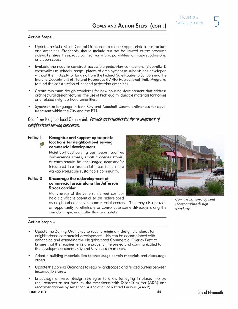
49 City of Plymouth
5Housing & neigHborHoods
JUNE 2013
Action Steps...
• Update the Subdivision Control Ordinance to require appropriate infrastructure and amenities. Standards should include but not be limited to the provision sidewalks, street trees, road connectivity, municipal utilities for major subdivisions, and open space.
• Evaluate the need to construct accessible pedestrian connections (sidewalks & crosswalks) to schools, shops, places of employment in subdivisions developed without them. Apply for funding from the Federal Safe Routes to Schools and the Indiana Department of Natural Resources (IDNR) Recreational Trails Programs to fund the construction of needed pedestrian amenities.
• Create minimum design standards for new housing development that address architectural design features, the use of high quality, durable materials for homes and related neighborhood amenities.
• Synchronize language in both City and Marshall County ordinances for equal treatment within the City and the ETJ.
Goal Five: Neighborhood Commercial. Provide opportunities for the development of neighborhood serving businesses.
Policy 1 Recognize and support appropriate locations for neighborhood serving commercial development.Neighborhood serving businesses, such as convenience stores, small groceries stores, or cafes should be encouraged near and/or integrated into residential areas for a more walkable/bikeable sustainable community.
Policy 2 Encourage the redevelopment of commercial areas along the Jefferson Street corridor.Many areas of the Jefferson Street corridor hold significant potential to be redeveloped as neighborhood-serving commercial centers. This may also provide an opportunity to eliminate or consolidate some driveways along the corridor, improving traffic flow and safety.
Action Steps...
• Update the Zoning Ordinance to require minimum design standards for neighborhood commercial development. This can be accomplished with enhancing and extending the Neighborhood Commercial Overlay District. Ensure that the requirements are properly interpreted and communicated to the development community and City decision makers.
• Adopt a building materials lists to encourage certain materials and discourage others.
• Update the Zoning Ordinance to require landscaped and fenced buffers between incompatible uses.
• Encourage universal design strategies to allow for aging in place. Follow requirements as set forth by the Americans with Disabilities Act (ADA) and reccomendations by American Association of Retired Persons (AARP).
gOAls AND ACTiON sTEPs (CONT.)
Commercial development incorporating design standards.

50Comprehensive Plan
5 Housing & neigHborHoods
Page left intentionally blank.

City of PlymouthJUNE 2013
DOWNTOWNSECTION I - Goals & Action Steps 6

52Comprehensive Plan
6 Downtown
Downtown Plymouth is the true focal point of the community. It provides a dynamic mix of uses including retail stores, restaurants, government offices and other key activity centers that are integral to the community and local economy. It also provides a sense of place that cannot be found in other parts of the community. The City and other local organizations including Plymouth Main Street and Plymouth Industrial Development Corporation (PIDCO) have done an admirable job of maintaining a vibrant downtown as the civic center of the City.
Downtown Plymouth retains many late-nineteenth and early-twentieth century commercial buildings, most reflecting the Italianate, Romanesque Revival, or Neoclassical styles. These buildings are all two or three stories in height and their facades help to define the street as an outdoor room. The buildings were designed
to house commercial space at the first floor, with office space, apartments, or warehouse space on the upper floors. Appreciation for the town’s unique character and historic architecture helped to draw new attention to downtown Plymouth during the 1980’s and 1990’s. Prior to this time, many architecturally and historically significant buildings like the Centennial Opera House (1876) were demolished.
Plymouth has a history of supporting the vitality of its downtown. Within the past decade several plans were developed for the downtown area. Those plans are the Downtown Strategic Plan (2004), the Andrews University Plan for Downtown (2005) and the
Riverfront Park Master Plan. In addition, a façade improvement grant program was established to rehabilitate the facades of many buildings along Michigan Street. These types of strategic projects serve as catalysts for reinvestment in the community. Physical improvements help draw attention and interest to the downtown area, benefiting local businesses and reinforcing a sense of community pride. Maintaining a mix of shops, restaurants, services and offices helps to ensure that the downtown area remains a vibrant and active place.
Plymouth is fortunate to have a relatively compact form, with a grid of streets providing many route options. The City’s compact layout was established during the late-nineteenth and early-twentieth centuries and continues to this day. This plan suggests strengthening the grid and reconnecting the neighborhoods near downtown. Careful attention must be given to creating safe and convenient access
to downtown for pedestrians, bicyclists, and motorists. It is crucial that the walkability of the downtown area be maintained and enhanced to serve all users. Walking through downtown must be both safe and attractive. Recent streetscape improvements such as street trees, brick pavement accents, sidewalk planters, and decorative street lamps has improved the experience of place.
Overall, a holistic approach to coordinating parking, business diversity, and physical improvements must be taken. This chapter provides goals and strategies that will help Plymouth preserve and extend the enhancements in the downtown area. Further guidance can be found in Chapter 11, Land Use Plan.
Wik
imed
ia C
omm
ons
Mar
shal
l Cou
nty
Inte
rim R
epor
t
Two- and three-story commercial buildings on Michigan Street
with office and residential space over first-floor retail space
Many architecturally and historically significant buildings
like the 1876 Centennial Opera House (far right) were
demolished during the late-twentieth century
iNTrODUCTiON TO DOwNTOwN PlymOUTh
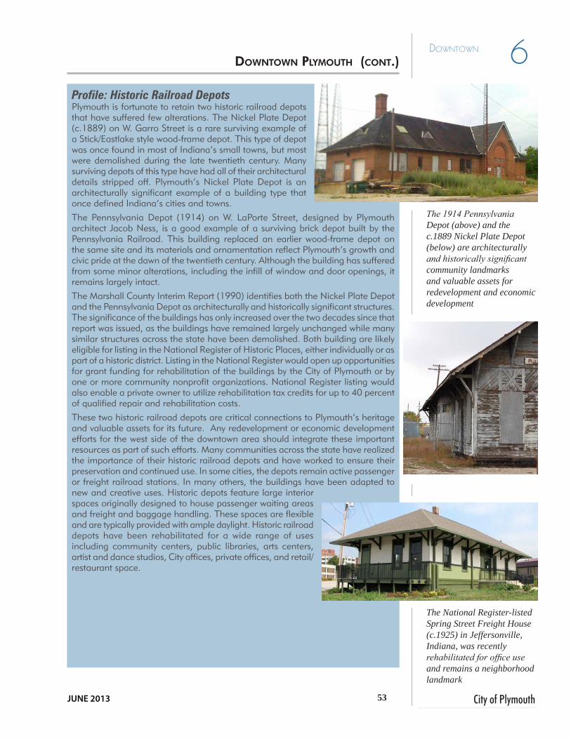
53 City of Plymouth
6Downtown
JUNE 2013
The 1914 Pennsylvania Depot (above) and the c.1889 Nickel Plate Depot (below) are architecturally and historically significant community landmarks and valuable assets for redevelopment and economic development
Profile: Historic Railroad Depots Plymouth is fortunate to retain two historic railroad depots that have suffered few alterations. The Nickel Plate Depot (c.1889) on W. Garro Street is a rare surviving example of a Stick/Eastlake style wood-frame depot. This type of depot was once found in most of Indiana’s small towns, but most were demolished during the late twentieth century. Many surviving depots of this type have had all of their architectural details stripped off. Plymouth’s Nickel Plate Depot is an architecturally significant example of a building type that once defined Indiana’s cities and towns.
The Pennsylvania Depot (1914) on W. LaPorte Street, designed by Plymouth architect Jacob Ness, is a good example of a surviving brick depot built by the Pennsylvania Railroad. This building replaced an earlier wood-frame depot on the same site and its materials and ornamentation reflect Plymouth’s growth and civic pride at the dawn of the twentieth century. Although the building has suffered from some minor alterations, including the infill of window and door openings, it remains largely intact.
The Marshall County Interim Report (1990) identifies both the Nickel Plate Depot and the Pennsylvania Depot as architecturally and historically significant structures. The significance of the buildings has only increased over the two decades since that report was issued, as the buildings have remained largely unchanged while many similar structures across the state have been demolished. Both building are likely eligible for listing in the National Register of Historic Places, either individually or as part of a historic district. Listing in the National Register would open up opportunities for grant funding for rehabilitation of the buildings by the City of Plymouth or by one or more community nonprofit organizations. National Register listing would also enable a private owner to utilize rehabilitation tax credits for up to 40 percent of qualified repair and rehabilitation costs.
These two historic railroad depots are critical connections to Plymouth’s heritage and valuable assets for its future. Any redevelopment or economic development efforts for the west side of the downtown area should integrate these important resources as part of such efforts. Many communities across the state have realized the importance of their historic railroad depots and have worked to ensure their preservation and continued use. In some cities, the depots remain active passenger or freight railroad stations. In many others, the buildings have been adapted to new and creative uses. Historic depots feature large interior spaces originally designed to house passenger waiting areas and freight and baggage handling. These spaces are flexible and are typically provided with ample daylight. Historic railroad depots have been rehabilitated for a wide range of uses including community centers, public libraries, arts centers, artist and dance studios, City offices, private offices, and retail/restaurant space.
The National Register-listed Spring Street Freight House (c.1925) in Jeffersonville, Indiana, was recently rehabilitated for office use and remains a neighborhood landmark
DOwNTOwN PlymOUTh (CONT.)
54Comprehensive Plan
6 Downtown
Goal One: Preservation. Preserve the historic fabric of Downtown Plymouth.
Policy 1 Extend the preservation effort beyond Michigan Street Plymouth’s downtown is listed on the National Register of Historic Places. Efforts that have preserved the architecture on Michigan Street should continue to structures beyond.
Policy 2 Maintain the variety of architectural stylesCelebrate the authenticity of downtown Plymouth by encouraging a mix of styles and densities for future infill development. It is important that any future redevelopment occurring north of Jefferson or south of Lake Street, is contextual and strengthens the overall fabric of downtown.
Policy 3 Support efforts to restore the historic railroad station(s)As noted previously, the two railroad depots are critical connections to Plymouth’s heritage and valuable assets for its future. Any redevelopment efforts for the west side of the downtown area should integrate these resources. The depots can be repurposed to house a wide range of uses including a community center, library, arts center, artists studio, office space, or retail/restaurant space.
Policy 4 Support Local Funding ProgramsDevelop a program that provides technical and/or funding assistance for qualified homeowners interested in restoring or rehabilitating older homes in traditional downtown neighborhoods.
Policy 5 Promote the Historic Crossroads CorridorWork with the Marshall County Historical Society Museum to bring the Historic Crossroads Corridor story out to the street as another attraction to downtown.
Action Steps...
• Partner with the Marshall County Historical Society Museum to promote creative programming downtown to celebrate the Historic Crossroads Corridor and the museum. This activities could take place in the downtown and be mutually beneficial to the museum and downtown businesses.
• Begin a campaign to renovate the historic railroad depot on La Porte Street. This will serve as a catalyst project for redevelopment west of Walnut Street. Apply for grant funds targeted to renovate depots
• Partner with Marshall County Tourism, convention groups, and the Plymouth Chamber of Commerce to develop a design and theme for City, County and downtown gateway signage.
gOAls AND ACTiON sTEPs

55 City of Plymouth
6Downtown
JUNE 2013
Goal Two: Activity Center. Enhance Downtown’s role as the activity center for the community.
Policy 1 Create Distinct Downtown GatewaysUse signage,. landscaping, sculpture and other means to “announce” downtown Plymouth. Team with Marshall County in an effort to create distinctive gateway features. See Gateways Map on page 24.
Policy 2 Develop programming activities and events for River Park. River Park Square is a community amenity and focal pointCoordinate with local civic, cultural, and similar downtown stakeholders to promote year-round festivals, markets, cultural events and activities for all ages.
Policy 3 Provide signage to inform visitors and residents of public off street Downtown parkingParking is a crucial issue in any downtown. It is important to remain competitive with the “big box” stores in other parts of Plymouth by providing parking downtown within a walkable distance (1300 feet or a quarter mile). Available parking in Plymouth can be accomplished in a much shorter distance than a quarter mile. A successful downtown will have a parking problem!
Profile: Walkable CommunitiesThe following characteristics are the qualities found in urban places where the pattern of development and design character combine to make frequent walking and transit use an efficient and preferred choices for many people. They also provide efficient and attractive solutions for vehicular traffic along with convenient and accessible parking. • A mix of land use types (residential, office,
retail, etc.) in close proximity to one another• Building entries that front directly onto the
street without parking between the entries and the public right-of-way (street or sidewalk)
• Building, landscaping, and roadway design that is pedestrian-scale -- the architectural details of and proportions between buildings/sidewalk widths/ frequency of street trees/etc. (urban design) are comfortable for people who are traveling on foot and observing from the street level
• Relatively compact residential and commercial developments (short distances between buildings)
• A highly-connected, multimodal circulation network (paths, sidewalks, streets, etc.), created by relatively small blocks arranged in a grid
• Thoroughfares and other public spaces that contribute to “placemaking” -- the creation of unique locations that are compact, mixed-use and pedestrian -- are transit (bus)-oriented and produce strong feelings of pride and ownership in residents which can translate to a lasting economic value
An increasing number of communities are recognizing the value of these features and are embracing them in land use, urban design and transportation plans, often using techniques drawn from planning and design movements such as smart growth and new urbanism.
Source: Adapted from “Context Sensitive Solutions in Designing Major Urban Thoroughfares for Walkable Communities; An ITE Proposed Recommended Practice”. 2006.
gOAls AND ACTiON sTEPs (CONT.)

56Comprehensive Plan
6 Downtown
Policy 4 Encourage Downtown livingAn essential part of keeping downtown active is to focus on keeping people patronizing the stores and restaurants. Continue to rehabilitate the existing traditional single-family residences, encourage residential units on the upper floors of downtown commercial buildings, and provide new “urban style” apartments, duplexes and townhomes on sites ripe for redevelopment.
Policy 5 Support and enhance linkages between core neighborhoods, the Downtown, municipal facilities and River Park Square An essential element of keeping downtown Plymouth vibrant is enhancing connections to nearby neighborhoods with a large customer base within walking distance of downtown. This includes sidewalks and/or streetscape improvements along high-profile corridors such as Jefferson Street and Garro Street to encourage pedestrian or bicycle traffic.
Policy 6 Support and Promote Initiatives to Retain Existing BusinessesThe City should continue to support incentives that support downtown businesses and evaluate existing policies or regulations that may serve as deterrents to business expansion in the downtown area. The City could also partner with stakeholders to market and promote locally.
Policy 7 Update/expand Downtown promotional campaigns Partner with local/regional tourism officials to further develop initiatives that highlight or “brand” Downtown Plymouth as a place to live, shop, work and visit throughout the region and State.
Action Steps...
• The City and the Redevelopment Commission must review the existing downtown strategic plans to prioritize projects focused on revitalizing the downtown beginning with land acquisition and assembly of parcels for redevelopment. Potential projects include renovation of the depot and development of “urban style” downtown housing near the park, at the roller rink site, and other western downtown sites.
• Strengthen downtown as a destination by continuously promoting year-round festivals, markets, cultural events, or youth activities within the downtown.
• Develop agreements to use currently underutilized parcels in the downtown exclusive of Michigan Street for parking. Provide public parking signage directing residents and visitors. Parking lots should be interior to city blocks and when not possible, should be screened from the street behind low walls (not if a temporary use) or continuous shrub plantings.
• Maintain on-street parking which provides convenient access for motorists and serves as a protective buffer between pedestrians on the sidewalk and traffic.
• Develop continuous off street greenway between River Park Square and Centennial Park.
• Work with nearby Ancilla College to encourage continued student housing within the downtown core.
gOAls AND ACTiON sTEPs (CONT.)

57 City of Plymouth
6Downtown
JUNE 2013
Goal Three: Investment. Encourage new investment in the downtown area.
Policy 1 Provide quality streets, sidewalks, drainage, and utilities so that property owners are encouraged to invest in the area.Business owners and developers are not likely to invest in an area if it appears to be in distress, therefore it is important for the City to invest in quality public infrastructure as was done on Michigan Street. This will help spur more private investment.
Policy 2 Provide economic incentives (such as tax abatements) to encourage investment in downtown.Financial incentives will be necessary to entice new investment in downtown Plymouth. This could come in the form of streamlined tax abatement process or extending boundaries of existing TIF districts to encompass areas for redevelopment.
Policy 3 Continue to support local stakeholders and other organizations focused on strategies and funding to enhance downtown Plymouth.It is important the City of Plymouth help revive and partner with Main Street Plymouth and PIDCO in pursuing opportunities to further preserve and enhance the downtown area. A focused and continuous effort to strategically expand downtown improvements and seek funding opportunities to complete important projects will be a key component of the downtown’s future.
Policy 4 Address the circulation and physical improvements at the Historic Crossroads intersection of Michigan and Jefferson StreetsMichigan Street possesses much charm in the areas both south and north of the Jefferson Street intersection, but at the intersection the charm has been replaced by commercial uses set back from the street to provide for parking in the front. Even without the moving the buildings, the intersection can be improved by including landscaping, walls, decorative signal arms, special paving at crosswalks and public art.
Policy 5 Ensure Adequate and Appropriate Downtown ParkingUpdate the inventory and analysis of parking prepared in 2004 and continue to identify potential sites for (off-street) public parking during periods of high use. Identify locations/facilities specifically for long term parking for government and business employees, and short term parking options for customers or visitors. This could be accomplished by providing a metered off-street municipally-owned parking lot that would also serve as a source of revenue.
gOAls AND ACTiON sTEPs (CONT.)

58Comprehensive Plan
6 Downtown
Action Steps...
• PIDCO should combine efforts with other downtown organizations under the umbrella of the Plymouth main street group. This will facilitate the goals of the organization to raise funds for farmer’s market development, upgrade City-owned parking lots (signage, bike parking, landscaping), fund downtown housing incentives, renovation, or redevelopment, and to fund south gateway enhancements.
• Utilize Geographic Informatiion System (GIS) tools to inventory existing downtown infrastructure conditions creating layers that detail street widths, sidewalk gaps, street and sidewalk conditions, ADA sidewalk ramp inventory, utilities, catch basins, MS4 outfalls, street signage, street tree replacement and landscaping and lack of lighting. Such a study will allow the City to prioritize future physical improvements when reviewing the yearly Capital Improvement Projects Plan.
• Since Michigan Street is also State Road 17, physical changes within the right-of-way will need to be coordinated with Indiana Department of Transportation (INDOT) representatives. The City would need to develop a conceptual plan and enter into a discussion with representatives from the local INDOT office before investing significant time and resources.
• Re-activate the Plymouth Main Street organization to serve as the primary point of contact for any initiatives in the downtown area. The City or Redevelopment Commission could assist by providing a startup fund or devoting staff time. Most of the funding should be based on a mixture of public sector, membership / sponsorship from the private sector, merchandise, and events.
• Expand the Downtown Tax Increment Finance (TIF) Districts to encompass targeted redevelopment areas.
gOAls AND ACTiON sTEPs (CONT.)

City of PlymouthJUNE 2013
Economic Development
SECTION I - Goals & Action Steps 7

60Comprehensive Plan
7 Economic
DEvElopmEnt
The growth of industrial and other employment opportunities in Plymouth have increased somewhat in the last 10 years, but not necessarily met expectations due to a faltering national economy and lingering recession. Because the manufacturing sector in northern Indiana has been in a decline since 2007, attracting a diverse mix of employers is even more imperative to protect the economic integrity of the community. A robust economy relies on a range of commercial activities broad enough to compensate for adversities in any one industry and to weather larger economic cycles. The key will be to out-compete the competition as many cities and towns in the region and beyond are mounting similar efforts. Maintaining a strong economy also will rely on retaining existing businesses and facilitating opportunities for them to expand, as well as appropriately attracting new enterprises.
Commercial and industrial activities create income for people to pursue the lifestyles they value, and it generates revenue for the City that pays for the services needed to maintain a safe and healthy environment that attracts residents and invetment.
In today’s environment, business can be conducted anywhere. Cities must provide healthy work environments close to employee residences, and places to shop, pursue education, and entertainment.
Economic development is linked to land use patterns, transportation, and utility infrastructure. Decisions and policies for one affect the ability of the others to be successful and therefore this tenet is threaded throughout this document.
iNTrODUCTiON TO ECONOmiC DEvElOPmENT
Van Vactor Industrial, Commercial & Retail :: Grubb & Ellis | Cressy & Everett
http://www.cressyandeverett.com/properties/featured-properties/building-sites-developments/vanvactor/[12/12/2012 1:43:55 PM]
Auctions Services Market Research Properties Our Firm
Client Login
Blackthorn CorporatePark
Edison Lakes CorporatePark
Elkhart Land Parcels
Indiana Land Parcels
Michigan Land Parcels
Niles, Michigan Land
South Bend / MishawakaNE Land
South Bend / MishawakaNW Land
South Bend / MishawakaSE Land
South Bend / MishawakaSW Land
Van Vactor Industrial,Commercial & Retail
Home » Properties » Featured Properties » Building Sites & Developments » Van Vactor Industrial, Commercial & Retail
Van Vactor Industrial, Commercial & Retail
Plymouth’s Premiere Business Park
Description:This business park offers up to 90 acres ofinfrastructure equipped ground ready fordistribution or manufacturing users. Additionallythere are various lots within an aestheticallycontrolled environment for retail, office, or otherlight commercial development. techFarm offerssmall and large parcels for research,development, and related light manufacturinguses with all utilities and dark fiber optics in-place. Pinecreek Plaza can accommodate userswith immediate needs for retail, office or medicalspace. This park has amenities such asrestaurants, niche and broad department retailers,professional service companies, and a 100,000square foot health-plex. These offerings arelocated in the newest development community inthe Plymouth area with exposure to traffic fromU.S. 30 one of the top U.S. highways in thecountry.
SnapshotHeritage ParkLand: 42 acresFrontage: Available on US 30 & Pioneer DrZoned: Industrial & CommercialOffered At: $25,000 to $55,000 for industrial
$110,000 to $140,000 for commercial
Pine Creek EastLand: 8.13 acresFrontage: Available on US 30 & Miller DrZoned: PUDOffered At: $100,000 to $150,000 per acre
Pine Creek WestLand: 23.84 acresFrontage: Available on both US 30 & Pioneer DrZoned: CommericalTraffic Count: 16,210 cars dailyOffered At: $80,000 to $140,000 per acre
Heritage Park
Pine Creek East
Pine Creek West
Pine Creek Plaza
techFarm East & West
Van Vactor Park
Search Go
NTS Business Parks, including east and west TechFarm sites

61 City of Plymouth
7Economic
DEvElopmEnt
JUNE 2013
Profile: Redevelopment Commissions
Plymouth’s Redevelopment Commission helps the City in its revitalization efforts. The Commission uses incentives as tools to induce development to locate or expand within the community. Commissions also address parking, roads and other infrastructure issues, since these are essential elements of business retention and development. They can create incentives such as tax abatement and tax increment finance (TIF) districts, and are authorized to enter into contractual arrangements with private firms. Either a municipality or county can create a redevelopment commission.
According to Indiana Code (IC 36-7-14) redevelopment commissions have the power to:• Acquire land• Disposal/lease land• Improve property•Hire employees• Contract for the construction of public improvements• Accept grants• Levy taxes in special taxing districts
Redevelopment commissions are often project-oriented. For example, the Valparaiso Redevelopment Commission established strategic five-year goals for beautifying a local neighborhood, increasing economic development in the downtown, and bringing high-speed rail to the City. Plymouth has created four Tax Increment Financing (TIF) districts in the downtown and US 30 corridor areas (see TIF map on p. 64) to capture the added tax value from revenue generators in order to finance other projects that further benefit those areas.
Goal One: Redevelopment. Promote Redevelopment and Infill Opportunities
Policy 1 Build City-based economic development tools Strengthen the role of the Redevelopment Commission or establish a Community Development Corporation (CDC) in order to facilitate land assembly, create and amend TIF districts, and/or provide other business incentives for redevelopment in Plymouth.
Policy 2 TIF district reinvestment plansThe Plymouth Redevelopment Commission is charged with developing and capturing funds from TIF sites, and with the responsible reinvestment of those funds.
Policy 3 Assess boundaries of existing downtown TIF and consider creating new or expanding existing TIF districtsConsider the expansion of the Downtown TIF (#1) to include areas most desperate for enhancement.
gOAls AND ACTiON sTEPs

62Comprehensive Plan
7 Economic
DEvElopmEnt
Policy 4 Identify Redevelopment Zones Create redevelopment zones (Focus Areas) at strategic locations throughout the City including Michigan Street north of Baker Street, the western part of downtown, the Jefferson Street corridor and the Tech Park. The City Redevelopment Commission can leverage its ownership of City-owned parcels to sell or act as its own developer. At any rate, Plymouth will need to lead with improvements to incentivize private investment.
Policy 5 Facilitate brownfield redevelopmentSeek grant funds to inventory and prioritize, or clean-up, brownfield sites on underutilized downtown parcels. Look for public-private collaborations or provide developer incentives to clean up and reuse such sites. In 2012, the City applied for a grant to assess and inventory sites.
gOAls AND ACTiON sTEPs (CONT.)
See also Ch. 12, Focus Areas
Several City-owned properties are located in TIF Districts providing
enhanced redevelopment opportunity
LEGENDCorporate Boundary
City Owned Property
TIF Districts
NTS
Properties Owned by the City of Plymouth and TIF Districts

63 City of Plymouth
7Economic
DEvElopmEnt
JUNE 2013
Policy 6 Develop an inventory of vacant properties and/or buildings Consider looking inward for abandoned commercial or industrial sites that may have potential for redevelopment. This reduces infrastructure costs due to existing streets, water and sewer systems though upgrades may be required. Create an inventory of vacant or underutilized sites and structures and make available in print and online as a reference tool for local decision makers, developers, realtors and economic development groups.
Policy 7 Remove barriers to the development of properties in the City.If more growth and redevelopment is to be directed to existing areas of Plymouth, the City must be careful that there are not factors which make this difficult. This includes making sure that code enforcement efforts are keeping surrounding properties attractive and safe, as well as possibly relieving cost or regulatory barriers if the proposed development meets the goals envisioned in the plan.
Action Steps...
• City leaders and the Redevelopment Commission should prepare a redevelopment plan that prioritizes sites in increments of 1-3 years, 3-6 years and 6-10 years. City leaders should reevaluate and update the plan every year.
• Inventory and assess brownfield sites and then seek funds to remediate or provide incentives to developers to clean up and develop. Begin with properties adjacent to the downtown.
• Amend the Zoning Ordinance to facilitate urban infill development. Ensure there is economic development expertise on the Redevelopment Commission and periodically seek outside input on project opportunities.
• The Plymouth Redevelopment Commission is charged with developing and capturing funds from TIF sites, and with the responsible reinvestment of those funds. The Redevelopment Commission should consider the goals of the plan and work with other City and local agencies to prioritize projects in a 5-year window.
Goal Two: New Employment Opportunities. Expand Initiatives to Recruit Diverse Employers and Promote Additional Employment Opportunities
Policy 1 Support and strengthen entrepreneurial effortsConsider creating a business incubator which encourages small business and entrepreneurial growth, by having multiple businesses share expenses associated with leasing space, advertising materials, overhead costs including office staff, machinery such as copy and fax machines, and utilities.
Policy 2 Continue to coordinate with local economic development groupsCoordinate efforts between local economic development groups (i.e. PIDCO, MCEDC, the City Redevelopment Commission, Chamber of Commerce, MetroNet, etc. to recruit businesses that complement the
gOAls AND ACTiON sTEPs (CONT.)
Abandoned or underutilized warehouse.

64Comprehensive Plan
7 Economic
DEvElopmEnt
Major food processing operation in Plymouth
industries and services currently in the community. Actively search for individually-owned successful businesses in other communities that may be willing to expand into Plymouth.
Policy 3 Identify and prioritize sites for shovel-readinessPlymouth has dozens of acres of industrial sites. Plymouth should work with the County, region and State to create a matrix of shovel-ready sites. To be truly shovel ready sites should meet the following criteria:
•Immediate access to major thoroughfares•Equipped with full utility service•Parcel sizes large enough for diverse employers to reduce the need
to replat or seek variances for development.
Policy 4 Provide and maintain adequate infrastructure and buildings in existing areas of the community.To ensure a competitive edge over other cities and towns in the region, infrastructure including streets, sewers, the water supply and must be kept up-to-date. Regular maintenance and upgrades are essential to making development a viable option. The Redevelopment Commission should be ready to address and balance the cost of utility expansion for a potential employer with the benefit of new jobs and revenues for the community.
Policy 5 IncentivesGain consensus between City boards and commissions on TIFs, tax abatement policies and other developer incentives and streamline the process to obtain them.
Action Steps...
• Educate property owners on the criteria for business need in new buildings and business parks. Update existing industrial parks by creating larger parcels, increasing interior building heights to 35 feet to accommodate modern industrial operations, enhancing architectural style and amenities such as walking paths
• Recruit developers that will develop land in areas and in compliance with the vision established by the community.
• Facilitate the application, review and permitting processes when ensuring development and design standards are complied with and not waived.
Goal Three: Existing Businesses. Support and Strengthen Existing Businesses and Industries
Policy 1 Expand broadband and/or fiberoptic servicesBroadband connectivity is a necessary infrastructure component for new business recruitment, particularly for knowledge and information based firms. Metronet provides carrier neutral, secure, fiber
gOAls AND ACTiON sTEPs (CONT.)

65 City of Plymouth
7Economic
DEvElopmEnt
JUNE 2013
connectivity and currently serves businesses and universities in South Bend and Mishawaka. A recent partnerships established free public WIFI for downtown patrons, but to respond to greater community need, a larger internet provider is necessary for some businesses and industries.
Policy 2 Provide opportunities for existing business to expand Ensure there is sufficient land, public services, skilled workers and infrastructure available to major employers (industrial, medical, education) for future expansion of their facilities. As one of the primary employers in the City, it is important Del Monte, Bay Valley, and Zentis have sufficient opportunities to expand as needed and avoid becoming “landlocked”.
Policy 3 Create and promote a “shop local” programThe City should partner with an activated Plymouth Main Street organization, or Chamber of Commerce to market and promote locally-owned, small businesses - especially those that may have difficulty promoting themselves.
Policy 4 Create business park master plansRequire developers to create a master plan for the business/industrial area especially in the vicinity of Pioneer Road / U.S. 30 intersection on the northwest side of Plymouth. Such a plan could identify development ready sites for new light industrial and large office or commercial businesses, promote shared drainage and stormwater facilities, and illustrate connectivity for highway and rail access. Plans should also address setbacks, screening, landscaping, lighting and sidewalks. Sustainable development principles including protection of natural habitats and alternative stormwater management solutions such as use of pervious pavement and vegetated swales are functional and may have cost savings. These will ensure new development is an asset to the whole community and compatible with existing residents and businesses that already have made an investment in Plymouth.
Action Steps...
• Annex the land west of the current corporate limits in the vicinity of Pioneer Road, north of S.R. 17 prior to development and utility extensions.
• Activate the City’s Chamber of Commerce to promote existing and new businesses. Work also with the Plymouth Main Street Organization.
• PIDCO and the Redevelopment Commission should facilitate a third party market analysis to assist property owners in determining current market values
• Consider land swaps to relocate some industrial businesses between Walnut Street and the railroad that have been a barrier to the unification of urban neighborhoods west of downtown
• Perform an industrial properties market and absorption analysis to determine the rate of industrial development possible in a 5 to 10 year timeframe.
• Consider repurposing industrial-designated land and adjusting design standards to permit a mix of uses that might be more adaptable to respond to a changing economy.
The City of Plymouth offers free wireless internet downtown
gOAls AND ACTiON sTEPs (CONT.)

66Comprehensive Plan
7 Economic
DEvElopmEnt
• Promote green business! Support businesses that utilize environmentally sound practices.
Goal Four: Grow Your Talent. Support Life Long Learning and Retraining
Policy 1 Encourage a “personal learning network”Continue partnerships with Plymouth High School of Inquiry, Ivy Tech, and Purdue Technical Assistance Program. An expansion of these institutions’ programs will benefit Plymouth’s citizens and serve as a catalyst for workforce development and retraining. Expand CNC, PLC and InFuse training. Potential investors from outside the region need to know a large pool of skilled talent is available.
Action Steps...
• Promote lifetime learning through co-operative retraining programs, mentoring programs, and online classes.
Profile: Recommended Economic Development and Marketing Strategies from Marshall County EDC Marketing Plan prepared by Ady Voltedge - December 2011
1. Continue to work on developing and promoting the City’s assets;• Continue to support broadband efforts.• Continue to support New Tech efforts and other high school
differentiators, such as Plymouth High School’s new program with Ivy Tech/
• Continue to support electric power availability and reliability2. Strongly consider moving key sites toward higher shovel-readiness. 3. For business retention and expansion, conduct regular visits with all of
the City’s major employers. 4. Enhance the awareness of Plymouth;• Shore up the City’s website presence with stronger messaging, tighter
target industries, and better data.• Create a Profile to succinctly tell the advantages, positioning, and
services offered by Plymouth.• Share the “good news” of Plymouth with partners and stakeholders;
incorporate into your website.5. Build relationships with leading site selectors and, where possible, directly
with relocating and expanding companies in your target industries;• Identify those site selectors who work in your target industries.• Carefully cultivate communications with each, in the format that the
site selector prefers (mix of telephone, email, mail).6. Develop baseline marketing materials for each of your target industries;• Industry fact sheets/downloadable PDF’s.
7. Conduct targeted marketing campaigns in specific target industries focusing on the sweet spot of mid-sized companies currently located in Illinois, Michigan and Ohio.• Direct mail campaign, followed by selective qualification.
gOAls AND ACTiON sTEPs (CONT.)

City of PlymouthJUNE 2013
Natural Environment, Parks and Recreation,
and Open Space SECTION I - Goals & Action Steps 8

68Comprehensive Plan
8 Natural ENviroNmENt, Parks, rEcrEatioN aNd
oPEN sPacE
The Yellow River is a significant asset for Plymouth that flows through the residential and commercial areas but is often not visible. The Yellow River floodplain presents opportunities to preserve sensitive natural lands while at the same time providing additional recreational areas for City residents. In particular, parks and greenway development along the Yellow River is a key attractor for residents and visitors.
There is however, a basic conflict present between the natural environment and growth and development. On a more specific level, wetlands and floodplain areas serve important roles in drainage and replenishment of the natural water system. The Yellow River flowing through Plymouth creates some unique challenges in this regard.
Plymouth possesses a wide variety of parks facilities. From the new River Park to the regional-serving Centennial Park, to the neighborhood-serving Poplar Street Park, residents have many options of both pastoral and active environments. Ensuring the continued growth of this already effective system is key to the quality of life in Plymouth. This includes providing sidewalks, trails, and greenways as linkages between parks and where people live, work and shop. It also includes seeking opportunities to include common open space in new residential developments so that all residents have convenient access to park space.
One of the most significant attractions for Plymouth is Centennial Park. It is imperative that the facilities at this park remain high in quality to maintain its status as a prominent regional recreation area and site of the Marshall County Blueberry Festival.
Finally, as a component of the overall quality of life, the parks and recreation system can be an important tool in attracting new businesses to the community. Potential new employers want to know that their employees will have access to parks and other amenities.
Yellow River east of downtown.
NATUrAl ENvirONmENT, PArks, rECrEATiON AND OPEN sPACE

69 City of Plymouth
Natural ENviroNmENt, Parks, rEcrEatioN aNd
oPEN sPacE 8
JUNE 2013
Goal One: Preservation. Protect environmentally sensitive lands from the effects of development.
Policy 1 Encourage the preservation of important natural features as a component of new development.Many areas of Plymouth contain significant environmental features that should be preserved from development. In many cases, development can be creatively designed to preserve these areas while still fulfilling the goals of the project.
Policy 2 Continue to enforce the ban on the construction of homes and other permanent structures in floodway areas, particularly around the Yellow River.In order for drainage to function effectively, obstructions in the floodway must be minimized. To this end, new homes and structures should be kept out of the floodway of the Yellow River so that flooding problems are mitigated. Further, any construction or modification within the floodplain must also be carefully managed to protect the drainage system. Current policies should be maintained and reviewed periodically. Yearly inspection’s by the City MS4 Coordinator will ensure compliance.
Policy 3 Prevent new development on Septic SystemsPlymouth has available municipal utilities and any new development should be annexed to the City. This ensures compact contiguous responsible development, and eliminates the potential for septic systems to negatively affect the environment, specifically the river and public health.
Policy 4 Pursue the acquisition, dedication or set-aside of sensitive lands for permanent protection as natural open space.Natural features such as creek corridors, wetlands or woodlands can be incorporated into new development as permanent open space to ensure protection and may be retained by the Homeowners Association (HOA) or acquired by the jurisdiction or a non-profit. In addition, zoning and subdivision control ordinance standards should specify indication of responsibility for maintenance in the covenants and dedication of the easements. Retention ponds should be platted as easements.
Policy 5 Protect wetlands from the effects of development.Wetlands provide natural filtration of water and provide habitat for a variety of plants and animals. They are also essential in controlling flooding due to their ability to slow stormwater flows. Ensuring the continued function of these areas is essential to the drainage of the community.
Policy 6 Environmental Education for the CommunityEducate citizens and community stakeholders to be stewards of the land. Increase awareness of the negative effects of herbicides, fertilizers, pet waste, septic systems, and removal of streamside vegetation has on the water quality of the City’s prime resource, the Yellow River.
See the Wetland Profile on page 74 for further information.
MS4 is the abbreviation for Municipal Separate Stormwater Systems. Cities and towns are required to have a designed MS4 Coordinator.
gOAls AND ACTiON sTEPs
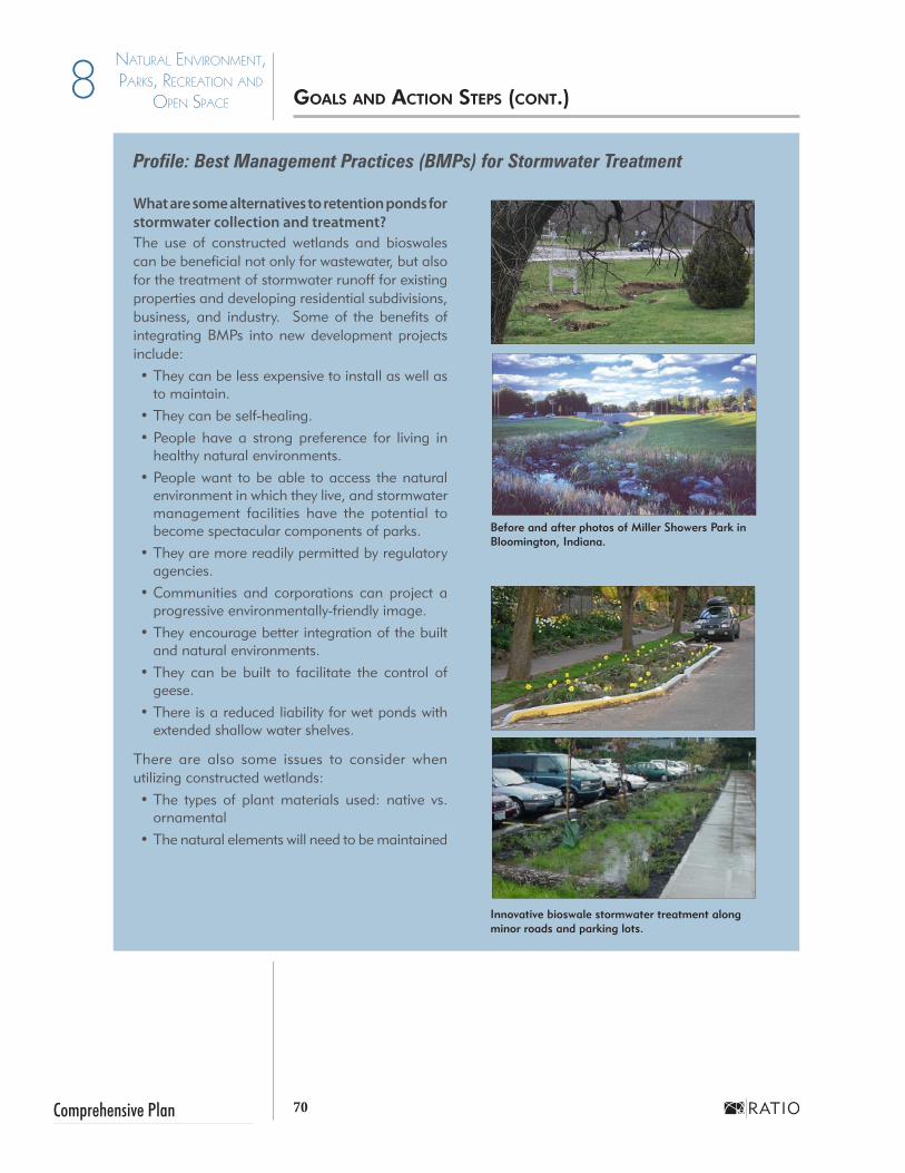
70Comprehensive Plan
8 Natural ENviroNmENt, Parks, rEcrEatioN aNd
oPEN sPacE
Profile: Best Management Practices (BMPs) for Stormwater Treatment
What are some alternatives to retention ponds for stormwater collection and treatment?The use of constructed wetlands and bioswales can be beneficial not only for wastewater, but also for the treatment of stormwater runoff for existing properties and developing residential subdivisions, business, and industry. Some of the benefits of integrating BMPs into new development projects include:•They can be less expensive to install as well as
to maintain.•They can be self-healing.•People have a strong preference for living in
healthy natural environments. •People want to be able to access the natural
environment in which they live, and stormwater management facilities have the potential to become spectacular components of parks.
•They are more readily permitted by regulatory agencies.
•Communities and corporations can project a progressive environmentally-friendly image.
•They encourage better integration of the built and natural environments.
•They can be built to facilitate the control of geese.
•There is a reduced liability for wet ponds with extended shallow water shelves.
There are also some issues to consider when utilizing constructed wetlands:•The types of plant materials used: native vs.
ornamental•The natural elements will need to be maintained
Before and after photos of Miller Showers Park in Bloomington, Indiana.
Innovative bioswale stormwater treatment along minor roads and parking lots.
gOAls AND ACTiON sTEPs (CONT.)

71 City of Plymouth
Natural ENviroNmENt, Parks, rEcrEatioN aNd
oPEN sPacE 8
JUNE 2013
Action Steps...
• Monitor environmentally sensitive natural features and assess the effects of potential development during the technical review of projects. This will allow the City to work more effectively with developers on site layouts sensitive to the environment.
• Plat retention areas as easements including a buffer of at least 15 feet at the top of bank for emergency access and maintenance. Do not allow people to build structures or fences in easements.
• Septic systems allowed in rural residential designated areas should ensure that proper soil testing is undertaken prior to construction.
• Create incentive programs to encourage developers and residents alike to manage stormwater on site, and through natural drainage systems such as vegetated swales and rain gardens.
• Consider an assessment on development in MS4 areas. Develop a targeted public outreach to educate citizens on the relationship between runoff and water quality.
• Update the Subdivision Control ordinance to require setbacks and other standards to conserve and protect sensitive natural features like wetlands, woodlands, heritage trees, and stream corridors.
• Work with the county surveyor on policies for managing river and stream corridors as environmental and recreational areas.
Goal Two: Remediation. Remediate potentially contaminated or damaged lands for environmental and economic benefits.
Policy 1 Pursue grants and other funding mechanisms to continue the removal of existing structures from the Yellow River floodplain.Many homes and other structures have been constructed in the floodplain of the Yellow River. Some have been removed, but a significant number still remain. These should be removed to allow for effective flood control in the river corridor.
Policy 2 Remediate environmentally contaminated sites within the City.Over the years, businesses come and go from the community, potentially leaving behind materials that could damage the environment. Pursue EPA Brownfield grant to clean up sites to ready sites for development. Many of these sites can be reused, but may be passed over due to uncertainty about their environmental status. These sites can be a low cost alternative to growth further away from the City if they are cleaned up.
Action Steps...
• Maintain a database of potentially contaminated sites and pursue grant funding for cleanup.
• Partner with developers to remediate environmentally contaminated sites with a defined incentive program.
gOAls AND ACTiON sTEPs (CONT.)
Stormwater best management practices include rain gardens and permeable pavement. Application of such techniques minimizes stormwater runoff.

72Comprehensive Plan
8 Natural ENviroNmENt, Parks, rEcrEatioN aNd
oPEN sPacE
Goal Three: Yellow River. Use the Yellow River as a tool to inspire community development.
Policy 1 Continue to acquire land along the riverfront for the purpose of converting it to parks and open space uses.The Yellow River is a key amenity for Plymouth. There are parks adjacent to the river. It is important to now focus on the links between the parks, the river and the community.
Policy 2 Utilize the attraction of the parks and recreation system to inspire redevelopment of portions Plymouth.Plymouth has an opportunity to use the new River Park to draw visitors to Downtown. Fill in the gap between the successful Michigan Street businesses and the new park with new urban residential development in the style of townhomes, lofts or other multifamily use. This is the type of housing option missing in the Plymouth market. Developing land between downtown and the river as a parks facility and connecting it to other areas of the community with a greenways trail would make downtown accessible to many people. In this way the park could become an activity generator for downtown establishments.
Action Steps
• Work with the county surveyor on policies for managing river and stream corridors as environmental and recreational areas.
• Connect town roads, paths and trails visibly and physically to the river. Orient new development both to downtown and river as much as possible.
• Utilize riparian corridors as amenity areas, trail locations, and natural preserves.
Goal Four: Enhancement. Enhance and maintain existing parks, and recreation and open space system.
Policy 1 Improve existing facilities at Centennial Park.Centennial Park is one of the most important public spaces in the community, hosting festivals and a number of other activities, most notably the annual Blueberry Festival. Its facilities are at an age where continued maintenance and upgrades are necessary. The City should work to make sure that this park remains a regionally significant recreation resource.
Policy 2 Maintain the hightened public awareness of the City’s parks and recreation facilities and programs.The parks and recreation system cannot be successful without the participation of the residents of Plymouth. A coordinated public information program regarding the facilities and activities offered by the City and other organizations would helps to maximize the involvement and support of the community.
Parks facilities and cultural events, such as the Blueberry Festival, are important parts of Plymouth’s quality of life. They play a central role in attracting new employers to the community as well as generating tourism, which helps local businesses.
M
arsh
all C
ount
y B
lueb
erry
Fes
tival
gOAls AND ACTiON sTEPs (CONT.)

73 City of Plymouth
Natural ENviroNmENt, Parks, rEcrEatioN aNd
oPEN sPacE 8
JUNE 2013
The Arthur W. Thompson bridge is one of many unique features found in Centennial Park.
Policy 3 Support urban forestry throughout Plymouth.A major part of Plymouth’s identity is established by the trees found throughout the community. This is most evident in the Michigan Street corridor on the south side of Plymouth. The City should expand the urban forest to other streets and public spaces with strategic tree plantings and management. For more information, review the Profile on page 79.
Action Steps...
• Coordinate the work of the Parks Foundation and other groups with special interests that support Kiddie Kingdom, tennis, dog park creation, amphitheater, and conservation clubhouse into one organization with a mission to raise funds for park and recreation related projects throughout the community.
• Continue regular updates as necessary for the 5-Year Parks and Recreation Master Plan to prioritize projects and funds. This also will enable the community to be eligible for IDNR Land and Water Conservation Fund Grants.
• Provide links to the Yellow River Festival, sports recreation programs and other events on City website and create Plymouth Parks Facebook page.
• The Urban Forestry and Flower Committee should work with the City Public Works Department to underplant existing mature tree canopies. This group shoud apply to becoming a Tree City USA and America in Bloom Community.
• Update the Subdivision Control to require open space in areas with significant growth and subdivision development that might necessitate additional park facilities.
Goal Five: Growth. Ensure that the parks system keeps pace with community growth.
Policy 1 Acquire new park land as development within the City occurs.Residential development has been slow within the City in the last decade as development has shifted to county lands. That development, in the county within Plymouth’s 2-mile planning jurisdiction, does not help support City parks. Those existing communities and new residential and commercial development in that area should provide opens space, trails and sidewalks that connect to City, river and regional trails. The added open space and trails would be owned and maintained by the Homeowner Associations (HOA) unless accepted for dedication by the County and City.
Policy 2 Continue cooperative efforts between the City and school system for parks and recreation opportunities.The City has developed a relationship with the school system for the mutual use resources for parks and recreation activities.
gOAls AND ACTiON sTEPs (CONT.)

74Comprehensive Plan
8 Natural ENviroNmENt, Parks, rEcrEatioN aNd
oPEN sPacE
PROFILE: WetlandsWhat is a Wetland?Wetlands are areas inundated or saturated by surface or ground water throughout the year. The presence of water at or near the surface is the dominant factor that determines soil characteristics as well as plant and animal communities.
Why are Wetlands Important?•Water Quality - Wetlands purify water by filtering and trapping sedi-
ment, chemicals, and excess nutrients before water enters other water bodies or groundwater.
•Wildlife Habitat - Wetlands provide habitat for fish, waterfowl, and other wildlife which use these areas to breed, find food, and protect their young.
• Flood Control - Wetlands reduce flood damages by storing and slow-ing floodwaters. Wetlands regulate water levels within a watershed.
How are Wetlands Identified?The general location of wetland areas may be determined using the U.S. Geological Service’s (USGS) National Wetland Inventory (NWI) maps. The specific identification of wetlands are typically made by an individual holding a “US Army Corps of Engineers Regulation 4 Jurisdictional Wetland Certification”. The exact boundaries of jurisdictional wetlands can be determined using all three of the following criteria:•Water Indicator - The area is inundated or saturated to the surface,
by a single, continuous episode, for at least 5% of the growing sea-son in most years.
•Wetland Vegetation - The presence of plant species that are typically adapted for life in anaerobic soil conditions.
•Hydric Soils - The presence of soil that is saturated, flooded, or ponded long enough during the growing season to develop anaerobic conditions in the root zone.
Who Regulates Wetlands?Wetlands along waterways are protected primarily by the U.S. Army Corps of Engineers (Corps) under Section 404 of the Clean Water Act. The Natural Resource Conservation Service (NRCS), U.S. Fish & Wildlife Service (USFWS), as well as state and local environmental agencies may also regulate wetlands.
The U.S. Environmental Protection Agency (EPA), Corps, and USFWS have a public policy of “no net loss of wetlands” requiring acre-for-acre replacement of wetlands either on-site or within the same watershed.
Significant wetlands exist within Plymouth’s planning jurisdiction.
gOAls AND ACTiON sTEPs (CONT.)
75 City of Plymouth
Natural ENviroNmENt, Parks, rEcrEatioN aNd
oPEN sPacE 8
JUNE 2013
gOAls AND ACTiON sTEPs (CONT.)
Profile: Riparian CorridorsRiparian areas are also known as streamside forests. They are the wooded areas along rivers and streams. These areas are a complex ecosystem vital to the protection of stream and river water quality. These areas include some of the richest varieties of plants and animals in most regions.
Why are Riparian Areas Important?Land along waterways has significant ecological and aesthetic value that enhances the natural environment of a community. The presence of riparian areas also adds value to properties with water access, as they are often prime locations for development.
Many communities depend upon local rivers and streams for recreation, drinking water, and natural resource areas. The loss of riparian areas along such waterways is a major cause of decreases in water quality and loss of wildlife habitat.
How are Riparian Areas Identified?Healthy riparian areas are typically composed of large trees, woody understory trees and shrubs, and smaller flowers, grasses, and ground covers. Well maintained and managed riparian areas are able to influence the physical, chemical, and biological characteristics of the stream by:
1. Providing food, shelter and natural linkages for a wide variety of plant and animal communities.
2. Shading and cooling the stream to enhance aquatic habitats.3. Filtering sediments and pollutants, preventing them from entering the
stream or waterway.4. Stabilizing river banks and reducing bank erosion.5. Providing flood control.
Who Regulates Riparian Areas?In Indiana, the Indiana Department of Natural Resources has the authority to regulate riparian areas for water quality purposes. Local governments may regulate, to some extent, development or encroachment to riparian areas through planning and zoning controls.
The Natural Resource Conservation Service (NRCS) has developed Conservation Standards for Riparian Forest Buffers (Code 391). These standards are site specific and will vary depending on the size of the waterway and floodplain. Most standards address an area ranging from 35 to 150 feet on either side of the stream.
The ideal riparian area includes three zones for management in which development should be restricted. These zones, listed in sequence from the edge of the stream, are as follows:• Undisturbed Forest - This zone is adjacent to the stream and is ideally
15’ in width. Removal of vegetation is not permitted.•Managed Forest - This zone is ideally 60’ in width and harvesting of
older vegetation is encouraged to support better filtering/removal of nutrients through younger, faster growing vegetation.
• Runoff Control - This zone is ideally 20’ and may be pastured, farmed for hay or mowed for recreational purposes.

76Comprehensive Plan
8 Natural ENviroNmENt, Parks, rEcrEatioN aNd
oPEN sPacE
Policy 3 Require easements along creek corridors as a component of new development.A reality of growth is that once land is developed, it is highly unlikely that it can be reclaimed to become a park. It is important that the City be proactive in securing trail and greenway easements during platting so that opportunities are not lost to continued development.
Policy 4 Develop a system of bicycle and hiking trails within the City.Greenways trails provide transportation and recreation benefits, and have been immensely successful in Plymouth and other communities so the City should seek to expand the system beyond the original corridor. It is important that a trail system connect important community resources such as Downtown, parks, schools, and residential areas.
Policy 5 Update the Community Pool or Provide other Water RecreationSwimming pools, spraygrounds and other recreational park water features and big draws for residents and visitors. There is a desire to update or replace the pool in Centennial Park.
Action Steps...
• The City should focus on maintaining and enhancing parks within the corporate limits
• Develop a bicycle and pedestrian connectivity plan as part of the Subdivision Control Ordinance.
• Develop stormwater credits to entice developers to provide natural and park amenities.
• Consider “adopt a park” programs to assist with maintenance and funding.
• Complete a needs assessment as part of the 5-Year Park and Recreation Master Plan. Because there has been little City population growth in the last decade, additional park space may not be needed and the focus should be shifted to maintenance.
• The City should undertake a Pool Feasibility Study to assess demand, types of facilities, service requirements and shorth and long term costs. This information should then be incorporated intoan update of the 5-Year Park and Recreation Master Plan, the Parks Board Plan and the Capital Improvements Plan.
Park water feature in Zionsville, IN.
Conservation Clubhouse constructed under the Works Public Administration (WPA), 1930’s.
gOAls AND ACTiON sTEPs (CONT.)

77 City of Plymouth
Natural ENviroNmENt, Parks, rEcrEatioN aNd
oPEN sPacE 8
JUNE 2013
gOAls AND ACTiON sTEPs (CONT.)
PROFILE: Urban ForestryTrees can provide a number of benefits to a community. However, the species, design, location, and maintenance of trees must be carefully considered to ensure their health and vitality. For example, using continuous planting beds can be beneficial for the health of trees, and close attention should be paid to tree species and planting locations. The “10-20-30 Rule” described below outlines some of the considerations to take into account when planting trees within an urban setting.
The 10-20-30 RuleThis general rule for urban tree planting includes:• Plant no more than 10 percent of any species.• Plant no more than 20 percent of any genus.• Plant no more than 30 percent of any family.
This rule, if followed, helps to prevent monocultures. When too many of one tree type are planted in close proximity to each other, a disease or aggressive pest in one can quickly spread to all others, sometimes resulting in their necessary removal and subsequent lack of trees in a previously landscaped area.
For example, the Emerald Ash Borer, an aggressive pest, is currently causing the removal of Ash trees throughout the state and region. Many other pests and diseases are being identified throughout the Midwest, and could affect central Indiana’s trees in the coming years or decades, including:• Asian Long Horned Beetle - affects Maples• 10 Canker Disease - affects Walnuts•Oak Wilt - affects Oaks• Calico Scale - affects Honey Locust• Red Maple Chlorosis - affects over-planted Red Maples• Cracks in tree trunks - affects Bowhall Maples•Needlecast - affects Spruces
By reducing the potential for a monoculture of intentionally planted trees, it will be easier to plan for their replacements, should the need occur.

78Comprehensive Plan
8 Natural ENviroNmENt, Parks, rEcrEatioN aNd
oPEN sPacE
Page left intentionally blank.

City of PlymouthJUNE 2013
Public Services & Infrastructure SECTION I - Goals & Action Steps 9

80Comprehensive Plan
9 Public ServiceS & infraStructure
Infrastructure and public services work together as a system to provide Plymouth with operational essentials for health, safety and economic success. Those essentials include safe and accessible street systems, the water supply, stormwater, solid waste, recycling and sewer facilities. The public services citizens depend on include fire, police, schools, libraries, parks and municipal facilities. Each of these components requires careful planning in order to maximize their performance and the resulting benefits to the community. The condition and capacity of community infrastructure will greatly influence the patterns of growth.
In recent years, many subdivisions have been developed just outside the City limits. This presents a challenge to the City’s capacity for providing vital public services including sewers, water, street systems, public safety, schools and social services. In addition, these subdivisions are not connected to City utilities, which means that annexing them would require a substantial investment on the part of the City. This situation is not sustainable for decades to come.
New development of any intensity on parcels less than 5 acres must require extension of water and sewer utilities to serve their needs. Plymouth should strategically annex land to provide for new development. In that respect, infrastructure investments, including those for roads, must be carefully considered in order to avoid enabling problematic development patterns.
One of Plymouth’s water towers, located in an industrial park.
Planted greenspace provides a buffer between sidewalks and busy streets
iNTrODUCTiON TO PUbliC sErviCEs AND iNfrAsTrUCTUrE

81 City of Plymouth
9Public ServiceS & infraStructure
JUNE 2013
Goal One: Community Development. Provide for well-planned and orderly growth of the community through strategic annexations and sustainable policies.
Policy 1 Work with the county to prohibit new development without City utilities.Many developments outside Plymouth Corporate Limits have been developed without City water and sewer services. Requiring large-scale residential development to be served with public sewer and water utilities would enable the City to grow through annexation (see example in right).
Policy 2 Require land to be annexed in order to connect to City utility services.By requiring land to be annexed before receiving water and sewer services, any growth that occurs will take place contiguous to the existing community. New development will be immediately added to the city’s tax base, providing an equitable collection of taxes and helping to fund important city services.
Policy 3 As annexation occurs, evaluate the need to expand the “two-mile fringe” area surrounding the city.The city currently plans in the area approximately two miles outside of its corporate limits (permitted by state law) also known as the extraterritorial jurisdiction (ETJ). As the city annexes new parcels, the city should evaluate the need to adjust the ETJ. It may make sense to only expand the jurisdiction to roads or geographical boundaries that are strategic for the city’s near term goals and to return outlying parcels to the County to plan for development.
Policy 4 Use the Land Use Plan as a guide for utility investment.Maintenance and expansion of the utility system must be carefully planned in order to serve existing customers while providing for appropriate growth within the Corporate Boundaries. The extension of utilities to cover failing systems shall require annexation into the City without remonstrance. An alternative is to create septic owner districts to deal with future issues is described in the “Profile” on the following page.
Policy 5 Use the Future Land Use Plan as a guide for utility investment.The Future Land Use Plan found in Chapter 11 of this document constitutes the established vision for growth in Plymouth via annexation. Utility investment decisions should be evaluated and coordinated with those areas in mind.
Action Steps...
• Study the feasibility of maintaining, expanding, or contracting the 2-Mile Fringe, over which it exercises planning and zoning authority. Any changes to the fringe area require approval from the Marshall County Commissioners, so close coordination with county officials is essential. The City may want to consider hiring a consultant to prepare a opportunities plan to look at the fiscal and tax ramifications of annexation and or expanding or contracting the fringe area.
Major subdivisions are defined in the Plymouth Subdivision Control Ordinances as more than 6 lots.
gOAls AND ACTiON sTEPs

82Comprehensive Plan
9 Public ServiceS & infraStructure
PROFILE: Addressing Failing Septic Systems
Communities that are faced with limited utility capacity, especially for water and wastewater treatment, sometimes permit development that utilizes septic systems (wastewater treatment facilities that consist primarily of a septic tank and a soil absorption field) for wastewater treatment. This can result in development patterns that are decentralized and physically separated from the municipality by undeveloped and agricultural land. Over time, challenges can arise as some septic systems, which have life spans of multiple decades unless improperly installed or maintained, begin to fail.
In these situations a municipality’s first response may be to try to extend public treatment utilities into these areas. This can be very costly for both the municipality and the homeowner.
Below are some guidelines and recommendations regarding septic system usage:• Carefully review the circumstances that exist when proposals are
made for new residential subdivisions. Septic systems typically need a large quantity of space to function properly, and residential subdivi-sions that are too dense may increase the chance of system failure.
• If systems do begin to fail, or are showing signs of wear:• Consider offering incentives or technical assistance to
home owners to replace systems• Create a municipal septic management district or simi-
lar agency to assist homeowners with repairs, replace-ments, and maintenance of systems for a fee similar to that of centralized municipal utility users
For further information on the subject, refer to the document Essential Smart Growth Fixes for Rural Planning, Zoning, and Development Codes (PDF) (www.epa.gov/smartgrowth/essential_fixes.htm).
Portions of this profile adapted from “Rural Water Infrastructure Planning”. Planning Magazine. August/September 2012.
• As development is considered in likely growth areas west and north of the City or east to the County Farm, the utility master plan should provide guidance to the developers and work with them to provide adequate, modern service. Holding strong to policies to provide utilities or roads to annexed areas is crucial and will result in a desirable and sustainable development pattern.
• Continue to engage a professional planner at least part time skilled in both municipal long range and current planning.
gOAls AND ACTiON sTEPs (CONT.)

83 City of Plymouth
9Public ServiceS & infraStructure
JUNE 2013
Plymouth’s Fire Department provides protection to the entire community and also coordinates services with Center and West Townships.
Goal Two: Utility Public Services and Investment. Support the community’s land use objectives, utilities investments and policies.
Policy 1 Enhance the city’s relationship with Plymouth Community Schools. Schools are a key service in any community, and high-quality schools can make a community a desirable place for families to live. The relationship between schools and growth must be recognized and addressed in a joint effort between the city and the school system. It is important that schools remain neighborhood-based when feasible, as this will allow more students to walk to school and reduce transportation impacts. Sidewalks and multi-use paths must be an integral part of development.
Policy 2 Ensure the safety of the community’s drinking water. Plymouth draws drinking water from a number of wells located at the two water treatment facilities owned by the city. It is important that the ground water systems that feed these wells remain free of pollutants and other contamination.
Policy 3 Maintain adequate capacity in the City’s sewer and water systems.Provision of sewer and water systems is one of the most essential roles that city government plays in the lives of its citizens. Therefore, it is important that the capacity and efficiency of those services be carefully monitored to ensure that all users are being served effectively and healthfully.
Policy 4 Support the continued addition of capacity for the City’s public safety services.Fire and police protection are among the most vital services provided by a community. During City technical review of proposed development the needs for facilities and personnel to protect the community should be assessed. Of particular note is the need to establish a second fire station in the western sector of the City, in order to increase service coverage and reduce response times.
Policy 5 Facilitate the coordination of planning services with Marshall County.The city and the county can both benefit through the careful coordination of their growth and development policies. In addition, it may be prudent to combine the staffs of the two planning departments to facilitate this coordination, as well as to get the most benefit out of the limited fiscal resources available to both jurisdictions for planning.
gOAls AND ACTiON sTEPs (CONT.)

84Comprehensive Plan
9 Public ServiceS & infraStructure
See the Capital Improvement Plan Profile on page 85 for further
information.
Action Steps...
• Convey the importance to and educate the development community, county and residents of requiring connection to municipal utilities (water and sewer) upon annexation prior to development plan application and submittal for Technical Review.
• Upgrade 4” and 6” lines to 8, 10 or 12” of sewer and force main extensions to increase capacity of proposed utilities to serve existing areas to allow for growth and adequate delivery. Consider partnering with existing large users and developers to share the cost and speed upgrades.
• Maintain the inter-local agreements to help fund fire protection.
• Utilize the Water & Sewer Master Plan to identify critical corridors that could be used for easements and then secure them during the development approval process
• Establish a second fire station in the western sector of the City (likely growth area), in order to increase service coverage and reduce response times.
• Evaluate the need for a fire safety training facility in Plymouth vs. sharing the Warsaw facility
• Resolve volume and pressure issues in the vicinity of Richter Road with new tower and larger service lines.
• Keep existing or locate new municipal facilities in the city center to catalyze develop and investment in that area
• Continue to stencil signs on inlets and drains that caution against improper disposal of hazardous materials (motor oils), herbicides, fertilizer that affect the health of the Yellow River
• Continue to utilize a 5-year Capital Improvements Plan (CIP) to identify, organize and prioritize projects and funding sources over a period of several years. Recommendations in this comprehensive plan may serve as a foundation for a CIP. The CIP should be reviewed and updated annually. A cost/benefit analysis should be undertaken as part of the CIP plan process.
• Continue to update a wellhead protection overlay district as a component of the zoning ordinance. Increase awareness by publicizing the impacts that residents and businesses can have on water quality.
Goal Three: Coordination. Coordinate with other local, regional and state jurisdictions to ensure that community infrastructure needs are met.
Policy 1 Coordinate with the Indiana Department of Transportation to preserve community access to U.S. 31 after planned improvements.As the State plans for upgrades to the U.S. 31 corridor through Marshall County, there is potential for it to become a limited access freeway. It is important that Plymouth work constructively with the state during this process to make sure that the resulting project achieves both community and state goals.
gOAls AND ACTiON sTEPs (CONT.)

85 City of Plymouth
9Public ServiceS & infraStructure
JUNE 2013
PROFILE: Capital Improvements Plan What are Capital Improvements? Capital improvements refer to major public projects such as the construction and maintenance of roads, sewers, sidewalks and municipal buildings and the acquisition of property and equipment. In short, it is public investment in the necessary infrastructure to serve current and future residents and businesses.
What is a Capital Improvement Plan (CIP)? A Capital Improvement Plan (CIP) is a timetable identifying all planned capital improvements typically for a 5-year period of time. Year one corresponds to the operating capital budget for the next fiscal year. Years two through five outline a timetable for future projects. However, the municipality is not obligated to spend funds on any of the projects listed in years two through five.
Why is a CIP Budgeted? A capital improvement budget is legally adopted in the operating budget. Each year city department heads and other staff review the list of future improvements and makes minor adjustments to the plan as needed. Projects are prioritized by importance, given an approximate completion date and cost estimate, and listed with anticipated funding sources. Although the City of Plymouth currently requires each department head to develop individual CIP’s, there is no official city-wide CIP shared across departments.
Why is a CIP Important? A CIP gives Plymouth a clear, implementation strategy for enhancing its facilities and services. The plan also provides an effective means for matching municipal infrastructure needs with funding sources. With a CIP in place, the City can decide where and when growth occurs. For instance, growth is less likely to occur in areas without infrastructure, but the CIP can also spur growth by strategically extending infrastructure. Benefits of a Capital Improvement Plan include:• Long range financial planning• An opportunity to purchase land before prices become inflated• Implementation of long term projects in a coordinated and timely man-
ner• Reduction of costly mistakes such as tearing up a recently resurfaced or
new street to install utilities• Effective management of ratepayer/taxpayer dollars
How does a CIP relate to planned growth? With a CIP in place, the city can decide where and when growth occurs. For instance, growth is less likely to occur in areas without infrastructure. The CIP can also spur growth by extending infrastructure. Potential developers of these areas may ask the City of Plymouth to construct the infrastructure. When this request is denied based on the CIP, the developers may often offer to build the infrastructure. City officials may decide to approve the proposed development if it is consistent with the goals and objectives in this Comprehensive Plan, and if the infrastructure plans pass the City Engineer’s inspection. In this situation, the developer could agree to pay for the infrastructure, install it to city specifications, and deed it to the City upon completion. City specifications for the infrastructure should reflect the future demand for capacity.
gOAls AND ACTiON sTEPs (CONT.)

86Comprehensive Plan
9 Public ServiceS & infraStructure
Policy 2 Add amenities to Pioneer Road on the west side of Plymouth.The newly constructed north-south extension of Pioneer Road south to State Road 17 provides relief from congestion along the Michigan Street corridor and is intended to serve as a direct conduit to available land for light industrial business park, multifamily housing, and neighborhood commercial uses. To that end, utilities, pedestrian amenities such as lighting and sidewalks and street trees need to be provided as part of the basic infrastructure.
Policy 3 Work with the Indiana Department of Transportation to improve safety along U.S. 30 through Plymouth.As development around the U.S. 30 corridor continues, more traffic will be utilizing the highway. Additional points of access should be minimized and improvements to existing intersections should be made to ensure that motorists can utilize the corridor safely. The development of a frontage road system would also be beneficial. In the longer term, this may involve converting the corridor to a limited access highway.
Policy 4 Coordinate utility extension policy with Marshall County.Plymouth and Marshall County must work together to enable the type of growth pattern that will meet the goals of both communities. By mutually supporting growth that is contiguous to the City, that is annexed into Plymouth, and that is served by city utilities, agricultural and natural areas can be preserved and Plymouth’s tax base can be enhanced.
Policy 5 Continue active participation in regional planning, specifically through involvement with MACOG.The issues of traffic congestion and its relationship to growth are not limited to Plymouth’s city boundaries. Rather, these issues must also be addressed on a regional scale to be addressed effectively. Plymouth’s continued participation with the Michiana Area Council of Governments will ensure that it receives appropriate resources to address its transportation needs.
Action Steps...
• Develop a set of corridor design standards to convey to INDOT for the US 31 Corridor project. The planned interchange at US 31 and 7A Road is an opportunity for a north gateway as identified on page 84 of this plan. Consider including landscaping, art, signage or some other marker to increase awareness that one has arrived in Plymouth and that it is a “place” to stop.
• Work with INDOT to ensure that any new road improvements or renovations to the U.S. 30, U.S. 31 and S.R. 17 corridors consider gateways, lighting, signage, landscaping and access management methods for the character enhancement safety, and economic development success for Plymouth.
• The Historic Crossroads intersection at Jefferson and Michigan Streets should be highlighted in such a way to celebrate history and showcase the important vehicular and pedestrian connector that it is. This should be done in coordination with a review of appropriate building forms and edges for an intersection at the heart of the City.
Goals and Action Steps (cont.)

City of PlymouthJUNE 2013
TransportationSECTION I - Goals & Action Steps 10

88Comprehensive Plan
10 TransporTaTion
Residents of Plymouth rely on the transportation network to move from home to jobs, shopping, and recreation. A well planned, efficient system is a mark of a well planned community. The street right-of-way is a large part of the public realm. The components that occur within the right-of-way curbs, drainage systems, sidewalks, street trees, signage, and lighting, all contribute to the image and identity of a community or can be a deterrent. Along with utilities, streets are one of the major determinants of growth and is intimately connected to land use. Throughout the process, we heard residents and stakeholder express strong support for sidewalks, trails and greenways which are addressed in the multimodal transportation section beginning on Page 128.
Related Agencies and Regional PartnersTransportation planning does not occur in a vacuum. It is prudent to be aware of and participate in other planning efforts that may affect Plymouth’s decisions. This is especially relevant since transportation itself is regional by nature: people and goods move through the transportation system as it crosses through and connects with other jurisdictions. Thus local transportation is affected by programs and decisions beyond its own boundaries.
Marshall CountyThe Transportation Plan for Marshall County is based on the INDOT Functional Classification Map for roadways was reviewed to ensure consistency with the proposed street, roadway, rail, and trail improvements for Plymouth.
Michiana Area Council of GovernmentsMACOG is charged with providing a balanced transportation system and quality of life in the northern Indiana region where the needs of pedestrians, bicyclists, transit users and automobile operators are valued equally. The Marshall Countywide 2035 Transportation Plan is to be released during the 2013 calendar year. State, County, and City long term transportation assessments are also included within this document. This plan should always be consulted when reviewing any development (residential, commercial, industrial) proposals.
Indiana Department of Transportation
INDOT is another agency partner. INDOT’s planning efforts are concentrated on federal and state funded major thoroughfares that pass through and around Plymouth. INDOT develops the Indiana Statewide Transportation Improvement Plan (INSTIP) and the INDOT Long Range Transportation Plan (INLRTP) as addressing major corridors such as US 31 and US 30. SR 17 is also an INDOT controlled roadway.
Rail and Air
The CSX and Nofolk Southern Railroads are important transportation partners that can impact the success of economic development by broadening opportunities. The Plymouth and South Bend Regional Airport (30 minutes north) also enhance the options for connection of people and goods in the global economy.
iNTrODUCTiON TO TrANsPOrTATiON

89 City of Plymouth
10TransporTaTion
JUNE 2013
Goal One: Strengthen Local and Regional Connectivity. Ensure that new street systems provide links between destinations within and outside the City in a safe and effective manner. Policy 1 Reference the Thoroughfare Plan
Refer to the Thoroughfare Plan (Chapter 13) when coordinating planning efforts for community development or other improvements regarding the network of streets, sidewalks and multi-use trails.
Policy 2 Work with the Indiana Department of Transportation to improve safety along U.S. 30 through Plymouth.As development around the U.S. 30 corridor continues, more traffic will be utilizing the highway. Access should be controlled and improvements to existing intersections should be made to ensure that motorists can utilize the corridor safely. The development of a frontage road system would also be beneficial. In the longer term, this may involve converting the corridor to a limited access highway
Arterial roadways, such as U.S. 30 and 31, are intended to provide large volumes of traffic with a smooth, uninterrupted flow between communities. As the number of intersections, traffic lights, and other interruptions increase, so does the potential for congestion and accidents. It is important that access be strongly limited along these roadways, and removed in some cases where safety is a prime concern.
Policy 3 Create a system of designated truck routes through the community to serve the industrial parks and increase traffic safety.It is often difficult for large trucks carrying freight for local industries to coexist safely and efficiently with other traffic in the community. Provide designated routes such as Pioneer Road, U.S. 30, Oak Street and Jefferson Street/ Lincoln Highway west of Oak. Upgrade these facilities accordingly, including adequate turning radii for large trucks and durable surface materials. Consider relocating industrial and manufacturing concerns from the City center to reduce the need for truck traffic in that area. See the Future Land Use Map on page 101.
Policy 4 Facilitate systematic improvements to enhance the performance of existing roads. Efficiency and safety can be improved without major investment in new roads. Smaller systematic improvements can provide relief. Potential enhancements could include creating a center turn lane along portions of Jefferson Street, the use of round-a-bouts, changes in signalization, and consolidation of curb cuts to ease congestion.
Policy 5 Require vehicular and pedestrian connectivity between subdivisions.Encourage multiple points of access and reduce the use of cul-de-sacs for subdivision development to reduce congestion, promote community, and increase public safety response times.
The intersection of Jefferson and Michigan Streets is one of several congestion points in Plymouth
See the Access Management Profile on Page 90.
gOAls AND ACTiON sTEPs

90Comprehensive Plan
10 TransporTaTion
PROFILE: Access ManagementINDOT’s Access Management Guide1 defines access management as
“a set of proven techniques that can help reduce traffic congestion, reduce the frequency of crashes, maintain the existing roadway capacity, and preserve investment in roads by managing the location, design and type of access to property. By preserving the flow of traffic and improving traffic safety, access management helps to encourage economic growth.”
As traffic volumes on roadways increase, the need to control access from abutting properties also increases. The primary purpose of arterials, such as US 30 and 31, and major collectors, such as Jefferson and Michigan Streets, is to move traffic from one point to another, not to
provide access to individual properties. It is in the Town’s best interest to establish site development standards that minimize transportation impacts and ensures the safety and efficiency of the roadways. Access to these and other major thoroughfares in Plymouth should adhere to a local Access Management Plan, influenced by INDOT’s “Access Management Guide”
(http://www.in.gov/indot/2512.htm).
Some techniques to manage access are provided below.• Promote individual access via the local street system instead of on roads with arterial and collector
classifications.• Regulate minimum spacing of driveways.• Regulate the maximum number of driveways per property frontage.• Regulate minimum corner clearance and provide drivers suitable
sight distance to execute turns smoothly and safely.• For development on major thoroughfares, encourage cross-access
easements and, as appropriate, the use of frontage roads, shared driveways, and shared parking. Also require adequate internal circu-lation planning and design.
• Arrange access points so that streets and driveways are immediately across from one another.
• Place and space traffic signals to favor through-traffic on high-vol-ume roadways.
• Remove turning vehicles from through-traffic lanes utilizing medians to restrict left-turn movements and/or grade separation of the major thoroughfare and intersecting roadways.
• Coordinate with other governing agencies, such as INDOT, regarding development.
1. Access Management Guide, Indiana Department of Transportation, 2009
Examples of development employing access management principles for public streets and cross-access drives between uses.
gOAls AND ACTiON sTEPs (CONT.)

91 City of Plymouth
10TransporTaTion
JUNE 2013
PROFILE: RoundaboutsA roundabout is a circular intersection within which traffic maneuvers around the circle in a counterclockwise direction, and then turns right onto the desired street. All traffic yields to vehicles in the roundabout and left-turn movements are eliminated. Unlike a signalized intersection, vehicles generally flow and merge through the roundabout from each approaching street without having to stop.
Roundabouts reduce the number of potential conflict points, compared with traditional intersections. Experience has demonstrated that vehicular crashes are significantly reduced when low-speed, single lane roundabouts replace four-way intersections.
Proper accommodation of pedestrians and bicyclists in roundabouts represents an area of continuing research and development. Properly designed roundabouts include sufficient deflection to ensure low speeds, and splitter islands at the approaches slow vehicles and allow pedestrians to cross one direction of travel at a time. The literature shows that, given a properly designed single-lane roundabout, motorist and pedestrian safety is almost always improved when compared to conventional intersections. Multilane approaches can create additional points of conflict for pedestrians.
The splitter islands at roundabouts allow pedestrians to cross one direction of traffic at a time. This is a significant advantage over conventional intersections. If motorists do not yield to pedestrians at the crosswalk, pedestrians must select a gap in traffic before crossing. If traffic flow is continuous, choosing a gap may become problematic.
Wayfinding and gap selection cues need to be adequately addressed in the design of roundabouts so that roundabouts are not a barrier to pedestrians that are visually impaired.
Roundabouts can be challenging for cyclists, therefore in larger roundabouts, an off-road bicycle path may be necessary to allow cyclists to use the pedestrian route.1
1 Pedestrian and Bicycle Information Center. Funded by US FHWA.
http://www.walkinginfo.org/engineering/roadway-roundabouts.cfm
Roundabouts provide alternatives to intersection signalization.
gOAls AND ACTiON sTEPs (CONT.)

92Comprehensive Plan
10 TransporTaTion
Policy 6 Encourage mixed land use patterns.Residential areas are not in close proximity to areas of employment which requires vehicle travel between most destinations. Appropriate integration of compatible uses would reduce the number of trips that Plymouth residents would have to make, which would help to reduce traffic volumes in the community.
Policy 7 Consider all modes of transportation when evaluating the street system.To create a truly efficient and inclusive “walkable” system, pedestrian and bicycle mobility must be a component of every development proposal. This includes providing sidewalks and incorporating bicycle facilities for new roads and retrofitting existing systems when undergoing streetscape or road function improvements.
Policy 8 Support efforts to enhance air travel to Plymouth and Marshall County.Promote the convenience of the Plymouth Airport to corporations and industries based in the City and the County that can utilize the facility for flights or air-related uses.
Policy 9 Support efforts to strengthen rail access.Rail service remains an important part of Plymouth’s industrial base. The City should continue to encourage industries that can fully capitalize on rail access to/from the City.
Action Steps...
• Continue to review and update the 5-year Capital Improvement Plan (CIP) for use by municipal departments, boards and commissions to identify, prioritize and fund projects related to public services and facilities.
• Continue to update the City of Plymouth Standard Specifications manual to include engineering standards for new roadway projects (pavement width, apron design, subsurface and installation details, etc.).
• Most importantly, UPDATE the Subdivision Control Ordinance to guide the layout and development of commercial, industrial and residential subdivisions, including block layout, access standards, roadway type, the use and length of cul-de-sacs, provision of multi-use paths, sidewalks, bike facilities, streetlights, landscaped buffers and curb and gutter standards.
• Implement access management policies for U.S. 30, U.S. 31, Michigan and Jefferson Streets which include no additional curb cuts, shared access/driveways, and cross-access easements between parcels.
• Strengthen east-west connections such as Jefferson Street. Conduct a traffic study to provide a roundabout at Pioneer Road to facilitate movement where future development is anticipated.
• Comply with the standards and cross-sections in this plan that acknowledge the importance of complete streets and provides space for bicycles and pedestrians with the travel ways.
• Celebrate the historic transportation Crossroads Corridors that bisect Plymouth: Lincoln Highway, Michigan Road, Dixie Highway, Yellowstone Trail. Use public art, markers, signage or special materials to highlight the routes.
gOAls AND ACTiON sTEPs (CONT.)

93 City of Plymouth
10TransporTaTion
JUNE 2013
Goal Two: Alternative Transportation. Enhance multi-modal transportation infrastructure.
Policy 1 Require the construction of sidewalks in all new development.Sidewalks are an essential component of all new development, regardless of the land use. Providing sidewalks enhances safety, provides an alternative to driving, and makes more areas of the community accessible for people without personal vehicles. It is also an important amenity for neighborhoods and commercial areas.
Policy 2 Support the development of a greenways trail system connecting important destinations within the community and regionallyPlymouth has been creating a greenways trail to serve the Yellow River corridor. This should be the first step in a long term plan to provide multiple trails along rail corridors and creeks and to expand that along the river.
Policy 3 Require the provision of bicycle parking facilities as a component of new commercial and multifamily developmentIn order for people to bicycle to shop or work, there must be a safe place to store their bicycle once they arrive. An easy way to provide this is to require, as a part of the zoning ordinance, that new employment, commercial and multifamily establishments provide a minimum number of bicycle racks for customers, employees, and residents.
Policy 4 Continue to implement the ADA Transition Plan Provide sidewalks of adequate width, without obstruction and with ramps to transition to streets as designated in the plan. In addition address gaps and deficiencies in the current sidewalk network in other areas to facilitate connections between different parts of the city, retail areas and neighborhoods and schools.
Policy 5 Consider a fixed-route transit circulators to common destinations in PlymouthDiscuss the possibility of working with MACOG to study demand to expand the Rock City Rider on-demand service to a fixed-route circulator. The current system is not age restricted, operates between 7:00am - 5:30 pm and conveys riders up to $5 miles for just $2.
gOAls AND ACTiON sTEPs (CONT.)
Trails are an asset to community connectivity and promote an active lifestyle

94Comprehensive Plan
10 TransporTaTion
Profile: Walkable CommunitiesThe following characteristics are the qualities found in urban places where development pattern, intensity and design character combine to make frequent walking and transit use attractive and efficient choices for many people, as well as provide for automobiles and convenient and accessible parking.
1. Mixed land uses in close proximity to one another2. Building entries that front directly onto the street without parking
between entries and the public right-of-way3. Building, landscape and thoroughfare design that is pedestrian-scale
-- it provides architectural and urban design detail with size and design appreciated by persons who are traveling slowly and observing from the street level
4. Relatively compact developments (both residential and commercial)5. A highly-connected, multimodal circulation network, usually with a
fine “grain” created by relatively small blocks6. Thoroughfares and other public spaces that contribute to
“placemaking” -- the creation of unique locations that are compact, mixed-use and pedestrian- and transit-oriented and have a strong civic character with lasting economic value
An increasing number of communities are recognizing the value of these features and are embracing them in land use, urban design and transportation plans, often using techniques drawn from planning and design movements such as smart growth and new urbanism.
Source: Context Sensitive Solutions in Designing Major Urban Thoroughfares for Walkable Communities; An ITE Proposed Recommended Practice. 2006.
gOAls AND ACTiON sTEPs (CONT.)

95 City of Plymouth
10TransporTaTion
JUNE 2013
Action Steps...
• UPDATE the Subdivision Control Ordinance to require sidewalks and multiuse paths in new residential, commercial and industrial developments to some extent.
• Ensure that new or improved roads match the recommendations in the Thoroughfare Plan such as road facilities providing the required amount of right-of-way to accommodate vehicles, bikes and pedestrians and street trees.
• Continue to appropriate funds in the CIP to implement the City’s Adopted ADA transition plan (Refer to ADA Transitions Plan Profile on Page 92).
• Maintain a Sidewalk Improvement Plan in addition to the ADA Transition Plan. Document the needs and accomplishment on a GIS layer. These products will influence the prioritization of improvements in the CIP and will assist in seeking grant funding such as from the Safe Routes to School program. Establish an escrow fund for sidewalks that developers can contribute to in lieu of providing required sidewalk on subject properties at the time of development in special circumstances, not as a matter of course.
• Actively pursue easements along creeks, the river, adjacent and in agricultural areas in order to implement a continuous greenway corridor.
Goal Three: Image Enhancement. Utilize the transportation network to promote a positive community image.
Policy 1 Promote Attractive New StreetscapesPartner with relevant stakeholders such as INDOT, Marshall County, and the Urban Forestry and Flower Committee to create attractive public rights-of-way utilizing street trees, signage, lighting, landscaping, or similar treatments.
Policy 2 Encourage Public Interaction with Natural SystemsDesign and/or locate public ways to encourage access to natural areas or resources. Promote environmentally-sensitive development. Consider the use of sustainable materials, landscaping, or construction practices that not only have the least impact on natural systems, but also highlight or celebrate such features.
Action Steps...
• Enhance Gateways for gateway community entrances at key locations along thoroughfares at the edges of the City.
• Celebrate the fact that Plymouth is a Tree City USA and American Bloom Community. Prepare signage, sponsor events, involve service organizations of both older and younger citizens.
gOAls AND ACTiON sTEPs (CONT.)
Sidewalks in and along natural amenities lend to an attractive community image.
96Comprehensive Plan
10 TransporTaTion
PROFILE: Americans with Disabilities Act (ADA) - Transition PlansPurposeAn ADA Transition Plan is a set of goals, methods and procedures to bring the public agency’s facilities into compliance with ADA. These facilities include all buildings and public right-of-ways. ADA Transition Plans have been a requirement of public agencies since the codification of the Americans with Disabilities Act (ADA) of 1990, although transition plans were a requirement for some entities through Section 504 of the Rehabilitation Act of 1973. Transition Plans were originally to be completed in 1992 for these public agencies per the original Act, although new emphasis on the needs and requirements of this legislation appear to be prevalent.
The City has an adopted ADA Transition Plan and has , designated an ADA Coordinator, provided notice to the public about ADA requirements, and establish a grievance procedure.
Next on the agenda is to:
Develop internal design standards, specifications, and details,
Assign personnel for the development of a Transition Plan and completing it,
Approve a schedule and budget for the Transition Plan, and
Monitor the progress on the implementation of the Transition Plan.1
The above guide also lists specific suggested elements for a Transition Plan:
Develop a list of physical barriers in the agency’s facilities that limit accessibility of individuals with disabilities (Self-evaluation),
Include a detailed description of the methods to remove these barriers and make the facilities accessible,
Prioritize a schedule for taking the necessary steps,
Name the official responsible for implementation,
Plan a schedule for providing curb ramps, and
Record the opportunity given to the disability community and other interested parties to participate in the development of the plan.
Plymouth should actively consider and review the requirements of the Act and move to incorporate these into the 5-Year Capital Improvements Plan (CIP). It should be noted that periodic updates to the Plan are required in order that on-going compliance is continued. Self-evaluation checklists are available to assist in the plan development.
Although funding is generally to be programmed as a part of planned projects, other sources are available as well. These include federal funding through the MPO using many of their standard programs, such as: the Congestion Mitigation/Air Quality Program, the Highway Safety Improvement Program, the Railway–Highway Crossing Program, Recreational Trail Program, the Safe Routes to School Program, State & Community Traffic Safety Program, the Surface Transportation Program, and the Transportation Enhancement Activities Program. 1
For additional information about the Transition Plan refer to the web page “Questions and Answers About ADA/Section 504” at: http://www.fhwa.dot.gov/civilrights/programs/ada_sect504qa.htm#q
1 ADA Transition Plans: A Guide to Best Management Practices, The National Academies, National Academy of Sciences, National Cooperative Highway Research Program, Jacobs Engineering Group, Baltimore, MD, May 2009
gOAls AND ACTiON sTEPs (CONT.)

City of PlymouthJUNE 2013
Land Use PlanSECTION II - Implementation
Source: Jensen, Derek. (2005, May 29). Wikipedia. Retrieved February 1, 2013 from www.wikipedia.org/wiki/Plymouth,_Indiana
11

98Comprehensive Plan
11 Land Use
PLan
The Land Use PlanThe Plymouth Land Use Plan and Future Land Use Map are conceptual guides to land development. The Future Land Use Map depicts a summary of the vision, goals, and recommended land use for both areas already within the City limits and those areas within the two-mile extraterritorial jurisdiction.
This Plan should be used to assist the Plan Commission, City officials, and City staff in making decisions that balance a variety of existing development and growth with conservation of natural, cultural, and historic resources. Development should not outpace infrastructure improvements or the ability of the City to maintain those improvements. The Future Land Use Map should be referred to when development or subdivision plans and rezoning requests are submitted to the City, and when areas are being considered for annexation. As stated earlier, the Land Use Plan and Future Land Use Map are a guide and while the actual pattern of land development may vary somewhat, the principles should be maintained.
The Future Land Use MapThe update of the Future Land Use Map began with an examination of the 2003 Future Land Use Map coupled with existing land use, as reflected by the underlying zoning and land assessment. The future land use map integrates transportation, public utilities, and community goals for largely undeveloped and redevelopment areas.
The designations, which begin on Page 100 describe the character and combinations of land uses and the policies that seek compatibility between potential uses. Unlike zoning districts that prescribe land use on a micro level, parcel by parcel with detailed development and performance standards, future land use designations represent the macro level.
The Future Land Use Map on the following page reflects the population growth and the actual pace of development for the last decade. The map illustrates a gradual expansion of growth to ensure the manageable and sustainable extension and/or improvement of community infrastructure.
Stewardship of Land / Management of Community It is the responsibility of Plymouth’s elected and appointed officials to be good stewards of the City’s resources. The Plan Commission and other community leaders should revisit the Future Land Use Map at least every two years to determine if it should be amended to accommodate rapid or unexpected growth.
Each time a development proposal is presented, the Plan Commission during its evaluation should ask:
•Is the area serviced by municipal water and sanitary sewer?•Is the area contiguous to existing or approved development?•If required, has a fiscal plan been prepared to identify impacts to the City?•If within or adjacent to an area designated as trail or open space, has land
been set aside or designated for community-wide public access?
iNTrODUCTiON TO ThE lAND UsE PlAN

99 City of Plymouth
11Land Use
PLan
JUNE 2013
MIC
HIG
AN
ST
MICHIGAN RD
MICHIG
AN ST
NORFOLK SOUTHERN RR
OA
K R
DLA
KE
AVE 5T
H
OA
K R
D
JEFFERSON ST
LA PORTE ST
HOHAM DR
JIM NEU RD
LAKE AVE
HARRISON ST
SKYLANE DR
FUTURE 7A RD
FUTURE 7A RDPOTENTIALROUND ABOUT
9A RD
KIN
G R
D
LINCOLN HWY
PLYMOUTH-GOSHEN TR
PLYMOUTH-GOSHEN TR
12TH RD
GLENN-OVERMYER TR
BAKER STNORTH ST
RA
ND
OLP
H B
LVD
WES
TER
N A
VE
LIB
ERTY
ST
LINCOLN HWY
RIC
HTE
R S
T
PIO
NEE
R S
TPI
NE
RD
FUTURE INTERCHANGE
OLI
VE T
R
NU
TMEG
RD
MU
CK
SHAW
RD
30
30
31
31
CSX RR
CSX RR
NORFOLK SOUTHERN RR
INDIANA
17
INDIANA
17
INDIANA
17
CO
RPO
RAT
E LI
MIT
S
EXTR
ATER
RIT
OR
IAL
JUR
ISD
ICTI
ON
BO
UN
DA
RY
LEGENDCorporate Boundary
Extraterritorial Jurisdiction Boundary
Ag/Rural Residential
Suburban Residential
Traditional Urban Neighborhood
Downtown Mixed-use
Neighborhood Commercial
Highway Commercial
Institutional
Business Park/Light Industrial
Industrial
Floodplane
Park/Open Space
fUTUrE lAND UsE mAP
NTS

100Comprehensive Plan
11 Land Use
PLan
Agricultural / Rural ResidentialRural Residential represents the lowest density of residential development in the Plymouth planning jurisdiction. The designation exists largely in the outlying areas of the jurisdiction that remain primarily agricultural in nature with scattered rural home sites. The Rural Residential category is intended to help preserve the rural nature of the land while allowing limited residential growth.
Characteristics Rural Residential areas are appropriate as transitional areas between higher density Suburban Residential development and Agricultural areas. Residential development in this land use area should occur as single lots on a minimum of 5 acres or minor subdivisions (small lot clusters of no more than three).Will primarily be occupied by traditional farming practices such as crop production, livestock raising (grazing, confined feeding, and processing), storage/distribution facilities including grain elevators and silos, agricultural research, stables, agritourism activities (farmer’s markets, roadside stands, winery), and other natural and food production related activities.
Infrastructure Rural residential should not require typical urban infrastructure, and may have septic systems and wells, if environmentally appropriate. Development in this area will rely primarily on the existing County road network.
Suburban ResidentialThe Suburban Residential category refers to low to medium density primarily single-family detached residential development beyond the core neighborhoods of Plymouth’s downtown. Unlike previous development, all subdivision development of more than 4 lots, should occur only in areas annexed by the City of Plymouth. This policy must be conveyed and agreed to by Marshall County.
Characteristics Suburban residential development is compatible with neighborhood-scaled commercial, places of worship, and schools. Opportunities to incorporate common open spaces within suburban residential subdivisions should be pursued. Design standards may be necessary to reduce monotony and encourage social interaction.
Infrastructure New development should be required to connect to municipal utility services. Suburban Residential areas should be integrated into the existing road network promoting vehicular and pedestrian connectivity with multiple access points provided so that all traffic is not moving through a single entry and exit point. Sidewalks and street trees provide important functional and aesthetic benefits. Strong pedestrian connections to important institutional, recreational, and commercial areas are a component.
lAND UsE DEsCriPTiONs
Character Images:Agricultural/Rural Residential
Character Images:Surburban Residential

101 City of Plymouth
11Land Use
PLan
JUNE 2013
Traditional Urban Residential The Urban Residential category addresses the older neighborhoods generally developed prior to 1950. The historic character and development pattern is a key characteristic of the City’s quality of life and preserving that character is one of the Plan’s goals. See chapter 3: Character and Identity.
Characteristics Urban Residential areas are typically adjacent to downtowns, have moderate to high density, are mixed-use in nature and walkable. Schools, parks, small-scale churches, neighborhood-scale retail and services, and multifamily residences that respect the scale and character are appropriate. This area contains vacant and underutilized land that should develop in a pattern similar to the historical character Plymouth has primarily single-family residential development but could also accommodate a duplexes, townhomes and other attached and multifamily housing styles.
Infrastructure New development should be required to connect to municipal utility services. This development pattern exhibits a high level of connectivity, typically via a grid street network. Walkability (presence of sidewalks and desired destinations located nearby - parks, commercial centers, and civic buildings) and opportunities for alternative transportation are important components. The provision of quality sidewalks that comply with ADA guidelines, curb and gutter is crucial to the urban residential street design as are street trees. A functional alley system serving garages accessed from the rear of lots and on-street parking are key.
Downtown Mixed-UsePlymouth’s Downtown contains a mix of retail, entertainment, office, institutional and other uses in a compact and pedestrian-friendly core centered on Michigan Street. The addition of residential (second-story apartments and lofts) will increase the 24/7 vibe. Citizens have and continue to preserve the historic form and function of the Downtown providing an array of goods and services that generate both local and regional interest.
Characteristics The Downtown area is a focal point of the community and therefore must be physically and visually integrated into the neighborhoods surrounding it. This land use designation contains, destination retail, office, and entertainment, high density multifamily residential uses (second and higher floors) combined with ground level commercial uses. New and redeveloped structures should be built to the sidewalk, have second and third stories, storefront windows, and signage oriented to the pedestrian.
Infrastructure All development shall be connected to municipal utility services which are readily available. The downtown must be pedestrian friendly, with wide sidewalks, pedestrian scale lighting, convenient crosswalks, and other amenities. Parking is a crucial component of downtown infrastructure but should not dominate the streetscape. Signage should direct residents and visitors to off-street parking which should screened with shrubs and/or low walls and should be located to the sides and rear of structures.
lAND UsE DEsCriPTiONs (CONT.)
Character Images:Traditional Urban Residential
Character Images:Downtown Mixed-use

102Comprehensive Plan
11 Land Use
PLan
Neighborhood Commercial Mixed-UseNeighborhood-compatible scale and pedestrian friendliness are key design components of Neighborhood Commercial Mixed-Use development. Development should complement the character and scale of adjacent neighborhoods.
Characteristics These commercial centers are typically located at significant intersections and contain small- to medium-scale commercial development These areas may include medium to high density multifamily residential uses with convenience stores, cafes, dry cleaners, and personal care shops. It is desirable to have neighborhood connectivity via walking or bicycling. These developments set the tone for the community image, reinforcing the need for high quality development standards for site design, building materials, landscaping, and architectural features.
Infrastructure Neighborhood Commercial areas should be fully connected to municipal utilities. Of added importance is the scale and design of infrastructure such as streetlights and street trees, which should enhance the pedestrian nature of these developments. Sidewalks, curbs and gutters are required, and the use of on-street parking should be considered as an alternative to off-street parking lots.
Highway Commercial Mixed-UseThe Highway Corridor Mixed-Use designation is intended to provide an appropriate pattern of higher intensity development along major transportation corridors such as US 30 and US 31 and SR 17 (Michigan Street) north of Baker Street. Highway Commercial development land uses generally include retailers, offices, food services, lodging, entertainment, and health care providers, all of which draw customers from the community and region. The designation may also contain medium to high density multifamily residential.
Characteristics Typically located along major arterial routes and intersections, uses planned for these areas require high visibility (enough daily traffic to support significant sales), convenient access, and connectivity to the greater community. New development should be encouraged to consider employing cohesive architectural styles, abundant landscaping, high quality building materials, screening for adjacent residential areas, and internal vehicular circulation to reduce congestion on main thoroughfares.
Infrastructure Transportation infrastructure should accommodate delivery and passenger vehicles as well as pedestrian walkways between individual uses on a large site and between commercial centers and adjacent residential areas. New development should be required to connect to municipal utility services.
lAND UsE DEsCriPTiONs (CONT.)
Character Images:Neighborhood Commercial Mixed-use
Character Images:Highway Commercial Mixed-use
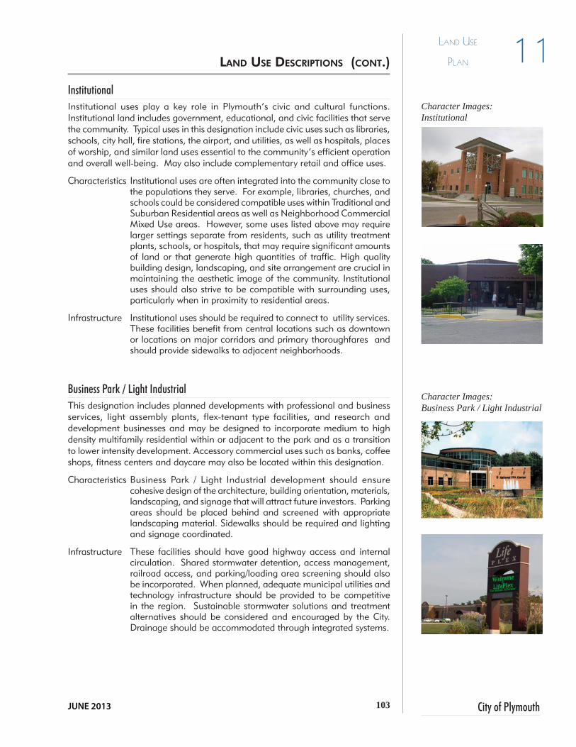
103 City of Plymouth
11Land Use
PLan
JUNE 2013
Institutional Institutional uses play a key role in Plymouth’s civic and cultural functions. Institutional land includes government, educational, and civic facilities that serve the community. Typical uses in this designation include civic uses such as libraries, schools, city hall, fire stations, the airport, and utilities, as well as hospitals, places of worship, and similar land uses essential to the community’s efficient operation and overall well-being. May also include complementary retail and office uses.
Characteristics Institutional uses are often integrated into the community close to the populations they serve. For example, libraries, churches, and schools could be considered compatible uses within Traditional and Suburban Residential areas as well as Neighborhood Commercial Mixed Use areas. However, some uses listed above may require larger settings separate from residents, such as utility treatment plants, schools, or hospitals, that may require significant amounts of land or that generate high quantities of traffic. High quality building design, landscaping, and site arrangement are crucial in maintaining the aesthetic image of the community. Institutional uses should also strive to be compatible with surrounding uses, particularly when in proximity to residential areas.
Infrastructure Institutional uses should be required to connect to utility services. These facilities benefit from central locations such as downtown or locations on major corridors and primary thoroughfares and should provide sidewalks to adjacent neighborhoods.
Business Park / Light IndustrialThis designation includes planned developments with professional and business services, light assembly plants, flex-tenant type facilities, and research and development businesses and may be designed to incorporate medium to high density multifamily residential within or adjacent to the park and as a transition to lower intensity development. Accessory commercial uses such as banks, coffee shops, fitness centers and daycare may also be located within this designation.
Characteristics Business Park / Light Industrial development should ensure cohesive design of the architecture, building orientation, materials, landscaping, and signage that will attract future investors. Parking areas should be placed behind and screened with appropriate landscaping material. Sidewalks should be required and lighting and signage coordinated.
Infrastructure These facilities should have good highway access and internal circulation. Shared stormwater detention, access management, railroad access, and parking/loading area screening should also be incorporated. When planned, adequate municipal utilities and technology infrastructure should be provided to be competitive in the region. Sustainable stormwater solutions and treatment alternatives should be considered and encouraged by the City. Drainage should be accommodated through integrated systems.
lAND UsE DEsCriPTiONs (CONT.)
Character Images:Institutional
Character Images:Business Park / Light Industrial

104Comprehensive Plan
11 Land Use
PLan
IndustrialThe Industrial land use category references heavy industry but may also include light industrial development. It is concentrated in the center and on the north side of Plymouth. The Industrial designation encompasses such uses as large manufacturing facilities, distribution, warehousing centers (not self-storage), processing plants, and other similar businesses. Industrial uses require significant utility services for production as well as protection (fire suppression, etc.). To be competitive with other cities within the region, land with this designation must contain parcels of a certain size, have excellent highway and rail access and have structures outfitted for 21st century industrial uses.
Characteristics Highway Commercial Mixed-Use and Business Park/Light Industrial may be appropriate nearby. Generally, industrial land is not compatible with residential development but the effects could be mitigated with generous buffers, perimeter fencing and vegetative screening. Industrial facilities should be located on large lots that can accommodate business and future expansion needs. Management of access to the street network will be crucial for the smooth flow of industrial traffic to such facilities. Facilities should be designed to minimize their environmental impact as well as their impact on surrounding non-industrial uses.
Infrastructure Industrial uses require significant utility services for production as well as protection (fire suppression, etc.). The need for technology infrastructure should be considered. Sustainable treatment alternatives may be approved by the City. Drainage should be accommodated through integrated systems. Locations with convenient access to major transportation infrastructure, including rail, are crucial to the viability of industrial sites.
lAND UsE DEsCriPTiONs (CONT.)
Character Images:Industrial
High quality monument signage enhances the look of industrial development

105 City of Plymouth
11Land Use
PLan
JUNE 2013
Recreation / Conservation / Open Space The Recreation/ Conservation and Open Space category encompasses public and private parks, and recreation facilities. Conservation areas containing sensitive environmental features such as wetlands, river/stream side forests, floodplains, woodlands, and other natural amenities are also included in this category. Open space and parks should be developed to meet both passive (hiking, bird watching) and active (playground, sports field) recreational needs of the community. Private or semi-public lands, such as golf courses or school playgrounds, also contribute to the overall greenspace available for community use.
Characteristics Parks & Open Space areas should occur on a variety of scales. This includes smaller, neighborhood serving parks, as well as much larger regional parks (such as Centennial Park). Parks should be integrated with residential areas where possible.
Protect land within these areas from intense development. The intent is to preserve both the sensitive natural resources that may be contained within, and to reserve land for active lifestyles, social interaction, and access/exposure to, the natural environment. Certain natural corridors, especially through heavily wooded areas or along natural waterways like the Yellow River, should be preserved as public parks or open spaces and may be highly suitable for publicly accessible, low-impact trail systems.
Infrastructure Recreation areas should be accessible from the road network, and to neighborhoods, schools, and commercial areas. Should be served with utility infrastructure appropriate to the specific activities intended for the site like refreshment stands or restroom facilities. Screen areas of potential light and noise, such as parking lots and athletic facilities, from neighboring residential uses.
Conservation areas will require no infrastructure or utility services, as they are intended to remain in their natural state.
lAND UsE DEsCriPTiONs (CONT.)
Character Images:Recreation / Conservation / Open Space
Historic and iconic elements identify a community and create a sense of place.

106Comprehensive Plan
11 Land Use
PLan
Page left intentionally blank.

City of PlymouthJUNE 2013
Focus Area Concepts 12
Section II - Implementation

108Comprehensive Plan
Focus AreA concepts12
Focus Areas One of the goals expressed by residents that emerged from this planning effort is to effectively utilize the City’s existing resources and infrastructure. Encouraging infill and redevelopment within Plymouth’s existing urban fabric, rather than expanding into greenfield (“undeveloped”) areas on the City’s edge became one of the primary recommendations generated from the public input process. Redevelopment utilizes existing public infrastructure and streets, captures or retains the embodied energy of existing buildings, strengthens the urban fabric, and preserves the surrounding natural landscape. In short, it is the ultimate way to be sustainable.
Redevelopment can occur in downtown, commercial centers, City owned property, or on brownfield sites that are abandoned, underutilized, or blighted. Redevelopment returns sites to productive uses that contribute to Plymouth’s tax base. Such a strategy can also offer opportunities to increase population density, encourage more “walkable” neighborhoods, and create a more vibrant community. The Focus Area concepts presented in this chapter represent areas of Plymouth that are experiencing or have the potential to experience significant change in the near future. Recommendations for these four Focus Areas are illustrated in the concept sketches and reflective of the character of the land use designations.
Some of the following projects have been prioritized and are labeled as part of the vision for Plymouth’s “Crossroads Corridors”. Plymouth has been referred to as “America’s Historic Crossroads”. The historically significant crossing of the Lincoln Highway (present day Jefferson Street/ U.S. 30 outside of the City) and the Dixie Highway/Michigan Road (present day Michigan Street/U.S. 30 outside of the City) are also know as the 4 - corners. The “Crossroads Corridors” projects were part of a concept for the Office of Community and Rural Affairs (OCRA) Stellar Communities Grant submittal. Though not selected, the City hopes to implement the projects over time.
Redevelopment For Focus Areas 1 (page 110) and 2 (page 112) and other areas of the City where there is existing development, the path to revitalization may be more complex, but sluggish market conditions have created an ideal opportunity to acquire or assemble land/property critical to the future of the City. Blocks of vacant and underutilized properties currently degrade the perception of the districts as welcoming, livable and economically viable places discouraging private investment.
The City owns 6.65 acres. As land acquisition and assembly is accomplished, the removal of existing structures and the rehabilitation of some will become a priority to prepare the way for a revitalized network/grid of walkable streets with residential and shoppers. The necessary upgrade to the infrastructure provides an opportunity to implement green (sustainable) storm water runoff solutions.
iNTrODUCTiON TO ThE fOCUs ArEAs
Brownfield: A site which has remained un- or underutilized due to real or perceived environmental contamination.
See map of TIF Districts on page 62.

109 City of Plymouth
Focus AreA concepts 12
JUNE 2013
FUTURE INTERCHANGE
30
31
31
MIC
HIG
AN
ST
MICHIGAN RD
MICHIG
AN ST
OA
K R
DLA
KE
AVE 5T
H
OA
K R
D
JEFFERSON ST
LA PORTE ST
HOHAM DR
JIM NEU RD
LAKE AVE
HARRISON ST
SKYLANE DR
FUTURE 7A RD
FUTURE 7A RD
9A RD
KIN
G R
D
PLYMOUTH-GOSHEN TR
PLYMOUTH-GOSHEN TR
12TH RD
GLENN-OVERMYER TR
BAKER STNORTH ST
RA
ND
OLP
H B
LVD
WES
TER
N A
VE
LIB
ERTY
ST
LINCOLN HWY
RIC
HTE
R S
T
PIO
NEE
R S
TPI
NE
RD
OLI
VE T
R
NU
TMEG
RD
MU
CK
SHAW
RD
CSX RR
NORFOLK SOUTHERN RR
POTENTIALROUND ABOUT
LINCOLN HWY
GLENN-OVERMYER TR
LINCOLN HWY
30
30
31
31
CSX RR
CSX RR
NORFOLK SOUTHERN RR
INDIANA
17
INDIANA
17
INDIANA
17
CO
RPO
RAT
E LI
MIT
S
EXTR
ATER
RIT
OR
IAL
JUR
ISD
ICTI
ON
BO
UN
DA
RY
LEGENDCorporate Boundary
Extraterritorial Jurisdiction Boundary
Planned Roads
Focus Area Projects
Crossroads Corridor Projects
fOCUs ArEA mAP
NTS
* Exact Focus Area locations to be determined.
Focus Area #3Mixed-Use Corridor Development (Typ)
Focus Area #2 Western Downtown
Revitalization
Focus Area #1Nickel Plate
Neighborhood
3
1

110Comprehensive Plan
Focus AreA concepts12 fOCUs ArEA 1 - NiCkEl PlATE NEighbOrhOOD CrOssrOADs
COrriDOrs wEsT
Existing
ExistingNew Infill
Definitely one of the top priorities in Plymouth is the improvement of a long neglected neighborhood immediately west of downtown. Public infrastructure improvements in this area will be a catalyst for new private development, new residents, and investment citywide. Several projects are envisioned including:
•Restoration of the red-brick, Pennsylvania Depot (a proposed stop on the Chicago-Cleveland High Speed Rail Corridor)
•Restoration of the urban street grid and preservation of functional alleys
• New housing in a mixture of types and styles• Brownfield reclamation to provide land for new
development•Streetscape improvements on east/west streets
to connect to neighborhoods west of the railroad tracks
•Demolition, rehabilitation / renovation for older housing. The compilation of recommended improvements are discussed in several chapters (Housing and Neighborhoods, Downtown, Economic Development) of this document.
The Pennsylvania Depot is an example of a site that could be a catalyst to spur redevelopment and investment in the first focus area.
An example of new residential infill compatible with existing homes.

111 City of Plymouth
Focus AreA concepts 12
JUNE 2013
Townhome development reflects urban development patterns and fulfills a need for enhanced housing options within the City.

112Comprehensive Plan
Focus AreA concepts12
Focus Area #2 is north of the Crossroads Corridor West project. This area is strewn with vacant and underutilized storage buildings, warehouses and manufacturing concerns that located here because of the access to rail decades ago. At that time, it was on the outskirts of the community, but now is in the heart of the community and near the Marshall County Courthouse and vibrant Michigan Street. Jefferson Street is the most important east/west corridor in the community which further illustrates the importance of revitalizing this area.
None of the development in this area, including the new suburban style residential development for seniors, low - to -moderate income and persons with disabilities, with the exception of the new Community Resource Center, reflect current planning trends. Lively, mixed-use development will spark reinvestment in this area. Recommendations to create a lively area that links the community and brings people to downtown include:
• Enhancing the streetscape of Jefferson Street to include sidewalks, curb and gutter, combined curb cuts/driveways, street lights and street trees.
• Private property owners should be encouraged to renovate facades, provide appropriately scaled signage, and to screen storage and parking lots.
• Seek out developers within the community or from others that share the City’s vision and will develop properties that respect the historic development patterns, provide structures that increase density in this district, use authentic and durable construction materials and include amenities such as sidewalks, streetlights, street trees and small urban open space (plaza, community gardens, etc).
fOCUs ArEA 2 - wEsTErN DOwNTOwN rEviTAlizATiON
Revitalized commercial strip and storage developments could provide attractive spaces for commercial and office uses.

113 City of Plymouth
Focus AreA concepts 12
JUNE 2013
FIRST ST
NICKEL PLATE RAILROAD
PLUM ST
WALNUT ST
MADISON ST
MONROE ST
JEFFERSON ST
JEFFERSON STREET CORRIDOR REVITALIZATION
Townhome and apartments development should
incorporate street trees, sidewalks, common areas and
be interconnected.

114Comprehensive Plan
Focus AreA concepts12
Examples of planned business and commercial developments employing quality design standards and building materials.
OFFICE
fOCUs ArEA 3 - mixED-UsE COrriDOr DEvElOPmENT
The potential for commercial new or revitalized mixed-use development exists in several locations throughout Plymouth including along the U.S. 30 corridor within the corporate limits and at significant intersection nodes along U.S. 31, Pioneer Road, north S.R. 17 and the proposed 7A Road. The graphic to right illustrates community development practices that should be employed for large scale development proposals. Whether for employment, entertainment , office, business or residential, the design should be cohesive and interconnected. Adhering to these basic development and design standards will ensure maximum flexibility of potential uses and allow areas to better respond to economic and employment trends.
• Cluster compatible uses. If dissimilar, use fencing, berm and vegetated buffers or screens between uses.
• Use quality authentic and durable building materials.
• Provide sidewalks, lighting, street trees and other amenities as these environments will have people in them throughout the day.
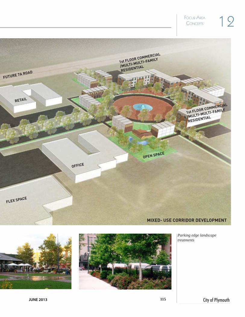
115 City of Plymouth
Focus AreA concepts 12
JUNE 2013
Parking edge landscape treatments
FLEX SPACE
RETAIL
OPEN SPACE
FUTURE 7A ROAD
MIXED- USE CORRIDOR DEVELOPMENT
OFFICE
1st FLOOR COMMERCIAL
/MULTI-MULTI-FAMILY
RESIDENTIAL
1st FLOOR COMMERCIAL
/MULTI-MULTI-FAMILY
RESIDENTIAL

116Comprehensive Plan
Focus AreA concepts12
These projects represent the three of the four “Crossroads Corridors” projects identified by the City as being essential to the enhancement and long-term vitality of the City of Plymouth. These projects were included in the 2013 OCRA Stellar
Communities application.
Crossroads Corridors South | Corner 1: South Gateway and River Park SquareThis project includes the completion of the planned River Park Square development in a downtown floodplain of the Yellow River. Envisioned are new farmer’s market facilities, a multi-use trail connecting to the Plymouth Greenways Trail, an ice rink, a performance space, an interactive fountain, gardens, and street improvements connecting the area to the historic downtown. Mixed use housing / downtown commercial is also planned adjacent to the site.
Plan to complete the RiverPark Square development.
Planned gateway signage and landscaping improvements will vastly improve the look of the South Gateway and welcome people into the City.
fOCUs ArEAs: “CrOssrOADs COrriDOr PrOJECTs 1,3 AND 4
The
Troy
er G
roup

117 City of Plymouth
Focus AreA concepts 12
JUNE 2013
The historic Rees Theater and adjoining storefront facades.
Example of potential activities in the Crossroads Community Center
Crossroads Corridors North | Corner 3: Crossroads Community CenterThe third project involves enhancements to the downtown streetscape to provide better connectivity and accessibility, and improvements to key historic buildings like historic storefronts and the Rees Theater. Built in the late 1930’s and closed in 2010, restoration of the Rees Theater would provide an ideal location for a local performing arts center to serve many of the local groups such as Encore Performing Arts, the Plymouth Youth Orchestra, the Heartland Artists, and many others.
Crossroads Corridors East|Corner 4: Crossroads Community CenterThe fourth project involves addressing specific wellness and community needs. Despite the fact that the City has a great parks system, there is no community activity center. There are multiple factors at play that further exacerbate the need for such facility. This facility already has planned users which include all residents, the Plymouth Community School Corporation, Boys and Girls Club and the St. Joseph Regional Medical Center.
The establishment of an activity center would provide year-round opportunities complementary to existing facilities and programs. The Crossroads Community Center would allow for programming goals including intramural sports, fitness/wellness activities, aquatics, sport clubs, and the hosting of special events.
Through participation at this health-oriented center, residents will learn and engage in behaviors that promote healthy lifestyles that improve the quality of life for the whole community and beyond.
The location of the Crossroads Community Center is not depicted on the map on page 111 because the location has yet to be determined.

118Comprehensive Plan
Focus AreA concepts12
Page left intentionally blank.
City of PlymouthJUNE 2013
Thoroughfare Plan
Section II - Implementation13

120Comprehensive Plan
Thoroughfare
Plan13The Transportation Plan or “Thoroughfare Plan” is the comprehensive overview and planning tool for the improvement, enhancement and maintenance of the transportation system. The plan reflects the goals, policies and action steps discussed in Chapter 10. Planning for improvement, extensions and maintenance of the city’s transportation system is essential to the livelihood of the community.
Roadways are organized as a hierarchy to facilitate safe and efficient travel via car, truck, rail, bicycle or on foot throughout Plymouth. Road classifications are intended to be compatible with land uses and community character.
The table on the following page provides a brief summary of the typical characteristics of the road classifications identified in Plymouth. Graphic illustrations of some roadway cross-sections are provided later in this chapter.
Roadway Network – Functional ClassificationsThe roadway network is made up of several different categories of streets and roadways, typically called “functional classifications”, since they describe and differentiate between the use and functions of these various types of roadways. This classification is also the basis for most roadway design, construction and safety considerations. Per INDOT planning data maps, the existing roadway network within the City of Plymouth is made up of six different functional classifications including:
•Local•Minor Collector•Major Collector•Minor Arterial•Principal Arterial•Freeway or Expressway
Right-of-way Reservation Corridors must be appropriately protected to allow for future expansion of the roadways in addition to inclusion of desired components. These components may include wider, safer shoulders with other roadside safety elements and clear zones, turn-lanes and boulevards, greenspace, landscaping and tree planting areas, allowance for utility upgrades and expansion, as well as multi-use pathways and sidewalks.
Proposed StandardsStandard road and street right-of-way widths and cross-sectional elements are defined graphically on the following pages by typical cross-sections for each category. It is generally recommended that, as new development occurs, urban cross-sections are installed to ensure effective drainage. Exceptions may include single lot residential development (not part of a platted multi-lot subdivision).
iNTrODUCTiON TO ThE ThOrOUghfArE PlAN

121 City of Plymouth
Thoroughfare
Plan 13
JUNE 2013
Street Classification Guidelines
Criteria Thoroughfare ClassificationArterial Urban Major
CollectorUrban Minor
CollectorUrban Local Rural Local
Function Inter-city and cross-town traffic, including through-trips and truck traffic. Limited access, connects communities and provides routes across man-made and natural barriers.
Neighborhood traffic, including partial cross-town traffic. Provides access to arterials and local destinations, including neighborhoods.
Neighborhood traffic, including delivery vehicles and school busses. Provides a connection between local streets and arterials.
Local traffic. Provides internal circulation within neighborhoods and connects specific areas to collectors.
Local traffic on roads serving agricultural or rural residential development
Access Control Limited access - controlled by frontage roads, medians, and spacing for intersections. No access is provided to adjacent properties
Partial access limitations - single family residential driveway access prohibited. Driveway and intersection locations are controlled
Partial access limitation - single family residential driveway access is permitted. Non-residential driveway and intersection locations are controlled.
Few access limitations, driveway access from all adjacent land uses is permitted.
Few access limitations, driveway access from all adjacent land uses is permitted.
Traffic Control Signals and Signs
Coordinated to ensure efficient movement of traffic
Used only at intersections with other collectors and arterials
Used only at intersections with other collectors and arterials
Used to yield local traffic to collector and arterial traffic
On-Street Parking
Prohibited Optional Optional Encouraged, to provide visitor and event parking and as a traffic calming measure
Curb and Gutter
Optional 2’ 2’ 2’ 4’ shoulder
Sidewalks (Min.)
6 feet 6’ 6’ required, both sides
5’ required, both sides
Multi-use Path 8’ 8’
Number of Lanes
4 lanes plus center turn or median
2 lanes plus center turn or median
2 2 2
Bike Lane 5’ minimum 5’ minimum 5’ minimum Shared Shared
Tree Lawn 15’ minimum 5’ minimum 5’ minimum 5’ minimum
Right-of-Way Width (Min.)
120 - 130 feet 100 feet 70 feet 60 feet 70 feet
sTrEET ClAssifiCATiON gUiDEliNEs

122Comprehensive Plan
Thoroughfare
Plan13
30
30
31
31
CO
RPO
RAT
E LI
MIT
S
EXTR
ATER
RIT
OR
IAL
JUR
ISD
ICTI
ON
BO
UN
DA
RY
MIC
HIG
AN
ST
MICHIGAN RD
MICHIG
AN ST
NORFOLK SOUTHERN RR
OA
K R
DLA
KE
AVE 5T
H
OA
K R
D
JEFFERSON ST
LA PORTE ST
HOHAM DR
LAKE AVE
HARRISON ST
SKYLANE DR
FUTURE 7A RD
FUTURE 7A RDPOTENTIALROUND ABOUT
9A RD
KIN
G R
D
LINCOLN HWY
PLYMOUTH-GOSHEN TR
PLYMOUTH-GOSHEN TR
12TH RD
GLENN-OVERMYER TR
BAKER STNORTH ST
RA
ND
OLP
H B
LVD
WES
TER
N A
VE
LIB
ERTY
ST
LINCOLN HWYR
ICH
TER
ST
PIO
NEE
R S
TPI
NE
RD
FUTURE INTERCHANGE
OLI
VE T
R
NU
TMEG
RD
MU
CK
SHAW
RD
30
30
31
31
CSX RR
CSX RR
NORFOLK SOUTHERN RR
INDIANA
17
INDIANA
17
INDIANA
17
ThOrOUghfArE PlAN mAP
LEGENDCorporate Boundary
Extraterritorial Jurisdiction Boundary
Principal Arterial
Minor Arterial
Major Collector
Minor Collector
Urban Collector
NTS

123 City of Plymouth
Thoroughfare
Plan 13
JUNE 2013
Arterial streets are intended to maximize vehicular mobility by providing free flowing travel lanes with minimal traffic control devices, limited driveway access, and relatively high average speeds. They are expected to carry large volumes of traffic, at relatively high speeds fed by the network of collector streets. Principal arterials in Plymouth are U.S. 30 and U.S. 31 which provide direct connectivity to other communities in the region. Michigan, Jefferson, Pioneer, and Oak Streets are examples of minor arterial roadways. All should be constructed based on the standards described below.
Character Arterial streets may be the only part travelers see of the community. Besides conveying traffic, they set the tone and leave a lasting image of the places they pass through. Functionally, arterials are at least two lanes in each direction, dedicated turn lanes at intersections, and medians separating traffic. Landscape buffers should be provided between arterial roadways and adjacent land uses, particularly residential. Bicycle and pedestrian amenities such as sidewalks and multi-use paths should be incorporated into the design of these streets. Any such sidewalks should be well separated from vehicular traffic. Lighting for arterial streets should be provided primarily at interchanges and overpasses.
Infrastructure Arterial roadways should be provided with appropriate drainage and utility infrastructure. Arterial streets should be limited access in nature, much like interstate highways, in order to maximize safety and travel efficiency. New driveways should be directed to lower classifications streets, such as collector streets, rather than to arterial streets. At-grade street intersections should be minimized, with overpasses, underpasses, and interchanges the favored treatment at these locations. Frontage road systems should be encouraged for development along arterial roadways.
ArTEriAl sTrEETs
Typical Arterial Road Section
NTS

124Comprehensive Plan
Thoroughfare
Plan13Collector streets are intermediate in scale between arterials and local streets. They are intended to provide access between arterial streets, between local streets and arterial streets, and between major activity centers such as shopping or industrial areas. Collector streets include locally significant roadways that serve major commercial areas or connect with nearby communities. They are also present in residential areas as a means of connecting neighborhoods to the overall roadway network. Examples of major collectors in Plymouth include Harrison Street, Oakhill Avenue, and Baker Street.
Access Driveway access to collector streets should be carefully controlled and managed. Shared driveways and the use of local cross-streets for access should be encouraged. Commercial properties should have access drives between them as well as pedestrian connections in order to minimize the need to use the collector street to move from one business to another.
Infrastructure Collector streets should be constructed with curbs, gutters, tree lawns, street trees, and sidewalks. Street lighting should be provided, and should be carefully designed so as to minimize its impact on adjacent residential areas. Safe pedestrian crossings should be provided at all street intersections.
Design Collector streets should be designed to accommodate moderate to high levels of traffic. At intersections with local streets, the local streets should be required to yield to traffic on the collector street. At least one travel lane should be provided in each direction, with dedicated left turn lanes provided at intersections with other collector streets. Four-way stop signs or traffic signals should only be provided at intersections of two collector streets or at the intersections of collector and arterial streets.
COllECTOr sTrEETs
Typical Urban Collector Road Section
NTS

125 City of Plymouth
Thoroughfare
Plan 13
JUNE 2013
UrbAN lOCAl sTrEETs
Local streets are the lowest order of streets, intended to provide access to individual properties. They carry low volumes of traffic at low speeds, and may have multiple driveway accesses in addition to cross street intersections. Examples of local streets in Plymouth include Monroe, Charles, and Alexander Streets.
Access Local streets are intended to provide access to individual properties. No restrictions should be placed on driveway access to local streets, except near intersections and in areas of limited sight distance. In older neighborhoods, driveway access from an alley system is highly encouraged. Heavy truck traffic should be diverted away from local streets.
Infrastructure Local streets should be constructed with curbs, gutters, tree lawns, street trees, streetlights, and sidewalks. Safe and convenient pedestrian crossings should be provided at street intersections through the provision of clear markings as well as traffic calming devices.
Design Local streets should be designed to accommodate low levels of vehicular traffic as well as high levels of pedestrian travel. Local streets should be narrow, typically with one lane for each direction of vehicular travel and on-street parking should be permitted on one or both sides of the street. In cases where on-street parking is provided, it should be defined through the use of curb extensions, and should be designed so as not to conflict with driveways accessing the street. Also, in cases where on-street parking is provided, a free area of at least one lane width should be available between parked cars to facilitate emergency vehicle access. Local street networks should be designed for maximum connectivity between residential areas.
Typical Urban Local Road Section
NTS

126Comprehensive Plan
Thoroughfare
Plan13The Multimodal Plan on page 127 includes a network of multi-use trails, greenway corridors, or on-and off-road bicycle routes. The City’s ongoing commitment to developing facilities for bicyclists and pedestrians is evidence of the amenities that yield a high quality of life enjoyed by Plymouth’s residents. The City’s role is to oversee the provision of these facilities in new public and private development and to assist with the completion of connections and links between areas that are not currently served. Future residential and commercial development should incorporate sidewalks and trail alignments within and connecting to other development. The Comprehensive Plan’s strategy is to link neighborhoods with neighborhood commercial areas, schools parks and the downtown. In the future, some of the trail network could become regional extending to nearby towns and recreational or cultural destinations in Marshall County.
In many communities the transportation network has been designed and built for the automobile but that mind-set is beginning to change throughout the nation. Communities are beginning to realize the many benefits of a multi-modal transportation network and “Complete Streets” policy. Such a policy addresses many options including vehicular, pedestrian, transit, and bicycle travel, and offers a number of health, social and economic benefits. It ensures that the entire public right-of-way is routinely designed and operated to enable safe access for all modes of transportation and all users including people of all ages, interests, and abilities. Components can include travel lanes, bike facilities, crosswalks, sidewalks, multi-use trails, medians, street trees, lighting, signage, street furnishings and on-street parking.
It is important Plymouth’s transportation network serves the existing vehicular, transit, bicycle and pedestrian systems to meet the diverse needs of residents and visitors in a safe, efficient and pleasant manner. Connectivity between destinations is crucial to integrating all the resources (parks, shopping and entertainment areas) the city has to offer. The basic street cross-section may vary by neighborhood, but to claim a “Complete Street” in a “Walkable” City, the street should contain a minimum of five-foot wide sidewalks so two people can pass comfortably. Where there is adequate right-of-way, planting strips landscaped with street trees should occur between the sidewalk and street.
On-street bicycle facility and sidewalk
mUlTimODAl CONsiDErATiONs

127 City of Plymouth
Thoroughfare
Plan 13
JUNE 2013
9A
FUTURE INTERCHANGE
30
30
31
31
CO
RPO
RAT
E LI
MIT
S
EXTR
ATER
RIT
OR
IAL
JUR
ISD
ICTI
ON
BO
UN
DA
RY
MIC
HIG
AN
ST
MICHIGAN ST
NORFOLK SOUTHERN RR
OA
KLA
KE
5TH
OA
K
JEFFERSON
LA PORTE
HOHAM
LAKE
HARRISON
SKYLANE
FUTURE 7A ROAD
FUTURE 7APOTENTIALROUND ABOUT
9A
KIN
G
LINCOLN HWY
PLYMOUTH-GOSHEN TR
PLYMOUTH-GOSHEN TR
12TH
GLENN-OVERMYER TR
BAKERNORTH
RA
ND
OLP
H
WES
TER
N
LIB
ERTY LINCOLN HWY
RIC
HTE
R
PIO
NEE
RPI
NE
FUTURE INTERCHANGE
OLI
VE
NU
TMEG
MU
CK
SHAW
30
30
31
31
CSX RR
CSX RR
NORFOLK SOUTHERN RR
INDIANA
17
INDIANA
17
INDIANA
17
mUlTimODAl mAP
LEGENDCorporate Boundary
Extraterritorial Jurisdiction Boundary
Signed Bike Route
Proposed Signed Bike Route
Unsigned Bike Route
Multi-use Path
Proposed Multi-use Path
Proposed State Visionary Trail
Proposed Yellow River GreenwayNTS

128Comprehensive Plan
Thoroughfare
Plan13Page left intentionally blank.

City of PlymouthJUNE 2013
Section II - Implementation
Implementation
Tools 14

130Comprehensive Plan
ImplementatIon tools14
Implementation AgenciesSeveral different agencies have been assigned to the “Action Items” previously listed in this Plan in order to provide more direct guidance for implementation. Agencies are broken into Lead Agencies and Supporting or Coordinating Agencies.
Lead Agencies:CC Plymouth City CouncilPC Plymouth Plan CommissionRDC Plymouth Redevelopment CommissionPK Plymouth Parks DepartmentSM Plymouth Department of Storm Water Management/ Drainage BoardLM Local MerchantsLC Local event & beautification committeesAC Plymouth Activity CoordinatorHS Historical SocietyAA Airport AuthorityU Utility CompaniesCP City of Plymouth StaffBZA Board of Zoning Appeals
Supporting or Coordinating Agencies:MCHD Marshall County Highway Dept.MCS Marshall County SurveyorMCDC Marshall County Development CorporationMCPZ Marshall County Planning & ZoningMCP Marshall County ParksINDOT Indiana Dept. of TransportationIDEM Indiana Dept. of Environmental ManagementIDNR Indiana Dept. of Natural ResourcesMACOG Michiana Area Council of GovernmentsMT Marshall County Tourism MCEDC Marshall County Economic Development CorporationPIDCO Plymouth Industrial Development CorporationMCHT Marshall County Health DepartmentMSWCD Marshall County Soil and Water Conservation District
Time FrameThe following action items have been assigned approximate time frames for the implementation of each action item. The time frames, which may vary based on economic development influences and numerous other factors, are:
Quick WinsProjects that could be undertaken immediately and/or implemented within twelve months of the Comprehensive Plan’s adoption.
Mid Term OpportunitiesProjects that could be initiated within 1-5 years of the Comprehensive Plan’s adoption.
Long Term OpportunitiesProjects that could be undertaken within 6-10+ years of the Comprehensive Plan’s adoption.
OrgANizATiONAl sTrUCTUrE

131 City of Plymouth
ImplementatIon tools 14
JUNE 2013
3 CHARACTER & IDENTITY
Policies Action Steps
Qui
ck W
ins
Mid
Ter
m
Long
Ter
m
Rel
evan
tA
genc
ies
Com
plet
ed
Ensure adequate municipal staff and resources are available to review plans, maintain, and enforce codes for existing and new development.
√ CC, RDC
Extend and apply Corridor Overlay standards for the U.S. 30, north Michigan, and Jefferson Streets. √ CC, RDC,
PC
Create user-friendly, bilingual flyers outlining city policies regarding property maintenance and upkeep. √ MT, AC
Include phased lighting and sidewalk improvements in the Capital Improvements Plan. √ CC, RDC,
Update the Subdivision Control Ordinance development and design standards to accomplish goals of the Comprehensive Plan.
√ PC, CP
Enforce the Zoning Ordinance in the incorporated and extra territorial jurisdiction to ensure compliance with required development and design standards.
√ PC, MCPZ, BZA
Develop a wayfinding signage program to inform and direct the public to destinations and districts. Investigate sources of funding wayfinding signage.
√ CC, PC, LC, MT
Design a gateway (similar theme colors or materials) and streetscape enhancements for all primary entrances to the City. Employ materials and iconic images for a distinct look and feel.
√ CC, PC, LC, MT
Consolidate the efforts of City and County business and beautification groups to create and distribute marketing materials, and to enhance streetscapes.
√ MT, PC, LC
Goal Three: Community Character. Preserve and celebrate Plymouth’s cultural and natural resources.
Goal One: Community Character. Expand the focus and attention to quality for Plymouth’s downtown “Main Street“ to encompass all community development.
1.Build on Downtown’s Character
2.Seek to balance commercial core development in downtown with continued commercial growth in other areas of the city
3.Ensure that infill and redevelopment in the city is compatible with existing neighborhood character
4.Create an attractive, inviting, and safe community
5.Lead by Example
6.Encourage Connectivity and “Walkability”
Goal Two: Corridor and Gateway Character. Support efforts to enhance community corridors and gateways.
1.Improve significant gateways to the community
2.Enhance Corridor Development

132Comprehensive Plan
ImplementatIon tools14
4 LAND USE & GROWTH MANAGEMENT
Policies Action Steps
Qui
ck W
ins
Mid
Ter
m
Long
Ter
m
Rel
evan
tA
genc
ies
Com
plet
ed
Utilize the Future Land Use Map and recommendations to prevent sprawl and leapfrog development within the two-mile ETJ.
√ PC, MCPZ
Work with Marshall County Planning and the Marshall County Economic Development Corporation (MCEDC) on an annexation strategy for property in the ETJ. Require municipal sewer and water connections.
√CC, PC, RDC,
MCEDC
Consider extending the Corridor Overlay District standards or creating Planned Unit Developments for mixed-use target growth areas.
√ CC, PC, MCEDC
Embark on a strategic annexation of parcels on the edge of the City for new, quality residential development.
√CC, PC, MCEDC, MCPZ
Encourage voluntary annexation to entice the highest and best uses that are consistent with the Future Land Use Map.
√ CC, PC, RDC
1.Refer to the Future Land Use Plan for all community land use decisions.
2.Coordinate future planning efforts with county
3.Review all aspects of development prior to permitting.
4.Support Responsible Development
5.Support the long-term vitality of the diverse institutions found in Plymouth
6.Coordinate Land Use, Transportation and Infrastructure Planning
7.Proactively plan for development on the 7A Road Bypass
Goal One: Balance. Provide a sustainable balance of land uses to support quality growth.

133 City of Plymouth
ImplementatIon tools 14
JUNE 2013
4 LAND USE & GROWTH MANAGEMENT (cont)
Policies Action Steps
Qui
ck W
ins
Mid
Ter
m
Long
Ter
m
Rel
evan
tA
genc
ies
Com
plet
ed
Create a phased master plan with site criteria for modern industrial parks. Encourage collective promotion to catalyze investment.
√PIDCO, MCEDC, PC, CC
Create a phased relocation plan for industrial businesses near downtown traditional residential areas (Norfolk Southern Railroad and Plum Street) to facilitate redevelopment and to bridge the community.
√PC, RDC, MCEDC, PIDCO
Re-purpose portions of undeveloped industrial land to other diverse uses that may develop sooner, provide revenue, and be an amenity for the community.
√MCEDC, PC, RDC,
CC
Update the City’s tax abatement policies to attract high-paying jobs to the community with new businesses that are committed for the long-term. Make City policies consistent with county policies to be competitive.
√MCEDC, PC, RDC,
CC
Re-establish the mission of the Plymouth Industrial Development Corporation (PIDCO) to focus on industrial development or form a new organization with the mission to promote developable land and enhance the skills of the workforce.
√ PIDCO, PC, CC
Consider the quantity and quality of light industrial zoned land at Pioneer Road south of the CSX Railroad.
√ MCEDC, PIDCO
The Redevelopment Commission should prepare a phased plan to redevelop underutilized City center industrial areas to create a bridge between eastern and western halves of the city and to create a “walkable community”.
√ PC, RDC
Create master plans for new and redeveloped commercial and mixed-use developments treating each as a district to shop, eat, and live.
√ PC, RDC
Encourage existing development and require new development on major thoroughfares to provide cross-access easements and/or shared driveways.
√ CP, PC, RDC
New buildings should have minimal front setbacks with parking to the rear or side of the structure. √ CP, PC
Development proposals should address not only site, building and parking layout, but also traffic, signage, connectivity and landscaping. Require a traffic impact analysis when needed.
√ CC, PC, CP
Update the Subdivision Control Ordinance to include best practices of development and design. √ CC, PC
Enforce the Zoning Ordinance to ensure compliance with required development and design standards. Code enforcement efforts should be multi-lateral involving Police, Public Works, Street and Building Departments.
√ CP, PC, BZA
1.Support high quality commercial development in Plymouth.
2.Enhance corridor development.
3.Consider alternative uses for underutilized land.
4.Encourage diverse types of residential opportunities within the City.
Goal Three: Commercial-Mixed Use Development. Unify existing mixed-use development and create commercial and residential opportunities to produce desirable, livable environments.
Goal Two: Industrial Development. Ensure a sustainable supply of “development ready” industrial locations.
1.Develop a unified strategy for attracting new business and industry to the community and retaining and expanding existing.
2.Increase the number of development-ready sites.
3.Focus on attracting diverse and innovative employers to Plymouth.
4.Support existing and creative incentives to bring new employers to Plymouth.
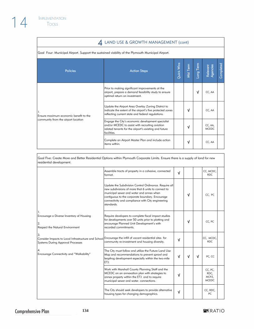
134Comprehensive Plan
ImplementatIon tools14
4 LAND USE & GROWTH MANAGEMENT (cont)
Policies Action Steps
Qui
ck W
ins
Mid
Ter
m
Long
Ter
m
Rel
evan
tA
genc
ies
Com
plet
ed
Prior to making significant improvements at the airport, prepare a demand feasibility study to ensure optimal return on investment.
√ CC, AA
Update the Airport Area Overlay Zoning District to indicate the extent of the airport’s five protected zones reflecting current state and federal regulations.
√ CC, AA
Engage the City’s economic development specialist and/or MCEDC to assist with recruiting aviation related tenants for the airport’s existing and future facilities.
√ CC, AA, MCEDC
Complete an Airport Master Plan and include action items within. √ CC, AA
Assemble tracts of property in a cohesive, connected format. √ CC, MCDC,
RDC
Update the Subdivision Control Ordinance. Require all new subdivisions of more that 6 units to connect to municipal sewer and water and annex when contiguous to the corporate boundary. Encourage connectivity and compliance with City engineering standards.
√ CC, PC
Require developers to complete fiscal impact studies for developments over 50 units prior to platting and encourage Planned Unit Development’s with recorded commitments.
√ CC, PC
Encourage the infill of vacant residential sites for community re-investment and housing diversity. √ CC, MCDC,
RDC
The City must follow and utilize the Future Land Use Map and recommendations to prevent sprawl and leapfrog development especially within the two-mile ETJ.
√ √ √ PC, CC
Work with Marshall County Planning Staff and the MCEDC on an annexation plan with strategies to annex property within the ETJ and to require municipal sewer and water. connections.
√CC, PC, RDC,
MCPZ, MCEDC
The City should seek developers to provide alternative housing types for changing demographics. √ CC, RDC,
PC
1.Ensure maximum economic benefit to the community from the airport location
Goal Four: Municipal Airport. Support the sustained viability of the Plymouth Municipal Airport.
Goal Five: Create More and Better Residential Options within Plymouth Corporate Limits. Ensure there is a supply of land for new residential development.
1.Encourage a Diverse Inventory of Housing
2.Respect the Natural Environment
3.Consider Impacts to Local Infrastructure and School Systems During Approval Processes
4.Encourage Connectivity and “Walkability”

135 City of Plymouth
ImplementatIon tools 14
JUNE 2013
5
Policies Action Steps
Qui
ck W
ins
Mid
Ter
m
Long
Ter
m
Rel
evan
tA
genc
ies
Com
plet
ed
Develop a multifamily conversion permit process to ensure that property owners dividing single-family homes comply with guidelines that help maintain the buildings’ architectural integrity and neighborhood character and ensure tenant safety.
√ CC, PC, CP
Adhere to the Downtown and Historic Neighborhood Overlay Districts in the Zoning Ordinance to maintain the existing neighborhood fabric.
√ CC, RDC, PC
Support and celebrate groups with a mission to preserve Plymouth’s urban neighborhoods and downtown. Support the Plymouth “Indiana Main Street” group.
√ CC, LM, RDC, LC
Enhance the pedestrian setting by extending decorative streetscape elements to east-west streets including Jefferson, Garro, Washington and Adams. Link the downtown and river to neighborhoods west of the railroad and east of the Yellow River.
√ CC, RDC, LC
Consider the creation of a Local Historic District or Neighborhood Conservation District for Plymouth’s core neighborhoods.
√ CC, HS, PC
The Redevelopment Commission should partner with the county, a non-profit agency or private developer to construct a signature housing project in the western downtown area that would serve as a catalyst for redevelopment.
√ √RDC,
MCEDC, MCDC
Evaluate programs that currently fund neighborhood improvement projects. Update if necessary and aggressively publicize to ensure residents are aware of available opportunities. Possible programs include matching funds, tree plantings and other beautification efforts.
√CC, RDC,
MCEDC, LC, MCDC
Continue efforts to enforce property maintenance, track and analyze enforcement actions. Research rental registry and inspection programs such as those in Bloomington and Lebanon, IN.
√ CC, BZA, CP
1.Enhance community infrastructure such as sidewalks, drainage, and street trees in core neighborhoods.
2.Support the enforcement of Plymouth’s property maintenance codes.
3.Promote Infill and Mixed-Use Redevelopment
4.Support neighborhood-based improvement initiatives.
5.Encourage Connectivity and “Walkability”
1.Ensure that new development in Plymouth’s core neighborhoods respects the historic development pattern.
2.Regulate the conversion of single-family homes to multifamily units in core neighborhoods.
3.Support the historic preservation activities of local organizations.
4.Enhance Pedestrian Comfort
Goal One: Historic Character. Preserve the historic character and development pattern of Plymouth’s core neighborhood areas.
Goal Two: Core Neighborhood Vitality. Maintain the vitality and appeal of Plymouth’s core neighborhoods.
HOUSING & NEIGHBORHOODS

136Comprehensive Plan
ImplementatIon tools14
5
Policies Action Steps
Qui
ck W
ins
Mid
Ter
m
Long
Ter
m
Rel
evan
tA
genc
ies
Com
plet
ed
The City should consider strategic annexations of land in order to provide opportunities to produce quality residential development of various types and densities within the corporate limits.
√ CC, RDC, PC
Review the Zoning and Subdivision Control Ordinances to ensure they do not prohibit traditional neighborhood development patterns on small, urban lots and do prevent suburban style development within the urban core.
√ CC, PC, CP
Seek out quality builders that are willing to construct quality, walkable single family traditional, duplex, townhome and multifamily type housing and neighborhoods that are in keeping with the character Plymouth desires.
√ CC, PC, RDC
Explore public-private partnerships for the rehabilitation of existing housing . The city can streamline process, reduce permit fees, or similar costs associated with home-building, allowing for lower final costs to the buyer.
√ CC, RDC, CP
Explore the creation of a City Housing Authority or Community Housing Development Corporation (CHDO) that can seek out funding opportunities through the Indiana Housing and Community Development Authority (IHCDA) to rehabilitate existing homes.
√ CC, MCDC
Develop a program that provides technical and/or funding assistance for qualified homeowners interested in restoring or rehabilitating older homes in traditional downtown neighborhoods. Continue Operation Bright Spot.
√ CC, CP
The City should seek developers to refresh the housing stock and provide alternative housing types for demographic groups in locations to support and meet the needs of the marketplace.
√ CC, RDC
HOUSING & NEIGHBORHOODS (CONT)
Goal Three: Housing Diversity. Provide diverse and affordable housing options for all residents of Plymouth.
1.Provide a variety of housing Options
2.Provide adequate housing options for senior citizens in the community.
3.Support the rehabilitation of homes in older neighborhoods as a method of providing affordable housing.

137 City of Plymouth
ImplementatIon tools 14
JUNE 2013
5
Policies Action Steps
Qui
ck W
ins
Mid
Ter
m
Long
Ter
m
Rel
evan
tA
genc
ies
Com
plet
ed
Update the Subdivision Control Ordinance to require appropriate infrastructure and amenities. Standards should include but not be limited to the provision sidewalks, street trees, road connectivity, municipal utilities for major subdivisions, open space.
√ √ CC, RDC, PC, CP
Evaluate the need to construct accessible pedestrian connections (sidewalks & crosswalks) to schools, shops, places of employment in subdivisions developed without them. Apply for funding from the Federal Safe Routes to Schools and the Indiana Department of Natural Resources (IDNR) Recreational Trails Programs.
√ CC, PC, CP
Create minimum design standards for new housing development that include architectural features, high quality, durable materials for homes and related neighborhood amenities.
√ CC, PC
Synchronize language in both City and County ordinances for equal treatment within the City and the ETJ.
√ CC, MCPZ, PC
Update the Zoning Ordinance to require minimum design standards for neighborhood commercial development. This can be accomplished by extending the Neighborhood Commercial Overlay District. Ensure that the requirements are properly interpreted and communicated to the development community and city decision makers.
√ PC, BZA, CC
Adopt a building materials lists to encourage certain materials and discourage others. √ PC, CC
Update the Zoning Ordinance to require landscaped and fenced buffers between incompatible uses. √ PC, CC
Encourage universal design strategies to allow for aging in place. Follow requirements as set forth by the Americans with Disabilities Act (ADA) and reccomendations by American Association of Retired People (AARP).
√ PC, CC
HOUSING & NEIGHBORHOODS (CONT)
Goal Five: Neighborhood Commercial. Provide opportunities for the development of neighborhood serving businesses.
Goal Four: Quality Housing and Neighborhood Design. Enhance the quality of residential and commercial design elements in new development.
1.Prioritize the reinvestment and redevelopment of existing Neighborhoods
2.Seek developers for new quality subdivision development on city edges but within the city limits as an alternative to County residential
3.Require municipal utilities
4.Ensure connectivity between neighborhoods and the overall street network.
5.Integrate common open space into new neighborhoods
6.Promote Pedestrian-Scaled Infrastructure
7.Promote Quality, Market-Rate or Affordable Housing
8.Universal Design for New Homes
1.Recognize and support appropriate locations for neighborhood serving commercial development.
2.Encourage the redevelopment of commercial areas along the Jefferson Street corridor.

138Comprehensive Plan
ImplementatIon tools14
6
Policies Action Steps
Qui
ck W
ins
Mid
Ter
m
Long
Ter
m
Rel
evan
tA
genc
ies
Com
plet
ed
Partner with the Marshall County Historical Society Museum to promote creative programming to celebrate the Historic Crossroads Corridor and the museum. These activities should be mutually beneficial to the museum and downtown businesses.
√ CC, HS, LM, MT
Begin a campaign to renovate the historic railroad depot on LaPorte Street as a catalyst project for redevelopment west of Walnut Street. Apply for grant funds targeted to renovate depots.
√ CC, HS, LM, MT
Partner with Marshall County Tourism, convention groups, and the Plymouth Chamber of Commerce to develop a design and theme for City, county and downtown gateway signage.
√ CC, HS, LM, MT
Review the existing downtown strategic plans to prioritize downtown revitalization projects. Begin with land acquisition and assembly of parcels for redevelopment. Potential projects include renovation of the depot and development of “urban style” downtown housing near the park, at the roller rink site and other western downtown sites.
√ CC, RDC, PC
Strengthen Downtown as a destination by continuously promoting year-round festivals, markets, cultural events, or youth activities.
√ LC, LM, AC, MT
Develop agreements to use currently under utilized parcels in the downtown, exclusive of Michigan Street for parking. Provide public parking directional signage to lots. Parking lots should be interior to city blocks or screened from streetviews behind low walls (not if a temporary use) or continuous shrub plantings.
√ CC, RDC, PC, LM
Maintain on-street parking which provides convenient access for motorists and serves as a protective buffer between pedestrians on the sidewalk and traffic.
√ CC, PC, LM
Develop a continuous off-street greenway between River Park Square and Centennial Park. √ CP, PK, PC
Work with nearby Ancilla College to encourage continued student housing within the downtown core. √ CC, RDC
1.Extend preserve effort beyond Michigan Street
2.Maintain the Variety of Architectural Styles
3.Support efforts to restore the historic railroad station(s)
4.Support Local Funding Programs
5.Promote the Historic Crossroads Corridor
Goal One: Preservation. Preserve the historic fabric of Downtown Plymouth.
DOWNTOWN
Goal Two: Activity Center. Enhance Downtown’s role as the activity center for the community.
1.Creat Distinct Downtown Gateways
2.Develop programming activities andevents for River Park. River Park Square is a community amenity and focal point
3.Provide signage to inform visitors and residents of public off street Downtown parking.
4.Encourage Downtown living
5.Support and enhance linkages between core neighborhoods,the Downtown, municipal facilities and River Park Square
6.Support and Promote Initiatives to Retain Existing Businesses
7.Update/expand Downtown promotional campaigns

139 City of Plymouth
ImplementatIon tools 14
JUNE 2013
6
Policies Action Steps
Qui
ck W
ins
Mid
Ter
m
Long
Ter
m
Rel
evan
tA
genc
ies
Com
plet
ed
PIDCO should combine efforts with other downtown organizations under the umbrella of the Plymouth Main Street group to raise funds for farmer’s market development, upgrade city parking lots (signage, bike parking, landscaping), fund downtown housing incentives, renovation or redevelopment, and to fund south gateway enhancements.
√LM, RDC,
MT, PIDCO, AC
Utilize GIS tools to inventory existing downtown infrastructure conditions creating layers that detail street widths, sidewalk gaps, street and sidewalk conditions, ADA sidewalk ramp inventory, utilities, catch basins, MS4 outfalls, street signage, street tree replacement and landscaping and lack of lighting. Such a study will allow the City to prioritize future physical improvements in the Capital Improvement Projects Plan.
√ CP
Changes within the right-of-way of Michigan Street (State Road 17) need to be coordinated with Indiana Department of Transportation (INDOT). The City should develop a conceptual plan and enter into a discussion with representatives from the local INDOT office before investing significant time and dollars.
√ CP, INDOT, and MCHD
Re-activate the Plymouth Main Street organization to serve as the primary point of contact for any initiatives in the downtown area. The City or Redevelopment Commission could assist by providing a startup fund or devoting staff time. Primary funding should come from membership / sponsorship from the private sector, merchandise, events, etc.
√LM, RDC,
MT, PIDCO, CP
Expand the Downtown TIF District to encompass targeted redevelopment areas. √ CC, RDC,
MCEDC
1.Provide quality streets, sidewalks, drainage, and utilities so that property owners are encouraged to invest in the area.
2.Provide economic incentives (such as tax abatements) to encourage investment in downtown.
3.Continue to support local stakeholders and other organizations focused on strategies and funding to enhance downtown Plymouth.
4.Address the circulation and physical improvements at the historic Crossroads Intersection of Michigan and Jefferson Street
5.Ensure Adequate and Appropriate Downtown Parking
DOWNTOWN (CONT)
Goal Three: Investment. Encourage new investment in the downtown area.

140Comprehensive Plan
ImplementatIon tools14
7
Policies Action Steps
Qui
ck W
ins
Mid
Ter
m
Long
Ter
m
Rel
evan
tA
genc
ies
Com
plet
ed
City leaders and the Redevelopment Commission should prepare a redevelopment plan that prioritizes sites in increments of 1-3 years, 3-6 years and 6-10 years. Reevaluate and update the plan every year.
√ PC, RDC, MCEDC
Inventory and assess brownfield sites and then seek funds to remediate or provide incentives to developers to clean up and develop. Begin with properties adjacent to downtown.
√ CP
Amend Zoning Ordinance to facilitate urban infill development. Ensure there is economic development expertise on the Redevelopment Commission and periodically seek outside input on project opportunities.
√ RDC, PC
The Plymouth Redevelopment Commission is charged with developing and capturing funds from TIF sites, and with the responsible reinvestment of those funds. The Redevelopment Commission should consider the goals of the plan and work with other City and local agencies to prioritize projects in a 5-year window.
√ CC, RDC, MCEDC
Encourage updates to existing industrial parks to match criteria businesses need by creating larger parcels, increasing interior building heights to 35 feet to accommodate modern industrial operations, or enhancing architectural style and amenities such as walking paths.
√MCEDC,
RDC, PIDCO
Recruit developers interested in complying with the vision established by the community. √
CC, RDC, MCEDC, PIDCO
Facilitate the application, review and permitting processes while ensuring development and design standards are complied with and not waived.
√ √ √ CP, PC, BZA
ECONOMIC DEVELOPMENT
Goal One: Redevelopment. Promote redevelopment and infill opportunities.
1.Build city-based economic development tools
2.TIF District Reinvestment Plans
3.Assess noundaries of existing downtown TIF and consider creating new or expanding existing TIF districts
4.Identify Redevelopment Zones
5.Facilitate brownfield redevelopment
6.Develop an inventory of vacant properties and/or buildings
7.Remove barriers to the development of properties in the city.
Goal Two: New Employment Opportunities. Expand initiatives to recruit diverse employers and promote additional employment opportunities.
1.Support and strengthen entrepreneurial efforts
2.Continue to coordinate with local economic development groups.
3.Identify and prioritize sites for shovel-readiness
4.Provide and maintain adequate infrastructure in existing areas of the community.
5.Incentives

141 City of Plymouth
ImplementatIon tools 14
JUNE 2013
7
Policies Action Steps
Qui
ck W
ins
Mid
Ter
m
Long
Ter
m
Rel
evan
tA
genc
ies
Com
plet
ed
Annex land west of the current corporate limits in the vicinity of Pioneer Road, north of S.R. 17 prior to development and utility extensions.
√ CC, PC, MCEDC
Activate the City’s Chamber of Commerce to promote existing and new businesses. Work also with the Plymouth Main Street organization.
√ CP, LM
PIDCO and the Redevelopment Commission could facilitate a third party market analysis to assist industrial property owners in determining current market values.
√CC,
RDC,CP, PIDCO
Consider land swaps to relocate some industrial businesses between Walnut Street and the railroad that have been a barrier to the unification of urban neighborhoods west of downtown.
√ RDC, PC
Perform an industrial properties market and absorption analysis to determine the rate of industrial development possible in a 5 to 10 year timeframe.
√ RDC, MCEDC
Consider repurposing industrial-designated land and adjusting design standards to permit a mix of uses that might be more adaptable to respond to a changing economy.
√ RDC, MCEDC, PC
Promote "green business". Support businesses that utilize environmentally sound practices. √
CP, MCEDC,
LM
1.Encourage a “personal learning network”
Promote lifetime learning through co-operative retraining programs, mentoring programs, and online classes.
√CC,
MCEDC, PIDCO, PCSC
Goal Four: Grow your talent. Support life-long learning and retraining.
ECONOMIC DEVELOPMENT (CONT)
Goal Three: Existing Businesses. Support and strengthen existing businesses and industries.
1.Expand broadband and/or fiberoptic services
2.Provide opportunities for existing business to expand
3.Create and promote a "shop local" program
4.Create business park master plans

142Comprehensive Plan
ImplementatIon tools14
8
Policies Action Steps
Qui
ck W
ins
Mid
Ter
m
Long
Ter
m
Rel
evan
tA
genc
ies
Com
plet
ed
Monitor environmentally sensitive natural features and assess the effects of potential development during the technical review of projects. This will allow the city to work more effectively with developers on site layouts sensitive to the environment.
√ √ √SM, CP,
MCS, PC, IDNR
Plat retention areas as easements including a buffer of at least 15 feet at the top of bank for emergency access and maintenance. Do not allow people to build structures or fences in easements.
√SM, CP,
MCS, PC, IDNR
Septic systems allowed in rural residential designated areas should ensure that proper soil testing is undertaken prior to construction.
√ √ √ MCHT, PC
Create incentive programs to encourage developers and residents alike to manage stormwater on site, and through natural drainage systems such as vegetated swales and rain gardens.
√ SM, CP, MCS, PC
Consider an assessment on development in MS4 areas. Develop a targeted public outreach to educate citizens on the relationship between runoff and water quality.
√ SM, MCS, MCSWCD
Update the Subdivision Control ordinance to require setbacks and other standards to conserve and protect sensitive natural features like wetlands, woodlands, heritage trees, and stream corridors.
√ CC, PC, PK
Work with the county surveyor on policies for managing river and stream corridors as environmental and recreational areas.
√ SM, PK, MCS, IDNR
Maintain a database of potentially contaminated sites and pursue grant funding for cleanup. √ CP, CC,
IDEM
Partner with developers to remediate environmentally contaminated sites with a defined incentive program. √ RDC, IDEM
1.Pursue grants and other funding mechanisms to continue the removal of existing structures from the Yellow River floodplain.
2.Remediate environmentally contaminated sites within the city.
ENVIRONMENT, PARKS, RECREATION & OPEN SPACE
1.Encourage the preservation of important natural features as a component of new development.
2.Continue to enforce the ban on the construction of homes and other permanent structures in floodway areas, particularly around the Yellow River.
3.Prevent new development on Septic Systems
4.Pursue the acquisition, dedication or set-aside of sensitive lands for permanent protection as natural open space.
5.Protect wetlands from the effects of development.
6.Environmental Education for the Community
Goal One: Redevelopment. Protect environmentally sensitive lands from the effects of development.
Goal Two: Remediation. Remediate potentially contaminated or damaged lands for environmental and economic benefits.

143 City of Plymouth
ImplementatIon tools 14
JUNE 2013
8
Policies Action Steps
Qui
ck W
ins
Mid
Ter
m
Long
Ter
m
Rel
evan
tA
genc
ies
Com
plet
ed
Work with the county surveyor on policies for managing river and stream corridors as environmental and recreational areas.
√ PK, MCS, SM, IDNR
Connect town roads, paths and trails visibly and physically to the river. Orient new development both to downtown and river as much as possible.
√ PK, CC, PC
Utilize riparian corridors as amenity areas, trail locations, and natural preserves. √ SM, PK,
MCS, IDNR
Coordinate the work of the Parks Foundation and other groups with special interests that support Kiddie Kingdom, tennis, dog park creation, amphitheater, and conservation clubhouse into one organization with a mission to raise funds for park and recreation related projects throughout the community.
√ PK, AC
Continue regular updates as necessary for the 5-year Parks Master Plan to prioritize projects and funds. This also will enable the community to be eligible for IDNR Land and Water Conservation Fund Grants.
√ PK, CC, CP
Provide links to the Yellow River Festival, sports recreation programs and other events on city website and create Plymouth Parks Facebook page.
√LM, MT,
HS, AC, LC, PK
The Urban Forestry and Flower Committee should work with the City Public Works Department to underplant existing mature tree canopies. Apply to become a Tree City USA and America in Bloom community.
√LM, MT,
AC, LC, PK, CP
Update the Subdivision Control Ordinance to require open space in areas with significant growth and subdivision development that might necessitate additional park facilities.
√ PC, PK
1.Continue to acquire land along the riverfront for the purpose of converting it to parks and open space uses.
2.Utilize the attraction of the parks and recreation system to inspire redevelopment of portions Plymouth.
Goal Four: Enhancement. Enhance and maintain existing parks, and recreation and open space system.
1.Improve existing facilities of Centennial Park.
2.Maintain the hightened public awareness of the city’s parks and recreation facilities and programs.
3.Support urban forestry throughout Plymouth.
Goal Three: Yellow River. Use the Yellow River as a tool to inspire community development.
ENVIRONMENT, PARKS, RECREATION & OPEN SPACE (CONT)
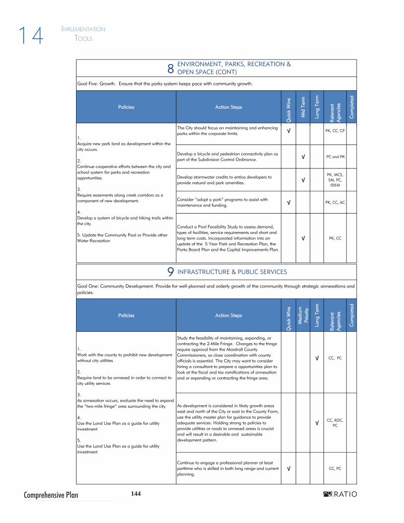
144Comprehensive Plan
ImplementatIon tools14
8
Policies Action Steps
Qui
ck W
ins
Mid
Ter
m
Long
Ter
m
Rel
evan
tA
genc
ies
Com
plet
ed
The City should focus on maintaining and enhancing parks within the corporate limits. √ PK, CC, CP
Develop a bicycle and pedestrian connectivity plan as part of the Subdivision Control Ordinance. √ PC and PK
Develop stormwater credits to entice developers to provide natural and park amenities. √
PK, MCS, SM, PC, IDEM
Consider “adopt a park” programs to assist with maintenance and funding. √ PK, CC, AC
Conduct a Pool Feasibility Study to assess demand, types of facilities, service requirements and short and long term costs. Incorporated information into an update of the 5 Year Park and Recreation Plan, the Parks Board Plan and the Capital Improvements Plan.
√ PK, CC
9
Policies Action Steps
Qui
ck W
ins
Med
ium
Pr
iorit
y
Long
Ter
m
Rel
evan
tA
genc
ies
Com
plet
ed
Study the feasibility of maintaining, expanding, or contracting the 2-Mile Fringe. Changes to the fringe require approval from the Marshall County Commissioners, so close coordination with county officials is essential. The City may want to consider hiring a consultant to prepare a opportunities plan to look at the fiscal and tax ramifications of annexation and or expanding or contracting the fringe area.
√ CC, PC
As development is considered in likely growth areas west and north of the City or east to the County Farm, use the utility master plan for guidance to provide adequate services. Holding strong to policies to provide utilities or roads to annexed areas is crucial and will result in a desirable and sustainable development pattern.
√ CC, RDC, PC
Continue to engage a professional planner at least parttime who is skilled in both long range and current planning.
√ CC, PC
INFRASTRUCTURE & PUBLIC SERVICES
Goal Five: Growth. Ensure that the parks system keeps pace with community growth.
Goal One: Community Development. Provide for well-planned and orderly growth of the community through strategic annexations and policies.
1.Work with the county to prohibit new development without city utilities
2.Require land to be annexed in order to connect to city utility services
3.As annexation occurs, evaluate the need to expand the “two-mile fringe” area surrounding the city.
4.Use the Land Use Plan as a guide for utility investment
5.Use the Land Use Plan as a guide for utility investment
1.Acquire new park land as development within the city occurs.
2.Continue cooperative efforts between the city and school system for parks and recreation opportunities.
3.Require easements along creek corridors as a component of new development.
4.Develop a system of bicycle and hiking trails within the city.
5. Update the Community Pool or Provide other Water Recreation
ENVIRONMENT, PARKS, RECREATION & OPEN SPACE (CONT)
8
Policies Action Steps
Qui
ck W
ins
Mid
Ter
m
Long
Ter
m
Rel
evan
tA
genc
ies
Com
plet
ed
The City should focus on maintaining and enhancing parks within the corporate limits. √ PK, CC, CP
Develop a bicycle and pedestrian connectivity plan as part of the Subdivision Control Ordinance. √ PC and PK
Develop stormwater credits to entice developers to provide natural and park amenities. √
PK, MCS, SM, PC, IDEM
Consider “adopt a park” programs to assist with maintenance and funding. √ PK, CC, AC
Conduct a Pool Feasibility Study to assess demand, types of facilities, service requirements and short and long term costs. Incorporated information into an update of the 5 Year Park and Recreation Plan, the Parks Board Plan and the Capital Improvements Plan.
√ PK, CC
9
Policies Action Steps
Qui
ck W
ins
Med
ium
Pr
iorit
y
Long
Ter
m
Rel
evan
tA
genc
ies
Com
plet
edStudy the feasibility of maintaining, expanding, or contracting the 2-Mile Fringe. Changes to the fringe require approval from the Marshall County Commissioners, so close coordination with county officials is essential. The City may want to consider hiring a consultant to prepare a opportunities plan to look at the fiscal and tax ramifications of annexation and or expanding or contracting the fringe area.
√ CC, PC
As development is considered in likely growth areas west and north of the City or east to the County Farm, use the utility master plan for guidance to provide adequate services. Holding strong to policies to provide utilities or roads to annexed areas is crucial and will result in a desirable and sustainable development pattern.
√ CC, RDC, PC
Continue to engage a professional planner at least parttime who is skilled in both long range and current planning.
√ CC, PC
INFRASTRUCTURE & PUBLIC SERVICES
Goal Five: Growth. Ensure that the parks system keeps pace with community growth.
Goal One: Community Development. Provide for well-planned and orderly growth of the community through strategic annexations and policies.
1.Work with the county to prohibit new development without city utilities
2.Require land to be annexed in order to connect to city utility services
3.As annexation occurs, evaluate the need to expand the “two-mile fringe” area surrounding the city.
4.Use the Land Use Plan as a guide for utility investment
5.Use the Land Use Plan as a guide for utility investment
1.Acquire new park land as development within the city occurs.
2.Continue cooperative efforts between the city and school system for parks and recreation opportunities.
3.Require easements along creek corridors as a component of new development.
4.Develop a system of bicycle and hiking trails within the city.
5. Update the Community Pool or Provide other Water Recreation
ENVIRONMENT, PARKS, RECREATION & OPEN SPACE (CONT)
8
Policies Action Steps
Qui
ck W
ins
Mid
Ter
m
Long
Ter
m
Rel
evan
tA
genc
ies
Com
plet
ed
The City should focus on maintaining and enhancing parks within the corporate limits. √ PK, CC, CP
Develop a bicycle and pedestrian connectivity plan as part of the Subdivision Control Ordinance. √ PC and PK
Develop stormwater credits to entice developers to provide natural and park amenities. √
PK, MCS, SM, PC, IDEM
Consider “adopt a park” programs to assist with maintenance and funding. √ PK, CC, AC
Conduct a Pool Feasibility Study to assess demand, types of facilities, service requirements and short and long term costs. Incorporated information into an update of the 5 Year Park and Recreation Plan, the Parks Board Plan and the Capital Improvements Plan.
√ PK, CC
9
Policies Action Steps
Qui
ck W
ins
Med
ium
Pr
iorit
y
Long
Ter
m
Rel
evan
tA
genc
ies
Com
plet
ed
Study the feasibility of maintaining, expanding, or contracting the 2-Mile Fringe. Changes to the fringe require approval from the Marshall County Commissioners, so close coordination with county officials is essential. The City may want to consider hiring a consultant to prepare a opportunities plan to look at the fiscal and tax ramifications of annexation and or expanding or contracting the fringe area.
√ CC, PC
As development is considered in likely growth areas west and north of the City or east to the County Farm, use the utility master plan for guidance to provide adequate services. Holding strong to policies to provide utilities or roads to annexed areas is crucial and will result in a desirable and sustainable development pattern.
√ CC, RDC, PC
Continue to engage a professional planner at least parttime who is skilled in both long range and current planning.
√ CC, PC
INFRASTRUCTURE & PUBLIC SERVICES
Goal Five: Growth. Ensure that the parks system keeps pace with community growth.
Goal One: Community Development. Provide for well-planned and orderly growth of the community through strategic annexations and policies.
1.Work with the county to prohibit new development without city utilities
2.Require land to be annexed in order to connect to city utility services
3.As annexation occurs, evaluate the need to expand the “two-mile fringe” area surrounding the city.
4.Use the Land Use Plan as a guide for utility investment
5.Use the Land Use Plan as a guide for utility investment
1.Acquire new park land as development within the city occurs.
2.Continue cooperative efforts between the city and school system for parks and recreation opportunities.
3.Require easements along creek corridors as a component of new development.
4.Develop a system of bicycle and hiking trails within the city.
5. Update the Community Pool or Provide other Water Recreation
ENVIRONMENT, PARKS, RECREATION & OPEN SPACE (CONT)
8
Policies Action Steps
Qui
ck W
ins
Mid
Ter
m
Long
Ter
m
Rel
evan
tA
genc
ies
Com
plet
ed
The City should focus on maintaining and enhancing parks within the corporate limits. √ PK, CC, CP
Develop a bicycle and pedestrian connectivity plan as part of the Subdivision Control Ordinance. √ PC and PK
Develop stormwater credits to entice developers to provide natural and park amenities. √
PK, MCS, SM, PC, IDEM
Consider “adopt a park” programs to assist with maintenance and funding. √ PK, CC, AC
Conduct a Pool Feasibility Study to assess demand, types of facilities, service requirements and short and long term costs. Incorporated information into an update of the 5 Year Park and Recreation Plan, the Parks Board Plan and the Capital Improvements Plan.
√ PK, CC
9
Policies Action Steps
Qui
ck W
ins
Med
ium
Pr
iorit
y
Long
Ter
m
Rel
evan
tA
genc
ies
Com
plet
edStudy the feasibility of maintaining, expanding, or contracting the 2-Mile Fringe. Changes to the fringe require approval from the Marshall County Commissioners, so close coordination with county officials is essential. The City may want to consider hiring a consultant to prepare a opportunities plan to look at the fiscal and tax ramifications of annexation and or expanding or contracting the fringe area.
√ CC, PC
As development is considered in likely growth areas west and north of the City or east to the County Farm, use the utility master plan for guidance to provide adequate services. Holding strong to policies to provide utilities or roads to annexed areas is crucial and will result in a desirable and sustainable development pattern.
√ CC, RDC, PC
Continue to engage a professional planner at least parttime who is skilled in both long range and current planning.
√ CC, PC
INFRASTRUCTURE & PUBLIC SERVICES
Goal Five: Growth. Ensure that the parks system keeps pace with community growth.
Goal One: Community Development. Provide for well-planned and orderly growth of the community through strategic annexations and policies.
1.Work with the county to prohibit new development without city utilities
2.Require land to be annexed in order to connect to city utility services
3.As annexation occurs, evaluate the need to expand the “two-mile fringe” area surrounding the city.
4.Use the Land Use Plan as a guide for utility investment
5.Use the Land Use Plan as a guide for utility investment
1.Acquire new park land as development within the city occurs.
2.Continue cooperative efforts between the city and school system for parks and recreation opportunities.
3.Require easements along creek corridors as a component of new development.
4.Develop a system of bicycle and hiking trails within the city.
5. Update the Community Pool or Provide other Water Recreation
ENVIRONMENT, PARKS, RECREATION & OPEN SPACE (CONT)

145 City of Plymouth
ImplementatIon tools 14
JUNE 2013
9
Policies Action Steps
Qui
ck W
ins
Med
ium
Prio
rity
Low
Prio
rity
Rel
evan
tA
genc
ies
Com
plet
ed
Educate the development community, county and residents as to the importance of requiring connection to municipal utilities (water and sewer).
√ CC, PC, CP
Upgrade 4” and 6” lines to 8, 10 or 12” of sewer and force main extensions to increase capacity of proposed utilities to serve existing areas and to allow for growth and adequate delivery. Consider partnering with existing large users and developers to share the cost and speed upgrades.
√ CC, CP
Maintain the inter-local agreements to help fund fire protection. √ CC, CP
Utilize the Water & Sewer Master Plan to identify critical corridors that could be used for easements and then secure them during the development approval process.
√ CC, CP
Establish a second fire station in the western sector of the Caaity (likely growth area), in order to increase service coverage and reduce response times.
√ CC, CP
Evaluate the need for a fire safety training facility in Plymouth vs. sharing the Warsaw facility √ CC, CP
Resolve volume and pressure issues in the vicinity of Richter Road with new tower and larger service lines. √ CC, CP
Keep existing or locate new municipal facilities in the city center to catalyze develop and investment in that area
√ CC, CP
Continue to stencil signs on inlets and drains that caution against improper disposal of hazardous materials (motor oils), herbicides, fertilizer that affect the health of the Yellow River.
√ CC, CP, SM
Continue to utilize a 5-year Capital Improvements Plan (CIP) to identify, organize and prioritize projects and funding sources. The CIP should be reviewed and updated annually. A cost/benefit analysis should be undertaken as part of the CIP plan process.
√ CC, CP, RDC
Continue to update a wellhead protection overlay district as a component of the zoning ordinance. Increase awareness by publicizing the impacts that residents and businesses can have on water quality.
√ CC, SM, IDEM, CP
INFRASTRUCTURE & PUBLIC SERVICES (CONT)
Goal Two: Utility Public Services and Investment. Support the community’s land use objectives, utilities investments and policies.
1.Enhance the city’s relationship with Plymouth Community Schools.
2.Ensure the safety of the community’s drinking water.
3.Maintain adequate capacity in the City’s sewer and water systems.
4.Support the continued addition of capacity for the city’s public safety services.
5.Facilitate the coordination of planning services with Marshall County.

146Comprehensive Plan
ImplementatIon tools14
9
Policies Action Steps
Qui
ck W
ins
Med
ium
Pr
iorit
y
Low
Prio
rity
Rel
evan
tA
genc
ies
Com
plet
ed
Convey vision for the US 31/ 7A interchange and gateway and corridor improvements to INDOT. Consider including landscaping, art, signage or some other marker to increase awareness that one has arrived in Plymouth and that it is a “place” to stop.
√ INDOT, CC, MCHD, LC
Work with INDOT to communicate vision for streetscape enhancements including gateways, lighting, signage, landscaping and managed access on U.S. 30, U.S. 31 and S.R. 17 corridors.
√ INDOT, CC, CP, MCHD
The Historic Crossroads intersection at Jefferson and Michigan Streets should celebrate history and showcase the important vehicular and pedestrian connector that it is. Urban design and building siting can create the edge and enhance the prominence of this intersection at the heart of the City.
√HP, MT,
HS, INDOT, CC, MCHD
INFRASTRUCTURE & PUBLIC SERVICES (CONT)
Goal Three: Coordination. Coordinate with other local, regional and state jurisdictions to ensure that community infrastructure needs are met.
1.Coordinate with the Indiana Department of Transportation to preserve community access to U.S. 31 after planned improvements
2.Add amenities to Pioneer Road on the west side of Plymouth.
3.Work with the Indiana Department of Transportation to improve safety along U.S. 30 through Plymouth
4.Coordinate utility extension policy with Marshall County
5.Continue active participation in regional planning, specifically through involvement with MACOG

147 City of Plymouth
ImplementatIon tools 14
JUNE 2013
10
Policies Action Steps
Qui
ck W
ins
Mid
Ter
m
Long
Ter
m
Rel
evan
tA
genc
ies
Com
plet
ed
Continue to review and update the 5-year Capital Improvement Plan (CIP) for use by municipal departments, boards and commissions to identify, prioritize and fund projects related to public services and facilities.
√ CC, CP, RDC
Continue to update the City of Plymouth Standard Specifications Manual to include engineering standards for new roadway projects (pavement width, apron design, subsurface and installation details, etc.).
√ CC, CP
UPDATE the Subdivision Control Ordinance to guide the layout and development of commercial, industrial and residential subdivisions, including block layout, access standards, roadway type, the use and length of cul-de-sacs, provision of multi-use paths, sidewalks, bike facilities, streetlights, landscaped buffers and curb and gutter standards.
√ PC,CC, CP
Implement access management policies for U.S. 30, U.S. 31, Michigan and Jefferson Streets which include no additional curb cuts, shared access/driveways, and cross-access easements between parcels.
√ INDOT, CC, CP, MCHD
Strengthen east-west connections such as Jefferson Street. Conduct a traffic study to provide a roundabout at Pioneer to facilitate movement where future development is anticipated.
√ INDOT, CC, CP, MCHD
Comply with the standards and cross-sections in this plan that acknowledge the importance of complete streets and provides space for bicycles and pedestrians with the travel ways.
√ PC, CC, CP, MCHD
Celebrate the historic transportation Crossroads Corridors that bisect Plymouth: Lincoln Highway, Michigan Road, Dixie Highway, Yellowstone Trail. Use public art, markers, signage or special materials to highlight the routes.
√HP, MT,
HS,INDOT, CC, MCHD
Goal One: Strengthen Local and Regional Connectivity. Ensure that new street systems provide links between destinations within and outside the City in a safe and effective manner.
1.Reference the Thouroughfare Plan
2.Work with the Indiana Department of Transportation to improve safety along U.S. 30 through Plymouth.
3.Create a system of designated truck routes through the community to serve the industrial parks and increase traffic safety.
4.Facilitate systematic improvements to enhance the performance of existing roads.
5.Require vehicular and pedestrian connectivity between subdivisions.
6.Encourage mixed land use patterns
7.Consider all modes of transportation when evaluating the street system.
8.Support efforts to enhance air travel to Plymouth and Marshall County.
9.Support efforts to strengthen rail access.
TRANSPORTATION

148Comprehensive Plan
ImplementatIon tools14
10
Policies Action Steps
Qui
ck W
ins
Mid
Ter
m
Long
Ter
m
Rel
evan
tA
genc
ies
Com
plet
ed
UPDATE the Subdivision Control Ordinance to require sidewalks and multiuse paths in new residential, commercial and industrial developments to some extent.
√ PC,CC, CP
Ensure that new or improved roads match the recommendations in the Thoroughfare plan road facilities providing the required amount of right-of-way to accommodate vehicles, bikes and pedestrians and street trees.
√ PC,CC, CP
Continue to appropriate funds in the CIP to implement the City’s Adopted ADA transition plan. √ CC, CP
Maintain a Sidewalk Improvement Plan in additions to the ADA Transition Plan. Document the needs and accomplishment on a GIS layer. These products will influence the prioritization of improvements in the CIP and will assist in seeking grant funding such as from the Safe Routes to School program. Establish an escrow fund for sidewalks that developers can contribute to in lieu of providing required sidewalk on subject properties at the time of development in special circumstances, not as a matter of course.
√CC, PK,
MACOG, CP
Actively pursue easements along creeks, the river, adjacent and in agricultural areas in order to implement a continuous greenway corridor.
√ CC, MCS, PK, CP
Enhance Gateways for gateway community entrances at key locations along thoroughfares at the edges of the City.
√ CC, CP
Celebrate the fact that Plymouth is a Tree City USA and American Bloom community. Prepare signage, sponsor events, involve service organizations of both older and younger citizens.
√ CC, MT, CP
Goal Three: Image Enhancement. Utilize the transportation network to promote a positive community image.
1.Promote Attractive New Streetscapes
2.Encourage Public Interaction with Natural Systems
1.Require the construction of sidewalks in all new development.
2.Support the development of a greenways trail system connecting important destinations within the community and regionally
3.Require the provision of bicycle parking facilities as a component of new commercial and multifamily development
4.Continue to implement the ADA Transition Plan
5.Consider a fixed-route transit circulators to common destinations in Plymouth.
Goal Two: Alternative Transportation. Enhance multi-modal transportation infrastructure.
TRANSPORTATION (CONT)
City of PlymouthJUNE 2013
Section IV - Supporting Data
A. Meeting Summary’s
B. Demographic Data
Appendix 15

150Comprehensive Plan
AnAlysis
DAtA15 09/10/2012 kiCk Off mEETiNg sUmmAry
M E E T I N G S U M M A R Y
RATIO Architects, Inc.
RATIOarchitects.com
Architecture
Preservation
Interior Design
Landscape Architecture
Urban Planning & Design
Graphic Design
107 South Pennsylvania Street, Suite 100 Indianapolis, Indiana 46204-3684 317.633.4040 f: 317.633.4153
Indianapolis, IN Champaign, IL Raleigh, NC Chicago, IL
Project: Plymouth Comprehensive Plan Update
RATIO Project No.: 12074.000
Date/Time: September 10, 2012 4:00pm
Purpose: Kickoff project, 2003 Comprehensive Plan review, and issue identification
Held at: Video Conference (RATIO office / Plymouth High School)
Participants: Mayor Senter, Sean Surrisi, Brent Martin, Mike Hite, Rick Gaul, Derek Speier, Bill Neal, Keith
Hammonds, Jackie Turner (RATIO), Jen Higginbotham (RATIO)
After introductions, the Mayor began by stating that the existing comprehensive plan is due an update and the community is eager to get started. Jackie Turner (RATIO) briefly reviewed the schedule, stating that the community will be on track for having a draft about the time to draft a letter of intent for Stellar Communities grants. The majority of the meeting involved reviewing action steps, or “Getting Started” items from the 2003 Comprehensive Plan. The list of steps was sent to attendees in advance to allow time for review prior to the meeting. Comments follow.
• One attendee asked consultants to make sure that the plan clearly states that it addresses a 10-20 year vision for growth and development, and is not a short term plan or zoning document / map.
o Jackie will provide a handout to the steering committee and the public regarding the long term nature of comprehensive Planning
• The Plymouth Fertilizer Company is still in operation but no longer includes animal rendering. Has helped air quality. • The community updated the zoning ordinance in 2008 to include additional zoning districts to meet their needs.
o With regard to open space, the ordinance is more park-oriented and lacks policies for natural areas o The industrially zoned land off Pioneer Drive on the west side of town (not yet certified by the state) needs
further evaluation. Many industrial lots are too small for new development. That area does not match what is proposed in the Capital Improvements Plan (CIP). There are also flood plain issues.
o A downtown overlay district was created in addition to the C2 downtown zoning district. The community may want to consider defining a modified downtown boundary, possibly related to
the downtown overlay zoning district. • Sean and Jennifer Laurent (EDC) have been discussing how to appropriately revise the city’s tax abatement policies. • Utilities were discussed.
o A policy is needed to determine when/if septic and well service is acceptable for new and existing development.
o The Michiana Area Council of Government (MACOG), which provides rural planning services in Marshall County, created an analysis of the infrastructure system targeting a 20-year expansion. The Transportation Plan is expected to be published near the end of 2012.
o The City’s water expansion project is ongoing (2012), but there are concerns about wastewater and overall capacity. Currently, there are 3 major users in the City and little capacity to accommodate a new large industrial tenant, should one choose to locate in the community. One current industrial business is considering expansion, which will impact the system. These limitations do not preclude all new service expansion; clarification from the utility is necessary to determine actual conditions/limitations.
• The airport has made many improvements in the previous two years including physical improvements to buildings, a new board (2008), a new director (2010), and widened the runway.
o The 2008 Zoning Ordinances includes an Airport Overlay District. o Sean is working with the Board of Aviation Commissioners (BOAC) to evaluate the opportunities for long term
leasing of hangars for larger investors. BOAC is courting the Culver Aviation Program to locate there. o Jackie mentioned that RATIO’s recent work with the Columbus BOAC may provide helpful insights into land
uses and expansion (airport master plan). • The housing market has been somewhat stagnant during the recession.
o A local production home builder (Collins & Associates) continues to operate and currently creates a mixture of single-family (SF) and multi-family (MF).
They are currently creating senior active lifestyle villas on the near-northside.

151 City of Plymouth
AnAlysis
DAtA 15
JUNE 2013
09/10/2012 kiCk Off mEETiNg sUmmAryPlymouth Comprehensive Plan Kick-Off Meeting Page 2 September 10, 2012
o The community has Millers assisted living housing as well as six HUD senior housing projects. o Though the previous Comprehensive Plan stated a need for reduced cost of development, the community has
prioritized quality while continuing to consider cost. The community also may be interested in some standards for home design to minimize front-
facing garages and other common design elements that are undesired. o There is a lack of housing downtown for residents with higher income. Current downtown residents tend to
be moderate to low income. The older neighborhoods downtown have declined since the previous plan. o There are no Community Development Corporations to specifically encourage and facilitate reinvestment in
downtown development and housing, though the community is considering an Economic Development Target Area, potentially lead by the Redevelopment Commission, to catalyze reinvestment.
o The community believes itself to have a higher than average percentage of rental property. • When asked what type of resident Plymouth would like to have more of, attendees mentioned a skilled work force to
staff the local manufacturing companies. o An active partnership between the employers and educators has been launched to ensure a more suitable
workforce, and Purdue Technical Assistance program and Ivy Tech Community College have been engaged to implement relevant skills training.
• With regard to maintenance and code enforcement, the City has done well. Operation Bright Spot was created to eliminate some blighted properties.
• Culturally, the Blueberry Festival (September) is still strong and regionally recognizable. The Yellow River Festival (June) is smaller and more locally attended, with a different theme.
• The 5-Year Parks and Recreation Master Plan was adopted in 2011, and a new downtown park is anticipated to break ground in spring 2013. TE grants to implement Phase II of the greenway have not been successful, but the City is exploring alternatives.
• Transportation issues o A new entrance from US 31 at 7A Road on the north side of Plymouth is planned, which has the potential to
impact the local transportation system and development potential. o As required, the City’s sidewalks have been mapped for ADA compliance and a project priority list has been
created. The City is working on this project list to bring the City into compliance. There are missing areas of sidewalks within the City which are not addressed in the mapping.
o The County has a Highway Superintendent RATIO will contact during the process. • The community annexed a 40-acre field adjacent to low density estate homes in 2009/2010, now zoned R-2. The City
does not currently have plans for further annexation, except for possibly with the creation of the planned entrance from US 31 into the north side of the community.
• The City has three TIF districts, which can be seen on the Marshall County GIS website along with the new floodplains. Collection of data and dates for the Steering Committee meeting were discussed.
• Rick will send contact information for the Public Works Department to allow RATIO to gather GIS information for mapping purposes.
• Wednesday and Thursday evenings are preferred for steering committee meetings. The first steering committee meeting will be Wednesday September 26th. RATIO will send an invitation letter that the City can send to the SC members.
Any additions or corrections to this summary should be submitted in writing to RATIO Architects, Inc., within ten (10) days of receipt. Otherwise, this summary stands as correct. Respectfully submitted, Jen Higginbotham, AICP Planner cc: Meeting Attendees (see summary header)
RATIO Architects, Inc. project file

152Comprehensive Plan
AnAlysis
DAtA15 09/26/2013 sC mEETiNg sUmmAry
P R O G R E S S M E E T I N G S U M M A R Y
RATIO Architects, Inc.
RATIOarchitects.com
Architecture
Preservation
Interior Design
Landscape Architecture
Urban Planning & Design
Graphic Design
107 South Pennsylvania Street, Suite 100 Indianapolis, Indiana 46204-3684 317.633.4040 f: 317.633.4153
Indianapolis, IN Champaign, IL Raleigh, NC Chicago, IL
Project: Plymouth Comp Plan
RATIO Project No.: 12074.000
Date/Time: September 26, 2012 5pm
Held at: Plymouth Conservation Clubhouse
Participants: Mayor Mark Senter, Ralph Booker, Donnie Davidson, Rick Gaul, Mark Gidley, Keith Hammonds, Jeff Houin, Jim Marquardt, Brent Martin, Mike Miley, Dave Morrow, Diana Neilsen, Linda Rippy, Sean Surrisi, Jackie Turner, Jen Higginbotham
Mayor Senter introduced the project and the reason why the City is updating its Comprehensive Plan. He noted the upcoming stellar communities grant opportunity and highlighted areas of town that are in need of enhancement. All attendees introduced themselves and the group they represent. Jackie addressed the contents of project folders.
• Project schedule • A handout on Comprehensive Plans, their benefits, and the enabling state legislation • A handout for the project website www.CommunityCollaborate.com, with steering committee password for
potential draft material review • A contact sheet for consultants and committee members
Jackie Turner presented the many planning initiatives that the community has engaged in during the last decade including the 2003 Comprehensive Plan, a greenways plan, two downtown plans, the recently updated Parks and Recreation Master Plan, and a master plan for the new downtown park. Committee members should review. All of these plans are posted to the project website. Exercise #1 Attendees used post-it notes to identify one thing they like about Plymouth and one thing they would change. Results were grouped in categories of similar answers.
• Likes: o Charm, Small Town feeing, Friendly o Centennial Park, the Library, the Amphitheater o The City has good regional access
• Want to change: o Streets need repairs, too much rental housing o Need aggressive improvements to the job market o Want better accessibility and cycling facilities, more things to do, higher education provider, and
need to address the community’s resistance to change Exercise #2 The committee broke into two groups, each at a table with two maps of Plymouth at different scales. The groups were asked to identify locations on the map that were significant (examples of good development, uses they want more of, uses they want less of, annexation and redevelopment opportunities, major corridors, recent improvements, etc.). The following discussions took place.
• Group A o The City has an urban forestry (tree) program; Michigan Street in particular is very impressive. The
City needs to begin underplanting mature trees in anticipation of declining health.
Kick Off Meeting Purpose:

153 City of Plymouth
AnAlysis
DAtA 15
JUNE 2013
09/26/2013 sC mEETiNg sUmmAryPlymouth Steering Committee Meeting Page 2 September 26, 2012
A week before the meeting the Emerald Ash Borer was found in Plymouth. It is likely that a large number of mature Ash trees will need to be removed.
o The City should consider more aggressive annexation strategies. A committee member who lives in the extraterritorial jurisdiction (planning fringe) outside of the corporate limits would like to see all people who live in that fringe pay into the services (parks, police, fire, utilities) that they use.
o There was much discussion about the condition of downtown housing. The size and density of downtown housing stock is adequate, but the lack of maintenance and condition turn away potential homebuyers who instead purchase housing in newer subdivisions. Not enough willing “fixer-uppers”. It may be necessary for the City to encourage the formation of a community development
commission (CDC) or redevelopment commission to rehabilitate housing and catalyze reinvestment in urban neighborhoods.
Residential areas are nicer on the east side off Michigan Street. This may indicate a physical or mental barrier to reinvestment. Several cross streets on Michigan do not align at the intersections, which may cause a break in the linkages between the two sides.
o Occupied senior housing near downtown is evidence of demand for this housing type. o Some of the nicer subdivisions are those developed south of the city. The builders wanted to
develop closer to the center of the city but the city utilities were unable to accommodate the necessary additional capacity at that time.
o The areas most in need of redevelopment and investment are residential and industrial areas near downtown.
o Plymouth needs a fine dining establishment for lunch and dinner. The Vine filled that need, but has closed. The community may want to target an established locally owned restaurant from a
regional community and convince them to start a second business in Plymouth. • Group B
o Industrial and business parks in the north of the city are on the edge of being shovel ready. One issue is that the parcels are relatively small (<15 acres) to attract many businesses.
o Much of the northern gateway is tired commercial strip development. Additional streetscape improvements needed
o Need better connections to between town and neighborhoods to the Yellow River o There is a priority to redevelop area in the vicinity of the Elkhart-Western railroad between CSX-
Chicago Ft. Wayne and North Street. o Revitalization of the RR depot is desired o Bike path along CSX railroad east of town is desired
Also Heard
• The community needs: o to be open to change o to figure out its vision with regard to aging and opportunities. The City should address the aging
population; there are not many young people on the steering committee. The community demographics will be updated to ensure that is still the case, and if so we
will need to ask the community how it envisions itself. o Jobs for people with higher degrees
• Some communities choose to cater to only certain age groups, such as retirees with active lifestyles, or may choose to be a certain type of community, like “bedroom community” which may have good lifestyle options (housing, entertainment, family activities), but few jobs and therefore many commuters.
• The plan should:

154Comprehensive Plan
AnAlysis
DAtA15 09/26/2013 sC mEETiNg sUmmAryPlymouth Steering Committee Meeting Page 3 September 26, 2012
o identify the current and appropriate future balance of land uses with regard to job types o the capacities and service areas for municipal utilities
• A committee member asked how often the plan should be updated. o The Plan should be reviewed annually and updated every five to ten years in response to land use
trends, changes in population, or major events that may affect the community’s future. This will ensure the Plan and its individual elements remain relevant. Diligent monitoring and maintenance of the plan’s goals and objectives will ensure proper guidance regarding future growth and development. Elements may be updated individually, like housing or economic development, as opposed to an entire document update.
• The Plan Commission is the body appointed by the Council and charged with the responsibility for making land use decisions (Indiana state statute). The Comprehensive plan is one of the primary tools. It may be necessary for Plymouth’s Plan Commission to receive additional training on using the plan.
Advertising the Workshop A public workshop is planned for mid-October; several strategies should be utilized including:
• the popular local radio show • Bilingual notices to ensure outreach to the Hispanic population; a translator for the workshop? • Community Facebook page? • Local organizations (Chamber, EDC, churches, well-known businesses, schools, etc.) email lists that are
willing to send out an announcement to their subscribers Potential stakeholder groups (Max of 4 – can be combined)
• Business park / industrial park owners / commercial brokers • Downtown business owners and residents • Utilities / streets / parks staff • Historic and cultural resources / Social service agency representatives • High school students – Government class • County personnel - Jennifer and Derek, Ralph Booker
Tasks for the committee:
• Review the “Getting Started” items from the 2003 plan and confirm completion where it has occurred. • Provide input to the consultant on the most important community groups to interview as stakeholders
Tasks for the consultant:
• Commuter data • Demographic data • Trade area data • Utility service areas • Public Outreach materials
Any additions or corrections to this summary should be submitted in writing to RATIO Architects, Inc., within ten (10) days of receipt. Otherwise, this summary stands as correct. Respectfully submitted, Jen Higginbotham / Jackie Turner Planners cc: steering committee, file

155 City of Plymouth
AnAlysis
DAtA 15
JUNE 2013
09/26/2013 grAPhiC mEETiNg sUmmAry
LINCOLN HWY
JEFFERSON ST
LIBER
TY STB
AYLESS ST
11TH RD11TH RD
9TH RD
7TH RD
7TH RD
7B RD
JIM NEU DR
HARRISON ST
MADISON ST
9TH RD
BAKER ST
GARRO ST
LAKE AVE
PLU
M ST
RA
ND
OLP
H B
LVD
CO
LUM
BU
S DR
7B RD
6TH RD
6A RD
5A RD
5B RD
5C RD
6TH RD
12TH RD
11B RD
MA
PLE R
D
MU
CK
SHAW
RD
NU
TMEG
RD
PIO
NEER
DR
PIO
NEER
DR
PIN
E RD
OLIVE R
D
LILAC
RD
LIND
EN TR
AIL
KIN
G R
D
QU
INC
E DR
KIN
G R
D
PENNSYLVANIA AVE
PLYMOUTH GOSHEN TRAIL
FUTURE US 31 CONNECTOR
MICH
IGAN RDOAKHILL AVE
13TH RD
LINCOLNWAY
MIC
HIG
AN
RD
OA
K R
D
OLIVE TR
AIL
LINCOLN HWYJEFFERSON ST
PLYMOUTH GOSHEN TRAIL
HWY 30
HW
Y 31
MICH
IGAN R
D
OAKHILL AVE
13TH RD
17
LINCOLNWAY
MIC
HIG
AN
RD
OA
K R
D
LIA
RT E
VIL
O
N0 1200 2400 4800 FEET
PLYMOUTH, INDIANA
EXTRA TERRITORIAL JURISDICTION LIMITS
CORPORATE LIMITS
LIBER
TY STB
AYLESS ST
11TH RD11TH RD
9TH RD
7TH RD
7TH RD
7B RD
JIM NEU DR
HARRISON ST
MADISON ST
9TH RD
BAKER ST
GARRO ST
LAKE AVE
PLU
M ST
RA
ND
OLP
H B
LVD
CO
LUM
BU
S DR
7B RD
6TH RD
6A RD
5A RD
5B RD
5C RD
6TH RD
12TH RD
11B RD
MA
PLE R
D
MU
CK
SHAW
RD
NU
TMEG
RD
PIO
NEER
DR
PIO
NEER
DR
PIN
E RD
OLIVE R
D
LILAC
RD
LIND
EN TR
AIL
KIN
G R
D
QU
INC
E DR
KIN
G R
D
PENNSYLVANIA AVE
Good Housing
Good Housing
Proposed Transportation
Potential Annexation?
Shovel Ready? Lots are < 15 acres
Lighting Stops
Connect Green Space
Redevelopment
Norfolk Southern /
Elkhart Western
Airfield
CSX - Chicago/Fort Wayne
Bike Path
Good Housing
TIF 3Tech & Retail
TIF 3Retail
Residential Areas outside of Sanitary Sewer Service Area
Downtown Needs
Grocery
Senior Housing
Lined with Trees
Blight
Potential Annexation?
Potential Annexation?
Redevelopment
Potential Annexation?
Good Housing

156Comprehensive Plan
AnAlysis
DAtA15 P R O G R E S S M E E T I N G S U M M A R Y
RATIO Architects, Inc.
RATIOarchitects.com
Architecture
Preservation
Interior Design
Landscape Architecture
Urban Planning & Design
Graphic Design
107 South Pennsylvania Street, Suite 100 Indianapolis, Indiana 46204-3684 317.633.4040 f: 317.633.4153
Indianapolis, IN Champaign, IL Raleigh, NC Chicago, IL
Project: Plymouth Comp Plan
RATIO Project No.: 12074.000
Date/Time: December 6, 2012 6pm
Purpose: Steering Committee Meeting
Held at: Plymouth Wastewater Treatment Facility
Participants: Ralph Booker, Donnie Davidson, Rick Gaul, Mark Gidley, Jeff Houin, Brent Martin, Mike Miley, Mike Kershner, Derek Spier, Sean Surrisi, Jackie Turner
Jackie Turner greeted and updated the attendees on the schedule. Using a PowerPoint to convey information, the group reviewed key points about the community’s demographics changes and highlights from the summary of stakeholder meetings and public input. The PowerPoint, public input summary are available to steering committee members www.CommunityCollaborate.com. As the group reviewed the slides, questions were raised and they are presented below. RATIO and representatives from various city entities will attempt to research and collect answers to the questions. Topics discussed follow. Census Data Did the data presented reflect information for the city only or the city and residents included in the two-mile fringe? I confirmed that the data reflected citizens within the city limits. In the plan, RATIO will include census tracts for residential areas south of the city but within the 2-mile fringe. City Parcel Data Information on city-owned parcels is available on the Beacon website. Once a parcel is selected and the owner highlighted, the other parcels owned by the same entity should show up. There is a shape file with the parcels. Check with Jeff Houin re this. Redevelopment Commission Redevelopment commission members (new and old?) need to be provided with training on the responsibility, powers and ability to create change within the community. There may be a list of prioritized projects. Don Wendell should be contacted obtain the project list so that it be included in the implementation section of the Comprehensive Plan update. The RDC worked with a private developer to build the TechFarm, providing funding borrowed from the City's Community Development Fund and repaying over a several year term. Community Development Funds constituted the remainder of a UDAG (Urban Development Action Grant) from HUD after St. Joseph Regional Medical Center was completed. The shape of the Downtown TIF was a result of revenue being generated in the east end of the city and then being used to fund downtown improvements. The downtown TIF funds 100% of the payments on the new park bonds of $1,550,000 issued in 2012 for a term of 16 years. Based on current TIF revenue projections, the downtown TIF has approximately $70,000 in annual income that is otherwise available for projects, that is not committed to servicing the bond debt. Based on recent energy audits, the city is working with Jack Leicht of Edward George Associates of Indianapolis to implement recommended energy efficiency improvements in various City facilities. Funding was provided by the Common Cents Fund composed of transferred UDAG money from the Community Development Fund. All of the improvements are paid with City funds or through a combination of grant money or state or federal incentives or rebates.
12/06/2013 sC mEETiNg sUmmAry

157 City of Plymouth
AnAlysis
DAtA 15
JUNE 2013
Plymouth Steering Committee Meeting Page 2 December 6, 2012 There was discussion about focus given to the downtown (roughly 1 block east and west of Michigan Street) and the park over the last several years or decade and the need to focus attention in other parts of the city so as not to detract from the downtown. The group was asked to rethink / redefine downtown - - basically enclose an area that included places where people live, use city and county services, shop and entertain themselves. See map below.
The efforts of Andrews University documented in the 2005 Downtown Plan were determined to be relevant but there had been very different interpretations of the recommendations of the plan. Is the community going to follow plan recommendations? The images are shown below.
12/06/2013 sC mEETiNg sUmmAry

158Comprehensive Plan
AnAlysis
DAtA15Plymouth Steering Committee Meeting Page 3 December 6, 2012
Other Community Groups and Studies The T2 group has accomplished the items before them. They need a new mission. Any mission and identified projects need to coordinate with all other community efforts. PIDCO began in the 1950s as a developer of industrial parks. In the last few years, the group has focused its efforts on the downtown. When asked about what guides their mission, a study by Stu Summers at Valparaiso University was mentioned. This study has not been shared with any other groups focused on development or redevelopment in Plymouth. Brent Martin was going to look into sharing the information with the City, MCEDC, RDC, etc. As recommended for T2, PIDCO needs to ensure its efforts coordinate with and complement the efforts of others. Brownfield Study The City is pursuing a grant to identify and inventory brownfield sites for clean-up and redevelopment within Plymouth, the Town of Bourbon, and Marshall County. The grant was written by Joel Markland of Bruce Carter Associates, LLC. Miscellaneous
Is there a need to focus industrial development? Is there a plan or partnership that can make them truly “shovel ready”?
US 30 Access Management needed Obtain the Stellar Community Grant letter which identified future community projects Discussed need for feasibility study or plans for proposed projects Include fire training tower in plan as “desired” facility Implementation strategies will be specific and responsible parties will be identified Is there a need for a redevelopment strategy specialist to work with the City?
12/06/2013 sC mEETiNg sUmmAry

159 City of Plymouth
AnAlysis
DAtA 15
JUNE 2013
Plymouth Steering Committee Meeting Page 3 December 6, 2012
Other Community Groups and Studies The T2 group has accomplished the items before them. They need a new mission. Any mission and identified projects need to coordinate with all other community efforts. PIDCO began in the 1950s as a developer of industrial parks. In the last few years, the group has focused its efforts on the downtown. When asked about what guides their mission, a study by Stu Summers at Valparaiso University was mentioned. This study has not been shared with any other groups focused on development or redevelopment in Plymouth. Brent Martin was going to look into sharing the information with the City, MCEDC, RDC, etc. As recommended for T2, PIDCO needs to ensure its efforts coordinate with and complement the efforts of others. Brownfield Study The City is pursuing a grant to identify and inventory brownfield sites for clean-up and redevelopment within Plymouth, the Town of Bourbon, and Marshall County. The grant was written by Joel Markland of Bruce Carter Associates, LLC. Miscellaneous
Is there a need to focus industrial development? Is there a plan or partnership that can make them truly “shovel ready”?
US 30 Access Management needed Obtain the Stellar Community Grant letter which identified future community projects Discussed need for feasibility study or plans for proposed projects Include fire training tower in plan as “desired” facility Implementation strategies will be specific and responsible parties will be identified Is there a need for a redevelopment strategy specialist to work with the City?
Plymouth Steering Committee Meeting Page 4 December 6, 2012 Any additions or corrections to this summary should be submitted in writing to RATIO Architects, Inc., within ten (10) days of receipt. Otherwise, this summary stands as correct. Respectfully submitted, Jackie Turner, AICP, LEED AP Senior Planner cc: Steering committee, file
12/06/2013 sC mEETiNg sUmmAry

160Comprehensive Plan
AnAlysis
DAtA15 iNTrODUCTiON TO DEmOgrAPhiC ANAlysis
A variety of data was analyzed in the course of creating the new Comprehensive Plan. It began with a wide range of demographic data detailing population, employment, housing, and economic trends in Plymouth. A summary of the demographic analysis conducted in conjunction with the plan update is presented on the following pages.
In order to help make some of the crucial decisions about future growth and development, physical and geographic data about Plymouth was also gathered and reviewed. A series of maps were created based on this data. These maps were utilized by the steering committee in their goal setting and decision making
Demographic SummaryPlymouth’s 2011 population estimate of 10,047 is a 1.9% increase from the 2000 population of 9,840. During the same period the State of Indiana grew by 7.2%.
Both the percentage of people under 18 years (27.9%) and people over 65 years of age (15.2%) in Plymouth in 2010 are higher than Indiana’s percentages (24.8% and 13.0% respectively). In addition, Indiana’s average for both of these numbers decreased from 2000, while Plymouth’s percentages for both increased.
The largest race in Plymouth in 2010 was White (77.15%) followed by Hispanic/Latino (19.97%). In 2000 the Hispanic/Latino population was 14.99%. Plymouth has a much higher percentage of Hispanic/Latino population than the state average (6.01%), but a lower percentage of Black or African American population (0.74%) than the state average (8.98%). An estimated 21.6% of residents speak a language other than English at home.
Plymouth’s percentage of high school graduates (76.5%) and residents with a bachelor’s degree or higher (10.3%) are both lower than the state’s percentages (86.2% and 22.4% respectively). The percentage of Plymouth residents with bachelor’s degrees has decreased from 12.4% in 2000 to 10.3% in 2010.
Plymouth’s median household income in 2010 was $33,758, only 70% of the state’s median income of $47,697 and lower than Plymouth’s 2000 median income of $34,505. The percentage of people living below the poverty level has grown and remained high in Plymouth, with 21.8% as compared to Indiana’s 13.5%.
The average number of persons per household in Plymouth has increased from 2.48 in 2000 to 2.6 in 2010, though the numbers of households has decreased.
Source: A combination of 2000 & 2010 US Census and 2006-2011 American Community Survey data
As of 2010, 82% of Plymouth jobs are held by people living outside of Plymouth (corporate limits). Only 40% of Plymouth residents’ primary jobs are within Plymouth; 60% are outside of the community.
•Most industry sectors are similar in jobs held by Plymouth residents and jobs in Plymouth. Differing industries include 65 primary jobs in transportation or warehousing, but only 22 jobs in that industry within Plymouth. 45 employed in agriculture/forestry/fishing/hunting, but only 2 jobs in Plymouth.

161 City of Plymouth
AnAlysis
DAtA 15
JUNE 2013
DEmOgrAPhiC ANAlysis
Population Snapshot: Age Groups, Racial Composition, and Educational Attainment
Final Snapshot•The City of Plymouth has seen little population growth in 10 years•Plymouth has more young people (under 18 years) and seniors (over 65
years) than the state average•Nearly 1/5 of Plymouth’s population is Hispanic/Latino, and nearly the
same percentage of people speak a language other than English at home.•Residents’ median income has not increased in recent years, yet median
home values have, supporting the community’s preference for leased housing.
•Plymouth’s percentage of residents graduating high school and earning higher degrees are both lower than the state’s.
Source: The Indiana Department of Workforce Development’s Hoosiers by the Numbers - Local Employment Dynamics (LED) and STATS Indiana.
Total Population 10,047 19,572 29,619 6,454,254Persons under 18 years 2,848 28.3% 5,255 26.8% 8,103 27.4% 1,605,331 24.9%
Persons 65 years and over 1,518 15.1% 2874 14.7% 4,392 14.8% 829,792 12.9%Other Age 5,681 56.5% 11,443 58.5% 17,125 57.8% 4,019,131 62.3%Race
White 7,812 77.8% 16,728 85.5% 24,540 82.9% 5,279,665 81.8%Hispanic or Latino 1,960 19.5% 2,315 11.8% 4,275 14.4% 377,169 5.8%
Black or African American 48 0.5% 104 0.5% 152 0.5% 568,736 8.8%
Asian 139 1.4% 207 1.1% 346 1.2% 98,189 1.5%American Indian and Alaska Native
0 0.0% 45 0.2% 45 0.2% 12,117 0.2%
Native Hawaiian and Other Pacific Islander
0 0.0% 0 0.0% 0 0.0% 1,066 0.0%
Other or Combination88 0.9% 173 0.9% 261 0.9% 117,312 1.8%
Foreign born persons 910 9.1% 1,095 5.6% 2,005 6.8% 292,765 4.5%
Language other than English spoken at home (age 5+) 1,748 18.9% 2,179 12.0% 3,927 14.4% 476,889 7.9%
High school graduates (age 25+)79.1% 85.2% 83.2% 86.6%
Bachelor's degree or higher (age 25+) 11.4% 18.3% 16.0% 22.7%
* Marshall County Census Tracts 203.01, 204, 205, 206, 207.01** The sum of Marshal County census tracts above and PlymouthSource: 2011 American Community Survey Information
Plymouth Outlying Census Tracts* Greater Plymouth** Indiana
2011 2011 2011 2011

162Comprehensive Plan
AnAlysis
DAtA15
Population: Educational Attainment2011 statistics show a total of 79.1% of Plymouth residents over the age of 25 had earned high school diplomas, compared to 85.2% in the ETJ, 83.2% in Marshall County, and 86.6% statewide. The comparison of educational attainment indicates that Plymouth struggles to maintain an educated population. This shows a disparity between the City and outlying areas and the State.
This disparity continues when statistics looking at those who over the age of 25 who have bachelors degrees or higher. 2011 statistics show that 11.4% of Plymouth residents have a bachelors degree or higher rate which is half of the State average (22.7%). The ETJ (18.3%) and Marshall County (16.0%) rated a bit better at, but are still well below the state average (22.7%).
0%
5%
10%
15%
20%
25%
30%
Plymouth 2000 Plymouth 2010 Indiana 2000 Indiana 2010
Age of Population
Persons under 18 years Persons 65 years and over
0%
10%
20%
30%
40%
50%
60%
70%
80%
Plymouth 2000 Plymouth 2010 Indiana 2000 Indiana 2010
Homeownership rate
Source: 2010 U.S. Census Bureau and 2011 ACS Survey
Population: Age GroupsThe City of Plymouth and outlying census tracts (ETJ) and greater Plymouth Area (Marshall County) all have higher percentages of persons aged 65 and older and persons under 18 years of age than the State average. As a whole Plymouth has a slightly larger percentage of younger and older people than the ETJ and Marshall County averages. This indicates that the population of the City is both younger and older than outlying areas. When compared to the 2000 Census data the number of persons under 18 years of age within Plymouth have remained the same while the statistic regarding persons 65 years and older has increased slightly. Senior citizens continue to have more significant presence in Plymouth than is the average for the State of Indiana. This implies that a comparatively larger portion of the local population is not active in the labor force and may represent a unique asset and a need for special services in the community.
DEmOgrAPhiC ANAlysis (CONTiNUED)

163 City of Plymouth
AnAlysis
DAtA 15
JUNE 2013
Source: 2010 U.S. Census Bureau and 2011 ACS Survey
DEmOgrAPhiC ANAlysis (CONTiNUED)
Income: Household Income and Housing
$0
$20,000
$40,000
$60,000
$80,000
$100,000
$120,000
$140,000
Plymouth 2000 Plymouth 2010 Indiana 2000 Indiana 2010
Housing & Income Value
Median value of owner-occupied housing units
Median household income
$33,872from $30,701 -
$58,732N/A $48,393
Persons below poverty level 19.3%from 6.8% -
26.0% N/A 14.1%
* Marshall County Census Tracts 203.01, 204, 205, 206, 207.01** The sum of Marshal County census tracts above and PlymouthSource: 2011 American Community Survey Information
Greater Plymouth** Indiana
2011 2011 2011 2011
Median household income
Plymouth Outlying Census Tracts*
Total Housing Units 4317 8,143 12,460 2788797Vacant Housing Unitis 366 8.50% 644 1,010 8.1% 315,927 11.33%
Homeownership Rate 2,277 57.60% 5,494 67.5% 7,771 62.4% 1,758,192 63.04%Housing Units in Multi-unit
Structures 1241 28.8% 1,285 15.8% 2,526 20.3% 517,043 18.54%Median Value of Owner-Occupied Housing Units $93,700
from $83,100 - $157,300 N/A $123,300
Households 3,951 7,499 11,450 2,472,870Average Household Size 2.47 from 2.19 - 2.70 N/A 2.53* Marshall County Census Tracts 203.01, 204, 205, 206, 207.01** The sum of Marshal County census tracts above and PlymouthSource: 2011 American Community Survey Information
Plymouth Outlying Census Tracts* Greater Plymouth** Indiana2011 2011 2011 2011

164Comprehensive Plan
AnAlysis
DAtA15
Employment: Jobs Located in Plymouth
DEmOgrAPhiC ANAlysis (CONTiNUED)
2010 Employed Plymouth Residents' Occupations
Manufacturing
Retail Trade
Educational Services
Health Care and Social Assistance
Accommodation and Food Services
Administration & Support, Waste Management and Remediation
Public Administration
Finance and Insurance
Construction
Wholesale Trade
Professional, Scientific, and Technical Services
Other Services (excluding Public Administration)
Information
Real Estate and Rental and Leasing
Arts, Entertainment, and Recreation
Management of Companies and Enterprises
Transportation and Warehousing
Utilities
Agriculture, Forestry, Fishing and Hunting
Mining, Quarrying, and Oil and Gas Extraction
2010 Jobs Located in Plymouth
Manufacturing
Retail Trade
Educational Services
Health Care and Social Assistance
Accommodation and Food Services
Administration & Support, Waste Management and Remediation
Public Administration
Finance and Insurance
Construction
Wholesale Trade
Professional, Scientific, and Technical Services
Other Services (excluding Public Administration)
Information
Real Estate and Rental and Leasing
Arts, Entertainment, and Recreation
Management of Companies and Enterprises
Transportation and Warehousing
Utilities
Agriculture, Forestry, Fishing and Hunting
Mining, Quarrying, and Oil and Gas Extraction
Employment: Occupations
Source: 2010 U.S. Census Bureau and 2011 ACS Survey
Source: 2010 U.S. Census Bureau and 2011 ACS Survey

165 City of Plymouth
AnAlysis
DAtA 15
JUNE 2013
DEmOgrAPhiC ANAlysis (CONTiNUED)
Job Location for Employed Plymouth Residents
Plymouth city, IN
South Bend city, IN
Bremen town, IN
Elkhart city, IN
Warsaw city, IN
Indianapolis city(balance), INFort Wayne city, IN
Employment: Job Locations
Source: 2010 U.S. Census Bureau and 2011 ACS Survey

Architecture
Preservation
Interior Design
Landscape Architecture
Urban Design & Planning
Graphic Design
Indianapolis, IndianaChampaign, IllinoisRaleigh, North CarolinaChicago, Illinois
RATIOarchitects.comIn partnership with smdp, LLC