PLAT COMMITTEE - Bloomington, Indiana
11
CITY OF BLOOMINGTON PLAT COMMITTEE May 8, 2017 @ 4:00 p.m. CITY HALL – KELLY ROOM #155 1
Transcript of PLAT COMMITTEE - Bloomington, Indiana

CITY OF BLOOMINGTON
PLAT COMMITTEE
May 8, 2017 @ 4:00 p.m. CITY HALL – KELLY ROOM #155
1

**Next Meeting Date: June 12, 2017 Updated: 5/5/2017 Auxiliary aids for people with disabilities are available upon request with adequate notice. Please call 812-349-3429 or e-mail [email protected].
CITY OF BLOOMINGTON PLAT COMMITTEE May 8, 2017 at 4:00 p.m. *Kelly Conference Room #155 ROLL CALL MINUTES TO BE APPROVED: None at this time REPORTS, RESOLUTIONS, AND COMMUNICATIONS: PETITION: DP-15-17 City of Bloomington 611 N. Rogers St. Preliminary and final plat approval of a 2-lot subdivision of 2.79 acres. Case Manager: Eric Greulich
2
BLOOMINGTON PLAT COMMITTEE CASE #: DP-15-17 STAFF REPORT DATE: May 8, 2017 Location: 611 N. Rogers Street PETITIONER: City of Bloomington 401 N. Morton Street CONSULTANT: Bledsoe Riggert Cooper and James
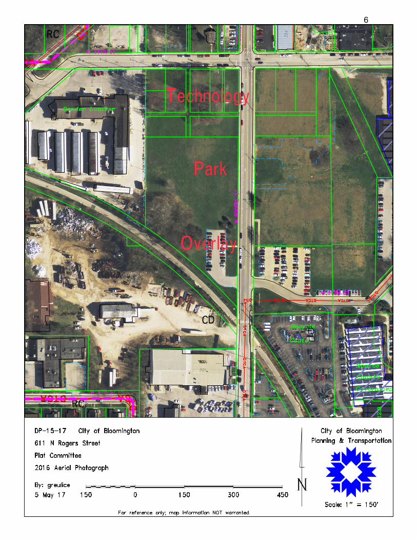
1351 W. Tapp Road REQUEST: The petitioner is requesting preliminary and final plat approval of a 2 lot subdivision of 2.79 acres. REPORT: The subject property is located on the west side of N. Rogers Street between W. 11th Street and the B-Line Trail. The property is 2.79 acres of a larger 8.4 acre holding owned by the City of Bloomington Redevelopment Commission. This site is part of the larger 12 acre Trades District (formerly Showers Technology Park). The property is zoned Commercial Downtown (CD) and is within the Showers Technology Park Overlay (STPO). The petitioner proposes to construct a 4-story multi-family building and this subdivision request would allow the creation of a separate Lot #1 for that building. A site plan for that building was approved under SP-29-16. No approvals have been given for Lot #2 parcel that will be created as a result of this subdivision. SITE PLAN REVIEW: Right of Way: With the site plan approval, the Plan Commission acknowledged that there would be only an additional 8.5’ of right-of-way dedicated for Rogers Street for a total of 33.5’ of right-of-way as opposed to the required 40’ from centerlihne. The amount of right-of-way dedicated still allows for the on-street parking spaces, tree plot, and sidewalk to be located in the right-of-way.
BMC (20.09.210(d)(2)(A)(i) allows for waivers from subdivision standards. The Department finds that the requested waiver from the required 40’ of dedicated right-of-way for Rogers Street to only dedicate 33.5’ of right-of-way is appropriate. The request to dedicate less than the required right-of-way stems from the desire to place the building closer to the street. All of the required public facilities including on-street parking, street trees, and sidewalk will be located in the right-of-way.
Utilities: A blanket utility easement will be recorded with this plat and specific utility easements will be recorded as the final site plan is finalized. The Utility Department is okay with this blanket easement. Access: With the site plan approval it was required that this parcel also plat an access easement to the lot to the north. That access easement will also be recorded once the final site plan is finalized.
3

RECOMMENDATION: Based on the written findings above, staff recommends approval of DP-15-17 with the associated waiver with the following conditions:
1. Easements must be provided for all utility lines prior to issuance of a grading permit.
2. Approved per terms and conditions of SP-29-16.
4

5
6

7

FLOOD ZONE:FEMA HAS NOT DESIGNATED THIS PROPERTY AS A FLOODHAZARD AREA, PROPERTY IS LOCATED IN FLOOD ZONE X PERCOMMUNITY PANEL NO. 180169 0141 D DATED DECEMBER 17,2011.
TRADES DISTRICT WEST PHASE ONESUBDIVISION-PRELIMINARY PLAT
A PART OF THE EAST HALF OF SECTION 32TOWNSHIP 9 NORTH, RANGE 1 WEST
MONROE COUNTY, INDIANA
AUDITOR'S STAMP
LOCATION MAP
PRELIMIN
ARY
REDUCED-
NOT TO SCALE
OWNER CERTIFICATIONThe City of Bloomington Redevelopment Commission, Owner of the real estate shownand described herein, do hereby certify, layoff, and plat (2) lots, numbered 1 and 2.
Rights-of-way not heretofore dedicated are hereby dedicated to Monroe County,Indiana. In accordance with this plat and certificate, this plat shall be known as PEDCORSubdivision.
IN WITNESS WHEREOF, the undersigned Owners set their hand and seal this_____ day of
___________________________, 2017.
___________________________ __________________________By: Representative of the City of Bloomington Redevelopment Commission
STATE OF INDIANACOUNTY OF MONROE
Before me, a Notary Public in and for said County and State, personally appeared______________, as a representative of the City of Bloomington RedevelopmentCommission, who acknowledged the execution of the above referenced plat, to be theirvoluntary act for the uses and purposes therein set forth.
WITNESS my hand and Notarial Seal this ____day of ______________________, 2017.
________________________________Notary Public (Signature)
________________________________Notary Public (Printed Name)
My Commission Expires:____________________________
My County of Residence:____________________________
The City of Bloomington Redevelopment Commission, Owner of the real estate shownand described herein, do hereby certify, layoff, and plat (2) lots, numbered 1 and 2.
Rights-of-way not heretofore dedicated are hereby dedicated to Monroe County,Indiana. In accordance with this plat and certificate, this plat shall be known as PEDCORSubdivision.
IN WITNESS WHEREOF, the undersigned Owners set their hand and seal this_____ day of
___________________________, 2017.
___________________________ ____________________________By: Representative of the City of Bloomington Redevelopment Commission
STATE OF INDIANACOUNTY OF MONROE
Before me, a Notary Public in and for said County and State, personally appeared______________, as a representative of the City of Bloomington RedevelopmentCommission, owners, who acknowledged the execution of the above referenced plat, tobe their voluntary act for the uses and purposes therein set forth.
WITNESS my hand and Notarial Seal this ____day of _____________________, 2017.
________________________________Notary Public (Signature)
________________________________Notary Public (Printed Name)
My Commission Expires:____________________________
My County of Residence:____________________________
Under the authority of Chapter 174, Acts of 1947, as amended General Assembly of theState of Indiana, and the Monroe County Subdivision Ordinance, this plat was processedas an Administrative Type "E" Subdivision on______________________________, 2017.
____________________________XXX XXXX, SecretaryMonroe County Plan Commission
____________________________XXX XXXX, PresidentMonroe County Plan Commission
OWNER/DEVELOPER:City of Bloomington Redevelopment Commission401 West 17th StreetBloomington, IN 47404Phone: 812-349-3420
RECORD INFORMATION:City of Bloomington Redevelopment CommissionInstrument Number 201101208853-05-32-100-018.000-005, 53-05-32-100-036.000-005,53-05-32-100-036.000-005
ZONING:Subject: CDAdjoiners: CD
S:\jobs\9301-9400\9371 TECH PARK-PEDCOR\DRAW\9371_TECH PARK-PEDCOR PLAT_CARLSON.dwg
OWNER/DEVELOPER:Owner 2A & Owner 2B4215 N. Baugh RoadBloomington, IN 47408Phone: 812-
RECORD INFORMATION:Owner 2A & Owner 2BINST. NO. 200201021653-05-14-400-035.000-004
ZONING:Subject: AG/RRAdjoiners: AG/RR
SCALE 1"=60'
60 30 0 60
LEGEND:5/8" REBAR WITH CAP STAMPED"BRCJ INC 6892 IN" SET FLUSH
NOTES:1. FIELD WORK PERFORMED MARCH 2014 THROUGH OCTOBER, 2016 .2. ALL REBAR SET ARE 5
8 INCH WITH YELLOW PLASTIC CAP STAMPED"BRCJ INC 6892IN"
3. BEARINGS SHOWN HEREON ARE BASED UPON GRID NORTHESTABLISHED FROM STATIC GPS OBSERVATIONS DATED SEPTEMBER13, 2016 AND POST-PROCESSED USING OPUS (NGS ONLINEPOSITIONING USER SERVICE). REFERENCE FRAME NAD 83(2011)EPOCH 2010.0000, INDIANA STATE PLANE COORDINATES ZONE 1302WEST, U.S. SURVEY FEET. THESE COORDINATES DIFFER BY AS MUCHAS 2.0 FEET FROM THE PUBLISHED DATA ESTABLISHED BY THE CITY OFBLOOMINGTON UTILITIES CONTROL MONUMENTATION SURVEYDATED APRIL 30, 1998.
4. THIS PLAT IS NOT COMPLETE WITHOUT THE ASSOCIATEDRETRACEMENT BOUNDARY SURVEY AND REPORT OF SURVEYRECORDED SEPARATELY AS INSTRUMENT NO. 2017003363.
LEGAL DESCRIPTIONA part of the East half of Section 32, Township 9 North, Range 1 West, Monroe County, Indiana, and described as follows:
Commencing at the intersection of the south alley line, said alley running East and West south of Lots 46, 47, 48, 49 and 50in Maple Heights Second Addition to the City of Bloomington, and the west line of North Rogers Street, said point being 144feet south of West Eleventh Street; thence coincident with said south alley line SOUTH 89 degrees 35 minutes 04 secondsWEST a distance of 8.50 feet to the Point of Beginning; thence leaving said south alley line SOUTH 00 degrees 33 minutes 32seconds WEST a distance of 573.70 feet to the north right-of-way line of the CSX Railroad Corridor, said point being on anon-tangent curve having a radius of 1490.96 feet; thence northwesterly along said curve 364.16 feet (chord bearing NORTH48 degrees 58 minutes 52 seconds WEST a distance of 363.26 feet); thence leaving said north right-of-way line NORTH 00degrees 33 minutes 43 seconds EAST a distance of 333.28 feet to the south line of the aforementioned alley; thencecoincident with said south line NORTH 89 degrees 35 minutes 04 seconds EAST a distance of 124.07 feet to the intersectionof said south line and the southerly extension of the west line of a 12 foot wide north-south alley extended south betweenLots 47 and 48 in Maple Heights Second Addition to the City of Bloomington; thence coincident with said southerly extensionof said west line SOUTH 00 degrees 34 minutes 45 seconds WEST a distance of 62.00 feet to the southwest corner of saidnorth-south 12 foot alley; thence coincident with the South line of said alley NORTH 89 degrees 35 minutes 04 seconds EASTa distance of 12.00 feet to the southeast corner of said alley; thence coincident with the southerly extension of the east lineof said 12 foot wide alley NORTH 00 degrees 34 minutes 45 seconds EAST a distance of 62.00 feet to the south line of theaforementioned East and West alley; thence coincident with said south line NORTH 89 degrees 35 minutes 04 seconds EAST adistance of 140.34 feet to the point of beginning and containing 2.798 acres, more or less.
NOT TO SCALEN 39.171951
W -86.539073
REPORT OF SURVEYA report of survey was included with the retracement boundary survey of the subject property by Ben E. Bledsoe ofBledsoe Riggert Guerrettaz, Inc., dated August 10, 2011 and recorded in the Office of the Recorder as Instrument No.2017003363. The purpose of this Subdivision is to divide the subject parcel into Lot 1 and Lot 2 as directed by theproperty owners.
SURVEYOR'S CERTIFICATIONThis survey was executed according to survey requirements contained in Section 1 through 19 of 865 IAC1-12.
This certification does not take into consideration additional facts that an accurate and correct title searchand/or examination might disclose.
Evidence of easements have not been located in the field and are not shown on this survey drawing.
Subject to the above reservation, I hereby certify that the survey work performed on the project shownhereon was performed either by me or under my direct supervision and control and that all informationshown is true and correct to the best of my knowledge and belief.
"I AFFIRM, UNDER THE PENALTIES FOR PERJURY, THAT I HAVE TAKEN REASONABLE CARE TO REDACT EACHSOCIAL SECURITY NUMBER IN THIS DOCUMENT, UNLESS REQUIRED BY LAW."
Certified May 5, 2017
___________________________________Christopher L. PorterProfessional Surveyor No. LS21200022State of Indiana
SUBJECTPROPERTY
OWNER CERTIFICATIONThe undersigned, the City of Bloomington Redevelopment Commission, being the owner of theabove described real estate, do hereby layoff and plat the same into two lots in accordance withthe plat and certificate.
This plat shall be known and designated as Trades District West Phase One Subdivision.
In Witness Whereof, the City of Bloomington Redevelopment Commission, have executed thisinstrument and caused their names to be subscribed thereto, this _____day of_________________________, 2017.
__________________________________________________The City of Bloomington Redevelopment Commission
By________________________________________________
STATE OF INDIANA COUNTY OF MONROE
Before me, a Notary Public for said County and State, _________________________, personallyappeared and acknowledged the execution of this instrument this _____day of_________________________, 2017.
__________________________________________________Notary Signature
My commission expires:______________________________
County of Residence:_________________________________
APPROVED BY THE CITY PLAT COMMITTEE AT A MEETING HELD: MAY 8, 2017
________________________________________________________________________________Terri Porter, Director Planning & Transportation Department
________________________________________________________________________________Adam Wason, Director of Public Works
BMP EASEMENT DETAILS
EASEMENT DEFINITIONSDRAINAGE EASEMENT:A. Shall be required for any surface swales or other minor improvements that
are intended for maintenance by the lots on which they are located.B. Shall prohibit any alteration within the easement that would hinder or
redirect flow.C. Shall provide that the owner of the lot on which the easement is placed shall
be responsible for maintenance of the drainage features within sucheasement.
D. Shall be enforceable by the City Utilities Department and by owners ofproperties that are adversely affected by conditions within the easement.
E. Shall allow the City Utilities Department to enter upon the easement for thepurpose of maintenance, to charge the costs of such maintenance to theresponsible parties, to construct drainage facilities within the easement, andto assume responsibility for the drainage features at its discretion.
UTILITY EASEMENT:A. Shall allow both private and public utility providers access associated with
the installation, maintenance, repair or removal of utility facilities.B. Prohibits the placement of any unauthorized obstruction within theeasement area.
SCALE 1"=40'
SCALE 1"=40'
EXISTING CONTOUR
S:\jobs\9301-9400\9371 TECH PARK-PEDCOR\DRAW\9371_TECH PARK-PEDCOR PLAT_CARLSON.dwg
8

FLOOD ZONE:FEMA HAS NOT DESIGNATED THIS PROPERTY AS A FLOODHAZARD AREA, PROPERTY IS LOCATED IN FLOOD ZONE X PERCOMMUNITY PANEL NO. 180169 0141 D DATED DECEMBER 17,2011.
TRADES DISTRICT WEST PHASEONE SUBDIVISION - FINAL PLATA PART OF THE EAST HALF OF SECTION 32
TOWNSHIP 9 NORTH, RANGE 1 WESTMONROE COUNTY, INDIANA
AUDITOR'S STAMP
LOCATION MAP
PRELIMIN
ARY
REDUCED-
NOT TO SCALE
OWNER CERTIFICATIONThe City of Bloomington Redevelopment Commission, Owner of the real estate shownand described herein, do hereby certify, layoff, and plat (2) lots, numbered 1 and 2.
Rights-of-way not heretofore dedicated are hereby dedicated to Monroe County,Indiana. In accordance with this plat and certificate, this plat shall be known as PEDCORSubdivision.
IN WITNESS WHEREOF, the undersigned Owners set their hand and seal this_____ day of
___________________________, 2017.
___________________________ __________________________By: Representative of the City of Bloomington Redevelopment Commission
STATE OF INDIANACOUNTY OF MONROE
Before me, a Notary Public in and for said County and State, personally appeared______________, as a representative of the City of Bloomington RedevelopmentCommission, who acknowledged the execution of the above referenced plat, to be theirvoluntary act for the uses and purposes therein set forth.
WITNESS my hand and Notarial Seal this ____day of ______________________, 2017.
________________________________Notary Public (Signature)
________________________________Notary Public (Printed Name)
My Commission Expires:____________________________
My County of Residence:____________________________
The City of Bloomington Redevelopment Commission, Owner of the real estate shownand described herein, do hereby certify, layoff, and plat (2) lots, numbered 1 and 2.
Rights-of-way not heretofore dedicated are hereby dedicated to Monroe County,Indiana. In accordance with this plat and certificate, this plat shall be known as PEDCORSubdivision.
IN WITNESS WHEREOF, the undersigned Owners set their hand and seal this_____ day of
___________________________, 2017.
___________________________ ____________________________By: Representative of the City of Bloomington Redevelopment Commission
STATE OF INDIANACOUNTY OF MONROE
Before me, a Notary Public in and for said County and State, personally appeared______________, as a representative of the City of Bloomington RedevelopmentCommission, owners, who acknowledged the execution of the above referenced plat, tobe their voluntary act for the uses and purposes therein set forth.
WITNESS my hand and Notarial Seal this ____day of _____________________, 2017.
________________________________Notary Public (Signature)
________________________________Notary Public (Printed Name)
My Commission Expires:____________________________
My County of Residence:____________________________
Under the authority of Chapter 174, Acts of 1947, as amended General Assembly of theState of Indiana, and the Monroe County Subdivision Ordinance, this plat was processedas an Administrative Type "E" Subdivision on______________________________, 2017.
____________________________XXX XXXX, SecretaryMonroe County Plan Commission
____________________________XXX XXXX, PresidentMonroe County Plan Commission
OWNER/DEVELOPER:City of Bloomington Redevelopment Commission401 West 17th StreetBloomington, IN 47404Phone: 812-349-3420
RECORD INFORMATION:City of Bloomington Redevelopment CommissionInstrument Number 201101208853-05-32-100-018.000-005, 53-05-32-100-036.000-005,53-05-32-100-036.000-005
ZONING:Subject: CDAdjoiners: CD
S:\jobs\9301-9400\9371 TECH PARK-PEDCOR\DRAW\9371_TECH PARK-PEDCOR PLAT_CARLSON.dwg
OWNER/DEVELOPER:Owner 2A & Owner 2B4215 N. Baugh RoadBloomington, IN 47408Phone: 812-
RECORD INFORMATION:Owner 2A & Owner 2BINST. NO. 200201021653-05-14-400-035.000-004
ZONING:Subject: AG/RRAdjoiners: AG/RR
SCALE 1"=60'
60 30 0 60
LEGEND:5/8" REBAR WITH CAP STAMPED"BRCJ INC 6892 IN" SET FLUSH
NOTES:1. FIELD WORK PERFORMED MARCH 2014 THROUGH OCTOBER, 2016 .2. ALL REBAR SET ARE 5
8 INCH WITH YELLOW PLASTIC CAP STAMPED"BRCJ INC 6892IN"
3. BEARINGS SHOWN HEREON ARE BASED UPON GRID NORTHESTABLISHED FROM STATIC GPS OBSERVATIONS DATED SEPTEMBER13, 2016 AND POST-PROCESSED USING OPUS (NGS ONLINEPOSITIONING USER SERVICE). REFERENCE FRAME NAD 83(2011)EPOCH 2010.0000, INDIANA STATE PLANE COORDINATES ZONE 1302WEST, U.S. SURVEY FEET. THESE COORDINATES DIFFER BY AS MUCHAS 2.0 FEET FROM THE PUBLISHED DATA ESTABLISHED BY THE CITY OFBLOOMINGTON UTILITIES CONTROL MONUMENTATION SURVEYDATED APRIL 30, 1998.
4. THIS PLAT IS NOT COMPLETE WITHOUT THE ASSOCIATEDRETRACEMENT BOUNDARY SURVEY AND REPORT OF SURVEYRECORDED SEPARATELY AS INSTRUMENT NO. 2017003363.
LEGAL DESCRIPTIONA part of the East half of Section 32, Township 9 North, Range 1 West, Monroe County, Indiana, and described as follows:
Commencing at the intersection of the south alley line, said alley running East and West south of Lots 46, 47, 48, 49 and 50in Maple Heights Second Addition to the City of Bloomington, and the west line of North Rogers Street, said point being 144feet south of West Eleventh Street; thence coincident with said south alley line SOUTH 89 degrees 35 minutes 04 secondsWEST a distance of 8.50 feet to the Point of Beginning; thence leaving said south alley line SOUTH 00 degrees 33 minutes 32seconds WEST a distance of 573.70 feet to the north right-of-way line of the CSX Railroad Corridor, said point being on anon-tangent curve having a radius of 1490.96 feet; thence northwesterly along said curve 364.16 feet (chord bearing NORTH48 degrees 58 minutes 52 seconds WEST a distance of 363.26 feet); thence leaving said north right-of-way line NORTH 00degrees 33 minutes 43 seconds EAST a distance of 333.28 feet to the south line of the aforementioned alley; thencecoincident with said south line NORTH 89 degrees 35 minutes 04 seconds EAST a distance of 124.07 feet to the intersectionof said south line and the southerly extension of the west line of a 12 foot wide north-south alley extended south betweenLots 47 and 48 in Maple Heights Second Addition to the City of Bloomington; thence coincident with said southerly extensionof said west line SOUTH 00 degrees 34 minutes 45 seconds WEST a distance of 62.00 feet to the southwest corner of saidnorth-south 12 foot alley; thence coincident with the South line of said alley NORTH 89 degrees 35 minutes 04 seconds EASTa distance of 12.00 feet to the southeast corner of said alley; thence coincident with the southerly extension of the east lineof said 12 foot wide alley NORTH 00 degrees 34 minutes 45 seconds EAST a distance of 62.00 feet to the south line of theaforementioned East and West alley; thence coincident with said south line NORTH 89 degrees 35 minutes 04 seconds EAST adistance of 140.34 feet to the point of beginning and containing 2.798 acres, more or less.
NOT TO SCALEN 39.171951
W -86.539073
REPORT OF SURVEYA report of survey was included with the retracement boundary survey of the subject property by Ben E. Bledsoe ofBledsoe Riggert Guerrettaz, Inc., dated August 10, 2011 and recorded in the Office of the Recorder as Instrument No.2017003363. The purpose of this Subdivision is to divide the subject parcel into Lot 1 and Lot 2 as directed by theproperty owners.
SURVEYOR'S CERTIFICATIONThis survey was executed according to survey requirements contained in Section 1 through 19 of 865 IAC1-12.
This certification does not take into consideration additional facts that an accurate and correct title searchand/or examination might disclose.
Evidence of easements have not been located in the field and are not shown on this survey drawing.
Subject to the above reservation, I hereby certify that the survey work performed on the project shownhereon was performed either by me or under my direct supervision and control and that all informationshown is true and correct to the best of my knowledge and belief.
"I AFFIRM, UNDER THE PENALTIES FOR PERJURY, THAT I HAVE TAKEN REASONABLE CARE TO REDACT EACHSOCIAL SECURITY NUMBER IN THIS DOCUMENT, UNLESS REQUIRED BY LAW."
Certified May 5, 2017
___________________________________Christopher L. PorterProfessional Surveyor No. LS21200022State of Indiana
SUBJECTPROPERTY
OWNER CERTIFICATIONThe undersigned, the City of Bloomington Redevelopment Commission, being the owner of theabove described real estate, do hereby layoff and plat the same into two lots in accordance withthe plat and certificate.
This plat shall be known and designated as Trades District West Phase One Subdivision.
In Witness Whereof, the City of Bloomington Redevelopment Commission, have executed thisinstrument and caused their names to be subscribed thereto, this _____day of_________________________, 2017.
__________________________________________________The City of Bloomington Redevelopment Commission
By________________________________________________
STATE OF INDIANA COUNTY OF MONROE
Before me, a Notary Public for said County and State, _________________________, personallyappeared and acknowledged the execution of this instrument this _____day of_________________________, 2017.
__________________________________________________Notary Signature
My commission expires:______________________________
County of Residence:_________________________________
APPROVED BY THE CITY PLAT COMMITTEE AT A MEETING HELD: MAY 8, 2017
________________________________________________________________________________Terri Porter, Director Planning & Transportation Department
________________________________________________________________________________Adam Wason, Director of Public Works
BMP EASEMENT DETAILS
EASEMENT DEFINITIONSDRAINAGE EASEMENT:A. Shall be required for any surface swales or other minor improvements that
are intended for maintenance by the lots on which they are located.B. Shall prohibit any alteration within the easement that would hinder or
redirect flow.C. Shall provide that the owner of the lot on which the easement is placed shall
be responsible for maintenance of the drainage features within sucheasement.
D. Shall be enforceable by the City Utilities Department and by owners ofproperties that are adversely affected by conditions within the easement.
E. Shall allow the City Utilities Department to enter upon the easement for thepurpose of maintenance, to charge the costs of such maintenance to theresponsible parties, to construct drainage facilities within the easement, andto assume responsibility for the drainage features at its discretion.
UTILITY EASEMENT:A. Shall allow both private and public utility providers access associated with
the installation, maintenance, repair or removal of utility facilities.B. Prohibits the placement of any unauthorized obstruction within theeasement area.
SCALE 1"=40'
SCALE 1"=40'
EXISTING CONTOUR
S:\jobs\9301-9400\9371 TECH PARK-PEDCOR\DRAW\9371_TECH PARK-PEDCOR PLAT_CARLSON.dwg
9

Bloo
min
gton
, Ind
iana
9/30
/201
6
Mov
ing
Forw
ard
W 1
0th
Stre
et &
N r
oger
S Str
eet
SITE
PLA
N
H2O
H2O
H2O
OH
WO
HW
OH
WO
HW
OH
WO
HW
OHWOHW OHW OHW OHW OHW OHW OHW OHW OHW OHW OHW OHW OHW OHW OHW OHW OHW OHW
OHW OHW OHW OHW OHW OHW OHW OHW OHW OHW OHW OHW OHW OHW OHW
OHW OHW OHW OHW OHW OHW OHW OHW OHW OHW OHW OHW OHW OHW
X
XXXXXXXXXXXXXXXXXXX
SA
NIT
AR
Y M
HTC
=788
.99'
N 8
"PV
CIN
V=7
83.8
7'S
8"P
VC
INV
=783
.77'
SANSANSANSANSANSANSANSANSANSANSANSANSANSANSANSANSANSANSANSANSANSANSANSANSANSANSAN
SANSANSANSANSANSANSANSANSANSANSANSANSANSANSANSANSANSANSANSANSAN
CU
RB
INLE
TTC
=787
.04'
E 6
"CLA
YIN
V=7
84.5
4'
SAN SAN
SA
NIT
AR
Y M
H T
C=7
84.0
4'N
8"P
VC
INV
=778
.94'
S 8
"PV
C IN
V=7
78.8
5'
CA
TCH
BA
SIN
TC
=783
.88'
NW
18"
RC
P IN
V=7
80.6
8'S
E 2
4" V
CP
INV
=780
.48'
ST
ST
ST
ST
ST
N. ROGERS STREET (49' R/W )
UT
UT
UT
UT
UT
UT
UT
UT
H2O
H2O H2O H2O H2O H2O H2O H2O H2O H2O H2O H2O H2O H2O H2O H2O H2O H2O H2O H2O H2O H2O H2O H2O H2O H2O H2O H2O H2O H2O H2O H2O H2O H2O H2O H2O H2O H2O H2O H2O H2O H2O H2O H2O H2O H2O H2O H2O H2O H2O H2O H2O
B-LIN
E TRAIL
BD
U F
O
BD
U F
O
H2O H2O H2O H2O
8" WATER
8" WATER
H2O
SM
ITH
VIL
LE
SM
ITH
VIL
LE
H2O
H2O
18" R
CP
INV
= 7
81.1
1'
UT
UT
UT
UT
UT
UT
UT
UT
UT
UT
UT
UT
UT
UT
UT
UT
UT
UT
UT
UT
UT
UT
UT
UT
UT
UT
UT
UT
UT
UT
UT
UT
UT
UT
UT
UT
UT
UT
UT
UT
UT
UT
UT
UT
UT
GASGASGASGASGASGASGASGASGASGASGASGASGASGASGASGASGASGASGASGASGASGASGASGASGASGASGASGASGASGASGAS
UT UT UT UT UT UT UT UT UT UT UT UT UT UT UT UT UT UT UT UT UT UT UT UT UT UT UT UT UT UT UT UT UT UT UT UT UT UT UT UT UT UT UT UT UT UT UT UT UT UT UT
STORM M
ANHOLE
TC=7
88.58
'
NW &
SE
36" C
MP
INV=
781.8
7'
ST
ST
ST
ST
ST
ST
ST
ST
ST
ST
ST
ST
ST
ST
ST
ST
ST
ST
ST
ST
ST
ST
ST
ST
ST
ST
ST
ST
ST
ST
ST
ST
ST
ST
ST
ST
ST
ST
ST
STO
RM
MA
NH
OLE
TC=7
85.1
3'N
W &
SE
36"
CM
PIN
V=7
80.0
8'S
W 1
8"C
MP
INV
=780
.83'
CA
TCH
BA
SIN
TC=7
83.0
2'N
E 1
8" C
MP
INV
=780
.37'
ST
ST
ST
STO
RM
MA
NH
OLE
TC =
783
.70'
NW
& S
E 3
6"C
MP
INV
=779
.10'
UTUTUTUTUTUTUTUTUTUTUTUT
UT
UT
UT UT UT UT UT UT UT UT UT UT UT UT UT UT UT UT UT UTUT
UT UT UT UT UT UT UT UT UT UT UT UT UT UT UT UT UT UT UT UT UTUT UT UT UT UT UT UT UT UT UT UT UT UT UT UT
N 00°27'40" E20.03'
LOADING ZONE/FIRE ACCESS
Know what's
R
N
PROJECT NUMBER
DRAWING NUMBER
SHEET OF
SCALE:
DWN BY:CHKD. BY:
REVI
SION
S
DATE:
WIL
LIAM
S CR
EEK
CONS
ULTI
NG
619
N. P
ENNS
YLVA
NIA
STRE
ETIN
DIAN
APOL
IS, I
NDIA
NA 4
6204
Ph: (
317)
423
-069
0in
fo@
will
iam
scre
ek.n
et
PROPOSED CONTOUR
PROPOSED STORM SEWER
PROPOSED STORM STRUCTURE
PROPOSED UNDERDRAIN/SSD
EXISTING CONTOUR
PROPOSED SANITARY SEWER CLEANOUT
PROPOSED SANITARY SEWER MAIN/LATERAL
PROPOSED BMP OUTLINE
LIMITS OF DISTURBANCE
PROPOSED WATER SERVICE
1. MANHOLE OR CLEAN-OUT CASTINGS MAY NEED TO BE ELEVATED AFTER FINAL GRADING TO INSUREDRAINAGE AWAY FROM STRUCTURES.
2. PAVEMENT OR CONCRETE, INCLUDING DRIVEWAYS AND SIDEWALKS, MUST NOT BE CONSTRUCTED ONOR WITHIN ONE (1) FOOT HORIZONTAL DISTANCE OF SANITARY SEWER CASTINGS.
3. ALL ROUGH GRADING MUST BE FINISHED TO WITHIN ONE (1) FOOT OF FINAL GRADE PRIOR TO THE STARTOF CONSTRUCTION OF THE SANITARY OR STORMSEWER INFRASTRUCTURE.
4. AT THE INSPECTOR’S DISCRETION, A CONCRETE CRADLE MAY BE REQUIRED FOR ALL LATERAL/UTILITYCROSSINGS.
5. CONTRACTOR MUST FIELD VERIFY INVERT ELEVATIONS OF EXISTING STRUCTURES PRIOR TOCONSTRUCTION. IF A VARIATION EXISTS, THEN CONTACT THE ENGINEER AND UTILITY COMPANYIMMEDIATELY.
6. SANITARY SEWER FACILITIES, INCLUDING MAINS AND LATERALS, MUST MAINTAIN FIVE (5) FEET OF COVERFROM THE TOP OF PIPE TO GRADE. IF ADEQUATE COVER CAN NOT BE MAINTAINED, THEN CONCRETECAPPING MUST BE INSTALLED WHEN COVER IS FOUR (4) TO FIVE (5) FEET AND CONCRETE ENCASEMENTMUST BE INSTALLED WHEN COVER IS THREE (3) TO FOUR (4) FEET. UNDER NO CIRCUMSTANCES WILLCOVER BE PERMITTED TO BE LESS THAN THREE (3) FEET.
7. ALL BENCH WALLS (WHERE INDICATED) SHALL EXTEND TO THE CROWN OF THE HIGHEST INFLUENT PIPE.8. ALL UTILITY CROSSINGS OF EXISTING PAVEMENTS SHALL BE MADE UTILIZING TRENCHLESS
CONSTRUCTION. OPEN CUTS WITHIN EXISTING PAVEMENT SHALL NOT BE ALLOWED.9. ALL UNDERDRAIN SHALL BE DUAL-WALL, PERFORATED PIPE UNLESS OTHERWISE INDICATED.
PEDC
OR IN
VEST
MEN
TS, L
LC77
0 3R
D AV
ENUE
, S.W
.CA
RMEL
, IND
IANA
460
32
UTIL
ITY
PLAN
MOV
ING
FORW
ARD
MUL
TI-F
AMIL
YDE
VELO
PMEN
T77
0 3R
D AV
ENUE
, S.W
.CA
RMEL
, IND
IANA
460
32
C5.0
01.1109.A.1
KFPAER
1" = 20'08/26/2016
2 2
1. A CARBON FILTER (OR SIMILAR) SHALL BE INSTALLED INSIDE THE BUILDING'S MECHANICAL ROOM ON THEEFFLUENT SIDE OF THE GREYWATER STORAGE TANK FOR ODOR CONTROL.
2. UV DISINFECTION UNIT(S) SHALL BE INSTALLED INSIDE THE BUILDING'S MECHANICAL ROOM ON THEEFFLUENT SIDE OF THE ODOR CONTROL FILTER.
3. ALL GREYWATER REUSE SHALL BE DYED PURPLE USING A DYE-INJECTION UNIT.4. ALL REUSE PLUMBING INSIDE THE BUILDING SHALL BE PURPLE OR CLEARLY MARKED AS NON-POTABLE
TO PREVENT CROSS-CONNECTIONS WITH POTABLE SUPPLY LINES.5. THE GREYWATER STORAGE TANK, RECIRCULATION PUMPS, AND ALL OTHER RELATED COMPONENTS
SHALL BE LOCATED INSIDE THE BUILDING'S MECHANICAL ROOM.6. THERE SHALL BE AN AIR GAP BETWEEN THE GREYWATER STORAGE TANK AND THE BACKUP MUNICIPAL
WATER SUPPLY.7. THERE SHALL BE AN OVERFLOW CONNECTION TO THE SANITARY SEWER LATERAL FROM THE
GREYWATER STORAGE TANK.8. PLEASE NOTE, ONLY GREYWATER FROM SHOWERS, LAVATORIES, AND WASHING MACHINES SHALL BE
PLUMBED TO THE ECOLOGICAL TREATMENT SYSTEM.
PROPOSED WATER METER PIT
PROPOSED SWALE
PROPOSED SANITARY SEWER STRUCTURE
PROPOSED WATER VALVEPROPOSED ELECTRIC SERVICE
10

Bloo
min
gton
, Ind
iana
9/30
/201
6
Mov
ing
Forw
ard
W 1
0th
Stre
et &
N r
oger
S Str
eet
UTIL
ITY
PLAN
X
XXXXXXXXXXXXXXXXXXX
W W W W W W W W W W W W W W W W W W W W W W W
W
LOADING ZONE/FIRE ACCESS
Know what's
R
N
PROJECT NUMBER
DRAWING NUMBER
SHEET OF
SCALE:
DWN BY:CHKD. BY:
REVI
SION
S
DATE:
WIL
LIAM
S CR
EEK
CONS
ULTI
NG
619
N. P
ENNS
YLVA
NIA
STRE
ETIN
DIAN
APOL
IS, I
NDIA
NA 4
6204
Ph: (
317)
423
-069
0in
fo@
will
iam
scre
ek.n
et
PROPOSED STORM SEWER
PROPOSED STORM STRUCTURE
PROPOSED UNDERDRAIN/SSD
PROPOSED SANITARY SEWER CLEANOUT
PROPOSED SANITARY SEWER MAIN/LATERAL
PROPOSED BMP OUTLINE
PROPOSED WATER SERVICE
1. MANHOLE OR CLEAN-OUT CASTINGS MAY NEED TO BE ELEVATED AFTER FINAL GRADING TO INSUREDRAINAGE AWAY FROM STRUCTURES.
2. PAVEMENT OR CONCRETE, INCLUDING DRIVEWAYS AND SIDEWALKS, MUST NOT BE CONSTRUCTED ONOR WITHIN ONE (1) FOOT HORIZONTAL DISTANCE OF SANITARY SEWER CASTINGS.
3. ALL ROUGH GRADING MUST BE FINISHED TO WITHIN ONE (1) FOOT OF FINAL GRADE PRIOR TO THE STARTOF CONSTRUCTION OF THE SANITARY OR STORMSEWER INFRASTRUCTURE.
4. AT THE INSPECTOR’S DISCRETION, A CONCRETE CRADLE MAY BE REQUIRED FOR ALL LATERAL/UTILITYCROSSINGS.
5. CONTRACTOR MUST FIELD VERIFY INVERT ELEVATIONS OF EXISTING STRUCTURES PRIOR TOCONSTRUCTION. IF A VARIATION EXISTS, THEN CONTACT THE ENGINEER AND UTILITY COMPANYIMMEDIATELY.
6. SANITARY SEWER FACILITIES, INCLUDING MAINS AND LATERALS, MUST MAINTAIN FIVE (5) FEET OF COVERFROM THE TOP OF PIPE TO GRADE. IF ADEQUATE COVER CAN NOT BE MAINTAINED, THEN CONCRETECAPPING MUST BE INSTALLED WHEN COVER IS FOUR (4) TO FIVE (5) FEET AND CONCRETE ENCASEMENTMUST BE INSTALLED WHEN COVER IS THREE (3) TO FOUR (4) FEET. UNDER NO CIRCUMSTANCES WILLCOVER BE PERMITTED TO BE LESS THAN THREE (3) FEET.
7. ALL BENCH WALLS (WHERE INDICATED) SHALL EXTEND TO THE CROWN OF THE HIGHEST INFLUENT PIPE.8. ALL UTILITY CROSSINGS OF EXISTING PAVEMENTS SHALL BE MADE UTILIZING TRENCHLESS
CONSTRUCTION. OPEN CUTS WITHIN EXISTING PAVEMENT SHALL NOT BE ALLOWED.9. ALL UNDERDRAIN SHALL BE DUAL-WALL, PERFORATED PIPE UNLESS OTHERWISE INDICATED.
PEDC
OR IN
VEST
MEN
TS, L
LC77
0 3R
D AV
ENUE
, S.W
.CA
RMEL
, IND
IANA
460
32
UTIL
ITY
PLAN
MOV
ING
FORW
ARD
MUL
TI-F
AMIL
YDE
VELO
PMEN
T77
0 3R
D AV
ENUE
, S.W
.CA
RMEL
, IND
IANA
460
32
C5.0
01.1109.A.1
KFPDAM
1" = 20'09/29/2016
2 5
1. A CARBON FILTER (OR SIMILAR) SHALL BE INSTALLED INSIDE THE BUILDING'S MECHANICAL ROOM ON THEEFFLUENT SIDE OF THE GREYWATER STORAGE TANK FOR ODOR CONTROL.
2. UV DISINFECTION UNIT(S) SHALL BE INSTALLED INSIDE THE BUILDING'S MECHANICAL ROOM ON THEEFFLUENT SIDE OF THE ODOR CONTROL FILTER.
3. ALL GREYWATER REUSE SHALL BE DYED PURPLE USING A DYE-INJECTION UNIT.4. ALL REUSE PLUMBING INSIDE THE BUILDING SHALL BE PURPLE OR CLEARLY MARKED AS NON-POTABLE
TO PREVENT CROSS-CONNECTIONS WITH POTABLE SUPPLY LINES.5. THE GREYWATER STORAGE TANK, RECIRCULATION PUMPS, AND ALL OTHER RELATED COMPONENTS
SHALL BE LOCATED INSIDE THE BUILDING'S MECHANICAL ROOM.6. THERE SHALL BE AN AIR GAP BETWEEN THE GREYWATER STORAGE TANK AND THE BACKUP MUNICIPAL
WATER SUPPLY.7. THERE SHALL BE AN OVERFLOW CONNECTION TO THE SANITARY SEWER LATERAL FROM THE
GREYWATER STORAGE TANK.8. PLEASE NOTE, ONLY GREYWATER FROM SHOWERS, LAVATORIES, AND WASHING MACHINES SHALL BE
PLUMBED TO THE ECOLOGICAL TREATMENT SYSTEM.
PROPOSED WATER METER PIT
PROPOSED SWALE
PROPOSED SANITARY SEWER STRUCTURE
PROPOSED WATER VALVEPROPOSED ELECTRIC SERVICEPROPOSED STREET LIGHT
11