2002 Growth Policies Plan - Bloomington, Indiana
116
2002 Growth Policies Plan City of Bloomington 2002 Growth Policies Plan City of Bloomington Adopted: December 19, 2002
Transcript of 2002 Growth Policies Plan - Bloomington, Indiana

2002 GrowthPolicies PlanCity of Bloomington
2002 GrowthPolicies PlanCity of Bloomington
Adopted: December 19, 2002

FOREWORDpage i
PART 1:Policy Essence
page 1
PART 2:The Geography of
the Policiespage 25
PART 3:Critical Subareas
page 41
PART 4:Implementation Strategy
page 69
PART 5:Master Thoroughfare Plan
page 79
APPENDICESpage 96

II C I T Y O F B L O O M I N G T O N , I N D I A N A
Table of Contents
Foreword
Acknowledgments ..................................................... iv
The Growth Policies Plan Vision ................................ v
The Format of the Plan .............................................. ix
Part 1: Policy Essence
The Foundation ........................................................... 1
Priorities & Relationships ........................................... 2
Monitoring the Growth Policies Plan .......................... 3
Guiding Principles Introduction ................................... 4
Compact Urban Form ................................................. 5Compact Urban Form Goal ............................................................ 5Policy 1: Limit the Spatial Extent of Community Growth ............... 5Policy 2: Increase Residential Densities in the Urbanized Area ... 6Policy 3: Redirect Commercial Development ................................. 7
Nurture Environmental Integrity ................................. 8Nurture Environmental Integrity Goal ............................................ 8Policy 1: Enhance Karst Feature Protection ................................. 8Policy 2: Protect Trees and Greenspace from DevelopmentImpacts .......................................................................................... 9Policy 3: Protect and Enhance Water Quality ............................. 10Policy 4: Manage Community-Wide Drainage Impacts ................ 10Policy 5: Promote Environmentally Sensitive Development ........ 11
Leverage Public Capital ............................................ 12Leverage Public Capital Goal ...................................................... 12Policy 1: Comprehensively Evaluate Public Facilities ................. 12Policy 2: Improve the Capital Improvement Planning Process .... 13Policy 3: Link Public Facility Impacts to Development Process .. 13
Mitigate Traffic ......................................................... 14Mitigate Traffic Goal .................................................................... 14Policy 1: Enhance and Expand Public Transit Services ............. 14Policy 2: Enhance Bicycle and Pedestrian TransportationFacilities ....................................................................................... 15Policy 3: Implement Traffic Management Strategies ................... 16
Conserve Community Character .............................. 17Conserve Community Character Goal ........................................ 17Policy 1: Protect and Enhance Neighborhoods .......................... 17Policy 2: Improve Downtown Vitality .......................................... 18Policy 3: Maintain Bloomington’s Historic Fabric ......................... 19
Sustain Economic and Cultural Vibrancy .................. 20Sustain Economic and Cultural Vibrancy Goal ........................... 20Policy 1: Encourage Quality Employment Opportunities forCitizens ........................................................................................ 20Policy 2: Spur Redevelopment Activity ........................................ 21Policy 3: Link Economic Vibrancy with Quality of Life Amenities21
Advance Communication and Coordination .............. 22Advance Communication and Coordination Goal ....................... 22Policy 1: Enhance Intergovernmental Cooperation ..................... 22Policy 2: Develop a More Inclusive Planning Process ................ 23Policy 3: Increase Development Review Effectiveness ............ 23Policy 4: Strengthen Indiana University-City Planning Interaction24
Part 2: The Geography of the Policies
Introduction ............................................................... 25Growth Policies Plan Map .............................................. 27
Downtown ................................................................ 28Intent ............................................................................... 28Land Use ........................................................................ 28Urban Services ............................................................... 28Site Design ..................................................................... 29
Core Residential ........................................................ 30Intent ............................................................................... 30Land Use ........................................................................ 30Urban Services ............................................................... 30Site Design ..................................................................... 30
Urban Residential ..................................................... 31Intent ............................................................................... 31Land Use ........................................................................ 31Urban Services ............................................................... 31Site Design ..................................................................... 31
Conservation Residential ........................................... 32Intent ............................................................................... 32Land Use ........................................................................ 32Urban Services ............................................................... 32Site Design ..................................................................... 32
Neighborhood Activity Center (NAC) ...................... 33Intent ............................................................................... 33Land Use ........................................................................ 33Urban Services ............................................................... 33Site Design ..................................................................... 33
Community Activity Center (CAC) ......................... 35Intent ............................................................................... 35Land Use ........................................................................ 35Urban Services ............................................................... 35Site Design ..................................................................... 35
Regional Activity Center (RAC) .............................. 36Intent ............................................................................... 36Land Use ........................................................................ 36Urban Services ............................................................... 36Site Design ..................................................................... 36
Employment Center ................................................. 37Intent ............................................................................... 37Land Use ........................................................................ 37Urban Services ............................................................... 37Site Design ..................................................................... 37
Public/Semi-Public/Institutional ................................. 38Intent ............................................................................... 38Land Use ........................................................................ 38Urban Services ............................................................... 38Site Design ..................................................................... 38
Parks/Open Space .................................................... 39Intent ............................................................................... 39Land Use ........................................................................ 39Urban Services ............................................................... 39Site Design ..................................................................... 39
Quarry ....................................................................... 40Intent ............................................................................... 40Land Use ........................................................................ 40Urban Services ............................................................... 40Site Design ..................................................................... 40
FOREWORD: Table of Contents
G R O W T H P O L I C I E S P L A N III
Part 3: Critical Subareas
Introduction ............................................................... 41
Subarea Overview .................................................... 42Subarea Location Map ................................................... 43
State Road 37 Corridor ............................................. 44State Road 37 Corridor Map ........................................... 45
Acuff Road/Kinser Pike Subarea ............................. 46Acuff Road/Kinser Pike Subarea Map ............................ 47
State Road 37/Tapp Road Subarea ........................... 48State Road 37/Tapp Road Subarea Map ........................ 49
North College Mall District Subarea ......................... 50North College Mall District Subarea Map ....................... 51
Huntington Farm/Moores Pike Subarea ................... 52Huntington Farm/Moores Pike Subarea Map ................. 53
East Jackson Creek Subarea .................................... 54East Jackson Creek Subarea Map ................................. 55
Winston-Thomas Subarea ......................................... 56Winston-Thomas Subarea Map ..................................... 57
Ramsey Farm Subarea ............................................. 58Ramsey Farm Subarea Map .......................................... 59
Adams Street/Patterson Drive Subarea ................... 60Adams Street/Patterson Drive Subarea Map .................. 61
West 17th Street Subarea .......................................... 62West 17th Street Subarea Map ........................................ 63
Twin Lakes Park North Subarea .............................. 64Twin Lakes Park North Subarea Map ............................. 65
McDoel Switchyard Subarea .................................... 66McDoel Switchyard Subarea Map ................................... 67
Goat Farm Subarea ................................................... 68Goat Farm Subarea Map ................................................ 69
Part 4: Implementation Strategy
Implementation Strategy Introduction ....................... 70
Compact Urban Form Implementation ..................... 71
Nurture Environmental Integrity Implementation ..... 72
Leverage Public Capital Implementation .................. 74
Mitigate Traffic Implementation ............................... 75
Conserve Community Character Implementation ..... 76
Sustain Economic and Cultural VibrancyImplementation ...................................................... 77
Advance Communication and CoordinationImplementation ...................................................... 78
Part 5: Master Thoroughfare Plan
Introduction ............................................................... 79
Relationship to Other Plans and Regulations ............ 80
Purpose of the Master Thoroughfare Plan ............... 80
Street Classifications ................................................. 81
FOREWORD: Table of Contents
Bicycle/Pedestrian Facility Classification ................. 82
Typical Cross Section Introduction ........................... 83
Existing Core Neighborhood ..................................... 84
Neighborhood Streets ............................................... 85
Secondary Collectors ................................................ 86Primary Collectors .................................................... 87
Secondary Arterials .................................................. 88
Primary Arterials ....................................................... 90
Official Thoroughfare Plan Map............................... 92Thoroughfare Plan Map .................................................. 93
Access Control Guidelines ........................................ 94
Appendices
Appendix A: Index .................................................... 96
Appendix B: Glossary ............................................... 99
Appendix C: Community Demographic Profile ...... 101Population Change .......................................................101Population Forecasts ................................................... 102

IV C I T Y O F B L O O M I N G T O N , I N D I A N A
Acknowledgments
The following individuals are recognized for theircontributions to the development of the BloomingtonGrowth Policies Plan.
City of Bloomington MayorJohn Fernandez
City of Bloomington City CouncilAnthony PizzoTim MayerAndy RuffPatricia ColeJason BanachMichael DiekhoffJeffrey WillseyDavid SabbaghChris Gaal
City of Bloomington Plan CommissionBill StuebeScott BurginsSusan FernandesJeffrey WillseyJoe HoffmannMarcia DonnersteinMilan PeceRichard SatnickTom SeeberKurt ZornJonathon HealdRichard Martin
FOREWORD: Acknowledgments
Growth Policies Plan Steering CommitteeJames McNamaraTim MayerBill StuebeAndy RuffKelly BoatmanJoan CochranChris MathieuMarc CornettRichard MartinBarry RubinTom SwaffordMike CarminDavid FergusonJim MurphySteve SmithLinda WilliamsonMary OgleJoyce PolingBrian O’Neill
City Planning Department StaffTom Micuda, AICP, Planning DirectorJoshua Desmond, AICP, Senior Long Range PlannerBrian Oppmann, Long Range Planner
ConsultantsRatio Architects, Inc., Indianapolis, IndianaGround Rules, Inc., Indianapolis, IndianaBernardin Lochmueller & Associates, Evansville,Indiana
In MemoriamDuring the course of the Growth Policies Plan updateprocess, Bloomington lost one of its most importantcommunity leaders. Bill Finch, a local attorney and one-time City employee, passed away in 2000. His inputregarding the GPP as well as his involvement in so manycommunity issues was invaluable and his presence isgreatly missed.
The Bloomington CommunityOf course, the Growth Policies Plan could not have beenwritten without the assistance of the citizens ofBloomington. Individuals and community organizationsalike dedicated many hours of their time to take part inthe development of the Plan. The efforts of the entirecommunity are much appreciated.

G R O W T H P O L I C I E S P L A N V
The Growth Policies Plan Vision
We are all in agreement that communities, like mostorganizations, require a consensus, at least among theirleadership, about their aspirations and vision for thefuture. Without such a consensus, communities areunlikely to have success in developing in a rationalmanner that meets the quality of life expectations of theircitizens. The current effort within the city to review our1991 Growth Policies Plan, and to recast our vision forthe community’s future is both timely and necessary.
Bloomington has much to be proud of over the precedingquarter century. The past 25 years have produced majorchanges in the Bloomington community. In 1975,Bloomington was still a medium sized southern Indianacommunity that was blessed with one of the majoruniversities in the world at its heart and a manufacturingbase of national corporations. Indiana Universitycontinues as an even larger and more complex institutiontoday that still greatly influences the course of life in ourcity. But Bloomington has also matured over this timespan, and IU is less dominant in its impact oncommunity life than it was in 1975. The nationalmanufacturing base departure has led to a new economicbase.
In 1975, Bloomington faced many problems that, hadthey not been dealt with properly, would have had a verynegative impact on the quality of life in our community.The central city was dying, as traditional retailestablishments collapsed or moved under the pressure ofsuburban shopping malls and suburban housing. Thepublic and private infrastructure of our downtown wasdecaying, and it was not at all certain there was the willor the means to save it. The community was sufferingfrom urban sprawl, as ever more new residential housingand commercial properties were built on the east side oftown. The impact of public policies and publicinvestment had not been recognized for their long-termimpact, leading increasingly to a disappearance of ourstreetscape, growing traffic problems, and the decay ofpublic infrastructure.
Thanks to an enlightened and determined corps ofindividuals who provided vision, the public and privateleadership of the community joined together to changethis dismal outlook. The downtown was restoredphysically, commercially, and culturally. It was given anew, still developing role as an entertainment andrestaurant center and location for single purposeshopping. Government and commercial buildings, such
FOREWORD: The Growth Policies Plan Vision
as the Old County Courthouse, Fountain Square, and theShowers Furniture Factory were restored and given newfunctions. New governmental offices, parking lots, acity convention center, and private business ventureswere established in the near downtown area, and the oldVictorian houses along Fourth Street were rehabilitatedand took on new functions. The sidewalks and streetswere rebuilt, care and cleaning were instituted, flowersplanted and festivals held, and the university improvedthe care and appearance of the campus.
In other parts of the community, new and expandedparks, solutions to the traffic bottlenecks of problemintersections, and the construction of the route 37 bypasson the west side of town took place. The GrowthPolicies Plan, instigated by a University/City coalition inthe late 1980’s and adopted in 1991, set the course forthe phenomenal growth and development along thecorridor and in close proximity to the 37 bypass.
On the lifestyle side of the community, the vision of ourleadership over the past 15 years has developed thecultural and intellectual life of the community, separatefrom its earlier dependence on the University. Newactivities such as the Waldron Arts Center, the MonroeCounty Historical Museum, the Wonderlab, the newMonroe County Library, Ivy Tech State College, theBuskirk-Chumley Theater, the Farmers Market, and theincreasingly well known Bloomington music liferepresented by the Bloomington Pops, the BloomingtonSymphony Orchestra, the Star of Indiana, the home andstudio of John Mellencamp, and the lively, talented localjazz scene, all have added immesurably to the quality oflife in our city.
So we can congratulate ourselves. The leadershiplooked at the direction the community was heading 25years ago, did not like it, and set forth to change thescenario. They built a consensus on the vision for ourcommunity. It is interesting to note that most cities likeBloomington with major Universities have not achievedthe quality of life as has this community over the last 25years. We were fortunate enough to have the necessaryleaders in the community to visualize where we neededto go, and the determination and skills to make it happen.
Our successes have led to a vibrant, dynamic, growingcommunity, in many ways successful beyond ourdreams, that also has the potential for damaging thequality of life the community rejuvenation has madepossible. It does not take great imagination to envision ascenario where Bloomington falls victim to its success

VI C I T Y O F B L O O M I N G T O N , I N D I A N A
FOREWORD: The Growth Policies Plan Vision (continued)
and public policy decisions begin to erode greenspace,exacerbate traffic problems, and traditional Americanurban problems become a way of life.
It is clearly time for Bloomington to refocus its vision forthe long run. The community has been struggling toarticulate a vision that is holistic, all encompassing, andone upon which we can reach consensus. It is our viewthat we need to state for the record our explicit goals forthe next 25 years (It may sound too long a horizon forsome, but in our experience, it is not). What do wereally want to accomplish? In many ways, this will notonly make it easier to reach agreement, it will also be amore useful guide to action. When the goals have beenagreed to and clearly stated for the input of the generalpublic, then our leadership can move to setting shorter-term objectives and timetables.
The goals we believe Bloomington should set forth to beaccomplished between now and 2025 are:
I. A physical appearance that maintains the historicbeauty of our community: this means setting suchobjectives as uniform streetscapes, tree lined streets withsidewalks, parking lots to the side and rear of buildingsand buildings located closer to the streets, and shoppingcenters that blend with residential neighborhoods andare not located behind a sea of parking from the street.
II. A respect for and adherance to environmental qualityin Bloomington and our surrounding environs.
III. A user-friendly and efficient urban transportationnetwork: This should include public transportation(subsidized if necessary); alternative transportationmodes such as bike paths, sidewalks, and more extensivepedestrian options; and mechanisms that encourage goodtraffic flow (fewer cul-de-sacs, more through streets, andmore use of planning and street grid systems).
IV. Developing mixed-use neighborhoods that offersocial interaction as well as the option of neighborhoodservices.
V. A thriving city center that offers diverse residentialhousing, government services, specialized shopping,community-centered activities, and entertainment. Moreresidential housing must be encouraged in the downtownarea to insure continued demand for services in the citycenter. Attractive, quality high-rise buildings, withparking, should be considered. Parking should beconsolidated and surface parking reduced and converted
to high density residential uses. Public parks that aresafe, well maintained, and offer recreation, sports, andleisure activities for our families should also beencouraged.
VI. An economic base that offers employmentopportunities for a well trained and educated workforceand that pays commensurate with their training, skills,and educational attainment.
VII. The integration of Indiana University on allcorridors of the county / university interface, to ensureboth the beauty and accessibility of the relationshipbetween the city and the campus. We need to avoid anacademic fortress in the middle of our city, such as manycommunities with major universities have developed.
VIII. A cultural and intellectual environment that meetsthe aspirations, needs, and potential of our citizens, andrecognizes the impact on all aspects of our community,including our educational system, our economic base,and the options for our growing population.
Creating a community comprehensive plan to begin toaddress these goals is a challenging endeavor. Asdifficult as it is, this plan is the most crucial step indefining the strategies that will carry this communityforward over the decades to come. Focusing the input ofhundreds of citizens, organizations, and associations intoa coherent vision is a daunting initial task.
Planning a trip provides an easy analogy for thecomprehensive planning process. We need a startingpoint and a destination before we can specify the tripdetails (route, mode of conveyance, stops along the way,etc.). Our starting point is Bloomington 2002 and ourdestination is Bloomington 2025. To guide thedevelopment of a practical, efficient, and successfulplan, the vision statement provides a sense of directionand means of travel for this journey. The GrowthPolicies Plan is Bloomington’s road map along the way.
Today’s Bloomington results from almost two centuriesof growth and development. When we think of ourcommunity, it is easy to highlight things that changedgreatly, and things that changed little. Which of themany things that we have reflect the Bloomington wewish to preserve? In which things are we dissatisfied?Which things can we work to improve? The answers tothese questions shape our community vision and theGrowth Policies Plan.
G R O W T H P O L I C I E S P L A N VII
FOREWORD: The Growth Policies Plan Vision (continued)
We characterize Bloomington as having consistently lowunemployment and crime rates. We have excellentpublic education opportunities, exemplary libraries, anddiverse, beautiful natural surroundings. We haveextensive human services with individual supportmechanisms. Above all, we have hundreds of dedicatedcitizens who are willing to participate in civic forums forthe betterment of their community.
Entryway signs welcome visitors with the remark“Bloomington - A Beautiful Place to Live.” Perhaps thisphrase best states the operating vision of Bloomingtonresidents. Residents do indeed express, with passion, anaffinity for Bloomington. If we amplify “beautiful” toall possible connotations - aesthetic quality, choice,superb, pleasing - then, Bloomington ranks high withthose who live here.
Throughout the process of creating the Growth PoliciesPlan, numerous individuals and organizations haveweighed in with their own vision for the Bloomington oftomorrow. While none of those visions is the same asanother, many common themes and attitudes come to thesurface.
Growth ManagementBloomington has experienced growth in most sectors ofthe community over the last several decades. Thisgrowth is evident in the size of our population and thespatial area consumed as development occurs. The pace,location, and quality of our past growth are troubling tomany citizens of Bloomington. Now, the communitymust focus on strategies to manage change in a lesstroubling manner. We must use our knowledge of builtand natural constraints to bound future public expenseand enhance the livability of Bloomington.
Natural Resource ConservationThe accumulating impact of Bloomington’s growth anddevelopment on the natural environment is significant.To sustain our community, to balance the built andnatural environments successfully, we must commit toprotection of our natural features. We must integratefuture growth into the community while protecting thevital natural structures and systems that surround us.
Public Facilities PlanningCommunity growth increases demand for communityservices. New homes and businesses require new stormand sanitary sewers, new roads and sidewalks, more
police and fire protection, schools and parks.Bloomington provides these new services at a cost totaxpayers. In recent years, citizens have questionedwhether services and growth are commensurate. Tominimize inequitable fiscal impacts, the City must beprudent in infrastructure and service investments whileallowing growth at an appropriate pace. We must ensurethat Bloomington can provide high quality publicservices to all of its citizens. One group must not receivean unfair burden or an unfair advantage.
TransportationIt is hard to dispute the rising tide of traffic growth insome areas of Bloomington. As growth anddevelopment continue, citiznes have an ever-growingarray of destinations from which to choose. Most often,the only option that the transporation system provides forreaching those destinations is the automobile. Tountangle the traffic knot, we need more transportationoptions as we continue to make roadway improvements.We must reduce the spatial distance between destinationsby integrating land uses. We must expand public transitand implement a broad network of bicycle andpedestrian facilities.
Community CharacterWhat is the community character of Bloomington? Weall have an idea of what this means, but it is ultimately aconcept that is quite difficult to quantify succinctly. Wecan probably never achieve a precise definition of thistrait. However, each of us seems to know it when we seeit. It’s in the architecture of the Downtown, both historicand eclectic. It’s in the diverse and accessible parks andrecreation network throughout the community. Ourcitizens in the breadth and diversity of publicinvolvement and civic leadership demonstrate it. It’s inthe working-class history that we cherish. It’s in thepublic service of our many federal, state and localgovernment employees. All of these aspects and moreare crucial elements of what Bloomington calls itscommunity character. We must work together to protect,nurture, and enhance these characteristic qualities in thefuture.

VIII C I T Y O F B L O O M I N G T O N , I N D I A N A
FOREWORD: The Growth Policies Plan Vision (continued)
Economic and Cultural VibrancyBloomington is no stranger to the recent deterioration inthe economic climate of the nation. However, tocontinue our past success as a community we must notdwell on what we’ve lost. Now, we must take stock ofthe quality things that we still possess and enhance thosestrengths to become a leader in the new economy.Economic development, including retention andexpansion of existing businesses, is and should be amajor objective to pursue. Additionally, we mustleverage the City’s community character to attractinvestment that values a culturally vibrant communitylike ours. Our high quality of life, skilled work force,and commitment to excellence give us a comparativeadvantage over others in similar situations.
Intergovernmental CooperationThe points of view given above do not stop at the Citylimits. We must address each view into the future at ascale beyone the City of Bloomington alone.Community success depends upon cooperation amonglocal units of government. Positive workingrelationships with Monroe County and IndianaUniversity are essential. The entire community benefitsfrom compatible policy and process agreement.
As Bloomington’s population grows over the next 20years, the Growth Policies Plan is a blueprint formaintaining and enriching our outstanding quality of life.We must continue to evolve as a community that takespride in a vibrant downtown and stable neighborhoods.We must take pride in a thriving bicycle and pedestrianenvironment with more pleasing streetscapes. We musttake pride in high quality parks and greenspace. Wemust take pride in a stable economic foundation. Thechallenge we face is to generate a continuingreaffirmation of “Bloomington - A Beautiful Place toLive”. We must transfer the widely held communalsense of quality of life and livability to a personal one byoffering expression and respect to each individual’svision.
We must understand that the Growth Policies Plan (GPP)is a broad policy document. It provides a unified visionfor how we should address growth and developmentissues in the City of Bloomington. We must not confusethis plan with the Zoning Ordinance, which is ourprimary tool for implementing a comprehensive plan. Tomaintain the momentum of the GPP, it is crucial for thisimplementation to begin quickly.
G R O W T H P O L I C I E S P L A N IX
The Format of the PlanThere are 6 sections contained within the GPP: PolicyEssence, Geography of the Policies, Critical Subareas,Implementation Strategy, Master Thoroughfare Plan,and Appendices. A summary of the contents and formatof each element follows.
1. Policy Essence: The Policy Essence is made upof the Seven Guiding Principles of the GPP. Eachof the guiding principles addresses importantplanning issues in the City of Bloomington. Acommon organizational structure is used for each ofthe Seven Guiding Principles. Each principle beginswith a narrative section describing the policyfoundation for that principle. This is followed by anoverall goal for the principle, a series of policies, anda list of implementation measures for each policy.
2. The Geography of the Policies: This sectionof the plan sets forth the land use categories thatwill act as a guide to future development andredevelopment throughout the community. Itcontains a map identifying the land use designationsfor all land in the Bloomington planning jurisdiction.A narrative section for each land use categorycontaining specific planning and developmentguidelines follows the map. These guidelinesaddress land use principles, urban service/infrastructure goals, and site design considerations.
3. Critical Subareas: Several areas within thecommunity have been identified for more detailedstudy, beyond that which could be shown on thecity-wide land use map. These areas were identifiedbecause they contain large parcels of vacant land,will be redeveloped in the future, or are facingdevelopment pressure. For each of these CriticalSubareas, analysis was performed concerning landuse, availability of urban services, and site design. Amap highlighting these issues accompanies eachnarrative description.
4. Implementation Strategy: This section consistsof a strategic plan that identifies the priority (high,medium, or low), of each proposed implementationmeasure contained in the Seven Guiding Principles.It identifies the City agencies responsible forexecuting each implementation measure as well asthe specific action(s) necessary to achieve properimplementation. On an annual basis, staff willreport the success of this strategic plan to the PlanCommission.
5. Master Thoroughfare Plan: As a componentof the GPP, the Master Thoroughfare plan classifiesall streets into a hierarchical system of categoriesbased on function. More specifically, streets areidentified according to type (Arterial, Collector,etc.), right-of-way acquisition requirements, andstreet construction standards (pavement widths,number of lanes, etc.). Also included in this sectionare recommended bicycle and pedestrianaccommodations and construction standards.Finally, this section contains the OfficialThoroughfare Plan Map.
6. Appendices: Several appendices follow theGrowth Policies Plan. Among these are an index, aglossary, and a community demographic profile.The glossary will be completed after the GPP isadopted.
FOREWORD: The Format of the Plan

X C I T Y O F B L O O M I N G T O N , I N D I A N A
Page intentionally left blank.
FOREWORDpage i
PART 1:Policy Essence
page 1
PART 2:The Geography of
the Policiespage 25
PART 3:Critical Subareas
page 41
PART 4:Implementation Strategy
page 69
PART 5:Master Thoroughfare Plan
page 79
APPENDICESpage 95
The FoundationSeveral general presumptions and findings underscorethe need for a Growth Policies Plan in Bloomington.These are:
• Some Bloomington residents have the perception that growthhas overrun the effective capacity of urban infrastructure -especially roadways. Moreover, it is commonly perceived thatmuch of the development that has occurred during recent yearshas resulted in more, but not necessarily better, growth.
• During the past three decades, much of the growth ofBloomington and its surroundings was driven by growthassociated with Indiana University. Over the next decade, IndianaUniversity will continue to be a vital and stabilizing force in thelocal economy but less of a factor compelling growth.
• Finally, there has been no broadly shared sense of whatconstitutes appropriate growth and development forBloomington.
These elements have generated a strong and compellingneed for a new set of community based policies that canbe translated into mechanisms for positive andprogressive change.
Based upon this need, what does the Growth PoliciesPlan offer?
The Plan is designed as an instrument of public interestto guide development decisions over the long-term. Itestablishes principles of appropriate and beneficialdevelopment and provides a cohesive structure throughwhich various urban activities can be spatially related.
The Plan creates a framework or context for publicpolicy as it may affect the urban form and builtenvironment of Bloomington.
The Plan is not site specific nor does the policy plananticipate all possible special situations that mayapply to a particular development project.

2 C I T Y O F B L O O M I N G T O N , I N D I A N A
PART 1: Policy Essence
The Plan adopts a long-term view and is intended tobe prescriptive rather than retroactive. It does notautomatically fix or correct existing problems. Itdoes seek to eliminate past problems from arising infuture developments.
The Plan is not a regulatory tool. Clearly, thepolicies establish a firm public resolve throughwhich regulatory tools and implementation standardscan evolve. The plan expresses a clear intention ofwhat the zoning ordinance shall be.
The Plan is not absolute. It encourages flexibilityand compels constant review and revision asdevelopment and socio-economic conditions change.
The Plan provides guidance for the development ofboth undeveloped lands as well as redevelopmentsites, where important policy directions can eitherreinforce or detract from the vitality and quality ofBloomington’s existing character.
The Plan establishes a cohesive and integratedstructure by which future development decisions -public and private - shall be guided.
Finally, the Plan sets in motion a series of planningand evaluation actions that will cause the policies tochange over time.
The Plan will serve as a stable point of reference toevaluate the effect of planning and development onour communal identity.
Priorities & RelationshipsSome of the current priorities of the Bloomingtoncommunity have already emerged through the Plan
update process. For example, it is clear that citizensplace a higher priority on preserving greenspace than onencouraging further residential and commercial growthof undeveloped property. Citizens also recognize thatnot widening City streets will increase traffic congestionin the short term, yet many still support such a conceptbecause it may be a necessary way to facilitatealternative transportation. These and many otherpriorities reflected in the Plan must serve immediately asa guide to public policy decisions. However, many hardchoices remain to be made during the implementation ofthe Plan. These hard choices must be made on the basisof significant public input. It is essential, therefore, forBloomington’s citizens to remain involved in the ongoingprocess of making the necessary hard choices that willarise in connection with the Plan’s implementation.
In making hard choices, certain aspects of the GPPshould be seen as integrally related to other aspects ofthe Plan. One important example would be therelationship between future retail commercial andresidential development on the one hand, and the Plan’spolicies concerning greenspace, tree preservation, andprovision of bicycle and walking paths on the otherhand. Citizens have strongly expressed the view that,over the past thirty years, retail commercial andresidential development has occurred at a pace that hasoutstripped the community’s ability to maintain itsdesired quality-of-life standards. Therefore, during thenext ten years, it will be important for the planningprocess to ensure that these quality-of-life amenities areprovided along with further development in thecommercial and residential sectors.
This does not mean that greenspace, bicycle paths, andother such amenities must necessarily be provided orpaid for by the developer in order to obtain permission toproceed with future commercial or residential projects.In fact, it may be neither equitable nor legal to insist on

G R O W T H P O L I C I E S P L A N 3
PART 1: Policy Essence
such developer contributions in at least some instances.Rather, the idea is simply that the community has theright to expect that quality-of-life amenities (parks,roads, schools, etc.) be able to “keep up” with the paceof development, through whatever public or privatefunding methods may be available. By recognizing theintegral nature of the relationship between commercialand residential development on the one hand, andquality-of-life amenities on the other hand, citizens willbe far more likely to achieve higher quality-of-life towhich they collectively aspire.
Monitoring the Growth Policies Plan
In order for the GPP to become a true guide fordirecting long-term community development, it is vitalthat the Plan be periodically reviewed and updated.More specifically, several components are critical to thelong-term success of the Plan and must be integratedinto the document.
• Measurable outcomes or benchmarks should be developed togauge the community ’s progress on Plan goals andimplementation measures. Examples of initiatives that couldbe benchmarked include areas of preserved greenspace,increased numbers of downtown housing units, and miles ofnew sidewalks or trails constructed. The Planning Departmentand Plan Commission shall work with stakeholder groups tocreate these benchmarks and incorporate them into the GPPdocument.
• Within the next two years, a visioning process should be initiatedto determine the long-term priorities for Bloomington and itssurroundings. This visioning process should be a grassrootseffort not focused solely on growth and development issues.Results of this visioning process shall be incorporated intoamendments to the GPP.
• If warranted, the Plan should be amended to reflect PlanCommission/Common Council decisions regarding developmentpetitions. Over the last 11 years of the GPP existence, there hasnever been an update of either the Critical Subarea portion orthe Land Use Map portion of the GPP to reflect significant landuse decisions by these bodies. If the Plan Commission orCommon Council is considering a development project that intheir view would represent a deviation in the GPP’s policies fora particular area, a comprehensive plan amendment should besimultaneously considered as an aspect of the developer’sproposal.
• The Growth Policies Plan should be viewed as a living document.A regular process of analysis and revision must occur to ensurethat the goals and policies contained in the GPP remain valid.The Plan should be reviewed, and amended if necessary, on acycle of every two years at minimum. More comprehensiveupdates are recommended at five and ten year intervals. Thisprocess will allow the GPP to change in a manner that reflectsthe evolution of the values and development of the communityitself.
4 C I T Y O F B L O O M I N G T O N , I N D I A N A
PART 1: Policy Essence
Guiding Principles IntroductionIt is not the intent of the Plan to have one principle takeprecedence over the other. Each principle is critical andcontributes to the strength of the entire policydocument. When evaluating the comprehensive plancompliance of a particular proposal, decision-makersshould recognize that determining project compliancewill often not be a black and white issue. Decision-makers must determine which principles and underlyingpolicies are most relevant to a given proposal. In manycases, certain proposals will comply with someprinciples, be unrelated to others, or even appear to be inconflict with a particular principle. In this case, it isincumbent upon the Planning staff to provide a detailedanalysis and recommendation concerning theapplicability of each principle and its underlying policies.
In order to help achieve the community’s planning goalsoutlined in the Vision Statement, the GPP outlines SevenGuiding Principles which, taken together, form thepolicy essence of the Plan. These Principles are asfollows:
1. Compact Urban Form .................................................. pg 5
2. Nurture Environmental Integrity ................................... pg 8
3. Leverage Public Capital ............................................. pg 12
4. Mitigate Traffic ......................................................... pg 14
5. Conserve Community Character ................................. pg 17
6. Sustain Economic and Cultural Vibrancy .................... pg 20
7. Advance Communication and Coordination .................. pg 22

G R O W T H P O L I C I E S P L A N 5
PART 1: Policy Essence
Compactness is a difficult characteristic to perceive ifone is viewing land development on a site by site basis.It is the broader view of the community that providesthe best observation of compactness. In essence, thevalue of compactness represents the value of spatialorganization, planned growth and public fiscalresponsibility. Compactness stands opposite of urbansprawl – as denoted by low density, discontinuousresidential growth, and strip commercial development.Pragmatically, contained development is less costly todevelop and serve. Spatial expansion costs morebecause sewer lines, roadways and school bus routesare longer. Additionally, discontinuous development atthe urban periphery interrupts open space. Transitservice is also negatively impacted by sprawl. Compacturban form creates an environment in which transitservice can thrive.
Bloomington has a series of barriers beyond whichurban development becomes either difficult orinappropriate. To the southeast, the Lake Monroewatershed restricts development. To the east,topography limits the magnitude of developmentpossibilities. Beyond State Road 37 to the west, thepeculiarities of karst topography create prohibitivedevelopment circumstances. To the north, the steepslopes of the Lake Griffy watershed also constrictdevelopment.
In order to achieve compact urban form, outwardexpansion of development must be limited througheffective growth management policies. At the sametime, these policies should be supplemented by strategiesto increase housing densities within the planningjurisdiction. These strategies must also be coupled witha strategy for containing commercial development.Rather than open up large amounts of land for newcommercial development on the periphery, the emphasisshould be on providing incentives to re-use vacant orunderutilized commercially zoned sites. An example ofthis would be redevelopment of the ST Semi-Conproperty in Downtown Bloomington.
To compact also means to integrate - to be drawn in. InBloomington, there are strong environmental constraintswhich push development inward. Much of what makesBloomington special is its shared “sense of place”.While this sense cannot always be defined to thesatisfaction of all interests, it is irrevocably connected to
Compact Urban Form Bloomington’s town core and the harmony of itsarchitecture, its neighborhoods and their respectivecontexts. Disorganized development sprawl dilutes thissense of place.
Compactness does not, however, mean or imply staticpopulation growth for the community as a whole.Within the planning horizon of the next ten years,Bloomington can physically accommodate more people,more employment, more homes and more activitieswithin its current planning jurisdiction. Yet, in order toassure that population growth does not translate to areduction in the perceived quality of life, Bloomingtonmust grow with care, with conviction and withefficiency. Compactness implies directing growth -directing growth toward those locations where it isdesirable, where it is in the public interest to grow, andwhere options conducive to future growth can beexercised.
Compact urban form refers to the overall developmentpattern. It does not imply the intrusion of higher densitydevelopment into established neighborhoods, crowding,or high rise development of a scale more appropriate tolarger cities. Compact form is not to be achieved at theexpense of greenspace, environmental protection, andother policies.
Compact Urban Form GoalCreate a compact land use development pattern that issufficiently compact to provide efficient delivery ofservices, to effectively manage existing infrastructureresources, and to maximize return on publicexpenditures while limiting sprawl and maintaining thespecial nature of Bloomington.
Policy 1: Limit the Spatial Extent of Community GrowthAs the community has expanded outward from itsbeginnings at the urban core, an ever-greater strain hasbeen placed on the City’s ability to provide adequateurban services. Likewise, some citizens have stated thatit has become increasingly difficult for residents to enjoythe quality of life that a diverse urban community likeBloomington offers. Bloomington must look inward foropportunities to accommodate continued growth withinthe existing limits of the community. The first part ofany serious strategy to accomplish this is to exploremethods of curtailing outward expansion.

6 C I T Y O F B L O O M I N G T O N , I N D I A N A
PART 1: Policy Essence
Land use planning policies offer one method ofachieving this end. Clearly, the west and southwestsectors of Bloomington offer the most opportunities forresidential growth, while areas to the east and southeasthave been virtually built-out with residential developmentin recent years. Bloomington must work to shift moreresidential development to the west and southwest asdevelopment limits are reached in other sectors of thecommunity. This development will not compromise nordiminish the conservation of sensitive areas and will takeadvantage of opportunities for greenspace preservationand acquisition.
Sewer extension policies can also be utilized as a tool fordirecting development to appropriate areas of thecommunity. Currently, sewer extensions can be grantedfor developments located outside of the City’s planningjurisdiction upon positive findings rendered by theMonroe County Plan Commission. This creates ascenario whereby another agency is providing policyguidance for the location of an important City service.A revision to this sewer approval process is clearlyneeded. The first step is to convene a series of meetingsincluding both the City and County Planning Directors,the City Utilities Department, City and County decision-makers, and regional utility providers (EllettsvilleUtilities, the Lake Monroe Regional Waste District, etc.).These meetings should be oriented towards determininglikely areas of future growth as well as the associatedgeographic areas where service should logically beprovided. The result of these discussions would be thecreation of both sewer service districts as well as non-service areas. Once these determinations have beenmade, the City shall proceed in amending its existingUtility Service Overlay Map as well as its associatedUtility Service Board rules and regulations regardingsewer extensions. In the interim, the City shouldstrongly discourage the extension of sewers beyond itsplanning jurisdiction.
Implementation Measures
CUF-1 Encourage new housing starts toward the west andsouthwest sectors of the community; discourageurban development to the east of the east fork ofJackson Creek; and north and east of the State Road45/46 Bypass.
CUF-2 Develop revisions to the City’s existing UtilityService Overlay Map as well as associated UtilityService Board rules and regulations to create sewerservice districts as well as non-service areas. In theinterim, strongly discourage sewer extensionsbeyond the planning jurisdiction.
Policy 2: Increase Residential Densities in the Urbanized AreaAs a counterbalance to policies that limit the spatialexpansion of growth, denser infill development in areasthat already contain City services must be encouraged.Increasing the density of residential development withinthe community can provide several benefits.Concentrating densities in certain areas allows others tobe preserved as greenspace, a vital urban amenity.Further, as densities increase, the efficiency and qualityof urban services can be improved, and public transitbecomes a much more feasible service.
The 1995 Zoning Ordinance attempted to address thisissue by creating such incentives as the PlannedResidential Overlay (PRO) district and the DowntownDevelopment Opportunity Overlay (DDOO). Althoughoverall residential densities have increased since the early1990s, both overlay concepts have received somecriticism from developers, neighborhood associationsand historic preservation interests. While the overlayregulations achieved some measure of success, theywere clearly not an adequate solution. These issuesmust be resolved as a crucial step in bringing residentialgrowth and vitality back to the urbanized area.
Implementation Measures
CUF-3 Revise the Planned Residential Overlay requirementsof the Zoning Ordinance to provide incentives for thedevelopment of mixed-use neighborhoods on infilldevelopment tracts. In general, however, multifamilyresidential developments that are likely to servesignificant numbers of Indiana University studentsshould be strongly discouraged in locations distantfrom the IU campus.

G R O W T H P O L I C I E S P L A N 7
PART 1: Policy Essence
CUF-4 Revise development regulations to increase theallowed level of residential density to 100 units peracre in the Downtown Commercial District. Link thisincreased density with required design standards (i.e.building setback, height, roof orientation, blank wallcontrols) and appropriate historic preservation forspecific areas located within the DowntownCommercial District. Revise the DowntownDevelopment Opportunity Overlay (DDOO) district toremove high-density incentives in specific areaswhich could result in a negative impact upon historicand culturally important buildings and districts.
CUF-5 Revise development regulations for near-downtownand near-campus areas to encourage increasedresidential densities.
Policy 3: Redirect Commercial DevelopmentLike residential growth, the continued spread ofcommercial growth has a profound impact on thecommunity. As the locations of commercial centersmove farther from established residential areas, peoplemust spend more time driving to reach them, and thuscreate increased traffic throughout Bloomington. This isa pattern of development that has occurred over severaldecades, and has pushed the community away from thepedestrian-friendly vision that residents share.
A renewed emphasis must be placed on closelyscrutinizing the location of new commercialdevelopment, especially on the periphery of thecommunity, while providing incentives for infill-stylecommercial projects. This incentive strategy isparticularly needed along arterial roadway corridors thatare zoned for commercial development, but have beenlargely bypassed in favor of vacant land at the edges ofthe community. Commercial retail growth in wellestablished commercial centers such as College Mall andWhitehall Crossing must be contained if such incentivesare to have a substantial impact. To this end, no newregional commercial land has been identified in the plan,placing a greater focus on redevelopment of existingcommercially designated land to meet future needs.
Redevelopment of vacant or underutilized commercialsites for uses compatible with prior uses of the same sitecan present significant advantages for the community.Such redevelopment reduces the need for consumptionof raw land and avoids conflicts with neighborhoodsover the impacts of new development. Suchredevelopment, including adaptive reuse of existingcommercial buildings, can help to achieve many of the
GPP’s goals. Therefore, such redevelopment should beencouraged through incentives and a streamlined,flexible regulatory process.
Redirecting commercial development also encompassesthe form that commercial development should take in thefuture. Current commercial development patterns arecharacterized by one-story buildings set back greatdistances from roadways, large expanses of parking lotsand frequent driveways along streets. The City shouldinvestigate zoning strategies that facilitate multi-storyconstruction, mixed uses and potentially structuredparking in the redevelopment of commercial areas. Thiswould allow for the evolution of existing commercialareas into high-density nodes containing residentialcomponents and connected by transit and otheralternative transportation facilities.
The final element of directing commercial growth goesback to the concept of a pedestrian friendly community.Certain neighborhoods may be able to support small-scale commercial development at strategic locationswithin them. This must only be done after the creationof neighborhood commercial development guidelines toensure that any new commercial development iscompatible in scale and design with existingneighborhoods. Neighborhood associations must beinvolved in the development of both the guidelines andsite selection for new neighborhood commercial nodes.
Implementation Measures
CUF-6 Direct commercial development to existingcommercially zoned land, and provide incentives toencourage the re-use and improvement of vacant orunder-developed commercial sites, particularly alongarterial roadway corridors.
CUF-7 Restrain new commercial development in thesoutheast sector of the community while providingopportunities for re-use and redevelopment ofexisting commercial land such as the College Mallshopping center.
CUF-8 Revise the Zoning Ordinance to provideopportunities for mixed uses, multi-story constructionand structured parking in community and regionalscale activity centers.
CUF-9 Amend the Zoning Ordinance to allow thedevelopment of appropriately located, designed andscaled neighborhood serving commercial centers inall geographic sectors of the community.

8 C I T Y O F B L O O M I N G T O N , I N D I A N A
PART 1: Policy Essence
Human activities are causing unprecedented rates andtypes of global environmental changes. Humans havetransformed nearly half of the Earth’s habitable land tourban and agricultural systems, altered atmosphericchemistry, and accelerated rates of both speciesextinctions and invasions into previously unoccupiedhabitat.
As a result, awareness of environmental issues hasincreased significantly over the last thirty years andachieving a sustainable biosphere has arguably becomesociety’s most pressing challenge. Many contend thatthe concept of “sustainability” - meeting society’spresent needs without compromising the ability of futuregenerations to meet their needs - must become theorganizing principle for our society. Bloomington hasalways fostered a keen sense of environmentalawareness and is committed to environmentalstewardship. Therefore, it is not surprising thatenvironmental protection and sustainability are integralcomponents of this Guiding Principle.
This principle recognizes that the natural environment inBloomington is an important and vital element of thecommunity. Natural ecosystem processes provide basiclife support goods and services such as air and waterpurification, waste decomposition, food production, andrecreational opportunities. Thus, the provision ofadequate greenspace and the protection of sensitiveenvironmental areas must be considered as necessarypublic facilities similar to utility services or roadwaycapacity.
The principle of Environmental Integrity acknowledgesthe complex matrix of interrelationships within theenvironment that must be maintained and enriched tosustain these ecosystem processes, goods and services.As a policy goal, this principle states that theenvironmental integrity of Bloomington should not becompromised or diminished through future development.Moreover, environmental stewardship should result fromdevelopment processes. Environmental integrity can bebest sustained through proactive measures such as thepreservation and enhancement of natural systems ratherthan the mitigation of negative effects. In addition,environmental integrity demands an understanding andrespect for the environment focused on preserving andenhancing biodiversity and sustainability. Development
must be compelled to respect and complement naturalsystem processes through a more holistic vision.
Bloomington has a number of environmentally sensitiveareas, including flood plains, karst features, steep slopesand wetlands. This plan adopts values that clearlyidentify these environments in advance of landdevelopment activities and ensures that developmentdoes not impose on them. When development doesoccur near sensitive areas, conservation techniques andbest management practices must be employed toencourage the protection of environmental quality. Sincethe science and technology of environmental protectionis always evolving, the City should regularly review andupdate its environmental ordinances to ensure that theyreflect the most effective environmental standards.Furthermore, this plan calls for greater education andawareness about sustainable development, including theday-to-day changes in energy and resource use requiredto move our city towards a sustainable future.
Nurture Environmental Integrity GoalPromote an ecologically sound environment throughnurturing, protecting, preserving and enhancing naturalresources and through advancing sustainability.
Policy 1: Enhance Karst Feature ProtectionIn Indiana, karst geology is characterized by a limestonebedrock with surface and subsurface features such assinkholes, swallowholes, springs, caves, and verticalshafts. Karst terrain plays a significant role inBloomington’s hydrologic cycle, and dominates thenatural landscape. Where karst terrain exists,development must adequately protect these features toavoid negative impacts on surface and subsurface waterflow, as well as to avoid unstable ground.
Currently, the City of Bloomington does not possess acomprehensive inventory of karst features to help guidefuture decisions concerning zoning and developmentregulations. An inventory should be completed prior tothe update of the City’s Zoning Ordinance. Additionally,conservation easements must be more widely used forkarst feature protection. These conservation easementscould be used to protect both individual features andmore dense karst topography.
Nurture Environmental Integrity

G R O W T H P O L I C I E S P L A N 9
PART 1: Policy Essence
Implementation Measures
NEI-1 Create a detailed inventory of surface and subsurfacekarst terrain features in order to develop a protectivezoning overlay. After this inventory is completed,areas found to be dense with karst features shouldreceive stronger protection than individual sinkholes.The preservation of sinkhole clusters rather than justindividual features is essential to groundwaterprotection.
NEI-2 Require surface sinkholes and other karst features tobe protected by conservation easements.
NEI-3 Update the current Karst Terrain requirements of theZoning Ordinance to reflect recent scientificallyaccepted karst protection practices.
Policy 2: Protect Trees and Greenspace from Development ImpactsOpen space and greenspace enhances the quality of lifein Bloomington. To enhance the preservation of openspace and greenspace, the City must adopt a detailedtree preservation ordinance. The objective of thismeasure is to make regulations concerning treepreservation more specific towards the preservation andenhancement of existing trees and greenspace for allcommercial, industrial and residential developments.This will place an emphasis on maintaining speciesdiversity, preserving blocks of vegetation to createcorridors, and preserving tree canopy. If trees must beremoved as part of any development, then developersshall be required to adhere to tree replacement standardsthat will be created as a component of this treepreservation ordinance.
In order to preserve Bloomington’s rich and diverseenvironment, a “no-net-loss” policy for community widetree crown coverage must be implemented. In fact, theCity should strive to implement mechanisms to increaseBloomington’s tree crown coverage. In doing so, theuse of native tree species will be encouraged and the useof invasive exotic species will be prohibited.
Furthermore, the City must strive to expand the range,diversity, and magnitude of greenspaces, passive naturalareas, and urban landscapes in Bloomington. This landpreservation can be accomplished through a variety ofmeans, whether it is through private conservationeasements, dedications of land, or when appropriate,through the purchase of land. The City should take aleadership role in working with non-profit groups whoare involved in greenspace acquisition and provide
partnership opportunities. In fact, the City has alreadyworked with groups such as the Sycamore Land Trustand various community foundations to obtainenvironmentally sensitive property such as Lake Griffyand Latimer Woods. Partnerships such as these haveincreased the City’s park acreage from 1779 acres in1996, to 2160 acres in 2001. That presents a 21%increase over that five year timeline. However, a studydone by the City of Bloomington EnvironmentalCommission indicates that in general, overall greenspacein Bloomington is still being lost at a rate of 2.5% peryear.
Currently, the City has a fund dedicated to preservinggreenspace and open space. However, this fund maynot be sufficient to meet community expectations and/orneeds. In response to this, a policy to allow the City topursue the available options for expanding currentgreenspace acquisition will be implemented. Acquisitionof greenspace for passive preservation should beaccomplished along with other City land acquisitionneeds. These efforts will not only include coordinationbetween City departments, non-profit organizations andother agencies, but will also include developing a moreeffective City-wide greenspace funding mechanism.
To help facilitate this endeavor, the Planning Departmentmust conduct a comprehensive environmental resourceinventory within the City Planning jurisdiction and createa greenspace plan. This will allow for the identificationof key greenspace, with the priority focused onidentifying sites with environmental constraints such askarst geology, steep slopes, wetlands and sensitivehabitats. The completed greenspace plan would providea foundation for a similar study that could be undertakenby Monroe County. Additionally, results of thisinventory must be incorporated as an overlay to theCity’s updated Zoning Ordinance.
Implementation Measures
NEI-4 Adopt a tree preservation ordinance that emphasizesspecies diversity, protecting blocks of high qualityvegetation and natural corridors, and preservingcommunity wide tree crown coverage.
NEI-5 Revise landscaping standards to better address treecrown replacement and enhancement; encourage theplanting of a range of native vegetation whileprohibiting the planting of invasive exotic species;and require long-term bonding for new landscaping.

10 C I T Y O F B L O O M I N G T O N , I N D I A N A
PART 1: Policy Essence
NEI-6 Encourage utility placement underground, especiallyin new developments, to reduce the need to trim thecrowns of trees growing underneath utility lines.
NEI-7 Conduct an environmental inventory of land locatedwithin the City planning jurisdiction allowing for theidentification of high quality open space andgreenspace. This inventory will form the basis of ajoint effort between the City and non-profitorganizations to explore acquisition opportunities.
NEI-8 Develop an ongoing program to acquire greenspacefor passive recreation and conservation with anemphasis on obtaining substantial blocks ofenvironmentally sensitive lands with high qualityvegetation. This will be done along with other Cityland acquisition needs and/or priorities. Specificstrategies should include public outreach, pursuingavailable grants and loans, developing a moreeffective City-wide funding mechanism, coordinatingefforts between City departments and non-profitorganizations, and the use of private conservationeasements and dedications of land.
Policy 3: Protect and Enhance Water QualityBloomington contains main channels and tributaries ofseveral perennial streams. The water quality and aquaticcommunities of these creeks are heavily dependent onthe quality of their tributary network and contributingwatersheds. The majority of water resource’s land-water interface and nutrient trapping ability occurs in itsheadwater tributaries. The loss of water storagecapacity in these tributaries results in increaseddownstream flooding, erosion and channel instability.The City of Bloomington recognizes that we cannotprotect the quality of our stream systems withoutconserving the health and quality of their tributaries.Therefore, protecting and enhancing existing waterresources, including intermittent and ephemeral streams,is a high priority for the City of Bloomington.
In order to effectively plan and manage Bloomington’swater resources, all new development projects mustincorporate best management practices for mitigating theeffects of construction to control the quality ofstormwater runoff diverted to them. The City willachieve this by taking a watershed protection approachthat endorses the use of such measures as bio-filtrationand streamside graduated buffer zones. This will alsorequire an update of the existing Water Resource
Ordinance. In addition to this regulatory change, theCity of Bloomington shall initiate a stormwater qualitymonitoring program to provide baseline studies forfuture studies and to encourage public outreach.
Implementation Measures
NEI-9 Develop regulations that require water quality bestmanagement practices for controlling stormwaterrunoff.
NEI-10 Develop an on-going program, through theassistance of grants, to monitor and evaluate thequality of stormwater runoff in primary drainagewaysthat flow into lakes and subsurface water resources.
NEI-11 Create a detailed inventory of all streams inBloomington’s Planning Jurisdiction. This inventorywill identify all perennial, intermittent and significantephemeral waterways and natural drainage featuresincluding streams that emanate from or flow to karstfeatures. A more precise definition of streams, inaccordance with recognized scientific streamclassification systems, will accompany the inventory.
NEI-12 Revise the existing water resource regulations in theZoning Ordinance to protect water resources usinggraduated buffer zones to prohibit or limitdevelopment in sensitive and streamside transitionzones.
Policy 4: Manage Community-Wide Drainage ImpactsAs Bloomington continues to become more urbanized,stormwater runoff control becomes a more significantissue. The City of Bloomington has not received acomplete flood insurance study since 1972. Since thattime, Bloomington’s built environment has changedsignificantly. A more accurate baseline of flood hazardareas must be established so that development in theseareas can be better managed. In addition, acceptablestandards for post-development runoff rates must bestrengthened through the adoption of a morecomprehensive watershed management policy and thereexamination of the City’s Stormwater Ordinance.
Implementation Measures
NEI-13 Petition FEMA and the Department of NaturalResources to conduct a new flood insurance study ofall Special Flood Hazard Areas within the jurisdictionof the City of Bloomington.
G R O W T H P O L I C I E S P L A N 11
PART 1: Policy Essence
NEI-14 Coordinate with the City Utilities Department tostrengthen regulatory controls for post-developmentstormwater runoff rates.
NEI-15 Revise Zoning and Subdivision regulations to requireareas located within 100-year floodways as well asintermittent stream channels to be protected bydrainage and conservation easements.
Policy 5: Promote Environmentally Sensitive DevelopmentIt is essential that more conservation oriented designstandards be incorporated into the policies that governdevelopment proposals, so that the majority of newdevelopments will contain a substantial percentage ofprotected open space. Once environmentally sensitiveareas such as karst features, native tree stands, steepslopes, and wetlands are identified and mapped, acreative site plan that preserves these features can bedesigned. Techniques such as the use of clustering,mixed uses, pervious pavement surfaces, and variationsin height, bulk, and density standards to achieve thesegoals should be incorporated into the developmentreview process. It is equally essential that developmentmove toward sustainable design practices that emphasizerenewable energy and resource use and pollutionprevention. Education about and promotion ofsustainable design are critical steps in Bloomington’sdevelopment as a sustainable city.
Implementation Measures
NEI-16 Require an inspection of parcels proposed fordevelopment and the mapping of all environmentallysensitive areas identified in the inspection prior todevelopment petition filing.
NEI-17 Require the usage of such mechanisms asconservation easements and land dedications topreserve environmentally sensitive areas, open space,and greenspace.
NEI-18 Establish specific density bonus incentives topromote innovation in environmental design andgreenspace preservation (i.e. clustering and mixed usedevelopment).
NEI-19 Revise Zoning and Subdivision regulations for siteshaving environmental constraints to better protectsuch features as wetlands, steep slopes, and waterresources.
NEI-20 Coordinate with the Environmental Commission andIndiana University to develop an on-going program,through the assistance of grants, for promoting andeducating about sustainable design anddevelopment. Specific strategies include publicoutreach, workshops and seminar series featuringsustainable design and development experts,incentives to developers, and creation of web andlibrary based sustainable development resourcecenters.

12 C I T Y O F B L O O M I N G T O N , I N D I A N A
PART 1: Policy Essence
Leverage Public Capital
Financing investments in public facilities is a challengefor every community, Bloomington notwithstanding. AsBloomington’s population increases, the need formaintenance and replacement of existing infrastructuresuch as streets and utility lines grows ever greater. Inaddition, other public services such as parks, schools,and fire and police protection are affected by populationgrowth, and the goals of traffic mitigation and increasedcompactness require better public transportation. Bothpublic and private investments will be necessary toensure that all physical infrastructure facilities andessential public services are adequately maintained.Maintenance of these facilities and services is necessaryto ensure preservation of the quality of life thatBloomington’s residents enjoy. To this end, the goal ofthe community should be to strive for concurrency;whereby growth is maintained commensurate with theprovision of public facilities and services.
The City of Bloomington has already initiated a numberof projects and investments that have enhanced publicinfrastructure and provided incentives for urban infilldevelopment. Examples of this type of capitalinvestment include the City’s Transportation 2000initiative, Bloomington’s Digital Underground program,downtown stormwater improvements, and thedemolition of Plant #1 on the former Thomson site.
There are two primary approaches that can make publicfacility investments more effective and efficient. First,certain infrastructure costs can be reduced by guidingdevelopment to land that is contiguous with those areasalready developed at urban densities. This results infewer utility extensions and new roadways, therebyproviding an opportunity for additional infrastructure tosupport a more dense development pattern. Second,existing areas that have excess road, sewer, and watercapacity where development has not occurred can bemore effectively used. Development of these under-utilized areas should occur in preference to those areaswhere adequate facilities do not exist.
Leverage Public Capital GoalPlan and implement public capital investment to maintainexisting public facilities, enhance the urban area, andstimulate private investment in the community.
Policy 1: Comprehensively Evaluate Public FacilitiesIn order to better understand the linkage betweenincreasing population growth and its impact on publicfacilities, it is necessary to conduct an evaluation ofthese facilities. Some public facilities have already beenevaluated by the Planning Department. For instance, theDepartment has recently completed a sidewalk inventorywithin the City’s planning jurisdiction. In addition, bothexisting and future levels of service for the streetnetwork within the City’s Metropolitan PlanningOrganization’s (MPO) study area have been analyzed.Results of this analysis are contained in the MPO’s Year2025 Transportation Plan.
However, the City has not engaged in a morecomprehensive analysis of all public facilities that can beimpacted by population growth. In order to completethis analysis, it will first be necessary to define whatfacilities should be evaluated. At this point, eachprovider of the facility (for example, the City’s ParksDepartment, Utilities Department or BloomingtonTransit) would be charged with performing an analysisfocusing on current conditions, future facility needs,areas of deficiency, and the spatial distribution offacilities and deficiencies. Each separate analysis canthen be aggregated into an overall assessment that wouldinclude both a report and a mapping component.
Once the City has performed this comprehensive publicfacility analysis, the results should be annually reportedto the City Plan Commission. Furthermore, the Cityshould develop and adopt changes to its ZoningOrdinance that allow the Plan Commission to considerthe adequacy of current levels of service, based on thecomprehensive public facility analysis, when evaluating adevelopment petition. Desired levels of service forroadway facilities should recognize that some level ofcongestion is typically associated with a community thatpromotes a compact urban form strategy.

G R O W T H P O L I C I E S P L A N 13
PART 1: Policy Essence
Implementation Measures
LPC-1 Complete a comprehensive public facility analysis,annually update this analysis, and integrate thisanalysis into the City’s capital improvement planningprocess.
LPC-2 Ensure that the results of the comprehensive publicfacility analysis are annually reported to the City PlanCommission.
LPC-3 Develop and adopt changes to the Zoning Ordinancethat allow the Plan Commission to consider theadequacy of current levels of service, based on thecomprehensive public facility analysis, whenevaluating a development petition. For roadways,desired Level of Service ratings should be consistentwith the GPP’s goal of achieving compact urban form.
Policy 2: Improve the Capital Improvement Planning ProcessAs stated earlier in this section, the City of Bloomingtonis already implementing important capital investments inneeded facilities. However, there can be improvementsto the City’s Annual Capital Budget process that willallow capital investments to be bundled into a moreintegrated package; one that is explicitly tied to theGrowth Policies Plan. A more comprehensiveinvestment approach will allow decision-makers theability to directly compare public facility investmentsover a wide range of categories.
On a smaller scale, the City must continue to allocatesignificant resources to upgrading the facilities ofexisting neighborhoods through investments in streets,sidewalks, utilities, and parks upgrades. Theseinvestments can be further targeted and made moreefficient through the development of specificneighborhood facility plans. To this end, the PlanningDepartment and Housing and NeighborhoodDevelopment Department can share staff resources toexpedite the development of such plans. In order forthese plans to be effective, such plans must include theinvolvement of neighborhood associations and a widerange of City Departments.
Implementation Measures
LPC-4 Develop a more integrated Annual Capital Budgetprocess that addresses community-wide facilityneeds on a long-term basis.
LPC-5 Develop neighborhood-specific Capital ImprovementPlans to upgrade existing public facilities.
Policy 3: Link Public Facility Impacts to the Development ProcessBased on the results of the proposed public facilityanalysis, it will be possible to map areas wheredevelopment should be encouraged versus areas wherepublic facility needs should be addressed in conjunctionwith any new development. More specifically, publicfacility need areas can be mapped as zoning overlaysthat require special attention in the Plan Commissionreview process. If a given development proposal in oneof these overlay zones features a large number ofresidential dwelling units or a large amount ofnonresidential building square footage, a facility impactstudy could then be required much along the same linesas the City currently requires traffic studies for largeprojects.
In addition, the City should always strive for creativesolutions in areas where infrastructure deficienciesoccur. This includes such mechanisms as TaxIncrement Finance (TIF) districts to fund publicimprovements, or the acquisition of land for publicfacilities concurrent with development. Examples ofpublic goods associated with such land acquisitionsinclude new utility collection facilities, parks andgreenspace, and emergency facilities such as firestations. Where public monies are being expended forinfrastructure that supports private developmentinvestments, allocation of funds should be linked toproposals that provide public benefits. Examples ofsuch benefits include the creation of affordable housing,provision of living wage jobs, and rehabilitation ofbrownfield properties.
Implementation Measures
LPC-6 Identify geographic locations where publicinfrastructure deficiencies exist, and create guidelinesto evaluate projects in these areas.
LPC-7 In areas with infrastructure deficiencies, employpublic and private financing mechanisms in order tounderwrite capital projects with a significant publicbenefit.
LPC-8 Use the development process to acquire land at theappropriate locations for public use based onrecommendations in the City’s Annual CapitalBudget.
14 C I T Y O F B L O O M I N G T O N , I N D I A N A
PART 1: Policy Essence
Traffic congestion is an increasingly apparentcharacteristic of urban growth, nationally as well as inBloomington. Part of this congestion can be attributedto national trends such as smaller household sizes andincreases in the number of personal vehicles. Newdevelopment in general is commonly identified as amajor culprit of traffic congestion. More accurately, itis the geographic disbursement and the type of suchdevelopment that can cause traffic problems. Inaddition, the City of Bloomington is evolving into aregional center for commercial services, employment,and recreation that draws traffic from multiple counties.
In order to mitigate these national, regional, and localfactors which are all contributing to increased traffic,Bloomington must strive to reduce the number ofvehicle trips traveled per resident. Reducing automobiletrip-making not only reduces congestion but improvesair quality, saves energy, and increases bicycle andpedestrian safety within the transportation system.Fundamentally, traffic mitigation describes a set ofpublic policies focused on actively reducing the demandfor automobile trip-making.
Traffic mitigation is a logical principle to accept butpresents difficulties due to existing national trends invehicle utilization, current patterns of spatial separationbetween land uses, and lack of alternative transportationfacilities. However, Bloomington, because it is relativelycompact and contains a high ratio of universitystudents, has an opportunity to change the pattern ofautomobile trip-making over time by embracingalternative forms of transportation. Walking is a widelyunderestimated mode of alternative transportation.Walking trips generally out-number biking and transittrips by about ten to one. In an effort to mitigatetraffic, support for walking should be paramount.Additionally, trip-making patterns can also be alteredthrough increasing mixed land use development,pursuing a compact development strategy, and achievingmore interconnected street systems.
Mitigate Traffic GoalEnhance the community transportation system in amanner that reduces automobile dependency andincreases access to multiple transportation modes suchas walking, bicycling and transit.
Policy 1: Enhance and Expand Public Transit ServicesThrough the development of a universal access systembetween Bloomington Transit and Indiana University,transit ridership rates increased significantly during theYear 2000. In fact, ridership has increased from437,000 in 1982 to 1.37 million in 2000. Thisachievement prompted Metro Magazine, a nationaltransit publication, to list Bloomington Transit as one ofthe 10 Most Improved Transit Systems in NorthAmerica. Further gains in transit usage can be realizedby more directly linking development form and locationto city transit routes. For example, communities whichhave incorporated such features as building-forwardorientation, attractive and convenient bus shelters, andsafe bus pull-offs into new development andredevelopment projects have experienced a noticeableimpact on ridership levels.
Ridership rates can also increase by ensuring highdevelopment density in direct proximity to transit routes.This synergy between population density and transitservice can be readily seen in larger urban communities.These transit characteristics dovetail nicely with thePlan’s principle of Compact Urban Form. Wheredevelopment has already occurred outside the Citylimits, the City should not overlook the possibility oftransit service agreements with large trip generators. Anexample of a possible future service area would by thenew Ivy Tech facility located in the Park 48 IndustrialPark on State Road 48. Additionally, the City andIndiana University should partner to continue thesuccess of the existing Park and Ride system within thecorporate boundaries.
Implementation Measures
MT-1 Develop transit-oriented site planning standards as arequired component of development andredevelopment projects.
MT-2 Require the siting of future high density multifamilyand commercial projects within walking distance totransit routes.
Mitigate Traffic

G R O W T H P O L I C I E S P L A N 15
PART 1: Policy Essence
MT-3 Expand the Park and Ride system by creatingadditional lots in under-served sectors of the City,particularly in proximity to arterial street corridors.
MT-4 Pursue an integrated mass transit system betweenBloomington Transit and Indiana University, eitherthrough the continuation of a universal bus passsystem or a merger between the two service agencies.
MT-5 Coordinate with Bloomington Transit to study thefeasibility of allowing universal transit access for allcitizens of Bloomington.
Policy 2: Enhance Bicycle and Pedestrian Transportation FacilitiesWhile most residents may not be able to walk or cycle towork, trips for entertainment and socializing are morediscretionary. Nationally, less than one-fourth of all tripsare to work, while a larger percentage of trips are forsocial and recreational purposes. If walking and cyclingbecome more enjoyable, their potential trip percentageincrease is large, especially since many destinations inBloomington are within relatively easy walking distance.
A very high percentage of residents own, or have accessto, motorized vehicles. For these residents, walking,biking, or taking transit is largely a matter of choice.This choice is determined not only by cost andconvenience, but also by comfort. When sidewalks areimmediately adjacent to moving vehicles, and lack shadeand visual interest, residents will tend to use their cars,even if it means sitting in traffic jams.
If walking is to compete with driving, the sidewalkenvironment must be very inviting. Separatingsidewalks from moving traffic is essential. Wide treeplots, or in some cases, on-street parking, not onlymakes walking safer, but also buffers pedestrians fromspray, dust, and noise. Good site design is also crucialto entice walkers. Regularly spaced, large species,street trees provide shade and beauty. Buildings placedclose to the sidewalk offer visual interest and socialinteraction.
Bloomington is making progress in developing moreoptions to foster non-automobile travel. For instance, inthe Year 2000, the City created a Multi-Use Pathwayfund of $500,000 to be annually allocated for thedevelopment of sidewalks, sidepaths, bike lanes, andadditions to the City’s multi-use path system. While theintention of this fund is to be renewed annually, the CityParks Department has also pursued transportationenhancement grants to supplement this investment and
facilitate trail development. For example, approximatelyone million dollars of non-local money has been spent ondevelopment of the Clear Creek Trail system.Additionally, the City has adopted a 10-year AlternativeTransportation and Greenways System Plan. This planwill act as a guide to facilitate annual investments inalternative transportation. Investments in theGreenways Plan, potentially beyond the money currentlyallocated, will be necessary to affect the trip-makingpatterns of Bloomington’s citizens.
Implementation Measures
MT-6 Implement alternative transportation projectsannually as outlined in the City’s AlternativeTransportation and Greenways System Plan. Seek toincrease current local funding to ensure more rapidplan execution.
MT-7 Identify and solicit transportation enhancementgrants to assist in the funding of selected alternativetransportation projects such as the construction of amulti-use trail along Jackson Creek and a multi-usetrail along the CSX rail corridor.
MT-8 Require the construction of pedestrian and bicyclefacilities that provide safety and convienence in allnew and redevelopment projects. Examples offeatures to be considered are sidewalks, pedestriancrosswalks, sidepaths, bicycle lanes, and bicycleracks.
MT-9 Create true pedestrian corridors by increasing thenumber of large species, street trees in tree plots, andother pedestrian amenities within the right-of-way.
MT-10 Ensure that designs for new construction and/or theretrofitting of existing intersections provide a safeenvironment for pedestrians to reduce crossingdistances and include pedestrian signalization.

16 C I T Y O F B L O O M I N G T O N , I N D I A N A
PART 1: Policy Essence
Policy 3: Implement Traffic Management StrategiesssssWhile the development of alternative transportationoptions is a key factor in mitigating traffic, systematicoperational and regulatory changes must also be madeby the City in order to optimize the efficiency of theexisting roadway network. Substantial road wideningsshould only be considered as a last option after athorough analysis of all alternatives. An on-goingmonitoring system to track traffic growth throughoutthe community must be established. The purpose of thismonitoring is two-fold. First, it will allow for theprioritization of street improvements as identified in theBloomington/Monroe County Year 2025 TransportationPlan. Second, it will allow congested roadways to beidentified as areas that require special analysis during thedevelopment review process.
Regulatory approaches are also effective in managing theimpacts of traffic growth. As development continueswithin the urbanized area, the demand for driveway cutson arterial roadways will increase. In order to increasethe efficiency and safety of major arterials, greatercontrols on the location and spacing of driveway cutsare necessary. The reduction of access points ontothese street networks also greatly enhances the safety ofbicyclists and pedestrians.
Decades of suburban-style development have created atransportation system that concentrates traffic on alimited number of major arterial roadways. As thecommunity grows, more and more pressure is placed onthese limited roadways to handle the traffic burden. Oneof the major factors underlying this trend is the lack ofroadway connectivity from neighborhood toneighborhood, as well as from neighborhoods tocommercial areas. Residential development trends havecreated enclaves of homes isolated from one another, allrelying on the same arterial roadway to connect to eachother and the wider community. Increased connectivitywould provide for multiple routes of travel, relievingpressure on major arterials by providing options to thetraveler.
Implementation Measures
MT-11 Continuously monitor traffic growth along majorarterial corridors through the development of an on-going traffic counting program. Additionally,investigate the feasibility of creating an alternativetransportation counting program.
MT-12 Develop rigorous access management standards forcollector and arterial level streets.
MT-13 Ensure the provision and linkage of street stubs toimprove connectivity within all sectors of thecommunity.
MT-14 For street stubs ending in vacant property, installsigns indicating that these streets will be connectedat the time of future development approval.
G R O W T H P O L I C I E S P L A N 17
PART 1: Policy Essence
Bloomington residents have a strong attachment to theircommunity that emanates from a bundle of qualities thatmake Bloomington special and worthy of collectivepride. Maintaining that community pride requiresconservation, maintenance, and replication of thoseattributes that evoke positive feelings among residents.The challenge is to ensure that as growth occurs,community character is not lost. Future developmentand redevelopment should serve to strengthen theattachment that Bloomington residents feel toward theircommunity.
Bloomington is often described as possessing “smalltown character.” The community boasts a wealth ofamenities usually associated with much larger cities yetwithin the context of a more traditional “small town”environment. Landmarks such as community parks, atraditional and vital downtown, high quality public safetyservices, and active and diverse neighborhoods are just afew of the elements which are crucial to Bloomington’scharacter. In addition, community character has to dowith the look and feel of Bloomington, especially thedesign of development in the downtown. Bloomington’sdowntown has a history of traditional, “Mainstreet”design, and this legacy must be protected and reinforcedin the future.
Conserve Community Character GoalConserve Bloomington’s unique community characterthrough neighborhood protection, downtown investmentand revitalization, and context-sensitive infilldevelopment.
Policy 1: Protect and Enhance NeighborhoodsCentral to the community character of Bloomington areits neighborhoods. These neighborhoods must beprotected and invigorated. They contain a diversity ofhousing stock reflective of different periods ofdevelopment, and which demonstrate a relativelycompact pedestrian scale context. New developmentthat alters the architectural character of theseneighborhoods should be avoided. Additionally, the Cityshall promote structural maintenance and reinvestmentof both owner and rental units and promote affordablehousing. This includes the renovation of blighted,incompatible or functionally obsolete structures, in amanner that is sensitive to the existing residentialcontext.
More specifically, Bloomington’s core neighborhoods,located in close proximity to the downtown, representthe historic identity of the city. These neighborhoodsare an irreplaceable resource in terms of location andrelative affordability. Additionally, it is essential tomaintain the historic context and architectural characterof the older core neighborhoods. In order to allow theseneighborhoods to flourish and continue to grow intradition, the maintenance of existing structures shouldbe coupled with context sensitive development.Neighborhood character can evolve in a gradual andcompatible way to allow additional density throughsubdividing lots, and the creation of granny flats andduplexes.
The City should strive to work with neighborhoods toimprove service provision and to facilitate effectivecommunication between the neighborhood and Cityagencies. This can be accomplished through thedevelopment of neighborhood plans, which can serve asguides for implementing public improvement projectsand steering private investment in a specificneighborhood. An important component of this processis locating and empowering people in the communitywho have leadership talents and strong ties to theirneighbors. The resulting plans will create mutual trustand bring together an association between citizens,business and government.
Conserve Community Character
18 C I T Y O F B L O O M I N G T O N , I N D I A N A
PART 1: Policy Essence
In 1985, the City, in response to community concerns,changed the zoning ordinance to restrict the occupancyof single family homes to three (3) unrelated adults. Thezoning ordinance was further amended in 1995 to placemore properties within the single family occupancyrestriction. This was carried out in order to preventcore neighborhoods from going to a majority of rentalunits. The effect of this regulation has been that theproportion of owner occupied units has increased insome core neighborhoods.
Implementation Measures
CCC-1 In coordination with the Housing and NeighborhoodDevelopment Department, adopt neighborhood plansthat will be designed to address housing, land uses,the provision of public infrastructure and services,affordable housing and infill development strategies.
CCC-2 Maintain the current maximum occupancy standard ofthree (3) unrelated adults within single familyresidential zoning districts.
CCC-3 Revise the Zoning Ordinance to include standards forinfill development in residential areas that areconsistent and compatible with preexistingdevelopment.
CCC-4 Develop a program that provides incentives (i.e. taxabatements or purchase/rehab assistance) forrehabilitating older housing stock in establishedneighborhoods for affordable housing.
Policy 2: Improve Downtown VitalityDowntown Bloomington represents an extraordinarycollection of predominantly traditional late 19th and early20th century commercial, residential and institutionalbuildings with a great variety of structural styles, ages,and masses. With that in mind, maintaining a vibrantand visually cohesive downtown is crucial to the futureof Bloomington. This downtown serves as a cultural,recreational, and economic focal point as well as anemployment center for the entire community.Bloomington’s historic downtown character is a majoreconomic development tool and must be nurtured andencouraged. The activities and services found in theDowntown are uniquely positioned to provideopportunities for a diverse array of users, from localresidents to visitors from other communities. It is thusimportant that growth and development policies inBloomington foster the continued vitality of thedowntown by stimulating new downtown development
and redevelopment of underutilized parcels andbuildings.
According to the Downtown Bloomington Commission,in the last 20 years, both the City and private propertyowners have demonstrated their commitment to thedowntown by rehabilitating 112 existing buildings. Thismomentum can be maintained by continuing torehabilitate and restore structures, build new structureson vacant or underutilized lots, and clean upenvironmentally contaminated sites downtown. In orderfor new development in the downtown to be successful,and to ensure compatibility of both function and form asgrowth progresses, the city will need to pursue moredetailed design standards for the downtown area. Thesedesign standards (i.e. building setback, height, rooforientation, blank wall control) should be coupled withfinancial and zoning incentives, as well as designassistance to allow for innovative development.
In order to ensure that new downtown development andredevelopment does not detract from the area’s historicand traditional character, properties and districts thatcontain important structures should be clearly identified.Once these structures are identified, mechanisms shouldbe established to ensure that demolition of thesestructures is reviewed as a component of the PlanCommission or Board of Zoning Appeals hearingprocess.
Implementation Measures
CCC-5 Establish site planning and design standards fordevelopment and redevelopment in the downtownareas that emphasize compatibility of form withexisting structures using a public community processdirected by a professional urban design consultant.
CCC-6 Expand the geographic boundaries of the DowntownCommercial zoning district while ensuring appropriateprotection of structures and districts of historicimportance. Work in cooperation with a professionalurban design consultant in this process.
CCC-7 Provide incentives (i.e. tax abatements, designassistance) to facilitate the construction ofdowntown development projects.

G R O W T H P O L I C I E S P L A N 19
PART 1: Policy Essence
CCC-8 Hire a professional urban planning firm to create, incooperation with key stakeholder groups, a subareaplan which addresses the long-term viability of thedowntown area.
Policy 3: Maintain Bloomington’s Historic CharacterHistoric preservation creates better communities byensuring protection of culturally and historicallysignificant structures and districts in downtowns andurban neighborhoods. From Queen Anne to Carpenter-Builder style structures, Bloomington’s built environmentfeatures an array of architectural styles and eras. Insome areas, preservation efforts such as local, State,and Federal districting have been utilized to help maintainthe character that was evident years ago.
Preservation refers to the maintenance of a propertywithout significant alteration to its current condition.This approach should be taken when it is appropriate tomaintain a building or structure as it was originallyconstructed. A structure changes over its lifetime andeach change represents a part of its history and integrity.The preservation of a historic building accepts thosechanges but maintains its historic integrity and as manyoriginal features as possible. In order to build on thecommunity character of Bloomington, it is important topromote preservationist techniques (i.e. restoration,rehabilitation), in historic areas.
Currently, there are many sites in Bloomington withnational, state, and local historic designations. The lasthistoric sites and structures inventory was completed in1988. Through the Historic Preservation Commission,an updated inventory of historic sites and structures isbeing completed. After the completion of this inventory,historic sites and districts can be sought out for national,state or local designation.
Implementation Measures
CCC-9 Encourage public/private partnerships in therehabilitation of existing structures downtown and inother areas of the community.
CCC-10 Update the City of Bloomington Interim Report onIndiana Historic Sites and Structures Inventory.
CCC-11Protect historic areas against erosion and loss viademolition and alteration by using both HistoricConservation Districting and Local HistoricDistricting.
CCC-12 Bring interested parties together to formulate andmake recommendations regarding demolition delayprovisions to be included in the municipal code.

20 C I T Y O F B L O O M I N G T O N , I N D I A N A
PART 1: Policy Essence
Much like the national economy, the economy ofBloomington and Monroe County is undergoing atransitional period as it enters the 21st Century. In thelast few years, there have been employment losses as aresult of the closing of the Thomson RCA facility aswell as job cuts at General Electric and Otis Elevator. Atthe same time, Bloomington has the distinction of havingone of the lowest unemployment rates in the state. Thisis primarily due to the presence of Indiana University,the largest employer in the community. The localeconomic impact of Indiana University operations issubstantial and a stabilizing influence on the localmarket. The manufacturing sector of the local economyaccounts for approximately 19% of total wage andsalary earnings, while the government sector whichincludes Indiana University employment accounts fornearly 30% of earnings.
Despite some challenges in the manufacturing sector,Bloomington’s economy does have sectors that haveexcellent growth potential. For instance, Bloomington’shealth care industry is growing steadily as exemplifiedby Bloomington Hospital’s expansion as well asdevelopment of the Southern Indiana Medical Park onTapp Road and recent medical office development atLandmark Avenue. Additionally, the community ismaking substantial investments in the area of informationtechnology. These investments include development ofthe Bloomington Digital Underground project, the recentconstruction of the telecommunications hotel located inthe Walnut Center at 7th and Walnut Streets, and therecent creation of the School of Informatics at IndianaUniversity. Indiana University’s partnership with Cityand County officials in this endeavor is particularlynoteworthy because this same partnership will beimportant in the continued development of the educationsector of Bloomington’s economy. In addition, theprotection and enhancement of Bloomington’s quality oflife amenities as well as the leveraging of its cultural andartistic excellence give the community greatopportunities to recruit both new businesses as well ascapture dollars associated with the tourism industry.
Sustain Economic and Cultural Vibrancy GoalEnhance Bloomington’s strong economic base byencouraging quality job creation and new capitalinvestment by building upon the community’s quality oflife assets and cultural amenities.
Policy 1: Encourage Quality Employment Opportunities for CitizensIn order to encourage prosperity in the local economy,Bloomington must ensure that adequate appropriatelyzoned land is available for future employmentopportunities. In some cases, this means ensuring thatvacant land is not converted to uses that areincompatible with economic development goals. Anexample of such vacant land is the property located atthe intersection of State Road 37 and Acuff Road.Rather than allow this property to be developed forresidential or commercial use, this parcel shouldcontinue to be preserved for employment-basedactivities with some accessory services being allowed.In other cases, the City can partner with the privatesector to facilitate redevelopment of existing industrialtracts. An example of this partnership is the currentconversion of the former Thomson site to the IndianaEnterprise Center, a future high-tech office park. TheCity of Bloomington can assist in these economicdevelopment activities by taking proactive steps toassure that the necessary streets, utilities, andcommunication infrastructure are available toemployment centers concurrent with development.
Implementation Measure
SECV-1 Identify and maintain a 20-year supply ofappropriately zoned land necessary to accommodatelong-term employment needs and report annually onthe consumption of such land.
SECV-2 Assure that adequate infrastructure is installed inconjunction with employment center development.
SECV-3 Support the continued installation of fiber opticconduit rings linking key future employment siteswithin the City of Bloomington.
SECV-4 Revise the Zoning Ordinance to provide a greaterflexibility of land uses as well as the ability toincorporate retail service uses within office/employment development projects.
Sustain Economic and Cultural Vibrancy

G R O W T H P O L I C I E S P L A N 21
PART 1: Policy Essence
Policy 2: Spur Redevelopment ActivityIn the quest to meet economic development needs, it isimportant that projects with the potential to provideeconomic benefits be evaluated carefully to ensurecompatibility with the Plan’s guiding principles. Whilesome projects may have negative impacts on quality oflife considerations, these impacts should be mitigated tothe extent possible without hindering efforts to createquality jobs and investment that support the overalleconomic strength of the Bloomington economy. It isonly through a clear recognition of the interdependenceof jobs, investment, and quality of life, that this goal willbe met.
To this end, the redevelopment of under-utilized parcelsshould not be neglected in favor of open land outside theCity. Redevelopment of such sites as the formerThomson property, the Semi-Con site, the RegesterParking Garage, and the McDoel Switchyard representopportunities to provide economic benefits to thecommunity in a manner that is compatible with thePlan’s guiding principles. Within Bloomington, there aresignificant numbers of properties within the downtown,along arterial roadways, and even in core neighborhoodsthat could be better utilized through redevelopmentstrategies. These strategies include tax abatements,expansion of Bloomington’s Urban Enterprise Zone,brownfield designations, and revised local building codesthat make redevelopment much more cost-effective.
Implementation Measures
SECV-5 Designate Economic Development Target Areas(EDTAs) to facilitate tax abatements forredevelopment projects in the following locations: 1)the downtown, 2) arterial roadway corridors, and 3)specific Core Neighborhood areas.
SECV-6 Develop a Brownfields Redevelopment Program thatfacilitates the re-use of underutilized or abandonedproperties.
SECV-7 Develop local building code revisions that encourageredevelopment activities.
Policy 3: Link Economic Vibrancy with Quality of Life AmenitiesMaintaining a diverse, thriving economy in Bloomingtonis increasingly contingent upon quality of lifeconsiderations. To this end, the community mustconserve and enhance those elements that embodyquality of life such as pleasing greenspaces, attractiveand historic neighborhoods, a vibrant and visuallyappealing downtown in a traditional block pattern, and athriving artistic and cultural environment. On this point,it is important to note that Bloomington’s economicvibrancy is inherently associated with its culturalexcellence. Events such as the Farmer’s Market, FourthStreet Art Fair, Hoosierfest, The Taste of Bloomington,and the Lotus Festival not only represent staples ofBloomington’s life-style but also represent economicbenefits associated with cultural tourism. In addition,Bloomington’s recreational and sports amenities asillustrated by Indiana University sporting events, theTwin Lakes Sports Park, and the new BloomingtonSportsplex represent additional opportunities fortourism-based economic development. As Bloomingtonstrives to improve its economic advantages in theseareas over other communities, it will be important tomarket Bloomington’s cultural, artistic, historic andrecreational assets as components of the overall livabilityof the community.
Implementation Measures
SECV-8 Facilitate the location of a new, upscale hotel facilityto capture available tourism income withinBloomington’s downtown area.
SECV-9 Increase the usage of artistic displays in both privateand public development projects.
SECV-10 Work with cultural agencies and economicdevelopment agencies to create a promotionalprogram linking economic development withBloomington’s quality of life amenities.
SECV-11 Enhance the marketing of Bloomington’sdowntown as a retail environment by affirming thetheme of historic preservation.
SECV-12 Encourage the post office, churches and otherinstitutional uses to remain in the downtown.

22 C I T Y O F B L O O M I N G T O N , I N D I A N A
PART 1: Policy Essence
The growth and development issues facing Bloomingtontoday require innovative approaches to managing theplanning process. These challenging issues require theenhancement of relationships on many levels. Thisincludes relationships between governments, betweengovernment and developers, and finally betweengovernment and the community it serves. Citygovernment should provide a predictable developmentprocess for those who wish to build homes orbusinesses in the community. City government shouldalso strive to reduce the volatility in the planningprocess, providing ample information to citizens andneighborhoods regarding the development that occursaround them. These three areas must be strengthened ifBloomington is to achieve its planning vision.
It is imperative that this planning vision alsoencompasses issues beyond the borders of Bloomington.As the growth and development issues facingBloomington become ever more intertwined with thosefacing Monroe County, measures must be taken toimprove the interface between City and County planningpolicies and programs. There are a number of directionsthat this action could take, but before anything canhappen, both governments must recognize the urgencyof the issue and begin to strategize. One possiblesolution is to merge the planning functions of the twogovernments, creating a unified set of planning policiesto govern growth and development in all areas of thecommunity. While the Growth Policies Plan does notspecifically endorse this option above others, it is aneffective means by which to achieve the mutual goals ofCity and County planning efforts.
Advance Communication and Coordination GoalImprove the planning process to enhance regionalgrowth management, stimulate public involvement, andgenerate creative site planning solutions.
Policy 1: Enhance Intergovernmental CooperationMany of the areas where the fastest growth is occurringare outside of the City’s planning jurisdiction. In 1997,the City entered into an Interlocal CooperationAgreement with Monroe County. This agreementallowed the City to retain control over certain portions ofthe former “Two-Mile Fringe”, while the remainderreverted to County jurisdiction with the adoption of theCounty’s comprehensive plan and zoning ordinance. Inaddition, a new system for permitting was developedwhereby all building permits would be applied for andissued at the County Courthouse. This permittingprocess can, with some adjustment, become an evenmore efficient service for the citizens of Bloomingtonand Monroe County.
Recent development trends, such as the continuedspread of large scale commercial development andgrowing pressure to extend urban services beyond Cityboundaries, have illustrated the need for the City to havemore input on the growth occurring at its jurisdictionaledge. The City must work with the County to establishcoordinated plans to effectively manage such growth.As stated earlier, this could come in many forms.Examples include joint agreements regarding utilityservice jurisdictions, extension of the City’s greenspaceand alternative transportation efforts into the County, orthe development of rural residential zoning designed toconserve greenspace. The key to creating a lastingsolution is to spur both jurisdictions to begin takingpositive steps to create planning policies and programsthat benefit the entire community.
Implementation Measures
ACC-1 As part of the Interlocal Agreement update, enhancethe current permitting arrangement between the Cityand the County in order to make the process moreefficient and customer-friendly.
ACC-2 Enhance the current coordination between the Cityand County Planning Departments, including bothstaff and Plan Commission members, to pursue longerrange planning objectives of mutual interest.
ACC-3 Study the feasibility of creating a consolidatedplanning department for the City and County as amethod of improving planning and developmentmanagement.
Advance Communication and Coordination

G R O W T H P O L I C I E S P L A N 23
PART 1: Policy Essence
Policy 2: Develop a More Inclusive Planning ProcessAll too often, Bloomington neighborhoods feel that theyare left out of the planning process, and that their needsand concerns are not being adequately considered.These reactions occur not only in response todevelopment proposals, but to long range plans andstudies as well. The City must make a stronger effort tobe inclusive by reaching out to the community on aregular basis. In the review of development proposals,more and better information must be provided tosurrounding neighborhoods, and notifications toneighborhood associations must be made. Theseneighborhoods will ultimately have to live with theproduct of the development review process, and shouldhave an active role in achieving high quality results.
Equally important are the long-range plans andprograms, like the Growth Policies Plan, that must beimplemented before development can even occur. It iscrucial that the entire community is involved during thedevelopment of these plans in order that they reflect theneeds and desires of a diverse public. The results ofthese processes will determine the location, type, andscale of development for decades to come. The Citymust strive to provide ample opportunities for publicinput to ensure every voice is being heard before suchcrucial decisions are made.
Implementation Measures
ACC-4 Inform adjacent neighborhood associations andCommon Council district representatives in advanceof land development petitions.
ACC-5 Require at least one neighborhood briefing,conducted jointly by City staff and the developer, inadvance of petition filings that either encompasslarge acreage or encompass major policy issues.
ACC-6 Conduct a forum for citizen input regarding growthand development issues within the City ofBloomington at least once every year.
ACC-7 Establish regular meetings between PlanningDepartment staff and representative organizations ofestablished neighborhood associations, such as theCouncil of Neighborhood Associations (CONA), toupdate these groups on long range planninginitiatives and development petitions.
Policy 3: Increase Development Review EffectivenessThe current development review process has frequentlybeen perceived as cumbersome, and sometimes subjectto distortion or alteration to protect special interests.Citizens as well as the developers that must go throughthe process hold these perceptions. The planningprocess serves the entire community and must be fair toall-neighborhoods, citizens, and developers. Theprocess also must be predictable, efficient, and effectivefor creative development to occur in Bloomington. Thismeans that processes internal to the City PlanningDepartment must be optimized to ensure that permitsand projects are reviewed as quickly and thoroughly aspossible, and that Planning staff works closely withdevelopers throughout the review process. In addition,stronger mechanisms for enforcing developmentapprovals and codes must be implemented to make surecompliance is maintained throughout the constructionprocess. Rigorous enforcement of zoning regulations isa key factor in building community trust in thedevelopment review process.
Implementation Measures
ACC-8 Encourage direct developer participation in pre-petition filing meetings, and require attendance bythe developer or consultant at Development ReviewCommittee meetings, as a means to augment thesearch for creative solutions to site planning issues.
ACC-9 Utilize development review checklists and proceduresdesigned to enhance the screening and review ofprojects prior to filing for public hearing review.
ACC-10 Continue to increase the Planning Department’scapacity to adequately respond to citizen complaintsconcerning the enforcement of zoning andsubdivision regulations.

24 C I T Y O F B L O O M I N G T O N , I N D I A N A
PART 1: Policy Essence
Policy 4: Strengthen Indiana University-City Planning InteractionPast development of the community has been stronglytied to the growth of Indiana University, which willcontinue to be a major force directing development andchange in Bloomington. While decisions made by theUniversity advance its institutional mission, developmentand policy decisions made by Indiana University alwayshave implications for Bloomington as a community.Likewise, the projects and programs that Bloomingtonpursues affect Indiana University. For example,planning and zoning decisions influence the location ofstudent housing opportunities, while policies allowingstudents to have vehicles on campus affect parking andtraffic patterns throughout the community.
This relationship must be recognized and carefullymanaged to the mutual benefit of both entities. IndianaUniversity is currently in the process of updating its owncampus master plan. This presents both the City andUniversity with an opportunity to begin closercoordination on the land use, transportation, housing,and parking issues that affect both entities. Throughopenness and cooperation, Bloomington and IndianaUniversity can create a better community together.
Implementation Measures
ACC-11 Pursue an on-going exchange of land developmentand infrastructure information with IndianaUniversity through regular meetings betweenPlanning/Engineering staffs and the IndianaUniversity Real Estate/Architecture offices.
ACC-12 In coordination with University officials, developstrategies which address planning issues of clearmutual interest (for example: transit connectivity onNorth Dunn Street and North Woodlawn Avenue,new Park and Ride locations in the southeast sectorof the community, and structured parking solutions inthe downtown 3rd Street/Atwater area).

IntroductionThe policies and implementation measures contained inthe Seven Guiding Principles are the foundation fordetermining the City’s overall policy direction onplanning issues. However, land use planning has a veryimportant spatial component that must be represented inthe comprehensive plan. The land use and developmentform in one location has a strong influence on futureland use patterns in other geographic areas. As a result,it is important to identify, describe, and map the differentland use patterns that are located throughout thecommunity.
FOREWORDpage i
PART 1:Policy Essence
page 1
PART 2:The Geography of
the Policiespage 25
PART 3:Critical Subareas
page 41
PART 4:Implementation Strategy
page 69
PART 5:Master Thoroughfare Plan
page 79
APPENDICESpage 95
26 C I T Y O F B L O O M I N G T O N , I N D I A N A
PART 2: The Geography of the Policies
The Growth Policies Plan identifies 11 discernible landuse types within the community. These types are listedas follows:
1. Downtown ............................................................. pg 28
2. Core Residential ..................................................... pg 30
3. Urban Residential ................................................... pg 31
4. Conservation Residential ........................................ pg 32
5. Neighborhood Activity Center (NAC) ....................... pg 33
6. Community Activity Center (CAC) ............................ pg 35
7. Regional Activity Center (RAC) ............................... pg 36
8. Employment Center ................................................ pg 37
9. Public/Semi-Public/Institutional ............................. pg 38
10. Parks/Open Space ................................................. pg 39
11. Quarry ................................................................... pg 40
Each of these land use types is identified geographicallyon the overall land use map on the following page. Inaddition, each of these land use types is described interms of its general intent, overall land use policy, urbanservice or infrastructure issues, and site designrecommendations. These sections are relatively broad,but should provide the necessary policy guidance toevaluate development projects.

G R O W T H P O L I C I E S P L A N 27
PART 2: The Geography of the Policies
MA
P L
EG
EN
D
Prepared by: Ground Rules, Inc
Growth Policies Plan Map
Community Activity Center
Regional Activity Center
Employment Center
Public/Semi-Public/Institution
Quarry
Parks/Open Space
Conservation Residential
Urban Residential
Core Residential
Downtown
Neighborhood Activity Center
Roc
kpor
t Rd
Tapp Rd
3rd St.
Fee Ln.
Sar
e R
d
College M
all
2nd St.
SR 37
Walnut S
t.
SR 45
SR 46
Hillside Dr.Hillside Dr.
Winslow Rd
Bloomfield R
d.
Bloomfield R
d.
3rd St.
10th St.10th St.
SR 46
SR 4
5
2nd St.
SR 37
Kinser P
k.
Fee Ln.
Walnut S
t.
Roc
kpor
t Rd
Tapp Rd
Henderson
Curry P
k
Sar
e R
d
High S
t
Winslow Rd
High S
t
Sm
ith Rd
Rhorer Rd
College M
all
Snoddy
3rd St.
17th St17th St
3rd St.
College M
all
Henderson

28 C I T Y O F B L O O M I N G T O N , I N D I A N A
PART 2: The Geography of the Policies
IntentFostering a vibrant downtown area is crucial to theprinciple of compact urban form. The Downtown areais a mixed use, high intensity activity center servingregional, community-wide, and neighborhood markets.Bloomington must strive to improve downtown as acompact, walkable, and architecturally distinctive area inthe traditional block pattern that serves as the heart ofBloomington while providing land use choices toaccommodate visitors, business, shoppers and residents.
Land UseA mix of office, commercial, civic, high-densityresidential and cultural land uses are recommended forthe downtown. New residential, retail, and officegrowth must be redirected to the downtown ifBloomington is to slow the sprawl at the city’s edge.Several land-use policies are necessary to achieve theactive and engaging downtown that is so important tothis community.
• The Downtown area should be targeted for increased residentialdensity (100 units per acre) and for intensified usage of vacantand under-utilized buildings.
• New surface parking areas and drive-through uses should belimited, if not forbidden, within the Downtown area.
• Office space along the Courthouse Square block faces shouldbe limited at the street level and concentrated in upper storiesof buildings, with retail activities preferred along the groundlevel of the Courthouse Square and Kirkwood Avenue betweenIndiana Avenue and Rogers Street.
• The mix of retail goods and services must be expanded anddiversified at both the neighborhood and community scales ofactivity, including such uses as groceries, drug stores, andspecialty item stores.
• Multi-story parking garages should be constructed as analternative to surface parking lots, allowing for more land to bedeveloped as mixed-use buildings.
Urban ServicesDowntown Bloomington, as the developed core of theCity, has been provided with the full range of typicalurban services. It has access to all sewer and waterutilities, a developed roadway network, public openspaces, and transit services. However, if downtown isto continue to flourish, many of these services must beenhanced or expanded. As downtown develops andredevelops, the City must take advantage ofopportunities to improve the entire portfolio of publicurban services to meet growing demand. The followingpolicies should guide such efforts.
• Downtown streetscapes should be enhanced by identifyinggateway corridors and developing streetscape improvementprojects (i.e. the recently completed East Kirkwood Streetscapeproject).
• Utilities improvement projects, especially those dealing withstormwater drainage facilities, must be coordinated withstreetscape improvement projects to minimize impacts ondowntown businesses and residents.
• Transit facilities (i.e. benches, shelters, and pull-offs) must beintegrated into the downtown streetscape to facilitate efficientpublic transit service.
• Appropriate areas must be identified within downtown for theexpansion and development of open space, including lineargreenways as well as spaces similar to People’s Park.
• In new development or redevelopment projects, utilities shouldbe placed underground and located so as to minimize potentialconflicts with trees and other landscaping features.
Downtown
G R O W T H P O L I C I E S P L A N 29
PART 2: The Geography of the Policies
Site DesignConsistent site planning is crucial to maintaining theurban look and feel of the existing downtown as it iscomplemented by compatible future development.However, site planning standards must ensure theintegration of retail, office, institutional, and residentialuses that are compatible in scale and design to existingstructures. Parking must be dealt with in a manner tonot discourage or harm the pedestrian nature of thedowntown while at the same time providing sufficientparking to support the diverse land use mix of thedowntown.
• Downtown must continue to be developed at a human scale,with pedestrian amenities such as street trees, sidewalks, andlighting. Existing amenities should be targeted for improvementwhere necessary.
• Design standards must be developed that incorporate a broadspectrum of economic, architectural, engineering, aesthetic,and historic preservation considerations. For example, thesedesign standards would address such elements as buildingsetback, height, roof orientation and blank wall control.
• New construction in the downtown should conform to historicpatterns of building mass, scale, and placement within a givensite.
• Buildings must be constructed to match established setbacksfrom public streets, typically along the edge of the public right-of-way.
• In order for higher residential densities to be developeddowntown, increased building heights should be encouragedbeyond the Courthouse Square.
• Blank wall controls must be enacted to prevent large stretchesof walls without architectural features (such as windows, doors,or other elements) along street frontages.
• Curb cuts along downtown streets are strongly discouraged.Rather, site access should be primarily from sidewalks forpedestrians or alleys for vehicles.
• Downtown greenspace should be improved by encouragingplazas and common streetscape themes, in coordination withnew development and redevelopment.
• Develop revised parking requirements for the DowntownCommercial zoning district in order to provide appropriate levelsof parking for high density residential development projects.
30 C I T Y O F B L O O M I N G T O N , I N D I A N A
PART 2: The Geography of the Policies
IntentThis category encompasses those neighborhoodssurrounding Bloomington’s downtown and IndianaUniversity. These areas are neighborhoods of cottagesand bungalows (some architecturally and historicallydistinctive) built at higher densities than more recentresidential development. Core Residential areas arecharacterized by a grid-like street system, alley access togarages, small street setbacks, and a mixture of owneroccupants and rental tenants. The unique character,urban form and land use pattern of the near-downtownresidential areas must be protected and enhanced.
Land UseThe predominant land use for this category is singlefamily residential; however, redevelopment hasintroduced several uncharacteristic uses such as surfaceautomobile parking, apartments, offices, retail space andinstitutional activities. This district is designed primarilyfor higher density single family residential use. Theexisting single family housing stock and developmentpattern should be maintained with an emphasis onlimiting the conversion of dwellings to multi-family orcommercial uses, and on encouraging ongoingmaintenance and rehabilitation of single family structures.Multi-family (medium and high-density) residential andneighborhood-serving commercial uses may beappropriate for this district when compatibly designedand properly located to respect and compliment singlefamily dwellings. Neighborhood-serving commercialuses, and possibly even office uses, may be mostappropriate at the edge of Core Residential areas that frontarterial street locations. More specific land use policiesinclude:
• Allow multi-family redevelopment along designated majorstreets, in transition areas between the downtown and existingsingle family residential areas, and when appropriatelyintegrated with adjacent uses per adopted form districtrequirements.
• Explore opportunities to introduce nodes of appropriatelydesigned, neighborhood scaled commercial uses within thecore neighborhoods.
• Discourage the conversion of single family homes to apartments.
• Utilize targeted tax abatements and grant programs in specificneighborhoods to provide incentives for increased owneroccupancy and affordable housing construction.
Urban ServicesCore Residential Areas have full accessibility tonecessary urban services. Therefore, the main objectivefor these areas is to maintain adequate levels of urbanservice and where possible to improve the capacity andaesthetics of all urban services. In some coreneighborhood areas, existing utilities infrastructure isoutdated and deficient, and must be upgraded, withassistance from the City, as a component of infilldevelopment.
• Promote neighborhood enhancements of public improvementssuch as sidewalks, streetlights, street trees and landscaping,and playgrounds and play areas.
• Opportunities to repair and upgrade underground utilities mustbe pursued in order to preserve the capacity of aging utilities inthe urban core.
• When major utilities projects are required, other urban amenities(sidewalks, landscaping, etc.) should be upgradedsimultaneously to reduce the need for multiple constructionprocesses.
• In new development or redevelopment projects, utilities shouldbe placed underground and located so as to minimize potentialconflicts with trees and other landscaping features.
• The City should reduce cost barriers for affordable housingproviders by upgrading deficient utilities in core neighborhoods.
Site DesignThe majority of core neighborhoods have been built out,so major changes will occur with redevelopment andproperty turnover. Redevelopment and rehabilitation ofexisting structures should respect the unique characterand development pattern of the Core Residential areas.Core Residential development should emphasize buildingand site compatibility with existing densities, intensities,building types, landscaping and other site planningfeatures.
• The Zoning Ordinance should include new site planningstandards that reflect existing patterns of development in coreneighborhoods (Form Districts).
• Residential parking should be encouraged to utilize garagesaccessed by alleys to the rear of properties, while front yardparking shall be prohibited.
Core Residential

G R O W T H P O L I C I E S P L A N 31
PART 2: The Geography of the Policies
IntentUrban Residential areas include those parts of the citydeveloped after the Core Residential areas were built-out.Some minor development is still taking place in theseareas. This category identifies existing residential areas,with densities generally ranging from 2 units per acre to15 units per acre. Additionally, this category alsoincludes some large underdeveloped parcels, known asnew urban growth areas as well as individual vacant lotsand smaller acreages, known as neighborhoodconservation areas. Urban Residential areas have goodaccess to roads, public water and sewer, and otherpublic services.
When development occurs in new urban growth areas,the goal should be to encourage higher densities, ensurestreet connectivity, and protect existing residentialfabric. For particularly large parcels such as theRamsey Farm (corner of Sare Road and Moores Pike),zoning incentives to allow for a mixed-use developmentpattern should be established.
Neighborhood conservation areas encompassneighborhoods with established and stable residentialenvironments. The vast majority of these areas are fullydeveloped or expected to be developed in a relativelyshort timeframe. The fundamental goal for these areasis to encourage the maintenance of residential desirabilityand stability. Where new infill development is proposed,it should be consistent and compatible with preexistingdevelopments.
Land UseSingle family residential development is the primary landuse activity for this category with some additional usessuch as places of religious assembly, schools, homeoccupations, and multifamily housing. For developmentin new urban growth areas, the GPP recommends:
• Develop sites for predominantly residential uses; however,incorporate mixed residential densities, housing types, andnonresidential services where supported by adjacent land usepatterns.
Urban ServicesUrban Residential Areas have full accessibility to allmodern urban services. Thus, the main objectives forthese areas are to maintain adequate levels of service and
when possible improve the capacity and aesthetics of allurban services. Examples of new infrastructure projectsinclude the provision of new sidewalk links, theconstruction of new bike paths, and the replacement ofutility infrastructure. In addition, participation inprograms such as the City’s Council of NeighborhoodImprovements Grant Program can allow neighborhoodsto upgrade street lighting, signage, and landscaping.
• In new development or redevelopment projects, utilities shouldbe placed underground and located so as to minimize potentialconflicts with trees and other landscaping features.
Site DesignUrban Residential Areas contain a mixture of densities,housing types (single family vs. multifamily), and streetnetworks (grid-based vs. curvilinear). The site designgoals for development in urban growth areas andneighborhood conservation areas are different.
Site design goals for future development in new urbangrowth areas include:
• Optimize street, bicycle, and pedestrian connectivity to adjacentneighborhoods as well as to commercial activity centers.
• Ensure that each new neighborhood has a defined center orfocal point. This center could include such elements as a smallpocket park, formal square with landscaping, or a neighborhoodserving land use.
• Ensure that new common open space is truly usable andaccessible. Provide linkages between such open space andother public spaces.
• Provide for marginally higher development densities whileensuring the preservation of sensitive environmental featuresand taking into consideration infrastructure capacity as well asthe relationship between the new development and adjacentexisting neighborhoods.
Site design goals for neighborhood conservation areasacknowledge that the majority of these neighborhoodshave been built out and that changes will probably occurwith redevelopment or rehabilitation. Redevelopment orrehabilitation of existing structures or development ofsingle lots or small parcels should respect the uniquecharacter and development pattern of the neighborhood.The development should emphasize building and sitecompatibility with existing densities, intensities, buildingtypes, landscaping and other site planning features.
Urban Residential

32 C I T Y O F B L O O M I N G T O N , I N D I A N A
PART 2: The Geography of the Policies
IntentThis category identifies areas possessing special naturalenvironmental characteristics that require carefulattention with regard to development proposals. Itincludes areas within the Lake Monroe and Lake Griffywatersheds as well as areas containing steep slopes andwoodlands. This category also identifies areas that maybe poorly served by public water, sewer, and roads.Any development in Conservation Residential areasshould be low in density and clustered in a manner thatprotects environmentally sensitive lands and preservesinfrastructure capacity.
Land UseDue to the environmental characteristics of these areas,large lot single family development should be permittedand urban densities discouraged. The minimum lot sizeshould be at least 2.5 acres.
Urban ServicesConservation Residential areas are typically located onrural roads, with County services and access to Citywater. Sewer service in these areas is spotty. Withrespect to new development, all sewer service requestsshould be closely scrutinized. Other public facilities,such as sidewalks and drainage structures, should berequired to ensure that there are no incentives to developsubstandard subdivisions.
Site DesignAs development in Conservation Residential Areas willbe single-family residential in nature, dwellings andstructures will comply with the development standardsas set out in the Zoning and Subdivision Ordinances.Further, dwellings and structures shall be sited so not tohinder any environmentally sensitive areas or conditions.Access to property located within these areas should befrom existing streets and roads. The development andconstruction of new public roadways within these areasshould be discouraged. Development standards shouldencourage clustering of homes in order to limit theconsumption of open space as much as possible.Subdivision regulations should require that designatedcommon open spaces not include open areas of private lots.
Conservation Residential

G R O W T H P O L I C I E S P L A N 33
PART 2: The Geography of the Policies
IntentThe Neighborhood Activity Center (NAC) is a mixedcommercial node that serves as the central focus ofeach neighborhood. The NAC must be designed so thatit serves the neighborhood adequately without attractingan influx of usage from surrounding areas. It must alsobe located so that it is easily accessible by pedestrians,minimizing automotive traffic throughout theneighborhood. The Neighborhood Activity Center willprovide small-scale retail and business services withinthe context of neighborhoods while maintainingcompatibility within the existing fabric of development.It should be noted that while several NACs have beenidentified on the land use map, more could be designatedin the future as further study is done and appropriatelocations have been identified.
Land UseA NAC should contain a mix of neighborhood scale retailand office space, as well as services such as day careand higher density housing. Housing elements are ideallyintegrated with nonresidential elements such that housingunits are situated above commercial and office space.In some cases, a NAC can be located within the centerof a Core Residential or Urban Residential area, mostprobably through the redevelopment of an existing non-residential use (i.e. the K & S Country Market on East2nd Street). In other cases, a NAC will need to belocated closer to the neighborhood edge in order toensure greater compatibility and financial viability.
• The main focus of the NAC should be commercial uses at ascale that serves the immediate neighborhood, including suchservices as small food stores, video rental, or small cafes.
• Office uses and public/semi-public uses are acceptable whenbuilt to generate minimal traffic attraction to the neighborhood.
• Residential uses should be limited to multifamily development,ideally on floors above street level commercial uses.
• Commercial uses should be restricted to ensure theirneighborhood focus.
Urban ServicesA Neighborhood Activity Center will be placed in adeveloped neighborhood, where most urban serviceshave been previously provided. This includes access tosewer, water, electricity, and gas lines that shouldalready be serving the existing neighborhood. This typeof development is intended as an alternative to new
commercial growth in areas where such utilities do notalready exist.
• Public Transit as an urban service must be a key element in thelocation of the NAC, providing access to people outside theneighborhood without the need for personal vehicles. All newlydeveloped NAC’s must be located within walking distance (5-10 minutes) of a major public transit stop.
• The roadways that a NAC is developed around should beCollectors (Secondary or Primary) as designated on the City’sMaster Thoroughfare Plan.
• The development of an NAC should include coordination on thecompletion of an adequate sidewalk network throughout theimmediate neighborhood it serves, if no such network exists atthe time of development.
• In new development or redevelopment projects, utilities shouldbe placed underground and located so as to minimize potentialconflicts with trees and other landscaping features.
Site DesignCompatibility with surrounding establishedneighborhoods is one of the most important factors inthe development of a Neighborhood Activity Center.Although it represents the smallest scale of commercialland use, the NAC is a high-density node of activity thatwill affect a neighborhood. The introduction of acommercial node into a primarily residential area requiresgreat sensitivity to the design and scale of the existingstructures, as well as responsiveness to the needs of thesurrounding residents. NAC’s must relate tosurrounding residential neighborhoods and not adverselyaffect the livability of these neighborhoods throughtraffic, lighting, noise, litter or other impacts. Thecareful combination of pedestrian facilities and structuralfeatures will help to define the streetscape of the NAC.
• The height of new commercial structures in a NAC shall belimited to three stories in order to minimize the impact of suchuses on surrounding residents.
• Sidewalks, street trees, pedestrian-scale lighting and otherdecorative features must be standard elements of the NACstreetscape.
• Bus stops, bus pull-offs, or shelters shall be incorporated tomaximize transit trips to the NAC.
• In order to define the center, buildings should be pushed to thefront edge of the site, framing the four corners of the commercialnode at the street intersection
Neighborhood Activity Center (NAC)
34 C I T Y O F B L O O M I N G T O N , I N D I A N A
PART 2: The Geography of the Policies
• Any parking that is provided for a NAC should be primarilyserving any residential units that are a part of the developmentrather than used as an attractor for commercial users.
• Parking should be located in the side or rear of buildings, andcan be made accessible from an improved alley system in orderto minimize street cuts in front of buildings.
• All parking areas should also be heavily landscaped in order tosoften their impact on the neighborhood.

G R O W T H P O L I C I E S P L A N 35
PART 2: The Geography of the Policies
IntentThe Community Activity Center is designed to providecommunity-serving commercial opportunities in thecontext of a high density, mixed use development. TheCAC must be designed to serve not only the pedestriantraffic from nearby neighborhoods, but also acommunity-wide group of users that may drive apersonal vehicle to the CAC. Parking will become moreimportant in this area than the NAC, but should still bekept to reasonable levels and skillfully designed to avoidlarge open areas of asphalt.
Land UseThe Community Activity Center is a mixed commercialnode, larger in scale and higher in intensity than theNeighborhood Activity Center. The CAC willincorporate a balance of land uses to take advantage ofthe proximity to goods and services. Rather thanserving a single neighborhood, commercial uses in andsurrounding the CAC will be developed so as to beaccessible to multiple neighborhoods by non-motorizedmeans, without becoming a major destination for theentire City and/or region. As the central commercialnode of the surrounding area, public gathering space isan ideal addition to the mix of uses. Residents will needoutdoor space to access, and public open space canprovide a valuable amenity to customers of thecommercial units. In accordance with their greaterscale, commercial uses in a Community Activity Centerwill have more intense site development. Average squarefootages of commercial spaces should be greater thanthose of the Neighborhood Activity Center.
• The primary land use in the CAC should be medium scaledcommercial retail and service uses
• Residential units may also be developed as a component of theCAC, and would be most appropriate when uses are arrangedas a central node rather than along a corridor.
• Provision of public spaces should be used as an incentive toallow additional residential units or commercial space to bedeveloped as part of the planning approval process.
Urban ServicesLike Neighborhood Activity Centers, CommunityActivity Centers should be located within or very near toexisting developed neighborhoods. This is essential inreducing the need for extensions of sewer, water, and
road facilities. The City may consider upgrading utilitiesin areas designated for Community Activity Centers inorder to provide an incentive to develop or redevelopthese locations.
• Public Transit access should be a major component of the urbanservices provided for any Community Activity Center.
• Community Activity Centers should be connected to a futurecity-wide greenway system in order to create adequate publicrecreation space as well as an alternative means to access thedevelopment.
• A Community Activity Center should be located at an intersectionwhich is made up of designated Collector or Arterial streets, inorder to provide automobile access without overwhelming thepedestrian aspects of the development.
• In new development or redevelopment projects, utilities shouldbe placed underground and located so as to minimize potentialconflicts with trees and other landscaping features.
Site DesignCommunity Activity Centers will be integrated intoexisting development, and CAC design should besensitive to the surrounding context. As with similarland use districts defined in this plan, an increasedemphasis must be placed on urban design and thecreation of a distinctive design style in each area. Aformal streetscape will help to define a CommunityActivity Center as a distinct node of activity serving agroup of neighborhoods. The CAC should take on theform of an urban center, with a pedestrian focus andseveral floors of usable space, both commercial andresidential.
• Buildings should be developed with minimal street setbacks toincrease pedestrian and transit accessibility.
• Parking should be located and designed with an emphasis onminimizing pedestrian obstacles to accessing businesses.
• Street cuts should be limited as much as possible to reduceinterruptions of the streetscape.
• Incentives should be created to encourage the inclusion ofsecond-story residential units in the development of CommunityActivity Centers.
• In order to buffer pedestrians on busy corridors as well asreduce off-street parking needs, on-street parking and tree plotsshould be encouraged in new developments and maintainedon built roadways.
Community Activity Center (CAC)
36 C I T Y O F B L O O M I N G T O N , I N D I A N A
PART 2: The Geography of the Policies
IntentThe Regional Activity Center (RAC) is a large regionalcommercial area that provides the highest intensity ofcommercial development in the activity center scheme.The RAC serves both the Bloomington community, aswell as other smaller communities in the immediateregion. This district is the most automobile oriented ofthe activity centers, but should not exclude facilities forbicycle and pedestrian access. Housing may also beprovided here, but integration of such housing into avery intense commercial node may be challenging.While the RAC must provide adequate amounts ofparking spaces for users, such parking must besensitively designed to minimize of automobile impacts.A Regional Activity Center will consist of aggregateduses that require several hundred thousand square feetof building square footage.
Land UseUses in the Regional Activity Center will be of the typical“destination commercial” nature. Large-scaledepartment stores, movie theatres, hardware/homeimprovement stores, and similar uses are typicallylocated in these centers. The RAC also includesaccessory uses, such as restaurants, banks, or additionalretail stores. Commercial uses in and surrounding theRAC will be developed so as to be accesible to multipleneighborhoods by non-motorized means. Less intensecommercial uses should be developed adjacent toresidential areas to buffer the impacts of suchdevelopment. Multifamily residential and office usescould be used as transitional land uses as well. The landuse goal for the RAC is as follows:
• Like other activity centers, the RAC should be a mix ofpredominantly retail uses, although the scale of uses willobviously be much higher than a neighborhood or communitylevel center.
Urban ServicesSince no new RAC’s are being proposed within thePlanning jurisdiction, development in these areas will beoriented toward infill and redevelopment projects. Asthis activity occurs, the City should continue its policytoward upgrading transportation infrastructure.Examples of such projects include the future wideningof College Mall Road, the construction of ClarizzBoulevard, and the creation of a Tax Increment Finance(TIF) district along West Third Street. Since the RAC
will be focused around an intense center, it also presentsan important opportunity to integrate a transit center toprovide greater access and reduce automobile traffic.
• In new development or redevelopment projects, utilities shouldbe placed underground and located so as to minimize potentialconflicts with trees and other landscaping features.
Site DesignThe typical “big box” site design should not be anelement of new construction within a Regional ActivityCenter. Infill and redevelopment projects within thisarea should work toward creating a more unified urbandesign theme. One purpose for the RAC should be toprovide a semi-urban center away from the Downtown.Therefore, the downtown should be considered increating design elements for new construction.
• New “big box” design standards should be enacted to addresssuch issues as parking and building orientation, pedestrianaccess, and blank wall control.
• Development in the RAC should be encouraged to growvertically, with the possibility of two or three story buildings toaccommodate denser office development with structuredparking.
• Internal roadway networks must provide sidewalks so that oncea user has parked, they can circulate throughout the developmenton foot.
• Public open spaces should be a standard element ofredevelopment within a Regional Activity Center. This openspace could come in the form of public plazas, as well asgreenways that connect the RAC to nearby neighborhoods.
• The eventual goal of RAC redevelopment shall be to createhigh-density nodes and corridors, with gradually decreasingdensity away from the center to help to achieve compatibility atthe development edges.
Regional Activity Center (RAC)
G R O W T H P O L I C I E S P L A N 37
PART 2: The Geography of the Policies
IntentThe Employment Center district should contain a mix ofoffice and industrial uses providing large-scaleemployment opportunities for the Bloomingtoncommunity and the surrounding region. Bloomingtonmust continue to stress job creation as the communitygrows, and the provision of well-planned employmentcenters will allow Bloomington to keep pace with thenew economy. These centers must be carefullydesigned to provide essential services such as sewer,water, and fiber optic connections to the internet, as wellas aesthetic amenities like landscaping and bicycle/walking paths. These elements will work together tocreate high quality development sites where large-scaleemployers may locate their facilities and offices.
Land UseEmployment Center land uses should focus on corporateheadquarters and industrial uses, which will provide astable employment base for the greater Bloomingtoncommunity. The concept is similar to the traditionalbusiness or industrial park, but with the inclusion ofsupporting commercial uses and a higher degree ofplanning for the entire development. The commercialuses integrated within an employment center must be ata scale that serves the employment center but does notgenerate significant additional business from thecommunity at large. Land use goals for EmploymentCenters include:
• Development phasing must emphasize the creation of the officeand industrial base before the commercial areas are developedto serve them.
• Employment Centers should be located in close proximity orcontain commercial and housing opportunities to minimize thetraffic generated by their employee base.
• Locations with easy access to State Road 37 should beemphasized in efforts to recruit Employment Center site users.Development of employment center sites shall be consistentwith the policies outlined in the State Road 37 Corridor Plan,which is referenced in this document.
Urban ServicesThe provision of urban services is essential to thedevelopment of Employment Center sites. Largeconglomerations of corporate headquarters and industrialbuildings will need a high level of service from utilitiesand roadways. Likewise, businesses must have accessto new technologies such as fiber optic connections in
order to be successful in developing markets. The Citymust take a proactive role in extending such services tohigh profile, high priority Employment Center sites as anincentive for recruitment.
• The City must continue its policy of including fiber optic conduitwith roadway projects, as well as build upon the initial fiberoptic ring that has been installed in the community.
• Utilities must be judiciously extended to important employmentsites to remove a portion of the cost barrier to the developmentof new Employment Centers.
• Employment Center developments must not have an undueimpact on existing local roadway networks, and should alsohave carefully planned internal roadway systems to createefficient flows of traffic.
• Coordination with Public Transit as well as providing supportfor bicyclists and pedestrians will create a wider employeebase as well as reduce the traffic impacts of an EmploymentCenter.
• In new development or redevelopment projects, utilities shouldbe placed underground and located so as to minimize potentialconflicts with trees and other landscaping features.
Site DesignCompatibility for employment centers refers as much toa consistent design theme throughout the center as to itscompatibility with surrounding land uses. With theexception of high-intensity, mixed-use sites in andaround the downtown area, employment centers willrequire large tracts of land in order to be usefullydeveloped. Many of the areas designated have not hadsignificant development in their vicinity at this time, sooff-site impacts on surrounding uses will be measuredover time. A significant focus of these developmentsmust then be internal planning and design.
• Recreational trails should be incorporated in order to provideopen space as well as an alternative means of travel to work ifconnected to a city-wide system of trails.
• Common space serving the various areas of the developmentshould also be provided to allow employees to eat meals ortake a brief break.
• Landscaped, boulevard style entrances should be incorporatedto provide distinctive entry features and provide site users witha means to identify the development.
• Where Employment Center sites have exposure to multiple streetfrontages, a 360 degree building profile should be utilized.Building architectural themes should be replicated throughoutthe Employment Center site.
Employment Center

38 C I T Y O F B L O O M I N G T O N , I N D I A N A
PART 2: The Geography of the Policies
IntentThe intent of the Public/Semi-Public/Institutional area isto provide adequate land to support compatiblegovernment, non-profit and social service land useactivities. These uses are distributed community-wide,and special attention should be paid to how these usesinteract with adjacent properties, especially residential uses.
Land UseThe Public/Semi-Public/Institutional designationencompasses properties controlled by public and privateinstitutions and developed for: 1) schools (includingIndiana University), 2) non-profit facilities, 3)government facilities, and 4) hospitals, medical parks,and assisted care facilities. In order to better addressland use impacts that result from institutional uses, thefollowing strategies should be utilized:
• City Planning Department staff should meet regularly withinstitutional organizations such as Indiana University, MonroeCounty Community School Corporation (MCCSC), MonroeCounty government, and Bloomington Hospital to coordinatefuture facilities needs in advance of land acquisition/construction.
• Non-profit land uses should be located in every sector of thecommunity to provide a balanced distribution of services.
• Bloomington Hospital and its ancillary medical district areencouraged to expand without encroachment into establishedresidential neighborhoods such as McDoel Gardens andProspect Hill.
Urban ServicesNo Public, Semi-Public, or Institutional use should beallowed to locate at a site which does not already haveadequate public services to support the use. Inparticular, it is critical that new schools developed byMCCSC as well as new medical and assisted carefacilities be easily accessible via all modes oftransportation. Additionally, the City should emphasizethe construction of greenways and sidewalks to ensurethat existing and proposed MCCSC facilities are easilyaccessed by bicyclists and pedestrians.
• In new development or redevelopment projects, utilities shouldbe placed underground and located so as to minimize potentialconflicts with trees and other landscaping features.
Public/Semi-Public/InstitutionalSite DesignAll uses in this category should respect and complimentthe existing character of their surrounding land uses. Inparticular, the following site design guidelines should beincorporated into facility development.
• Uses in this category should provide measures to mitigateundesirable operational impacts such as light and noisepollution, traffic congestion, and spillover parking.
• Assisted care facilities should contain sufficient room for parkingexpansion and recreational space to ensure the possibility offuture conversions to multi-family use.

G R O W T H P O L I C I E S P L A N 39
PART 2: The Geography of the Policies
IntentParks/Open Space areas should provide opportunities forboth active and passive recreation activities, as well asbe accessible to people throughout the community. Thisrequires a system of parks of various sizes at convenientlocations. There should be large community parksaccessible on a community scale, as well as smallerneighborhood sized parks that are focused more onserving their immediate surroundings. The intent of thisland use category is to maintain and expand theinventory of public/private open spaces and recreationalopportunities for the citizens of Bloomington.
Land UseThe Parks/Open Space land use category encompassesboth public and private open spaces and recreationalareas. On the public side, it includes all parks andrecreational facilities owned and operated by the City ofBloomington. In the private realm, it includesfloodways, areas designated in developments as largeconservancy easements, and private golf courses. TheCity of Bloomington Parks Department has a masterdevelopment plan for its facilities which should berecognized as a guiding force for future Parks/OpenSpace development. Land use goals for future Parks/Open Space development include:
• Create a large neighborhood or even community-scale parkfacility in the eastern portion of the Planning jurisdiction. Apotential location for such a facility is the northeast corner ofSmith Road and Moores Pike.
• Increase the size of the existing Southeast Park by requiringland dedication at the northwest corner of the Ramsey Farm(Property located at the southwest corner of Moores Pike andSare Road).
• Link existing and future City Parks with greenway trail facilitiesthrough the implementation of the Alternative Transportation &Greenways System Plan.
• Expand the acreage of the Twin Lakes Park facility throughadditional land dedication or conservation easements on theBrown and Ooley properties (north and west of the Park).
• In coordination with the City Parks Department, analyze theproximity of park facilities to existing and future residentialdevelopment. Use this analysis to establish possible ParksDepartment priorities for future facility development.
• Require new subdivisions and land developments to set asideeasily accessible and usable common open space.
• Increase the amount of preserved land for parks and open spacein the southwest portion of the City where there are large portionsof greenspace. This may be done by requiring developments todedicate land or use conservation easements for preservation.
Urban ServicesWhile most urban services are not necessary for the useof land as parks or open space, there are several issuesthat must still be considered. Urban services relating toaccessibility of park spaces as well as on-siteconvenience facilities are important to the developmentof successful parks.
• All Parks/Open Space areas should be made accessible forpublic use through the provision of sidewalk or greenwayfacilities.
• Parks planning should coordinate closely with existing and futuretransit routes so that people without access to cars can reachcommunity-scale parks.
• Because restroom facilities are typically provided in larger parks,availability of City sewer and water services is important.
Site DesignTraditionally, parks and open spaces have not had tostruggle with issues of compatibility with surroundinguses. The vast majority of community residents arevery accepting of such facilities, and would gladly live inclose proximity to a park or other open space. The keyin developing such sites is to maximize accessibility bycreating them at the proper scale in convenient locationsrelative to neighborhoods.
• Park facilities should be designed to provide a mixture of bothpassive and active recreation experiences.
• Common open space which is set aside as part of newdevelopment should be easily accessible to pedestrians andbicyclists, should feature both passive and active amenities,and should be centrally located within development areas.
• During the development review process, floodways and otherenvironmentally constrained areas should be placed inconservancy easements in order to protect these environmentallysensitive features.
Parks/Open Space

40 C I T Y O F B L O O M I N G T O N , I N D I A N A
PART 2: The Geography of the Policies
IntentThe purpose of the Quarry category is to identifyproperties that are important for providing desirablearchitectural limestone. Several quarries still containeconomically valuable limestone within the Bloomingtonplanning jurisdiction. There are many quarries in theCity that are now dormant, and represent opportunitiesfor infill development. Any new urban growth adjacentto active quarries will develop with full knowledge thatthe quarries will be safeguarded and that the newdevelopments will be impacted by quarrying activities(truck traffic, noise, dust, vibration).
Land UseEconomically viable limestone quarries should bemaintained as natural resource areas to providedimensional/architectural limestone as the constructionmarket demands. It should be clearly understood thatthese quarries are an important segment of the localeconomy.
• As existing quarries lose their economic feasibility, the Cityshould evaluate a portion of each site for its potential for passiveor active recreation, educational open space, or cultural needs.
• Potential sites that will allow the future re-use of quarries includethe area between Bloomington North High School and theStonelake Development (Reed Quarry); the area between KinserPike, Old State Road 37 and north of the SR 45/46 Bypass; andthe area south of Tapp Road and east of Weimer Road (HoadleyQuarry).
Urban ServicesAs properties transition from active quarries to re-useopportunities, adequate urban utilities and services shallbe provided to support the use of the property. Sinceother development will likely occur around activequarries, urban services will be in close proximity assites become available for redevelopment.
• Quarry properties should not be redeveloped until urban servicesare provided.
Site DesignSite design should focus on maintaining currentoperations while providing adequate buffering fromadjacent development. As urban growth continues,more uses will interact with quarries. Many quarrieswill lend themselves to redevelopment as other uses. Atthe time of redevelopment, the quarry should beevaluated and given a new land use designation reflectingappropriate redevelopment opportunities which arecompatible with surrounding uses. Site design for thesequarries would then reflect the standards of the newland use designation.
• Development proposed adjacent to functional quarries shouldmake use of landscaping and buffering measures to mitigatequarry operation impacts until such quarries are redeveloped.
• At the time of redevelopment of quarry sites, an appropriatestreetscape should be developed that compliments the proposedre-use, adjacent land uses and the local character.
Quarry

IntroductionThis section sets out specific locations that require theadditional development of land use recommendations andparameters for considering future development, incoordination with infrastructure decisions andenvironmental protection.
FOREWORDpage i
PART 1:Policy Essence
page 1
PART 2:The Geography of
the Policiespage 25
PART 3:Critical Subareas
page 41
PART 4:Implementation Strategy
page 69
PART 5:Master Thoroughfare Plan
page 79
APPENDICESpage 95

42 C I T Y O F B L O O M I N G T O N , I N D I A N A
PART 3: Critical Subareas
The following Subareas are designated by this Plan foradditional planning consideration.
1. State Road 37 Corridor ........................................... pg 44
2 . Acuff Road/Kinser Pike Subarea ........... pg 46
3 . State Road 37/Tapp Road Subarea ...... pg 48
4 . North College Mall District Subarea ...... pg 50
5 . Huntington Farm/Moores Pike Subareapg 52
6 . East Jackson Creek Subarea .................. pg 54
7 . Winston-Thomas Subarea ....................... pg 56
8 . Ramsey Farm Subarea ............................. pg 58
9 . Adams Street/Patterson Drive Subarea pg 60
1 0 .West 17th Street Subarea .......................... pg 62
11 . Twin Lakes Park North Subarea ............. pg 64
1 2 .McDoel Switchyard Subarea ................... pg 66
1 3 .Goat Farm Subarea ................................... pg 68
The following page displays a map which indicates thelocation of the thirteen subareas in Bloomington.
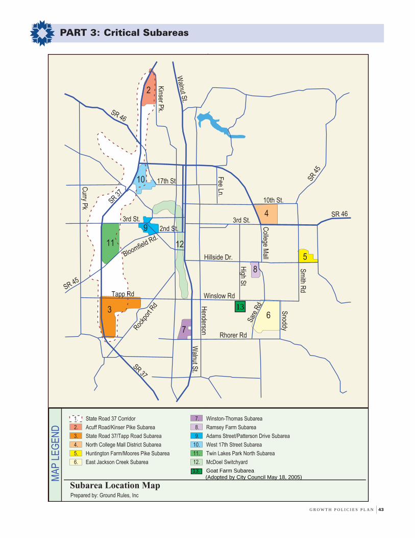
G R O W T H P O L I C I E S P L A N 43
PART 3: Critical Subareas
MA
P L
EG
EN
D
Prepared by: Ground Rules, Inc
Subarea Location Map
7. Winston-Thomas Subarea
8. Ramsey Farm Subarea
9. Adams Street/Patterson Drive Subarea
10. West 17th Street Subarea
11. Twin Lakes Park North Subarea
12. McDoel Switchyard
1. State Road 37 Corridor
2. Acuff Road/Kinser Pike Subarea
3. State Road 37/Tapp Road Subarea
4. North College Mall District Subarea
5. Huntington Farm/Moores Pike Subarea
6. East Jackson Creek Subarea
SR 37
Walnut S
t.
SR 45
SR 46
Hillside Dr.
Winslow Rd
Bloomfield Rd.
3rd St.
10th St.
SR 46
SR 4
5
2nd St.
SR 37
Kinser P
k.
Fee Ln.
Walnut S
t.
Rockp
ort R
d
Tapp Rd
Henderson
Curry P
k
Sar
e R
d
High S
t
Sm
ith Rd
Rhorer Rd
College M
all
Snoddy
3rd St.
17th St
2
6
7
8
9
10
11
5
4
3
12
13. Goat Farm Subarea (Adopted by City Council May 18, 2005)
13
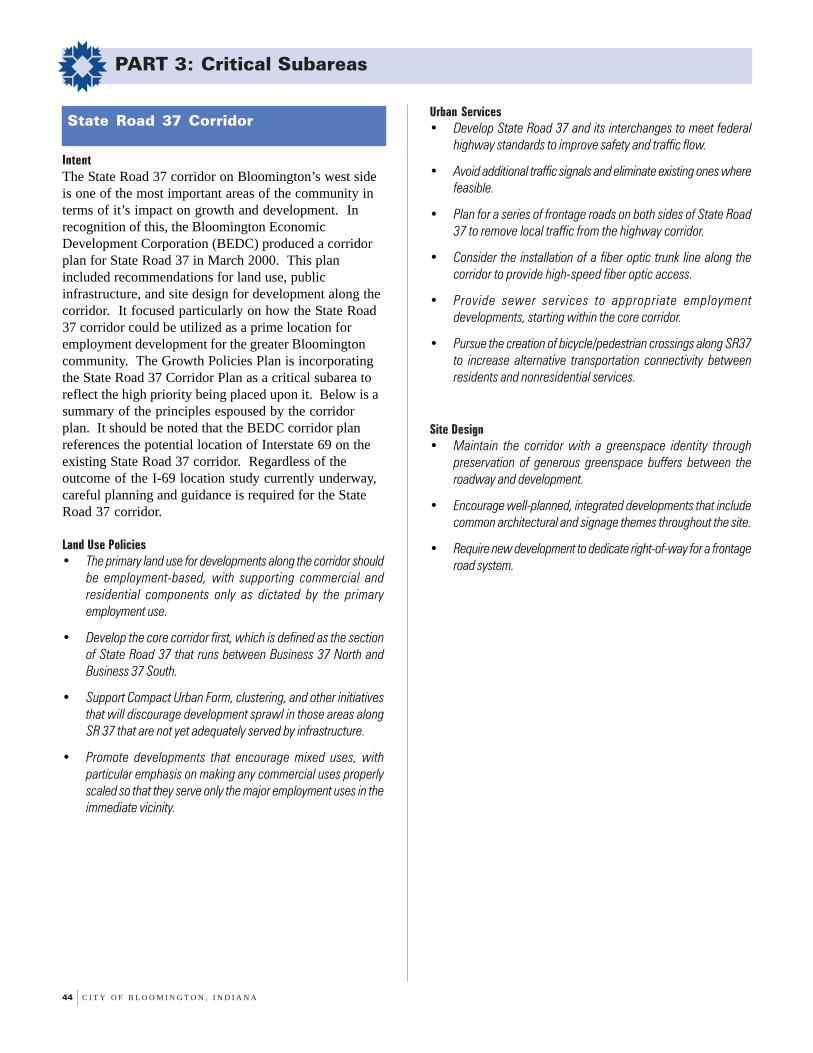
44 C I T Y O F B L O O M I N G T O N , I N D I A N A
PART 3: Critical Subareas
IntentThe State Road 37 corridor on Bloomington’s west sideis one of the most important areas of the community interms of it’s impact on growth and development. Inrecognition of this, the Bloomington EconomicDevelopment Corporation (BEDC) produced a corridorplan for State Road 37 in March 2000. This planincluded recommendations for land use, publicinfrastructure, and site design for development along thecorridor. It focused particularly on how the State Road37 corridor could be utilized as a prime location foremployment development for the greater Bloomingtoncommunity. The Growth Policies Plan is incorporatingthe State Road 37 Corridor Plan as a critical subarea toreflect the high priority being placed upon it. Below is asummary of the principles espoused by the corridorplan. It should be noted that the BEDC corridor planreferences the potential location of Interstate 69 on theexisting State Road 37 corridor. Regardless of theoutcome of the I-69 location study currently underway,careful planning and guidance is required for the StateRoad 37 corridor.
Land Use Policies• The primary land use for developments along the corridor should
be employment-based, with supporting commercial andresidential components only as dictated by the primaryemployment use.
• Develop the core corridor first, which is defined as the sectionof State Road 37 that runs between Business 37 North andBusiness 37 South.
• Support Compact Urban Form, clustering, and other initiativesthat will discourage development sprawl in those areas alongSR 37 that are not yet adequately served by infrastructure.
• Promote developments that encourage mixed uses, withparticular emphasis on making any commercial uses properlyscaled so that they serve only the major employment uses in theimmediate vicinity.
Urban Services• Develop State Road 37 and its interchanges to meet federal
highway standards to improve safety and traffic flow.
• Avoid additional traffic signals and eliminate existing ones wherefeasible.
• Plan for a series of frontage roads on both sides of State Road37 to remove local traffic from the highway corridor.
• Consider the installation of a fiber optic trunk line along thecorridor to provide high-speed fiber optic access.
• Provide sewer services to appropriate employmentdevelopments, starting within the core corridor.
• Pursue the creation of bicycle/pedestrian crossings along SR37to increase alternative transportation connectivity betweenresidents and nonresidential services.
Site Design• Maintain the corridor with a greenspace identity through
preservation of generous greenspace buffers between theroadway and development.
• Encourage well-planned, integrated developments that includecommon architectural and signage themes throughout the site.
• Require new development to dedicate right-of-way for a frontageroad system.
State Road 37 Corridor

G R O W T H P O L I C I E S P L A N 45
PART 3: Critical Subareas
OR
IEN
TA
TIO
N M
AP
MA
P L
EG
EN
D
Employment Center
Existing Roadway
New Roadway
Frontage Road
Preserve Buffer
New Overpass
New Interchange
Prepared by: Ground Rules, Inc.
State Road 37 Corridor
SR 37
Walnut S
t.
SR 45
SR 46
Hillside Dr.
Winslow Rd
Bloomfield Rd.
3rd St.
10th St.
SR 46
SR 4
5
2nd St.
SR 37
Kinser P
k.
Fee Ln.
Walnut S
t.
Roc
kpor
t Rd
Tapp Rd
Henderson
Curry P
k
Sar
e R
d
High S
t
Sm
ith Rd
Rhorer Rd
College M
all
Snoddy
3rd St.
17th St
Maple G
roveVernal Pike
Tapp Road
SR
37
& 4
5
3rd Street
Cur
ry P
ike
Bloomfield R
d.
Rockp
ort R
d.
New S.R. 46
Fullerton Pike

46 C I T Y O F B L O O M I N G T O N , I N D I A N A
PART 3: Critical Subareas
IntentThis site is bordered by Acuff Road, Kinser Pike, andState Road 37. The site is designated for Employment,as defined in the Land Use Categories section of thePlan. More specifically, this Subarea is intended todevelop as a planned center for corporate offices andlight manufacturing, with small scale site-serving retailand service uses also being allowed. As a gateway toBloomington, great care must be taken in site design.
Land Use Policies• Ensure that land for corporate office development is reserved.
• There is a need for retail and service uses in this Subarea (i.e.day care, office supplies, and restricted retail). However, theseuses should not create off-site traffic generation. The objectiveis provide service to on-site customers, not promote regionaldestination traffic.
Urban Services• The City should continue using public funding sources to provide
sanitary sewer, water, and fiber optic extensions into thisSubarea concurrent with development.
• In addition to internal pathway amenities, sidewalks should berequired along all new public streets and County roadways.
• Tax Increment Finance revenues from this Subarea should bedesignated to upgrade existing roadway conditions on AcuffRoad and Kinser Pike.
• If the State designates State Road 37 as a limited accesshighway, changes to intersections at Acuff Road and KinserPike will be a major issue. Viability of employment uses willrequire an interchange at one of these intersections. TheBloomington Metropolitan Planning Organization’s current LongRange Transportation Plan designates Kinser Pike as the mostdesirable location for a limited access interchange.
Site Design• The interface between existing residential areas along Kinser
Pike and future nonresidential uses should be an importantdesign consideration, especially in regards to the location ofloading docks, parking, and security lighting. Maintenance ofthe surrounding residential quality of life should be a keyconsideration in the site design of this business park.
• The routing of visitor and delivery traffic should be orientedaway from Kinser Pike and toward State Road 37.
• Site design should incorporate a coordinated pedestrian pathwaysystem, containing linkages with employee-oriented amenities(i.e. small parks, recreational space, etc.).
• Site development should incorporate common design themes;with coordinated site features, sign controls, and 360 degreebuilding profiles to insure an aesthetic appearance from StateRoad 37.
Acuff Road/Kinser Pike Subarea

G R O W T H P O L I C I E S P L A N 47
PART 3: Critical Subareas
SR
37
Acuff Road
Kin
ser
Pik
e
Prow Road Extension
Employment Center
Existing Roadway
New Roadway
Preserve Buffer
New Overpass
New Interchange
Prepared by: Ground Rules, Inc.
Acuff Road/Kinser Pike Subarea
SR 37
Walnut S
t.
SR 46
Hillside Dr.
Winslow Rd
Bloomfield Rd.
3rd St.
10th St.
SR 46
SR 4
5
2nd St.
SR 37
Kinser P
k.
Fee Ln.
Walnut S
t.
Roc
kpor
t Rd
Tapp Rd
Henderson
Curry P
k
Sar
e R
d
High S
t
Sm
ith Rd
Rhorer Rd
College M
all
Snoddy
3rd St.
17th St
SR 45
OR
IEN
TA
TIO
N M
AP
MA
P L
EG
EN
D
48 C I T Y O F B L O O M I N G T O N , I N D I A N A
PART 3: Critical Subareas
IntentThis site is located north of Fullerton Pike, east of StateRoad 37, south of Tapp Road, and runs east to theboundary of the Woolery Farm PUD. Vacant land in thisSubarea is designated for Employment, as defined in theLand Use Categories section of the Plan. This must beachieved through minimizing the impact of developmenton the high quality environs located throughout thisproperty. More specifically, the intent of the Subareashould be to foster development of medical andcorporate office land uses while insuring the preservationof environmentally valuable and sensitive lands.
Land Use Policies• Medical and corporate office land uses are recommended; with
light manufacturing and site-serving retail also being permitted.Medical offices are particularly desired east of the SouthernIndiana Medical Park, while corporate offices should beconsidered along the State Road 37 frontage near FullertonPike.
• An assisted care living facility has been approved on the FullertonPike site in the past. Such a facility could be considered in thefuture for this Subarea provided that it does not consumesignificant acreage which should be devoted to employmentuses.
Urban Services• Limited sanitary sewer and water capacity is available, which
dictates that development should be phased from Tapp Roadsouthward to Fullerton Pike. As a result, development of aportion of this subarea shall be governed under a master utilityplan which addresses future service for the entire subarea.
• Because roadway infrastructure is deficient in this Subarea,any request for development should include consideration ofTax Increment Financing. Improvements that should beconsidered include the continued widening of Tapp Road,improved vertical geometry on Fullerton Pike, intersectionimprovements at Fullerton/SR 37 and Fullerton and RockportRoad, and the eventual connection of Fullerton Pike and GordonPike.
• The Master Thoroughfare Plan designates a new north-southSecondary Collector through this Subarea to form a realignedfour-way intersection at Weimer Road. This roadway shouldnot negatively impact or intrude on high quality andenvironmentally sensitive areas on this property.
• If State Road 37 is designated a limited access highway, thenfurther planning should consider the closure of the Tapp Roadintersection with State Road 37, along with a full interchangedeveloping at the Fullerton Pike intersection.
Site Design• For property fronting State Road 37, site planning controls should
be emphasized, including a 360 degree building profile alongthe highway. The presence of parking lots should be limitedalong SR 37.
• Maintenance of the existing woodland buffer along sections ofState Road 37 is critical. The preferred width of this buffershould be at least 100 feet.
• Pedestrian connections should be emphasized betweendevelopments bordering either side of the Clear Creek floodplain.Additional integration of pedestrian connections with the ClearCreek Trail is a required site design element.
• Site design should take into account and reflect the sensitivenature of the Subarea, especially areas with heavy woodland,steep slopes, and karst. Conservation of these areas asgreenspace is a required feature, and can significantly enhancethe attractiveness of business park development.
State Road 37/Tapp Road Subarea
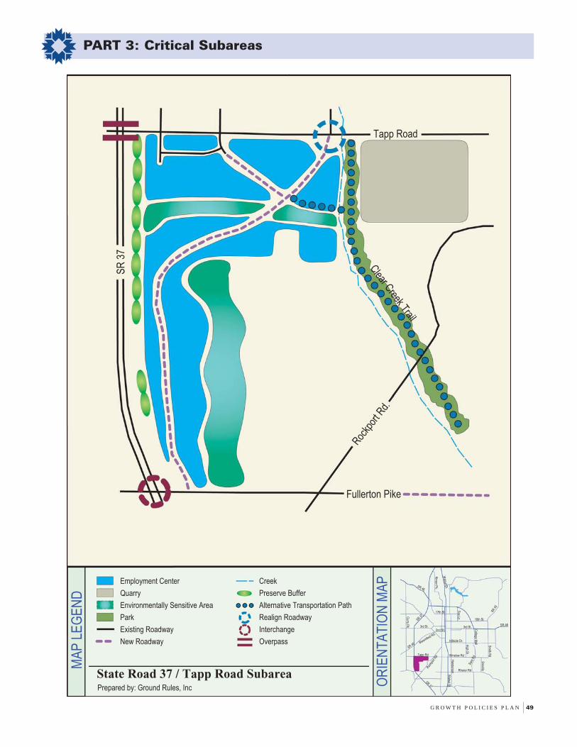
G R O W T H P O L I C I E S P L A N 49
PART 3: Critical Subareas
SR
37
Rockp
ort R
d.
Fullerton Pike
Tapp Road
Clear C
reek Trail
Creek
Preserve Buffer
Alternative Transportation Path
Realign Roadway
Interchange
Overpass
Employment Center
Quarry
Environmentally Sensitive Area
Park
Existing Roadway
New Roadway
OR
IEN
TA
TIO
N M
AP
MA
P L
EG
EN
D
Prepared by: Ground Rules, Inc
State Road 37 / Tapp Road Subarea
SR 37
Walnut S
t.
SR 45
SR 46
Hillside Dr.Bloomfield Rd.
3rd St.
10th St.
SR 46
SR 4
5
2nd St.
SR 37
Kinser P
k.
Fee Ln.
Walnut S
t.
Roc
kpor
t Rd
Tapp Rd
Henderson
Curry P
k
Sar
e R
d
High S
t
Sm
ith Rd
Rhorer Rd
College M
all
Snoddy
3rd St.
17th St
Winslow Rd

50 C I T Y O F B L O O M I N G T O N , I N D I A N A
PART 3: Critical Subareas
IntentThis site is located north of 3rd Street, east of the StateRoad 45/46 Bypass, south of 10th Street/State Road 45,and west of the Bell Trace Retirement Community/ParkRidge Neighborhood. Although the Subarea has multipleland use designations, the majority of the property isbeing utilized for commercial or multifamilydevelopment. Several new prospects need to beintegrated into future development of this Subarea.These include the Daisy Garton site (at 10th Street andPete Ellis Drive), the vacant site north of the Barnes &Noble development, and the area located north of thenew Marsh grocery store. The intent of this Subarea isto allow for intensification, but only with improvementsto the overall quality of site amenities and no negativeimpacts to the Lake Griffy Watershed.
Land Use Policies• The vacant Garton site is designated “Urban Residential”. This
designation recommends residential land usage, with theintegration of mixed uses where supported by adjacent landuse patterns. Preservation of the existing residential and farmstructures should be a critical design element in future sitedevelopment.
• The vacant site east of St. Mark’s United Methodist Church isdesignated Community Activity Center, which recommends amixture of community-scaled retail uses, with ancillary officesand residential activities. This site, along with the church site,should be considered for eventual intensification of use basedon the implementation of roadway and intersectionimprovements to the SR 45/46 Bypass and East 3rd Street.
• The remaining unbuilt portion of the PUD north of the newMarsh is suitable for a higher intensity use, such as professionaloffices or higher density multifamily.
• All development within the Lake Watershed Protection OverlayArea shall provide a Watershed Mitigation Plan to ensuredevelopment has no short or long-term negative impacts on thewatershed.
Urban Services• Traffic calming techniques should be implemented in order to
slow east and west-bound traffic on Longview Avenue.
• The City and the State of Indiana shall coordinate signalizedupgrades at the 3rd Street intersections with Pete Ellis Driveand Clarizz Boulevard, as well as a signal upgrade at the PeteEllis/10th Street intersection. Development in this Subarea whichoccurs prior to these upgrades shall require close scrutinization.
• The existing sidepath along Clarizz Boulevard, south of East 3rd
Street, shall be extended through this Subarea and connectedwith the railroad pathway south of 10th Street.
• The City shall coordinate with the State of Indiana to ensurethat the future East 10th Street widening project is designed toincorporate multi-use pathway construction as well as transitpull-offs and shelters.
Site Design• Strong access control for major thoroughfares bordering this
Subarea is critical.
• Upgrades in existing commercial sites are strongly encouraged.Such upgrades should include changes in building/parkingorientation, signage reductions, access management, andadditional landscaping.
• As site development occurs, pedestrian/bicycle improvementsshould be made to ensure convenient access to the proposednew pedestrian/bicycle underpass at the 7th Street/Bypassintersection, as well as the existing trail running along therailroad tracks.
North College Mall District Subarea

G R O W T H P O L I C I E S P L A N 51
PART 3: Critical Subareas
OR
IEN
TA
TIO
N M
AP
MA
P L
EG
EN
D
Urban Residential
Institutional
Community Activity Center
Homestead Preservation
Regional Activity Center
Access Control
Existing Roadway
New Roadway
Alternative Transportation Path
Alternative Trans. Under/Overpass
New Traffic Signal
Potential Removal of Traffic Signal
Railroad
Prepared by: Ground Rules, Inc.
North College Mall District Subarea
SR 37
Walnut S
t.
SR 45
SR 46
Hillside Dr.
Winslow Rd
Bloomfield Rd.
3rd St.
10th St.
SR 46
SR 4
5
2nd St.
SR 37
Kinser P
k.
Fee Ln.
Walnut S
t.
Roc
kpor
t Rd
Tapp Rd
Henderson
Curry P
k
Sar
e R
d
High S
t
Sm
ith Rd
Rhorer Rd
College M
all
Snoddy
3rd St.
17th St
SR 45
SR
46
3rd Street
Pet
e E
llis
Dr.

52 C I T Y O F B L O O M I N G T O N , I N D I A N A
PART 3: Critical Subareas
IntentThis site is located north of Moores Pike, east of SmithRoad, West of State Road 446, and bounded on the northby the Gentry Honours PUD, Gentry Estates, and theHearthstone residential development. The Subarea isdesignated as Urban Residential in the Land UseCategories Section of the Plan. However, alternative landuses such as a major City park and a NeighborhoodActivity Center should also be considered.
Land Use Policies• Development of this Subarea is encouraged to incorporate a
mixture of residential uses and densities.
• Development of this Subarea should be guided according to amaster development plan, not as a piecemeal project.
• The possible use of the portion of the property as a park facilityor Neighborhood Activity Center should not be overlooked.Currently, there are no active park facilities east of College MallRoad, between 3rd Street and Moores Pike.
Urban Services• Smith Road and Moores Pike will both need to be upgraded as
development occurs in this Subarea.
• Full signalization of the intersection of Smith Road and MooresPike should be anticipated, as well as the Moores Pikeintersection with State Road 446.
• Locations for transit facilities should be provided with thedevelopment of this Subarea in anticipation of future transitservice.
Site Design• Design of the internal road network should employ a grid pattern,
with connections to Gentry Honours, Gentry Estates andHearthstone being enabled. Access should be limited tomaximize safety along Smith Road and Moores Pike.
• Tree preservation along the creek area in the northern portion ofthe Subarea must be included in site development design.
• Density and potential uses must be located to mitigate potentialimpacts on lower density single family residential and pairedpatio homes to the north and east.
Huntington Farms/Moores Pike Subarea
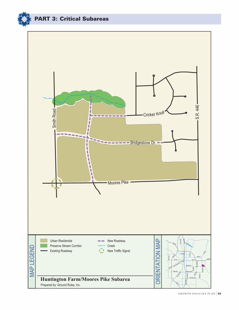
G R O W T H P O L I C I E S P L A N 53
PART 3: Critical Subareas
OR
IEN
TA
TIO
N M
AP
MA
P L
EG
EN
D
Urban Residential
Preserve Stream Corridor
Existing Roadway
New Roadway
Creek
New Traffic Signal
Prepared by: Ground Rules, Inc.
Huntington Farm/Moores Pike Subarea
SR 37
Walnut S
t.
SR 45
SR 46
Hillside Dr.
Winslow Rd
Bloomfield Rd.
3rd St.
10th St.
SR 46
SR 4
5
2nd St.
SR 37
Kinser P
k.
Fee Ln.
Walnut S
t.
Roc
kpor
t Rd
Tapp Rd
Henderson
Curry P
k
Sar
e R
d
High S
t
Sm
ith Rd
Rhorer Rd
College M
all
Snoddy
3rd St.
17th St
Moores Pike
Sm
ith R
oad
Cricket Knoll
Bridgestone Dr.
S.R
. 446

54 C I T Y O F B L O O M I N G T O N , I N D I A N A
PART 3: Critical Subareas
IntentThis site is located south of Rogers Road, west ofSnoddy Road, east of the Canada Farm PUD andSherwood Oaks Christian Church, and runs south to theCity’s planning jurisdiction boundary. This area isdivided by the floodway of the East Fork of JacksonCreek. This Subarea is intended to provide additionalresidential development opportunities at mixed urbandensities, while defining the southeastern urban edge ofBloomington.
Land Use Policies• Urban scale densities are appropriate west of Jackson Creek,
with a mix of residential types encouraged to complementexisting development patterns.
• Reduced densities (less than 1 unit per acre) are appropriatefor the area east of Jackson Creek.
• Development must be sensitive to the environmental constraintspresent in the area. As well, the preservation of Jackson Creek’sfloodplain should be incorporated into plans using conservationeasements and greenways.
Urban Services• The intersection of Rogers and Sare Road has poor geometry
for a 4-way intersection, necessitating the existing four-waystop configuration. This intersection will require fullsignalization as development progresses south of Rogers Road.
• The poor sight distance at the Rogers Road/Snoddy Roadintersection must be improved as additional traffic is generatedfrom this Subarea.
• Road connections across the Jackson Creek floodplain are notrecommended due to topographic and other environmentalconstraints. Options for additional pedestrian connectionsshould be explored with each development east of JacksonCreek.
Site Design• A goal for this Subarea is to utilize innovative residential design
to minimize site disturbance and protect scenic areas.Clustering and smaller lot sizes should be considered as analternative to large-lot subdivision.
• Additional recommended elements of site design should includepedestrian facilities, such as sidewalks or asphalt pathways, toconnect with Schmaltz Farm Park as well as the futurecommercial/office development within the Canada Farm PUD.A major sidepath facility should be installed along the southside of Rogers Road connecting Schmaltz Farm Park with theSare Road pathway accessing the Canada Farm PUD.
East Jackson Creek Subarea

G R O W T H P O L I C I E S P L A N 55
PART 3: Critical Subareas
OR
IEN
TA
TIO
N M
AP
MA
P L
EG
EN
D
Conservation Residential
Urban Residential
Preserve Stream Corridor
Existing Roadway
New Roadway
Creek
Alternative Transportation Path
Improve Intersection
Prepared by: Ground Rules, Inc.
East Jackson Creek Subarea
SR 37
Walnut S
t.
SR 45
SR 46
Hillside Dr.
Winslow Rd
Bloomfield Rd.
3rd St.
10th St.
SR 46
SR 4
5
2nd St.
SR 37
Kinser P
k.
Fee Ln.
Walnut S
t.
Roc
kpor
t Rd
Tapp Rd
Henderson
Curry P
k
Sar
e R
d
High S
t
Sm
ith Rd
Rhorer Rd
College M
all
Snoddy
3rd St.
17th St
Sar
e R
oad
Rogers Rd.
Sno
ddy
Rd
Rhorer Rd.

56 C I T Y O F B L O O M I N G T O N , I N D I A N A
PART 3: Critical Subareas
IntentThis site is located west of Old State Road 37 and northof Gordon Pike, and includes a portion of the ClearCreek floodway on its western edge. This is the City’sformer wastewater treatment plant, which has recentlyreceived clearance as a cleaned PCB site by EPA. ThisSubarea is designated for Employment, as defined in theLand Use Categories section of the Plan.
Land Use Policies• Encourage the reuse of this site for employment uses, and related
institutional and commercial service uses.
• Placement of uses on site should be integrated with existingcommercial, industrial, and institutional uses along Old StateRoad 37 as well as residential uses west of Clear Creek andsouth of Gordon Pike.
Urban Services• Gordon Pike is adequate for grade and width, but lacks other
urban facility characteristics (closed stormwater facilities, curbs/gutters, sidewalks, street lights). These facilities should beinstalled concurrent with site redevelopment.
• Recent development approvals adjacent to this site as well asthe potential future development within this site will necessitatethe consideration of an upgrade to the Old State Road 37corridor.
Site Design• During site redevelopment, incorporate pedestrian connectivity
to the City’s Victor Oolitic Trail running north-south along thewest side of the Subarea.
• Sidewalk upgrades along Gordon Pike and Old State Road 37are needed with redevelopment of this Subarea.
• Access control to Old State Road 37 and Gordon Pike isrecommended. This can be accomplished by the constructionof a single internal street providing access to the entiredevelopment.
• Site design should be coordinated with City of BloomingtonUtilities and the EPA in order to ensure compliance withenvironmental clean-up regulations.
Winston-Thomas Subarea
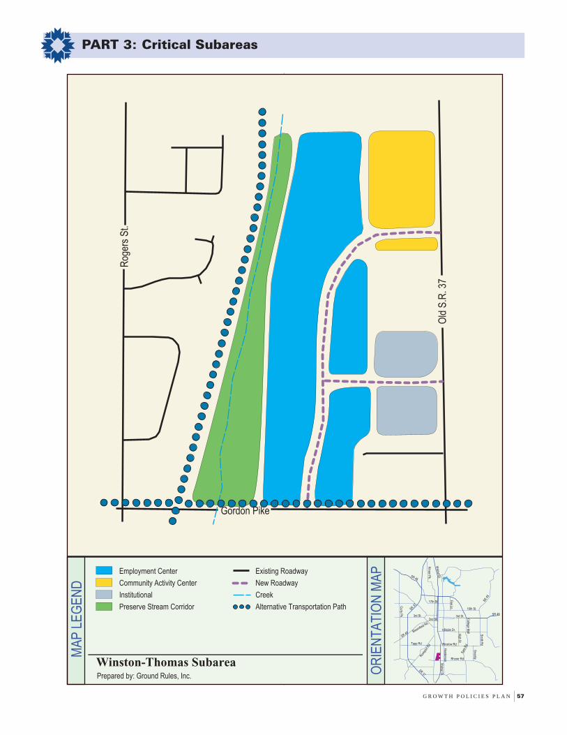
G R O W T H P O L I C I E S P L A N 57
PART 3: Critical Subareas
OR
IEN
TA
TIO
N M
AP
MA
P L
EG
EN
D
Employment Center
Community Activity Center
Institutional
Preserve Stream Corridor
Existing Roadway
New Roadway
Creek
Alternative Transportation Path
Prepared by: Ground Rules, Inc.
Winston-Thomas Subarea
Walnut S
t.
SR 46
Hillside Dr.Bloomfield Rd.
3rd St.
10th St.
SR 46
SR 4
5
2nd St.
Kinser P
k.
Fee Ln.
Tapp Rd
Henderson
Curry P
k
High S
t
Sm
ith Rd
Rhorer Rd
College M
all
Snoddy
3rd St.
SR 45
Winslow Rd
Walnut S
t.
SR 37
SR 37
Roc
kpor
t Rd
Sar
e R
d
17th St
Rog
ers
St.
Old
S.R
. 37
Gordon Pike

58 C I T Y O F B L O O M I N G T O N , I N D I A N A
PART 3: Critical Subareas
IntentThis site is located south of Moores Pike, west of SareRoad, and east and north of the Sycamore Knollsneighborhood. The site is split by the floodway for theWest Branch of Jackson Creek. The Ramsey Farmpresents an opportunity for high-quality, infill housingaccompanied by small-scale commercial uses.
Land Use Policies• This Subarea is designated “Urban Residential”, which
encourages the development of mixed residential housing aturban densities.
• The expansion of Southeast Park on the northwest portion ofthe site is highly recommended. The use of conservationeasements and greenways should also be used to preserve theWest Branch of Jackson Creek’s floodplain and environmentallysensitive areas on this site.
• Orientation of uses should place potential nonresidential usescloser to the northeastern portion of the site, limit the scale ofnonresidential uses, and provide for a tight design standard fornew nonresidential construction in keeping with traditionalneighborhood concepts.
Urban Services• A pathway facility along the floodway in the middle of the site is
recommended as an additional cross connection from SareRoad to Southeast Park and as an additional linkage to a plannedpath facility in the Jackson Creek floodway.
• Because development of this Subarea could add significantresidential units to the southeast side of Bloomington,coordination with the Monroe County Community SchoolCorporation is necessary to insure the availability of adequateschool facilities.
• Stormwater drainage issues are a significant concern givenpast downstream flooding problems along the West Branch ofJackson Creek. Development of this Subarea should incorporatevery stringent stormwater detention standards.
• The City’s Long Range Transportation Plan recommendsimprovements to both Moores Pike and Sare Road within thenext 20 years. Sare Road improvements near the Moores Pikeintersection are scheduled to occur within two years.
Site Design• In order to assure integrated site design, this Subarea should
be developed under a master development plan.
• Road connections to Queens Way and Rock Creek Drive shouldbe a required design element of Subarea development.
• Access to Moores Pike is a critical site design issue due tosight distance constraints, especially at coordinated pointsacross from Valley Forge Drive and Winfield Road.
• Design at stubbed street locations should feature a narrowerstreet profile, on-street parking and calming measures (suchas neck-downs) to discourage cut-through traffic.
• Preservation of natural features on site is strongly encouraged.This includes stream buffer protection in the interior of the site,tree preservation at the south end of the Subarea, and steepslope protection on the east side of the site.
• The character of the site along Moores Pike is enhanced by anexisting tree row of ornamental tree species; these trees shouldbe preserved during site development.
Ramsey Farm Subarea
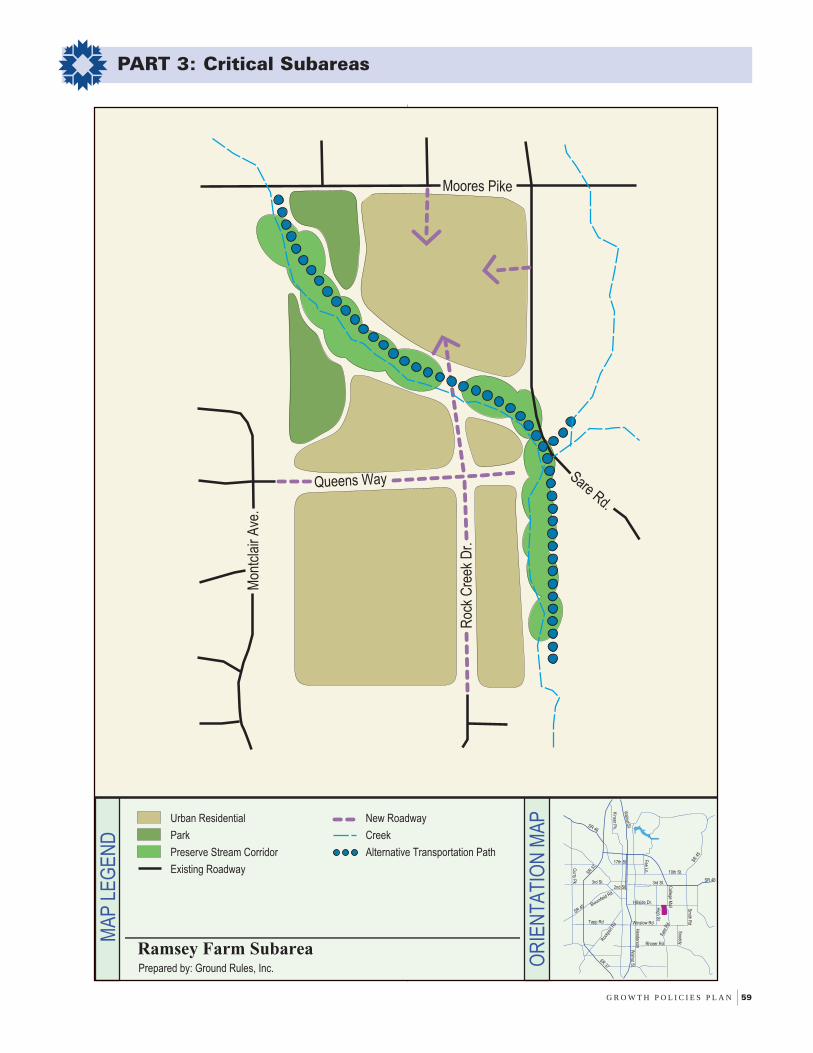
G R O W T H P O L I C I E S P L A N 59
PART 3: Critical Subareas
OR
IEN
TA
TIO
N M
AP
MA
P L
EG
EN
D
Urban Residential
Park
Preserve Stream Corridor
Existing Roadway
New Roadway
Creek
Alternative Transportation Path
Prepared by: Ground Rules, Inc.
Ramsey Farm Subarea
SR 37
Walnut S
t.
SR 45
SR 46
Hillside Dr.
Winslow Rd
Bloomfield Rd.
3rd St.
10th St.
SR 46
SR 4
5
2nd St.
SR 37
Kinser P
k.
Fee Ln.
Walnut S
t.
Roc
kpor
t Rd
Tapp Rd
Henderson
Curry P
k
Sar
e R
d
High S
t
Sm
ith Rd
Rhorer Rd
College M
all
Snoddy
3rd St.
17th St
Queens Way
Mon
tcla
ir A
ve.
Sare Rd.
Moores Pike
Roc
k C
reek
Dr.

60 C I T Y O F B L O O M I N G T O N , I N D I A N A
PART 3: Critical Subareas
IntentThis Subarea is a conglomeration of existingunderdeveloped or underutilized properties that arelargely zoned commercial. It is located west of WalkerStreet, south and west of Rose Hill Cemetery, and runsgenerally west to the Landmark PUD and south toBloomfield Road. The area is prime for redevelopmentwith the realignment of the 3rd/5th/Adams corridor, thecompletion of Patterson Drive, and the future wideningof West 3rd Street. The balance of the Subarea isdesignated Community Activity Center. The goal of thisSubarea is to upgrade site planning quality throughdevelopment and redevelopment, while insuring a densemixture of service uses.
Land Use Policies• Development should insure that commercial services are
conveniently located to serve employment uses in the Subarea,as well as designed to allow for non-vehicular access fromnearby residential areas.
• Road upgrades will spark investment toward commercial retailfacilities. Balancing these market demands with a need tofurther develop other types of nonresidential uses (employment-based) will be critical.
Urban Services• Bloomfield Road is slated for widening within the next 5-7 years.
Prior to this widening a subarea plan should be developedwhich addresses ideal roadway cross-sections, accessmanagement, and desired land uses.
• Development along the east side of Patterson Drive should beaugmented by the construction of new sidewalks.
• New commercial and employment development in this Subareashould be accommodated with new transit stop facilities.
Site Design• Special design attention shall be paid to three key redevelopment
sites within this Subarea. These sites are the automobile storageyard at Adams and Kirkwood, the Rogers Building Suppliesproperty, and the property located along the east side of PattersonDrive, between West 3rd Street and Bloomfield Road.
• Access to arterial roadways (3rd Street, Patterson Drive,Bloomfield Road) must be tightly controlled as part of thedevelopment review process.
• Redevelopment and intensification should be accompanied byincreased landscaping, greenspace opportunities, and building-forward design.
• The floodway of the West Branch of Clear Creek should berehabilitated to improve its environmental quality. Opportunitiesfor additional stormwater detention as well as pedestrianconnectivity between Bloomfield Road and West 3rd Streetshould also be considered for this area.
Adams Street/Patterson Drive Subarea

G R O W T H P O L I C I E S P L A N 61
PART 3: Critical Subareas
OR
IEN
TA
TIO
N M
AP
MA
P L
EG
EN
D
Urban Residential
Community Activity Center
Employment Center
Preserve Creek Corridor
Institutional
Existing Roadway
Creek
Prepared by: Ground Rules, Inc.
Adams Street/Patterson Drive Subarea
SR 37
Walnut S
t.
SR 45
SR 46
Hillside Dr.
Winslow Rd
Bloomfield Rd.
3rd St.
10th St.
SR 46
SR 4
5
2nd St.
SR 37
Kinser P
k.
Fee Ln.
Walnut S
t.
Roc
kpor
t Rd
Tapp Rd
Henderson
Curry P
k
Sar
e R
d
High S
t
Sm
ith Rd
Rhorer Rd
College M
all
Snoddy
3rd St.
17th St
Bloomfield Rd.
Patterson Dr.Kirkwood Ave.
W. 3rd St.
S. A
dam
s S
t
S. W
alke
r S
t.
S. A
dam
s S
t
W. 3rd St.
Landmark Ave.
62 C I T Y O F B L O O M I N G T O N , I N D I A N A
PART 3: Critical Subareas
IntentThis Subarea is generally located east of State Road 37,south of the State Road 45/46 Bypass, West of ArlingtonRoad, and north of the Crestmont/Bloomington HousingAuthority neighborhood. The Subarea is largely anamalgamation of platted, narrow residential lots mixedwith larger undeveloped tracts of land. The east portion,at the intersection of 17th Street and Monroe Street, is acollection of small industrial activities. The corner northand west of the Arlington/17th/Monroe merger (the so-called K-intersection) is designated for a futurecommunity activity center. This area could provide anopportunity for medium to high-density housing orservice-oriented uses. The intent of this Subarea is toencourage the development of aggregated parcels forservice, residential, and employment uses.
Land Use Policies• The majority of the West 17th Street subarea is designated Urban
Residential, which is intended for a pattern of mixed residentialuses at urban densities. This housing should be incorporatedas a transitional use between the western tracts designated forEmployment and lower density single family housing along 17th
Street.
• The property located along State Road 37 should be reservedfor employment land uses (i.e. light manufacturing or offices).
Urban Services• Transit service expansion north of the Housing Authority site is
necessary to augment future residential development at urbandevelopment densities.
• Monroe Street is adequate for width, but lacks urban facilitiesin most places and presents grade problems for future uses.Curb and sidewalk upgrades should be constructed along thelength of this street.
• 17th Street is a narrow, hilly roadway that lacks most urbanfacilities, especially closed stormwater facilities, curbs/gutters,and sidewalks. Redevelopment and development efforts in thearea should be linked to physical improvements to this street,including curbs, sidewalks and street trees.
• Further development or redevelopment of the subarea willrequire the upgrade and realignment of the Arlington Road/17th
Street/Monroe Street K-intersection. In addition, the 17th andLindbergh intersection must also be made safer.
• Development of the properties north of Arlington ParkApartments and Superior Lumber should be accompanied by afrontage road connection from 17th Street to State Road 46.
Site Design• Natural feature preservation should be sought for quality tree
stands in the Subarea, and project layouts should respect theexisting topography as much as possible.
• The emphasis of new development should be on creatingaffordable, mixed use housing.
• This Subarea contains existing vegetation adjacent to StateRoad 37. Any development proposal must include preservationof this vegetation.
• Attention to site design, especially a 360 degree building profileadjacent to State Road 37 and limited parking lot exposure tothe highway, should be a feature of future employmentdevelopment.
West 17th Street Subarea
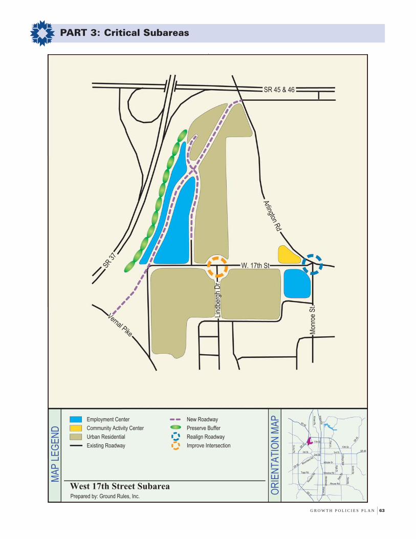
G R O W T H P O L I C I E S P L A N 63
PART 3: Critical Subareas
W. 17th St
Vernal Pike
SR 3
7
Arlington R
d
Lind
berg
h D
r.
Mon
roe
St.
SR 45 & 46
Employment Center
Community Activity Center
Urban Residential
Existing Roadway
New Roadway
Preserve Buffer
Realign Roadway
Improve Intersection
Prepared by: Ground Rules, Inc.
West 17th Street Subarea
OR
IEN
TA
TIO
N M
AP
MA
P L
EG
EN
D
SR 37
Walnut S
t.
SR 45
SR 46
Hillside Dr.
Winslow Rd
Bloomfield Rd.
3rd St.
10th St.
SR 46
SR 4
5
2nd St.
SR 37
Kinser P
k.
Fee Ln.
Walnut S
t.
Roc
kpor
t Rd
Tapp Rd
Curry P
k
Sar
e R
d
High S
t
Sm
ith Rd
Rhorer Rd
College M
all
Snoddy
3rd St.
17th St
Henderson

64 C I T Y O F B L O O M I N G T O N , I N D I A N A
PART 3: Critical Subareas
IntentThis Subarea is located east of State Road 37, north ofBloomfield Road, west of Shady Acres and Cory LaneEstates, and south of 3rd Street. The area encompassesthe Bradford Ridge and Basswood apartment complexes,the Twin Lakes Sports Park, Kerasotes Theater, and thesouth side of the 3rd Street commercial strip. Vacantland within this Subarea is designated “UrbanResidential”. The intent of this section is to fosterfurther residential development without compromisingenvironmental preservation goals.
Land Use Policies• Patterns of land use in the southern extent of the Subarea dictate
multifamily development consistent with densities already inplace. This includes both the vacant, developable land locatedwithin the Brown property as well as the Ooley site.Nonresidential uses could be considered on the Ooley propertyin consideration of the cost of a roadway connection to West 3rd
Street.
• Opportunities to preserve sensitive areas and open space toreduce habitat fragmentation should be a requirement fordevelopment in this area. In addition, the expansion of TwinLakes Park’s overall acreage should be sought through additionalland dedications during development review.
• Aggregation of commercial land uses along the soon-to-bewidened West 3rd Street is necessary for improved traffic safetyas well as improved aesthetics along the corridor.
• The small acreage north of Bloomfield Road and south of theBasswood Apartments complex should be considered for aneighborhood commercial land use.
Urban Services• The Master Thoroughfare Plan currently depicts Weimer Road
being extended from Bloomfield Road to 3rd Street as part of aCity frontage road system. Feasibility of this extension is hinderedby several factors: environmental sensitivity of the subarea,potential negative impacts to operations at the Twin Lakes SportsPark, need for a future railroad crossing, and the presence ofBasswood Drive as a possible frontage road alternative. All ofthese feasibility issues must be closely examined prior to anyconsideration of this roadway extention.
• Transit service expansion is necessary to allow further residentialintensification of this Subarea.
• Basswood Drive is stubbed into the Brown property and isproposed for extention into the Ooley site. This roadway couldeither be connected to a possible Weimer Road extension, orextended all the way to 3rd Street if the Weimer Road extensionis determined to be infeasible. Basswood Drive will requiresignalization concurrent with the development of the Brownproperty.
• Ensure road connectivity east from the Ooley site to Cory Lane,as additional access to and from Subarea.
• Given the drainage problems that have occurred in the LowerTwin Lakes region, development of this Subarea shouldincorporate very stringent stormwater detention standards.
Site Design• Topography of the area, including sinkholes and steeply sloped
terrain, will limit development intensity and confine developmentto unchallenged areas.
• Tree preservation should be key design consideration onproperties adjacent to State Road 37 and adjacent to TwinLakes Park.
• Pedestrian and bicycle connectivity from vacant developmenttracts to Twin Lakes Park is a key site planning consideration.
• Development along the West 3rd Street area should have limitedaccess to West 3rd Street, reduced signage standards, andincreased attention paid to front yard landscaping.
Twin Lakes Park North Subarea
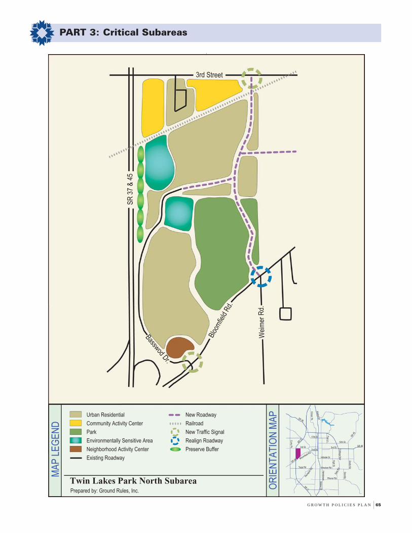
G R O W T H P O L I C I E S P L A N 65
PART 3: Critical Subareas
3rd Street
SR
37
& 4
5
Blo
omfie
ld R
d.
Wei
mer
Rd.
Basswod Dr.
OR
IEN
TA
TIO
N M
AP
MA
P L
EG
EN
D
Urban Residential
Community Activity Center
Park
Environmentally Sensitive Area
Neighborhood Activity Center
Existing Roadway
New Roadway
Railroad
New Traffic Signal
Realign Roadway
Preserve Buffer
Prepared by: Ground Rules, Inc.
Twin Lakes Park North Subarea
SR 37
Walnut S
t.
SR 45
SR 46
Hillside Dr.
Winslow Rd
Bloomfield Rd.
3rd St.
10th St.
SR 46
SR 4
5
2nd St.
SR 37
Kinser P
k.
Fee Ln.
Walnut S
t.
Roc
kpor
t Rd
Tapp Rd
Henderson
Curry P
k
Sar
e R
d
High S
t
Sm
ith Rd
Rhorer Rd
College M
all
Snoddy
3rd St.
17th St

66 C I T Y O F B L O O M I N G T O N , I N D I A N A
PART 3: Critical Subareas
IntentAn on-going venture between public and private entitiesmay lead to the potential relocation of the McDoelSwitchyard to an area west of State Road 37. With thatin mind, a unique opportunity has may arise to redevelopa corridor that has been operated by the CSXTransportation company. This area extendsapproximately from Country Club Drive to Adams Streetalong the railroad line, including the McDoel Switchyard.Benefits related to redevelopment of this rail corridorinclude reduced traffic disruptions downtown, improvedenvironmental quality, and enhanced alternativetransportation opportunities.
Land Use Policies• Redevelopment of the McDoel Switchyard and rail corridor
should be focused towards creating a high quality urbangreenway.
• Remediation of the corridor must take place to ensure the cleanup of any contamination that may have occurred in the area byprevious land uses and activities.
• Promote mixed use development adjacent to the corridor thatencourages retail services, new housing opportunities, andrecreational amenities.
• In order to beautify the trailway, explore redevelopmentopportunities of industrial sites along the Morton Street corridor.
• Prior to future development, require a Watershed ProtectionPlan for the Switchyard area due to its location in a floodplainand presence of numerous wetland features.
Urban Services• Provide safety improvements to road crossings that allow for
bicycle and pedestrian accessibility.
• A connection of Hillside Drive between Walnut and RogersStreet should be constructed to allow for better east-westconnectivity through the subarea.
Site Design• Provide bicycle and pedestrian linkages from this future
greenway to key nearby destinations. For Example: 9th StreetPark, the Showers Building, the Victor/Oolitic Trail, and theBroadview and McDoel Gardens neighborhoods.
• Ensure that new development and redevelopment within thissubarea has appropriate orientation of uses and buildings tothe future greenway area.
• Explore the opportunity of facade improvement grants toencourage renovation of existing buildings.
McDoel Switchyard Subarea

G R O W T H P O L I C I E S P L A N 67
PART 3: Critical Subareas
OR
IEN
TA
TIO
N M
AP
11th Street
Rockp
ort R
d.
Kirkwood Ave.
S. Patterson Dr.Ada
ms
St.
S. W
alnu
t St.
Col
lege
Ave
.
Grimes Ln.
Rog
ers
St.
Country Club Dr.
S. W
alnut St.
W. Allen St.
1st Street
2nd Street
Hillside Rd
Employment Center
Community Activity Center
Downtown Commercial
Urban Residential
Institutional
Park
Key Redevelopment Area
Existing Roadway
New Roadway
Preserve Buffer
Alternative Transportation Path
Alternative Trans. Under/Overpass
Trailhead
Railroad
Prepared by: Ground Rules, Inc.
McDoel Switchyard Subarea
MA
P L
EG
EN
D
SR 37
Walnut S
t.
SR 45
SR 46
Hillside Dr.
Winslow Rd
Bloomfield Rd.
3rd St.
10th St.
SR 46
SR 4
5
2nd St.
SR 37
Kinser P
k.
Fee Ln.
Walnut S
t.
Roc
kpor
t Rd
Tapp Rd
Henderson
Curry P
k
Sar
e R
d
High S
t
Sm
ith Rd
Rhorer Rd
College M
all
Snoddy
3rd St.
17th St
Goat Farm SubareaIntentThis site is located south of Winslow Road, bordered onthe west by the Bentley Court and Sherwood Oakssubdivisions, and on the east by Jackson Creek and TheStands subdivision. This is a unique parcel ofgreenspace, which is characterized by several importanttraits including: environmentally sensitive areas, rural-like qualities in an urban context, and opportunities forinnovative public and private development. The Subareashould foster environmental preservation, ensureneighborhood compatibility and showcase high-qualityresidential development, without compromising thesensitive and unique traits of this site.
Land Use Policies
• The use of conservation easements and public land dedicationis strongly recommended to protect existing wildlife habitatsand environmentally sensitive features such as the JacksonCreek floodplain and its associated riparian buffer areas.
• The central location of the Subarea and its close proximity toChilds Elementary, Jackson Creek Middle School, SherwoodOaks Park and Olcott Park, make this site an important linkagebetween nearby public facilities. As a result, public accessand use are anticipated for floodplain portions of this site.
• Urban Residential densities consistent with existing zoningare appropriate for the non-floodplain portions of the Subarea.Density calculations should be based on areas locatedexclusively outside the Floodplain Study Area.
Urban Services
• Land dedication along Jackson Creek is strongly recommendedto enable future construction of a multi-use trail facility. Thissite provides a pedestrian and bicyclist linkage betweensurrounding neighborhoods, schools and parks as outlined inthe Jackson Creek Trail Master Plan. The Jackson CreekTrail corridor is an integral part of the Alternative Transportationand Greenways System Plan and as such, this connectionthrough the Goat Farm Subarea is critical.
• Additional connector paths to the multi-use trail and SherwoodOaks Park from any future residential uses should beconsidered in the development approval process.
• Stormwater drainage issues are a significant concern giventhe present flooding conditions along Jackson Creek.Development of this Subarea should incorporate stringentstormwater requirements and water quality standards toaccommodate on-site and off-site water flows from the northand west.
68 C I T Y O F B L O O M I N G T O N , I N D I A N A
Goat Farm Subarea
PART 3: Critical Subareas
Site Design
• Installation of the multi-use trail and connector paths shouldavoid tree loss. Disturbance to the riparian buffer andenvironmentally sensitive areas adjacent to Jackson Creekshould also be avoided. Land dedication for the multiuse trailshould be sufficient to prevent degradation of the function ofthe riparian buffer.
• Prior to development activity, floodplain modeling should beperformed by a qualified environmental consultant to ensurethat the site plan adequately protects the Jackson Creekfloodplain area.
• Access to the Goat Farm Subarea from the north should belimited to the existing street access at the High Street andRogers/ Winslow Road roundabout.
• Extensive landscaping buffers shall be utilized to minimizepotential impacts between existing and proposed residentialuses.

G R O W T H P O L I C I E S P L A N 69
PART 3: Critical Subareas
Adopted May 18, 2005

FOREWORDpage i
PART 1:Policy Essence
page 1
PART 2:The Geography of
the Policiespage 25
PART 3:Critical Subareas
page 41
PART 4:Implementation Strategy
page 69
PART 5:Master Thoroughfare Plan
page 79
APPENDICESpage 95

70 C I T Y O F B L O O M I N G T O N , I N D I A N A
PART 4: Implementation Strategy
The 1991 Growth Policies Plan contained some 42policies, 50 objectives, and 67 implementation measures.Little guidance was provided as to the priorities to beplaced upon these policies, objectives, andimplementation measures, and as a result, a significantamount of these initiatives have never been realized.Eleven years later, the Growth Policies Plan focuses oncreating a comprehensive series of policies andimplementation measures that are well organized, easy tounderstand, and ultimately able to be implementedsuccessfully. The Seven Guiding Principles now contain24 policies and 87 implementation measures.
This final section of the Growth Policies Plan serves asa strategic implementation plan for the policies andimplementation measures that have been laid out inprevious sections of this document. A matrix has beencreated for each of the Seven Guiding Principles. Thefirst portion of each matrix spells out the implementationmeasures for each Guiding Principle. The secondportion of each matrix assigns the agency or agenciesresponsible for implementing the measure. Additionally,each implementation measure has been assigned a timeframe within which it should be completed. The overalltime frame for completion of all implementationmeasures is from 2002 to 2006, the approximate year ofthe next interim plan review and update. The priorityassignment will provide guidance for the PlanningDepartment work program and budget during that timeperiod, as well as for the work programs and budgets ofother departments that are crucial to the implementationof the Plan’s policies.
Some level of responsibility and accountability must beallocated in order for the policies and implementationmeasures to be successfully completed. Eachimplementation measure has been assigned to one ormore agencies, which will be responsible for takingappropriate action. These agencies will be responsiblefor working on the action steps listed for eachimplementation measure. The action steps are notintended to be a comprehensive list of actions, but astarting point for organizing each project and the workinvolved. The assigned agencies will be responsible forthe specific details of project management andimplementation.
It is important to note that over the life of a plan like theGPP, needs and priorities will inevitably change. Somepolicies and implementation measures may need to moveup or down in priority to reflect changes in communityconditions. Every effort must be made to adhere to thepriorities and actions laid out in this strategic plan.However, some flexibility must be provided to allow theopportunity for changes in strategy. The GPP should gothrough an interim update approximately five years afterits initial adoption, and this opportunity should be takento review implementation status and revise the strategicelement of the plan as needed.
The implementation strategy matrix’s for the SevenGuiding Principles can be found as follows:
1. Compact Urban Form Implementation ........................ pg 71
2. Nurture Environmental Integrity Implementation ......... pg 72
3. Leverage Public Capital Implementation .................... pg 74
4. Mitigate Traffic Implementation ................................. pg 75
5. Conserve Community Character Implementation ........ pg 76
6. Sustain Economic and Cultural VibrancyImplementation ......................................................... pg 77
7. Advance Communication and CoordinationImplementation ......................................................... pg 78
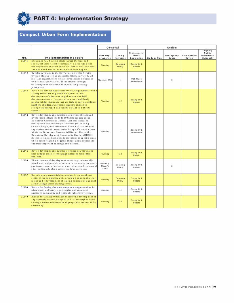
G R O W T H P O L I C I E S P L A N 71
PART 4: Implementation Strategy
Compact Urban Form Implementation
L e ad De p t . o r A g e n cy
T im in g ( In ye ar s )
Or d in an ce o r Oth e r
L e g is lat io n Stu d y o r P lanIn te r ag e n cy
C o o r dDe ve lo p m e n t
Re v ie w
On g o in g Pu b lic
Ed u cat io n & Ou tr e ach
C UF-1 En co u rag e n ew h o u s in g s ta rts to w ard th e w es t an d s o u th w e s t s ec to rs o f th e co mmu n ity ; d is co u rag e u rb a n d e v e lo p men t to th e ea s t o f th e ea s t fo rk o f Jacks o n Creek; an d n o rth an d e a s t o f th e Sta te Ro ad 45/46 By p as s .
PlanningOn-going
Po lic yZ oning Ord.
Update
C UF-2 D e v e lo p rev is io n s to th e City ’s exis t in g U tility Se rv ice O v e rlay M a p a s w e ll a s a s s o c ia ted U t ility Se rv ice Bo a rd ru le s an d reg u la t io n s to c rea te s ew er s e rv ice d is t ric ts a s w e ll a s n o n -s e rv ice a rea s . In th e in te rim, s t ro n g ly d is co u ra g e s ew er e xte n s io n s b e y o n d th e p la n n in g ju ris d ic t io n .
Planning, CBU 1USB Rules
A mendmentX
C UF-3 Re v is e th e P lan n ed Re s id en t ia l Ov e rla y req u iremen ts o f th e Z o n in g O rd in an ce to p ro v id e in cen t iv es fo r th e d e v e lo p men t o f mixed -u s e n e ig h b o rh o o d s o n in fill d e v e lo p men t t rac ts . In g en e ra l, h o w e v e r, mu lt ifamily re s id e n t ia l d ev e lo p me n ts th a t a re like ly to s e rv e s ig n ifica n t n u mb ers o f In d ian a U n iv e rs ity s tu d en ts s h o u ld b e s t ro n g ly d is co u rag ed in lo ca t io n s d is tan t fro m th e IU ca mp u s .
Planning 1-2Z oning Ord.
Update
C UF-4 Re v is e d ev e lo p me n t reg u la t io n s to in c rea s e th e a llo w e d lev e l o f re s id en t ia l d en s ity to 100 u n it s p e r a c re in th e Do wn to w n Co mme rc ia l D is t ric t . Lin k th is in c rea s e d d e n s ity w ith req u ired d es ig n s tan d a rd s (i.e . b u ild in g s e tb a ck, h e ig h t , ro o f o rie n ta t io n , b lan k w a ll c o n tro ls ) a n d ap p ro p ria te h is to ric p re s e rv a t io n fo r s p ec ific a re a s lo c a te d w ith in th e D o w n to w n Co mmerc ia l D is tric t . Rev is e th e D o w n to w n D ev e lo p me n t O p p o rtu n ity O v e rlay (D D O O ) d is t ric t to re mo v e h ig h -d en s ity in c en t iv e s in s p ec ific a rea s w h ich co u ld re s u lt in a n e g a t iv e imp ac t u p o n h is to ric an d cu ltu ra lly imp o rtan t b u ild in g s a n d d is t ric ts .
Planning 1Z oning Ord. A mendment
C UF-5 Re v is e d ev e lo p me n t reg u la t io n s fo r n ea r-d o w n to w n a n d n e a r-c amp u s a rea s to en c o u rag e in c re as e d re s id en t ia l d e n s it ie s .
Planning 1-2Z oning Ord.
Update
C UF-6 Direc t co mmerc ia l d ev e lo p men t to exis t in g c o mmerc ia lly zo n ed lan d , an d p ro v id e in ce n t iv es to en co u rag e th e re -u s e an d imp ro v e me n t o f v aca n t o r u n d e r-d ev e lo p ed co mmerc ia l s ite s , p a rt icu la rly a lo n g a rte ria l ro a d w ay c o rrid o rs .
Planning , May or 's Of f ic e
On-going Po lic y
Z oning Ord. Update
X
C UF-7 Re s tra in n ew co mmerc ia l d ev e lo p men t in th e s o u th eas t s e c to r o f th e co mmu n ity w h ile p ro v id in g o p p o rtu n it ie s fo r re -u s e an d red e v e lo p men t o f exis t in g co mme rc ia l la n d s u c h a s th e Co lleg e M a ll s h o p p in g c en te r.
PlanningOn-going
Po lic yZ oning Ord.
Update
C UF-8 Re v is e th e Z o n in g O rd in an c e to p ro v id e o p p o rtu n it ie s fo r mixed u s es , mu lt i-s to ry c o n s tru c t io n a n d s t ru c tu re d p a rkin g in co mmu n ity an d re g io n a l s c a le ac t iv ity ce n te rs .
Planning 1-2Z oning Ord.
Update
C UF-9 A men d th e Z o n in g O rd in an c e to a llo w th e d ev e lo p me n t o f ap p ro p ria te ly lo ca ted , d e s ig n ed an d s ca le d n e ig h b o rh o o d s e rv in g c o mme rc ia l c e n te rs in a ll g eo g rap h ic s e c to rs o f th e co mmu n ity .
Planning 1-2Z oning Ord.
Update
N o . Im p lem en ta tio n M ea su re
G en era l Actio n

72 C I T Y O F B L O O M I N G T O N , I N D I A N A
PART 4: Implementation Strategy
Nurture Environmental IntegrityImplementation
Lead Dept. or Agency
Timing (In years)
Ordinance or Other
Legislation Study or PlanInteragency
CoordDevelopment
Review
Ongoing Public
Education & Outreach
NEI-1 Create a detailed inventory of surface and subsurface karst terrain features in order to develop a protective zoning overlay. After this inventory is completed, areas found to be dense with karst features should receive stronger protection than individual sinkholes. The preservation of sinkhole clusters rather than just individual features is essential to groundwater protection.
CBU, Planning 1-2 X X
NEI-2 Require surface sinkholes and other karst features to be protected by conservation easements. Planning 1-2
Zoning Ord. Update
NEI-3 Update the current Karst Terrain requirements of the Zoning Ordinance to reflect scientifically accepted karst protection practices.
Planning, Environmental Commission
(EC)
1-2Zoning Ord.
Update
NEI-4 Adopt a tree preservation ordinance that emphasizes species diversity, protecting blocks of high quality vegetation and natural corridors, and preserving community wide tree crown coverage.
Planning, EC 1-2Zoning Ord.
Update
NEI-5 Revise landscaping standards to better address tree crown replacement and enhancement; encourage the planting of a range of native vegetation while prohibiting the planting of invasive exotic species; and require long-term bonding for new landscaping.
Planning, EC 1-2Zoning Ord.
Update
NEI-6 Encourage utility placement underground, especially in new developments, to reduce the need to trim the crowns of trees growing underneath utility lines.
PlanningOn-going
PolicyX X
NEI-7 Conduct an environmental inventory of land located within the City planning jurisdiction allowing for the identification of high quality open space and greenspace. This inventory will form the basis of a joint effort between the City and non-profit organizations to explore acquisition opportunities.
Planning, EC 1 X X
NEI-8 Develop an ongoing program to acquire greenspace for passive recreation and conservation with an emphasis on obtaining substantial blocks of environmentally sensitive lands with high quality vegetation. This will be done along with other City land acquisition needs and/or priorities. Specific strategies should include public outreach, pursuing available grants and loans, developing a more effective City-wide funding mechanism, coordinating efforts between City departments and non-profit organizations, and the use of private conservation easements and dedications of land.
Planning, Parks and
Recreation, Mayor's Office
1-2Greenspace Plan, Budget Legislation
X X X
NEI-9 Develop regulations that require water quality best management practices for controlling stormwater runoff. Planning, EC 1-2
Zoning Ord. Update
X
NEI-10 Develop an on-going program, through the assistance of grants, to monitor and evaluate the quality of stormwater runoff in primary drainageways that flow into lakes and subsurface water resources.
Planning, CBUOn-going
PolicyX X
No. Implementation Measure
General Action
G R O W T H P O L I C I E S P L A N 73
PART 4: Implementation Strategy
Lead Dept. or Agency
Tim ing (In years )
Ordinance or Other
Legis lation Study or PlanInteragency
CoordDeve lopm ent
Review
Ongoing Public
Education & Outreach
NEI-11 Create a detailed inventory of all s treams in Bloomington's Planning Jurisdiction. This inventory will identify all perennial, intermittent, and s ignificant ephemeral waterways and natural drainage features including s treams that emanate from or flow to kars t features . A more precise definition of s treams, in accordance with recognized scientific s tream class ification sys tems , will accompany the inventory.
Planning, EC 1-2 X
NEI-12 Revise the exis ting water resource regulations in the Zoning Ordinance to protect water resources us ing graduated buffer zones to prohibit or limit development in sens itive and s treamside trans ition zones .
Planning, EC 1-2Zoning Ord.
Update
NEI-13 Petition FEMA and the Department of Natural Resources to conduct a new flood insurance s tudy of all Special Flood Hazard Areas within the jurisdiction of the City of Bloomington.
Planning 2 X X
NEI-14 Coordinate with the City Utilities Department to s trengthen regulatory controls for pos t-development s tormwater runoff rates .
Planning, CBU 1-2
Zoning Ord. Update, USB
Rules Amendment
X
NEI-15 Revise Zoning and Subdivis ion regulations to require areas located within 100-year floodways as well as intermittent s tream channels to be protected by drainage and conservation easements .
Planning 1-2Zoning Ord.
Update
NEI-16 Require an inspection of parcels proposed for development and the mapping of all environmentally sens itive areas indentified in the inspection prior to development petition filing.
Planning 1Zoning Ord.
Update
NEI-17 Require the usage of such mechanisms as conservation easements and land dedications to preserve environmentally sens itive areas , open space, and greenspace.
Planning 1-2Zoning Ord.
Update
NEI-18 Establish specific density bonus incentives to promote innovation in environmental des ign and greenspace preservation (i.e. clus tering and mixed use development). Planning 1-2
Zoning Ord. Update
NEI-19 Revise Zoning and Subdivis ion regulations for s ites having environmental cons traints to better protect such features as wetlands , s teep s lopes , and water resources . Planning, EC 1-2
Zoning Ord. Update
NEI-20 Coordinate with the Environmental Commiss ion and Indiana Univers ity to develop an on-going program, through the ass is tance of grants , for promoting and educating about sus tainable des ign and development. Specific s trategies include public outreach, workshops and seminar series featuring sus tainable des ign and development experts , incentives to developers , and creation of web and library based sus tainable development resource centers .
Planning 2 X X
No. Implementation Measure
General Action
74 C I T Y O F B L O O M I N G T O N , I N D I A N A
PART 4: Implementation Strategy
Leverage Public CapitalImplementation
Lead Dept. or Agency
Timing (In years)
Ordinance or Other
Legislation Study or PlanInteragency
CoordDevelopment
Review
Ongoing Public Education &
Outreach
LPC-1
Complete a comprehensive public facility analysis, annually update this analysis, and integrate this analysis into the City's capital improvement planning process.
Planning 2 X X
LPC-2
Ensure that the results of the comprehensive public facility analysis are annually reported to the City Plan Commission Planning 2-5 X
LPC-3
Develop and adopt changes to the Zoning Ordinance that allow the Plan Commission to consider the adequacy of current levels of service, based on the comprehensive public facilities analysis, when evaluating a development petition. For roadways, desired Level of Service ratings should be consistent with the GPP's goal of achieving compact urban form.
Planning 2Zoning Ord.
UpdateX X
LPC-4
Develop a more integrated Annual Capital Budget process that addresses community-wide facility needs on a long-term basis.
Planning 2-5 X X
LPC-5Develop neighborhood-specific Capital Improvement Plans to upgrade existing public facilities.
Planning, HAND
1-5Neighborhood
PlansX X
LPC-6
Identify geographic locations where public infrastructure deficiencies exist, and create guidelines to evaluate projects in these areas.
Planning 1-2Zoning Ord.
UpdateX
LPC-7
In areas with infrastructure deficiencies, employ public and private financing mechanisms in order to underwrite capital projects with a significant public benefit.
Mayor's Office, Controller
1-5Creation of TIF
DistrictsX
LPC-8
Use the development process to acquire land at the appropriate locations for public use based on recommendations in the City’s Annual Capital Budget.
Planning 1-5 X X
No. Implementation Measure
General Action

G R O W T H P O L I C I E S P L A N 75
PART 4: Implementation Strategy
Mitigate Traffic Implementation
Lead Dept. or Agency
Timing (In years)
Ordinance or Other
Legislation Study or PlanInteragency
CoordDevelopment
Review
Ongoing Public Education &
Outreach
MT-1
Develop transit-oriented site planning standards as a required component of development and redevelopment projects. Planning 1-2
Zoning Ord. Update
MT-2
Require the siting of future high density multifamily and commercial projects within walking distance to transit routes. Planning 1-2
Zoning Ord. Update
MT-3
Expand the Park and Ride system by creating additional lots in under-served sectors of the City, particularly in proximity to arterial street corridors
Transit, Planning
1-5 X X
MT-4
Pursue an integrated mass transit system between Bloomington Transit and Indiana University, either through the continuation of a universal bus pass system or a merger between the two service agencies
Transit, Planning
1-5 X X
MT-5
Coordinate with Bloomington Transit to study the feasibility of allowing universal transit access for all citizens of Bloomington.
Transit, Planning
1-5 X X
MT-6
Implement alternative transportation projects annually as outlined in the City's Alternative Transportation and Greenways System Plan. Seek to increase current local funding to ensure more rapid plan execution.
Parks & Rec, Public Works,
Planning1-5 X X
MT-7
Identify and solicit transportation enhancement grants to assist in the funding of selected alternative transportation projects such as the construction of a multi-use trail along Jackson Creek and a multi-use trail along the CSX rail corridor.
Parks & Rec, Planning
1-5 X X
MT-8
Require the construction of pedestrian and bicycle facilities that provide safety and convenience in all new and redevelopment projects. Examples of features to be considered are sidewalks, pedestrian crosswalks, sidepaths, bicycle lanes, and bicycle racks.
Planning 1-2Zoning Ord.
Update
MT-9
Create true pedestrian corridors by increasing the number of large species street trees in tree plots and other pedestrian amenities withing the right-of-way.
PlanningOn-going
PolicyX
MT-10
Ensure that designs for new construction and/or the retrofitting of existing intersections provide a safe environment for pedestrians to reduce crossing distances and include pedestrian signalization.
PlanningOn-going
PolicyX
MT-11
Continuously monitor traffic growth along major arterial corridors through the development of an on-going traffic counting program. Additionally, investigate the feasibility of creating an alternative transportation counting program.
Planning, Engineering
1-5 X
MT-12Develop rigorous access management standards for collector and arterial level streets. Planning 1-2
Zoning Ord. Update
MT-13Ensure the provision and connection of street stubs to improve connectivity within all sectors of the community. Planning 1-2
Zoning Ord. Update
MT-14
For street stubs ending in vacant property, install signs indicating that these streets will be connected at the time of future development approval.
Planning, Public Works
2-5Zoning Ord.
UpdateX X
No. Implementation Measure
General Action

76 C I T Y O F B L O O M I N G T O N , I N D I A N A
PART 4: Implementation Strategy
Conserve Community CharacterImplementation
Lead Dept. or Agency
Timing (In years)
Ordinance or Other
Legislation Study or PlanInteragency
CoordDevelopment
Review
Ongoing Public
Education & Outreach
CCC-1
In coordination with the Housing and Neighborhood Development Department, adopt neighborhood plans that will be designed to address housing, land uses, the provision of public infrastructure and services, affordable housing and infill development strategies
Planning, HAND
1-5Neighborhood
PlansX X X
CCC-2
Maintain the current maximum occupancy standard of three (3) unrelated adults within single family residential zoning districts.
Planning 1-5 X
CCC-3
Revise the Zoning Ordinance to include standards for infill development in residential areas that are consistent and compatible with preexisting development.
Planning 1-2Zoning Ord.
Update
CCC-4
Develop a program that provides incentives (i.e. tax abatements or purchase/rehab assistance) for rehabilitating older housing stock in established neighborhoods for affordable housing.
HAND, Mayor's Office
1Tax Abatement
Criteria amendment
X X
CCC-5
Establish site planning and design standards for development and redevelopment in the downtown areas that emphasize compatibility of form with existing structures using a public community process directed by a professional urban design consultant.
Planning 1Zoning Ord.
Update
CCC-6
Expand the geographic boundaries of the Downtown Commercial zoning district while ensuring appropriate protection of structures and districts of historic importance. Work in cooperation with a professional urban design consultant in this process.
Planning, Historic
Preservation Commission
(HPC)
1-2Zoning Ord.
Update
CCC-7
Provide public incentives (i.e. tax abatements, design assistance) to facilitate the construction of downtown development projects.
Mayor's Office,
Planning1-2 X
CCC-8
Hire a professional urban planning firm to create, in cooperation with key stakeholder groups, a subarea plan which addresses the long-term viability of the downtown area.
Planning, Dow ntow n Bloomington Commission
1-2 X X X
CCC-9
Ecourage public/private partnerships in the rehabilitation of existing structures downtown and in other areas of the community
Mayor's Office, HAND
1-5 X
CCC-10
Update the City of Bloomington Interim Report on Indiana Historic Sites and Structures Inventory . HAND,HPC 1-2
Historic Designations
X X X
CCC-11
Protect historic areas against erosion and loss via demolition and alteration by using both Historic Conservation Districting and Local Historic Districting.
HAND, HPCOn-going
PolicyHistoric
DesignationsX
CCC-12
Bring interested parties together to formulate and make recommendations regarding demolition delay provisions to be included in the municipal code.
HAND, HPC & Planning
1Demolition Delay
Ordinance
No. Implementation Measure
General Action
G R O W T H P O L I C I E S P L A N 77
PART 4: Implementation Strategy
Sustain Economic and CulturalVibrancy Implementation
Lead Dept. or Agency
Timing (In years)
Ordinance or Other
Legislation Study or PlanInteragency
CoordDevelopment
Review
Ongoing Public
Education & Outreach
SECV-1
Identify and maintain a 20-year supply of appropriately zoned land necessary to accommodate long-term employment needs and report annually on the consumption of such land.
Planning 1-5Zoning Ord.
UpdateX
SECV-2
Assure that adequate infrastructure is installed in conjunction with employment center development. Planning,
Mayor's Off ice
1-5 X
SECV-3
Support the continued installation of fiber optic conduit rings linking key future employment sites within the City of Bloomington.
Planning, ITS, Mayor's Off ice
1-5 X
SECV-4
Revise the Zoning Ordinance to provide a greater flexibility of land uses as well as the ability to incorporate retail service uses within office/employment development projects.
Planning 1-2Zoning Ord.
Update
SECV-5
Designate Economic Development Target Areas (EDTAs) to facilitate tax abatements for redevelopment projects in the following locations: 1) the downtown, 2) arterial roadway corridors, and 3) specific Core Neighborhood areas.
Mayor's Off ice,
Planning1-2 X X
SECV-6
Develop a Brownfields Redevelopment Program that facilitates the re-use of underutilized or abandoned properties.
Planning, Mayor's Off ice
2-3 X X
SECV-7
Develop local building code revisions that encourage redevelopment activities.
Planning, Monroe County Building
Department
2-3
Zoning Ord. Update, Local Building Code Amendments
X
SECV-8
Facilitate the location of a new, upscale hotel facility to capture available tourism income within Bloomington's downtown area.
Mayor's Off ice,
Planning1 X
SECV-9
Increase the usage of artistic displays in both private and public development projects. Planning, Arts
Commission1-5 X X
SECV-10
Work with cultural agencies and economic development agencies to create a promotional program linking economic development with Bloomington's quality of life amenities.
Mayor's Off ice,
Planning2--5 X X
SECV-11
Enhance the marketing of Bloomington's downtown as a retail environment by affirming the theme of historic preservation.
Planning, Historic
Preservation Commission
On-going Policy
SECV-12
Encourage the post office, churches and other institutional uses to remain in the downtown. Planning
On-going Policy
X
No. Implementation Measure
General Action

78 C I T Y O F B L O O M I N G T O N , I N D I A N A
PART 4: Implementation Strategy
Advance Communication andCoordination Implementation
Lead Dept. or Agency
Timing (In years)
Ordinance or Other
Legislation Study or PlanInteragency
CoordDevelopment
Review
Ongoing Public Education &
Outreach
ACC-1
As part of the Interlocal Agreement update, enhance the current permitting arrangement between the City and County in order to make the process more efficient and customer-friendly.
Planning, Mayor's Office, Monroe County
1Interlocal
Agreement Update
X
ACC-2
Enhance the current coordination between the City and County Planning Departments, including both staff and Plan Commission members, to pursue long range planning objectives of mutual interest.
City & County Planning
1-5 X
ACC-3
Study the feasibility of creating a consolidated planning department for the City and County as a method of improving planning and development management.
City & County Planning
3 X X
ACC-4
Inform adjacent neighborhood associations and Common Council district representatives in advance of land development petitions.
Planning 1-5 X X
ACC-5
Require at least one neighborhood briefing, conducted jointly by City staff and the developer, in advance of petition filings that either encompass large acreage or encompass major policy issues.
Planning 1-5 X X
ACC-6
Conduct a forum for citizen input regarding growth and development issues within the City of Bloomington at least once every year.
Planning 1-5 X
ACC-7
Establish regular meetings between Planning Department staff and representative organizations of established neighborhood associations, such as the Council of Neighborhood Associations (CONA), to update these groups on long range planning initiatives and development petitions.
Planning 1-5 X X
ACC-8
Encourage direct developer participation in pre-petition filing meetings, and require attendance by the developer or consultant at Development Review Committee meetings, as a means to augment the search for creative solutions to site planning issues.
Planning 1-5 X X
ACC-9
Utilize development review checklists and procedures designed to enhance the screening and review of projects prior to filing for public hearing review.
Planning 1-5 X
ACC-10
Continue to increase the Planning Department's capacity to adequately respond to citizen complaints concerning the enforcement of zoning and subdivision regulations.
Planning 1-5Possible Budget
Legislation
ACC-11
Pursue an on-going exchange of land development and infrastructure information with Indiana University through regular meetings between Planning/Engineering staffs and the Indiana University Real Estate/Architecture offices.
Planning, Public Works
1-5 X
ACC-12
In coordination with University officials, develop strategies which address planning issues of clear mutual interest (for example: transit connectivity on North Dunn Street and North Woodlawn Avenue, new Park and Ride locations in the southeast sector of the community, and structured parking solutions in the downtown 3rd Street/Atwater area).
Planning, Mayor's Office
2-5 X X
No. Implementation Measure
General Action

FOREWORDpage i
PART 1:Policy Essence
page 1
PART 2:The Geography of
the Policiespage 25
PART 3:Critical Subareas
page 41
PART 4:Implementation Strategy
page 69
PART 5:Master Thoroughfare Plan
page 79
APPENDICESpage 95
Introduction
The previous Master Thoroughfare Plan for the City ofBloomington was adopted in 1981. Since that time,Bloomington’s population has increased from 52,044 to69,291 according to the Year 2000 Census. Moreimportantly, data gathered from the recently completedBloomington/Monroe County Year 2025 TransportationPlan (July 2000) indicates that traffic congestion isgrowing at approximately four times the rate ofBloomington’s population increase. With that in mind, itis not only important to comprehensively update theMaster Thoroughfare Plan, it is even more critical toensure that the updated plan helps address the City’sgoal of mitigating traffic congestion and stimulatingalternative transportation.
The Master Thoroughfare Plan determines the locationand construction standards for all existing and proposedpublic right-of-ways (IC 36-7-4-506). Therequirements of the Master Thoroughfare Plan comeinto play when a private property owner seeks to expandtheir property rights (i.e. through subdivision or rezoningpetitions) or when a public entity seeks to make animprovement to the public right-of-way.
The transportation network physically links land useactivities within the community as well as connectsBloomington to surrounding locations. TheTransportation Vision Statement for the City ofBloomington is found in the Bloomington/MonroeCounty Year 2025 Transportation Plan (July 2000).This vision proposes development of a well-integratedand “all modes” surface transportation system creating anetwork of streets, bicycle and pedestrian pathways,and greenways that transverse the community, connectactivity centers, and link recreation opportunities. Thevision encourages actions to reduce dependency uponautomobiles and to widen the range of alternativetransportation modes.

80 C I T Y O F B L O O M I N G T O N , I N D I A N A
PART 5: Master Thoroughfare Plan
The Master Thoroughfare Plan attempts to implementthe Transportation Vision Statement through thefollowing mechanisms:
• Requiring sidewalks for all new streets as well as during thewidening of existing streets.
• Requiring bike lanes for streets identified as arterials or primarycollectors.
• Reducing the right-of-way and pavement width for all types ofstreet classifications. More specifically, the 2002 MasterThoroughfare Plan greatly reduces the pavement width standardsfor neighborhood streets.
• Requiring street gutters and storm sewers for all new streets aswell as during the widening of existing streets.
Relationship to Other Plans andRegulations
The Master Thoroughfare Plan establishes typical streetcross sections including total width, the widths ofthrough, turn and parking lanes, the widths andplacement of bicycle and pedestrian facilities, medianwidth, and the widths of border areas composed oflandscaping and utilities. The Master Thoroughfare Planalso helps to preserve right-of-way and defineconstruction standards for the transportationimprovements contained in the Bloomington/MonroeCounty Year 2025 Transportation Plan and short-rangetransportation improvements contained in theTransportation Improvement Program. While the long-range transportation plan identifies needed improvementswithin a period of 25 years to accommodate existing andforecasted development, the horizon year of the MasterThoroughfare Plan is 50 years or more.
The Master Thoroughfare Plan also preserves right-of-way and defines construction standards for the locationand types of bicycle and pedestrian facilities defined inthe Alternative Transportation and Greenways SystemPlan.
The Master Thoroughfare Plan does not establish rulesand procedures for dealing with neighborhood trafficconditions, such as traffic calming mechanisms. Theseprocedures have been established within the City’sNeighborhood Traffic Safety Program.
Purpose of the Master Thoroughfare Plan
There are five central purposes accomplished in theMaster Thoroughfare Plan:
1. Preservation of right-of-way: Right-of-way is to be preservedto accommodate existing and future transportation needs(including vehicle, bicycle, and pedestrian needs).
2. Continuity: Strive for continuity in the functional, physicaland aesthetic character of various classifications of majorstreets, transit facilities, bicycle facilities and pedestrianfacilities.
3. Preservation of capacity: Preserve the capacity of majortransportation facilities. The plan establishes a rationalefor access management based on existing and anticipateddevelopment along the major transportation corridors.
4. Preservation of neighborhood character: Preserve thecharacter of existing neighborhoods and neighborhoodstreets. The intent of this plan is not to require existingneighborhood streets to conform to typical cross sections.Traditional neighborhood street character is an importantquality that the City must preserve.
5. Interdepartmental Coordination: The Master ThoroughfarePlan directs governmental entities responsible forconstructing utility and street improvements within thethoroughfare plan network to coordinate all planning andwork schedules in order to complete activities in a timelyand efficient manner.
G R O W T H P O L I C I E S P L A N 81
PART 5: Master Thoroughfare Plan
Street Classifications
Streets are classified according to the service functionfor land use and transportation planning purposes. Theprimary functions of streets are either to connectdestinations or to carry through traffic.Streets are also important because they are central todefining urban environments. Properly designed streetscan help define livable neighborhoods, encouragealternative modes of transportation, as well as enhancethe attractiveness of commercial and civic destinations.The typical cross sections and classification descriptionfor each street type are illustrated on the followingpages.
Streets are functionally classified as “neighborhood” ifthe primary purpose is to provide access to abuttingproperties. Streets are functionally classified as“arterials” if the primary purpose is to serve a largercity-wide role by providing a higher degree of mobility.If a street equally serves to provide access to abuttingproperties and to carry traffic, it is functionally classifiedas a “collector.” These three primary functionalclassifications may be further stratified for planning anddesign purposes. The City of Bloomington streetnetwork has been stratified into five groups:
Neighborhood StreetsNeighborhood streets have the sole function of providingdirect access to abutting land uses and to higher orderstreets. Neighborhood streets provide the lowest levelof mobility and, therefore, generally exhibit the lowesttraffic volumes. Through traffic on these streets isdeliberately discouraged. The 1981 Thoroughfare Plandefined this type of street classification with pavementwidths ranging from 28 to 31 feet and right-of-waywidths ranging from 50 to 60 feet. The proposedThoroughfare Plan greatly narrows both dimensions.
On the Official Thoroughfare Plan Map, a“Neighborhood connecting street” is also identified.Neighborhood connecting streets are indicated in keylocations where proposed street connections arenecessary to improve neighborhood street circulation.
CollectorsCollectors carry low to moderate traffic volumes andprovide a greater balance between access and trafficcirculation within residential, commercial, and industrial
areas. The characteristics of a collector street are largelyrelated to the density, size, and type of abuttingdevelopments. Collectors are classified into the followingtwo subtypes:
• Secondary collectors: Secondary collectors refer to streetsthat collect traffic from streets that are located withinneighborhoods. Secondary collectors are typicallycharacterized by larger right-of-ways, greater pavementwidth, and fewer residential curb cuts in comparison toneighborhood streets.
• Primary collectors: Primary collectors are streets thattypically serve as a link between neighborhood streetsand the arterial system. The primary collectors in the Cityof Bloomington incorporate transit, bicycle and pedestrianfacilities within the public right-of-way.
ArterialsThe arterial street is designed to provide a higher degreeof mobility than the collector streets and most oftenserve longer trips within the city. The arterial streetnetwork serves a larger city-wide function facilitatingemployment generated trips and connecting majordestinations such as the downtown district, industrialareas, suburban commercial centers, residential areas,and other key activity centers. The following twosubtypes are typical arterial street designations:
• Secondary arterials: Secondary arterials serve trips ofmoderate length and offer a lower level of mobility thando primary arterial streets. This class interconnects withthe primary arterials, and distributes traffic to smaller areas.Secondary arterials are typically characterized by moderateto heavy traffic volumes and incorporate transit, bicycleand pedestrian facilities in the public right-of-way.
• Primary arterials: Primary arterials are designed to carrythe highest traffic volumes within the street network. Theprimary arterials in the City of Bloomington incorporatetransit, bicycle and pedestrian facilities within the publicright-of-way. Unlike freeways, primary arterials typicallycontain at-grade intersections; however, some manner ofaccess control is still highly desirable.
Note: Within the primary arterial street network, StateRoad 37 is the only thoroughfare classified as aFreeway/Expressway. This sub-category ischaracterized by grade-separated intersections, withoccasional intersections being signalized for localtraffic access.
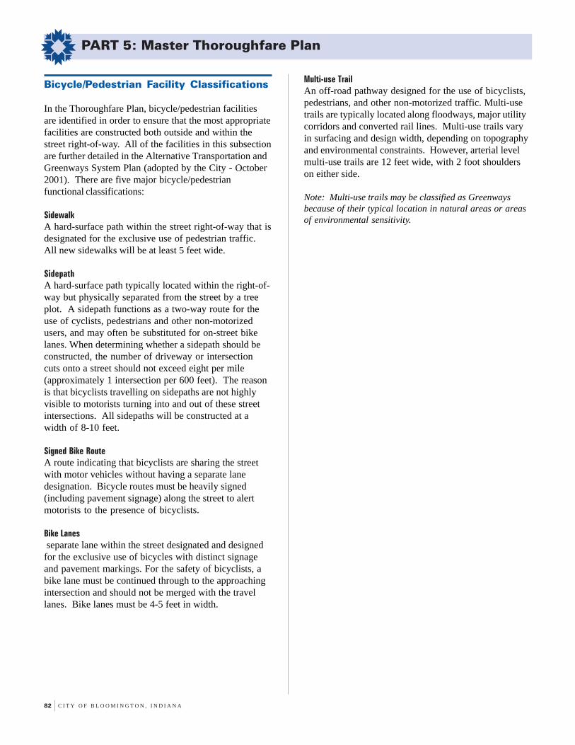
82 C I T Y O F B L O O M I N G T O N , I N D I A N A
PART 5: Master Thoroughfare Plan
Bicycle/Pedestrian Facility Classifications
In the Thoroughfare Plan, bicycle/pedestrian facilitiesare identified in order to ensure that the most appropriatefacilities are constructed both outside and within thestreet right-of-way. All of the facilities in this subsectionare further detailed in the Alternative Transportation andGreenways System Plan (adopted by the City - October2001). There are five major bicycle/pedestrianfunctional classifications:
SidewalkA hard-surface path within the street right-of-way that isdesignated for the exclusive use of pedestrian traffic.All new sidewalks will be at least 5 feet wide.
SidepathA hard-surface path typically located within the right-of-way but physically separated from the street by a treeplot. A sidepath functions as a two-way route for theuse of cyclists, pedestrians and other non-motorizedusers, and may often be substituted for on-street bikelanes. When determining whether a sidepath should beconstructed, the number of driveway or intersectioncuts onto a street should not exceed eight per mile(approximately 1 intersection per 600 feet). The reasonis that bicyclists travelling on sidepaths are not highlyvisible to motorists turning into and out of these streetintersections. All sidepaths will be constructed at awidth of 8-10 feet.
Signed Bike RouteA route indicating that bicyclists are sharing the streetwith motor vehicles without having a separate lanedesignation. Bicycle routes must be heavily signed(including pavement signage) along the street to alertmotorists to the presence of bicyclists.
Bike Lanes separate lane within the street designated and designedfor the exclusive use of bicycles with distinct signageand pavement markings. For the safety of bicyclists, abike lane must be continued through to the approachingintersection and should not be merged with the travellanes. Bike lanes must be 4-5 feet in width.
Multi-use TrailAn off-road pathway designed for the use of bicyclists,pedestrians, and other non-motorized traffic. Multi-usetrails are typically located along floodways, major utilitycorridors and converted rail lines. Multi-use trails varyin surfacing and design width, depending on topographyand environmental constraints. However, arterial levelmulti-use trails are 12 feet wide, with 2 foot shoulderson either side.
Note: Multi-use trails may be classified as Greenwaysbecause of their typical location in natural areas or areasof environmental sensitivity.

G R O W T H P O L I C I E S P L A N 83
PART 5: Master Thoroughfare Plan
Notes: (a) Wider right-of-way near intersections might be required for turn lanes. Right-of-way may be reduced in built out areas.(b) An 8’ sidepath accommodating both bicycle and pedestrian traffic may be substituted provided the street has a limited number of
access points or is located in a low-density area.(c) A 14’ left-turn lane might be required when a median does not provide traffic separation.
Typical Street Cross Section Standards OverviewFor quick reference, the below table notes the typicalcross section standards by road classification.
Through Lanes
Auxiliary Lanes
Parking Lanes Bike Lane
Curb & Gutter (each side) Tree Plot
Sidewalk (each side)
Neighborhood Street 50' 21 if density
requiresNone 10' None 8' None 6" 4.5' 5'
Secondary Collector 55' 21 if density
requiresNone 11' None 8' None 6" 6.5' 5'
Primary Collector 65' 21 if density
requiresNone 11' None 8' 4' (b) 6" 7.5' 5'
Secondary Arterial 80' (a) 21 if density
requires14' (c) 12' 12' 8' 4' (b) 6" 7.5' 5'
Primary Arterial 100' (a) 41 if density
requires14' (c) 12' 12' 8' 4' (b) 6" 7.5' 5'
Median Divider
Functional Class
Border Section Pavement Cross Section Number of Moving Lanes
Number of Parking Lanes
Minimum Right-of-
Way
Typical Cross Sections IntroductionOn the following pages are typical cross sections andtext descriptions for:
1. Existing Core Neighborhood .................................... pg 84
2. Neighborhood Streets ............................................. pg 85
3. Secondary Collectors ............................................. pg 86
4. Primary Collectors .................................................. pg 87
5. Secondary Arterials ................................................ pg 88
6. Primary Arterials .................................................... pg 90
Each of these sections states the typical characteristics,priorities for the right-of-way, and examples of trafficmanagement features. Pictures and illustrations areincluded to better depict the “typical” features of eachtype of street.
Typical Street Cross Section Standards

84 C I T Y O F B L O O M I N G T O N , I N D I A N A
PART 5: Master Thoroughfare Plan
The core neighborhood streets in Bloomington representa high percentage of the total road mileage in the areasurrounding the downtown. Many of these streets arequite narrow in width in comparison to theneighborhood streets that were constructed in the pastfew decades. The cross-sections of the existing coreneighborhood streets are considered an importantelement of the residents’ living environment and oftenserve as a meeting place for residents. It should benoted that many of these streets feature cross-sectionsdifferent from what is outlined in the following pages.In order to preserve neighborhood fabric, existing coreneighborhood streets shall not be required to conform tothe cross section standards that are being proposed formore suburban environments.
Typical Characteristics of a Existing Core Neighborhood Street:• Total right-of-way – varies
• Travel lane widths – typically 8 to 10 feet
• On-Street parking included
• Bike lanes – no lanes are included because of lower trafficvolumes and speed
• Sidewalks and street trees vary; often there is not enough roomfor both elements
Priority For the Right-of-Way:• Primary Priority Elements
- On-Street parking- Residential access- Neighborhood preservation
• Secondary Priority Elements- Width of travel lanes- Sidewalks
• Examples of Traffic Management Features- On-street parking- Street trees- Narrower travel lanes- Reduced pedestrian crossing distances at intersections
(using curb extensions and other measures if necessary)- Traffic circles
Existing Core Neighborhood Streets
William Street at 9th Street looking south
Jackson Street at 3rd Street looking north
Waldron Street at 6th Street looking south
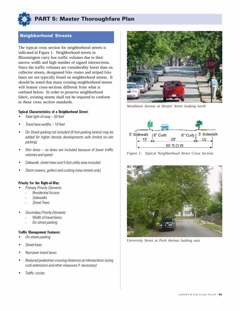
G R O W T H P O L I C I E S P L A N 85
PART 5: Master Thoroughfare Plan
The typical cross section for neighborhood streets isindicated in Figure 1. Neighborhood streets inBloomington carry low traffic volumes due to theirnarrow width and high number of signed intersections.Since the traffic volumes are considerably lower than oncollector streets, designated bike routes and striped bikelanes are not typically found on neighborhood streets. Itshould be noted that many existing neighborhood streetswill feature cross-sections different from what isoutlined below. In order to preserve neighborhoodfabric, existing streets shall not be required to conformto these cross section standards.
Typical Characteristics of a Neighborhood Street:• Total right-of-way – 50 feet
• Travel lane widths – 10 feet
• On-Street parking not included (8 foot parking lane(s) may beadded for higher density developments with limited on-siteparking)
• Bike lanes – no lanes are included because of lower trafficvolumes and speed
• Sidewalk, street trees and 5 foot utility area included
• Storm sewers, gutters and curbing (new streets only)
Priority For the Right-of-Way:• Primary Priority Elements
- Residential Access- Sidewalks- Street Trees
• Secondary Priority Elements- Width of travel lanes- On-street parking
Traffic Management Features:• On-street parking
• Street trees
• Narrower travel lanes
• Reduced pedestrian crossing distances at intersections (usingcurb extensions and other measures if necessary)
• Traffic circles
Neighborhood Streets
University Street at Park Avenue looking east
Woodlawn Avenue at Hunter Street looking north
Figure 1: Typical Neighborhood Street Cross Section
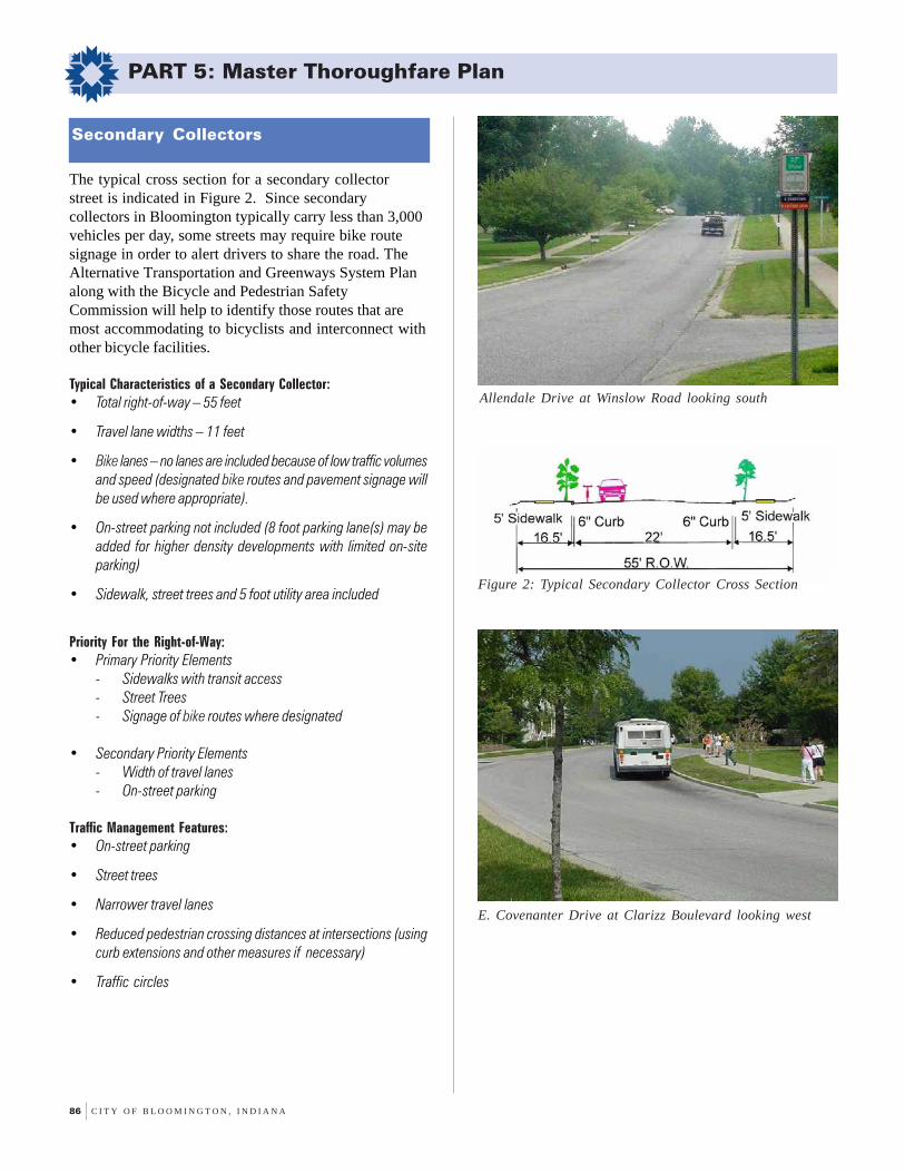
86 C I T Y O F B L O O M I N G T O N , I N D I A N A
PART 5: Master Thoroughfare Plan
The typical cross section for a secondary collectorstreet is indicated in Figure 2. Since secondarycollectors in Bloomington typically carry less than 3,000vehicles per day, some streets may require bike routesignage in order to alert drivers to share the road. TheAlternative Transportation and Greenways System Planalong with the Bicycle and Pedestrian SafetyCommission will help to identify those routes that aremost accommodating to bicyclists and interconnect withother bicycle facilities.
Typical Characteristics of a Secondary Collector:• Total right-of-way – 55 feet
• Travel lane widths – 11 feet
• Bike lanes – no lanes are included because of low traffic volumesand speed (designated bike routes and pavement signage willbe used where appropriate).
• On-street parking not included (8 foot parking lane(s) may beadded for higher density developments with limited on-siteparking)
• Sidewalk, street trees and 5 foot utility area included
Priority For the Right-of-Way:• Primary Priority Elements
- Sidewalks with transit access- Street Trees- Signage of bike routes where designated
• Secondary Priority Elements- Width of travel lanes- On-street parking
Traffic Management Features:• On-street parking
• Street trees
• Narrower travel lanes
• Reduced pedestrian crossing distances at intersections (usingcurb extensions and other measures if necessary)
• Traffic circles
Secondary Collectors
Allendale Drive at Winslow Road looking south
Figure 2: Typical Secondary Collector Cross Section
E. Covenanter Drive at Clarizz Boulevard looking west

G R O W T H P O L I C I E S P L A N 87
PART 5: Master Thoroughfare Plan
The typical cross section for a primary collector street isindicated in Figure 3. Since primary collector streets inBloomington typically carry between 3,000 to 10,000vehicles per day, bike lanes that interconnect with signedbike routes and neighborhood streets are required. In lieuof bike lanes, an 8 foot sidepath may be considered onone side of the street provided the street has a limitednumber of access points or is located in a low-densityarea.
Typical Characteristics of a Primary Collector:• Total right-of-way – 65 feet
• Travel lane widths – 11 feet
• Bike lanes – 4 foot (an 8 foot sidepath may be substituted ifappropriate)
• On-street parking not included (8 foot parking lane(s) may beadded for higher density developments with limited on-siteparking)
• Sidewalk, street trees and 5 foot utility area included
Priority For the Right-of-Way:• Primary Priority Elements
- Sidewalks with transit access- Street Trees- Bike lanes (or other bicycle facilities)
• Secondary Priority Elements- Number and width of travel lanes
Traffic Management Features:• Street trees
• High visibility cross-walks
• Narrower travel lanes
• Reduced pedestrian crossing distances at intersections (usingcurb extensions and other measures where appropriate)
• Roundabouts
Primary Collectors
Figure 3: Typical Primary Collector Cross Section
N. Washington Street at 6th Street looking north
Monroe Street at 14th Street looking south

88 C I T Y O F B L O O M I N G T O N , I N D I A N A
PART 5: Master Thoroughfare Plan
The typical cross section for a secondary arterial streetis indicated in Figure 4. These two-lane divided streetsin Bloomington typically carry between 10,000 to 20,000vehicles per day (depending upon the number of trafficsignals per mile). A median of 14 feet provides motoristswith a left-turn lane into and out of the arterial street.
Due to higher traffic volumes, 4 foot bike lanes thatinterconnect with signed bike routes and neighborhoodstreets are required. In lieu of bike lanes, an 8 footsidepath may be considered on one side of the streetprovided the street has a limited number of access pointsor is located in a low-density area.
Typical Characteristics of a Secondary Arterial:• Total right-of-way – 80 feet
• Median width – 14 feet or wider
• Travel lane widths – 12 feet
• Bike lanes – 4 foot lanes (an 8 foot sidepath may be substitutedif appropriate)
• On-street parking not included (8 foot parking lane(s) may beadded for higher density developments with limited on-siteparking)
• Sidewalk, street trees and a utility area included
Priority For the Right-of-Way:• Primary Priority Elements
- Sidewalks with transit access- Tree plots- Bike lanes (or other bicycle facilities)
• Secondary Priority Elements- Width of travel lanes- Median- Left-turn lanes
Traffic Management Features:• Street trees and landscaped medians
• Narrower travel lanes
• Reduced pedestrian crossing distances at intersections
• Roundabouts
• Acceleration and deceleration lanes
• Wider turning radius at intersections and access points
• Synchronization of traffic signals
Secondary Arterials
Kinser Pike with the golf course to the left looking south
10th Street at Fee Lane looking east
Figure 4: Typical Secondary Arterial Cross Section
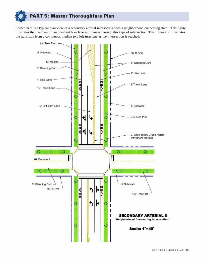
G R O W T H P O L I C I E S P L A N 89
PART 5: Master Thoroughfare Plan
Shown here is a typical plan view of a secondary arterial intersecting with a neighborhood connecting street. This figureillustrates the treatment of an on-street bike lane as it passes through this type of intersection. This figure also illustratesthe transition from a continuous median to a left-turn lane as the intersection is reached.

90 C I T Y O F B L O O M I N G T O N , I N D I A N A
PART 5: Master Thoroughfare Plan
The typical cross section for a primary arterial street isindicated in Figure 6. This four-lane divided street cantypically carry over 20,000 vehicles per day (dependingupon the number of traffic signals per mile). Due to thishigher traffic volume, a continuous turn lane (with orwithout a median barrier) is recommended. A median of14 feet provides motorists with a left-turn lane into andout of the arterial street.
Due to higher traffic volumes, 4 foot bike lanes thatinterconnect with signed bike routes and neighborhoodstreets are required. In lieu of bike lanes, an 8 footsidepath may be considered on one side of the streetprovided the street has a limited number of access pointsor is located in a low-density area.
Typical Characteristics of a Primary Arterial:• Total right-of-way – 100 feet
• Median width – 14 feet or wider
• Travel lane widths – 12 feet (4 lanes)
• Bike lanes – 4 foot or wider (an 8 foot sidepath may be substitutedif appropriate)
• On-street parking not included (8 foot parking lane(s) may beadded for higher density developments with limited on-siteparking)
• Sidewalk, street trees and a utility area included
Priority For the Right-of-Way:• Primary Priority Elements
- Sidewalks with transit access- Street trees- Bike lanes (or other bicycle facilities)
• Secondary Priority Elements- Number and width of travel lanes- Median
Traffic Management Features:• Streets trees and landscaped medians
• Consolidated driveways
• Reduced pedestrian crossing distances
• Roundabouts
• Acceleration and deceleration lanes
• Synchronization of traffic signals
Primary Arterials
Walnut Street and College Avenue at State Road 45/46Bypass looking south
Winslow Road and High Street Roundabout looking east
Figure 6: Typical Primary Arterial Cross Section
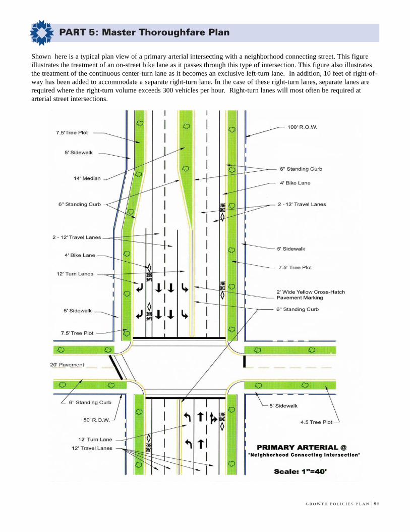
G R O W T H P O L I C I E S P L A N 91
PART 5: Master Thoroughfare Plan
Shown here is a typical plan view of a primary arterial intersecting with a neighborhood connecting street. This figureillustrates the treatment of an on-street bike lane as it passes through this type of intersection. This figure also illustratesthe treatment of the continuous center-turn lane as it becomes an exclusive left-turn lane. In addition, 10 feet of right-of-way has been added to accommodate a separate right-turn lane. In the case of these right-turn lanes, separate lanes arerequired where the right-turn volume exceeds 300 vehicles per hour. Right-turn lanes will most often be required atarterial street intersections.
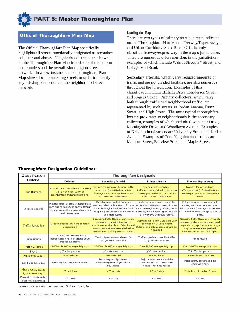
92 C I T Y O F B L O O M I N G T O N , I N D I A N A
PART 5: Master Thoroughfare Plan
The Official Thoroughfare Plan Map specificallyhighlights all streets functionally designated as secondarycollector and above. Neighborhood streets are shownon the Thoroughfare Plan Map in order for the reader tobetter understand the overall Bloomington streetnetwork. In a few instances, the Thoroughfare PlanMap shows local connecting streets in order to identifykey missing connections in the neighborhood streetnetwork.
Official Thoroughfare Plan MapReading the MapThere are two types of primary arterial streets indicatedon the Thoroughfare Plan Map – Freeway/Expresswaysand Urban Corridors. State Road 37 is the onlyclassified freeway/expressway in the map’s jurisdiction.There are numerous urban corridors in the jurisdiction,examples of which include Walnut Street, 3rd Street, andCollege Mall Road.
Secondary arterials, which carry reduced amounts oftraffic and are not divided facilities, are also numerousthroughout the jurisdiction. Examples of thisclassification include Hillside Drive, Henderson Street,and Rogers Street. Primary collectors, which carryboth through traffic and neighborhood traffic, arerepresented by such streets as Jordan Avenue, DunnStreet, and High Street. The most typical thoroughfarelocated proximate to neighborhoods is the secondarycollector, examples of which include Covenanter Drive,Morningside Drive, and Woodlawn Avenue. Examplesof Neighborhood streets are University Street and JordanAvenue. Examples of Core Neighborhood streets areMadison Street, Fairview Street and Maple Street.
Thoroughfare Designation Guidelines
Source: Bernardin, Lochmueller & Associates, Inc.
Collector Secondary Arterial Prim ary Arterial Freew ay/Expressw ay
Trip DistanceProvides for short-distance (< 3 miles)
traf f ic movement betw een neighborhood and arterial systems.
Provides for moderate-distance traf f ic movement (about 3 miles) w ithin
Bloomington and betw een Bloomington and adjacent communities.
Provides for long-distance traf f ic movement (+3 miles) betw een Bloomington and other communities
w ithin the metropolitan area.
Provides for long-distance traf f ic movement (+ 3 miles) betw een
Bloomington and other metropolitan areas.
Access Control
Provides direct access to abutting land uses and some access control through the spacing and location of drivew ays
and intersections.
Partial access control: moderate service to abutting land uses. Access
control through raised medians, and the spacing and location of drivew ays
and intersections.
Limited access control: very limited service to abutting land uses. Access control through f rontage roads, raised medians, and the spacing and location
of drivew ays and intersections.
Full access control: no service to abutting land uses. Access points
limited to other f reew ays and arterials w ith a minimum interchange spacing of
1 mile.
Traffic SeparationOpposing traf f ic f low s are generally
unseparated.
Oppossing traf f ic f low s are physically separated by a raised median or
continuous lef t-turn lane. Collector and arterial cross streets are signalized as w ell as major development entrances.
Opposing traf f ic f low s are physically separated by a raised median.
Collector and arterial cross streets are signalized.
Opposing traf f ic f low s are physically separated and cross streets are grade-
separated except that expressw ays may have at-grade signalized
intersections at least 1 mile apart.
SignalizationTraf f ic signals exist for those
intersections w here an arterial street crosses a collector.
Traf f ic signals are coordinated for progressive movement
Traf f ic signals are coordinated for progressive movement
not applicable
Traffic Volumes 3,000 to 10,000 average daily trips 10,000 to 20,000 average daily trips Over 20,000 average daily trips Over 20,000 average daily trips
Speed ≤ 35 miles per hour ≥ 35 miles per hour ≥ 35 miles per hour 55 to 65 miles per hour
Number of Lanes 2-lane undivided 2-lane divided 4-lane divided 2+ lanes in each direction
Land Use Linkages Main neighborhood interior streetsSecondary activity centers:
occasionally form neighborhood boundaries
Major activity centers and the dow ntow n core; usually form
neighborhood boundaries
Major activity centers and the dow ntow n core
Ideal spacing (same type of roadway)
.25 to .50 mile 0.75 to 1 mile 1.5 to 2 miles Variable, not less than 3 miles
Percent of System (for each class ification)
5 to 10% 5 to 10% 5 to 10% 0 to 5%
Classification Criteria
Thoroughfare Designation

G R O W T H P O L I C I E S P L A N 93
PART 5: Master Thoroughfare Plan
MA
P L
EG
EN
D
Prepared by: Ground Rules, Inc
Master Thoroughfare Plan Map
Proposed Secondary Arterial
Proposed Primary Collector
Proposed Secondary Collector
Proposed Local Street
Municipal Boundary
Additional Planning Jurisdiction
Freeway/Expressway
Primary Arterial
Secondary Arterial
Primary Collector
Secondary Collector
Local Street
Proposed Primary Arterial
College M
all
2nd St.
SR 37
Walnut S
t.
SR 45
SR 46
Hillside Dr.Hillside Dr.
Winslow Rd
Bloomfield R
d.
Bloomfield R
d.
3rd St.
10th St.10th St.
SR 46
SR 4
5
2nd St.
SR 37
Kinser P
k.
Fee Ln.
Walnut S
t.
Roc
kpor
t Rd
Tapp Rd
Henderson
Curry P
k
Sar
e R
d
High S
t
Winslow Rd
High S
t
Sm
ith Rd
Rhorer Rd
College M
all
Snoddy
3rd St.
17th St17th St
3rd St.
College M
all
Henderson
94 C I T Y O F B L O O M I N G T O N , I N D I A N A
PART 5: Master Thoroughfare Plan
Access Control Guidelines
In addition to specifying cross sections for each majortype of street classification, the Thoroughfare Plan alsoidentifies access control measures that should be utilizedfor the design of new streets as well as widenedfacilities. Incorporating such measures provides ahigher level of safety for motorists, bicyclists, andpedestrians. Outlined below is a list of accessmanagement guidelines that should be incorporated intothe City’s development review ordinances.
Neighborhood StreetsThe location, spacing and driveways on neighborhoodstreets is controlled through the issuance ofneighborhood street cut permits. In the case of newsubdivisions, driveway spacing and location should bereviewed during the initial development review process.
Primary and Secondary CollectorsAccess control on collectors is achieved by the spacingand location of driveways and intersections, primarilythrough the street cut permit process. While there is nolimitation on the frequency of driveways, commercialdriveways should be no closer than 200 feet to theapproach of an existing signalized intersection.
Secondary ArterialFor extended or new secondary arterials on new right-of-way, access control is achieved through the raisedmedian. Median crossovers and crossroad intersectionsalong new or extended secondary arterials should be nocloser than 600 feet, and those median crossovers orintersections anticipated to be signalized should be nocloser than 1200 feet. However, driveway spacing maybe closer than 600 feet, provided no driveway exit iswithin 200 feet of the approach to an existing signalizedintersection. Frontage/service roads, rear lot access orjoint driveways are encouraged to reduce the frequencyof commercial driveways, and frontage roads areessential when single-family development faces theextended or new secondary arterial.
In the case of secondary arterials that are widened orreconstructed along existing right-of-way, access rightshave already been established and new or reconstructeddriveways are controlled through “access by permit.”
Nevertheless, efforts should be made to reduce thenumber of median crossovers and the number ofdriveways in the driveway permit process through:
• Construction of a raised median so that left-turns out of abuttingproperties are prohibited and that access to abutting propertiesis limited to right-in/right-out movements. Left-turns from thearterial into the abutting properties may be desirable for hightraffic generators. The retrofitting of a raised median is mostappropriate in congested areas near signalized intersectionswhere frequent high volume commercial driveways create safetyand traffic operational concerns.
• Consolidation of driveways through joint use driveways.
Primary ArterialsFor extended or new primary arterials on new right-of-way, limited access is highly desirable. Access controlon the primary arterial is achieved through the raisedmedian. Median crossovers, crossroad intersections ordriveways along new or extended primary arterialsshould be no closer than 600 feet. Those driveways orintersections anticipated to be signalized should be nocloser than 1200 feet. Frontage/service roads, rear lotaccess or joint driveways should be used so that properspacing of crossroad intersections is achieved. Inparticular, driveways from single-family developmentonto new or extended primary arterials should beprohibited.
In the case of primary arterials that are widened alongexisting right-of-way, access rights are alreadyestablished and the location and design of driveways iscontrolled by the driveway permit. Nevertheless, effortsshould be made to reduce the number of mediancrossovers and the number of driveways through thefollowing measures:
• Closure of median cuts so that left-turns out of abutting propertiesare prohibited and access to abutting properties is limited toright-in/right-out movements. Left-turns from the arterial intoabutting properties may be desirable for high traffic generators.
• Consolidation of driveways through frontage/service roads andjoint use driveways.
• Provision of rear access to properties from parallel neighborhoodstreets in office, retail, commercial, and/or industrial areas.
• Provision of appropriate rear access, in addition to street accessfrom the arterial roadway. This will allow neighborhood accessto retail and service uses without the necessity of having to usethe arterial street.

FOREWORDpage i
PART 1:Policy Essence
page 1
PART 2:The Geography of
the Policiespage 25
PART 3:Critical Subareas
page 41
PART 4:Implementation Strategy
page 69
PART 5:Master Thoroughfare Plan
page 79
APPENDICESpage 95
96 C I T Y O F B L O O M I N G T O N , I N D I A N A
APPENDIX A: Index
Symbols10th Street: 48, 8617th Street: 40, 601995 Zoning Ordinance: 6, 15360 Degree Building Profile: 34, 44, 46, 603rd Street: 22, 48, 50, 58, 62, 907th Street: 489th Street Park: 64
AAccess Control Guidelines: 92Access Management Standards: 14Acuff Road: 18, 44Adams Street: 40, 58, 64Alternative Transportation: 2, 13, 14, 20, 64, 77, 78, 84Alternative Transportation & Greenways System Plan: 36, 78, 80Annexation: 97, 98Arlington Road: 60Arterial, Primary: 79, 81, 88, 89, 90, 92Arterial, Secondary: 79, 81, 86, 87, 90, 92
BBicycle: 2, 3, 13, 14, 29, 33, 34, 48, 62, 64, 77, 78, 79, 80, 83, 84,
85, 86, 87, 88, 89Bicycle Path: 3, 29Big Box: 33Bike Lane: 14, 78, 80, 82, 83, 84, 85, 86, 87, 88, 89Bio-filtration: 9Biodiversity: 8Blank Wall Control: 16, 27, 33Bloomfield Road: 58, 62Bloomington Economic Development Corporation: 42Bloomington Hospital: 18, 35Bloomington Housing Authority: 60Bloomington North High School: 37Bloomington Transit: 13Bloomington/Monroe County Year 2025 Long Range Transportation Plan: 14Bloomington/Monroe County Year 2025 Transportation: 77, 78Bloomington’s Digital Underground: 11, 18Brownfield: 19Brownfield Redevelopment Program: 19Building-Forward: 13, 58Business 37 North: 42Business 37 South: 42Business Park: 44, 46
CCapital Improvement Plan: 11, 12Clarizz Boulevard: 33, 48, 84Clear Creek: 14, 46, 54, 58Clear Creek Trail: 14, 46Collector, Primary: 78, 79, 81, 85, 90, 92Collector, Secondary: 46, 79, 81, 84, 90, 92College Avenue: 88College Mall: 6, 7, 48College Mall Road: 33, 50, 90Commercial Development: 5, 6, 7, 20, 33, 42Common Council: 21Community Activity Center: 32, 60
Compatibility: 28, 31Concurrency: 11Connectivity: 14, 22, 29, 54, 62, 64Conservation Easement: 8, 10, 36Conservation Residential: 30Core Neighborhood: 15, 19, 28Core Residential: 28, 29Council of Neighborhood Associations: 21Council of Neighborhood Improvements: 29Country Club Drive: 64County Courthouse: 20Courthouse Square: 26, 27Critical Subarea: 40, 42, 44, 46, 48, 50, 52, 54, 56, 58, 60, 62, 64CSX: 19, 64CSX Rail Corridor: 14
DDepartment of Natural Resources: 9Design Standards: 10, 16, 33, 56Destination Commercial: 33Development Review: 14, 21, 36, 58, 62, 92Development Review Process: 10Downtown: 6, 11, 15, 16, 17, 19, 22, 26, 27, 28, 33, 64, 79Downtown Commercial: 6, 16Downtown Development Opportunity Overlay: 6Dunn Street: 22, 90
EEconomic Development: 6, 18, 19Economic Development Target Area: 19Employment: 5, 18, 34, 42, 44, 46, 54, 58, 60, 79Employment Center: 16, 18, 34Enforcement: 21Engineering: 22Environment: 5, 8, 9, 10, 16, 29, 30, 36, 39, 46, 62, 64, 80Environmental Protection Agency: 54Environmentally Sensitive: 8, 10, 30, 36, 46
FFacade Improvement Grants: 64Facility Need Overlay District: 12Farmer’s Market: 19Federal Emergency Management Agency: 9Fiber Optic: 18, 34, 42, 44Floodplain: 46, 64Form Districts: 28Fourth Street Art Fair: 19Freeway/Expressways: 79, 90Frontage Road: 42, 60, 92Fullerton Pike: 46
GGateway: 26, 44Gordon Pike: 46, 54Granny Flat: 15Greenspace: 2, 3, 5, 6, 8, 9, 10, 12, 19, 20, 27, 42, 46, 58Greenway: 14, 26, 32, 33, 35, 36, 64, 77, 78, 80, 84Growth: 1, 2, 5, 6, 97, 98, 99Growth Management: 5, 20

G R O W T H P O L I C I E S P L A N 97
APPENDIX A: Index
HHigh Density: 13, 32Hillside Drive: 64, 90Historic Preservation: 6, 16Historic Preservation Commission: 16Hoosierfest: 19Housing: 5, 6, 15, 16, 21, 28, 29, 31, 32, 33, 34, 56, 60, 64, 98Housing and Neighborhood Development: 12, 16
II-69: 42Implementation Strategy: 68Indiana Enterprise Center: 18Indiana University: 1, 13, 18, 19, 21, 22, 28, 35, 97, 98Indiana University Real Estate/Architecture Office: 22Industrial Park: 13, 34Infill: 6, 29, 33Infill Development: 6, 11, 15, 16, 29, 37Infrastructure: 1, 5, 11, 12, 16, 18, 22, 24, 29, 30, 33, 39, 42, 46, 52Interchange: 42, 44, 46Intergovernmental Cooperation: 20Interlocal Agreement: 20Interlocal Cooperation Agreement: 20Interstate 69: 42Ivy Tech: 13
JJackson Creek: 6, 14, 52, 56
KKarst: 5, 8, 9, 46Karst Terrain Zoning Ordinance: 8Kinser Pike: 37, 44, 86Kirkwood Avenue: 26, 58
LLake Griffy: 5, 30Lake Monroe: 5, 30Land Use: 5, 13, 16, 18, 21, 23, 24, 26, 28, 29, 30, 31, 32, 33, 34,
35, 36, 37, 39, 42, 44, 46, 48, 50, 52, 54, 56, 58, 60, 62, 64, 77,79, 98
Land Use Categories: 44, 46, 50, 54Landmark Avenue: 18Levels of Service: 11, 29, 34Long Range Transportation Plan: 11, 14, 44, 56Longview Avenue: 48Lotus Festival: 19
MMaster Thoroughfare Plan: 31, 46, 77, 78McDoel Switchyard: 64Metropolitan Planning Organization: 11, 44Mixed Use: 6, 10, 26, 29, 34, 42, 48, 60, 64Monroe County: 9, 14, 18, 20, 35, 56, 77, 78, 97, 98, 99Monroe County Community School Corporation: 35Monroe County Plan Commission: 6Monroe Street: 60, 85Moores Pike: 29, 36, 40, 50, 56Multi-Use Pathway: 14, 48, 80
NNative Tree Stand: 8, 10Neighborhood: 5, 6, 7, 12, 14, 15, 19, 20, 21, 26, 28, 29, 31, 32, 33,
35, 36, 48, 56, 60, 64, 78, 79, 81, 82, 83, 87, 89, 90, 92Neighborhood Activity Center: 31, 32, 50Neighborhood Commercial: 6, 62Neighborhood Improvements Grant: 29Neighborhood Plan: 15, 16Neighborhood Street: 78, 79, 82, 83, 85, 86, 88, 90, 92Neighborhood Traffic Safety Program: 78New Urban: 37
OOccupancy: 15, 16, 28Official Thoroughfare Plan Map: 79, 90Old State Road 37: 37, 54On-Street Parking: 56, 82, 83, 84, 85, 86, 88Open Space: 5, 8, 9, 10, 26, 29, 30, 32, 33, 36, 37Open space: 36
PPark: 3, 11, 12, 15, 26, 29, 36, 44, 50Parking Garage: 19, 26Parks Department: 11, 14, 36Partnership: 17, 18Patterson Drive: 40, 58PCB: 54Pedestrian: 6, 13, 14, 15, 26, 27, 29, 31, 32, 33, 34, 35, 36, 44, 46,
48, 52, 54, 58, 62, 64, 77, 78, 79, 80, 83, 84, 85, 86, 88, 92Pedestrian Safety Commission: 84Pete Ellis Drive: 48Plan Commission (Bloomington): 11, 12Planned Residential Overlay: 6Planning Department (Bloomington): 9, 11, 12, 20, 21, 35, 68Planning Department (County): 20Planning Jurisdiction: 5, 6, 9, 11, 20, 33, 36, 37, 52, 98, 99Policy Essence: 4Public Facilities: 8, 11, 12, 30Public Transit: 6, 13, 26, 31, 32, 34Public/Semi-Public/Institutional: 35
QQuality of Life: 5, 11, 18, 19, 44Quarry: 37Queens Way: 56
RRe-use: 5, 7, 19, 37Redevelopment: 7, 13, 15, 16, 18, 19, 27, 28, 31, 33, 37, 54, 58, 60,
64, 98Regional Activity Center: 33Rental: 15, 28, 31Right-of-Way: 27, 77, 78, 79, 80, 81, 82, 83, 84, 85, 86, 88, 89, 92Rock Creek Drive: 56Rockport Road: 46Rogers Road: 52Rogers Street: 64, 90
98 C I T Y O F B L O O M I N G T O N , I N D I A N A
APPENDIX A: Index
SSare Road: 29, 36, 52, 56School: 3, 5, 11, 18, 29, 35, 37, 56Seven Guiding Principles: 4, 23, 68Sewer: 5, 6, 11, 26, 29, 30, 31, 32, 34, 36, 42, 44, 46Showers Building: 64Sidepath: 14, 48, 52, 80, 81, 85, 86, 88Sidewalk: 11, 14, 26, 28, 29, 30, 31, 33, 35, 44, 52, 54, 58, 60, 78,
80, 82, 83, 84, 85, 86, 88Signed Bike Route: 80, 85, 86, 88Sinkhole: 8, 62Site Design: 24, 26, 28, 29, 30, 31, 32, 33, 34, 35, 36, 37, 42, 44, 46,
48, 50, 52, 54, 56, 58, 60, 62, 64Smith Road: 36, 50Snoddy Road: 52Southeast Park: 36, 56Southern Indiana Medical Park: 18, 46Special Flood Hazard Area: 9Sprawl: 5, 26, 42State of Indiana: 48, 97State Road 37: 5, 18, 34, 42, 44, 46, 60, 62, 64, 79, 90State Road 37 Corridor: 40, 42State Road 37 Corridor Plan: 34, 42State Road 446: 50State Road 45: 6, 37, 48, 60, 88State Road 45/46 Bypass: 6, 48, 60, 88State Road 46: 6, 37, 48, 60, 88State Road 48: 13Steep Slopes: 5, 8, 9, 10, 30, 46Stormwater: 9, 11, 26, 54, 56, 60, 62Stormwater Ordinance: 9Stormwater Runoff: 9Streetscape: 26, 27, 31, 32, 37Student: 13, 21, 98Student Housing: 21Sustainability: 8
TTapp Road: 18, 37, 40, 46Taste of Bloomington: 19Tax Abatement: 16, 19, 28Tax Increment Finance: 12, 33, 44Thomson: 11, 18, 19Tourism: 18, 19Traffic Congestion: 2, 13, 35, 77Traffic Counting: 14Traffic Mitigation: 13Transit: 5, 13, 22, 26, 33, 36, 48, 58, 60, 62, 78, 79, 84, 85, 86, 88Transit-Oriented Site Planning Standards: 13Transportation 2000 Initiative: 11Transportation Improvement Program: 78Tree Canopy: 9Tree Crown: 9Tree Preservation: 2, 9, 50, 56, 62Twin Lakes Park: 36, 40, 62Two-Mile Fringe: 20
UUnder-Developed: 7Urban Core: 5, 28Urban Corridor: 90Urban Enterprise Zone: 19Urban Infill: 11Urban Residential: 29, 48, 56, 60, 62Urban Sprawl: 5Utility: 6, 8, 11, 12, 20, 29, 83, 84, 85, 86, 88Utility Service Area Overlay: 6Utility Service Board: 6
VValley Forge Drive: 56Victor/Oolitic Trail: 64Vision: 4, 6, 8, 20, 77, 78
WWalker Street: 58Walnut Street: 18, 88, 90Water Quality: 9Watershed: 5, 8, 9, 30, 64Watershed Protection Plan: 64Weimer Road: 37, 46, 62Wetland: 8, 9, 10, 64Wildlife Habitat: 8Winfield Road: 56Woodlawn Avenue: 22, 83, 90
ZZoning Ordinance: 2, 6, 7, 8, 9, 20, 28

G R O W T H P O L I C I E S P L A N 99
APPENDIX B: Glossary

100 C I T Y O F B L O O M I N G T O N , I N D I A N A
APPENDIX B: Glossary (continued)

G R O W T H P O L I C I E S P L A N 101
Population Change
The population of Bloomington and Monroe County bothcontinue to grow steadily. Figure 1 illustrates that boththe city and the county have experienced long termgrowth. Monroe County’s population is a representationof the county’s population in addition to the City ofBloomington’s population. With the exception of the1950-1960 decade, Bloomington and Monroe Countyhave outpaced the rate of population growth in the Stateof Indiana as a whole. For the period between 1980 to2000, Bloomington has increased in population byapproximately 17,300 people, while Monroe County’spopulation increased by an additional 4,500 people. Inthe last decade, Bloomington comprised 75% of the totalcounty growth by adding approximately 8,700 newresidents in contrast to the county’s 2,800 people.Figure 2 displays the population trends over the last 60years for the State of Indiana, Monroe County, and theCity of Bloomington.
Figure 1: Percent Change in Population
0
10
20
30
40
50
60
1950 1960 1970 1980 1990 2000
Year
Per
cen
t C
han
ge
Indiana
Monroe County
Bloomington
Figure 2: Historical Population Trends
INDIANAYEAR % CHANGE % CHANGE % CHANGE
1940 3,427,796 36,534 20,8701950 3,934,224 14.77 50,080 37.08 28,163 34.951960 4,662,498 18.51 59,225 18.26 31,357 11.341970 5,195,000 11.42 85,221 43.9 43,262 381980 5,490,000 5.7 98,785 15.9 52,044 20.31990 5,544,139 0.99 108,978 10.32 60,633 16.52000 6,080,485 9.67 120,563 10.63 69,291 14.28
MONROE COUNTY BLOOMINGTON
HISTORICAL POPULATION TRENDS
Figure 3 below displays the City of Bloomington as aproportion of Monroe County. Bloomington accountsfor more than half of Monroe County in the categoriesof Population, Dwelling Units, and Households. Figure 4illustrates the changes in households and dwelling units,which accompanied population growth. Bothhouseholds and dwelling units grew much more rapidlythan population. The formation of new households, aswell as the growth of single family households, heavilyweighted this change. Bloomington’s share ofpopulation, dwelling units, and households have all
grown from the period of 1970 to 2000. This can beattributed to the growth of Indiana University’senrollment, as well as through annexation that hasoccurred during that time.
Figure 3: Bloomington as a Percent of Monroe County
0
10
20
30
40
50
60
70
1970 1980 1990 2000
Year
Per
cen
t (%
)
Population
Dwelling Units
Households
Figure 4 below also illustrates annual growth ratesoccurring in population, dwelling units and households.During this period, persons per household havecontinually decreased in both Monroe County andBloomington. Decrease in household size is a nationaltrend not unique to Bloomington. In the period between1990 and 2000, Bloomington has outpaced MonroeCounty in the decrease of persons per household.Decreasing household sizes are more common in urbanareas as opposed to rural communities.
Figure 4: Historical Change in Population, Dwelling Units andHouseholds
HISORICAL CHANGE: POPULATION, DWELLING UNITS AND HOUSEHOLDS
1970 1980 1990 2000POPULATION 85221 98785 108978 120563DWELLING UNITS 26738 36213 41948 50846HOUSEHOLDS1 25045 33952 39351 46898PERSONS PER HOUSEHOLD2 3.4 2.91 2.77 2.57
1970 1980 1990 2000POPULATION 43262 52044 60633 69291DWELLING UNITS 12799 17708 22025 28400HOUSEHOLDS1 12040 16940 20983 26468PERSONS PER HOUSEHOLD2 3.59 3.07 2.89 2.62
1970 1980 1990 2000POPULATION 50.76 52.68 55.64 57.47
DWELLING UNITS 47.87 48.9 52 55.85HOUSEHOLDS1 48.07 49.89 53 56.44PERSONS PER HOUSEHOLD2 N/A N/A N/A N/A
1 Households equal occupied dwelling units2 Includes group quarters population
BLOOMINGTON AS A % OF MONROE
MONROE COUNTY
BLOOMINGTON
APPENDIX C: Community Demographic Profile
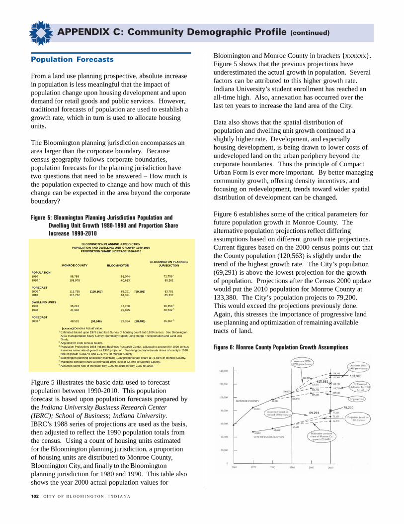
102 C I T Y O F B L O O M I N G T O N , I N D I A N A
APPENDIX C: Community Demographic Profile (continued)
Population Forecasts
From a land use planning prospective, absolute increasein population is less meaningful that the impact ofpopulation change upon housing development and upondemand for retail goods and public services. However,traditional forecasts of population are used to establish agrowth rate, which in turn is used to allocate housingunits.
The Bloomington planning jurisdiction encompasses anarea larger than the corporate boundary. Becausecensus geography follows corporate boundaries,population forecasts for the planning jurisdiction havetwo questions that need to be answered – How much isthe population expected to change and how much of thischange can be expected in the area beyond the corporateboundary?
Figure 5: Bloomington Planning Jurisdiction Population andDwelling Unit Growth 1980-1990 and Proportion ShareIncrease 1990-2010
MONROE COUNTY
POPULATION1980 98,785 52,044 72,756 1
1990 2 108,978 60,633 80,262
FORECAST2000 3 113,755 {120,563} 63,291 [69,291} 83,7812010 115,732 64,391 85,237
DWELLING UNITS1980 36,213 17,708 26,358 4
1990 41,948 22,025 30,532 5
FORECAST2000 6 48,591 {50,846} 27,394 {28,400} 35,367 5
1
2
3
4
5
6 Assumes same rate of increase from 1990 to 2010 as from 1980 to 1990.Maintains constant share at estimated 1980 level of 72.79% of Monroe County.Bloomington planning jurisdiction maintains 1980 proportionate share at 73.65% of Monroe County.
Adjusted for 1990 census counts.
Estimated based upon 1978 Land Use Survey of housing count and 1980 census. See Bloomington Area Transportation Study Survey; Summary Report; Long Range Transportation and Land Use Study.
Population Projections 1988 Indiana Business Research Center, adjusted to account for 1990 census assumes same rate of growth as 1988 projection. Bloomington proportionate share of county's 1990 rate of growth 4.3837% and 1.7374% for Monroe County.
BLOOMINGTON PLANNING JURISDICTION
BLOOMINGTON PLANNING JURISDICTIONPOPULATION AND DWELLING UNIT GROWTH 1980-1990
PROPORTION SHARE INCREASE 1990-2010
BLOOMINGTON
{xxxxxx} Denotes Actual Value
Figure 5 illustrates the basic data used to forecastpopulation between 1990-2010. This populationforecast is based upon population forecasts prepared bythe Indiana University Business Research Center(IBRC); School of Business; Indiana University.IBRC’s 1988 series of projections are used as the basis,then adjusted to reflect the 1990 population totals fromthe census. Using a count of housing units estimatedfor the Bloomington planning jurisdiction, a proportionof housing units are distributed to Monroe County,Bloomington City, and finally to the Bloomingtonplanning jurisdiction for 1980 and 1990. This table alsoshows the year 2000 actual population values for
Bloomington and Monroe County in brackets {xxxxxx}.Figure 5 shows that the previous projections haveunderestimated the actual growth in population. Severalfactors can be attributed to this higher growth rate.Indiana University’s student enrollment has reached anall-time high. Also, annexation has occurred over thelast ten years to increase the land area of the City.
Data also shows that the spatial distribution ofpopulation and dwelling unit growth continued at aslightly higher rate. Development, and especiallyhousing development, is being drawn to lower costs ofundeveloped land on the urban periphery beyond thecorporate boundaries. Thus the principle of CompactUrban Form is ever more important. By better managingcommunity growth, offering density incentives, andfocusing on redevelopment, trends toward wider spatialdistribution of development can be changed.
Figure 6 establishes some of the critical parameters forfuture population growth in Monroe County. Thealternative population projections reflect differingassumptions based on different growth rate projections.Current figures based on the 2000 census points out thatthe County population (120,563) is slightly under thetrend of the highest growth rate. The City’s population(69,291) is above the lowest projection for the growthof population. Projections after the Census 2000 updatewould put the 2010 population for Monroe County at133,380. The City’s population projects to 79,200.This would exceed the projections previously done.Again, this stresses the importance of progressive landuse planning and optimization of remaining availabletracts of land.
Figure 6: Monroe County Population Growth Assumptions

G R O W T H P O L I C I E S P L A N 103
APPENDIX C: Community Demographic Profile (continued)
Figure 7 provides refinement of these projections byslightly altering the assumptions upon which theprojections are based. Initial projections from 1990indicated that Monroe County to would exceed 120,000people in 2010. Current statistics already show MonroeCounty at 120,563 people, with 133,380 peopleprojected for 2010 based on current growth rates.Unless current planning policies are changed,development will be forced out of the planningjurisdiction as developable land area continues todecrease in the City planning jurisdiction.
Figure 7: Monroe County Population Forecast 1990-2010
1980 1990 2000 ABSOLUTE 2010 ABSOLUTE98,785 108,978 A 117,255 {+8277} 120,642 {+3387}
B 117,492 {+8514} 119,533 {+2041}C 117,255 {+8277} 120,894 {+3639}D 120,563 {+11,585} 133,380 {+12,817}
A
B
C
D Actual Census 2000 Figures with projection.
MONROE COUNTY POPULATION FORECAST 1990-2010
Assumes IU student enrollment increases are reduced by 40% from the prior decade in the 1990 to 2000 period and stabilized thereafter. Assumes 1980 to 1990 growth rate applies to 1990 to 2000 period decreases thereafter to 50% of the prior growth rate.
Assumes IBRC projected 1990-2000 growth rate but decrease the level of net migration to zero from 1980 as indicated in the based 1988 projection series of the period 1995-2000. Growth rate projection by IBRC for 2000 to 2010 period. Both adjusted for 1990 actual count.
Assume series for 1990 to 2000 absolute increase, IBRC annual projected rate of increase for the 1990 to 2010 period.

104 C I T Y O F B L O O M I N G T O N , I N D I A N A