HIV Planning Council of New York Committee Structure & Progress Report January 2009
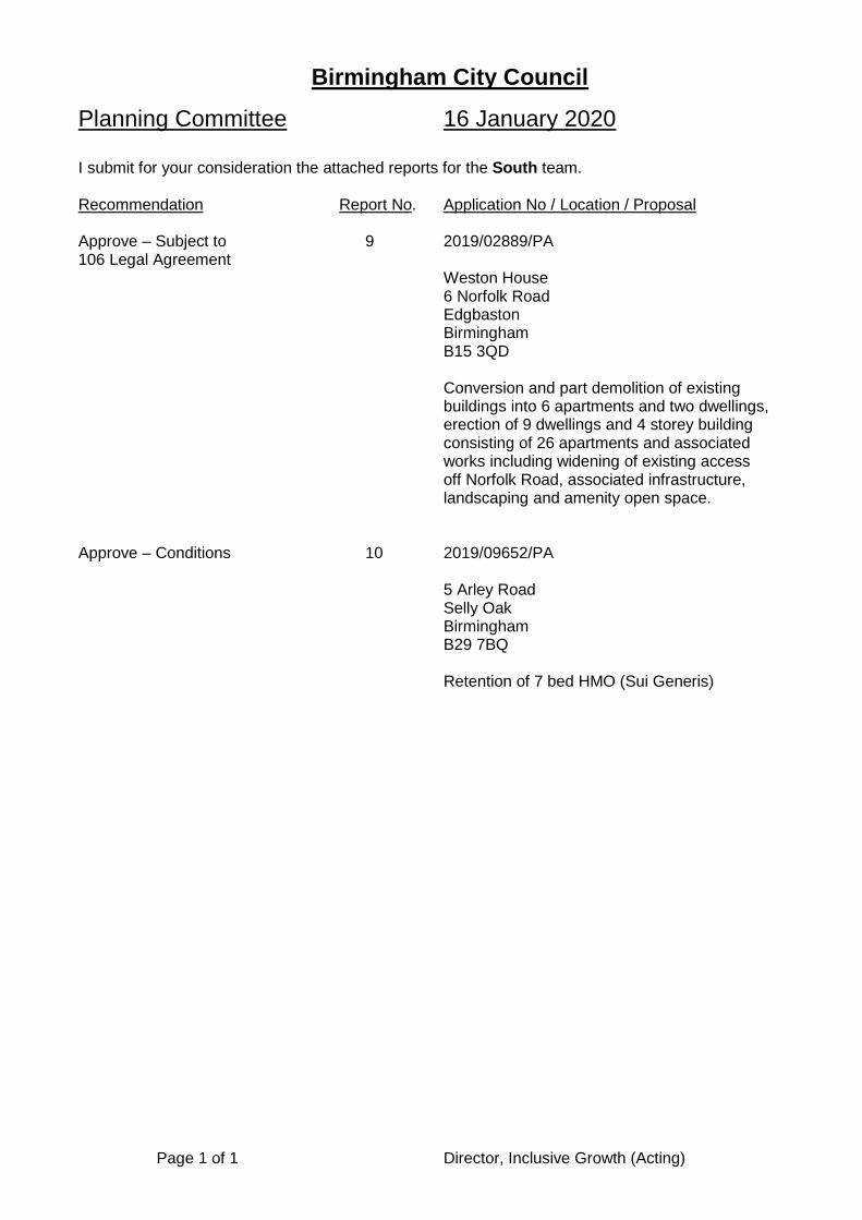
Birmingham City Council
Planning Committee 16 January 2020 I submit for your consideration the attached reports for the South team. Recommendation Report No. Application No / Location / Proposal Approve – Subject to 9 2019/02889/PA 106 Legal Agreement
Weston House 6 Norfolk Road Edgbaston Birmingham B15 3QD
Conversion and part demolition of existing buildings into 6 apartments and two dwellings, erection of 9 dwellings and 4 storey building consisting of 26 apartments and associated works including widening of existing access off Norfolk Road, associated infrastructure, landscaping and amenity open space.
Approve – Conditions 10 2019/09652/PA
5 Arley Road Selly Oak Birmingham B29 7BQ
Retention of 7 bed HMO (Sui Generis)
Page 1 of 1 Director, Inclusive Growth (Acting)
Page 1 of 15
Committee Date: 16/01/2020 Application Number: 2019/02889/PA
Accepted: 04/04/2019 Application Type: Full Planning
Target Date: 27/09/2019
Ward: Edgbaston
Weston House, 6 Norfolk Road, Edgbaston, Birmingham, B15 3QD
Conversion and part demolition of existing buildings into 6 apartments and two dwellings, erection of 9 dwellings and 4 storey building consisting of 26 apartments and associated works including widening of existing access off Norfolk Road, associated infrastructure, landscaping and amenity open space (amended scheme) Recommendation Approve Subject to a Section 106 Legal Agreement 1. Proposal 1.1. This application seeks planning permission for a residential development on the site
known as 6 Norfolk Road. Through the life of the application several sets of amended plans were submitted which altered the design of the apartment building and town houses, the loss of one dwelling, a reduction in car parking provision and changes to the soft landscaping proposed. The final scheme consists of the following elements:
• The part demolition, extension and conversion of 6 Norfolk Road into 6 x 3 bed apartments;
• The conversion of the coach house into 2 x 2 bed properties; • The erection of 2 x 4 bed town houses in semi-detached unit; • The erection of an apartment building consisting of 26 units consisting of 16 x
1 bed, 8 x 2 bed and 2 x 3 bed properties; and • The erection of 7 detached dwellings consisting 3 x 5 bed and 4 x 4 bed
properties
1.2. A total of 81 spaces are provided across the site which results 188% provision across the site. All of the 3, 4 and 5 bedroom units have a minimum of two parking spaces. In addition the detached and semi-detached new build properties have a garage providing additional parking provision. All 1 bedroom apartments have a single parking space allocated.
1.3. The town houses are located to the south of the 6 Norfolk Road building maintaining the existing building line. The building is 2 storeys high with a pitched tiled roof and rendered in white to match the existing property.
1.4. The new apartment building is located to the west and rear of 6 Norfolk Road and is a 4 storey building with a flat roof although the 4th floor is set back on all sides. The building is north facing, fronting onto the proposed access road through the site. The property is constructed of red brick with glazed balconies provided. The car parking for the apartment building is located to the south.
Page 2 of 15
1.5. The 7 detached dwellings are located in a cul de sac west of the new apartment
building. These properties are a mix of two and 3 storeys in height. External materials are traditional red brick and grey roof tiles. The houses have a mix gable end and hipped roofs. Many also have projecting gable features at the front. Each property has an integral garage and garden in excess of 100sqm.
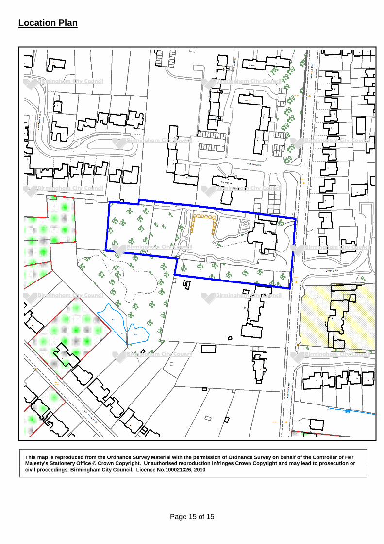
1.6. Site Area: 1.25ha Density: 34.4dph 1.7. Link to Documents 2. Site & Surroundings 2.1. The application site is a rectangular plot of land with a large detached property to the
front that was occupied by a care home which closed approximately 2 years ago. No. 6 is an attractive Georgian property that is sited towards the east of the large plot, fronting onto Norfolk Road. A coach house is located to the north of the main building. To the rear is a large private garden and beyond this is an area that would have historically been used as an allotment and orchard. The site has a single vehicular access from Norfolk Road. The site is surrounded by residential development that varies in design and styles. To the north of the application site are 4 storey apartments dating back to the 1960s. To the east, south and west there are large detached properties from different eras. To the south west there is a Grade II listed property, 16 Norfolk Road.
2.2. Site Location Plan
3. Planning History 3.1. None Relevant
4. Consultation/PP Responses 4.1. Transportation Development – No objections subject to conditions requiring
submission of a construction management plan and widened access to be constructed to city specification at applicant’s expense.
4.2. Regulatory Services – No objections subject to conditions regarding the submission of a contaminated land verification report and the provision of a vehicle charging point.
4.3. West Midlands Police – No objection 4.4. Severn Trent Water – No objection subject to condition for scheme of foul and
service water drainage.
4.5. Fire Service – No objection
4.6. Lead Local Flood Authority – no objection subject to conditions requiring the submission of a sustainable drainage scheme and sustainable drainage operation and maintenance plan.
4.7. Education Services – A contribution of £188,452.22 is required to improve local
schools
Page 3 of 15
4.8. Leisure Services – Off-site public open space requirement of £158,575 required.
4.9. Housing – Off-site contribution towards affordable housing is accepted in this instance. The contribution for 11 dwellings should be calculated on the basis of 30% of average predicted sales price of the 43 units which equates to £627,000.
4.10. Site notice posted, local MP, Councillors, Residents’ Associations and the occupiers
of nearby properties notified of the application. Two further 14 day re-consultations were undertaken following the submission of amended plans. 59 objections have been received in total raising the following matters:
• Insufficient parking is proposed thereby increasing parking on Norfolk Road; • Increased highway safety concerns in an area where accidents have
previously occurred; • Increased traffic and congestion at peak times; • Loss of privacy; • The level of overshadowing is greater than suggested; • Loss of light and breach of the 45 degree code; • Bin store is too close to neighbouring properties; • Increased levels of noise and disturbance; • Increased air pollution; • Affordable housing needed on site; • Increased risk of flooding; • Drainage scheme will impinge on neighbouring properties; • Loss of trees is excessive and unnecessary; • Loss of biodiversity habitats including woodland and orchard; • Harmful to character of the area; • Harmful impact on bats and birds; • 1 bedroom flats are not appropriate in this location; • Loss of view; • Over-development of site; • Development is over-bearing; • Damage to natural environment; • Harmful to the setting of 6 Norfolk Road; • Local schools and GP’s cannot cope with increase in population; • Negative impact on house prices; • Car park too close to neighbouring properties; • Insufficient public consultation; • Proposals are contrary to Calthorpe’s own Scheme of Estate Management;
and • Approval of large backland development would set dangerous precedent
4.11. An objection has been received by Councillor Deidre Alden raising the following
concerns: • the proposals are too dense for the plot and out of keeping with surrounding
properties; • There will be a will a loss of light, view and amenity from all fifteen established
flats in The Regents; • The proposed block of flats in the middle of the site is unattractive and
harmful to the character of the area; • the addition to the front is completely out of keeping; • Increase in traffic near dangerous junction; • The proposed detached houses are sited on plots which are too small; • More parking is needed; and
Page 4 of 15
• Developers have not listened to local residents; 4.12. 2 responses has been received by Preet Kaur Gill MP. She has raised the following
concerns: • Increased traffic on Norfolk Road; • Increased air pollution impacting on human health e.g. asthma, heart disease
and lung cancer; • Increased risk of accidents involving children attending local schools; • Alternative access further south should be utilised; and • Unnecessary loss of too many mature trees on Norfolk Road frontage; • Harm to visual amenity on Norfolk Road through tree loss; • Additional tree planting required to make up for trees removed; • Affordable housing contribution is insufficient; and • Residents have not been properly consulted
4.13. A response has been received by Calthorpe Resident’s Society. They have made
the following concerns: • The density is too high and amounts to over development of the site; • The design and materials of the central apartment block are inappropriate; • Site entrance is too narrow; • Too much tree loss; • Parking too close to neighbouring properties; • Plot 11 is too high in relation No. 7 Norfolk Road; and • Bin store too close to neighbouring properties
5. Policy Context 5.1. The following local policies are applicable:
• Birmingham Unitary Development Plan 2005 (Saved Policies) • Birmingham Development Plan (2017) • Places for Living (Adopted Supplementary Planning Guidance 2001) • The 45 Degree Code (Adopted Supplementary Planning Guidance 1996) • Car Parking Standards SPG • Mature Suburbs SPD
5.2. The following national policy is applicable: • NPPF – National Planning Policy Framework (2019)
6. Planning Considerations 6.1. Principle 6.2. The NPPF defines the three dimensions of sustainable development as being
economic, environmental and social. The NPPF and appeal decisions have established that there must be very good reasons to resist development if it otherwise constitutes sustainable development. There is also a strong emphasis on providing new housing, especially at sustainable locations within urban areas. The NPPF seeks to ensure the provision of sustainable development, of good quality, in appropriate locations and sets out principles for developing sustainable communities. The NPPF promotes high quality design and a good standard of amenity for all existing and future occupants of land and buildings. It encourages the effective use of land by utilising brownfield sites and focusing development in locations that are sustainable and can make the fullest use of public transport,

Page 5 of 15
walking and cycling. The NPPF seeks to boost housing supply and supports the delivery of a wide choice of high quality homes, with a mix of housing (particularly in terms of type/tenure) to create sustainable, inclusive and mixed communities.
6.3. Policy TP28 of the BDP, requires new housing to be; outside flood zones 2 and 3 (unless effective mitigation measures can be demonstrated); served by new or existing infrastructure; accessible to jobs, shops and modes of transport other than the car; capable of remediation; sympathetic to historic, cultural or natural assets; and not in conflict with other specific policies of the plan. In summary the site is located in flood zone 1, close to the Hagley Road and makes efficient use of an underutilised site. This is considered to be a good location to deliver sustainable development and provide a mix of house types to substantially boost the supply of high quality housing.
6.4. Design 6.5. Policy PG3 of the BDP explains that “All new development will be expected to
demonstrate high design quality, contributing to a strong sense of place.” It goes on to explain that new development should: reinforce or create a positive sense of place and local distinctiveness; create safe environments that design out crime and make provision for people with disabilities; provide attractive environments that encourage people to move around by cycling and walking; ensure that private external spaces, streets and public spaces are attractive, functional, inclusive and able to be managed for the long term; take opportunities to make sustainable design integral to development; and make best use of existing buildings and efficient use of land.
6.6. The Mature Suburbs SPD provides more detailed design guidance under a number of categories. It indicates that housing developments need to consider plot size, building form and massing, siting, landscape and boundary treatment, access, parking and traffic impact, design styles, public realm, historic assets, designing out crime, renewable energy and climate change and cumulative impact.
6.7. Norfolk Road is a residential area generally consisting of a number of substantial detached properties that vary in design and style and is considered to be an area of low density although the 4 storey flats on Woodbourne clearly have a much higher density. Policy TP30 seeks minimum densities of 50dph in areas well served by public transport unless local character dictates otherwise. A relatively modest density of 34dph is proposed in this case which clearly takes into account the prevailing character of the wider area.
6.8. Concerns have been raised over the principle of development to the rear of 6
Norfolk Road. However, this is an unusually large plot and there are examples of other infill developments locally in including Aston Bury to the west, Woodbourne to the north and Antringham Gardens to the North West. Therefore the creation of this cul de sac will integrate into the street scene once complete.
6.9. In terms of new build development there are 3 well defined elements; the pair of
semi-detached townhouses on the Norfolk Road frontage, the apartment building behind 6 Norfolk Road and the 7 detached dwellings at the rear of the site.
6.10. The 2 town houses have been designed to appear as a single large dwelling on a
spacious plot reflecting the plot sizes seen in the Edgbaston area. The town houses have been carefully sited to retain the building line on Norfolk Road whilst also not impinging on the setting of the retained property by providing a separation distance
Page 6 of 15
of 7.5m. The town houses are presented as a traditional villa that is white rendered with a hipped tile roof. Headers and footers are provided to the large rectangular windows on the front elevation. The design is sympathetic to the appearance of 6 Norfolk Road and due to its 2 storey height also appears subservient to this property. Whilst the proposed town houses appear higher than the adjacent dwelling, No. 7 Norfolk this is mainly due to the change in levels between the sites. When considering the separation of 11.5m between the properties the change in building heights is considered acceptable. The plot size, building form and massing of the town houses is therefore considered to be acceptable
6.11. A previous iteration of the plans included a large garage block to the rear of the
townhouses which would have incorporated 7 cars. This was considered to dominate the amenity space within the heart of the site. This has since been amended to present 2 single garages within a brick wall. The wall includes recessed areas which provide an opportunity for soft landscaping in front of the wall. This is far less imposing than the previous design solution.
6.12. An apartment building is proposed to the west of the original property. The principle
of an apartment building is difficult to resist with the flatted development known as The Regents is located directly to the north. The building is 4 storeys high and has a flat roof. Whilst the building is 4 storeys high it does not exceed the height of the main building on site reducing views of it from Norfolk Road. The 4th storey has also been set back on all sides further reducing it is prominence meaning that the massing is acceptable in this location. The building is to be constructed entirely of red brick which is typical of the wider area and importantly does not compete with the white rendered retained building. The building has a uniform appearance with large rectangular windows which are surrounded by brick detailing. The building includes glass balconies which have been incorporated between the protruding bays to provide further visual interest. The building form, siting and of the building is therefore considered to be in accordance with the Mature Suburbs SPD.
6.13. The final part of the development is 7 detached properties at the rear of the site.
These 2 and 3 storey properties have found a modest balance between referencing traditional housing and a fresh tack on suburban design. The massing and form of the dwellings fits comfortably within the range of detached properties found within Edgbaston. The large properties sit on good sized plots that are similar in size to those adjacent on Antringham Gardens. The dwellings are sited to provide a coherent layout at the rear of the development with dwellings situated on either side of the cul de sac fronting onto the street. Amended plans have been submitted reducing the number of integral garages creating a more active frontage onto the cul de sac.
6.14. In summary it is considered that the overall design of the proposed scheme would
be acceptable and in keeping with the character of the local area.
6.15. Heritage
6.16. Paragraph 197 of the NPPF states that the effect of an application on the significance of a non-designated heritage asset should be taken into account in determining the application. In weighing applications that directly or indirectly affect non-designated heritage assets, a balanced judgement is required having regard to the scale of any harm or loss and the significance of the heritage asset.
6.17. Whilst not statutorily or locally listed the main building with application site and its
coach house are considered to be heritage assets. Importantly this mid-19th
Page 7 of 15
century stucco villa and its coach house will be retained and converted. Some external works are proposed to the villa consisting of the removal of a two-storey side extension on the south side demolition of part of the single-storey element to the north side. As later additions the removal of these elements is considered acceptable. A new 2 storey extension will replace the 2 storey extension that is to be demolished. The extension is clearly subservient to the main building and has been sensitively designed to complement the non-designated heritage asset.
6.18. Two listed buildings are located to the east of the application site namely; No. 16
Norfolk Road and the Stable Coach House associated with the Calthorpe Estate (both Grade II). It is necessary to consider the impact of this proposal on these historic assets. The Conservation Officer has reviewed the submitted Heritage Statement and considers that the development does not affect the setting of these listed building by virtue of the level of separation and scale of development fronting onto Norfolk Road. I concur with this view.
6.19. In summary, the proposal does not harm any heritage assets that are within or
adjacent to the application site.
6.20. Residential Amenity 6.21. The Places for Living SPG sets out a number of numerical standards which help to
ensure that acceptable amenity standards are provided for the occupiers of new dwellings and retained for the occupiers of adjacent properties.
6.22. The proposal is surrounded by residential development on all sides. The closest property is No. 7 Norfolk Road which is located directly to the south of the application site. This is a large 2 storey property with a front wing set substantially forward of the general building of the property. The proposed town houses are broadly in line with No. 7 meaning that the proposal does not breach the 45 degree code when measured from the nearest habitable windows on either the front or rear elevations of No. 7. The side of the town houses (plot 11) contains no habitable windows meaning no loss of privacy would occur.
6.23. Concerns have been raised over the position of the car park and bin storage in close
proximity to the garden of No. 7. Importantly a separation distance of approximately 4.5m is retained from the car park and bin storage area to the side boundary of No. 7. In addition the latest set of plans shows the removal 8 parking spaces in this area of the site further reducing the impact. This area is heavily planted and further landscaping will be provided to minimise the impact of the car park and bin store.
6.24. Concerns have been raised over the amenity impact of the apartment building. This
is positioned centrally within the site. A distance of 25m is retained from the north facing 3 storey elevation of the apartment building to the south elevation of The Regents apartment building. The 4th storey of the proposed building is recessed creating a separation of 28m. Taking into account the level of planting along the boundary the level of separation is considered sufficient to prevent direct overlooking of the flats in The Regents. A minimum separation of distance of 19m is retained from the three storey element to the site boundary shared with the Regents and this is increased to 22m from the fourth storey. These figures exceed the 5m per storey required by Places for Living SPG ensuring that the private spaces around The Regents will not be overlooked. The top floor penthouse apartments include balconies however these are restricted to the sides (east and west) and rear (south) of the roof space of the building. A distance of 34m is retained to the shared

Page 8 of 15
boundary with No. 7 ensuring that no loss of privacy can occur to this properties private rear garden. A shadow study has also been submitted by the applicant ensuring that the apartment building would not overshadow adjoining properties, such as The Regents.
6.25. No. 29 Antringham Gardens is located to the north of the development site with a rear garden that adjoins the application site. However, there is a distance of 23m between the rear elevation of No. 29 and the side elevation of the nearest proposed 2 storey dwelling (plot 44). This comfortably exceeds the 12.5m required by Places for Living SPG ensuring that the proposal would not appear overbearing. No habitable windows are proposed on the north side elevation of plot 44 ensuring that no loss of privacy could occur.
6.26. Concerns have been raised over general noise and disturbance. It is acknowledged
that there would be some noise and disturbance during the construction phase however this would only be temporary. There is no evidence to suggest that once occupied that there would be undue levels of noise arising from the individual dwellings. No objections have been raised by Regulatory Services in this regard.
6.27. An objection has also been received regarding the loss of a view. However, no one
has right to a view and therefore objections on such grounds carry very little weight in the planning system.
6.28. Each new build dwelling has a garden measuring between 87 and 170sqm thereby
comfortably exceeding the 70sqm required within the Places for Living SPG. The gardens are notably small for the 2 x 2 bed dwellings provided in the former coach house (plots 1 and 2) measuring 27 and 30sqm respectively. This falls below the 52sqm recommended for 2 bed dwellings however there is no scope for further provision around these converted buildings. On balance, smaller gardens are accepted in this instance as it facilitates the conversion and reuse of an attractive coach house building.
6.29. In accordance with the Places for Living SPG 30sqm of open space is required per
flat. An area of 750sqm has been provided for the 26 apartments in the new building. Whilst this falls short of the 780sqm required, the minor shortfall of less than 2sqm per flat will have an inconsequential impact on the occupiers of the development. 188sqm of shared amenity space is provided for the 6 apartments within the converted building. This just exceeds the requirement of 180sqm. The level of private amenity space across the development is therefore acceptable.
6.30. The Nationally Described Space Standards are not yet adopted in Birmingham but they do provide a good yardstick against which to judge proposals, to ensure that the accommodation is of sufficient space to provide a comfortable living environment for the intended occupiers. Due to the executive nature of the scheme all of the dwellings and apartments, including those within the converted buildings are spacious and comfortably exceed the requirements of the NDSS in terms of both of overall floor area and also bedroom sizes. The size of the accommodation is therefore acceptable.
6.31. In summary, the proposal does not have an undue amenity impact on the occupiers
of adjacent properties and creates an acceptable living environment for the proposed occupiers.
6.32. Transportation

Page 9 of 15
6.33. Policy TP38 of the BDP requires that development proposals support and promote sustainable travel and TP44 requires new development to support the delivery of a sustainable transport network.
6.34. A total of 81 spaces provided for the 43 properties, which amounts to an overall provision of 188%. In addition to this houses have a garage incorporated providing additional capacity. Whilst concerns have been raised regarding overspill parking, it is clear that with such a high level of parking on site this is unlikely to occur. In addition the site is in a sustainable location close to the Hagley Road where frequent bus services are available. No objection has been raised by Transportation to the level of parking provision.
6.35. The scheme utilises the existing access which will be widened to allow vehicles to
pass. The Transportation Officer notes that appropriate visibility is provided and consequently raises no objection to the continued use of this access. He has requested conditions requiring the submission of a construction management plan and the need for the widened access to be built to a council specification. I concur with the imposition of these conditions. In summary there are no reasons to resist the proposal on transportation grounds.
6.36. Ecology
6.37. The Council has a duty to consider the impact of any proposal on protected species.
A Preliminary Ecological Appraisal was undertaken by the applicant which identified the need for further survey work including bat, badger and great crested newt surveys. It was determined that there are no badger setts on site however badger were found to forage on the site regularly. No bat roosts were found on site in either trees or buildings. Although some bats were found to utilise the site for foraging this was infrequent and by a small numbers of bats. The site is therefore not considered to be an important bat habitat. The Council’s Ecologist has assessed the submitted reports and raises no objection subject to the provision of a construction ecological mitigation plan and enhancement strategy. The scheme can therefore be implemented without an undue impact on the protected species.
6.38. Landscape and Trees 6.39. There are a significant number of trees located across the site that vary greatly in
size and quality. A detailed tree survey has been undertaken by the applicant which identifies a total of 125 trees and 4 groups of trees within the site. Due to the lack of landscape management a number of the trees are poor quality self-set trees that have grown in the past 20 years. In total 83 individual trees and 4 groups of trees are proposed for removal. This would leave 42 trees (a mix of categories A, B and C) to be retained. These mature trees will provide attractive features across the development and as they are primarily located around the periphery of the site will provide a level of screening. A landscaping condition is proposed which will require tree and shrub planting across the site.
6.40. A Tree Report has been submitted by an objector. The report sets out that more trees will be lost than suggested and the scheme could have been designed more carefully around the trees to allow greater retention. Importantly the scheme as submitted is acceptable to the Tree Officer. It is also of note that the Principal Consultant has not entered the site to undertake his surveys. Subject to conditions requiring appropriate tree planting and tree protection measures for the remaining trees the scheme is considered to be acceptable from a trees and landscaping perspective.

Page 10 of 15
6.41. Financial Contributions
6.42. Due to the size of the scheme contributions towards both affordable housing and public open space are required. In terms of affordable housing, 35% would result in the provision of 15 dwellings. However, in accordance with the NPPG the vacant building credit can be applied to the site. This incentivises developers to redevelop vacant buildings by reducing the affordable housing requirement, in this case down to 11 dwellings. The NPPF states that usually a minimum 10% of homes should be available on site for affordable home ownership. However, In this case the dwellings are of an executive nature which means they would not be truly affordable even with a reasonable discount. In addition just having a small proportion of the apartment block would be impractical for a Registered Social Landlord (RSL) to manage and there would also be expensive management fees associated with the luxury apartments. The Housing Officer considers in this instance it is more appropriate to deliver the affordable housing off-site to ensure that what is delivered is genuinely affordable. This equates to a financial contribution of £627,000. A contribution £158,575 is required by Leisure Services to improve facilities open space facilities in the Edgbaston area.
6.43. As this is a high value area CIL payments of £79 per sqm are required which
amounts to £409,385. It is noted that the Education Department have asked for payment however this is covered by the CIL payment.
6.44. Other Considerations
6.45. Concerns have been raised over the impact on house prices, air quality and
drainage. The impact on house prices is not a material planning consideration. No concerns have been raised by Regulatory Services in relation to air quality in this location. The drainage scheme is considered acceptable to the Lead Local Flood Authority subject to conditions.
6.46. Concerns have also been raised over the extent of public consultation. However,
the level of consultation exceeds statutory requirements. 53 letters were initially sent to adjoining properties and site and press notices were published. In addition 2 periods of re-consultation have taken place.
7. Conclusion 7.1. The proposed development would be in accordance with, and would meet policy
objectives and criteria set out in, the BDP and the NPPF. The scheme is acceptable in terms of its design, amenity, highways, landscape and ecology considerations. It would contribute towards the city’s housing requirements. Therefore the proposal would constitute sustainable development and it is recommended that planning permission is granted subject to the completion of the S106 agreement.
8. Recommendation 8.1. That consideration of planning application 2019/02889/PA be deferred pending the
completion of a planning obligation agreement to secure the following: a) off-site contribution of £627,000 towards affordable housing provision;
b) Off-site open space contribution of £158,575 to improve and maintain facilities in
the Edgbaston area; and

Page 11 of 15
c) Payment of a monitoring and administration fee associated with the legal agreement of £10,000.
8.2 In the absence of a suitable planning obligation agreement being completed to the
satisfaction of the Local Planning Authority on or before 14th February 2020 the planning permission be refused for the following reasons:
a) In the absence of any suitable legal agreement to secure a financial contribution
towards off site affordable housing the proposal would be contrary to TP31 of the Birmingham Development Plan and NPPF.
8.3 That the City Solicitor be authorised to prepare, seal and complete the planning
obligation. 8.4 That in the event of the planning obligation being completed to the satisfaction of the
Local Planning Authority on or before 14th February 2020, favourable consideration be given to this application subject to the conditions listed below agreement.
1 Requires the scheme to be in accordance with the listed approved plans
2 Requires the submission of sample materials
3 Requires the submission of hard and/or soft landscape details
4 Requires the prior submission of earthworks details
5 Requires the submission of boundary treatment details
6 Requires the submission of a landscape management plan
7 Requires the prior submission of level details
8 Requires the submission of a scheme for ecological/biodiversity/enhancement
measures
9 Requires the prior submission of a sustainable drainage scheme
10 Requires the prior submission of a drainage scheme
11 Requires the submission prior to occupation of the properties of a Sustainable Drainage Assessment and Sustainable Drainage Operation and Maintenance Plan
12 Arboricultural Method Statement and Tree Protection Plan - Implementation
13 Limits agreed trees works to 2 years
14 Requires the prior submission of a construction method statement/management plan
15 Requires the submission of a lighting scheme
16 Requires the submission of a contaminated land verification report

Page 12 of 15
17 No more than 75% of the hereby approved new build development shall be occupied until the conversion of both of the retained buildings has been completed.
18 Requires the prior submission of a written scheme of investigation for a historic building recording survey
19 Submission of full specifcation details for any new windows proposed within the retained buildings
20 No development shall commence to the retained buildings until a full suite of materials for the exterior of the retained buildings has been submitted to and approved in writing by the local planning authority. For the avoidance of doubt the materials submitted shall include:
21 Requires the prior submission of a construction ecological mitigation plan
22 Implement within 3 years (Full) Case Officer: Andrew Fulford

Page 13 of 15
Photo(s)
Photo 1: Front elevation of 6 Norfolk Road
Photo 2: View across east from private garden towards rear elevation of 6 Norfolk road and coach house
Page 14 of 15
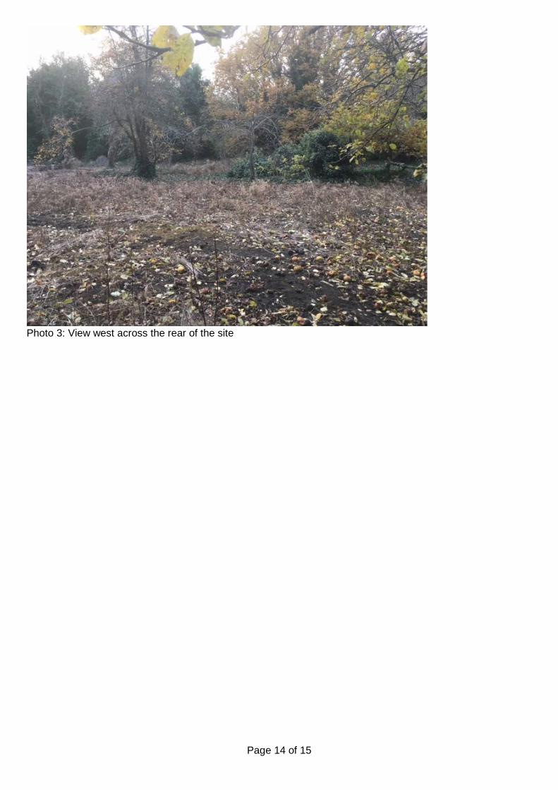
Photo 3: View west across the rear of the site
Page 15 of 15
Location Plan
This map is reproduced from the Ordnance Survey Material with the permission of Ordnance Survey on behalf of the Controller of Her Majesty's Stationery Office © Crown Copyright. Unauthorised reproduction infringes Crown Copyright and may lead to prosecution or civil proceedings. Birmingham City Council. Licence No.100021326, 2010

Page 1 of 7
Committee Date: 16/01/2020 Application Number: 2019/09652/PA
Accepted: 06/12/2019 Application Type: Full Planning
Target Date: 31/01/2020
Ward: Bournbrook & Selly Park
5 Arley Road, Selly Oak, Birmingham, B29 7BQ
Retention of 7 bed HMO (Sui Generis) Recommendation Approve subject to Conditions 1. Proposal 1.1. Consent is sought for the retention of the use as a 7 bedroom large HMO (Sui
Generis) at 5 Arley Road, Selly Oak.
1.2. The development relates to a change of use from a previous small House in Multiple Occupation (HMO) to a 7 bedroom HMO. In total the development comprises of 7 bedrooms over 3 floors (2 bedrooms at ground floor, 3 bedrooms at first floor and 2 bedrooms at second floor). The bedrooms have a floor area of between 11.87 square metres and 7.02 square metres. On the ground floor is an open plan lounge and kitchen with a floor area of 21.14 square metres. There is one bathroom on the ground floor and second floor of the property.
1.3. A rear outdoor amenity space of approximately 26 square metres is provided, with
on street parking available to the front.
1.4. No internal or external alterations are proposed.
1.5. This is a retrospective application, however, there is no current enforcement case relating to the use of this property. It appears that the property has been a large HMO for at least the last 10 years.
1.6. Link to Documents 2. Site & Surroundings 2.1. The application site comprises a traditional mid terrace property with a two storey
and single storey rear wing. The property has had its loft converted with the installation of a dormer window to the rear. Arley Road is set immediately off Bristol Road with a mixture of similar terraced residential properties and commercial properties in the immediate vicinity. Bourn Brook is located in close proximity to the frontage of these properties and the site is within Flood Zone 3.
2.2. Site Location 3. Planning History
Page 2 of 7
3.1. None. 4. Consultation/PP Responses 4.1. Transportation Development – no objections subject to a condition for secure cycle
storage to be installed.
4.2. Regulatory Services – no comments received.
4.3. Environment Agency – stated that a Flood Risk Assessment is required. In view of this information not being submitted they have recommended refusal of the application.
4.4. West Midlands Police – no objections. Properties within Selly Oak are targeted for
crime due to the high proportion of student households in the area. Recommended that an alarm be fitted and doors installed to PAS 24 or equivalent.
4.5. Neighbours and local ward councillors were consulted for the statutory period of 21
days and a site notice displayed. No responses received. 5. Policy Context 5.1. The following local policies are applicable:
• Birmingham Development Plan (BDP) 2017. • Birmingham Unitary Development Plan 2005 (Saved Policies). • Places For Living 2001. • Specific Needs Residential Uses.
5.2. The following national policies are applicable:
• National Planning Policy Framework (2019). 6. Planning Considerations 6.1. This application has been assessed against the objectives of the policies as set out
above.
6.2. The National Planning Policy Framework (NPPF) seeks to ensure the provision of sustainable development, of good quality, in appropriate locations and sets out principles for developing sustainable communities. It promotes high quality design and a good standard of amenity for all existing and future occupants of land and buildings. The NPPF also seeks to boost housing supply and supports the delivery of a wide choice of high quality homes, with a mix of housing (particularly in terms of type/tenure) to create sustainable, inclusive and mixed communities.
6.3. Policy TP27 of the Birmingham Development Plan also states that new housing in
Birmingham is expected to contribute to making sustainable places. All new development will need to demonstrate that it is meeting the requirements of creating sustainable neighbourhoods. Policy TP28 of the plan sets out the proposed policy for housing location in the city, noting that proposals should be accessible to jobs, shops and services by modes of transport other than the car.
Page 3 of 7
6.4. Applications for change of use to Houses in Multiple Occupation also need to be
assessed against criteria in saved policies 8.23-8.25 of UDP and Specific Needs Residential Uses SPG. The criteria includes; effect of the proposal on the amenities of the surrounding area and adjoining premises, size and character of the property, floorspace standards, amount of car parking and the amount of provision in the locality. Policy 8.25 also states that ‘where a proposal relates to a site in an area which already contains premises in a similar use, and/or properties converted into self-contained flats, and/or hostels and residential care homes, and/or other non-residential uses, account will be taken of the cumulative effect of such uses upon the residential character and appearance of the area’.
6.5. The specific needs residential uses SPG is clear that the nature of the type of
people to occupy the premises is not a material planning consideration, and that HMO accommodation has a role to play in providing housing for certain groups in society. The SPG guidelines for internal standards for people having a bedroom and shared living rooms and kitchen are:
• Single bedroom – 6.5 square metres • Double bedroom – 12.5 square metres
6.6. The overall housing objective of the Wider Selly Oak SPD is ‘to maintain a balance
of housing provision, a sustainable and cohesive housing market, and secure a high level of management of the residential environment’. This is in order to ensure that Selly Oak ‘remains a desirable residential area for existing residents, as well as attracting and retaining employees to the university and hospitals - including graduates’. The policy requires that ‘all proposals must secure a significant uplift in the area’s residential offer’.
6.7. The application site is located within a predominately residential area within a sustainable location. Within this area planning permission is not required to change the use of the property from a residential dwelling (Use class C3) to a small scale HMO (Use Class C4). The current permitted fall back use of the property is for 6 bedrooms so the assessment for this application is whether an additional extra bedroom has a detrimental impact on the amenities of the surrounding area. There have been a number of recent appeal decisions in the Bournbrook area regarding the change of use to 8 and 9 bedroom HMOs including decisions at 269 Dawlish Road (APP/P4605/W/19/3220857), 74 Heeley Road (APP/P4605/W/19/3220861) and 68 Harrow Road (APP/P4605/W/18/3207412 and APP/P4605/W/18/3207414). These decisions have overturned previous refusals by the Council highlighting several key issues. Namely, that the Council intentionally left Bournbrook out of the article 4 area and the fact that vast majority of properties are already in use as HMOs. I do not consider that the change of use of this building to a 7 bedroom HMO has any significant further harmful impact on the character of the Bournbrook area or impact on residential amenity to form sustainable grounds upon which to recommend refusal of the application.
6.8. The existing building contains three floors with individual bedrooms and a shared
lounge and kitchen. All of the bedrooms exceed the standards set out in the Specific Needs Residential Uses SPG guidance for single bedrooms. The communal lounge and kitchen area is of a relatively generous size and I consider is sufficient for the number of residents within the property. It is therefore considered that the internal residential environment for existing and future occupiers is acceptable.
Page 4 of 7
6.9. In terms of the residential amenity of future occupiers of the premises, adopted SPG ‘Specific Needs Residential Uses’ advocates that 16 square metres of amenity space should be provided per resident equating to 112 square metres. The property has approximately 26 square metres of private amenity space which is substantially below the required amenity space. However, with the fallback position of a 6 bedroom HMO there would still be a significant shortfall in meeting with this amount of amenity space. It is also noted that in recent appeal decisions the Planning Inspector has not considered this shortfall in terms of lack of private amenity space to be sustainable grounds for refusal of such applications. Gardens of this size are common within the Bournbrook area, particularly in Arley Road, and in light of previous appeal decisions it would be difficult to sustain a refusal on such grounds.
6.10. There would be no internal or external alterations proposed to the property therefore
there is no impact on the character or appearance of the existing building or surrounding area.
6.11. No comments have been received from Regulatory Services, however, I do not
consider that the use of this property as a large HMO would have a harmful impact upon the amenity of existing or future occupiers in terms of noise or disturbance.
6.12. This terraced property is located within a residential street of similar properties. As
with the majority of sites in this location, no off street parking is offered, with residents relying upon the unrestricted on street options. There are regular buses and trains within reasonable walking distance of this site throughout the day. Transportation Development have not raised any objections to the proposal and is not considered the use of the property as a 7 bedroom HMO has a notable impact upon traffic and parking demand at this location. While parking demand is typically heavy within the vicinity it must be acknowledged there are good public transport links. A condition is suggested to provide secure cycle storage in order to encourage residents to consider this alternative mode of travel, which is attached to this permission.
6.13. The Environment Agency have raised concerns in relation to the application in view
of the site being located within Flood Zone 3 and that no Flood Risk Assessment has been submitted. Notwithstanding this, consideration is given to the fact that the property could be used as a 6 bedroom HMO without the need for planning consent. As such, I do not consider the addition of 1 bedroom to this fallback position has any significant impact on flooding or a greater risk to occupiers. Given the property has been in use as a large HMO for a number of years I do not consider a refusal would be reasonable in these circumstances.
6.14. The development does not attract a CIL contribution. 7. Conclusion 7.1. This application is recommended for approval as the development complies with the
objectives of the policies as set out above. I therefore do not consider that there are grounds to recommend refusal for the retention of the use of this property as a 7 bedroom HMO.
8. Recommendation 8.1. Approval subject to the following conditions:
Page 5 of 7
1 Requires the scheme to be in accordance with the listed approved plans
2 A maximum of seven persons' occupancy
3 Requires the submission of cycle storage details Case Officer: George Baker

Page 6 of 7
Photo(s)
Figure 1 – Front elevation of 5 Arley Road

Page 7 of 7
Location Plan
This map is reproduced from the Ordnance Survey Material with the permission of Ordnance Survey on behalf of the Controller of Her Majesty's Stationery Office © Crown Copyright. Unauthorised reproduction infringes Crown Copyright and may lead to prosecution or civil proceedings. Birmingham City Council. Licence No.100021326, 2010
Birmingham City Council
Planning Committee 16 January 2020 I submit for your consideration the attached reports for the City Centre team. Recommendation Report No. Application No / Location / Proposal Approve – Subject to 11 2019/05158/PA 106 Legal Agreement
100 Broad Street City Centre Birmingham B15 1AU Demolition of existing buildings and erection of 61 storey tower to include 503 apartments (Use Class C3), ground floor commercial/retail units (Use Classes A1-A5 , B1a, D1 & D2), flexible upper floor uses (Use Classes A3, A4 and D2), ancillary residents amenity and all associated works
Page 1 of 1 Director, Inclusive Growth (Acting)
Page 1 of 15
Committee Date: 16/01/2020 Application Number: 2019/05158/PA
Accepted: 29/07/2019 Application Type: Full Planning
Target Date: 31/01/2020
Ward: Ladywood
100 Broad Street, City Centre, Birmingham, B15 1AU
Demolition of existing buildings and erection of 61 storey tower to include 503 apartments (Use Class C3), ground floor commercial/retail units (Use Classes A1-A5 , B1a, D1 & D2), flexible upper floor uses (Use Classes A3, A4 and D2), ancillary residents amenity and all associated works Recommendation Approve Subject to a Section 106 Legal Agreement 1. Proposal 1.1. Proposal is for the erection of a 61 storey tower at 100 Broad Street and associated
works.
1.2. The development would comprise of a tower with its primary frontage to Broad Street and 3 storey pavilion building to the rear. Whilst the tower would be a single structure it would be split in half with the two elements staggered. The northern element would comprise a more rectangular form, 59 storeys and a max height of 187.75m whilst the southern element would comprise of sharp angular corners to Broad Street, 61 storeys and a max height of 193.30m. The building materials would primarily feature opaque and clear glazing with a regular rhythmic grid pattern added by the use of vertical titanium fins and expressed horizontal transom on the southern element and a titanium frame, horizontal titanium fins and metal cladding on the northern element. The podium building would be a glazed titanium framed building. Specific details to be agreed.
1.3. A total of 503 apartments would be provided of which 224 flats (44.5%) would be 1
bed 2 person between 51.9-62.2 sqm and 279 flats (55.5%) 2 bed 3/4 persons between 67.2-80.8 sqm. Accommodation would comprise of open plan kitchen/living/dining areas with 1 or 2 bedrooms, bathroom(s) (some ensuite) and storage. The living accommodation would be on floors 4-59.
1.4. The ground floor of the tower would be double height with a partial mezzanine. It
would comprise of reception and storage space in addition to two commercial units which would front Broad Street circa 500sqm. These units are currently speculative and a flexible range of uses are therefore proposed (A1-A5, B1a, D1 and D2).

Page 2 of 15
Fig 1: Proposed visual of site from Fiveways
Fig 2: Extract from Design and Access Statement
Page 3 of 15
1.5. The top two floors of the southern tower element, the 3rd floor of the tower and the podium building would comprise of managed communal amenity spaces for residents use. This would include a gym, rooftop terrace, cinema, workshops, games room, co-working spaces and dining/lounge area with bar/café circa 845sqm.
1.6. No car parking would be provided on site but 250 cycle parking spaces (49.7%)
would be provided. A new layby would be created to Ryland Street and a servicing area would be provided within the rear courtyard area off Essington Street.
1.7. Hard and soft landscaping including approx 20 trees, a new water feature and
seating areas would be provided at ground floor around the site comprising of granite sett paving, resign bound gravel and flush metal inlay, with specific details to be agreed.
1.8. A green roof (approx 134 sqm) would be provided on the podium building and PV
panels would be provided on the tallest element of the tower.
1.9. Information submitted in support of the application includes Air Quality Assessment, Arboricultural Impact Assessment, Arboricultural Report, Archaeology Summary Statement, Aviation Safeguarding Assessment, Built Heritage Statement, Communications Impact Assessment, Daylight and Sunlight Report, Design and Access Statement, Drainage Strategy, Ecological Impact Assessment, Energy Statement, External Lighting Statement, Flue and Extract Ventilation Report, Geo-environmental Desk Study, Housing Market Mix Report, Noise Assessment, Planning Statement (including Statement of Community Involvement), Television Baseline Survey Report, Townscape and Visual Impact Assessment, Transport Statement, Travel Plan, Viability assessment and a Wind and Microclimate Study.
1.10. A Screening Opinion considered the development did not require an ES.
1.11. Link to Documents 2. Site & Surroundings 2.1. Application site is a corner site to Ryland Street and Broad Street (north side), to the
west of the city centre. It is 0.25 hectares and is surrounded by a wide range of uses including residential, hotel, commercial offices, retail and leisure.
2.2. The site is currently occupied by a 4/5 storey office building slightly off-set from the back of pavement, tapering to the corner with Ryland Road. It is a relatively flat site.
2.3. There are no listed buildings or scheduled ancient monuments within or adjoining the site and the site is not within a Conservation Area. The nearest listed buildings are the former Barclays Bank and former Royal Orthopaedic Hospital on Broad Street and the City Tavern Public House (Bishopsgate Street). The nearest Conservation Area is Edgbaston Conservation Area to the south.
2.4. Site location 3. Planning History 3.1. None relevant to application although multiple recent consents for towers along
Broad Street including Moda and Left Bank.

Page 4 of 15
4. Consultation/PP Responses 4.1. Birmingham Airport – No objection subject to a condition to secure a radar
assessment.
4.2. Education and Skills (Employment) – Employment opportunities condition required for the construction period.
4.3. Historic England – No objections but considers that the LPA should be satisfied of
the developments impact on heritage assets across a large area to ensure that it does not negatively impact conservation areas or other heritage assets outside of the city centre.
4.4. Lead Local Flood Authority – No objection to amended information subject to
condition with regard sustainable drainage operation and maintenance plan.
4.5. Leisure Services – No objections subject to public open space contribution of £1,016,600 to be spent on the provision, improvement and/or biodiversity enhancement of public open space and maintenance of Chamberlain Gardens.
4.6. Metro Alliance – No comments.
4.7. Regulatory Services – No objection to the additional information subject to
conditions with regard noise insulation, overheating, odour extract ventilation and plant and machinery limits and land contamination.
4.8. Severn Trent – No objection subject to condition with regard disposal of foul and surface water. Also note there is a public sewer within the application site.
4.9. Sport England – No objection subjection to financial contribution of £478,024 which should be used towards the provision of the IPL swimming pool and playing pitches.
4.10. Transport Development – No objection to amended information subject to conditions
to secure a servicing, delivery and refuse management plan, construction management plan, a S278 Agreement and cycle parking prior to occupation.
4.11. West Midlands Fire – Notes the fire requirements for the building.
4.12. West Midlands Police - Secured by design standards should be met. CCTV should
be provided, appropriate boundary treatment to rooftop terraces and clear demarcation of public/private areas needed.
4.13. Local residents’ associations, neighbours, Ward Councillors and MP were notified.
Site and Press notice displayed. No objections were received. 2 letters of support (including 1 from West Side Bid) welcoming the investment to this part of the city have been received.
5. Policy Context 5.1. Birmingham UDP 2005 saved policies; Birmingham Development Plan 2017; Places
for Living SPG; Places for All SPG; Access for People with Disabilities SPG; Car Parking Guidelines SPD; High Places SPG; Lighting Places SPD; Public Open Space in New Residential Development SPD; Affordable Housing SPG; Planning Policy Guidance and the National Planning Policy Framework.
Page 5 of 15
6. Planning Considerations 6.1. In January 2017 the City Council adopted the Birmingham Development Plan (BDP).
The BDP is intended to provide a long term strategy for the whole of the City and replaced the UDP 2005 with the exception of the saved policies in Chapter 8 of the plan. It makes clear the need for a significant increase in growth. Policy PG1 quantifies this as the provision of 51,000 additional homes within the built up area of the City which should demonstrate high design quality, a strong sense of place, local distinctiveness and creates a safe and attractive environment. Policy GA1 promotes the City Centre as the focus for a growing population and states that residential development will be continued to be supported where it provides well-designed high quality environments with the majority of new housing expected to be delivered on brownfield sites within the existing urban area. Whilst Policy GA1.3 and Policy TP27 emphasise the importance of supporting and strengthening the distinctive characteristics, communities and environmental assets of each area and the need to make sustainable neighbourhoods.
6.2 The application site is located within the Westside growth area, it is well connected to amenities and facilities and is a brownfield site within the existing urban area. The provision of a residential development with ground floor commercial uses, which would complement and supplement the existing amenity provision in the immediate locality accords with this policy provision. I therefore concur with Strategic colleagues who raise no objections in land use policy terms subject to all detailed matters. Layout, scale and design
6.3 Local planning policies and the revised national planning policy (2019) highlight the
importance of creating high quality buildings and places and that good design is a key aspect to achieving sustainable development. Policies PG3 and TP27 state the need for all new residential development to be of the highest possible standards which reinforce and create a positive sense of place as well as a safe and attractive environment. Supplementary documents also provide further guidance for the need for good design including the City’s ‘High Places’ SPG which provides specific advice for proposals which include elements in excess of 15 storeys. It advises that, generally, tall buildings will be accommodated within the City Centre ridge zone and it also advises that tall building will;
• Respond positively to the local context and be of the highest quality in
architectural form, detail and materials; • Not have an unacceptable impact in terms of shadowing and microclimate; • Help people on foot move around safely and easily; • Be sustainable; • Consider the impact on local public transport; and • Be lit by a well-designed lighting scheme.
6.4 The scale of the building ranges from 3 to 61 storeys and is within the city centre
ridge zone, where the development of a tower is acceptable in principle. The building fills most of the plot, encloses the development block within which it sits and provides an active frontage to primary and secondary frontages. Further the applicant has provided comprehensive supporting information within their Design and Access Statement and a Townscape Visual Impact Assessment (TVIA) to demonstrate that
Page 6 of 15
the proposed tower would not have an adverse impact on the street scene or the City’s longer range views, and how it would successfully re-enforce the City’s skyline.
6.5 The design concept creates an elegant and simple building and extends the full
extent of the building, successfully meeting the ground. Following presentation to DRP the design detail has been refined. As a result the crown detail has been amended and the profile of the vertical fins within the glass system on the southern tower element has been refined and a expressed horizontal transom running at floor level on every floor plate has also been introduced to strengthen its grid aesthetic. In addition, a titanium finish has also been added to define the visually subtle, elegant central entrance area on Broad Street which successfully uses proportions that mimic the tower, to create an entrance with a human form and scale and relate to the street scene. Shadow gaps at the corridor ends (details to be secured by condition) have also been added which further accentuates the splitting of the floor plate to reduce the perception of the buildings width and accentuate its gable end slenderness. I also note that the scale and form of the podium building is acceptable given its position close to existing dwellings and amendments to the material colour emphasise its fragmentation and its identity, whilst still enabling it to clearly relate to the main tower.
Fig 3 and 4: Refined crown and ‘grid’ pattern to southern tower element
6.6 The design detailing is also carried through to the proposed hard/soft landscaping in
the public domain. Further, whilst 2 trees would be lost to facilitate the development 20 new trees are identified as part of the hard/soft landscaping proposals which would significantly improve the tree canopy in this locality, soften an existing hard urban environment and improve the sites bio diversity. The overall proposed landscaping would have a positive impact on the visual appearance of the area. Due to presence of trees on the boundary conditions to safeguard their retention are required.
Page 7 of 15
6.7 Therefore, subject to suitable safeguarding conditions, I concur with my City Design Officer that the design, scale and mass of the proposal is acceptable and consider it would result in an architectural statement building which would positively contribute to the city’s skyline on a strategically prominent site within the city centre in accordance with both local and national planning policies.
Heritage 6.8 The site is not within a conservation area and there are no heritage assets within the
site boundary. However a Heritage Statement, supported by the TIVA and Design and Access statement, has been submitted in support of the application to assess the proposal in relation to a number of heritage assets in the vicinity.
6.9 Section 66 of the Planning (Listed Building & Conservation Area) Act 1990 and
Paragraphs 184-202 of the NPPF identifies the importance of heritage and how local planning authorities should deal with this matter. Section 66 of the Act requires that ‘In considering whether to grant planning permission for development which affects a listed building or its setting, the local planning authority … shall have special regard to the desirability of preserving the building or its setting or any features of special architectural or historic interest which it possesses.’ The legislative requirement to ‘preserve the setting’ of a listed building is therefore in conflict with the NPPF which allows for harm (substantial or less than substantial) to occur if this is outweighed by public benefit. However, case law (see particularly E Northants DC v Secretary of State for Communities and Local Government [2014] EWC A Civ 137) confirms that the duties imposed under the Act indicate that where harm to a listed building or conservation area or its setting is identified this is a matter to which great weight and importance should be attached in the planning balance
6.10 English Heritage raise no objection to the proposal. Further, my Conservation Officer
has considered the supporting information and considers the heritage assets most likely to be affected are listed buildings within Broad Street and its immediate environment. However the proposed development is largely limited in its significance to these building as it is moderated by established and emerging development at scale and, within this context, the extent of harm identified is considered to be minor in extent and less than substantial in terms of NPPF policy. As such the wider social, economic and environmental benefits of redeveloping this strategically prominent, brownfield site for residential development would be in the public interest and outweigh the harm. The proposal would be acceptable and accord with local and national planning policy.
6.11 An Archaeology report identifies no additional information investigation is required.
Sunlight/daylight/wind 6.12 The applicant has submitted a Daylight, Sunlight and Overshadowing report in
support of the application and this assesses the impact of the proposed development in relation to surrounding residential accommodation and public and private communal amenity spaces. The report is based on industry wide recognised Building Research (BRE) Standards which provides guidance on avoiding unacceptable daylight and sunlight impacts on existing and proposed development. They are neither mandatary nor do they form planning policy.
6.13 A sunlight/daylight assessment has been submitted in support of the application and
considers existing residential properties, public and private amenity areas and the proposed development. It notes that 88% of existing rooms, and 71.7% of existing
Page 8 of 15
windows, tested for daylight show compliance with BRE Guidance. Further it notes that 95.8% of the existing windows tested for Sunlight would remain BRE compliant and that 92% of the existing amenity areas would also be BRE compliant as would the majority of rooms within the proposed development. Consequently the report concludes that the development would have a minor impact and that the development is therefore acceptable.
6.14 The submitted information is comprehensive and I note the limitations of applying
BRE guidelines to a dense urban development rather than a suburban context for which they were developed. Natural lighting is only one of the many factors in site layout and design which has to be considered. Therefore, whilst there are instances where the BRE guidance is not met, on balance, given the context of development, the wider regeneration benefits of the sites redevelopment and the positive contribution to the City’s housing need, this proposal would result in acceptable living standards for existing and future occupiers. As such the proposal would be in line with local and national planning policy in this respect.
6.15 A wind report has also been submitted and considers the impact of the proposal with
and without emerging proposals at 211 Broad Street. The report was based on a wind tunnel model and uses the UK industry recognised Lawson comfort criteria for assessment. The report notes that there are some instances where the introduction of the proposed building would result in wind conditions changing, including on the Bierkeller roof top bar but it is clear that dangerous wind conditions would not be created. As such it concludes the impact of the proposed new building on the wind microclimate should not be an issue.
6.16 The initially submitted information has been amended to address points of concern
raised including consideration of submitted, but not yet determined, proposals along Broad Street. The information demonstrates that the issue of wind microclimate within the immediate vicinity of the proposed building has been comprehensively considered. Further, whilst there are instances of deterioration in wind conditions, most notably on Bierkeller roof top bar, according to the Lawson comfort criteria this area could still be used for its given function. Therefore acknowledging the complexities and limitations of predicting wind microclimates and on the basis of the information submitted I am satisfied that the proposal would not have an adverse impact on the wind environment of the built environment. Residential amenity
6.17 The proposed residential apartments would meet/exceed the minimum national
standards. In addition there would be 845 sqm of internal and external communal spaces at lower and upper floors of the building for future residents to use. Residential units on the northern side of the building would have opportunities to overlook private communal amenity areas and longer range views would also be possible from higher up the building. However immediate views are of communal spaces, across an existing resident’s car parking area, often at extreme angles and no objections have been received. Therefore given the urban context of the development I consider overlooking opportunities have been minimised and that the proposal would not adversely affect existing residents by virtue of overlooking or compromise future development opportunities.
6.18 The application site is located within one of the licensing cumulative impact areas
within Birmingham; these are areas where the high concentration of licensed/entertainment premises are considered to have a noticeable impact on the environment. Many of the premises have a licence to remain open to 0600 and the

Page 9 of 15
applicant’s noise assessment has highlighted that night-time noise is similar to day time noise.
6.19 Additional information has been provided to supplement the initial noise assessment
and a series of technical solutions that could be implemented to ensure that a satisfactory internal amenity is provided for future occupiers. Therefore subject to conditions to secure details of how the identified internal noise levels will be achieved, an overheating assessment, extraction and odour vertical discharge details, details of noise insulation between non-residential and residential area and plant and machinery limits Regulatory Services raise no objections. These conditions are recommended accordingly.
6.20 The whole of Birmingham falls within an air quality management zone (AQMA) an Air
Quality Assessment has therefore been submitted in respect of both the construction and operational phase of this development. Due to the scale of the project the air quality assessment concludes mitigation during construction would be required but that this could be controlled by conditions. Further, in respect of the future use it considers that there would be no expected exceedance of the relevant air quality objectives at the development facades.
6.21 Regulatory Services do not accept the findings of the submitted air quality report
however given that the opening year for the development is identified at the earliest as 2021, after the Broad Street metro extension becomes operational and within the area of the proposed Clean Air Zone, they raise no objection as they consider the air quality in the vicinity of the development will be significantly improved.
6.22 Land contamination conditions are also recommended. Mix and need 6.23 Policy TP30 states that proposals for new housing should deliver a range of
dwellings to meet local needs and support the creation of mixed, balanced and sustainable neighbourhoods. It also identifies that high density schemes will be sought in the city centre whilst the NPPF identifies that within the planning system sustainable development has three overarching objectives – economic, social and environmental with neither being more important than the other.
6.24 The proposed mix would deliver only 1 and 2 bed apartments but this in itself does
not make it unsustainable. Sustainability requires the consideration and balancing of a wide range of economic, social and environmental factors. In addition, the applicant has also submitted a comprehensive Housing Need Assessment which demonstrates that the composition of the household size and future demand for the city centre is markedly different to the wider strategic housing need and that there is an economic and social demand for units of this size in this location.
6.25 Therefore whilst the City’s housing evidence base and policy indicates that there is a
need for larger properties this is with reference to the wider Birmingham Strategic housing area as a whole. It does not take account of demand in more localised areas such as the City Centre where there is significantly less land available, housing densities are expected to be higher and detailed data indicates different need. Consequently the proposed development would provide a variety of 1 and 2 bed units, on an excellently located brownfield site within an existing centre. As such the proposed development would be sustainable and compliant with policy in this respect.
Page 10 of 15
Parking 6.26 Policies TP38-41 encourage development where sustainable transport networks exist
and/or are enhanced. There are no minimum standards and in addition to supporting sustainable transport networks the Car Parking SPG identifies the expected maximum car parking provision for each land use, dependent on the sites location. In this instance it identifies a maximum provision of 1 car parking space per dwelling along with 100% cycle parking provision.
6.27 The application has been supported by a Transport Assessment. No on-site car
parking is proposed and 250 cycle parking spaces are proposed. A service laybay would be provided to Ryland Street and additional servicing would be accommodated within the service area to the rear of the site, off Essington Street.
6.28 The plans and supporting information has been amended to include servicing to the
rear of the site and a 2m wide pedestrian footpath at the Broad Street end of Ryland Street to ensure continuous pedestrian provision. The site is a highly sustainable city centre location where sustainable transport networks already exist and the site has excellent access to tram (future stop outside the site), train, car hire and bus services in addition to excellent access to a wide range of employment opportunities, leisure facilities and ‘day to day’ amenities/services, all within walking distance. I also note that there are car parks in close proximity which future occupiers could utilise if they had a need for a car or visitors to the site travelled by car. No car parking provision is therefore in line with existing and emerging parking policy and whilst the cycle provision is below SPG guidance given the sites location and accessibility to existing amenities and transport networks this is justified.
6.29 Therefore subject to conditions to secure a servicing, delivery and refuse
management plan, construction management plan, a S278 Agreement and cycle parking prior to occupation which are recommended I concur with Transportation Development who considers that the development would be acceptable and comply with both local and national planning policy.
Planning obligations 6.30 The application site falls within the High Market Value Area for CIL and a contribution
of approx. 3.7 million is required. In addition, policy TP9 which requires new public open space to be provided in accordance with the Public Open Space in New Residential Development SPG, and Policy TP31 which requires 35% affordable housing unless it can be demonstrated that this would make the development unviable, are applicable.
6.31 On the basis of the CIL contribution the applicant has made no further offer and a
financial appraisal has been submitted to demonstrate and support the applicant’s financial position.
6.32 The applicant’s financial appraisal has been independently assessed and officers
have successfully challenged a number of assumptions made within it. As a result an offer of approx £2.4million, equivalent to 5%, is now proposed and the applicant accepts that this should be used to provide on-site afford home ownership. The specific detail associated with this offer will be reported verbally to your committee. Notwithstanding this, this along with CIL is a significant contribution (a total in excess
Page 11 of 15
of 6 million) and I concur with the independent appraiser’s view that the proposed scheme would not be financially viable if a greater contribution were required particularly due to the design and engineering qualities to deliver such a scheme.
6.33 Leisure Services and Sport England have also identified the need for a contribution,
however given the schemes viability, the good level of amenity provision on site for future occupiers, relevant policies and the Council’s priorities I consider it would be unreasonable to require these in this instance. An Employment condition is however recommended.
Sustainability 6.34 Policies TP1-TP4 focus on the encouraging a ‘sustainable’ approach to development
and include measures to reduce Co2 emission, promote low and zero carbon and adapt to climate change as there are no specific individual targets identified. The application is supported by an energy assessment which considers various advantages/disadvantages of a variety of ‘sustainable’ measures and identifies that the proposed building is identified for a fabric first approach and includes allowance for the development to be ‘network ready’ with future connection to the district heating network if feasible. Therefore the fabric first approach along with other considerations such as the sites location, mean the aims and objectives of both local and national planning policy would be met in this respect.
Other 6.35 Birmingham airport initially raised an objection to the scheme due to there being
insufficient information submitted to demonstrate that the tower or the construction cranes would not adversely impact upon the recently formalised flightpath. Additional survey work has been undertaken and Birmingham Airport now raise no objection subject to a condition to secure a radar assessment. This condition would meet the NPPF tests, would safeguard the operation of the airport’s formalised flightpath whilst enabling development to proceed and is recommended accordingly.
6.36 LLFA initially objected to the proposed development due to insufficient information.
However additional information has now been submitted to which no objections are raised subject to an operational condition which is recommended.
6.37 West Midlands Police have made comments which relate to a range of matters that
would be controlled by other legislation and these comments have been passed on to the applicant. However conditions with regard lighting and cctv are recommended.
7. Conclusion 7.1. The proposal would provide a well-designed tower development resulting in a high
quality brownfield development on a prominent and sustainable City Centre site in accordance with the aims and objectives of both local and national planning policy. Therefore subject to the signing of the S106 agreement, the proposal should be approved.
8. Recommendation 8.1. That consideration of planning application 2019/05158/PA be deferred pending the
completion of a planning obligation agreement to secure the following; a) 5% affordable home ownership on site
Page 12 of 15
b) Payment of a monitoring and administration fee associated with the legal
agreement of £10,000. 8.2 In the absence of a suitable planning obligation agreement being completed to the
satisfaction of the Local Planning Authority on or before 31st January 2020 the planning permission be refused for the following reason:
a) In the absence of any suitable legal agreement to secure a financial contribution
towards affordable housing the proposal would be contrary to TP31 of the Birmingham Development Plan and NPPF.
8.3 That the City Solicitor be authorised to prepare, seal and complete the planning
obligation. 8.4 That in the event of the planning obligation being completed to the satisfaction of the
Local Planning Authority on or before 31st January 2020, favourable consideration be given to this application subject to the conditions listed below.
1 Requires the provision of cycle parking prior to occupation
2 Requires the submission and completion of works for the S278/TRO Agreement
3 Requires the submission of boundary treatment details
4 Requires the submission of hard and/or soft landscape details
5 Requires the submission of a lighting scheme
6 Requires the submission of details of green/brown roofs
7 Requires the prior submission of a construction method statement/management plan
8 Requires the submission of sample materials
9 Requires the submission of a CCTV scheme
10 Requires the submission of a scheme for ecological/biodiversity/enhancement
measures
11 Requires the prior submission of details of bird/bat boxes
12 Arboricultural Method Statement - Submission Required
13 Requires the prior submission of a contamination remediation scheme
14 Requires the submission of a contaminated land verification report
15 Requires the submission of extraction and odour control details
16 Requires the submission a Noise Insulation Scheme to establish residential acoustic protection

Page 13 of 15
17 Limits the noise levels for Plant and Machinery
18 Requires an overheating assessment
19 Requires minimum internal noise levels
20 Requires the scheme to be in accordance with the listed approved plans
21 Requires sample panel
22 Requires the prior submission of a construction employment plan.
23 Requires submission of a radar assessment
24 Requires the submission of details of a delivery vehicle management scheme
25 Requires the prior submission of a drainage scheme
26 Implement within 3 years (Full) Case Officer: Joanne Todd

Page 14 of 15
Photo(s)
Fig 5: Existing site
Fig 6: Google street view of existing site
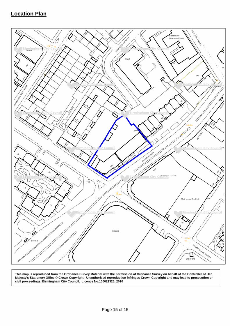
Page 15 of 15
Location Plan
This map is reproduced from the Ordnance Survey Material with the permission of Ordnance Survey on behalf of the Controller of Her Majesty's Stationery Office © Crown Copyright. Unauthorised reproduction infringes Crown Copyright and may lead to prosecution or civil proceedings. Birmingham City Council. Licence No.100021326, 2010
23BISHOPSGATE STREET
2628
25
24
22
5
9
145.7m
Works
Broa
dfie
ld W
alk
2
4
20
34
to 15
65 to
67
ROSV
ENO
R ST
REET
WES
T
44
PH57
202 201148.4m
Cumb
135
192
Grosvenor T
errace
138
95
195 to 198
199
194193
137
00 to 209
94
FB
PH
90
136
HEEPCOTE STREET
Shelters
17
Language CentreBrasshouse
7
100
Grosvenor Casino
BROAD STREET
185
19
Posts
9
ESSINGTON S
TREET
Hotel
1
Multi-storey Car Park
PH38
El Sub Sta
149.0m
150.6m
Cinema
12
10
Shelters
2
10
6
1015
The Square
18
TCB
1
Birmingham City Council
Planning Committee 16 January 2020 I submit for your consideration the attached reports for the North West team. Recommendation Report No. Application No / Location / Proposal Approve - Conditions 12 2019/07010/PA
65 Cheston Road Cheston Industrial Estate Birmingham Aston B7 5ED Change of use from warehouse and distribution (Use Class B8) to waste transfer station (Sui Generis), erection of new building, porta-cabin, waste bays and fencing
Approve - Conditions 13 2019/06615/PA
Plots 3 & 4 Advanced Manufacturing Hub Aston Hall Road Aston Birmingham B6 7TU Erection of commercial units for B1(c), B2 and/or B8 purposes together with associated servicing, parking, site access and landscaping
Page 1 of 1 Director, Inclusive Growth (Acting)

Page 1 of 12
Committee Date: 16/01/2020 Application Number: 2019/07010/PA
Accepted: 18/09/2019 Application Type: Full Planning
Target Date: 18/12/2019
Ward: Nechells
65 Cheston Road, Cheston Industrial Estate, Birmingham, Aston, B7 5ED
Change of use from warehouse and distribution (Use Class B8) to waste transfer station (Sui Generis), erection of new building, porta-cabin, waste bays and fencing Recommendation Approve subject to Conditions 1. Proposal 1.1. The application is for a change of use from a warehouse and distribution centre (Use
Class B8) to a waste transfer station (Sui Generis). The work to the site includes the proposed erection of a new building to contain two waste transfer bays, the siting of a porta-cabin and additional fencing on top of the existing boundary treatment.
1.2. The submission is for a non-hazardous waste transfer station for household, commercial and industrial wastes; storage of scrap metal for recycling; and end of life vehicle storage, depollution and dismantling. The applicant intends to use the existing building on site and erect new structures. One building is proposed which will be 3 sided with a roof and provide 2 waste transfer bays. It will measure 20m by 12m. One porta-cabin is also proposed, and the fencing is intended to be increased to 5.5m. The business is relocating from another site in Birmingham which is being compulsory purchased by HS2.
1.3. Supporting statements have been submitted with the application as follows: Planning Statement, Noise Management Plan, Air Quality Assessment, Transport Statement, Preliminary Ecological Appraisal and Illustrative Lighting Strategy. During the consideration of the application a Drainage Assessment and Dust and Emissions Management Plan have also been submitted.
1.4. An Environmental Impact Assessment Screening was carried out by the Council and a decision issued on the 14th June 2019 confirming that the proposal is not EIA development and that a planning application for the proposal would not require an Environmental Statement. The scheme falls under Schedule 2, 11b “Installations for the disposal of waste” of the Town and Country Planning (Environmental Impact Assessment) Regulations 2017. However, as the site is previously developed land, the disposal of the waste is not proposed by incineration or infill, will be less than 50,000 tonnes per year, is within an urban environment and of less than 10ha in area and the proposal is a relocation of an existing business the Council have screened the application as not requiring an Environmental Impact Assessment.
1.5. Link to Documents

Page 2 of 12
2. Site & Surroundings 2.1. The site is 0.94ha and lies within an existing industrial area with the Birmingham and
Fazeley canal immediately on its northern boundary and Cheston Road forming the southern boundary. The site has B8 consent and was previously a warehouse, however it was vacant for some time before being purchased by the applicant. The applicant has tidied the site ready for moving but has not started operating from the site.
2.2. Within the industrial area are a mix of uses including warehouses, metal fabrication, food warehouse, car repairs and MOT station, commercial retailers and other waste management sites.
2.3. Site Location 3. Planning History 3.1. 2005/00550/PA – Erection of 2.4m high vertical bar security fencing and gates to the
front of the site and to part of one side – Approved 19/04/2005
3.2. 1992/00110/PA – Alterations to front elevation and improvements to existing site access and car parking areas – Approved 21/01/1992
3.3. 1991/01687/PA – Minor elevation alterations, improvements to hardscape and new security fence – Approved 29/05/1991
4. Consultation/PP Responses 4.1. Adjoining occupiers, local councillors and local MP notified as well as site and press
notices displayed.
4.2. 5 objection letters have been received, from 3 local businesses, raising the following concerns:
• This use would be detrimental to the area where other businesses are improving the appearance and there has been inward investment
• Proposed use not compatible with the regeneration of Aston • Increased fencing height is unsightly, un-neighbourly, causes overshadowing
and creates a hostile feel to the area • Will impact on local environment and residential amenities • Existing area does not have noise outside usual business hours • Adjacent to food warehouse and close to cash and carry and food
establishments • Potential for rats/ vermin next to food warehouse • Increase in noise, air and light pollution • Potential for waste/ rubbish/ liquids to contaminate the canal and brook
running under the site • Increase in traffic • Insufficient highway capacity • Already congested area and high level of on-street parking • Impact on local bus routes and pedestrian safety • Increased need for repairs of services in roads

Page 3 of 12
• Area already overcrowded with similar companies and well served by these companies
4.3. Transportation Development – No objection subject to conditions to require highway
works to BCC specification, a limit on the annual throughput of waste, secure and covered cycle parking and parking spaces to be formally marked out on site and parking & vehicle circulation areas not to be used for any purpose (e.g. storage etc.)
4.4. LLFA – No objection as the site is located in an area of very low surface water flood risk and the proposal is for a change in use of an existing building (with minimal external works).
4.5. Regulatory Services – No comments received.
4.6. Environment Agency – No objections. Business will require an Environmental Permit which will cover, amongst other things, waste types, waste quantities and the processes. Will also require an Environmental Management System, Fire Prevention Plan and may require a dust and odour management plan. Expect the yard to have an impermeable surface with a sealed drainage system and no site run-off to discharge to the adjacent watercourse.
4.7. Canal and River Trust – No objections subject to conditions. Continue to raise concerns over the Air Quality Assessment and the impact on the canal and towpath. does not acknowledge the canal as a receptor. Works include construction of a new building and fence adjacent to the canal: request a construction methodology to ensure works do not affect the structural integrity of the canal or towpath. Welcome lighting design to avoid spill onto the canal and associated effect on wildlife: recommends condition to secure the lighting scheme as per the details submitted.
4.8. West Midland Police – No objections. Recommend Secured by Design, CCTV and intruder alarm systems.
4.9. West Midlands Fire Service – Provided standard advice regarding access and firefighting facilities. Noted the inclusion of sprinklers in this design proposal.
4.10. Employment Team – Request condition to secure local employment provision. 5. Policy Context 5.1. The following policies are applicable:
• Birmingham Development Plan 2017 • Birmingham Unitary Development Plan (saved polices) • Car Parking Guidelines SPD • Places for All SPD • Revised National Planning Policy Framework 2019 • National Planning Policy for Waste 2014
6. Planning Considerations 6.1. Policy PG1 of the BDP sets out the overall levels of growth for Birmingham and
includes the need for new waste facilities to increase recycling and disposal capacity and minimise the amount of waste sent directly to landfill. Policy TP13 – sustainable

Page 4 of 12
management of the City’s waste seeks to manage Birmingham’s waste in the waste hierarchy. The key objectives are to minimise the amount of waste created, treat waste as a resource and encourage recycling, reuse and composting. The Policy seeks to ensure that the tonnage of waste treated and managed within Birmingham is equivalent to the tonnage of waste arising, it notes that there is currently a shortfall in the number of material recycling facilities within the City and more will need to be constructed during the plan period.
6.2. The supporting text of TP13 notes that a significant part of reducing waste is the removal of biodegradable and recyclable materials prior to waste being landfilled and reiterates that there is a need to increase disposal capacity to deal with commercial and industrial waste to reduce what is sent to landfill.
6.3. TP14 is the policy relating to new and existing waste facilities. This policy supports the expansion of existing facilities and the development of new waste management facilities. TP14 continues the support for reducing waste to landfill and also seeks to protect existing waste management facilities providing they do not have a negative impact on the environment and amenities.
6.4. Policy TP15 sets out location criteria for waste management facilities. The criteria includes, as areas considered appropriate for waste management facilities, industrial areas (including Core Employment Areas) and sites adjacent to existing waste management facilities. Any new facility will also need to consider the environment, neighbouring land uses, traffic, pollution control measures, residential amenity and design. The supporting text advises that where a new facility demonstrates it is sustainably located it will be supported and that modern, well-run, facilities may present no more noise or loss of amenity than a typical industrial use. These facilities are essential to managing waste in a sustainable and efficient way.
6.5. The National Planning Policy for Waste (NPPW) is also relevant to the proposal. This policy, which is a material consideration, promotes the ‘waste hierarchy’, a strategy setting the priority for prevention of waste and diversion away from disposal. The application for a waste transfer station will enable more material to be recycled and reused and as such complies with the NPPW aims. Any hazardous waste will be stored on site for transfer off site via a suitable contractor. The only potentially hazardous waste identified is as part of the disposal of vehicles.
6.6. The principle of the proposed relocation of the existing waste transfer station from its current site to a new site is supported in local policy. The business is not able to stay on its current site and as such relocation is required. The loss of the business would reduce the capacity of waste management facilities in the City and as such relocation should be supported. The proposed site is within an industrial area and is therefore considered appropriate against policy TP15. The key issues are whether the proposed site is appropriate in terms of impact on amenity, traffic, pollution and design.
6.7. The submitted planning statement advises that the site will handle up to 35,000T of waste per annum. Within this total annual throughput approximately 5,200T will be general waste (builders waste/ skip waste), 20,000T will be scrap cars (approx. 200-300 per week) and 5,200T will be clean scrap. The agent has acknowledged that these breakdown figures do not add up to the total throughput, they are intended as a guide to the percentage split between different waste types. The site will employ 20 FTE staff, mainly transferred from their existing site, and predict 10 FTE new staff over the next 18 months. The proposal is to “lift and shift” the existing business to the application site. They already handle all of the types of waste proposed to be
Page 5 of 12
handled at the application site. I acknowledge that the exact figures of what level of what type of waste is to be handled is unknown, however the key figure is the annual throughput. Proposed buildings/ structures
6.8. The existing building is to be retained and reused to provide offices, vehicle storage and non-ferrous metal storage. Within the existing hard standing the proposal is to site one portacabin; construct a building to provide 2 waste transfer bays; site a baler, 3 vehicle weighbridges, vehicle racking, tyre and skip storage areas; and provide areas for parking and manoeuvring.
6.9. The porta-cabin is 6.1m by 3.4m with a flat roof at 2.6m high. This is a structure that will be brought onto site and positioned on existing hard standing. As the structure is to be sited within the application site, behind the proposed fencing and near to the existing building I consider that this structure will clearly be read as ancillary to the main building and is appropriate in scale and design for the site and its intended use.
6.10. The waste bay structure is open fronted with three walls constructed of concrete panels with cladding above. It will measure 20m by 12m. The roof has a shallow pitch at 4.55m to eaves and 6.2m to the ridge. This structure is to be sited behind the existing building and adjacent to the high brick wall on the boundary. The structure will not be visible from outside the site. I consider its design and scale is also appropriate for the site, the wider area and the proposed use.
6.11. The weighbridges are within the hard surfacing and have limited above ground features. The skip storage area is proposed along the wall with the canal and, providing the skips are not stacked above the height of the wall there will not be any visual harm from this part of the development. The impact of the vehicle racking will also depend on the height of the structure. Providing the storage of both skips and vehicles is no higher than the proposed boundary fence the impact will be minimal. I have therefore recommended a condition restricting external storage to 5m and therefore 0.5m below the height of the proposed fence.
6.12. Overall, I consider that the siting, scale and design of the proposed structures and equipment on site is appropriate for this industrial location and in context with the surrounding built form. Boundary treatment
6.13. The proposal includes the erection of additional fencing on top of the existing boundary treatments (which is in part retention of work already carried out on site) to increase the height of the existing sheet metal fencing on Cheston Road by about 2m to a total of 5.5m high (4.5m fence above 1m wall), and to increase the fence on the edge to the canal, where it is proposed to add a 2m fence to the existing high wall and 4.5m fence above the low wall (again, approximately 5.5m total height).
6.14. My City Design advisor has noted that the fencing would form a blank, inactive and highly visible frontage to Cheston Road and the canal. This would block and detract from views along the road and canal. However, given the existing mix of building types and boundary materials used at the site and within the industrial estate generally, it is considered that this would not be a significant change to the appearance of the site and is acceptable in principle.
6.15. It is suggested that the visual impact of the fencing could be mitigated by breaking it up, for example with darker vertical elements similar to the cladding of existing

Page 6 of 12
industrial units on the opposite side of Cheston Road, or more imaginative treatment and that this could be achieved through a suitably worded condition. Highway impact and vehicle movements
6.16. A Transport Statement has been submitted with the application which advises that the site is within area 2 as defined in the adopted Car Parking SPD. It is 1km from Aston train station, close to bus stops and with access to the canal 400m from the site. 10 car parking spaces are proposed on site along with cycle parking provision for 6 bicycles. The layout has been designed to enable vehicles to enter, manoeuvre and leave in a forward gear.
6.17. The submitted Planning Statement notes that the site predicts 140 movements per day which will be greater than the potential vehicle movements for the extant B8 use of the site (TRICs potential trip rates of 76 two way movements). The TS advises that this will be made up of 60 LGVs, 5 HGVs and 3-6 skip lorries (70 vehicles, 140 two way movements). The movements are spread across the day between 6am and 7pm with the majority of movements between 8am and 5pm. The proposed use will increase daily vehicle movements above what is predicted for a B8 use on the site. However, the Transport Statement submitted with the application concludes that the overall increase on the local road network is not significant and would not result in a severe impact on highway safety.
6.18. As noted above the site is in a sustainable location where staff could be encouraged to travel by sustainable means. Accident data has also been considered and this show 11 collisions within 500m of the site. All were on the main roads around the site, none on Cheston Road.
6.19. Within the objection concerns are raised about the potential increase in traffic, the impact on underground services, bus routes and pedestrian safety.
6.20. Initially Transportation requested additional information. This information has been received and forwarded to Transportation who have confirmed that they have no objection subject to conditions. I concur with this view and agree the conditions are reasonable and appropriate. Impact on local amenity
6.21. The local representations received have also commented that the use will adversely affect residential amenity, increase noise, air and light pollution and that the existing businesses do not cause noise after general business hours. Furthermore the objectors consider that the fencing will cause overshadowing, that the use will affect the adjacent food warehouse and cause the potential for rats (and other vermin) and potentially contaminate the canal.
6.22. As noted by an objector the applicant proposes hours of operation between 7am and 7pm with processing and sorting only during these hours but requests the ability to receive waste 24 hours a day.
6.23. The application has been submitted with a noise assessment which confirms the applicant is aware of the need for an EA permit which will require them to comply with Best Available Techniques including avoiding noise emissions. The noise assessment identifies potential sources of noise including metal processing, use of forklift trucks and general movement of waste. The report acknowledges the proximity of the canal but suggests that the impact will be low as this stretch of the canal does not provide areas for waiting and there are other significant industrial noise sources in the area.

Page 7 of 12
6.24. The existing building is brick and steel with the roof internally lined. As such, subject
to retaining the doors closed during the nosiest of operations, the building will further reduce the potential for noise. All plant and machinery on site is regularly tested and maintained and vehicles are fitted with white noise reversing alarms. Staff are all trained, noise is monitored and recorded and the proposed fencing/ walls around the site will help screen the noise from the surrounding area.
6.25. An Air Quality Assessment has also been submitted with the application which acknowledges the potential for dust and vehicle emissions. However, the assessment concludes that, due to the separation distance to residential properties, the proposed site mitigation measures and metrological conditions the impact would not be severe. The air quality impact from vehicle movements is predicted to be negligible and not significantly greater than the background levels.
6.26. The AQA was updated following initial comments from the Canal and River Trust to consider potential impact on the canal and towpath users. 3 locations along the canal and 3 on the canal were considered. Overall the sensitivity of the receptors was assessed to be low and the impact negligible due to the transient nature.
6.27. A Dust and Emissions Management Plan was submitted during the consideration of the application. This document provides detailed advice on the management of dust and emissions during the operation of the site as a waste transfer station and sets out procedures for managing dust. The report notes that there are a number of sensitive receptors within 1km (including public houses, hotels, schools, church, mosque, health centres, police station offices, restaurants, takeaways and other businesses) but that all, except one, would not be affected by dust from the site due to prevailing wind direction or intervening structures and landscaping. Aston Manor Brewery is downwind and in close proximity to the site but the impact can be minimised by the proposed increase in the fence height and the dust management procedures.
6.28. The nearest residential property is over 150m from the application site. The use of the site as proposed would not have any impact on any residential amenity. Neither would the increase in height of the fence cause any overshadowing. The businesses to either side of the site and on the opposite side of the canal do not have any buildings with windows on elevations adjacent to or facing the proposed fencing. The business on the opposite side of Cheston Road is approximately 12m from the proposed fence and lies to the south. As such the separation distance is sufficient to maintain natural light to the business opposite which causes shadow to its own windows due to its orientation.
6.29. In addition the site will be operated under an EA permit. This is separate regulations which deal with the management and operation of the site to ensure that it does not cause any environmental harm. The site will be managed by suitably qualified and certified staff with regular monitoring and maintenance. The waste bays will be emptied at least every 48 hours (and disposed off-site), the site will be cleaned daily, potentially hazardous liquids from vehicle depollution will be drained to a sealed storage tank for disposal off-site, waste can be dampened if required and the site drainage system is to be fitted with an oil interceptor. There is no reason why the proposed use, which does not include storage of food or food waste, would cause any greater attraction to rats or vermin than any other industrial use on this site. The management of the site, under the EA permit, will minimise any risk to the surrounding area.
Page 8 of 12
6.30. Neither CRT nor the Environment Agency have raised any objections to the proposal, and I agree with their recommendations and conclusions.
6.31. The comments of the objector regarding the different hours of other businesses and the proposed use is not a comment which I can back-up with planning evidence. Taroni’s of Birmingham, which is a separate company to the applicant’s company, but a similar operation, are located nearby. The planning consent for that site dates back to 1987 and limits the site from being open to the public, receiving deliveries or dispatching material, between the hours of 7am and 8pm. As such the proposal on the application site, for 7am to 7pm opening hours, but with the ability to receive urgent deliveries out of these hours, would not be dissimilar to the consent for nearby premises operating a similar use.
6.32. Other businesses within the same industrial area have varied hours of operation restrictions or none at all. There are businesses within the area which could operate 24 hours a day without further planning permission. In conclusion the use of the site at 65 Cheston Road will not have an adverse impact on any residential properties or the amenities of the canal. The site is within an industrial area with a mix of uses, including similar uses and the business is relocating from a site less than 1km away. As such it is unlikely that the proposed change of use would have any greater impact.
Other matters
6.33. Drainage – The submitted drainage assessment has considered the feasibility of Sustainable Urban Drainage systems (SUDs). The site is currently 100% impermeable and will remain as such, furthermore there is a risk of contamination from the proposed use. Accordingly the scheme does not propose infiltration. The runoff from the existing building discharges to Hockley Brook and it is intended to retain this. The new building and portacabin will be fitted with new drainage systems discharging via attenuation to Hockley Brook. The surface water from the yard area will be discharged to the mains foul drainage system as this is required by the EA for waste transfer sites. An oil interceptor will be fitted to reduce the risk of contamination.
6.34. The LLFA requested additional information which has been received and forwarded to the LLFA. The LLFA have confirmed that they have no objection to the proposal.
6.35. Ecological impact – The site is adjacent to the Birmingham and Fazeley canal which is designated as a Site for Local Nature Conservation (SLINC). A Preliminary Ecological Appraisal has been submitted which confirmed the consultant carried out a desk top study, habitat assessment and bat roost assessment. The existing buildings have low suitability for bats and birds with no evidence of bats roosting. The site has limited potential for bats foraging or commuting. There was no evidence of any protected species, but the report recommends precautionary measures for nesting birds and a sensitive lighting scheme to minimise impact on bats.
6.36. The submitted lighting scheme shows diagrams and figures detailing the illuminance levels within and around the site. The details show that, with the additional height on the fence and the lighting being installed on the inside of the fence, there will be no spillage beyond the site.
6.37. The Council Ecologist has advised that due to the nature of the site it has negligible ecological potential. The canal is used for commuting bats but the lighting strategy
Page 9 of 12
mitigates some of the potential light spill. As such a condition is recommended to ensure that the lighting is installed as per the submitted lighting strategy.
6.38. Crime – West Midlands Police have raised no objection recommending conditions (as detailed in section 4 above). I note the comments of the local representation, however these are matters for the police and not matters which can be considered as part of a planning application. The application relates to the use of the site as a waste transfer station.
6.39. Need – A local representation has also objected on the grounds that there are already similar uses in the area and as such the Council should be encouraging the applicant to relocate to another area. This is an objection on the basis of competition which is not a material planning consideration. TP13-TP15 advise that there is a general need for waste transfer sites across Birmingham to help with reducing landfill. The policy promotes sites on industrial estates and there is no policy requirement to prove a need either generally or for a specific location.
7. Conclusion 7.1. For the reasons given within this report I consider that the proposed change of use
of the site at 65 Cheston Road to a waste transfer station complies with the adopted policies in the BDP and the guidelines within the NPPF, NPPW and the Council’s SPDs. The scheme will not have a detrimental impact on the character of the area, the amenities of neighbouring land uses, highway safety, drainage or ecology.
8. Recommendation 8.1. That planning permission is approved, subject to the following conditions: 1 Requires the scheme to be in accordance with the listed approved plans
2 Requires the submission of a lighting scheme
3 Requires the submission of a CCTV scheme
4 Requires construction method statement
5 Prevents use until the turning and parking area has been constructed
6 Limits the maximum external storage height to 5 metres
7 Requires the submission and completion of works for the S278/TRO Agreement
8 Requires the submission of cycle storage details
9 Implement within 3 years (Full) Case Officer: Karen Townend
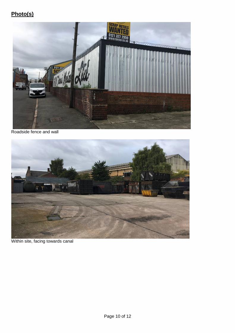
Page 10 of 12
Photo(s)
Roadside fence and wall
Within site, facing towards canal
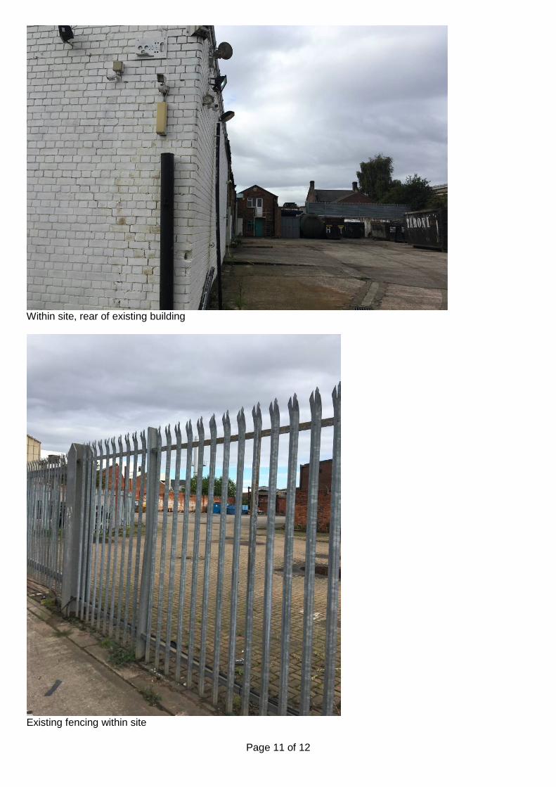
Page 11 of 12
Within site, rear of existing building
Existing fencing within site

Page 12 of 12
Location Plan
This map is reproduced from the Ordnance Survey Material with the permission of Ordnance Survey on behalf of the Controller of Her Majesty's Stationery Office © Crown Copyright. Unauthorised reproduction infringes Crown Copyright and may lead to prosecution or civil proceedings. Birmingham City Council. Licence No.100021326, 2010

Page 1 of 14
Committee Date: 16/01/2020 Application Number: 2019/06615/PA
Accepted: 06/08/2019 Application Type: Full Planning
Target Date: 17/01/2020
Ward: Nechells
Plots 3 & 4, Advanced Manufacturing Hub, Aston Hall Road, Aston, Birmingham, B6 7TU
Erection of commercial units for B1(c), B2 and/or B8 purposes together with associated servicing, parking, site access and landscaping Recommendation Approve subject to Conditions 1. Proposal 1.1. The scheme as originally submitted proposed the erection of 19 commercial units in
4 buildings. During the consideration of the application the scheme was amended (to improve the layout of Block B) which resulted in the reduction of the number of units to 18, with a total footprint of 6,444sqm (and total floorspace with mezzanines of 8,559sqm).
1.2. Block A is to be 5 units (1,374sqm), Block B is amended to 2 units (435sqm), Block C is 6 units (1,867sqm) and Block D is 5 units (2,768sqm). The buildings, and therefore units, are being built speculatively by a development company. The application seeks consent for the uses to include B1(c) (light industrial), B2 (general industrial) and B8 (storage and distribution) uses and also for the potential for interior mezzanine floors. However the internal layouts of the units are shown for indicative purposes only, the finished internal layout will be for the end user to provide.
1.3. The buildings are all rectangular in footprint with Blocks A and D having small cut out sections where the road curves around the site. Blocks A, C and D will all have shallow pitched roofs. The submitted plans show heights of approximately 9.8m to eaves and 11.3m to ridge. The amended version of Block B has a hipped roof and is 8.3m to ridge (7.8m to eaves). The cross sections of the site show that to achieve a level site the ground will need to be raised approximately 0.8m where the site is adjacent to Aston Hall Road at the north. There are no ground level changes proposed along Waterworks Street.
1.4. Within the application site 121 parking spaces are proposed of which 18 are disabled spaces. The submitted planning statement proposes 24% of the spaces are provided with EV charging points (29 spaces). Cycle storage is proposed within the units. The application site will also provide access and manoeuvring space for HGVs and LGVs but no on-site parking for larger vehicles. Additional landscaping is also proposed around the site boundaries and within the parking areas.
1.5. The application has been submitted with the following supporting documents: Planning Statement, Design and Access Statement, BREEAM Pre Assessment, Construction Management Plan, Energy and Sustainability Statement, Flood Risk
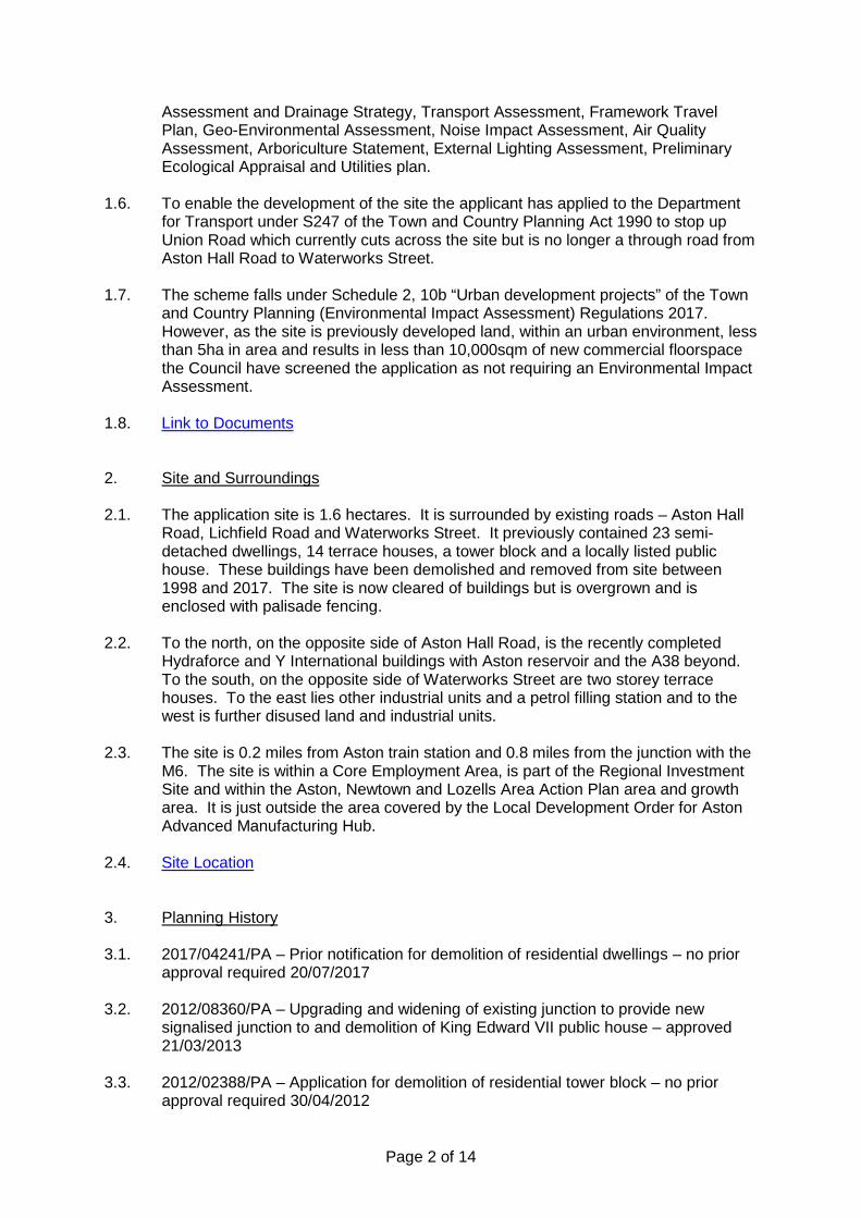
Page 2 of 14
Assessment and Drainage Strategy, Transport Assessment, Framework Travel Plan, Geo-Environmental Assessment, Noise Impact Assessment, Air Quality Assessment, Arboriculture Statement, External Lighting Assessment, Preliminary Ecological Appraisal and Utilities plan.
1.6. To enable the development of the site the applicant has applied to the Department for Transport under S247 of the Town and Country Planning Act 1990 to stop up Union Road which currently cuts across the site but is no longer a through road from Aston Hall Road to Waterworks Street.
1.7. The scheme falls under Schedule 2, 10b “Urban development projects” of the Town and Country Planning (Environmental Impact Assessment) Regulations 2017. However, as the site is previously developed land, within an urban environment, less than 5ha in area and results in less than 10,000sqm of new commercial floorspace the Council have screened the application as not requiring an Environmental Impact Assessment.
1.8. Link to Documents 2. Site and Surroundings
2.1. The application site is 1.6 hectares. It is surrounded by existing roads – Aston Hall
Road, Lichfield Road and Waterworks Street. It previously contained 23 semi-detached dwellings, 14 terrace houses, a tower block and a locally listed public house. These buildings have been demolished and removed from site between 1998 and 2017. The site is now cleared of buildings but is overgrown and is enclosed with palisade fencing.
2.2. To the north, on the opposite side of Aston Hall Road, is the recently completed Hydraforce and Y International buildings with Aston reservoir and the A38 beyond. To the south, on the opposite side of Waterworks Street are two storey terrace houses. To the east lies other industrial units and a petrol filling station and to the west is further disused land and industrial units.
2.3. The site is 0.2 miles from Aston train station and 0.8 miles from the junction with the M6. The site is within a Core Employment Area, is part of the Regional Investment Site and within the Aston, Newtown and Lozells Area Action Plan area and growth area. It is just outside the area covered by the Local Development Order for Aston Advanced Manufacturing Hub.
2.4. Site Location
3. Planning History 3.1. 2017/04241/PA – Prior notification for demolition of residential dwellings – no prior
approval required 20/07/2017
3.2. 2012/08360/PA – Upgrading and widening of existing junction to provide new signalised junction to and demolition of King Edward VII public house – approved 21/03/2013
3.3. 2012/02388/PA – Application for demolition of residential tower block – no prior approval required 30/04/2012

Page 3 of 14
3.4. 2011/04584/PA – Demolition of terrace of 14 derelict houses – no prior approval
required 30/09/2011
3.5. 2006/04074/PA – Demolition of the residential tower block – approve subject to conditions 19/07/2006
4. Consultation/PP Responses 4.1. Adjoining occupiers, local councillors and local MP notified as well as site and press
notices displayed.
4.2. 2 objection letters have been received raising the following concerns: • Do not want/ need anymore warehouses/ industrial units • These units do not bring jobs • Would prefer a corner shop, post office, chemist etc • Increase of pollution • Insufficient parking on site results in parking on local roads • On-street parking already used by businesses and during match days • Potential for disturbance from night working/ traffic
4.3. Transportation – No objection subject to amendments/ conditions. The traffic
to/from the proposed development would unlikely to have severe impact on surrounding highways. The level of parking provision is considered to be acceptable. Recommends the Travel Plan be agreed through the STARS portal. Requested confirmation of location of cycle parking, recommended the footway be provided on both sides of the access road and that the car parking areas are enclosed so that cars don’t block the footways. A commuted sum for maintenance may be required if footways outside the site are to be adopted by the Council. Depending on the location of highway lighting columns, these might require some lighting also. Furthermore, the development proposal leads to extinguishment of Union Rd, which would need to be progressed by applying a s247 stopping-up resolution under the Town and Country Planning Act.
4.4. Environment Agency – No objections. Recommends a condition to deal with
unexpected contamination during development and provided advice for the applicant in regard to contamination and excavated materials.
4.5. LLFA – Requested additional information.
4.6. Severn Trent Water – No objections subject to conditions requiring details of foul and surface water drainage and subsequent implementation of such. There are public sewers and clean water apparatus near the site and the developer should contact STW prior to development to discuss implications.
4.7. Regulatory Services – No comments received.
4.8. West Midland Police – Recommends Secured by Design standards, a site wide CCTV scheme and that individual units also have separate CCTV (recommends a condition), also recommends on-site security, supports the use of 2m paladin

Page 4 of 14
fencing and gates but raises concerns about relying on the tenants to open/ secure the gates.
4.9. West Midlands Fire Service – Water supplies should be provided for firefighting, access roads should have a minimum width of 3.7m between kerbs and any dead end greater than 20m in length should have an appropriate turning facility for a pump appliance.
4.10. Canal and River Trust – It is possible to access the towpath at Cuckoo Road to the north and Holborn Hill to the south and the submitted framework travel plan identifies routes along the canal. Details should therefore be included of the proximity of the canal and the potential for use by staff. Recommends a condition to secure this included into the travel plans. Also requested installation of signage.
4.11. Employment Team – Requested S106 or conditions to secure local employment during construction and post completion.
5. Policy Context 5.1. The following policies are applicable:
• Birmingham Development Plan 2017 • Birmingham Unitary Development Plan (saved polices) • Car Parking Guidelines SPD • Places for All SPD • Aston, Newtown & Lozells Area Actin Plan • Aston Advanced Manufacturing Hub Development Framework (July 2016) • Revised National Planning Policy Framework 2019
6. Planning Considerations
Policy and principle of development 6.1. The purpose of the planning system is to promote sustainable development (NPPF
paragraph 7). Section 6 of the NPPF “Building a strong, competitive economy” seeks to help create the conditions where business can invest, expand and adapt and places significant weight on economic growth. Paragraphs 117 and 118 require effective use of land and aim to make as much use as possible of previously developed land (brownfield sites) giving the re-use of these sites substantial weight.
6.2. PG3 of the Birmingham Development Plan (BDP) sets overall growth targets for Birmingham which include a target for ensuring a supply of available employment land in order to provide employment for the City’s growing population and reduce unemployment. This is further supported in TP17. The policy for the Regional Investment Sites (Longbridge and East Aston) is TP18. These sites have been allocated to support the City’s economy and deliver large, high quality, investment sites. The policy advises that uses within the Regional Investment Sites will be restricted to B1 and B2. B8 uses will only be permitted where it is ancillary to the main B1 and B2 use. Policy TP19 protects core employment areas for employment use (B1, B2 and B8).
6.3. The application site is within the Aston, Newtown and Lozells Area Action Plan (AAP). The document is a material consideration. It sets the vision and strategy for regeneration and development in the area with a view to maintaining a supply of
Page 5 of 14
employment land and also create sustainable neighbourhoods. The AAP notes that there are opportunities for housing regeneration, to enhance the environment, protect green spaces and create jobs. It sets a target of 1,700 new homes and 5,160 new jobs, of which 3,000 will be in the 20ha Regional Investment Site.
6.4. The site is also at the eastern gateway to the Aston Advanced Manufacturing Hub (AMH). The Aston Advanced Manufacturing Hub Development Framework was adopted by the City Council as guidance to attract investment and create an attractive business environment, including promoting high quality design and place making. It therefore supports the aims of both the BDP and the NPPF. The framework sets principles for the whole of the AMH which include (amongst other matters) providing for pedestrian movement, marking key junctions, screening service area from the public realm, providing landscaping where the site is adjacent to housing and setting security fencing back within landscaping.
6.5. The application site is identified as Area B (Lichfield Road) in the AMH Framework and notes that the development will face houses on the opposite side of Waterworks Street and identifies that this edge will be sensitive. The site is noted as a key junction with the potential to accommodate two plots in a prominent location. The proximity of the houses on the opposite side of Waterworks Street mean that the site is most appropriate for B1 use and ancillary/ supporting uses such as a hotel and/or retail uses.
6.6. The guidance for this specific area sought: • Provide a landmark building at Lichfield Road/ Aston Hall Road junction, with
sufficient height and architectural quality to mark this prominent location; • Building form and/or landscaping at southwest corner should provide an
attractive focus for views along Aston Hall Road; • Buildings are to have active frontages to Lichfield Road and Aston Hall Road.
Retain significant existing trees where possible; • Buildings on the Waterworks Street edge fronting and overlooking the street
are encouraged (3 storeys maximum facing existing houses). A less active but well landscaped edge may be acceptable
6.7. The submitted Design and Access Statement advises that the proposal will provide
starter units for small to medium businesses to complement the existing larger employment premises within the Advanced Manufacturing Hub. The scheme provides 4 buildings which internally will be subdivided to provide 18 units. The unit floor spaces range in size from 312sqm to 886sqm, including mezzanine floors (220sqm to 678sqm ground floor only).
6.8. The principle of new industrial units on this site is acceptable and supported by local and national policy. I consider that the proposed development will provide a variety of small units, which could be combined to make bigger units but nevertheless are smaller than the majority of the other units being provided on the RIS, AMH and within the AAP area.
6.9. B8 uses are not specifically noted as uses supported in policy TP18 or the guidance within AMH Framework. The Council would not support site wide B8 use or any of the larger units across the wider RIS to be for wholly B8 use. However, I consider that B8 is likely to be ancillary to B1 and B2 uses and the units are small enough to restrict the impact of B8 use on the site. To ensure that, through amalgamation of the smaller units, the B8 uses on the site do not turn into the dominant use on the site I suggest that a condition should be imposed. The condition would need to
Page 6 of 14
restrict amalgamation and the use being B8. Amalgamation and B1 or B2 uses would be acceptable, but I would seek to restrict B8 uses in any unit larger than those currently proposed.
Layout, scale and appearance of proposed buildings
6.10. As noted above the design and layout of the scheme has been amended since submission. The amendments were sought following initial advice from City Design and Landscape Officers as the scheme was not considered to be acceptable and did not meet the requirements of the AMH Framework or PG3 of the BDP.
6.11. The main revisions to the plans are the position of Block B, the inclusion of additional landscaping and the addition of a footpath link to Waterworks Street (though this will only be for staff of the site rather than a through route). The four blocks are laid out around an internal access road and parking area. Block A sits to the west of the access into the site parallel with Aston Hall Road, Block B is the opposite side of the access into the site and lies at a 90 degree angle to Aston Hall Road. Block C runs with its rear elevation along Lichfield Road and Block B with its rear elevation parallel to Waterworks Street. The proposed layout provides access off Aston Hall Road, with sufficient distance from the existing junctions, an estate road within the site, parking along the frontages of the buildings and landscaping all around the outside edge of the site.
6.12. The buildings face into the site, however the amended plans have included high level windows on Lichfield Road and Aston Hall Road and two different profiles of Merlin grey cladding which both add interest to these elevations. As noted above landscaping is also proposed around the edges of the site which will also soften the appearance of the buildings and add interest from the surrounding area.
6.13. Within the Planning Statement the agent considers that the design and materials are contemporary. The buildings are designed as generic industrial units, built with no end users identified. This has meant that the buildings have no special character or features, however it does result in a small industrial estate with a consistent design and appearance. This set of four blocks will not only provide small units for smaller businesses but is also designed as an estate. I consider that the layout, scale and appearance, as amended, is now acceptable and complies with the Council’s policies and the NPPF.
6.14. The site is to be enclosed with paladin fencing and the vehicle and pedestrian accesses gated for security. The fencing will be positioned between the road and the buildings, set behind the landscape buffer. The fencing of a similar design and finish to the fencing around Hydraforce and Y International and as such is considered to be appropriate in the context of the surrounding employment uses. Siting the fencing inside the landscaping is also supported as this reduces the visual impact of the fence. Impact on surrounding area and residents
6.15. The layout of the site proposes the buildings around the outside edge with the parking and manoeuvring space in between. In addition landscaping is proposed between the buildings and the roads, on the outside edge of the proposed security fencing. The agent considers that both the buildings and the landscaping will act as a buffer for the residential properties on Waterworks Street.
6.16. A Noise Assessment has been submitted with the application which details the baseline surveys carried out and predicts noise levels for end users. The conclusion of the assessment is that no adverse effects are expected. The report

Page 7 of 14
acknowledges that there are residential properties on Waterworks Street approximately 40m from boundary of site but predicts that the noise levels from HGV movements and plant within the site will be below the background levels at the nearest residential dwelling. The dominant background noise is from existing industrial premises and road traffic but the assessment advises that the proposed development will not substantially add to the background noise levels.
6.17. There is a potential for noise during construction works but this will be short term. The finished development will be inward facing with landscaping between the buildings and the residential properties. Vibration impacts have also been scoped out due to proposed end uses.
6.18. With regard to air quality the submission acknowledges that the site is in an area where NO2 is already above target guideline levels (though PM10 is within objectives). However, the submission predicts that the development will not increase NO2 or PM10 by a detectable amount and as such considers therefore that the impact will be negligible.
6.19. Lighting details have also been provided showing external lighting for the proposed development. The lights are proposed within the site, on the car park facing elevations of the building. They will be fitted with timelocks so as to only be operational during the hours the businesses are operational. The design is intended to reduce sky glow and light spillage beyond the site.
6.20. Regulatory Services have been consulted on the application but have not provided any comments. Should an update be available members will be advised at the committee meeting. However, given the information provided by the applicant I do not consider that the development will result in adverse impacts on the amenities of the neighbouring residents. Conditions can be imposed to ensure that any plant or machinery is installed on the inward facing elevations of the buildings, or that noise assessments are carried out. Highway impact, access and parking
6.21. Vehicular access is proposed off Aston Hall Road. A separate pedestrian access is also proposed off Waterworks Street though this will only be available for use by employees of the estate to ensure that the site is secure. The access into the site is provided centrally on Aston Hall Road with sufficient visibility in both directions. The internal estate road provides access to the frontage and parking areas for each unit and also provides space for turning. As noted above parking is provided to the front of each unit and also a parking area between Blocks C and D.
6.22. Footways are provided within the site and also to cut the two landscaped corners, where Aston Hall Road joins Lichfield Road and where Waterworks Street joins Aston Hall Road (though this is a pedestrian only join). The surrounding roads are already served with footways.
6.23. A Transport Assessment has been submitted with the application which has assessed the predicted trip generation for the proposed development (as originally submitted) with a use split of 11% B1a, 3% B1b, 35% B1c, 32% B2 and 19% B8. The split has been estimated based on the applicant’s existing similar business premises and shows that the majority of the site will be in B1 use. The predicted trip rates are 55 light vehicle movements in the am peak and 39 in the pm peak and 4 HGV movements in the am peak and 2 in the pm peak. As such there is an increase in vehicle movements above the previous residential and public house traffic.

Page 8 of 14
6.24. The layout of the site has been designed with space for HGV deliveries but with no
HGV parking/ waiting areas. the internal layout provides for HGV manoeuvring. However, the predicted HGV movements are low, the units are all small and as such the number of HGVs visiting the premises should be limited. It will also be for the overall management of the site, which will remain under one management, to ensure that HGV parking does not become an issue either on the estate or within the surrounding area.
6.25. 121 car parking spaces are proposed within the site. The site is located within area 2 as defined in the Car Parking SPD where the maximum is for 1 space per 45sqm of B1 use and 1 space per 90sqm for B2 and B8 uses. If the whole site was used for B1 use this would equate to a maximum of 191 spaces and as such the proposal for 121 spaces is suitable for the proposed mixed use site. 19 disabled spaces are proposed and one dual electric vehicle charging point is proposed per unit which equates to 28 spaces. Both the provision of disabled spaces and EV charging points are positive and comply with the requirements of the SPD and the Council’s target for reducing carbon.
6.26. Cycle parking is proposed within the units and as such is not shown at this stage. However, the agent has advised that the development could provide 24 cycle spaces which would be above the minimum required in the SPD of 1 space per 400sqm.
6.27. A Framework Travel Plan has been submitted which aims to promote sustainable travel and access by walking and cycling. At this stage this document is an outline framework and the end users of the units will need to provide detailed travel plans for each use. The FTP aims to achieve 10% modal shift from single occupancy vehicle travel to sustainable modes. It recommends the appointment of a Travel Plan Co-ordinator, marketing, information notice boards and regular monitoring and review of the travel plans.
6.28. A Construction Management Plan has also been submitted with the application which advises that construction traffic will access the site from Aston Hall Road, all construction parking will be within the site, the site to be covered with hardcore at the beginning of works, deliveries be timetabled to avoid peak hours and measures provided to reduce dust and dirt.
6.29. My Transportation Officer initially queried the location of the cycle parking. In response the agent commented that cycle parking will be provided within the unit by the end user. My Transportation Officer continues to raise concerns about this as the space could be used for other uses and recommends that a condition is imposed to require the provision and maintenance of cycle parking at the site.
6.30. Noting the comments from the objectors Transportation Development have no objections on all other highway, access and parking matters. They advise that traffic to/from the proposed development would unlikely to have severe impact on surrounding highways and the level of parking provision is considered to be acceptable.
6.31. With regard to the stopping up of Union Road, this will need to be carried out under S247 of the Town and Country Planning Act 1990. An assessment has been carried out on the use of Union Road since the demolition of the houses. The road has been used infrequently and as such the applicant considers its closure would not impact on the wider road network. I concur with this view and consider that the
Page 9 of 14
closure of Union Road is required to enable the development of the site for employment uses. As such the recommendation to members includes advising that no objection be raised to the stopping-up of Union Road Lane and that the Department for Transport (DFT) be requested to make an Order in accordance with the provisions of Section 247 of the Town and Country Planning Act 1990. Drainage and sustainability
6.32. Due to the size of the site a Flood Risk Assessment (FRA) has been submitted with the application. The northern part of the site is within flood zone 2 associated with River Tame but the FRA considers that the site has low risk of surface water flooding, low to medium risk of groundwater flooding, low risk of sewer flooding and limited risk of canal flooding. There is a risk of reservoir flooding (from Aston reservoir) but this is low due to it being a maintained structure.
6.33. The site is not functional flood plain and as such the development will not displace flood levels. Furthermore, the site is allocated within the Council’s adopted policies for industrial use which are “less vulnerable” uses than the previous residential use on the site. The Council have carried out a Strategic FRA and confirmed that the principle of industrial development on this site is acceptable in flood risk terms.
6.34. Surface water drainage for the site is proposed to be discharged to the existing sewer system. Foul drainage is also to be discharged to mains. Additional drainage information was sought during the determination of the application and has been forward to the LLFA. Comments are awaited and members will be updated at the committee meeting.
6.35. The scheme proposes the use of solar PV panels, energy efficient lighting, high efficiency boilers, low water use sanitary ware, use of natural light and solar gain. The construction of the buildings will also seek to use materials that are responsibly sourced.
6.36. Green roofs have been discounted as ground level landscaping will provide greater biodiversity enhancements and the use of green roofs also impacts on potential for rooflights and requires increased steel frame loading which has an associated carbon impact. CHP has also been discounted as there are no existing systems in the area to which a connection could be made and the installation of CHP system on site is not viable due to low heating and water demand from proposed uses.
6.37. The applicant is aiming for BREEAM “very good” rating and has submitted a BREEAM pre-assessment report. As noted above the buildings are being built speculatively and will only be built as a shell. It will be for the end user to fit out the building for their own purpose. The BREEAM pre-assessment advises that there is a potential for a higher score but that it would still fall within the “very good” bracket rather than “excellent”. A higher score could be achieved through higher energy performance materials, construction efficiency and reduction in surface water.
6.38. The adopted policy does seek BREEAM excellent for this type and scale of development. However, given the constraints on the site and the benefits in the proposed application (in terms of smaller units, landscaping enhancements and the sustainability proposals detailed above) I consider that a “very good” rating on this development would be acceptable and would be in line with the spirit of TP3 and the AAP.

Page 10 of 14
Other matters 6.39. The submitted geo-environmental assessment notes that there is evidence of made
ground, asbestos and Japanese knotweed on the site. None of these prevent the redevelopment of the site but the work will need to be carried out with suitable measures in place to protect the construction staff, prevent any spreading and remove the asbestos and knotweed through a licenced contractor.
6.40. My Conservation Officer has noted that the heritage asset of the King Edward VII public house has already been removed and as such the proposed development does not have an impact on heritage.
6.41. An Ecology Report has been submitted with the application which notes that there are no international or national designated sites nearby but there are 6 locally designated sites within 1km – Birmingham and Fazeley Canal, Tame Valley, Tame Valley canal, New Saltley Pool, Rae Valley, Grand Union Canal. Currently the site has vegetation and scattered shrubs which provide habitat for invertebrates, small mammals and foraging for birds. However, the surveys found no evidence of nesting birds, only crows and woodpigeon present, no evidence or habitats for GCN, amphibians, badger or other protected species. It is acknowledged that bats may use the area for foraging and commuting though the site has poor foraging opportunities and is affected by light spill from surrounding developments.
6.42. Overall the report recommends clearance outside nesting season (or under ecologist supervision), provision of nesting boxes, lighting designed to be bat friendly, removal of cotoneaster and hemlock and planting of species to enhance biodiversity.
6.43. My Ecology Officer has confirmed that there is not much to consider pre-commencement but that there is potential for ecological enhancements as part of the landscaping and no conditions are required.
6.44. The submitted Arboricultural Report notes that the site has been cleared and only contains colonising vegetation and scattered scrub. There is one tree outside the site on the adjacent verge which the scheme will retail. My Tree Officer has advised that there is no statutory tree protection within the site and acknowledged that the only significant existing tree is on the corner of Aston Hall Road and Waterworks Street which will be retained with little change as before. No conditions are required in relation to existing trees.
6.45. New planting is proposed as part of the development. Detailed plans, schedules and a management plan have all been submitted during the consideration of the application. As noted above landscaping is proposed around the outside of the site, outside of the fence line. The landscaping will be managed by the site management company, who will also be responsible for managing the access road and parking areas. The landscaping around the site is at least 4m deep, there are a couple of pinch points where 4m is not achievable but these are small areas which are on the Aston Hall Road side. The 4m is the same as required within the Local Development Order Area, which includes the Hydraforce and Y International buildings on the opposite side of Aston Hall Road. As such I consider that the landscaping is appropriate and will ensure that the scheme has a landscape setting.
6.46. The West Midlands Police Architectural Liaison Officer has made recommendations regarding CCTV and intruder alarms. The agent has advised that they have discussed this with the Police and confirmed that these will be for individual end users to install. A condition is therefore recommended.

Page 11 of 14
6.47. The Council Employment Team have requested a condition to require local
employment. TP26 of the BDP encourages the recruitment and training of local people during the construction phase, and where appropriate the end use. The applicant has advised that they would not be able to meet such a condition during construction as the proposed development does not have sufficient work unskilled employees and the work is subcontracted out. A local employment condition is therefore recommended for the end users only.
7. Conclusion 7.1. The scheme proposes industrial unit development on land that is within a Core
Employment Area; the Regional Investment Site; Aston, Newtown and Lozells Area Action Plan; and the Aston Advanced Manufacturing Hub area and is supported in principle by local and national policy. The layout, scale and design of the development and the proposed landscaping and boundary treatments are all considered to be appropriate and reflect the other recent industrial developments in the area.
7.2. Due to the layout and precautionary measures the development will not have a significant detrimental impact on the amenities of neighbouring residents and sufficient parking and manoeuvring space is provided within the site for the predicted traffic resulting from the development. All other matters can also be dealt with through appropriate conditions and overall the scheme is highly beneficial to Birmingham and the priorities of the Council.
8. Recommendation 8.1. That planning permission be granted subject to the conditions listed below; and
8.2. That no objection be raised to the stopping-up of Union Road Lane and that the
Department for Transport (DFT) be requested to make an Order in accordance with the provisions of Section 247 of the Town and Country Planning Act 1990.
1 Requires the scheme to be in accordance with the listed approved plans
2 Requires the prior submission of a construction method statement/management plan
3 Requires the submission of unexpected contamination details if found
4 Requires the submission of hard and/or soft landscape details
5 Requires the submission of boundary treatment details
6 Requires the submission of sample materials
7 Requires the prior submission of level details
8 Requires the submission of window and door details
9 Limits the noise levels for Plant and Machinery
Page 12 of 14
10 Requires the provision of vehicle charging points
11 Requires plant and machinery to be fitted to estate facing elevations only
12 Requires the submission of cycle storage details
13 Requires the submission of a lighting scheme
14 Requires the submission of a CCTV scheme
15 Requires the submission of a commercial travel plan
16 Requires local employment strategy
17 Restrict amalgamation of units and subsequent B8 use
18 Implement within 3 years (Full) Case Officer: Karen Townend
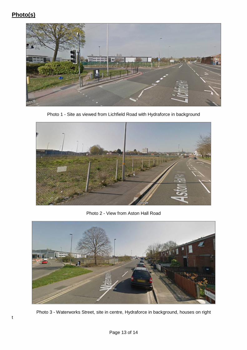
Page 13 of 14
Photo(s)
Photo 1 - Site as viewed from Lichfield Road with Hydraforce in background
Photo 2 - View from Aston Hall Road
Photo 3 - Waterworks Street, site in centre, Hydraforce in background, houses on right t

Page 14 of 14
Location Plan
This map is reproduced from the Ordnance Survey Material with the permission of Ordnance Survey on behalf of the Controller of Her Majesty's Stationery Office © Crown Copyright. Unauthorised reproduction infringes Crown Copyright and may lead to prosecution or civil proceedings. Birmingham City Council. Licence No.100021326, 2010

Birmingham City Council
Planning Committee 16 January 2020 I submit for your consideration the attached reports for the East team. Recommendation Report No. Application No / Location / Proposal Approve – Conditions 14 2019/05988/PA 8A The Gardens
Erdington Birmingham B23 6AG
Change of use from offices (Use Class B1) to 14 bed hostel (Sui-Generis)
Approve – Conditions 15 2019/06258/PA 117 Gravelly Hill North
Erdington Birmingham B23 6BJ
Change of use from surgery (Use Class D1) to residential (Use Class C3), erection of two storey side extension, dormer window to rear and alterations to front
Page 1 of 1 Director, Inclusive Growth (Acting)

Page 1 of 6
Committee Date: 16/01/2020 Application Number: 2019/05988/PA
Accepted: 22/07/2019 Application Type: Full Planning
Target Date: 16/01/2020
Ward: Stockland Green
8A The Gardens, Erdington, Birmingham, B23 6AG
Change of use from offices (Use Class B1) to 14 bed hostel (Sui-Generis) Recommendation Approve subject to Conditions 1. Proposal 1.1. This is an application to convert a vacant building (formerly in office use) to a 14-bed
hostel with shared kitchen and lounge facilities. 1.2 The applicant has advised that the proposed development will provide emergency
temporary accommodation and support to ‘low risk individuals’ (defined as homeless through losing their accommodation, ‘sofa surfing’, in abusive situations etc), whilst more permanent accommodation is being sought. The proposed use will not house alcoholics, drug addicts or ex-offenders with serious criminal records. Referrals will be taken from housing and homeless services/organisations only (there will be no self-referrals) and not from prisons, mental health agencies or substance misuse services.
1.3 The accommodation at ground floor would comprise 10 no. bedrooms, 3 no. kitchens, laundry room, managers/concierge room, computer room, bathroom,
shower room and wc. The first floor would comprise 4 no. bedrooms, bathroom, shower room and wc.
1.4 The site will be for users needing only a low level of support with daily living skills.
Two trained members of staff will remain at the property on a 24 hour basis. No visitors are to be allowed and CCTV cameras will be installed to provide security.
Link to Documents
2. Site & Surroundings 2.1. The building is Grade II listed and has an amenity area to the rear of approximately
300 sq.m area. The site is part of a development dating from the late 19th century/early 20th century known as the ‘Erdington Cottage Homes’, built to accommodate the children of workers of the Aston Union Workhouse. The development consists of a series of individual buildings within a cul-de-sac. The application site is located on the western side of the cul-de-sac and was formerly the Superintendent’s house. The buildings were used as care homes until the mid-1980’s, after which they were used for other purposes (primarily office use) and are
Page 2 of 6
now primarily in residential use. Immediately adjacent at no.10 is a children’s care home. Site Location
3. Planning History 3.1. 2019/06180/PA (Listed Building Consent for internal works in connection with
change of use of the property from offices to a hostel) - approved September 2019.
4. Consultation/PP Responses 4.1. Regulatory Services – No objection subject to a noise insulation condition being
imposed.
4.2. Transportation Development – No objection subject to details of cycle parking provision.
4.3. West Midlands Police – No objection subject to a condition requiring details of site
security measures to be installed (CCTV and door locks).
4.4. Local residents and Ward Councillors have been notified and a site notice displayed. Seven letters of objection from local occupiers have been received, raising concerns over loss of existing residential amenity due to fear of crime and anti-social behaviour by the occupants of the proposed hostel.
5. Policy Context 5.1. National Planning Policy Framework 2019
Birmingham Development Plan 2017 Birmingham Unitary Development Plan 2005 (Saved Policies) Birmingham Conservation Strategy SPG 1999 Specific Needs Residential Uses SPG Places for Living (Adopted Supplementary Planning Guidance 2001) Car Parking Guidelines (2012)
6. Planning Considerations
6.1 The proposed development provides the opportunity of bringing this vacant listed
building back into use, thereby helping to secure its long term future. Listed building consent has already been given for the internal works required in connection with the conversion to the proposed use. The development accords in principle with paragraph 196 of the NPPF which advises that the public benefits of a proposal affecting a listed building should be taken account, with a view to securing its
optimum viable use, BDP Policy TP12 (Historic Environment) which encourages the conservation of designated heritage assets, and Birmingham Conservation Strategy
SPG which encourages the sympathetic use and adaptation of listed buildings. 6.2 The Specific Needs Residential Uses SPG sets out the following criteria for
assessing proposals for hostels:

Page 3 of 6
• Impact on residential amenity; • Cumulative impact; • Highway safety; • Amenity space provision
Residential Amenity 6.3 The SPG advises that hostels are most appropriately located in large detached properties set in their own grounds. In this respect the proposal is entirely appropriate. 6.4 The SPG also requires that proposals should not cause harm to the amenity of
occupiers of nearby properties by reason of noise and disturbance. Many of the buildings in The Gardens are already in relatively high density residential use and it is not considered that the level of activity that would be generated by the proposed use, in terms of general comings and goings, would be so significantly different to the existing character of the road as to unduly impact on existing residential amenity.
6.5 Fear of crime/anti-social behaviour is a material consideration in the assessment of how a proposal may affect residential amenity. In order to carry weight in the determination of an application fear of crime must be based on sound reasons and, additionally, there needs to be reasonable evidential basis for that fear. In this regard it is important to note that West Midlands Police have not expressed any concerns in relation to the proposal – based on the information provided by the applicant relating to the ‘type’ of individual that would be accommodated at the premises and the referral process. It is not considered crime/anti-social behaviour would be a potential consequence of the proposed use. As such refusal of the application on these grounds would not be justifiable. Cumulative Impact
6.6 The SPG advises that the ‘cumulative impact’ of uses such as that proposed on the character and appearance of the area should be taken into account. The immediate surrounding area contains a variety of residential uses, including flats and the children’s care home at no.10. A hostel could be readily accommodated in this setting without causing harm to existing character, particularly as the building meets the SPG requirements of being large and detached. Highway Safety
6.7 No objection to the proposal from Transportation Development as there is likely to be low level of car ownership by the occupants of the building; it is considered that the use will ensure that limited on-street parking will occur as a result of the development. Amenity Space
6.8 The SPG requires the provision of 16sq.m amenity space per resident in order to provide a satisfactory living environment, equating in this case to the need for 232 sq.m to be provided – the rear amenity area at the site is in excess of 300 sqm.
7. Conclusion

Page 4 of 6
7.1 The proposal provides an opportunity to bring back into use a vacant listed building. There would be no adverse impact on the character of the wider area, the existing amenities of nearby residents or highway safety and sufficient amenity space would be provided. The proposal therefore accords with the policies set out in section 5 above.
8. Recommendation 8.1 Approve with conditions. 1 Implement within 3 years (Full)
2 Requires the scheme to be in accordance with the listed approved plans
3 Requires the submission of cycle storage details
4 Requires the submission a Noise Insulation Scheme to establish residential acoustic
protection
5 Requires security measures to be provided
6 A maximum of fourteen persons' occupancy Case Officer: Faisal Agha

Page 5 of 6
Photo(s)
FIG 1: FRONT ELEVATION OF THE APPLICATION SITE

Page 6 of 6
Location Plan
This map is reproduced from the Ordnance Survey Material with the permission of Ordnance Survey on behalf of the Controller of Her Majesty's Stationery Office © Crown Copyright. Unauthorised reproduction infringes Crown Copyright and may lead to prosecution or civil proceedings. Birmingham City Council. Licence No.100021326, 2010
Page 1 of 9
Committee Date: 16/01/2020 Application Number: 2019/06258/PA
Accepted: 25/07/2019 Application Type: Full Planning
Target Date: 18/10/2019
Ward: Gravelly Hill
117 Gravelly Hill North, Erdington, Birmingham, B23 6BJ
Change of use from surgery (Use Class D1) to residential (Use Class C3), erection of two storey side extension, dormer window to rear and alterations to front Recommendation Approve subject to Conditions 1. Proposal 1.1. This application seeks planning permission for the change of use of a redundant
doctor’s surgery (Use Class D1) to a 6 no. bedroom residential dwelling (Use Class C3) and the erection of a two storey side extension at 117 Gravelly Hill North, Erdington.
1.2. The proposed dwelling would have a total floor area of 205.4 square metres (102.7
square metres on both ground and first floors) with external amenity space of approximately 648 square metres to the rear. A single storey extension comprising of a workshop, wc and staff room would be demolished. The proposal would comprise of rendered walls, facing bricks, a slate roof and UPVC window frames to match existing.
1.3. The proposed ground floor would comprise of a communal lounge, (13.7sqm),
kitchen/dining room (19sqm), rear lounge (22sqm) and a study room (11.6sqm).
1.4. The proposed first floor would comprise of 5 no. bedrooms 2 with en-suites), bedroom 1 (10.2sqm), bedroom 2 (10.3sqm), bedroom 3 (13.3sqm), bedroom 4 (13.8sqm) and bedroom 5 (13.8sqm).
1.5. The proposed second floor would 1 no. bedroom (15.4sqm) with an en-suite and a rear dormer.
1.6. The proposal would provide 3 no. vehicle parking provision on-site and proposes a
new boundary wall, removal of the existing right hand entrance footway crossing and the reinstatement of the footpath and a traditional swinging gate to the existing site entrance which would remain unchanged.
1.7. The application is reported to Planning Committee at the request of members on the
grounds that the size and massing of the proposal has the potential to be used as a HMO.
Link to Documents

Page 2 of 9
2. Site & Surroundings 2.1. The application site comprises former doctors surgery located on 117 Gravelly Hill
North with a hipped roof, tarmacked front driveway and a large rear garden. The application was converted to a doctor’s surgery with staff and residential accommodation at first floor.
2.2. The surgery has been empty since 2017 and the adjacent buildings comprise of residential dwellings.
2.3. The surrounding area is predominantly residential and commercial. The Chris Bryant Centre YMCA is situated to the rear (west) of the site, a garage is situated to the south east of the site (opposite side of Gravelly Hill North) and residential dwellings are situated adjoining along Gravelly Hill North.
2.4. Erdington Local Centre is situated approximately 150m north east of the site.
2.5. Access into the site is provided via a driveway off Gravelly Hill North. The access has an existing 2m high boundary fence which is connected to the dwellings to each side.
Site Location
3. Planning History 3.1. 2019/02257/PA: Change of use from surgery (Use Class D1) to 6-bed HMO (Use
Class C4), erection of two storey side extension, dormer window to rear, installation of replacement flat roof with pitched roof to front and erection of single storey detached building to rear to form two studio flats with associated parking and landscaping: Refused: 17.05.19 on the grounds that the rear studio flats would form backland development, introducing a discordant, incongruous and cramped addition to the site that would be harmful to local character and adversely affecting the amenities of both future occupiers of the proposed development and occupiers of dwellings/premises in the vicinity by reason of noise and general disturbance and loss of privacy.
3.2. 2018/02641/PA: Application for a Certificate of Lawfulness for the existing use as a dental surgery (Use Class D1) in excess of 10 years: Withdrawn: 07.06.18.
3.3. 2004/03962/PA: Demolition of building and erection of three-storey building
containing six flats, and provision of new highway access: Approved: 06.12.05.
3.4. 2004/05030/PA: Change of use of ground floor from dental surgery to offices and retention of first floor flat: Approved: 08.10.04.
4. Consultation/PP Responses 4.1. Local Ward Members, Residents Association and neighbouring residents consulted.
Site Notice posted. No objections received. 4.2. Transportation Development – no objections subject to conditions in relation to the
existing footway crossing to be removed and reinstated with full height kerbed footway and details of pavement boundary.

Page 3 of 9
4.3. Severn Trent – No objections.
4.4. Regulatory Services – No objections subject to conditions in relation to noise insulation and the provision of a vehicle charging point.
4.5. West Midlands Police – No objections. 5. Policy Context 5.1. National Planning Policy Framework (2019); Birmingham Development Plan (2017);
Unitary Development Plan (2005, Saved Policies); Places for Living SPG (2001); Car Parking Guidelines (2012); The 45 Degree Code (2006); and Technical Housing Standards – Nationally Described Space Standards (2015).
6. Planning Considerations 6.1. The application has been assessed against the objectives of the policies as set out
above. The main issues for consideration in the determination of the application are as follows:
6.2. Principle of development – The application site is located within an existing residential area and is surrounded by residential development. The proposal would be consistent with the guidance set out within Policy TP27 (Sustainable Neighbourhoods) of the BDP (2017) which relates to sustainable neighbourhoods and states that new housing is expected to contribute to making sustainable places through such things as a mix of housing types and tenures. Policy PG3, policy 3.14A-D of the Birmingham UDP and guidance within SPD’s expects that new development will be designed to a high standard and will reinforce a strong sense of place, the public realm and local distinctiveness. Places for Living SPG encourages good design, the avoidance of any potential adverse impact on neighbouring buildings and also identifies numerical guidelines for garden and separation distances for new residential developments.
6.3. The proposal would reflect the character, form and layout of the existing residential
area. As such, it is considered that the principle of residential development would be acceptable on the application site, subject to satisfying other matters, as discussed below.
6.4. Impact of Highway Safety – The scheme is located within an existing residential
area providing access to sustainable modes of transport and other residential amenities. Transportation Development raise no objections to the proposed development subject to conditions in relation to the existing footway crossing to be removed and reinstated with full height kerbed footway and details of pavement boundary. These conditions are considered appropriate. The proposal would therefore not have a detrimental impact on highways and pedestrian safety.
6.5. Design and Visual Amenity – The design and materials of the proposed side
extension is considered to be acceptable as the proposal would be in keeping with the context of the surrounding area. The proposal would be subservient to the original building and would incorporate vehicle parking to the front and also include rear amenity space. The location of the proposal is considered acceptable and would result in an attractive residential development of good quality and sustainable design which would not result in any adverse impact on visual amenity, streetscene or character of Gravelly Hill North or the wider locality. The provision of an additional residential dwelling in this location would retain active frontages along this section of

Page 4 of 9
Gravelly Hill North and would represent an efficient use of the site and accords with the principles outlined within the Places for Living SPG. The scheme is therefore in accordance with adopted policies in this respect.
6.6. Residential Amenity
6.7 The proposed residential accommodation would provide a gross internal floor area of
205.4 sqm and a total of 6 no. bedrooms. The ground floor would accommodate a communal lounge to the front elevation, a kitchen/dining room, a rear lounge and a study room. The proposed first floor would comprise of 5 no. bedrooms. The proposed second floor would comprise 1 no. bedroom with an en-suite and a rear dormer.
6.8. The bedrooms would measure between 10.2sq.m and 15.4sq.m respectively and the
gross internal floor area of 205.4sq.m would comply with the Technical Housing Standards – Nationally Described Space Standards (2015). Externally, the rear garden areas would exceed the required 70sq.m for 6 bed dwellings as stipulated within Places for Living SPG and would approximately measure 648 sqm. It is considered that the proposed change of use to a dwelling would provide future occupiers with a satisfactory standard of residential accommodation and amenity.
6.9. Places for Living SPG stipulates a minimum setback for residential development of 5m per storey (10m for a two storey building and 15m for a three storey building) from residential boundaries where main windows of new development overlook private amenity and this has been achieved with the proposed dwelling. The siting of the proposed dwelling would comply with the 45 degree code in relation to existing adjacent dwellings along Gravelly Hill North.
6.10. Regulatory Services have no objection subject to the provision of planning conditions in relation to a vehicle charging point and a specification for the proposed glazing and ventilation to achieve RW 40. Therefore the proposed glazing and ventilation would provide an acceptable standard of living conditions for future occupiers with regards to a satisfactory standard of external traffic noise levels and air quality, especially on the front façade. I concur with this viewpoint. However, I do not consider the provision of electric vehicle charging points necessary in this case as the house would have the facility for future occupiers to install such infrastructure should they wish to.
6.11. The proposal would allow for an adequate level of residential amenity and good quality residential living environment for future residents. Therefore the scheme is considered acceptable in terms of residential amenity for existing and future occupiers and is in accordance with Policy PG3 of the BDP and adopted guidance set out on ‘Places for Living’.
7. Conclusion 7.1. The scheme is recommended for approval as is complies with the objectives of the
policies as set out above.
8. Recommendation 8.1. Approve, subject to conditions.

Page 5 of 9
1 Requires the scheme to be in accordance with the listed approved plans
2 Requires the submission of details of pavement boundary
3 Requires the submission and completion of works for the S278/TRO Agreement
4 Requires the submission a Noise Insulation Scheme to establish residential acoustic protection
5 Requires the submission of hard and/or soft landscape details
6 Requires the submission of boundary treatment details
7 Implement within 3 years (Full) Case Officer: Harjap Rajwanshi

Page 6 of 9
Photo(s)
Figure 1: Front Elevation

Page 7 of 9
Figure 2: Rear Elevation
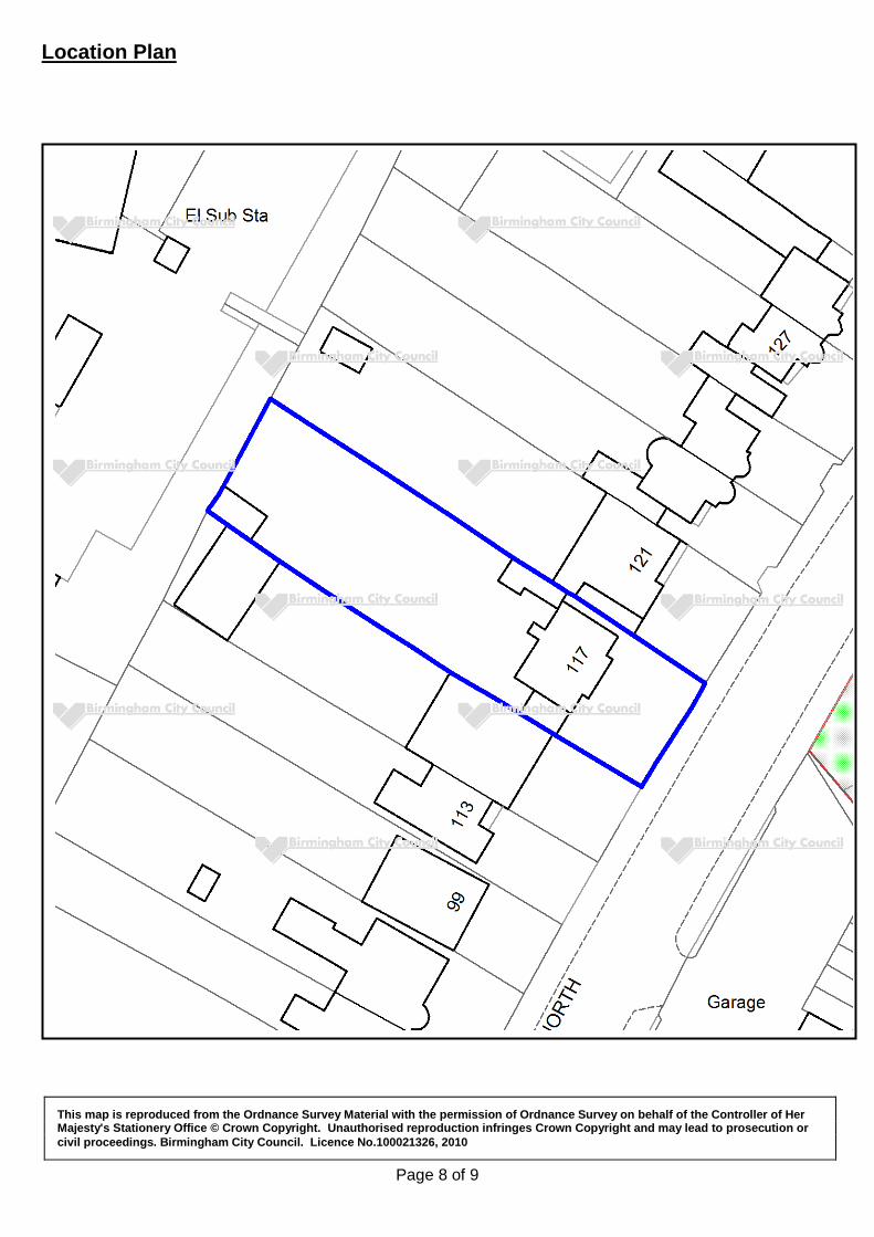
Page 8 of 9
Location Plan
This map is reproduced from the Ordnance Survey Material with the permission of Ordnance Survey on behalf of the Controller of Her Majesty's Stationery Office © Crown Copyright. Unauthorised reproduction infringes Crown Copyright and may lead to prosecution or civil proceedings. Birmingham City Council. Licence No.100021326, 2010

Page 9 of 9