Planning Applications Committee Report ERECTION...
40
Steve Rogers – Head of Planning & Regulatory Services Kirkbank, English Street, Dumfries, DG1 2HS Telephone (01387) 260199 - Fax (01387) 260188 Planning Applications Committee Report ERECTION OF 5 WIND TURBINES (3 AT 140M TO BLADE TIP, 2 AT 120M HIGH TO BLADE TIP), 1 METEROLOGICAL MAST (80M HIGH), AND ANCILLARY INFRASTRUCTURE INCLUDING SUBSTATION / CONTROL BUILDING, NEW ACCESS TRACKS, BORROW PITS, AND HARDSTANDINGS AT LAND TO EAST OF BLACKCRAIG HILL, HIGH AULDGIRTH, DUMFRIES (BLACKWOOD WIND FARM) Application Type: Full Planning Permission Applicant: Force 9 Energy LLP Ref. No.: 12/P/3/0060 Recommendation - Refuse Ward - Mid and Upper Nithsdale Hierarchy Type (if applicable) - Local Case Officer - Lindsey Cameron 1 BACKGROUND 1.1 Under the Scheme of Delegation, this application requires to be considered by the Planning Applications Committee because more than 6 separate, individual and timeously received third party objections on material planning grounds have been received. Site location and description 1.2 The application site, extending to some 305 hectares, is located immediately to the west of the existing Dalswinton wind farm and stretches west as far as the A76 trunk road, including parts of the settlement of Auldgirth. The A76 is located some 2.1km from the nearest turbine, at its closest point. The settlements of Auldgirth, Park, and Closeburn are 2.1km, 2.8km, and 4.4km distant respectively from the nearest proposed turbine, with Dumfries approximately 10km to the south. 1.3 The proposed windfarm development would occupy the western slopes of Pennyland Burn, a steep valley between Fern Hill (290m AOD) (where Dalswinton windfarm is located) to the east and Blackcraig Hill (240m AOD) to the west. The site is bounded to the north by the Clauchrie Plantation and Clauchrie Hill (258m AOD) and to the south by Mullach Hill (245m AOD). Land uses around the proposed wind farm are predominately
Transcript of Planning Applications Committee Report ERECTION...

Steve Rogers – Head of Planning & Regulatory Services Kirkbank, English Street, Dumfries, DG1 2HS Telephone (01387) 260199 - Fax (01387) 260188
Planning Applications Committee Report ERECTION OF 5 WIND TURBINES (3 AT 140M TO BLADE TIP, 2 AT 120M HIGH TO BLADE TIP), 1 METEROLOGICAL MAST (80M HIGH), AND ANCILLARY INFRASTRUCTURE INCLUDING SUBSTATION / CONTROL BUILDING, NEW ACCESS TRACKS, BORROW PITS, AND HARDSTANDINGS AT LAND TO EAST OF BLACKCRAIG HILL, HIGH AULDGIRTH, DUMFRIES (BLACKWOOD WIND FARM) Application Type: Full Planning Permission Applicant: Force 9 Energy LLP Ref. No.: 12/P/3/0060 Recommendation - Refuse Ward - Mid and Upper Nithsdale Hierarchy Type (if applicable) - Local Case Officer - Lindsey Cameron 1 BACKGROUND 1.1 Under the Scheme of Delegation, this application requires to be considered by the Planning Applications Committee because more than 6 separate, individual and timeously received third party objections on material planning grounds have been received. Site location and description 1.2 The application site, extending to some 305 hectares, is located immediately to the west of the existing Dalswinton wind farm and stretches west as far as the A76 trunk road, including parts of the settlement of Auldgirth. The A76 is located some 2.1km from the nearest turbine, at its closest point. The settlements of Auldgirth, Park, and Closeburn are 2.1km, 2.8km, and 4.4km distant respectively from the nearest proposed turbine, with Dumfries approximately 10km to the south. 1.3 The proposed windfarm development would occupy the western slopes of Pennyland Burn, a steep valley between Fern Hill (290m AOD) (where Dalswinton windfarm is located) to the east and Blackcraig Hill (240m AOD) to the west. The site is bounded to the north by the Clauchrie Plantation and Clauchrie Hill (258m AOD) and to the south by Mullach Hill (245m AOD). Land uses around the proposed wind farm are predominately

based on forestry and agricultural grassland. The Auldgirth (Formerly Burntkettle) Shooting Ground occupies an area in and around Glenloy Forest within the northern part of the application site. A network of small streams cross the site. 1.4 The closest residential properties would be the cluster of dwellings at High Auldgirth, located 780m from the nearest proposed turbine and in terms of landscape designations, the application site lies partly within the Thornhill Uplands Regional Scenic Area. Description of Proposal 1.5 The full details of the proposed windfarm are contained within the submitted Environmental Statement (ES), and would comprise:-
5 three-blade horizontal axis wind turbines; 3 of the turbines (Turbines 1, 3, and 5) would be of up to 100m hub height and 140m tip height, the remaining 2 turbines (turbines 2 and 4) would be of up to 80m hub height and 120m tip height, with a typical rating of 2.05MW;
turbine foundations (20 x 20 metres) and crane hardstandings (30 x 50 metres approximately);
1 permanent lattice tower anemometer mast of 80m in height;
construction of new permanent access tracks (3.3km) and upgrading of existing tracks (2.2km);
construction of substation and control building;
onsite underground cabling;
2 temporary borrow pits; and,
1 temporary construction compound (50 x 30 metres approx.). 1.6 The proposed wind farm would have a maximum electricity generating capacity of 10.25 MW. The proposal, therefore, constitutes 'local' development as defined under the Town and Country Planning (Hierarchy of Developments) (Scotland) Regulations 2009 and is not subject to statutory pre-application consultation. However, the applicant chose to undertake a programme of public consultation prior to the submission of the application. 1.7 The proposed means of access to the site would be via the A76 at Auldgirth, crossing the C11 and onto the U492n, an unclassified public road that leads east to Low Auldgirth via a bridge over the operational railway line. Given the constraints along a section of the existing road, a new private access track of 1.2km is proposed, which would be routed around Low Auldgirth, through open agricultural land, to rejoin the existing private road above Low Auldgirth and continue thereafter to High Auldgirth and the turbine site beyond. New internal access tracks to the control building and each turbine position are also proposed. The total length of new access tracks would extend to some 3.3km. Access tracks would generally be 5m wide, with passing places, during construction and, thereafter reduced to 3.5 metres wide for the duration of the wind farm development. 1.8 The application includes proposals for decommissioning of the wind farm following its anticipated 25 year design life which would include removal of turbines, transformers and the control building. Planning History 1.9 Relevant planning history:
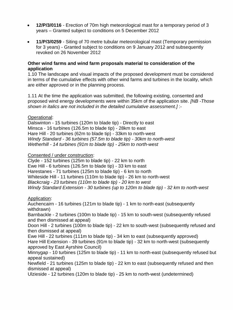
12/P/3/0116 - Erection of 70m high meteorological mast for a temporary period of 3 years – Granted subject to conditions on 5 December 2012
11/P/3/0259 - Siting of 70 metre tubular meteorological mast (Temporary permission for 3 years) - Granted subject to conditions on 9 January 2012 and subsequently revoked on 26 November 2012
Other wind farms and wind farm proposals material to consideration of the application 1.10 The landscape and visual impacts of the proposed development must be considered in terms of the cumulative effects with other wind farms and turbines in the locality, which are either approved or in the planning process. 1.11 At the time the application was submitted, the following existing, consented and proposed wind energy developments were within 35km of the application site. [NB -Those shown in italics are not included in the detailed cumulative assessment.] :- Operational: Dalswinton - 15 turbines (120m to blade tip) - Directly to east Minsca - 16 turbines (126.5m to blade tip) - 28km to east Hare Hill - 20 turbines (62m to blade tip) - 33km to north-west Windy Standard - 36 turbines (57.5m to blade tip) - 30km to north-west Wetherhill - 14 turbines (91m to blade tip) - 25km to north-west Consented / under construction: Clyde - 152 turbines (125m to blade tip) - 22 km to north Ewe Hill - 6 turbines (126.5m to blade tip) - 33 km to east Harestanes - 71 turbines (125m to blade tip) - 6 km to north Whiteside Hill - 11 turbines (110m to blade tip) - 26 km to north-west Blackcraig - 23 turbines (110m to blade tip) - 20 km to west Windy Standard Extension - 30 turbines (up to 120m to blade tip) - 32 km to north-west Application: Auchencairn - 16 turbines (121m to blade tip) - 1 km to north-east (subsequently withdrawn) Barnbackle - 2 turbines (100m to blade tip) - 15 km to south-west (subsequently refused and then dismissed at appeal) Doon Hill - 2 turbines (100m to blade tip) - 22 km to south-west (subsequently refused and then dismissed at appeal) Ewe Hill - 22 turbines (111m to blade tip) - 34 km to east (subsequently approved) Hare Hill Extension - 39 turbines (91m to blade tip) - 32 km to north-west (subsequently approved by East Ayrshire Council) Minnygap - 10 turbines (125m to blade tip) - 11 km to north-east (subsequently refused but appeal sustained) Newfield - 21 turbines (125m to blade tip) - 22 km to east (subsequently refused and then dismissed at appeal) Ulzieside - 12 turbines (120m to blade tip) - 25 km to north-west (undetermined)

Margree - 23 turbines (125m to blade tip) - 22 km to west (undetermined) Afton - 27 turbines (120m to blade tip) - 31 km to north-west (subsequent S36 application refused) Pre-Application: Harestanes Extension - 7 turbines (126.5m to blade tip) - 12 km to north-east (subsequent S36 application refused following PLI) Leadhills - 7 turbines (137m to blade tip) - 29 km to north - (subsequent planning application refused) Only Dalswinton, Harestanes and Auchencairn lie within 10km. All of the above developments are mapped on Figures 8.26 and 8.27 of the ES. 1.12 Since the submission of the application, further applications for wind farm development have been received, determined or withdrawn within the 35km study area. Most notably, the only change within 10km and which is of relevance in the assessment of the current application, is withdrawal of the application for Auchencairn wind farm, which would have been located immediately to the north of Dalswinton wind farm and 1km north-east of the proposal. Supporting information 1.13 An EIA scoping opinion was issued by the Council under reference 11/E/3/0011 on 4 July 2011 which gave advice on the scope of the information to be included within the EIA. 1.14 The application was subsequently submitted on 13 February 2012 and included the submission of the following documents:
An Environmental Statement (ES), including Non-Technical Summary, as required under the Town & Country Planning (Environmental Impact Assessment) Regulations 2011. The ES assesses the likely significant environmental effects of a project and sets out ways of reducing any adverse effects. The ES comprises the following chapters:- 1. Introduction
2. Project Alternatives and Design Evolution
3. Project Description
4. Planning
5. Physical Environment
6. Ecology
7. Ornithology
8. Landscape and Visual Amenity
9. Archaeology and Cultural Heritage
10. Noise
11. Traffic and Transport
12. Climate Change
13. Socio-Economics
14. EMI, Infrastructure, Safety and Aviation
15. Shadow Flicker
16. Environmental Management

A Planning Statement
1.15 An additional supplementary Planning Statement, including Appendix A (Aviation / Radar response) and Appendix B (Landscape response), was submitted in March 2014. 2 CONSULTATIONS 2.1 Council Landscape Architect - Objection. (Response dated 9 January 2014) The proposals are not supportable and are subject to a D&G Landscape objection based on significant adverse landscape and cumulative visual effects of the proposed turbines, as a result of the following key issues: Key issues - The proposals would introduce large scale windfarm development in to the sensitive Ae Fringe (LCT 16) unit, and into the immediate setting of Dalswinton Windfarm. There would be visual issues with sensitive receptors around the transition between lower and mid Nithsdale. Significant adverse issues: (a) The Blackwood turbines would be prominent from the Mullach, and there are scale issues with the local landscape character of the Ae Fringe (LCT) 16 around the Pennyland Burn valley, and in terms of ‘landscape fit’ with Dalswinton wind farm. (VP 19)
(b) The proposed turbine group would introduce an additional skyline feature, with an awkward relationship to Dalswinton wind farm, and impinging on the setting of the Mullach, a local landmark; appreciated in short / mid-range views from the area between lower and mid Nithsdale, including the A76 key tourist route, and a number of historic and designed landscapes. (VPs 7, 8, 13)
(c) Visual effects on local residential receptors in lower and mid Nithsdale. (VPs 3, 5, 13) Issues of serious concern, but not judged significant: (a) Blackwood would extend Dalswinton, and wind farm development generally, in to closer proximity with mid Nithsdale, impinging on the character of the valley, and with a greater degree of visual prominence from sensitive valley receptors, residents and visitors to Closeburn, Thornhill, and Drumlanrig Castle. (VPs 3, 4, 5)
(b) In longer range views, from the south around Dumfries, and from the east around Lockerbie, Blackwood would further extend the spread of wind farm development as a characteristic of the skyline of the Ae foothills. (VPs 9, 10, 11, 14)
(c) In medium and longer range elevated views from designated uplands, the Torthorwald Ridge (RSA), Terregles Ridge (RSA), the Keir Hills (Thornhill Uplands RSA), and to a lesser degree from Criffel (Nith Estuary NSA), Blackwood extends windfarm development in to a greater degree of prominence in relation to the views and outlooks from these areas, and also in relation to the valley edge of mid Nithsdale. (Cultural Heritage VPs Back Hill, Bishop Forest Hill, and Wauk Hill, and VP 16) 2.2 SNH - No objection, subject to conditions. (Response dated 10 April 2012) (a) Habitat and Ecological Interests - SNH broadly agree with the findings of the ES in relation to the ecological impacts of the proposal. SNH is content that whilst some protected species were not detected by survey, or those that were are not considered to

be under immediate threat as a result of this development nonetheless the section on mitigation provides for protected species by the adoption of best working practices. SNH welcome the production of a Construction Environmental Management Plan (CEMP), which would encompass a Habitat Management Plan and Reinstatement and Restoration Plan. (b) Ornithology - Work undertaken at this site is adequate. Ornithological interest is relatively low and as such there are no grounds on which to raise an objection. SNH do suggest that any positive management proposed is away from the turbines to the south-west of site and only undertaken with SNH agreement. (c) Landscape and Visual Impact - SNH consider this landscape type to have some capacity for wind development. However, with the construction of Dalswinton and consent and construction beginning of Harestanes, further capacity has to be called into question. SNH also has concerns as to the impact upon the Thornhill Uplands Regional Scenic Area (RSA). SNH believe impacts are a function of the development's relative prominence on the ridge, turbine height and that the impacts occur over an area of high amenity value and within a relatively diverse landscape setting. Whilst SNH has a number of concerns in relation to this development these are not a basis on which to raise an objection. 2.3 Keir Community Council:- Objection. (Response dated 20 March 2012) (a) The visual impact of this development, alongside Dalswinton and Harestanes wind farms will be significant, adversely impacting on the landscape and scenic beauty of the area. The site is adjacent to Thornhill Scenic Area and would have a detrimental effect on the area, and its attraction as a tourist centre. (b) The application site is outwith the areas generally recommended for turbine development according to the (then) Interim Planning Policy: Wind Energy Development (IPP:WED). It has not been identified as having high wind potential and experience from neighbouring Dalswinton shows very poor wind efficiency levels. This development will further reduce the efficiency of Dalswinton by interrupting their prevailing wind flow. (c) Noise generated would impact negatively on nearby residents. There is increasing evidence that noise pollution from turbines affects sleep patterns and is detrimental to the health of residents living nearby. These turbines are well within the 2km exclusion zone recommended. (d) The site is adjacent to an area that the RSPB and SNH have identified as being sensitive due to the bird and wildlife populations. These will be adversely affected, not just by the turbines, but also by the disruption caused by construction works, and by the loss of habitat this will result in. 2.4 Closeburn Community Council (note: currently considered to be dissolved):- Objection. (Response dated 4 May 2012) Visual Impact (a) The site is classed as highly sensitive to wind turbines of this size in the IPP: WED. The ES and its photomontages understate the visual and landscape impact as the visible landscape will be severely damaged over a wide area. (b) The Blackwood site is adjacent to Dalswinton wind farm, and the consented Harestanes. It would fill a gap between the two giving a significant cumulative effect especially when viewed from the west and north. There will be no perceived gaps between all three windfarms especially from the east and north. The formation of turbines at Blackwood Wind Farm is very dense and thus not compatible with the patterns of adjacent

operations. This will make them incompatible with the foothills landscape and form the dominant feature in the Nith Valley so contravening Structure Plan Policy E3 and IPP: WED Development Management Policy. (c) Blackwood wind farm site being close to the edge of the foothills is very close to the Nith valley centre at the Auldgirth ‘pinch point’ and will appear to block the visible valley when seen from the North or South. (d) The height and size of these turbines does not fit the scale or nature of the landscape around Auldgirth village. They will appear dominant and massive so contravening Structure Plan Policy E3 and IPP: WED. Thornhill Regional Scenic Area (a) The wind farm development is immediately adjacent to the Thornhill Regional Scenic Area and will change the character of this designated landscape, contravening SPP E2 and SPP 21. The turbines will be clearly part of the visual envelope of the RSA and thus a dominant feature in the landscape given their height and prominence. They will severely damage the setting of the Regional Scenic Area and contravene Structure Plan Policy E2, as it would adversely affect the landscape character and scenic interest for which the area has been designated. In the IPP: WED Spatial framework, the Regional Scenic Area is classed as an area with potential constraint and one to be protected. Road access (a) Access would use the small road alongside Auldgirth village hall and up the single track U492 which is unsuitable and dangerous for residents & pedestrians given the high number of heavy traffic movements planned (3,488 heavy). The route is steep and has very tight corners plus a small compact rail bridge to negotiate. The proposed un-made new road will also have a very steep gradient plus a slippery surface in winter/wet weather that will affect traction and have a high risk for sliding and slipping. Heavy vehicles travelling downhill, even unladen, will also be prone to ‘running away’ unless extreme care is taken. Moving turbine equipment, gravel and concrete through the village on this scale will have a dramatic impact on village life as well as raising safety issues. There will need to be passing places for traffic using the Burntkettle shooting ground. (b) The new road will also be a new scar on the landscape clearly visible from the A76 tourist route. Noise (a) It is generally accepted, as the IPP states, that wind turbines should not have residential housing within a 2 km zone around them. This application totally ignores this with properties within 700m at High Auldgirth and much of Auldgirth village within 2km. This will make living at High Auldgirth very difficult whilst Auldgirth village will suffer substantial noise effects especially with easterly winds. (b) There is growing evidence from residents around windfarms that show that turbines cause significant and on-going medical issues. The British Medical Journal recently published a paper by Christopher D Hanningby that shows that a large body of evidence now exists that wind turbines disturb sleep and impair health. Studies in Europe, the USA and New Zealand have shown that this is most serious for residents living within 2 km of any turbines. (c) The aerodynamic noise generated by wind turbines produces a large amount of low-frequency and infrasound component that does not diminish over distance when compared

with higher frequency noise. Turbines produce both high and low frequency noise. Current noise measurement techniques like the ones used for Blackwood tend to obscure the contribution of low-frequency noise and infrasound and thus this EIS understates the impact of this element of noise on surrounding residents. Sleep disturbances are obviously more serious at night when the noise levels allowed under current legislation are actually higher. (d) As well as sleep deprivation turbines also cause stress as measured in studies like that undertaken around the Mars windfarm in Maine USA. This showed that 80% of residents living within 2 km of the turbines suffered from stress and subsequent ill-health. This stress is often linked to memory loss but there is now evidence to show that diabetes and heart conditions are also related. There is also evidence to show that people living in very quiet rural environments have much less tolerance to high noise levels making the impact of any increase in noise is significantly worse for rural residents. (e) Noise measurements also tend to ignore the fact that wind-shear occurs (i.e. wind speeds are higher at the height of turbine blades than down on the ground where residents live) as often happens in the early morning or late evening. This EIS again understates the noise impact on surrounding residences from wind shear. Turbines will produce intrusive noise at surrounding houses in the early mornings or late evenings which are traditionally peaceful times of day. (f) The noise measurements offered in the EIS for Blackwood where not taken by the developers but ‘cut and pasted’ from the Auchencairn Forest wind farm EIS and thus they are not real or up-to-date. (g) The ES does not show current background noise levels for the monitoring undertaken and thus it is very difficult to gauge from this EIS the actual increase in decibel levels to be caused by the turbines. This is very important given the nature of the decibel scale where a 10 Decibel change means a doubling of the noise. Background levels locally are often in the mid-20s. If turbines are expected to be in the 35dB range then this will means a doubling of the background noise for residents. This is totally unacceptable. (h) This application works hard to understate the noise impact. It’s likely that the impact will be much higher because the noise will be blown from the turbines down the hill towards properties. This ES ignores the effects of topography on the range noise can travel. Proximity (a) It seems very strange that the applicant has included much of Auldgirth village in the wind farm area. This may have psychological, health and amenity effects on residents. Carbon balance (a) No mention is made of the carbon balance of this proposal. As large amounts of concrete are involved in turbine foundations Closeburn Community Council would be looking for extensive planting of trees to offset the CO² emissions generated from making the concrete. Clauchrie Woodland - Social & community woodlands & Tourism
(a) Clauchrie Community Woodlands is immediately North of the site and Closeburn Community through its local charity Nith Valley LEAF Trust is currently in negotiation with the Forestry Commission Scotland to lease the 235ha woodland as a community forest. This is likely to be a 100 year plus leasing arrangement – thus making it effectively permanent and covering the lifespan of the wind farm. The aim of NVLT is to maintain

Clauchrie woodlands as a place of tranquillity for residents, tourists and the current wildlife whilst developing it as a centre for education and training in environmental and wildlife skills. Having turbines sited right on top of the Clauchrie Woodland boundary would generate intrusive noise and have a potentially serious effect on wildlife including the nesting of protected species like Goshawks using the Clauchrie Burn valley. Tourism would also be significantly affected. Clauchrie Woodland includes D&G Core path 4442. Ecology & Wildlife (a) Clauchrie and the sounding area are a haven for a wide variety of birds and wildlife. This ES provides scant information on the bird & wildlife bird life of the area. Compared to the EIS undertaken by the developers for Auchencairn Forest wind farm it misses out much of the wildlife and ornithology of the area. Surveys have been restricted to the actual turbine site which bears no relationship to the areas which birds or animals actually range across or inhabit. For example, this area is well known for the number of nesting goshawks yet the ES dismisses them because none are actually nesting in the area around the turbines. (b) The surveys undertaken and arguments offered in the EIS thus grossly underestimate the actual populations of birds like goshawks that use this area. A full raptor survey is essential because current and future felling of timber in the Harestanes wind farm development mean that this application will exasperate the situation for internationally protected species like Goshawks and then offer no mitigation measures at all. These turbines will provide a major threat to the lives of Goshawks, other raptors and migrating geese. Tourism (a) These turbines will be very visible from the A76 tourist route as well as by residents in the Nith Valley and a wide range of tourist venues like Drumlanrig Castle, Thornhill Village, Ellisland Farm, Allanton World Peace Sanctuary, Portrack House and the Garden of Cosmic Contemplation, Macmillan’s Smithy, Friars’ Carse Hotel & Trigony House Hotel. (b) There is a growing body of evidence (Caledonian University, 2008) that shows tourists are deterred by wind turbines and will avoid and not recommend areas with turbines or return for a repeat visit. Projections show that Dumfries and Galloway is likely to suffer a £3 million drop in income and the loss of 200 jobs due to tourists avoiding area with wind farms. A 2005 Scottish Government commissioned study highlighted the importance of tourism as the “leading private sector cluster” to Dumfries and Galloway’s economy and the 1999 structure plan places great emphasis on growing the tourist economy. This application undermines that initiative and Council policy. Suitability of site for maximum efficiency (a) This area was not identified as having high wind potential in the current Structure Plan 22 and Technical Paper 5 and the Wind Energy Diagram. The poor efficiency of Dalswinton (20.3%) demonstrates this. Blackwood will under normal prevailing winds be downwind from Dalswinton and with E and NW winds respectively of Harestanes and Auchencairn Forest (if built). This means either Blackwood will only collect wind energy ‘left’ after passing adjacent wind turbines or it will reduce the wind energy available to them so reducing efficiency even more. Conclusion

(a) The Dumfries and Galloway Landscape Planning policy states that; "The quality of landscape is one of Dumfries and Galloway’s major assets, providing an attractive environment for both residents and visitors.” This proposal destroys this asset for a large number of residents and visitors. There is no evidence of need for this wind farm as Dumfries and Galloway has already contributed considerably to the renewable targets set by the Scottish Government with existing and already approved wind farms. These turbines are totally unsuitable for this area and its landscape. 2.5 Thornhill Community Council (note: currently considered to be dissolved):- Objection. (Response dated 19 March 2012) (a) The application site is outwith the areas generally recommended for turbine development according to Interim Planning Policy: Wind Energy Development, showing areas of search suitable for wind farms. The area is classified as having limited potential and part of the site is within and the rest adjacent to Thornhill Uplands Regional Scenic Area. It is unsuitable for turbines of this height; three turbines are 140m high, the highest in Dumfries & Galloway. (b) The proposed wind farm would be situated in a very prominent position next to Dalswinton Wind Farm and in front of Harestanes Wind farm hereby increasing both the size and scale of the wind farm and the visual impact on the landscape. (c) Noise generated could impact negatively on nearby residents. The turbines are close to homes at High Auldgirth and they will suffer from the noise of the turbines. Noise is becoming a much greater nuisance to residents countrywide and needs greater weighting in the assessment of this wind energy project. The proposed wind farm is too close to houses so preventing residents from enjoying the tranquil environment of their homes. All Dumfries and Galloway residents should be afforded the utmost protection to both their residential amenities and their health. (d) The access to the site is by a small narrow road through the village that crosses the railway. The new access road will create a highly visible track on the hillside behind the village. These roads are unsuitable for the heavy construction lorries and the turbine transporters. (e) Newly planted forest will be destroyed and have an impact on wildlife in the area. There are goshawks in the area which must be protected. (f) Many in the area depend on tourism to support their businesses. The turbines are clearly visible from and would have an adverse impact on important tourist centres in the locality and on the A76 tourist route. Visit Scotland stated on their submission to Interim Planning Policy: Wind Energy Development, that tourists find even single turbines to be off-putting. 2.6 Council Roads Officer:- No objection subject to conditions. Final comments dated 21 April 2016 – It should be noted that planning permission has been recently granted (16/P/3/0008) for a campsite at Low Auldgirth steading that will result in an increase in pedestrian and vehicular use of the U492n from its junction with the U541n to the access to Low Auldgirth Farm. The required TMP will need to reflect that and address any resultant pedestrian and road safety concerns. The comments from the applicant’s agents are noted in respect of the access considerations and in particular:-

Carriageway improvements - The access route is to be re-assessed in detail and the extent of any accommodation works (such as widening, strengthening, provision of suitable passing place etc. along the proposed access route necessary to permit construction traffic and the passage of AILs (Abnormal Indivisible Loads)) to public roads to be agreed. Proposals for all accommodation works should be supported by swept path tracks. All accommodation works on public roads must be designed and constructed to the satisfaction of the planning authority in consultation with the roads authority and will require appropriate permits and consents to have been issued.
Traffic Management Plan - The TMP should include a programme of delivery types/numbers by month, details of all proposed mitigation measures, agreed access and excluded routes and details of measures that will be implemented to ensure that no stacking of delivery vehicles occur on any part of the public road network and is to be agreed in writing with the Police and the roads authority prior to any works commencing on site.
Damage to Public Road - The developer will be held responsible for the immediate execution of any repairs and will be required to meet the cost of above average maintenance to the public road network arising from the concentration of heavy traffic associated with this development. It would be appropriate that a legal Maintenance Agreement (S96) is agreed and executed between the applicant and Dumfries and Galloway Council prior to the commencement of any accommodation works that unambiguously sets out the remit and extent of the inspection and maintenance regimes, extents of responsibility and agreed repair timescales during the course of the works.
In addition:-
Any carriageway overlays on the approach to or exit from the railway bridge that have the effect of reducing the height of the parapet may require the raising of the parapet to maintain a safe minimum height. This should be agreed with Network Rail prior to any works commencing.
Where public road boundaries are altered either for the formation of temporary accesses or for accommodation works, these should be reinstated in their original position at the conclusion of construction works (unless prior agreements have been secured with the planning and road authorities).
There should be consultation with nearby forest managers and timber hauliers through the office of the South of Scotland Timber Transport Officer to co-ordinate timber haulage operations that may use the wind farm access route during the construction period to minimise the cumulative impact on communities and road users.
Additional comments dated 24 November 2014 – The plans submitted (6 October 2014) are limited to the immediate area surrounding the railway bridge on the U492n public road. Whilst the requirement for vertical and horizontal alignment alterations to accommodate turbine component deliveries is accepted, it would be appropriate that any proposals are considered as part of an overall package of required accommodation works between the A76 Trunk Road and the end of the U492n public road (widening, strengthening, passing places and boundary alterations). This has not been provided. It should be noted that as construction is likely to extend over an approximate 9 month

period and there will remain the possibility that components (such as a blade) may require replacement during the lifetime of the development, any accommodation works should be considered, at least, as semi-permanent. This will apply to realignments of the carriageway and the public road boundary. Where the vertical profile of the carriageway is being altered, consideration should also be given to the effect on the adjacent verges and boundaries which may also require alteration. In respect of the proposed method for altering the vertical profile, the use of Type 1 and geotextile might be considered acceptable for a temporary solution but would not be considered appropriate for an extended use running surface. There would also be concern over damage to the existing road edges and areas of tie-in. It should be noted that any above average maintenance expenditure on the public roads as a result of haulage traffic to the site may be recoverable from the applicant/operator. Initial comments dated 9 March 2012 – (a) The U492n public road is locally restricted in width and geometry with few passing opportunities and there is a significant railway bridge. (b) The supply of temporary services to the site compound may require the issuing of a permit under Sections 56 and 61 of The Roads (Scotland) Act 1984. (c) The installation of the grid connection would have an impact upon public roads where the route follows a road, crosses a road or crosses a bridge on the road and therefore it is anticipated that this would be subject to a separate application and a detailed plan and comprehensive programme of works/method statement should accompany any application. (d) It would be appropriate that the applicant supply details of the type and dimensions of cranes that will be used on site. (e) A Traffic Management Plan (TMP) to be agreed with the Police and the Development Team Leader (Nithsdale) will require to be developed (that identifies traffic volumes, agreed routes and mitigation measures) prior to any construction works commencing on site. (f) Any above average maintenance expenditure on the public roads as a result of haulage traffic to the site may be recoverable from the applicant / operator. (g) The "Site Access Review" carried out by Grontmij in December 2010 identifies several areas along the identified route where additional land outwith the public road boundary is required. A detailed report of all construction work required along with confirmation that the applicant has the relevant consents in place to carry out the required work on these areas should be provided. (h) It would be appropriate that a proposal for any necessary accommodation works along public roads, including passing place provision in accordance with Council standards (intervisible or not more than 200m apart), be provided by the applicant. (i) The "Site Access Review" also notes a potential issue with the vertical alignment of the railway bridge, a full topographical survey is recommended in the report to ensure that the delivery vehicles will not "ground out" on the bridge. This information is not included in the Environmental Statement and should be submitted prior to any consent being granted. 2.7 Transport Scotland:- No objections subject to conditions regarding approval of abnormal load route and signage. (Response dated 13 March 2012).

2.8 MoD:- No objections subject to conditions (Response dated 23 June 2014) This site is approximately 37 km from the seismological recording station at Eskdalemuir and falls within its statutory safeguarded area. Following completion of further work and following publication by the Scottish Government of its interim guidance on Eskdalemuir on 22 May 2014, MoD is able to withdraw its Eskdalemuir objection for the following reasons: 1. the outcome of the significant scientific research which has been undertaken at the instance of the Eskdalemuir Working Group ("EWG"); 2. the endorsement by the EWG of the Stage 1 technical report; and 3. the publication by the Scottish Government of its interim guidance on Eskdalemuir dated 22 May 2014. The Scottish Government has confirmed that the substantive research undertaken at the instance of the EWG - referred to as the Stage 1 research, and the resultant Stage 1 report - has been completed and was endorsed by the EWG at its meeting on 28 April 2014. It is understood that the final report – Seismic vibration produced by wind turbines in the Eskdalemuir region - will be published in the coming weeks on the Scottish Government website. This substantive research, conducted by Xi Engineering with the close cooperation and input of MoD, has confirmed that there is headroom in the budget to allow further wind farm consents without breaching the 0.336nm threshold. The interim planning guidance was published in light of the recommendations of the EWG. MoD has agreed to withdraw its objections (in relation to the operation of the seismological monitoring station) to wind development proposals within the 50km consultation zone that were submitted prior to December 2013, including the present development, in accordance with the interim guidance. As noted in the Scottish Government's interim guidance: "The new model uses hub height, rotor diameter and distance from the array to calculate the predicted seismic noise from turbines. These parameters can vary when a development is actually constructed (through turbine choice and micro-siting), therefore it is important that the MoD is notified of the final built positions and specifications of turbines for the purposes of managing the noise budget efficiently. Planning authorities should therefore ensure that a planning permission condition ensures that the developer submits final details of hub height, rotor diameter and location of turbines as implemented to the MoD. Planning authorities should monitor and take any necessary enforcement action to ensure that such conditions are timeously discharged. The seismic ground vibration contribution for any development will ultimately be that which is calculated from these final parameters.” MoD would therefore request that the following condition be attached should permission be granted: "As soon as reasonably practicable following completion of construction of the turbines on

the site, the Company shall provide written confirmation to the Scottish Ministers, the planning authority and the Ministry of Defence of the following:- (i) the actual position of each turbine in eastings and northings (each to six figures); and (ii) the hub height and rotor diameter of each turbine (in metres)." The MoD has previously advised that, if the developer was able to overcome the MoD issues associated with this application, the MoD would require all turbines to be fitted with 25 candela omni-directional red lighting or infrared lighting with an optimised flash pattern of 60 flashes per minute of 200ms to 500ms duration at the highest practicable point. 2.9 NATS - No objections subject to conditions (Response dated 8 January 2016) NERL had objected to the proposed development as its assessment was that the development would have an adverse impact to the Lowther Hill and Great Dun Fell radars and associated air traffic operations of NATS (En-Route) plc ("NERL") without suitable mitigation. An agreement has now been entered into between NERL and Force 9 Energy Partners LLP dated 25 November 2015 for the imposition of suitable planning conditions and the implementation of an identified and defined mitigation solution in relation to the development that will be implemented under agreement. In summary, such mitigation solution will require works to be carried out to NERL's infrastructure and comprises a modification to the radar system. NERL is therefore prepared to withdraw its objection to the application subject to the imposition of the agreed conditions set out below that have been agreed with the developer: 1. No blades may be fitted until a Primary Radar Mitigation Scheme agreed with the Operator has been submitted to and approved in writing by Dumfries and Galloway Council in order to avoid the impact of the development on the Primary Radar of the Operator located at Lowther Hill and Great Dun Fell and associated air traffic management operations. 2. No blades may be fitted until the approved Primary Radar Mitigation Scheme has been implemented and the development shall thereafter be operated fully in accordance with such approved Scheme.
2.10 Prestwick Airport - No objections. (Response dated 12 March 2012) This wind farm would be located outwith their radar consultation zone and as such is entirely terrain shielded from primary radar.
2.11 Historic Scotland - No objections. (Response dated 21 March 2012) (a) Mullach Fort. This Iron Age hill fort is situated on the summit of Mullach. It encloses an area of 110m by 120m and is defended by concentric stone walls. Although the entrance appears to be on the SE side, because there has been no excavation on the site, it is difficult to ascertain whether other entrances existed. The assessment considers that the proposed turbines will not interrupt any sightlines, key views or intervisibility to contemporaneous features from the monument, and will not significantly impact on views

towards it with turbines in the vicinity. Viewpoint 19 shows all 5 turbines will be visible at a distance of 1.1 km to the nearest turbine, together with the other existing wind turbines at Dalswinton. The ES concludes that impacts on the fort are likely to be moderate, although this is not considered significant in EIA terms in the assessment. As the turbines will be highly visible from the fort, and in views when approaching the fort from the main access from the south-east, Historic Scotland agree with the ES that there is likely to be a significant impact on its setting. However, Historic Scotland have concluded that this impact is not of such significance to warrant an objection to the proposal. 2.12 Council Archaeologist - No objections. (Response dated 19 June 2012) (a) The proposal does not raise issues in respect of any significant adverse direct effects. (b) Turbines will be seen as a backdrop in intermittent views to the prominent hill known as the Mullach from the northern edge of Dumfries to Auldgirth, notably from the A76. This is the location of designated hill fort and a medieval beacon stance. This will add to the visual effect of Dalswinton wind farm. However, closer views of turbines in views to the hill fort, in which the turbines would be more dominant, are very restricted due to topography. There is a deep valley on the north side that physically separates the turbines from the fort, so the more immediate effects of turbines on the setting of the fort are not overwhelming. (c) From the information submitted it is advised that there will be cumulative effects with Dalswinton, and Auchencairn wind farms (if approved and built), in respect of turbines being visible on the south eastern skyline that is the backdrop to the approach to the Castle. This effect will not enhance the setting of the castle in the designed landscape. (d) The turbines will lie to the side of Dalswinton turbines and be less prominent due to land fall in respect of effects on Whitestanes Moor Archaeologically Sensitive Area and archaeological sites within the ASA. 2.13 RSPB - No objections, subject to conditions. (Response dated 12 March 2012) On the basis of the information and resulting analysis contained within the ES, RSPB concur that this proposed development probably does not pose a significant threat to wild birds. This position is subject to the delivery of an appropriate Habitat Management Plan (HMP), with an attached financial bond. 2.14 Nith District Salmon Fisheries Board:- No objections, subject to condition. (Response dated 7 March 2012) Full electro fishing surveys should be carried out pre- and post-construction in order to assess potential impacts on the fish community. 2.15 Council Biodiversity Officer:- No objections. (Response dated 13 March 2012) 2.16 Forestry Commission:- No objections, subject to condition. (Response dated 24 February 2012) (a) The proposal indicates that the development would lead to the loss of some 2.09 ha of woodland within the site. Such a removal would under the Scottish Governments Policy on the Control of Woodland Removal, result in a requirement for compensatory planting to offset this loss. It has also been indicated that "full replacement planting would be provided within the Blackwood Estate". This on the surface of it would appear to satisfy the policy requirements, and it is requested that this requirement is made a condition of any consent that is given.

2.17 Council Access Officer:- No objections. (Response dated 5 March 2012) 2.18 Council Environmental Health Officer:- No objections, subject to conditions. (Response dated 13 June 2012) 2.19 Scottish Government (Air Quality & Noise):- No objections. (Response dated 22 March 2012) 2.20 Police Scotland (then Dumfries & Galloway Constabulary):- No objections, subject to conditions. (Response dated 22 February 2012) (a) From the documents available on the Council's website, access will be taken to the site from the U492 road. Many vehicles will be required to take access along this minor road during the construction of the development. The roadway is narrow and therefore it would assist opposing vehicles passing each other if inter visible passing places were constructed on the U492 road. (b) Given the length of the turbine blades the removal of signs and bollards will be required at the A76/C11 junction when deliveries are in progress. 2.21 Scottish Water - No objections. (Response dated 21 March 2012) 2.22 SEPA - No objection. (Response dated 14 August 2012) 2.23 Council Flood Management Team:- No objections. (Response dated 7 March 2012) 3 REPRESENTATIONS 3.1 A total of 88 separate representations, all raising objections to the proposals, were timeously received. A full list of these parties is included in Appendix 1. The grounds of objection are summarised as follows:- Landscape and visual impact (including cumulative impact) (a) The ES accepts that the scheme would have specific significant impacts and significant cumulative landscape impacts close to the site. The proposal, with Auchencairn and Dalswinton, would create a 'long string of turbines on the horizon and the development extends this impact to the right of the view'. That is a complete string that would be seen from Drumlanrig. (b) Additional viewpoints from Drumlanrig would have resulted in findings of significant impacts on Drumlanrig. (c) The landscape critique submitted for Auchencairn (by BEL) can be drawn on in respect of this proposal, which concluded significant visual effects at 10 of the 13 viewpoints (that ES found 3), significant cumulative effects at 7 viewpoints (the ES found 4), significant effects on settlements of Closeburn, Gatelawbridge, Kirkland of Morton, Thornhill, Keir Mill and Penpont, and significant effects on at least 11 residential properties. (d) The proposal would have significant adverse effects on the landscape character and setting of the Thornhill Uplands Regional Scenic Area, located some 700m to the west of the nearest turbine. It has not been demonstrated that the proposal could not be located in a less sensitive area. (e) The proposal will provide a significant and long-term destruction of landscape value in

the region, situated in a very prominent position, next to but separate from Dalswinton wind farm. (f) The application site is outwith the areas generally recommended for turbine development (S22), as shown in the Wind Energy Diagram. Also it is not in an area identified in the IPP: Wind Energy Development as suitable for wind farms. (g) The site is adjacent to Thornhill Regional Scenic Area and would have a detrimental effect on the area. (h) The Dumfries and Galloway Landscape Planning policy states that "The quality of landscape is one of Dumfries and Galloway's major assets, providing an attractive environment for both residents and visitors." This development destroys that asset for a large number of residents and visitors. (i) It is situated in two landscape types 16 Upland Fringe and 18a Foothills with Forest that have high to medium sensitivity to turbines of the large typology. (j) This development cannot be regarded as a minor imposition into the landscape and will have an adverse visual impact not just locally where it will impact adversely on the settled landscape of Nithsdale, where its most serious negative impact will be experienced, but also over a wide swathe of Dumfries and Galloway and a host of sensitive receptors. (k) Turbines are becoming a dominant feature in the landscape and are destroying the scenic beauty of the region. (l) The movement of the blades makes the turbines more noticeable. (m) The proposed height of 140m is higher than any in the region. (n) The closeness of the turbines to the edge of the hills will make the turbines seem more massive. (o) Cumulative impact with Dalswinton and Harestanes wind farms. (p) The MoD requirement for red lights would be visible for miles around and adversely impact on the RSA. (q) The new access road will create a scar on the landscape, and will be clearly visible from the wider Nith Valley. (r) From the south, the depth and density of the existing wind farm will be increased. (s) The turbines are spaced very close together and in a different pattern formation to Dalswinton, this will draw the eye towards them. (t) The submitted ES has underestimated the landscape and visual impacts. Access (a) Access via Auldgirth village and a narrow and often steep and winding road and small humpbacked railway bridge is a concern. (b) Traffic movements should not cause conflict with access to the village hall. Tourism and recreation (a) The key visitor attraction of Drumlanrig Castle and Queensberry Estate will be put at risk. Other attractions and destinations include Ellisland, Allanton World Peace Sanctuary, Portrack, the National Cycle Route. Given the importance of tourism to the local economy it is considered that this is a risk that the Council should actively avoid. (b) The turbine is clearly visible from and would have an adverse impact on important tourist centres and routes in the locality. Visit Scotland stated on their submission to the IPP: Wind Energy Development that tourists find turbines off-putting. (c) The proposal is visible from stretches of the A76, an important tourist route to and through the area and from the Kirkpatrick cycle route.

(d) The turbines will spoil enjoyment of important leisure facilities, such as Clauchrie plantation, community woodland and core path. Core Path 46/47 is just 200m distant. (e) The proposal will disturb cyclists, walkers, horse riders, and fishermen. (f) The local economy will suffer with pubs, hotels, shops, B&Bs, holiday cottages, craft traders, etc, suffering a drop in income and job losses. Residential amenity (a) The proposal would have significant adverse effects on the amenity of the surrounding area as a result of landscape and visual impacts including cumulative impacts. (b) Noise generated could impact negatively on nearby residents. There are homes and an identified site, at Auldgirth, some 1.8km from the wind farm, with no topographical features to mitigate. The houses at High Auldgirth at just 760-790m distant. (c) The cumulative impact with other windfarms and Glenloy Shooting Ground should be taken into account. (d) The wind farm will be closer to Auldgirth village than the recommended guideline of 2km (Scottish Planning Policy). (e) The proposal will have an adverse health impact, due to noise. (f) The methodology / quoted surveys of the ES noise assessment is questioned. (g) Turbine 5 is at the top of a cleuch which will funnel noise to Auchencairn. (h) Adverse effects will be experienced as a result of low frequency noise / infrasound. Cultural heritage (a) The proposal would, on its own terms and in terms of cumulative impact, have an adverse effect on the character and setting of the Drumlanrig Castle Historic Garden and Designed Landscape, and other built heritage such as Portrack and Closeburn Church. The screening effect of trees outwith the control of Drumlanrig Castle cannot be relied on. (b) The development would be visible from and would have an adverse impact on several designed landscapes and gardens at Portrack, Cowhill Tower, Dalswinton House, Closeburn Castle and Blackwood House. (c) Adverse impact upon the Mullach ancient hill top fort. Natural heritage (a) Clear felling of woodland will reduce habitats, and the turbines will present a danger for wildlife such as red squirrel, badgers, otters and bats. (b) Site is close to a sensitive area for bird populations. Goshawks are a particular concern, as are Barn Owls. (c) There will be a cumulative impact on species as a result of the proposed, the existing, and the consented wind farms in the locality. Benefits (a) No assessment is made of whether these jobs would be local or not, and no assessment is made of the net economic effects taking account of the income reduction effect of renewable energy costs. The assessment is, as a result, not a balanced assessment. (b) After initial development, there would be very few jobs for local people. Other matters (a) The proposed culverts under the new access road may cause flooding.

(b) The proposal would exceed the reserved noise budget for Eskdalemuir. (c) The area is not identified as having high wind potential under Structure Plan Policy S22/Technical Paper 5. (d) Concern regarding restoration at end of 25 year lifespan, including concrete under each turbine. (e) Adverse impact upon existing Dalswinton wind farm by means of proposal's siting in front of the prevailing wind. (f) Felling of forestry will reduce carbon retention capacity. (g) Damage to environment outweighs benefits to environment. (h) The proposal would industrialise an area rich in poetic and landscape associations. (i) Land use conflict between Burntkettle Shooting Ground and the proposed windfarm. (j) The accuracy of the ES is questioned. [Further matters were also raised which are not material planning considerations and these cannot be taken into account when considering the application. These include:-impact upon tourism investment strategies; efficiency of the neighbouring Dalswinton windfarm; D&G existing contribution to renewable energy targets; cost of renewable energy targets; grid connection (which would be subject to a further application); developer profits; devaluation of property; health and safety at Burntkettle shooting ground; & impact upon the business operations of the shooting ground.] 4 REPORT Relevant development plan policies:- Dumfries & Galloway Local Development Plan OP1 - Development Considerations OP2 - Design Quality of New Development ED16 - Protection and Restoration of Peat Deposits as Carbon Sinks HE1 - Listed Buildings HE3 - Archaeology HE6 - Gardens and Designed Landscapes NE2 - Regional Scenic Areas NE7 - Trees and Development NE11 - Supporting the Water Environment IN1 - Renewable Energy IN2 - Wind Energy IN8 - Surface Water Drainage & Sustainable Drainage Systems (SUDS) T2 - Location of Development / Accessibility Other Material Considerations: Dumfries and Galloway Supplementary Guidance (SG) - Part 1 Wind Energy Development: Development Management Considerations (September 2014) Dumfries and Galloway Wind Farm Landscape Capacity Study (DGWLCS) - Main Report & Appendix Report National Planning Framework (NPF) 3 Scottish Planning Policy (June 2014) (SPP) Scottish Historic Environment Policy (SHEP)
4.1 Section 25 of the Town and Country Planning (Scotland) Act 1997 requires that:- “Where, in making any determination under the planning Acts, regard is to be had to the development plan, the determination is, unless material considerations indicate otherwise, to be made in accordance with that plan”. Policy Context [NB - The application was submitted in 2012 and was the subject of a number of objections from statutory consultees, some of which were only resolved recently. In the interim, there have been a number of significant changes in local and national planning policy, such as the adoption of the Local Development Plan and related Supplementary Guidance and the introduction of a new SPP. Accordingly, a number of the representations make reference to now superseded documents, such as the former Structure Plan and the Interim Planning Policy: Wind Energy Development (IPP). However, it falls to the planning authority to consider the application against the policies which are in force at the time of determination.] 4.2 The first principal policy of NPF3 and SPP sets out the Scottish Government’s commitment to sustainable development. SPP has a presumption in favour of development which contributes to this principle. Paragraph 28 states that the planning system should support economically, environmentally and socially sustainable places by enabling development that balances the costs and benefits of a proposal over the longer term. The aim is to achieve the right development in the right place. 4.3 The provision of renewable energy opportunities (including onshore wind) contributes to the aim of SPP policy of creating a low carbon place which is one of the factors necessary in achieving the second principal policy of SPP – Placemaking. This policy requires a holistic approach that responds to and enhances the existing place while balancing the costs and benefits of potential opportunities over the long term (paragraph 38). 4.4 In achieving a low carbon place, the planning system should (in relation to wind energy) (SPP paragraph 154):
Support the transformational change to a low carbon economy, consistent with national objectives and targets, including deriving the equivalent of 100% of electricity from renewable sources by 2020.
Support the development of a diverse range of electricity generation from renewable energy technologies.
Guide development to appropriate locations and advise on the issues that will be taken into account when specific proposals are being assessed.
4.5 In relation to onshore wind specifically, SPP expects planning authorities to set out a spatial framework within the development plan to identify areas which are most appropriate for onshore development. This requires that spatial frameworks define: 1. Areas where wind farms will not be acceptable (National Parks and National Scenic Areas). 2. Areas of Significant Protection (National and International Designations, other nationally important mapped environmental interests and community separation for consideration of visual impact). 3. Areas with potential for wind farm development.

4.6 Both groups 2 and 3 above also require consideration against identified policy criteria. 4.7 Part 2 of LDP Policy IN2 contains an Interim Spatial Framework for both Large (over 80m) and Medium (50-80m) typologies of turbine. The ‘interim’ status of this spatial framework is explained within paragraphs 4.94 and 4.95 of the LDP and the relevant parts of the adopted Supplementary Guidance (SG) - Part 1 Wind Energy Development: Development Management Considerations. Essentially, until such time as the LDP is reviewed, the established spatial framework maps set out in the LDP should be relied upon but only on an interim basis. This is as a result of the LDP examination which has meant a requirement to refine the framework to address compliance with SPP in relation to Areas of Greatest Potential, Areas Requiring Significant Protection and Cumulative Sensitivity Zones (in order to meet the SPP requirements). Although the interim spatial framework does not fully accord with the requirements set out in SPP, it should be noted that SPP still requires consideration of identified policy criteria which are set out both within SPP and in Part 1 of Policy IN2 (Assessment of all windfarm proposals) and Dumfries and Galloway Supplementary Guidance - Part 1 Wind Energy Development: Development Management Considerations. 4.8 Further mapping to address the non-compliance with the SPP requirements will be carried out as part of LDP2. In the meantime, weight given to the current spatial strategy mapping should reflect its interim status. The current interim mapping indicates that the site proposed does not lie within an Area Requiring Significant Protection or an area with potential for wind farm development. These ‘other areas’ are those with potential constraints but where there may be potential for mitigation. The proposals require to be assessed against all of the considerations in Part 1 of Policy IN2. Part 1 of Policy IN2 was not subject to any significant changes as a result of the examination process. This policy broadly reflects the SPP development management considerations and also refers to the Dumfries & Galloway Windfarm Landscape Capacity Study in order to assess landscape and visual impact. The accompanying SG on Wind Energy Development gives further guidance on the relevant development management considerations. 4.9 Taking account of the above development plan policies, national policies, consultation responses and representations, the key considerations in the assessment of this application are:
Landscape and visual impacts (including cumulative impacts);
Effects on local amenity and communities;
Impacts on archaeology and cultural heritage;
Socio-economic and tourism impacts;
Contribution to renewable energy targets;
Natural heritage impact including woodland cover and peat;
Impacts on aviation and defence interests;
Broadcasting installations;
Access;
Ancillary development;
Physical site constraints; and
Decommissioning and restoration.

Landscape and visual impacts (including cumulative impacts) 4.10 Landscape and visual impact forms one of the development management considerations within Part 1 of LDP Policy IN2. In particular:-
the extent to which the proposal addresses the guidance contained within the Dumfries & Galloway Windfarm Landscape Capacity Study (DGWLCS);
the extent to which the landscape is capable of accommodating the development without significant detrimental impact on landscape character or visual amenity;
that the design and scale of the proposal is appropriate to the scale and character of its setting, respecting the main features of the site and the wider environment and that it fully addresses the potential for mitigation.
On cumulative impacts:
The extent of any detrimental landscape or visual impact from two or more wind energy developments and the potential for mitigation.
4.11 The Supplementary Guidance (SG) on Wind Energy Development Management Considerations corresponds with and gives more detail on the above considerations. Dumfries & Galloway Windfarm Landscape Capacity Study (DGWLCS) 4.12 In terms of the DGWLCS, the application site straddles three landscape character types (LCTs) - the Upland Fringe (LCT 16), Foothills with Forest (LCT 18a) and Middle Dale (Valley) (LCT 7), with the turbines to be located in the upper eastern part of the Upland Fringe (3 turbines) and the south-western part of the Foothills with Forest (2 turbines) Landscape Character Types. The Ae unit of the Foothills with Forest Landscape Character Type has an overall Medium landscape and visual sensitivity to the large typology (over 80m), whereas the Ae Fringe unit of the Upland Fringe Landscape Character Type is more sensitive and has High landscape and visual sensitivity to the large typology. Blackwood is also close to and prominent in views from Middle Dale (Valley) (LCT 7) Nithsdale unit, and Lower Dale (Valley) (LCT 6) Nithsdale unit, both of which have High landscape and visual sensitivity to Large turbines. In respect of "landscape" sensitivities, these ratings are interpreted in the DGWLCS as: High - The majority or all of the key landscape characteristics are vulnerable to change. Development would conflict with key aspects of landscape character with widespread and significant adverse impacts likely to arise. Medium - Some key landscape characteristics are sensitive but with some ability to accommodate development in some situations without significant character change; development typology relates to some aspects of landscape character. 4.13 A number of units, including the Ae Fringe unit, of the Upland Fringe Landscape Character Type which essentially form hill slopes, fringing lowland and upland landscapes are described within the DGWLCS as “…a narrow band of hill slopes between valleys/dales and the coastal edge and the higher foothills/upland landscapes. Key characteristics include a rolling and occasionally knolly landform and an often diverse cover of broadleaved woodlands, planted policy features and small enclosed pastures, particularly evident on lower slopes. These landscapes are settled and feature a rich archaeological and historic heritage. They are also important in the wider landscape

context in that they form highly visible ‘edge’ landscapes that often provide a scenic backdrop to adjacent dales, valleys and coasts." 4.14 The units of the Foothills with Forest Landscape Character Type are predominantly covered in dense coniferous forest with the Ae unit forming "an expansive long undulating upland plateau south and east of the Lowther Hills." The DGWLCS notes that the scale of the Ae unit of the Foothills with Forest LCT, the simple land cover pattern and sparsely settled character reduce landscape and visual sensitivity to larger development typologies but also that the character of this landscape is greatly influenced by the wind farm developments of Dalswinton and Harestanes, which are both situated within the unit, and limit capacity for further development. 4.15 Cumulative impacts (at the time of writing of the DGWLCS) for wind farm development within both of the above landscape character types are likely to arise with Dalswinton wind farm which is sited within the Foothills with Forest (LCT 18a), but close to the boundary of the ‘Ae Fringe’ unit of the Upland Fringe (LCT 16). Its proximity to the edge of these foothills, where it appears 'perched', together with the scale of the turbines (120m), results in this wind farm being a prominent skyline feature widely visible across Nithsdale and the surrounding area. 4.16 The Blackwood site is typical of the host landscape character units (LCT 16 and LCT 18a) with respect that it straddles the boundary between the forested area of the Ae unit of the Foothills with Forest LCT and an area of enclosed pasture and mixed woodlands, which is of smaller scale and more typical of the Ae Fringe unit of the Upland Fringe LCT. 4.17 The identified constraints to wind farm development within these landscape character types are set out within the DGWLCS. In relation to the Ae Fringe unit of the Upland Fringe (LCT 16) those constraints which are relevant to the current proposals are:
The rolling and occasionally knolly landform, steep slopes and deeply incised narrow valleys which commonly characterise these upland fringe landscapes.
The backdrop that these upland fringe landscapes provide to more populated valleys, dales ... and their high visual prominence from roads ... and settlement.
The presence of policy landscapes, especially notable within the ... ‘Ae’ unit ... where mature field trees, roundel and avenue plantings commonly feature.
The contribution these upland fringes provide to the wider setting of designed landscapes, for example ... Drumlanrig.
The proximity of the ‘Ae’ unit to existing and consented large scale wind farm developments which increases potential for cumulative landscape and visual impact.
4.18 With regard to the Ae unit of the Foothills with Forest (LCT 18a) the constraints to wind farm development within this landscape character unit, which are relevant to the current proposals are:
Existing and consented wind farm development within this landscape unit.
The more prominent perimeter hills on the southern and western boundaries of this unit where skylines above Nithsdale are particularly sensitive.
4.19 Potential opportunities for wind energy development within the group of Upland Fringe landscape units, considered together with the Ae unit in the sensitivity assessment,

are limited to turbines of the small-medium typology (20-50 metres) in some limited areas at the transition with the more open, less patterned and larger scale Plateau Moorland (LCT 17) and Foothills (LCT 18 and 18a). 4.20 Opportunities within the Ae unit of the Foothills with Forest LCT are identified as the sparsely settled, more remote interior of this landscape where there is a predominantly simple land cover of commercially managed forestry. The large scale and extensive area of this landscape unit and its largely gently undulating plateau-like landform help to reduce visibility from surrounding areas together with other factors; and the higher ground of the adjacent ‘Lowther’ unit of the Southern Uplands (19), which lies to the north and west, restricts views of this lower-lying plateau-like landscape unit from upper Nithsdale, where the Thornhill Uplands RSA and designed landscape of Drumlanrig greatly increase sensitivity. 4.21 The 'Guidance on development' sections within the DGWLCS for both Landscape Character Type units makes it clear that: "There is no scope for siting large or medium scale typologies within these landscape units of the Upland Fringe character type without incurring significant adverse landscape and visual impacts on a number of key sensitivity criteria" and “Cumulative landscape and visual impacts will be a key issue in the ‘Ae’ unit of the Upland Fringe as existing … wind farm developments at … Dalswinton (and) Harestanes are already prominent from the unit but also in views from more settled lowland areas.” (Ae Fringe unit of the Upland Fringe - LCT 16); and "There is very limited scope to accommodate further wind farm development in the southern part of this landscape unit. Extensions to existing and consented wind farms may be possible although will be constrained by the need to avoid the more sensitive perimeter of this landscape unit where large turbines will be prominent in views from adjacent settled landscapes such as Nithsdale and the ‘Torthorwald’ Upland Fringe (16) and would exacerbate the adverse effects of the existing Dalswinton wind farm." (Ae unit of the Foothills with Forest - LCT18a) 4.22 The detailed sensitivity assessment for the Ae Fringe (LCT 16) clearly states that turbines of the large typology would overwhelm the scale and generally narrow extent of the majority of these upland fringes which are small to medium scale landscapes. The turbines would dominate woodlands and field trees which provide highly visible scale references, even in broader, more open areas, and would detract from the predominantly rolling landform, particularly where it is most complex. There would be significant direct and indirect impact on woodlands, policy features and distinctive field enclosure pattern if sited within, or nearby, more patterned landscapes; a likely effect on the setting of the many archaeological sites as well as landmark features located on hill tops; and, could detract from the prominence of mansion houses, castles and other historic features if located within their landscape setting. Large turbines would adversely affect the scenic backdrop and contrast these upland fringe landscapes provide to generally more managed and developed valleys and dales. The settled nature of these landscapes increases sensitivity to this typology. 4.23 While it may be possible to site turbines of the large typology on less settled upper

slopes at the transition with more open and larger scale foothills and plateau landscapes (and thus away from direct views from settlement located within these Upland Fringes) they would be highly visible from footpaths and minor roads which cross these areas. There would be high visibility over an extensive area, from major roads and settlement within Nithsdale and Annandale, particularly where sensitive skylines are affected and the visual focus of woodlands, policy landscapes, archaeological and historic features seen from within and beyond these landscapes would be diminished. In addition, there would likely be significant cumulative visual effects with the Dalswinton and the Harestanes wind farms if located within the Ae unit. 4.24 With regard to the detailed sensitivity assessment for the Ae unit of the Foothills with Forest (LCT 18a) it states that, in principle, while the large typology could relate to the general expansiveness and gently undulating landform of this landscape, existing and consented wind farm development within this unit increases sensitivity and reduces capacity for additional large scale development. Although extensive commercial forestry covers much of this landscape there are some fringing hill pastures and wetter moorland areas which are more sensitive to development. It continues that there is scope for the large typology to be accommodated without conflicts of scale and impacts on the setting of settlements providing it is kept back from sensitive valley edges. Further large scale development on perimeter hills, close to the edge of the Upland Fringe (LCT 16) and Nithsdale would be visually dominant from key transport routes and settlement and accentuate the adverse landscape impacts of existing wind farm development. 4.25 The submitted ES does not fully take in to account or respond to the landscape and visual sensitivity assessments and guidance contained in the DGWLCS as required by Part 1 of Policy IN2, especially in relation to the Ae Fringe unit of the Upland Fringe (LCT 16). However, drawing together all of the above, and identification of the site, on Map 2 within the supplementary guidance, within a Higher Sensitivity Landscape Character Area where the potential for both Medium and Large typology turbines is limited, it is clear that both of these landscapes are sensitive to turbine development of the proposed typology. Wind farm development in these landscape character types which have limited or no scope for development and in areas specifically highlighted as sensitive and to be avoided results in the proposal being contrary to the guidance contained within the DGWLCS. Landscape & Visual Impacts 4.26 The submitted ES at Chapter 8 assesses the potential landscape and visual effects arising from the proposed development. In addition to the Landscape and Visual Assessment chapter noted, the ES also includes:-
Landscape and Visual Amenity Impact Assessment Visuals / Photomontages (including Cumulative);
ZTVs (including Cumulative); and
Wireframes. 4.27 The Council Landscape Architect has advised that while the submitted ES and LVIA are reasonably thorough and well presented, the visualisations provided in Volume 2 are of poor quality and do not show adequate representation of the proposals, and the relationship of Blackwood to Dalswinton wind farm. The failings in the photomontages compromise their use in assessments of effects. In particular:

The Dalswinton turbines are barely discernible features in the photographs, which is only the case in extremely dull weather.
The proposed turbines are similarly under-represented in the photomontages.
Several of the viewpoints do not represent worst case scenario.
There are a number of receptors that have not been represented. 4.28 Having taken into account the LVIA submitted as part of the ES, the Council Landscape Architect raises an objection to the proposals based on the significant adverse landscape and cumulative visual effects of the proposed turbines. It has been assessed by the Council Landscape Architect that the proposal would introduce large scale wind farm development in to the sensitive Ae Fringe unit of the Upland Fringe (LCT 16), and into the immediate setting of Dalswinton wind farm and give rise to visual issues with sensitive receptors around the transition between lower and mid Nithsdale. 4.29 The greatest potential for landscape effects would be within 7 km, including: lower and mid Nithsdale, and the upland / valley fringe between Holywood and Thornhill, with direct landscape and cumulative effects on the Upland Fringe (LCT 16) Ae unit, and indirect landscape and visual effects in relation to Lower Dale (Valley) (LCT 6), and Middle Dale (Valley) (LCT 7) Nithsdale units. Landscape Impacts 4.30 The LVIA concludes that, while the proposal would have significant landscape impacts on parts of the Thornhill Uplands Regional Scenic Area and within parts of three Landscape Character units (Type 7 Middle Dale – Mid Nithsdale and Type 16 Upland Fringe – Ae Fringe (Formerly Torthorwald) and Dunscore), impacts would be limited and localised, with the development seen as a logical extension to, or within the context of, Dalswinton wind farm (as a result of the similar turbine design). 4.31 However, the Council Landscape Architect concludes that there would be significant adverse landscape effects on the landscape character and experience of the local area of the Ae Fringe (LCT 16) and Ae Foothills and Forest (LCT 18a) that makes up Pennyland Burn Valley and setting as a result of scale issues with turbine height and the awkward grouping in themselves and in relation to ‘landscape fit’ with Dalswinton Windfarm. The scale of the proposed turbines in relation to these landscapes would be overlarge; being taller and / or perceived as discernibly taller, and more prominent than those of Dalswinton due to the differing context. There are also issues of turbine siting and scale in relation to the Ae Fringe Uplands (LCT 16), and specifically the setting of the Mullach, a local landmark, which forms part of a distinctive skyline and an important backdrop to an area at the transition between lower and mid Nithsdale in that they would detract from the existing foci. 4.32 Blackwood would extend windfarm development in to closer proximity with mid Nithsdale, sited above the dramatic valley pinch point at Auldgirth, where the landform becomes more complex. Whilst set back behind Clauchrie and Blackcraig Hills, the large size of the Blackwood turbines would read as large in scale against the features of the upland fringes. It would impinge on the character of the valley and have a greater degree of visual prominence from sensitive valley receptors, residents and visitors to Closeburn, Thornhill, and Drumlanrig Castle. Blackwood would exceed the capacity of this local landscape to integrate wind farm development.

4.33 The Council Landscape Architect agrees that Blackwood would form a “conspicuous new landscape element resulting in the partial alteration to the balance of key landscape characteristics” in Lower Nithsdale. However, it is not agreed that the context with Dalswinton reduces concerns. In longer range views, from the south around Dumfries, and from the east around Lockerbie, Blackwood would further extend the spread of wind farm development as a characteristic of the skyline of the Ae foothills. The proposals as they stand would not comply with guidance set out in the DGWLCS for the Ae Fringe or Foothills units. Visual Impacts 4.34 The ZTVs indicate that the potential visibility of the proposals would be extensive within lower and mid Nithsdale (particularly between Dumfries and south of Drumlanrig), and associated uplands, with additional visibility across mid Annandale (between Lockerbie, Dinwoodie Mains and the Barony College), with some limited visibility in wider upland areas across the region. 4.35 Blackwood would register as a prominent valley edge feature in local to medium range views from Nithsdale. The main visual effects are anticipated to be in relation to the sensitive skyline of the Mullach, appreciated from the area between lower and mid Nithsdale, including the A76, a key tourist route; views to and from Dalswinton, Cowhill and potentially a number of other historic and designed landscapes; and local residential receptors in mid and lower Nithsdale to the north, west and south-west. There would be scale effects and issues of visual dominance of turbines from local viewpoints, the Mullach hill fort and core path along Pennyland Burn. 4.36 The LVIA includes an assessment of 18 viewpoints and finds there would be significant impacts (Major or Major/Moderate) at 3 of these (High Auldgirth, Closeburn and Thornhill), including high sensitivity residential receptors. The LVIA also includes an assessment of the visual impact from the main settlements within 10km of the development. 4.37 The Council Landscape Architect considers that it is within the local 7km area of the proposed development where the greatest effects of the turbines would be experienced and that these effects would be significantly adverse. There would be significant adverse effects on the following receptors:
The settlements of Closeburn (4.5km NW), Thornhill (7.8km NW), and the hamlet of Bardennoch (3.5km W).
The northern edges of Duncow (5.5km SE) and Kirkton (7.3km SE), the south of Amisfield (8.2km SE), and, where screening allows, Cample (5.8km NW), Penpont (9.7km NW), and Keir Mill (7.9km NW).
The dispersed hamlets, residential properties and farms in lower and mid Nithsdale.
The network of footpaths and roads, and other recreational assets in the general environs of the villages.
The A76, a key tourist route, northwards between Holywood and Ellisland farm (3 – 4km), and southwards between Thornhill and Closeburn (3km).
4.38 From the A76 and the areas of lower and mid Nithsdale, the visual and cumulative effects are judged to be significant and adverse. This area is important in the journey for

visitors and has a number of sensitive receptors and a high level of public amenity: a dispersed settlement pattern, core paths, and designed landscapes. The proposals would not comply with the visual amenity sensitivity guidance set out in the DGWLCS for the Ae Fringe – “This typology would be highly visible over an extensive area, particularly if it affected sensitive skylines, seen from major roads and settlement within Nithsdale.” 4.39 Effects from valley floor settlements immediately west of the proposals would not be significant, given the valley side / upland fringe topography would largely screen the proposals in these near range views. However, whilst not significant, the intrusion of the rotor blades would be incongruous and of concern.
Landscape Designations 4.40 Part of the application site, which includes the area proposed for the construction of the new length of track around Low Auldgirth, lies within the Thornhill Uplands Regional Scenic Area but is not covered by any other landscape designations. The potential for impact on designations both covering and outwith the application site and within a 35km radius study area have been assessed within the applicant’s LVIA. 4.41 The key areas of significant concern with respect to designated landscapes are:
The landscape features, character, setting, approaches and environs of Dalswinton and Cowhill Castle Inventory Designed Landscapes (IDL).
The contribution that historic gardens and landscape make to the mid and lower Nithsdale landscape generally, and the character and setting of these designated landscapes.
4.42 The Council Landscape Architect considers that there would be significant adverse impacts on the setting and appreciation of both the Dalswinton and Cowhill Tower Inventory Designed Landscapes as a feature of the wider scenery and also on key features of the Dalswinton Inventory Designed Landscape, including formal views and the less formal outlook from the wider estate. It is also anticipated that there may be similarly significant visual effects either on the views from, or setting of other designed landscapes and historic gardens in short range (Friar’s Carse, Blackwood, Portrack, Barjarg Tower and Duncow). The main effects are in relation to the introduction, or worsening, of impacts from turbines on the background skyline in the setting of and / or views from the designed landscapes. 4.43 The density and distribution of historic and designed landscapes in mid Nithsdale (LCT 7) is notable. Country houses and their designed landscapes make an important contribution to this landscape. The Council Landscape Architect considers that the Blackwood proposals would in themselves, and in addition to Dalswinton, diminish the visual focus and detract considerably from the existing quality and scenery of mid Nithsdale, and the contribution the designed landscapes make. 4.44 With regard to the Drumlanrig Castle Inventory Designed Landscape, which is more distant (approximately 10km), the LVIA assesses the adverse effects as Moderate. The Council Landscape Architect agrees that the Blackwood proposals would have potential adverse effects, but that they would be unlikely to be significant as additions to Dalswinton.

However, it is noted that the extension of any wind farm development in relation to this sensitive receptor is a serious concern. 4.45 While the Council Landscape Architect has serious concerns in relation to the significant cumulative landscape effects arising from Blackwood in addition to Dalswinton and Harestanes and the incrementally increasing prominence of wind farm development in views from the Thornhill Uplands, Torthorwald Ridge and Terregles Ridge Regional Scenic Areas and to a lesser degree from Criffel (Nith Estuary NSA), it is agreed that the effects are unlikely to be significant in terms of the landscape character and scenic interest for which these areas were designated. SNH raise similar concerns, commenting that the development's relative prominence on the ridge, turbine height and that the impacts occur over an area of high amenity value and within a relatively diverse landscape setting will impact upon the Thornhill Uplands Regional Scenic Area. Cumulative impacts 4.46 The LVIA concludes that there would be localised significant cumulative effects within the Thornhill Uplands Regional Scenic Area and Middle Dale (LCT 7) and Upland Fringe (LCT 16) Landscape Character Types in combination with operational and consented wind farms. The LVIA does not consider that there would be any significant sequential cumulative effects (i.e. on routes) with the development generally seen as an extension, or in the context of Dalswinton wind farm. 4.47 The Council Landscape Architect has advised that, whilst cumulative issues would exacerbate the effects of Blackwood, the significant adverse landscape and visual effects relate to the Blackwood turbines in themselves. The key significant cumulative issue that relates to Blackwood are the cumulative landscape and visual effects arising in addition to Dalswinton, in the local Pennyland Burn and Nithsdale contexts, and the contrasting design of the turbines with respect to turbine height and landscape context. 4.48 In principle, as an extension to Dalswinton, or as part of the overall emerging cluster of wind farms in this landscape, the cumulative effects of Blackwood would be of serious concern to wider landscape character but not significant. In short to medium range views from mid and lower Nithsdale wind farm development would have a greater degree of prominence. The Blackwood turbines would be less set back from the valley edge than Dalswinton wind farm and would both make development more prominent, and extend it towards the more visually sensitive valley profile. The addition of Blackwood to the existing effects of Dalswinton, in relation to the local amenity of the area, and including historic and designed landscapes would be significant and adverse. Whilst Dalswinton wind farm already impacts on the area, the turbines form a discrete group and tend to be seen set back behind Dalswinton Wood. The Blackwood turbines would have a poor ‘fit’ with Dalswinton, forming a secondary grouping, detracting from the setting of Dalswinton, as well as increasing the degree of skyline development along the background hills. In medium and longer range views, from the south and east, and elevated views from designated uplands (RSAs and NSA), Blackwood would add to the characterisation of the foothills landscapes as ‘wind farm landscapes’ and extend wind farm development increasing their prominence in relation to the views and outlooks from these areas, and the valley edge of mid Nithsdale. However, Blackwood would not be a significant addition at these distances and would not have a significant impact on these views.

Mitigation 4.49 While the scheme as a whole has been assessed by the Council Landscape Architect as raising a number of significant issues, it is acknowledged that the degree of impacts anticipated from the different turbines varies, according to their contexts in adjacent and contrasting landscape character areas, and the different height of the turbines. In landscape terms, the Council’s Landscape Architect is of the view that there would be scope for some form of large scale wind farm development within the Foothills with Forest landscape character type. 4.50 While, in principle, Turbines 2, 4 and 5 would result in significant adverse direct landscape and visual effects on the local landscape characteristics of the patterned landscape, and the Mullach, in relation to their host landscape unit, the Ae Fringe (LCT 16), the principle of Turbines 1 and 3 in their Foothills and Forest location (LCT 18a) is acceptable. However, at 140 metres in height, Turbines 1 and 3 raise scale issues in terms of their indirect landscape and visual effects on the neighbouring Ae Fringe. It is considered that were Turbines 1 and 3 to be smaller they could achieve ‘fit’ with the local landscape and Dalswinton, and whilst of concern, would not be unacceptably prominent in relation to the Mullach. 4.51 Should Turbines 2, 4 and 5 be removed from the scheme (i.e. those within the Ae Fringe unit of the Upland Fringe LCT) and Turbines 1 and 3 be reduced in height to 120 metres, the Council Landscape Architect is of the view that the landscape impact would be reduced to within an acceptable level. However, the applicant wishes for the application to be determined as submitted. Applicant response 4.52 The applicant’s landscape consultant has submitted a response to the Council Landscape Architect’s consultation response. This response offers a different view on the effects which have been raised by the Council Landscape Architect. However, taking full account of this, the Council’s landscape comments, those from SNH and the applicant’s LVIA, it is not considered that any of the comments raised in the applicant’s landscape response should outweigh the above considerations. Landscape and visual summary 4.53 It is recognised that any wind farm development is likely to result in significant landscape and visual effects. However, taking account of all of the above matters, it is considered that the proposed wind farm would have unacceptable significant adverse effects on the local landscape character and visual amenity, contrary to LDP Policies IN1, IN2, OP1(c) and OP2 and to guidance contained within the adopted Dumfries & Galloway LDP Supplementary Guidance - Part 1 Wind Energy Development: Development Management Considerations and the Dumfries and Galloway Wind Farm Landscape Capacity Study (DGWLCS). Effects on local amenity and communities 4.54 Impacts on local amenity and communities as a result of the proposal includes assessment of impacts arising from noise, shadow flicker and visual dominance. Noise
4.55 Chapter 10 of the submitted ES considers the likely effects of the proposal in relation to noise and vibration. Figure 10.2 plots the noise contours together with the properties located within and close to the area where noise levels are predicted to exceed 35dB(A). Pennyland and Shaws, two dwellinghouses to the south of Dalswinton wind farm and south-east of the proposed wind farm, and the five dwellings at High Auldgirth are located within the area where noise levels are predicted to exceed 35dB(A). In the case of Pennyland and Shaws, this is due to their proximity to both the proposed development and Dalswinton wind farm. The five properties at High Auldgirth form part of Blackwood Estate, the landowner, in relation to the current application. Background noise monitoring was undertaken at 2 locations (High Auldgirth and Shield Hill) which had been agreed with the Council's Environmental Health service. The submitted ES considers predicted impacts from the development alone and cumulatively with the existing Dalswinton wind farm and the proposed Auchencairn wind farm (which was subsequently withdrawn). The submitted ES concludes that in relation to the construction phase of the development effects from noise and vibration from the main site area would not be significant at the local receptor which would be most affected by construction noise (Pennyland). In terms of the construction of the new access track around Low Auldgirth, it is estimated that works within 90 metres of Low Auldgirth could exceed the noise threshold of 65 dB(A) and, therefore, result in a significant impact on this property for a short period of 2-3 weeks. Noise level changes as a result of construction-related traffic are assessed within the submitted ES as not significant. In relation to operational noise from the proposal, the results contained within the submitted ES indicate that the predicted turbine noise levels would not exceed the relevant noise limits and as such the effects have been assessed as not significant. This includes an assessment of the cumulative noise arising from the proposal in combination with Dalswinton wind farm and the then proposed Auchencairn wind farm. 4.56 Government advice within PAN 1/2011 states that planning authorities should apply noise criteria set out in ETSU-R-97. For wind farms, ETSU recommends that noise limits be set at 5dB(A) above background for both day and night with an absolute fixed limit of 43dB(A) for night time. The standard noise condition applied by the planning authority in accordance with advice from Environmental Health officers generally follows this guidance but goes further by reducing the noise emission level to 35dB LA90 10 minute. The information presented in Chapter 10 of the submitted ES provides that the proposal should comply with this condition. Shadow Flicker 4.57 Chapter 15 of the submitted ES assesses the effects of shadow flicker. Established advice is that only those properties within 10 times the rotor diameter of a turbine (800 metres in this instance) have the potential to suffer from this phenomenon and only then in particular geographical positions and when a particular set of seasonal, weather and light circumstances apply. Only Pennyland and the easternmost cottage at High Auldgirth are located within this zone. A shadow flicker analysis was undertaken for these two dwellings. It predicts that under worst-case scenario conditions, the maximum occurrence of shadow flicker is predicted to amount to 15.7 hours and 25.4 hours per year to the front and rear of Pennyland respectively with a maximum potential shadow flicker on the worst affected day of 30 minutes. Turbines 2, 4 and 5 could cause the shadow flicker at Pennyland between April and August, typically between 19:00 and 21:00. At High Auldgirth, the maximum
occurrence of shadow flicker is predicted to amount to 10.7 hours per year, with a maximum potential shadow flicker on the worst affected day of 22 minutes. Turbine 5 could cause the shadow flicker between April and August, typically between 06:00 and 07:00. This is a worst case prediction and a range of other factors (e.g. weather conditions, wind speed and direction, the direction in which receiving windows face and intervening vegetation / forestry) means that the actual impact is expected to be between 60 and 70% less than the worst case scenario. The ES also concludes that there would be no cumulative impact in terms of shadow flicker arising from the proposal in combination with Dalswinton wind farm. It is, therefore, considered that there will be no significant adverse impact due to shadow flicker. Visual Dominance 4.58 The LDP Supplementary Guidance – Part 1 Wind Energy Development: Development Management Considerations (adopted March 2015) provides, in relation to visual dominance, that the significance of potential visual impacts on residential amenity can be tested through the established Environmental Assessment process, either as part of a landscape and visual assessment or as part of a discreet report, provided the methodology set out in the GLVIA is followed. Within the LVIA, there is an assessment of the visual impact on residential properties from six representative viewpoints across the ZTV area. This can be helpful in assessing the impact on the residential amenity of a dwelling, but the assessment within the LVIA does not do this. There is no standardised method for assessing the impact on residential amenity due to visual dominance of turbines. A commonly used method of assessing visual dominance is the ‘Lavender Test’. This ‘test’ was established following an appeal case (Enifer Downs) where the Inspector (David Lavender) considered the following: "… when turbines are present in such number, size and proximity that they represent an unpleasantly overwhelming and unavoidable presence in main views from a house or garden, there is every likelihood that the property concerned would come to be widely regarded as an unattractive and thus unsatisfactory (but not necessarily uninhabitable) place in which to live. It is not in the public interest to create such living conditions where they did not exist before." 4.59 The submitted assessment indicates that the residential properties at High Auldgirth, Shawsholm Road, Closeburn and Thornhill would experience a significant (major or major/moderate) visual impact from the proposed development and a moderate (i.e. not significant) visual impact would be experienced at the properties on Ballochan Road, Auldgirth. The residential properties on Shawsholm Road, Closeburn and in Thornhill would also experience a major cumulative visual impact with existing wind farm developments. The Council Landscape Architect has provided limited comments on this aspect of the proposal in her consultation response only to state that it is agreed that the visual effects at these locations would be significant as well as from residential properties to the west, south-west, and south, and in addition to Dalswinton from the north-west and north. Having said that, it is not considered that any properties within 2km of the application site would experience a significant loss of residential amenity per se as a result of the proposal. The degree of screening offered by existing vegetation, landform and buildings, the orientation of the dwelling and the proportion of views in which turbines which would be visible from each such property would mean that it is considered that the proposed turbines would not have such an overwhelming and unavoidable effect which would fail the ‘Lavender Test’.

Impacts on archaeology and cultural heritage 4.60 The assessment of impacts on cultural heritage includes the impacts on archaeology, scheduled monuments and listed buildings. Chapter 9 of the submitted ES assesses the impacts of the proposal on these assets within the site and an area of 1 km from the site boundary (Study Area A) and within an area of up to 10 km from the site boundary (Study Area B). The site itself and the 1km area around the site boundary contain the following heritage assets: 1 Scheduled Ancient Monument, 11 listed buildings (2 Category A and 9 Category B), 1 Non-Inventory Designed Landscape and 22 non-scheduled heritage sites. Turning to the surrounding landscape, the submitted ES provides that within 10km of the proposed development there are 42 Scheduled Ancient Monuments, 3 Conservation Areas, 73 listed buildings, 5 Inventory Designed Landscapes, 6 Non-Inventory Designed Landscapes (within 5km) and an Archaeologically Sensitive Area. The locations and extents of these are provided within the submitted ES at Figures 9.1 and 9.2. Direct effects 4.61 No designated cultural heritage assets within the application site would be directly affected by the proposed development. The Council Archaeologist is content with the findings contained within the ES in this regard. Indirect effects 4.62 The ES contains an assessment of the impact on the setting of 15 heritage assets where a slight to moderate potential impact was predicted, or where consultees had specifically requested that their setting be considered in detail. The outcome of this assessment was that there would be no significant impacts on the settings of cultural heritage assets within the wider landscape from the proposed development alone when considered in the context of the current baseline which includes the operational Dalswinton wind farm. 4.63 Both Historic Scotland and the Council Archaeologist have commented on the impact of the proposed development on the setting of Mullach hill fort (1 km to the south of turbine 5). The Council Archaeologist acknowledges that the turbines would be seen as a backdrop in intermittent views to the prominent hill known as the Mullach, where the hill fort and medieval beacon stance are located, from the northern edge of Dumfries to Auldgirth, notably from the A76, and would add to the visual effect of Dalswinton wind farm. However, closer views of the turbines in views to the hill fort, in which the turbines would be more dominant, are very restricted due to topography. There is a deep valley on the north side that physically separates the turbines from the fort, so the more immediate effects of turbines on the setting of the fort are not overwhelming. Historic Scotland agreed with the ES that there is likely to be a significant impact on its setting. However, Historic Scotland concluded that this impact is not of such significance to warrant an objection to the proposal. Socio-economic and tourism impacts 4.64 Both NPF3 and SPP recognise the opportunities that well planned renewable energy developments can bring to rural communities including associated development, investment and growth of the supply chain. 4.65 The submitted ES assesses the socio-economic effects of the proposal within

Chapter 13, which also considers tourism and recreation effects. In summary, the socio-economic assessment presented within the ES provides that the proposal would have a minor beneficial socio-economic effect through a small number of construction jobs over the projected 9 month period together with indirect employment supported through supply chain linkages in the wider economy. The ES does note that there is potential for the operation of the Auldgirth (Formerly Burntkettle) Shooting Ground, which is located within the application site and in close proximity to the proposed turbine locations, to be adversely affected during both the construction and operational period of the windfarm. However, during construction, the magnitude of impact was concluded to be small on the basis that conflict between construction hours and operational hours of the shooting ground would be limited and the Construction Environmental Management Plan (CEMP) would make provision for consultation with the shooting ground throughout the construction period to allow for the scheduling of works to minimise impacts. Throughout the operation of the wind farm, there would be noise and visual impacts but more significantly part of the shooting ground would require to, at least temporarily, cease operation due to part of the turbine blades from Turbine 3 entering the required exclusion zone as well as the need for servicing and maintenance staff to periodically enter this area. Consequently, the magnitude of impact has been assessed as large and significant to the shooting business. In order to mitigate the impact, the developer proposes to work with the shooting ground to re-orientate and landscape it within the terms of the existing planning permission to ensure that the shooting ground and the windfarm can co-exist. As a result, the proposal would not result in any significant adverse socio-economic effects. 4.66 Turning to tourism, Chapter 13 of the submitted ES provides that the tourism and recreational receptors considered within the study area would experience a negligible or small impact as a result of the proposal. On the basis that there are no tourist / visitor attractions or recreational facilities within the site, with the exception of the shooting ground which is detailed above, the impact is recognised as primarily visual and, therefore, indirect. The permanent effect of the proposal on tourism and recreational facilities in the study area has been presented within the ES as not significant. Notwithstanding this conclusion, there is, as yet, no substantive evidence or published research to demonstrate that such developments have a material adverse impact in terms of visitor numbers or tourism related business activity. However, proposals of this scale and nature, especially when considered cumulatively, can nevertheless be seen as being potentially damaging to the perceived attractiveness of an area to visitors, as well as to the confidence of the industry that caters for and invests in tourist needs.
Contribution to renewable energy targets 4.67 The proposed wind farm would have a maximum generating capacity of 10.25 MW. This would provide a contribution to the Scottish Government target of deriving 100% of electricity demand from renewable sources by 2020. SPP is also a material consideration of significant weight in support of the proposal. It advises that planning authorities should support development that balances the costs and benefits of a proposal over the longer term. However, for the landscape and visual reasons set out above, the environmental impacts (the costs) of the proposal cannot be satisfactorily addressed and, therefore, a balance would not be achieved. Whilst renewable energy policy is a material consideration of great weight, in this case it is of insufficient weight in itself to indicate that planning permission should be granted, particularly given the limited scale of the proposal.

Natural heritage impact including woodland cover and peat Ecology 4.68 SNH, the Council Biodiversity Officer and the Nith District Salmon Fisheries Board are satisfied that ecological impacts of the proposed development would not be significant subject to the mitigation measures set out in the ES. SNH has confirmed that they broadly agree with the findings of the ES in relation to the ecological impacts of the proposal and is content that some protected species were not detected by survey, and those that were are not considered to be under immediate threat as a result of this development. However, the section on mitigation provides for protected species by the adoption of best working practices. SNH would, therefore, welcome the production, submission and approval of a Construction Environmental Management Plan (CEMP) which would encompass a Habitat Management Plan and Reinstatement and Restoration Plan, and employment of an Ecological Clerk of Works, and the Nith District Salmon Fisheries Board requires that full electro fishing surveys are carried out pre- and post-construction in order to assess potential impacts on the fish community. These requirements could be met through the use of appropriately worded conditions. Ornithology 4.69 It is noted that both SNH and the RSPB raise no objection relative to ornithological impact as a result of the proposal. The survey work undertaken at the site and the resulting analysis contained within the ES were considered adequate. Overall they consider ornithological interest to be relatively low and as such the proposed development would not pose a significant threat to wild birds subject to the delivery of an appropriate Habitat Management Plan (HMP), with an attached financial bond. Forestry 4.70 As part of the proposal, a total of 2.09Ha of felling would take place, this would predominantly be of young conifers, planted in 1999 and 2008, in the areas in the vicinity of turbines 1 and 3. LDP Policy NE7: Trees and Development requires that where it is not possible to retain the woodland resource, appropriate replacement planting will be required and should follow guidance contained within the Forestry and Woodland Strategy. To mitigate against the loss of woodland within the site compensatory planting would be provided within Blackwood Estate but no areas were identified. The Forestry Commission has advised that the proposed compensatory planting would satisfy the requirements of the policy. The requirement for replacement planting could be secured by condition. Peat 4.71 LDP Policy ED16: Protection and Restoration of Peat Deposits as Carbon Sinks requires that for renewable energy proposals, it should be demonstrated that the balance of advantage in terms of climate change lies with the energy generation proposal. In this instance the ES advises that peat is only present in one area of the application site, adjacent to the Auldgirth Shooting Ground at Glenloy which would not be impacted by the development. The securing of a Construction Environmental Management Plan (CEMP) through the use of conditions would ensure this area is protected. Impact on Aviation and Defence Interests 4.72 Part E of the LDP Supplementary Guidance – Part 1 Wind Energy Development: Development Management Considerations (adopted March 2015) provides that all

proposals will be assessed for their impact on aviation and defence interests. NATS provided an updated consultation response dated 8 January 2016 advising that they are no longer minded to object to the proposal, subject to the imposition of conditions regarding approval and implementation of a mitigation scheme for the radar system. Glasgow Prestwick Airport has no objection on the basis that the wind farm would be located outwith the radar consultation zone and as such would be entirely terrain shielded from primary radar. 4.73 The application site falls within the seismic consultation zone around the Eskdalemuir Seismological Recording Station. The Ministry of Defence (Safeguarding - Wind Energy) has withdrawn its initial objection to the proposal subject to the requirement for aviation lighting to be installed on all of the proposed turbines (either 25 candela omni directional red lighting or equivalent infra-red lighting) at the highest practicable point and notification of the precise location, height and rotor diameter construction period to inform military aircraft flying charts. Given the location of the site outwith the Galloway Forest Dark Sky Park (and associated buffer zone), omni-directional lighting to the specification as required by the MoD would not be harmful to the designation. However, to reduce night time light pollution, it has become standard practice to require the installation of infra-red aviation lighting only. In summary, there is not considered to be any material adverse impact arising relative to aviation and defence interests as a result of the proposal, if granted subject to the conditions suggested by the relevant consultees. Broadcasting installations 4.74 Wind turbines have the potential to interfere with electronic communication media, including television, radio and microwave links used by the police and emergency services. The ES indicates that a number of broadcasting installations have the potential to be affected by the proposed development. The developer would be required to make a commitment, through an appropriate Section 75 Planning Obligation, to rectify any interference should this occur after construction. Access 4.75 The ES identifies a preferred means of access to the site via the A76(T) to Auldgirth then east onto the C11n and the U541n in Auldgirth before proceeding onto the U492n, between the Auldgirth Inn and Auldgirth village hall, that leads east to Low Auldgirth via a bridge over the Dumfries - Kilmarnock railway line. Given the constraints of the private road between Low and High Auldgirth, a new private access track of 1.2km is proposed, which would be routed around Low Auldgirth, through open agricultural land, and rejoin the private road above Low Auldgirth. In addition to the new length of private track around Low Auldgirth, the LVIA identifies the requirement for some carriageway widening to the west verge of the A76(T), the south side of the C11n, adjacent to the Auldgirth Inn on the U492n and within the verge of the railway bridge. Other road improvement works would also be required, including stabilisation on parts of the U492n and regrading of the approach / exit to the railway bridge to reduce gradients. 4.76 The Council Roads Officer has raised concerns in respect of this route through Auldgirth to the site. The U492n public road is locally weak, restricted in terms of horizontal and vertical geometry and visibility with few passing places, a restricted junction onto the U541n at the Auldgirth Inn and with a hump back railway bridge. However, the applicant

proposes a package of improvement and accommodation works together with a Traffic Management Plan and a commitment to undertake and cover the cost or repairs and above average maintenance to the public road network as a result of the increased concentration of heavy traffic associated with the development. The Council Roads Officer is, therefore, able to remove his previous objection subject to suitably worded conditions and a Section 75 Planning Obligation requiring the developer and / or their contractors to repair any damage to the public road network as a result of any operations on the network, with before and after construction photographic surveys being undertaken. 4.77 Transport Scotland, as the relevant trunk roads authority, has provided no objections to the proposal subject to conditions in relation to agreement of routes for abnormal loads, accommodation works and any additional signing or temporary traffic control measures required. Ancillary development
4.78 Policy IN1 requires that ancillary development relating to the proposed wind farm be assessed for their impact upon the locality. In this case, the proposal includes development as detailed in para 1.5 above. The new length of access track proposed, which would be routed around Low Auldgirth, through open agricultural land, to rejoin the private road above Low Auldgirth, would have a degree of prominence from the stretch of A76(T) to the west of the site, within Auldgirth and specifically Low Auldgirth, as it traverses the hillside, making use of the existing contours to minimise the gradient. This aspect of the proposal would have a significant localised landscape and visual impact. However, precise details of the construction of this stretch of track have not been provided to enable a full assessment to be carried out. None of the other ancillary developments would raise any significant issues that could not be dealt with by condition.
Physical site constraints
4.79 All wind farm proposals require to be assessed for their impact in respect of physical site constraints. The ES considers these impacts in terms of geology, hydrogeology, hydrology, drainage and flood risk. Underlying bedrock is wacke rocks, comprising fine to very coarse sandstones, with subordinate siltstones and mudstones. Peat deposits are minimal and no infrastructure is located on peat. No private water supplies have been identified. The increase in surface run-off and flood risk is assessed as low or negligible. SEPA raise no objections.
Decommissioning and restoration
4.80 The operational life of the proposal is 25 years. It is normal practice to restrict permission to 25 years, and a further application would be required should it be intended to retain, replace or refurbish the turbines at this stage. If decommissioning takes place, this would involve removal of turbines and all other infrastructure, with the upper sections of the foundations covered in topsoil and left to regenerate. Part 1 of Policy IN2 requires that appropriate provision is made for decommissioning and restoration, including a restoration bond secured by means of a Section 75 Planning Obligation.
Conclusion 4.81 In conclusion, the proposed development would have unacceptable significant

adverse landscape and visual impact (on its own and cumulatively) which cannot be satisfactorily mitigated without removal of 3 of the turbines and the reduction in height of the remaining 2 turbines. The proposal, therefore, fails to accord with the provisions of the stated Development Plan Policies and supplementary guidance and as there are no material considerations of sufficient weight to override the presumption in favour of a determination in accordance with the terms of the development plan, including Scottish Government renewable energy policy and targets, the proposal is considered to be unacceptable. It is, therefore, recommended that this application be refused for the reasons set out below. 5 RECOMMENDATION 5.1 Refuse on the following grounds:- 1. The proposal would introduce large scale windfarm development in to the
sensitive Ae Fringe unit of the Upland Fringe Landscape Character Type where it would have a significant adverse impact on the scale and character of the landscape, its setting and the wider environment, and as such, it is contrary to Dumfries & Galloway Local Development Plan Policies IN1, IN2, OP1(c) and OP2 and the Dumfries & Galloway Wind Farm Landscape Capacity Study (DGWLCS).
2. The proposed wind farm would have significant adverse effects on the sensitive skyline in views from the A76(T), a key tourist route, the settlements of Closeburn and Thornhill, designed landscapes and historic gardens, and local roads, footpaths and residential properties in lower and mid Nithsdale, and as such, it is contrary to Dumfries & Galloway Local Development Plan Policies IN1 and IN2.
Relevant Drawing Numbers: Environmental Statement Volume 1 Figure 1.1 – Site Location and boundary Environmental Statement Volume 1 Figure 3.2 – Wind Farm Layout Environmental Statement Volume 1 Figure 3.3 – Indicative Turbine Environmental Statement Volume 1 Figure 3.4 – Typical Anemometer Mast Environmental Statement Volume 1 Figure 3.5 – Typical Access Track Cross Section Environmental Statement Volume 1 Figure 3.5 – Typical Culvert Crossing Environmental Statement Volume 1 Figure 3.5 – Typical Access Track cross Section Environmental Statement Volume 1 Figure 3.7 – Typical Construction Compound Environmental Statement Volume 1 Figure 3.8 – Typical Control Building Elevations Environmental Statement Volume 1 Figure 3.9 – Turbine Foundation NB - All relevant drawings, and any relevant associated correspondence / reports, are available on the Council’s ePlanning website (www.dumgal.gov.uk/planning).

APPENDIX 1 List of Representors Objection (88): Nith Valley LEAF Trust (FAO Mike Steele), Auchencairn Cottage, Closeburn, Thornhill, Dumfries Buccleuch Estates Ltd, per Graham+Sibbald, 3 Charlotte Street, Perth Communities Against Turbines Scotland (FAO Mrs Kim Terry), Laigh Letterpin Bungalow, Pinmore, Girvan S Adkin, Upper Rigg Farm, Closeburn P Blacklock, Klynston, Auldgirth, Dumfries Sylvia Blacklock, Klynston, Auldgirth, Dumfries Mr I Brown, Merrick, Corsturphine Road, Thornhill Judith & Hector Campbell, 9 Linn Place, Auldgirth, Dumfries Prof Geoff Chaimberlain, 20 Greenfield Crescent, Waverton, Chester Alison & John Chapman, Scroggie Hall, Balmaclellan, Castle Douglas Lorna Clarke, The Old Manse, Keir Mill, Thornhill Mr T Coates, Kettleton, Thornhill P M P Coles, East Manse, Auldgirth, Dumfries Sarah Coles, 9 Fox Hollow, Oadby, Leicester Mr Stuart Coles, East Manse, Auldgirth, Dumfries Mrs C M Coles, Flat 16, Rupert House, 3 Featherstone Drive, Leicester Paul T Coles M.B.A, 9 Fox Hollow, Oadby, Leicester Mrs K Corder, 15 Ballochan Road, Auldgirth, Dumfries Mr P Corder, 15 Ballochan Road, Auldgirth, Dumfries W H R Crawford, Dalgonar, Dunscore, Dumfries E M Duncan, Linklan Lea, Closeburn Mr & Mrs R Dunlop, Westbank, Glenmidge, Auldgirth Sheila M Farries, Westmost House, 2 Midnunnery, Irongray Road, Dumfries Mr B Green, 10 Croalchapel, Closeburn, Dumfries Elizabeth Hiddleston, Holmwood, Closeburn, Thornhill Mr & Mrs T Hill, 50 Firmuir Avenue, Closeburn, Thornhill Ms D J Holding, Blawbare, Closeburn, Thornhill, Dumfriesshire David Jeffers, 21 Auld Brig View, Auldgirth, Dumfries Charles & Louisa Jencks, Portrack House, Holywood, Dumfries P Lee, 17 Auld Brig View, Auldgirth, Dumfries Ian Lees, 22 Prescot Street, Hoole, Chester Mr J Lees, 44 Greenfield Crescent, Waverton, Chester Mrs Rae Leigh, Kirkbride Cottage, Gelston, Castle Douglas G A Long, Langdyke House, Croalchapel, Thornhill Mrs M Long, Langdyke House, Croalchapel, Thornhill Henry MacLellan, Flat 4, 54 Winchester Street, London Ian Maclellan, Wormleighton Grange, Southam, Warwickshire Mrs Maja Maclellan, Barnmuir, Closeburn, Thornhill I A Maidment, Kilroy Croft, Auldgirth, Dumfries R A Maidment, Kilroy Croft, Auldgirth, Dumfries F Malcolm, Lochview, Burnhead, Auldgirth, Dumfries

Margaret Martin, Station House, Closeburn, Thornhill Gordon Martin, Akaabo, Firmuir Avenue, Closeburn, Thornhill David L Martin, Station House, Closeburn, Thornhill Anne Maxwell, 29 Darlison Avenue, Larchfield, Dumfries D Maxwell, Dalgarnock Road, Thornhill Ms M McClymont, Garfell, Thornhill Michael McDade, 8 Auld Brig View, Auldgirth, Dumfries, DG2 0XE Isabell McGillvray, 3 Nether Springfield Cottage, Auldgirth, Dumfries Martin McGrail, Woodend Cottage, Closeburn, Thornhill Ms Gayle McKnight, Stepends Steading, Closeburn, Thornhill Mr James McQueen, Kilroy, Auldgirth, Dumfries Anita Muldes, Upper Beoch Farm, Cumnock Road, Dalmellington, Ayrshire Jerry Muldes, Upper Beoch Farm, Cumnock Road, Dalmellington, Ayrshire K J Mycock, 16 Holroyd Road, Kirkcudbright Jane Northern, 9 The Anchorage, Waverton, Cheshire Ms H Patel, 78 Wavertree Drive, Leicester Fiona Pattinson, 16 Ballochan Road, Auldgirth, Dumfries Mr & Mrs D Payne, Melbury, 23 Auld Brig View, Auldgirth, Dumfries Margaret Pettigrew, 15 Auld Brig View, Auldgirth, Dumfries Alan R Pettigrew, 15 Auld Brig View, Auldgirth, Dumfries Mrs O Repton, Auchencairn, Closeburn, Thornhill R T Repton, Auchencairn, Closeburn, Thornhill I S Robertson, Marrington, Burnhead, Auldgirth Ms Suzi Scott, Kirkpatrick Hill, Closeburn, Dumfriesshire Mr Neil Scott, Kirkpatrick Hill, Closeburn D Singh, 63 Windnish Drive, Oadby, Leicester S Smith, Broomlea, Gatelawbridge A Smith, Broomlea, Gatelawbridge Mr Aidan Smith, Kirkbank, Dunscore, Dumfries Roger A Spence, Springfield, Auldgirth, Dumfries Nadine Steele, English Street, Dumfries Penelope Helen Steele, English Street, Dumfries Graeme Ian Steele, English Street, Dumfries Sandy Steele, Auchencairn Cottage, Closeburn Mike Steele, Auchencairn Cottage, Closeburn, Thornhill Dr K Steele, 68 Ulfgar Road, Wolvercote, Oxford Alan C Stewart, Cul Na Mara, 9 Meadow Bank, Moffat, Dumfriesshire Ms Jane Stewart, Cul Na Mara, 9 Meadow Bank, Moffat J Stirling, The Beeches, Burnhead of Auldgirth, Dumfries B Upton, Flat 35 Jasmine Court, Saffron Road, South Wigston, Leicester Mrs H Upton, 27 Gillam Butts, Countersthorpe, Leicester Mr & Mrs Vasey, Skewbridge Cottage, Auldgirth, Dumfries Mrs Dorothy Waterworth, Greenhill, Ringford, Castle Douglas Mr Guy Willoughby, Gilchristland, Thornhill, Dumfriesshire S Wilson, Carsemill, Burnhead, Auldgirth J S Wilson, Linklan Lea, Closeburn