Pittwater’s Ocean Beaches Plan of Management Chapter 14 ...
48
Pittwater’s Ocean Beaches Plan of Management Chapter 14 - Avalon Beach Prepared by Pittwater Council 18 February 2013
Transcript of Pittwater’s Ocean Beaches Plan of Management Chapter 14 ...

Pittwater’s Ocean Beaches Plan of Management
Chapter 14 - Avalon Beach
Prepared by Pittwater Council
18 February 2013

Avalon Beach Plan of Management 1
14.0 AVALON BEACH TABLE OF CONTENTS
Page
14.1 INTRODUCTION 3
14.2 LAND TENURE, ADJOINING LANDHOLDINGS AND LAND CATEGORISATION 7
14.1.1 Land Tenure 7
14.1.2 Adjoining Landholdings 7
14.1.3 Land Categorisation 7
14.3 CURRENT USES OF AVALON BEACH RESERVE 12
14.3.1 Building and Recreation Facilities 12
14.3.2 Rock pool 12
14.3.3 Vehicular Access and Parking 12
14.4 LEASES, LICENCES AND OTHER ESTATES 13
14.4.1 Current leases 13
14.4.2 Proposed leases 13
14.4.3 Permissible Uses Table 15
14.5 PROPOSED IMPROVEMENTS 19
14.5.1 Masterplan 19
14.5.2 Avalon Dunes 21
14.5.3 Southern Carpark Upgrade and
Yellow Brick Road 22
14.5.4 Overflow Parking Area – Stage 2 24
14.5.5 Recreational Area - South Avalon 26
14.5.6 Des Creagh / Parking area – North Avalon 26
14.5.7 Sense of Place 26
14.5.8 Proposed Surf Club Building 29
14.6 WORKS PROGRAM 37
Avalon Beach Plan of Management 2
FIGURES
14-1 Boundary Map 6
14-2 Land Ownership Map 9
14-3 Zoning Map 10
14-4 Categorisation Map 11
14-5 Masterplan 20
14-6 Southern Carpark Recent Works 23
14-7 Overflow Parking 25
14-8 Avalon Beach Reserve – Landscape Plan 27
14-9 Signage identifying Avalon Beach Reserve 28
14-10.1 Avalon Beach SLSC Building Concept Plan 32
14-10.2 Avalon Beach SLSC Building Concept Plan 33
14-10.3 Avalon Beach SLSC Building Concept Plan 34
14-10.4 Avalon Beach SLSC Building Concept Plan 35
14-11 Shore Protection Vegetation 36
TABLES
14-1 Avalon Beach Permissible Uses Table 15
14-2 Works Program 37
APPENDICES
1. Interpretative Signage 40
2. Alcohol Free Zones – Avalon Village 42
3. Avalon Beach surfing history 43

Avalon Beach Plan of Management 3
14.1 INTRODUCTION
Avalon Beach lies east of Clareville, between Whale Beach to the north and Bilgola to the south. The beach is bounded by Barrenjoey Road to the west. Avalon Beach is located in the suburb of Avalon Beach, having been renamed from Avalon, as assigned 20 January 2012. The early land grants in the Avalon area were to John Farrell in 1827 and Father John Joseph Therry in 1833. In 1921 Arthur J. Small instigated the subdivision of the Avalon area and funded public amenities including Palmgrove Park and the golf course and he named the area ‘Avalon’. Avalon Beach is a surfing beach. It is patrolled by Avalon Beach Surf Life Saving Club members during the summer season. A 25 metre salt water rock pool is located at the southern end of the beach. Avalon Beach village shopping centre located within walking distance of the southern beach. The attached boundary map (refer Figure 14-1) shows the area covered within this plan of management, illustrating the Reserve boundary and adjoining land uses. The study area incorporates Avalon Beach, rock platforms, rock pool and sand dunes. Surrounding parklands consist of Avalon Beach Reserve which contains the access road and parking, skate park, small playground and picnic area. Separated at the northern end of the beach is Des Creagh Reserve which provides road access parking and a small area of parkland. The rock platform to the southern extent of the beach accommodates a rock pool which is divided into a larger swim pool and smaller children’s pool. The pool access pathway, the pool and surrounding area need appropriate maintenance to ensure the ongoing safety of users, continued aesthetic and view preservation. The southern end of the Reserve forms a headland bounded by car parking along Avalon Parade / Surfside Avenue. The headland provides an excellent vantage point to view the surf beach and coastal panorama. A low post and rail fence provides a barrier to the street along the cliff edge. The southern area of the reserve, at the base of the headland provides the main focus for recreational activities, car parking, surf club events and access to the Avalon Beach village shopping centre. This area includes a small playground and picnic area. The dunes do not extend into this area therefore it is exposed to strong winds and erosion. The existing mature Norfolk Island Pine trees are threatened by the coastal conditions. A.J. Small planted the Norfolk Island Pine trees (Aracaria hetrophylla) along the beachfront. Norfolk Island Pine trees are endemic to Norfolk Island. They appealed to earlier settlers due to their
Avalon Beach Plan of Management 4
distinctive appearance and coniferous shape. In 1816 Mrs Macquarie, wife of Governor Macquarie planted a Norfolk Island Pine tree in the Demesne (Domain). Norfolk Island Pine trees continued to be planted during the twentieth century. Their presence in coastal areas, including Pittwater is further linked to their ability to withstand salt and wind. While the mature trees have an element of interest, young trees that have self seeded should be removed immediately. The SLSC building and public amenities are adjacent and to the north to this area. The Avalon Beach SLSC was established in 1925 with the original financed by A. J Small. The current SLSC building dates from 1961. Subsequent deterioration over time necessitates continuous repair and refurbishment of the building. The car park adjoining this area can be hazardous for pedestrians, specifically at the entrance off Barrenjoey Road and in particular during peak periods. On the western side of the car park is the Avalon skate park. This is well used by young people, accommodating skateboarders, in-line skaters and BMX cyclists. The sand dunes are located north of the SLSC building and extend behind the majority of the beach to Des Creagh Reserve. The dunes form a significant backdrop to the beach. The large dune to the north was removed (mined) in the 1960s to supply Sydney’s building market. Mining was stopped due to local opposition to the loss of the dunes. The Soil Conservation Service reshaped the remaining sand and dunes (not the north-west area) and divided the dunes into ‘paddocks’ fenced the area and installed walkways. There is no record of the plants used during the dune stabilisation work. An article in the Soil Conservation Journal stated that several local native dune plants had been planted, and some non-native species but it didn't name them - possibly Bitou was among them as it had been in use to stabilise beaches after sand mining along the coast in the 1960s. Regardless of whether Bitou was planted or not, by the late 1980s Avalon dunes were 80% covered in Bitou. Since 1989, the dunes have undergone a remarkable renewal and rehabilitation, with weeding and planting, largely undertaken by the Friends of the Avalon Dunes Dunecare group assisted by several grants, and works by Warringah then Pittwater Councils. Many people who remember the dunes in the 1960s think they were much higher but this is probably not the case. The dunes look very different now covered in thick vegetation compared to looking up a hill of sand. Since rehabilitation a lot of sand has been captured by dune vegetation on the foredunes. The story of the restoration project is available in Avalon Dunes: Restoring a Metropolitan Dune System, by NSW Environmental Trusts and Friends of Avalon Dunes Dunecare Group. Publisher: the Friends, 1995. (This little book isn't widely available as only a few copies were published).
Avalon Beach Plan of Management 5
An open lineal pedestrian corridor, bounded by Barrenjoey Road and the fenced dunes, connects the southern reserve area to the north end of the beach. This area is divided and dominated by the Careel Creek concrete drainage channel. The area is hot in summer because it is devoid of shade trees and the dunes block the sea-breezes. Des Creagh Reserve to the north is a flat open grassed area between the northern car park and the fenced dunes. The area has no shade trees and few facilities; however, it provides an informal recreation area adjacent to the Barrenjoey Montessori School and Barrenjoey High School. The northern end of Avalon Beach has a unique local character with its expansive view over the beach and dunes as well as the bush-clad hills beyond. This location is popular with local surfers because it offers protection from the dominant north-easterly winds in summer. The facilities in this area include an irregular shaped car park, with no delineation of car parking spaces, an amenities building and an outdoor shower. The eastern steps leading down to the beach from the car park have been landscaped with sandstone faced terraces and some seating is provided. A stormwater outlet located at the base of these steps, seriously affects the amenity and recreational use of this area after storms and rain periods. During and after rain periods or storms, the stormwater outlet near the base of the North Avalon beach steps, scours the beach face and creates potential health risks. Community Consultation A community meeting was held on 18 November 2012, during the development of the draft plan of management. 31 submissions supporting the proposal were received.
Several stakeholder meetings were held, including:
Friends of Avalon Dunes Dunecare group 7 November 2012
Avalon Chamber of Commerce – 11 November 2012
Avalon Historical Society – 14 November 2012
NASA and north Avalon residents – 19 January 2012
Issues raised at the meetings and submissions received have been taken into account during the preparation of the draft Plan of Management.
Avalon Beach Plan of Management 6
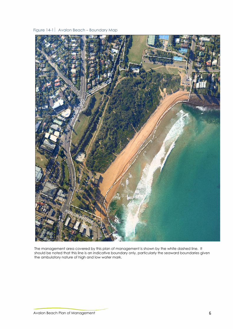
Figure 14-1 Avalon Beach – Boundary Map
The management area covered by this plan of management is shown by the white dashed line. It should be noted that this line is an indicative boundary only, particularly the seaward boundaries given the ambulatory nature of high and low water mark.
Avalon Beach Plan of Management 7
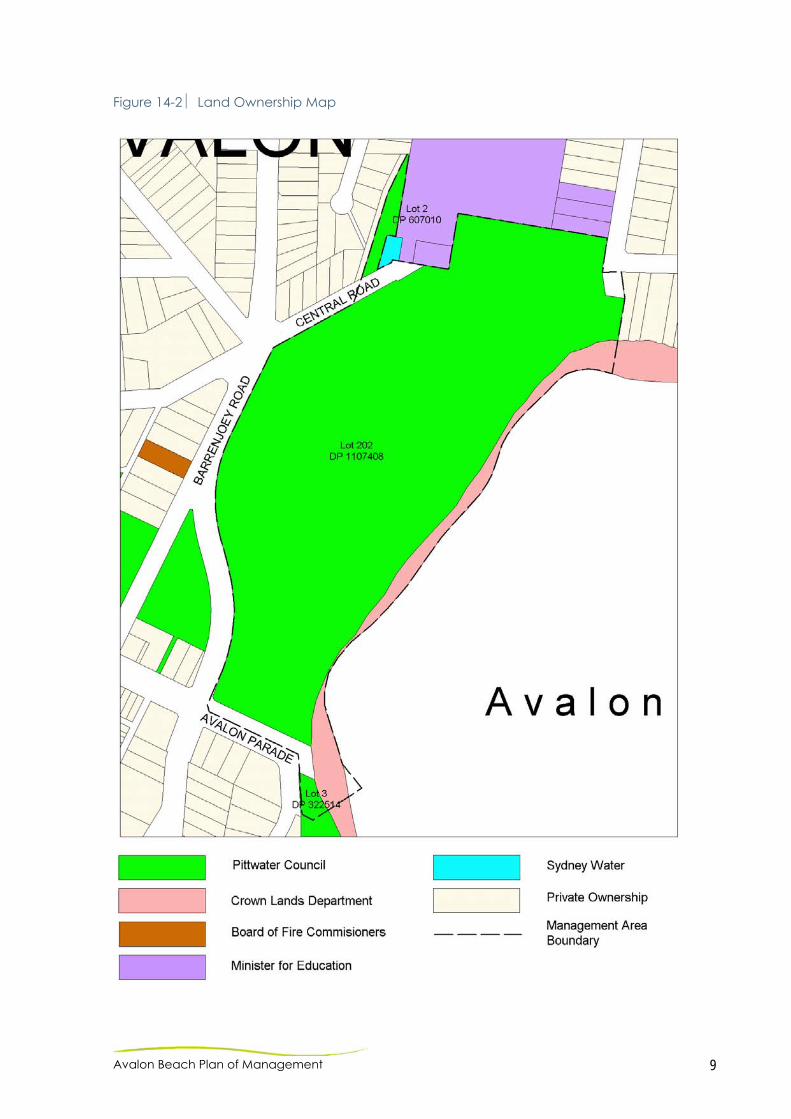
14.2 LAND TENURE, ADJOINING LANDHOLDINGS AND LAND CATEGORISATION 14.2.1 LAND TENURE Refer Figure 14-2 for Ownership Map. Land and Property Management Authority land described as:- The sand area of Avalon Beach is vacant Crown Land reserved from sale or lease as contained in Regional Crown Reserve R1012329 (RCR). The RCR also contains the intertidal zone, rock pool (and submerged lands to the three nautical miles State territorial limits). Council owned land described as:-
- Lot 202 DP 1107408 - Lot 2 DP 607010 - Lot 3 DP 322514 (part of) - Road Reserve (part of) – Avalon Parade
14.2.2 ADJOINING LANDHOLDINGS The study area is zoned 6(a) Existing Recreation ‘A’ with a small section of Arterial Road Reservation (Zone 9(d)) along Barrenjoey Road from Old Barrenjoey Road to Central Road. The Adjoining zoning to the beach reserve is largely 2(a) Residential “A”. Other adjoining zonings include:-
- 3(a) General Business “A”. Avalon Beach is the only beach in Pittwater to adjoin a major commercial district/business centre;
- 5(a) Special Uses “A” (including Maria Regina Primary School, Barrenjoey High School, Barrenjoey Montessori School, fire-station and pumping station); and
- Local Road Reservation Refer Figure 14-3 for Zoning Map. 14.2.3 LAND CATEGORISATION Refer Figure 14-4 for Categorisation Map.
There is no statutory provision or requirement to categorise Crown land. In interests of an inclusive and holistic management approach the strip of Crown land which is located between the intertidal areas of the beach reserve has been included in a community land category in accordance with the majority of the beach. General Community Use - covers the Avalon Beach SLSC building and the amenities block located at North Avalon, the rockpool, the skate park and all of the carpark areas. Park – This category has been applied to the areas of open space generally enjoyed for passive recreation including the Avalon Beach
Avalon Beach Plan of Management 8
Reserve, shared path and associated areas and the Des Creagh Reserve. Natural Area (foreshore, watercourse) – These sub categories have been widely applied to the beach / dune area and the watercourse (Careel Creek) running through the reserve.
Avalon Beach Plan of Management 9
Figure 14-2 Land Ownership Map

Avalon Beach Plan of Management 10
Figure 14-3 Zoning Map

Avalon Beach Plan of Management 11
Figure 14-4 Categorisation Map

Avalon Beach Plan of Management 12
14.3 CURRENT USES OF AVALON BEACH 14.3.1 BUILDING AND RECREATION FACILITIES Avalon Beach SLSC Building is located on the beach frontage of South Avalon Beach and accommodates surf life saving facilities, storage, male / female showers and toilets, and community rooms / function facilities. The grassed area adjacent to the SLSC building includes seating, picnic settings, children’s play equipment, litter bins, bubblers, outdoor showers / taps and lighting. The Avalon Skate Park is located at the southern end of Avalon Beach and is an extremely popular facility with local youth. The shared path, known locally as the ‘Yellow Brick Road’ extends from the southern beach reserve road entry to North Avalon Beach and car park (Tasman Road). Des Creagh Reserve is located at the northern end of the beach. The reserve includes a car park (providing access to the Barrenjoey Montessori School and occasional access to Barrenjoey High School) and an open grassed area, which is popular for picnics, male and female toilets and an outdoor shower. The Avalon dunes form a protective natural barrier to the main beach. 14.3.2 ROCK POOL The rock pool, located at the southern end of Avalon Beach, is divided in two, to form a larger pool that is approximately 25m in length and a smaller shallow children’s pool that is approximately 7m in length. 14.3.3 VEHICULAR ACCESS AND PARKING Car parks are located at both the southern and northern ends of the beach – adjacent to Des Creagh Reserve and the SLSC building respectively. The car park at the northern end of the beach accommodates approximately 30 cars and is not line marked. The southern car park is surfaced and line marked adjacent to the SLSC building, accommodating approximately 35 cars. The lower section adjacent to the shared path and skate park is currently being formalised and sealed. Further to the north, informal parking areas are regularly used to ease parking overflow. This area is subject to drainage problems and conflict with existing tree and dune planting. Upgrades to the overflow parking area will be undertaken in the future as Stage 2 of the works. The parking areas are subject to a ‘Pay and Display’ vehicle parking payment system (Refer Section 5.3.2). This Plan of Management authorises the charging of parking fees in accordance with Council’s Policy No. 18 – ‘Parking – Issue of Annual Permits – Waiving of Annual Fees’ (as determined by Council) by automated ticketed parking systems.
Avalon Beach Plan of Management 13
14.4 LEASES, LICENCES AND OTHER ESTATES Refer Section 4.4 on Leases, Licences and other estates. 14.4.1 CURRENT The only lease currently applicable to Avalon Beach is between Council and Avalon Surf Life Saving Club for a period of 21 years from 19 July 1999 to 18 July 2020. This PoM authorises a lease between Council and the Avalon Surf Life Saving Club for the building excluding the proposed café, restaurant and public toilets/change room’s area. . This PoM authorises a lease with Council with separate arrangements for commercial tenants. Refer to Risk Management, section 14-5.4 for further details on leases and other arrangements.
14.4.2 PROPOSED This Plan of Management authorises the leasing, licensing or granting of any other estate over Avalon Beach for any commercial activity that results in a diverse range of recreational activities or an activity that is deemed to be of community benefit being provided in the area. Future proposed leases at Avalon Beach include, but do not preclude any future leases at this location;
Avalon Beach food & beverage outlets. The proposals: (i) will be consistent with the use of the open space for
recreational purposes; (ii) will enhance the public use of the open space; and (iii) be generally in accordance with the concept plans /
elevations and associated figures within this Plan of Management (refer 14.5.5)
Community use. Council may lease areas of the SLSC
building to community groups and associations. Proposals must be for the community benefit and may take the form of singular or recurrent bookings.
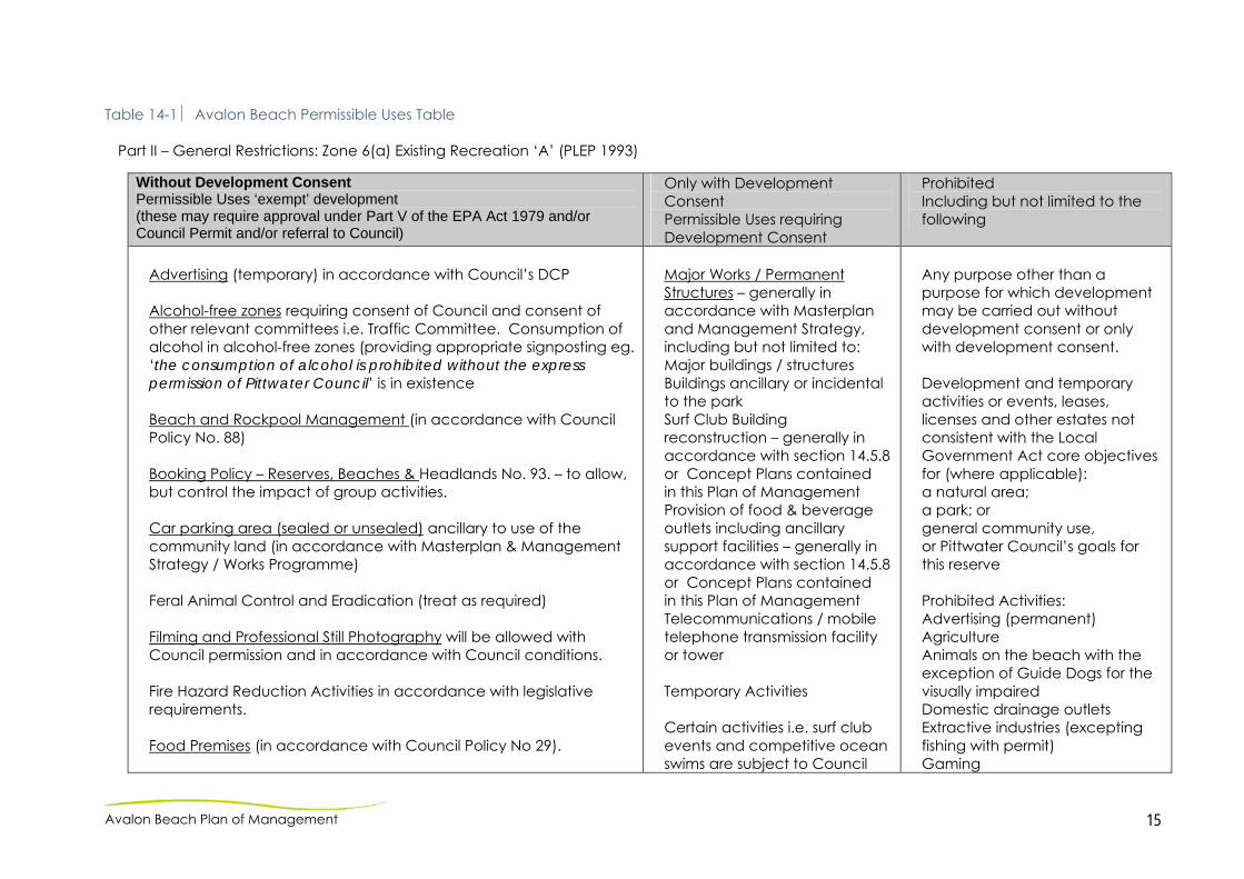
14.4.3 PERMISSIBLE USES TABLE The permissible and prohibited activities and developments in the subject reserve area have been detailed in Table 14-1 – Avalon Beach Permissible Uses Table. Development Application and Permit Procedures Any proposed uses or development and building works that are permitted only with Development Consent (consistent with the uses listed in the Permissible Uses Table) would be subject to the normal
Avalon Beach Plan of Management 14
Development Application process required by Council in accordance with the Environmental Planning and Assessment Act, 1979. Certain activities are subject to Council Permit approvals, in accordance with the relevant Council Policy. A summary of relevant Policy documents and the activities applicable, but not limited to, is detailed below:
Council Policy No 18 Parking – Issue of Annual Permits –
Waiving of Parking Fees: - Pay Parking Facilities
Council Policy No 24 – Professional Lifeguard Service: - Surf Life Saving Activities & Events
Council Policy No. 52 – Surf Life Saving Movement
- Minimum standards for surf club buildings
- Activities and administrative arrangements
- Identifying SLS / public buildings on beach reserves
Council Policy No 88 Beach & Rockpool Management Policy: - Beach and Beach Reserves - Beach Rockpools and Baths - Regulations for the use of Public Bathing Reserves - Beach Usage Fees - Management of Commercial Activities on Beach
Reserves – commercial filming, corporate functions, powerboat racing, fire works, surf contests
- Beach Compliance - Charges relating to the release of Impounded Equipment - Vehicles / Quad Bikes / All Terrain Vehicles on Beach
Reserves Council Policy No 93 Reserves, Beaches & headlands Booking
Policy: - Social, sporting, community and commercial events i.e.
weddings, charity events, fireworks - Lease Agreements
Council Policy No 98 Helicopter Landings on Council Owned and Controlled Property: - To define conditions for the use of helicopters undertaking
civil operations. - To control the environmental impacts and public risks
associated with helicopters
Council Policy No 129 Signs - Council’s Facilities: - Determine appropriate signage - Manage risks and minimise exposure to public liability
Avalon Beach Plan of Management 15
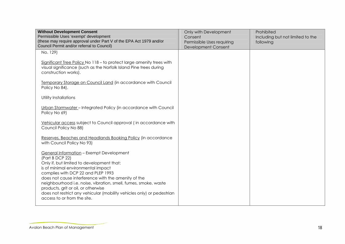
Table 14-1 Avalon Beach Permissible Uses Table Part II – General Restrictions: Zone 6(a) Existing Recreation ‘A’ (PLEP 1993)
Without Development Consent Permissible Uses ‘exempt’ development (these may require approval under Part V of the EPA Act 1979 and/or Council Permit and/or referral to Council)
Only with Development Consent Permissible Uses requiring Development Consent
Prohibited Including but not limited to the following
Advertising (temporary) in accordance with Council’s DCP Alcohol-free zones requiring consent of Council and consent of other relevant committees i.e. Traffic Committee. Consumption of alcohol in alcohol-free zones (providing appropriate signposting eg. ‘the consumption of alcohol is prohibited without the express permission of Pittwater Council’ is in existence Beach and Rockpool Management (in accordance with Council Policy No. 88) Booking Policy – Reserves, Beaches & Headlands No. 93. – to allow, but control the impact of group activities. Car parking area (sealed or unsealed) ancillary to use of the community land (in accordance with Masterplan & Management Strategy / Works Programme) Feral Animal Control and Eradication (treat as required) Filming and Professional Still Photography will be allowed with Council permission and in accordance with Council conditions. Fire Hazard Reduction Activities in accordance with legislative requirements. Food Premises (in accordance with Council Policy No 29).
Major Works / Permanent Structures – generally in accordance with Masterplan and Management Strategy, including but not limited to: Major buildings / structures Buildings ancillary or incidental to the park Surf Club Building reconstruction – generally in accordance with section 14.5.8or Concept Plans contained in this Plan of Management Provision of food & beverage outlets including ancillary support facilities – generally in accordance with section 14.5.8or Concept Plans contained in this Plan of Management Telecommunications / mobile telephone transmission facility or tower Temporary Activities Certain activities i.e. surf club events and competitive ocean swims are subject to Council
Any purpose other than a purpose for which development may be carried out without development consent or only with development consent. Development and temporary activities or events, leases, licenses and other estates not consistent with the Local Government Act core objectives for (where applicable): a natural area; a park; or general community use, or Pittwater Council’s goals for this reserve Prohibited Activities: Advertising (permanent) Agriculture Animals on the beach with the exception of Guide Dogs for the visually impaired Domestic drainage outlets Extractive industries (excepting fishing with permit) Gaming

Avalon Beach Plan of Management 16
Without Development Consent Permissible Uses ‘exempt’ development (these may require approval under Part V of the EPA Act 1979 and/or Council Permit and/or referral to Council)
Only with Development Consent Permissible Uses requiring Development Consent
Prohibited Including but not limited to the following
Helicopter landings if consistent with the core objectives of the park and with the General Manager of Council’s approval (in accordance with Council Policy No 98) Lease Agreements (in accordance with Council Policy No Liquor Licensing Applications (in accordance with Council Policy 175). Maintenance / minor works – in accordance with the Masterplan & Management Strategy / Works Programme, including but limited to the following: bush regeneration and land / habitat restoration works (including temporary access and storage of materials for work, minor excavation & levelling, grading, installation of protective fencing and weed removal) children’s playground equipment and structures dune stabilisation and foreshore protection measures earthworks to construct structures (including filling, levelling, grading and topdressing) fencing including security, childproof, protective and temporary fencing multi-use pathways and tracks (other than for motor vehicles) footpaths, cyclepaths, boardwalks, minor footbridges, steps, ramps land restoration works, including mounding landscaping works, including garden beds, laying turf and re-turfing lighting of reserve, including floodlighting of beach areas for beach related activities drainage, stormwater, erosion and sediment control works park furniture i.e. seating, bins, shade structures, outdoor showers and shelters
approval and Permits. A D.A is required when the:
number of participants and / or spectators on any one-day of an event exceeds 2000;
activities occur outside the period of 6.30am to 11.30pm; and
activities or temporary facilities occur over a total of more than 14 continuous days
Obstructing access or leaving goods in dangerous condition Private alienation or encroachment onto the reserve Private vehicular access to adjoining lands Recreational motor vehicles, including four-wheel driving, motorbike or trail bike riding, or similar, other than use for surf life saving and filming on a short term basis (in accordance with Council Policy No 88) Residential Storage of watercraft or equipment below Mean High Water Mark (MHWM) Unauthorised dumping of refuse including building materials, soil, fill, garden wastes and the like (other than importing of fill for permitted works) Vegetation removal not in accordance with Council’s Tree Preservation and Management Order, or this Plan of Management. Avalon Beach Reserve and Des Creagh Reserve are Alcohol Prohibited Areas – Evening Restricted Only 8pm to 8am.

Avalon Beach Plan of Management 17
Without Development Consent Permissible Uses ‘exempt’ development (these may require approval under Part V of the EPA Act 1979 and/or Council Permit and/or referral to Council)
Only with Development Consent Permissible Uses requiring Development Consent
Prohibited Including but not limited to the following
viewing platforms / decks Overflow vehicle parking on a temporary basis for special events, large film shoots, etc. Professional Lifeguard Service No 24. Recreational equipment hire eg. Bicycles, non-powered watercraft, umbrellas, banana chairs, locker storage equipment, etc. Temporary activities require a casual booking or permit from Council, or a licence under the Crown Lands Act 1989. Note: certain activities i.e. Surf Club Events & Competitive Ocean Swims may be subject to relevant authority approvals. Council Permit approval subject to temporary activities satisfying all of the following criteria: number of participants and / or spectators on any one-day of an event does not exceed 2000; activities do not occur outside the period of 6.30am to 11.30pm; and activities or temporary facilities do not occur over a total of more than 14 continuous days Tourism in Pittwater (in accordance with Council Policy No. 21). Pay Parking Facilities (in accordance with Council Policy No 18) Risk Management for Coastal Public Buildings Assets in Pittwater (in accordance with Policy No 186) Signage – compliance, directional, interpretive, identification and safety (in accordance with Council Signs – Council Facilities Policy
Part of Avalon Beach Reserve is contained within the Alcohol Free Zones (effective from 1 October 2009 until 30 September 2013). See Appendix 2. Note: The building occupied by Avalon Beach Surf Life Saving Club is excluded from the Alcohol Prohibited Area.
Avalon Beach Plan of Management 18
Without Development Consent Permissible Uses ‘exempt’ development (these may require approval under Part V of the EPA Act 1979 and/or Council Permit and/or referral to Council)
Only with Development Consent Permissible Uses requiring Development Consent
Prohibited Including but not limited to the following
No. 129) Significant Tree Policy No 118 – to protect large amenity trees with visual significance (such as the Norfolk Island Pine trees during construction works). Temporary Storage on Council Land (in accordance with Council Policy No 84). Utility Installations Urban Stormwater – Integrated Policy (in accordance with Council Policy No 69) Vehicular access subject to Council approval ( in accordance with Council Policy No 88) Reserves, Beaches and Headlands Booking Policy (in accordance with Council Policy No 93) General Information – Exempt Development (Part B DCP 22) Only if, but limited to development that: is of minimal environmental impact complies with DCP 22 and PLEP 1993 does not cause interference with the amenity of the neighbourhood i.e. noise, vibration, smell, fumes, smoke, waste products, grit or oil, or otherwise does not restrict any vehicular (mobility vehicles only) or pedestrian access to or from the site.

Avalon Beach Plan of Management 19
14.5 PROPOSED IMPROVEMENTS 14.5.1 MASTERPLAN The attached Masterplan (refer Figure 14-5) for Avalon Beach has been developed to illustrate the works and improvements to the beach and surrounds that are required to address key management issues and objectives. Specific improvement works have been described in greater detail. Note A community working party will be established to provide feedback to Council staff and the surf club on the detailed design of the amenities relating to the restaurant prior to the DA being lodged for the proposed restaurant. The resolution from the Council meeting on 3 December 2012 stated that “. . . Council authorise the expenditure of funds for the construction of this project, subject to the confirmation of the grant funding being confirmed.”

Avalon Beach Plan of Management 20
Figure 14-5 Avalon Beach – Masterplan

Avalon Beach Plan of Management 21
14.5.2 AVALON DUNES The dunes are maintained by Council through bush regeneration contractors with current funding of $16,000 a year. Between 1989 and 2007, a group of volunteers, now called the Friends of Avalon Dunes Dunecare group, undertook the restoration of the dunes. The Friends have recently recommenced work. Their aim is to stabilise, weed and regenerate / revegetate with local dune plant species to increase biodiversity and ecosystem resilience. Considering the history of the site, the technical skills of the Friends and the good work that has been achieved to date, the most important management strategy is to promote good communication and a well coordinated approach between the Friends, contractors and Council, particularly in relation to the weeds - where, what, why and how the various teams work throughout the dunes. Apart from weeds, the other most concerning issue is damage by youth who build bases / camps and drag sofas into the dunes. This is a cultural problem that is best addressed through the promotion of organised sport and recreational activities. Team based activities teach responsibility, promote social skills and burn excess energy. Other strategies include youth education through interpretative signage and school visits. Young people could also be encouraged to form a volunteer working group for dune restoration work. Council could also reduce the time items are left out before collection dates for kerb-side clean up to reduce the availability of materials. A designated youth area at the edge of the dunes could also be investigated in the longer term. This could provide Council with a negotiating tool in order to contain and monitor activities (This option is not supported by the Friends).
Specific management works include:
prepare a works program for the dune system and surrounds; promote the Friends through signage and on Council’s
website; promote communication and a coordinated approach
between the Friends, contractors and Council; replace the fencing around the parameter of the dunes; remove and treat weed species in accordance with best
practice; supplementary planting of local coastal vegetation; maintain the main access tracks through the dunes, but close
the middle access track through the dunes; At the northern end of the beach, there are three tracks,
close two tracks and retain one, Install interpretative signage where needed to discourage
people from walking on the plants – integrate signage into existing elements rather than using dominate signs on posts where possible;
restore area adjacent to Barrenjoey Montessori School and incorporate into main dune extent to consolidate management regimes;

Avalon Beach Plan of Management 22
establish a landscape ‘buffer’ of local coastal native plant species to north, west and southern interfaces. Edge treatment to reduce weed encroachment from managed amenity areas;
a viewing deck is proposed to be built in an area of the dunes for SLSC members and lifeguards to view the beach; and provide interpretative signage for dunes.
14.5.3 SOUTHERN CARPARK AND YELLOW BRICK ROAD Avalon Beach is a popular destination during the summer months. At these times, vehicle access and parking is congested. The previous 2007 plan of management proposed alleviating congestion by formalising the access drive and parking. Stage 1 works have recently been carried out (Refer to Figure 14-6). This is in accordance with the initial concept sketch. Works include:
two-way vehicular access driveway with turning circle at the northern section to alleviate current traffic congestion;
formalise parking bays (mix of perpendicular and parallel parking), type dependent on location;
resurface (reseal); parking bay demarcation; ‘wheel stop’ barriers / bollards (where required); footpath to improve access from Barrenjoey Road to the
beach; existing lighting has been integrated into new design; landscaping; and investigate extending the Yellow Brick Road, perhaps as part
of the creek-line corridor.

Avalon Beach Plan of Management 23
Figure 14-6 Southern Car Park – Recent works to formalise access drive and parking

Avalon Beach Plan of Management 24
14-5.4 OVERFLOW PARKING AREA – STAGE 2 Overflow parking is currently available towards the north of the new formalised access road. Overflow parking is necessary during peak periods, particularly during Nipper events, carnivals and surf competitions. Stage 2 proposes to formalise this area using road base to provide a low-key functional surface. The access road is single lane with parallel parking for minimal impact on the adjoining sand dunes. (Refer to Figure 14-7).
one-way access road with turning circle at the northern end; parallel parking to retain maximum dune vegetation; revegetate dune edge (currently vegetation in this area is
over-mature); overhead lighting to illuminate access drive and footpaths
along the entire length of the road; and tree planning.

Avalon Beach Plan of Management 25
Figure 14-7 Overflow parking – proposed works Stage 2.

Avalon Beach Plan of Management 26
14-5.5 RECREATIONAL AREA – SOUTH AVALON Proposed works include:
install additional park furniture; upgrade footpath connection from Barrenjoey Road bus stop
to Avalon Beach and Surf Life Saving Club / community facilities;
upgrade of playground area; improve eroded slope surrounds, incorporating ground
stabilisation , steps, decking, seating and shade provision (the seating will provide a turf surface, rather than concrete or stone);
undertake cliff line stabilisation work in accordance with geotechnical recommendations;
install sandstone terrace seating with turf surface (not sandstone);
signage; protection of kiosk footings and interpretative signage; and landscaping. (Refer to Figure 14-8)
14-5.6 DES CREAGH RESERVE & PARKING AREA - NORTH AVALON
Proposed works include:
stabilise the sand dune; re-fence the dune; install a timber deck; stabilise the main track leading to the beach; close excess tracks to the beach; retain the lawn behind the dune for recreational uses; consider installing a small playground in the longer term; seal and line mark the parking area; and address vandalism.
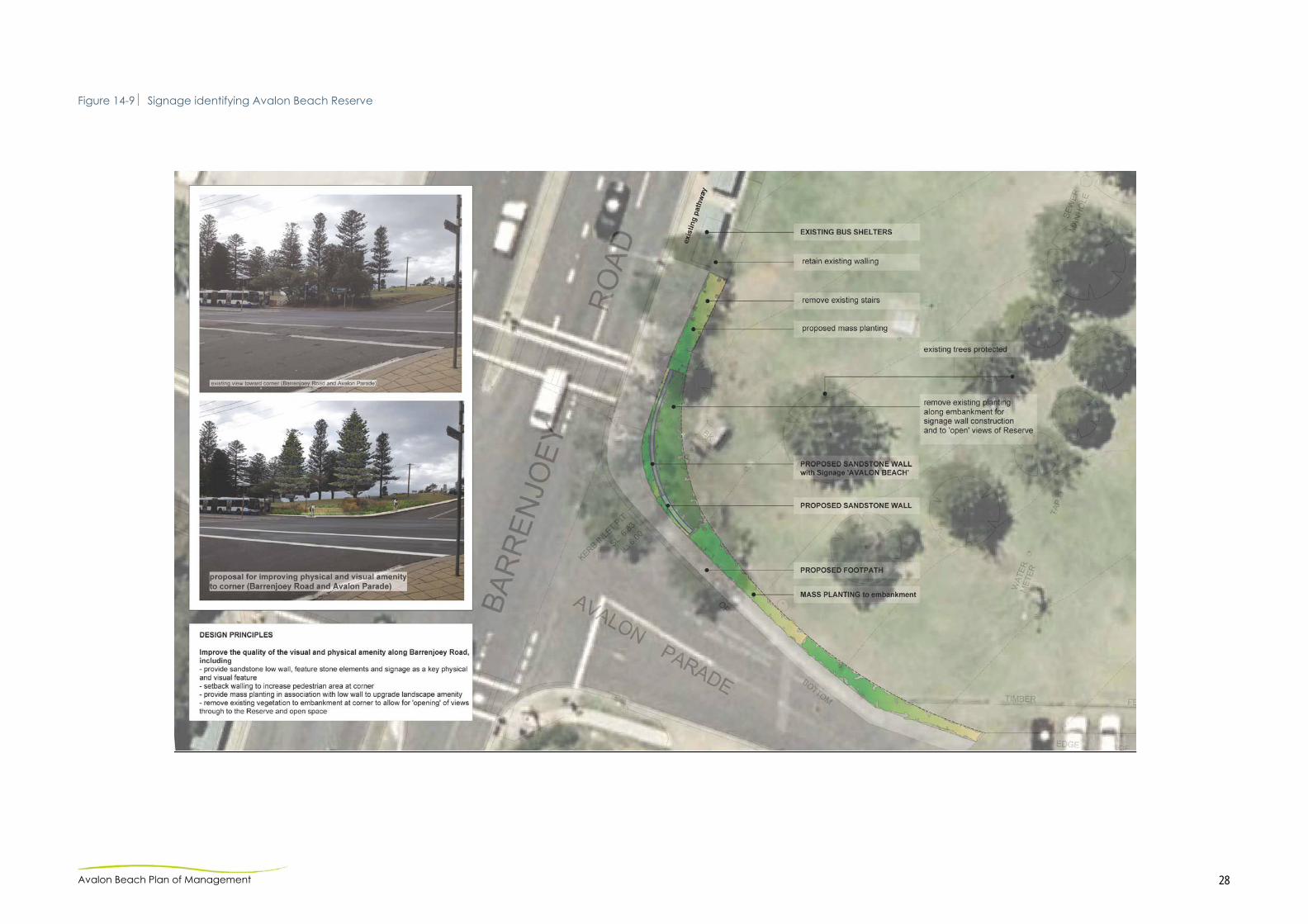
14-5.7 SENSE OF PLACE
Avalon Beach Reserve will be landscaped as sensitively as possible to enable the natural landscape to dominate. Principles:
the proposed recreational facilities – playground and picnic area, will be contained within the small section of the reserve as shown in the Masterplan (Refer to Figure 14-8);
the majority of the Reserve will be green, open space; vegetation will be locally native species where possible; plantings will consider coastal views and security (open
enough to prevent people hiding behind bushes; and a sign with the reserve name will be considered. (Refer to
Figure 14-9).

Avalon Beach Plan of Management 27
Figure 14-8 Avalon Beach Reserve – Landscape Plan
Avalon Beach Plan of Management 28
Figure 14-9 Signage identifying Avalon Beach Reserve

Avalon Beach Plan of Management 29
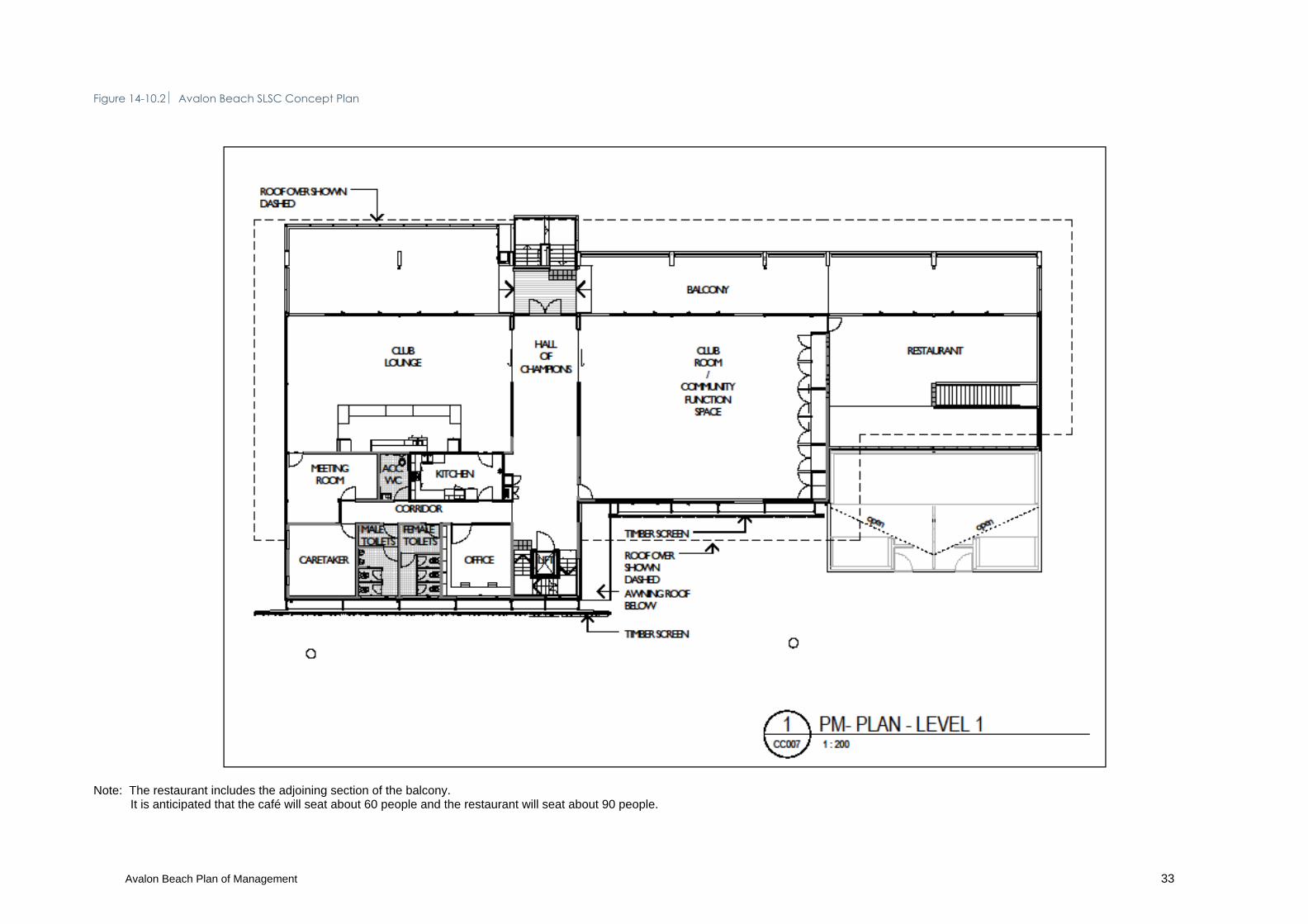
14-5.8 PROPOSED SURF CLUB BUILDING
The existing building is generally in poor condition, subject to continual repairs and increasingly outmoded for the current and future usages. Storage space for rescue and training equipment is at a premium and specific areas of the building do not comply with current Building Code of Australia (BCA) requirements. A proportion of the building is leased by Surf Life Saving Australia (refer 14.4) while the southern end of the building accommodates the Avalon Beach public facilities (showers, change area and toilets). A development application was lodged in 2011 for a new building in accordance with the 2007 Plan of Management. The Development Approval addressed many issues including water sustainability (water saving and disposal to approved discharge), consideration of the Disability Discrimination Act 1992 and Council Policy. The current proposal provides for the addition of a restaurant on the first floor at the southeastern corner of the building (refer to Figures 14-10.1 to 14-10.4. The building as proposed retains the 2007 footprint with improved aesthetics and functions, including:
storage rooms will open both sides – from access road to beach to provide patrol gear and trailers with through access;
improved organisation for service rooms - patrol and first aid;
Hall of Champions to showcase trophies and awards; first floor flexibility with sliding panels between rooms (join or
separate depending on function). terrace overlooking the beach - 4m x 6m with roof and
clear blinds for wind protection; disabled access – lift; caretaker room with access to Club kitchen and bathroom; several toilet areas; and transparent roof over the shower and change room
downstairs for natural light and sun; architect to review amenities for restaurant during the
detailed design stage.
Sustainable Initiatives During construction stage
Large canopy roof to shade glazing. Natural ventilation and ceiling fans (no air conditioning). High performance glazing. Gas heating. High rating insulation for walls and roof. LED lighting. Sun screens on the western side of the building.

Avalon Beach Plan of Management 30
Sustainable material selections including timber and materials salvaged from existing building.
Fibre cement cladding in clear finish for low embodied energy.
Solar panels. Underground water tank to the north of the building.
Equity of Use
The Avalon Beach Surf Life Saving Club consists of about 1,000 members who will enjoy the new facility.
The facility will provide improved conditions for rescue service operators.
The community rooms will be available for hire and the improved facilities will benefit all users.
The Club currently encourage the community to use the existing facility through a website booking system. The Club will continue to do this to ensure the facility is available to the wider community. Current uses include regular classes such as yoga and drama and special occasions such as birthdays (not 18th and 21st), weddings, wakes and corporate events.
The building includes a lift for disabled access. Coastal Management A Coastal Protection Works Management Plan has been obtained for the deep pile foundations including strategies to manage ongoing access to the beach, public liability risks, coastal protection works and any restoration of the beach and adjacent land. (Refer to Figure 14-11)
Avalon Beach Plan of Management 31
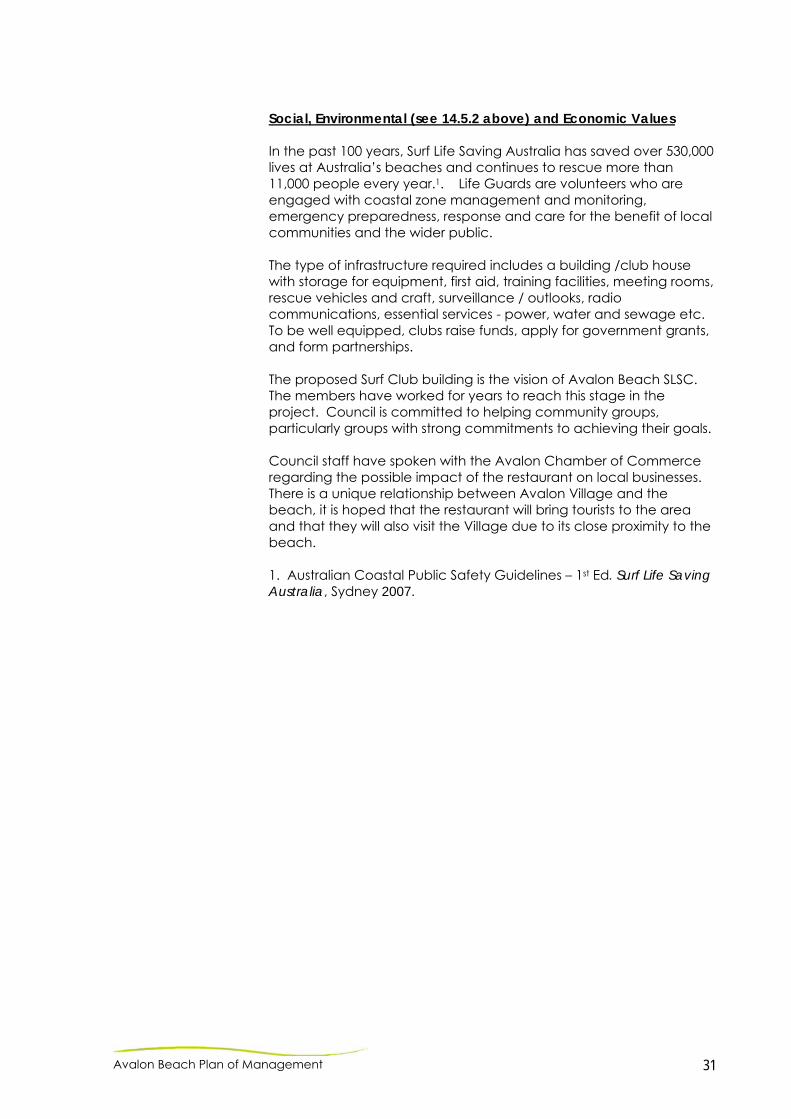
Social, Environmental (see 14.5.2 above) and Economic Values In the past 100 years, Surf Life Saving Australia has saved over 530,000 lives at Australia’s beaches and continues to rescue more than 11,000 people every year.1. Life Guards are volunteers who are engaged with coastal zone management and monitoring, emergency preparedness, response and care for the benefit of local communities and the wider public. The type of infrastructure required includes a building /club house with storage for equipment, first aid, training facilities, meeting rooms, rescue vehicles and craft, surveillance / outlooks, radio communications, essential services - power, water and sewage etc. To be well equipped, clubs raise funds, apply for government grants, and form partnerships. The proposed Surf Club building is the vision of Avalon Beach SLSC. The members have worked for years to reach this stage in the project. Council is committed to helping community groups, particularly groups with strong commitments to achieving their goals. Council staff have spoken with the Avalon Chamber of Commerce regarding the possible impact of the restaurant on local businesses. There is a unique relationship between Avalon Village and the beach, it is hoped that the restaurant will bring tourists to the area and that they will also visit the Village due to its close proximity to the beach. 1. Australian Coastal Public Safety Guidelines – 1st Ed. Surf Life Saving Australia, Sydney 2007.

Avalon Beach Plan of Management 32
Figure 14-10.1 Avalon Beach SLSC Concept Plan
Avalon Beach Plan of Management 33
Figure 14-10.2 Avalon Beach SLSC Concept Plan
Note: The restaurant includes the adjoining section of the balcony. It is anticipated that the café will seat about 60 people and the restaurant will seat about 90 people.
Avalon Beach Plan of Management 34
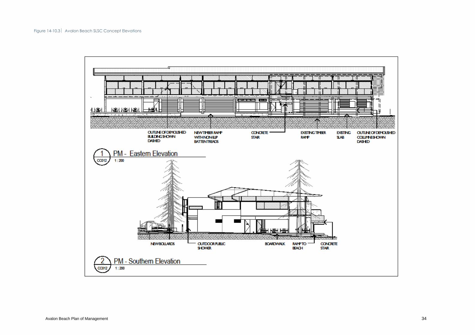
Figure 14-10.3 Avalon Beach SLSC Concept Elevations
Avalon Beach Plan of Management 35
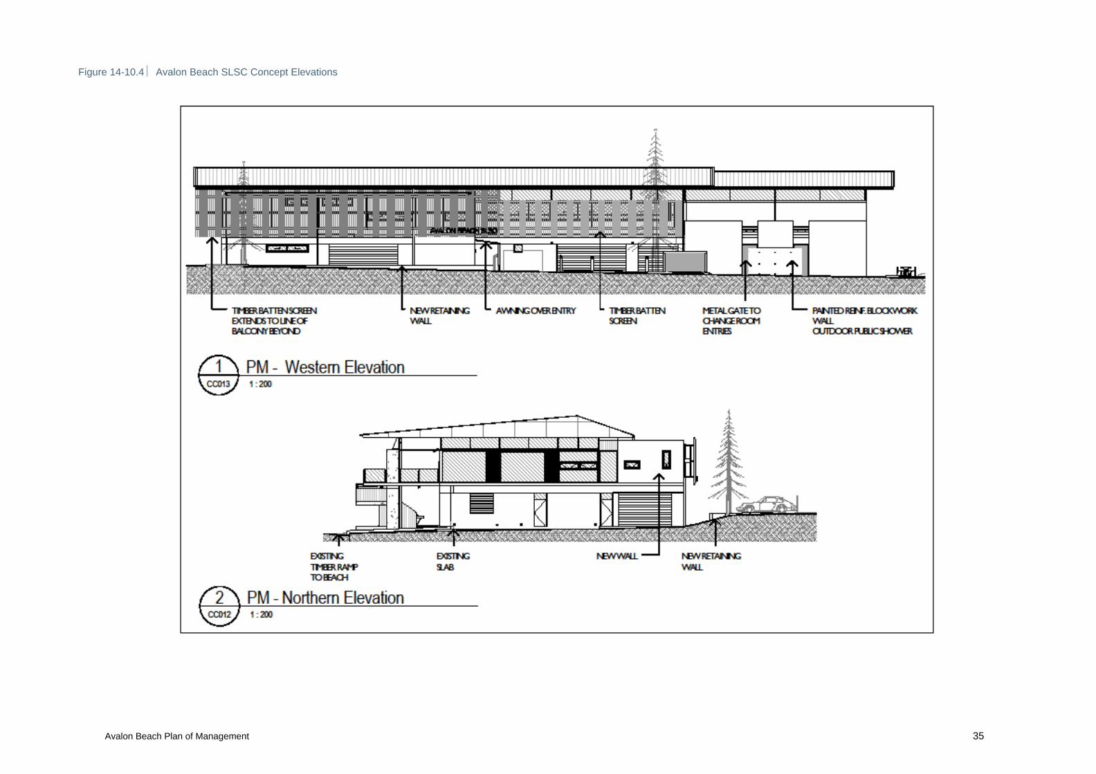
Figure 14-10.4 Avalon Beach SLSC Concept Elevations

Avalon Beach Plan of Management 36
Figure 14-11 Shore protection: low vegetated dunes – Illustrative sketch

Avalon Beach Plan of Management 37
14.6 WORKS PROGRAM FOR AVALON BEACH
The table below includes indicative costs only for implementation of the master plan. It should be noted that the commencement and completion of works identified in the master plan are dependent on Council resources and funding. Table 14-2 Avalon Beach Works Program
Area / Item
Approx. Cost
North Avalon Amenities Building General maintenance (approx. $3500 per year) – 5 year term $17,500 Amenities building refurbishment $60,000 Northern Car Park & Beach Access General improvements – line marking / road surface repair (reseal) $25,000 Picnic table installation (grassed terraces) – 1no $3,000 Stone steps installation – northern beach access (lower) $5,000 Incorporate small viewing platform & seating $50,000 -
$100,000 Des Creagh Reserve & Car Park General improvements – line marking / road surface repair (reseal) $60,000 Shade tree planting i.e. Banksia integrifolia (10-15no) $10,000 Rejuvenate existing carpark planting beds $3,000 New playground $200,000 New picnic furniture & supplementary reserve planting (shade trees) $15,000 Pathway Network Lighting installation (approx 5no) $90,000 Re-grade and re-turf (adj. pumping station) / new tree planting $8,000 Extension of route in accordance with Pittwater Walks & Rides Strategy Masterplan (June 2005)
$150,000
Avalon Dunes Maintenance – fencing / weed treatment / supplementary planting $20,000 Expansion of rear dune vegetation extent (adj. Barrenjoey Montessori School)
$20,000
Careel Creek General maintenance – footbridges $5,000 General maintenance - Treatment of creek line consistent with Careel Creek Floodplain Risk Management Plan (Dec 2002) (approx. $5000 per year) – 5 year term
$25,000
Ongoing restoration / planting of riparian corridor (approx $10,000 per year)
$50,000
Investigate ‘Naturalisation’ of concrete channel (with regard to Careel Creek Floodplain Risk Management Plan / Study (Dec 2002) – Option E: Restoration of concrete lined section. Prepare Feasibility Study.
$50,000
Western Reserve Area Shade tree planting to recreation / court areas (approx 10-15no) $10,000 Street tree planting: Barrenjoey Road (approx 10-15no) $15,000 Skateboard Park General improvements $20,000 Refurbishment – new seating / vegetation enhancement / fencing $10,000 Central Reserve – Occasional Use Car Park Implement parking layout / access road definition / landscaping (hard surface treatment)
$70,000
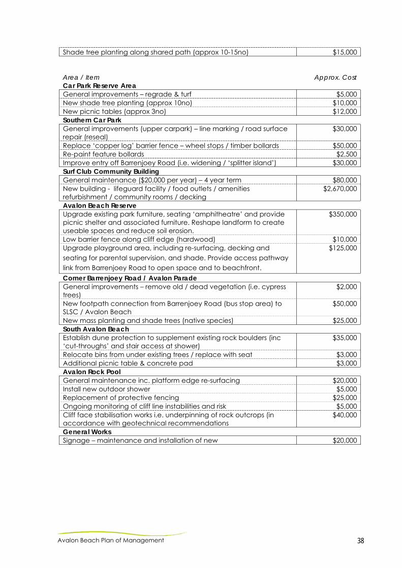
Avalon Beach Plan of Management 38
Shade tree planting along shared path (approx 10-15no) $15,000 Area / Item
Approx. Cost Car Park Reserve Area General improvements – regrade & turf $5,000 New shade tree planting (approx 10no) $10,000 New picnic tables (approx 3no) $12,000 Southern Car Park General improvements (upper carpark) – line marking / road surface repair (reseal)
$30,000
Replace ‘copper log’ barrier fence – wheel stops / timber bollards $50,000 Re-paint feature bollards $2,500 Improve entry off Barrenjoey Road (i.e. widening / ‘splitter island’) $30,000 Surf Club Community Building General maintenance ($20,000 per year) – 4 year term $80,000 New building - lifeguard facility / food outlets / amenities refurbishment / community rooms / decking
$2,670,000
Avalon Beach Reserve Upgrade existing park furniture, seating ‘amphitheatre’ and provide picnic shelter and associated furniture. Reshape landform to create useable spaces and reduce soil erosion.
$350,000
Low barrier fence along cliff edge (hardwood) $10,000 Upgrade playground area, including re-surfacing, decking and seating for parental supervision, and shade. Provide access pathway link from Barrenjoey Road to open space and to beachfront.
$125,000
Corner Barrenjoey Road / Avalon Parade General improvements – remove old / dead vegetation (i.e. cypress trees)
$2,000
New footpath connection from Barrenjoey Road (bus stop area) to SLSC / Avalon Beach
$50,000
New mass planting and shade trees (native species) $25,000 South Avalon Beach Establish dune protection to supplement existing rock boulders (inc ‘cut-throughs’ and stair access at shower)
$35,000
Relocate bins from under existing trees / replace with seat $3,000 Additional picnic table & concrete pad $3,000 Avalon Rock Pool General maintenance inc. platform edge re-surfacing $20,000 Install new outdoor shower $5,000 Replacement of protective fencing $25,000 Ongoing monitoring of cliff line instabilities and risk $5,000 Cliff face stabilisation works i.e. underpinning of rock outcrops (in accordance with geotechnical recommendations
$40,000
General Works Signage – maintenance and installation of new $20,000
Avalon Beach Plan of Management 39
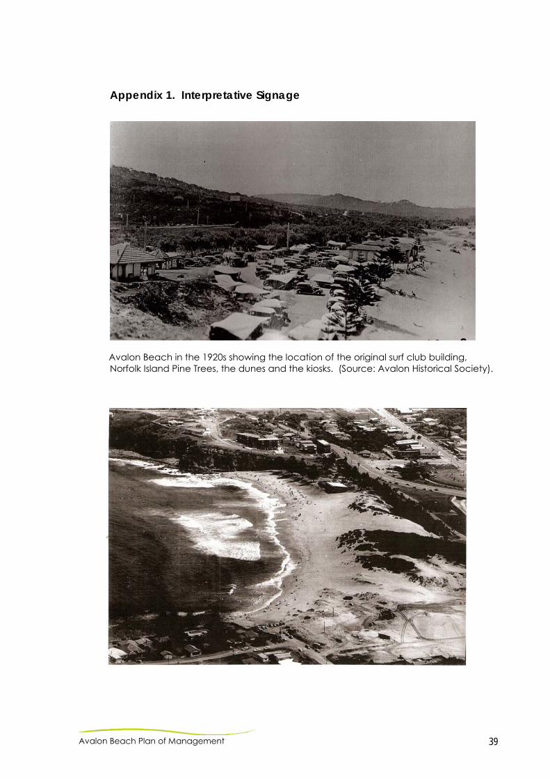
Appendix 1. Interpretative Signage
Avalon Beach in the 1920s showing the location of the original surf club building, Norfolk Island Pine Trees, the dunes and the kiosks. (Source: Avalon Historical Society).
Avalon Beach Plan of Management 40
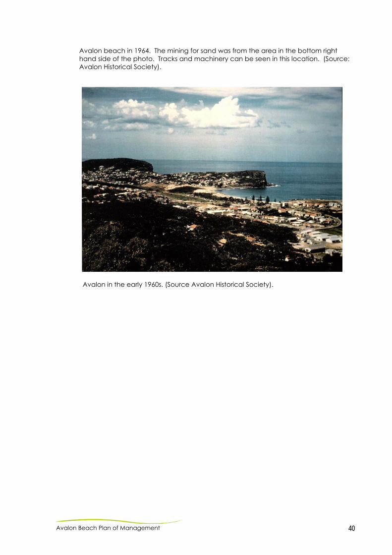
Avalon beach in 1964. The mining for sand was from the area in the bottom right hand side of the photo. Tracks and machinery can be seen in this location. (Source: Avalon Historical Society).
Avalon in the early 1960s. (Source Avalon Historical Society).

Avalon Beach Plan of Management 41
Appendix 2. Alcohol Free Zones within Avalon Beach Reserve and Surrounds
Avalon Beach Plan of Management 42
Appendix 3. Avalon Beach – surfing history This information was contained in a submission received from a resident during the exhibition period: What is not apparent and included is the historical background that is essential to the beach culture of the area/suburb. While there is not many significant events that would apply to this area, there is a major one which is of great significance to Avalon Beach. It is widely documented to be the first place in Australia where modern malibu surfboard riding was displayed in November 1956 and the significance of this event to Australian coastal culture is undeniable. This eventuated from the American and Hawaiian lifesavers visiting Avalon to compete in the local carnival when they first arrived for the demonstration sport with the Olympics. From this event the lifesaving movement in England established itself with the surfboard industry also being started due to 4 lifesavers from the club going over for lifeguard positions. The rubber ducky also could be said to have been a result of that day. A very successful commemoration of this event was conducted between the board riding and surf lifesaving communities 50 years later in the Surf Club. This has assisted with the very good relationships between all the surfing fraternities at the beach. It was noted at that time that there should be a monument that can be placed in a conspicuous place that allows for this proud part of our history to be displayed for the future generations. I ask that you present this for inclusion in the POM....the opportunity has now presented itself and you would agree it is vital that it is not lost.

lt8A0172mjp_gwb211212 - CPWMP 1
Mark Eriksson Pittwater Council
PO Box 882
MONAVALE NSW 1660
Our reference: lt8A0172mjp_gwb211212 - CPWMP
Date: 21 December 2012
Subject: AVALON SURF LIFE SAVING CLUB
COASTAL PROTECTION WORKS MANAGEMENT PLAN
Dear Mark
It is understood that a Coastal Protection Works Management Plan (CPWMP) for Avalon SLSC is
required to address the management of beach access, beach amenity, public liability and
maintenance issues related to the installation of deep pile foundations associated with the proposed
refurbishment and redevelopment. This plan will be included as a subplan of the Avalon Beach
Reserve Plan of Management (PoM) when it is next reviewed. This PoM is currently on public
exhibition until 4th February 2013 and includes consideration of the proposed Avalon SLSC
refurbishment and redevelopment works.
Royal HaskoningDHV (RHDHV) have been engaged to prepare the CPWMP, which is provided in
Attachment A. Should you require any additional information, please not hesitate to contact us.
Yours faithfully
HASKONING AUSTRALIA
Greg Britton
Director
Suite 3, Level 3
100 Walker Street
NORTH SYDNEY NSW 2060
+61 (0)2 8854 5000
+61 (0)2 9929 0960
www.royalhaskoningdhv.com
ABN 66 153 656 252
HASKONING AUSTRALIA
MARITIME & WATERWAYS

lt8A0172mjp_gwb211212 - CPWMP 2
Attachment A
Avalon SLSC Coastal Protection Works Management Plan

AVALON SURF LIFE SAVING CLUB
COASTAL PROTECTION WORKS MANAGEMENT PLAN
Background
It is proposed to refurbish and redevelop the Avalon Surf Life Saving Club (SLSC) building over the
existing footprint. As a portion of the existing SLSC building is located seaward of the immediate
coastal hazard line and the building is entirely seaward of the 2060 and 2110 hazard lines, the
redevelopment of the building in its current position requires underpinning of the structure with deep
piled foundations.
The installation of the proposed deep piled foundations requires the preparation of a Coastal
Protection Works Management Plan (CPWMP), which addresses the following issues for the life of
the development:
ongoing public access to and use of the beach in the vicinity of the surf club building;
management of public liability issues associated with the coastal protection works;
the maintenance of the coastal protection works; and,
arrangements for the restoration of the beach, or land adjacent to the beach, if any increased
erosion is caused by the presence of the works.
The management of these issues is outlined below.
Ongoing Public Access and Liability
Under normal conditions, public access to the beach following redevelopment of the SLSC building
would be provided by:
existing timber ramp;
new timber ramp (proposed);
existing path on northern side of SLSC building; and,
existing informal access over partially buried seawall structure and low level retaining wall to
the south of the SLSC building.
Management of public access and liability during and after storms should be considered in the context
of the position of the crest of any resultant erosion scarp in relation to the above access structures
and the deep piled foundations of the SLSC building. Management actions to be implemented under
the following scenarios are outlined below:
erosion scarp seaward of existing and new beach access ramps;
erosion scarp landward of existing and new beach access ramps but seaward of the SLSC
building foundations; and,
erosion scarp landward of SLSC building foundations.
Erosion scarp seaward of existing and new beach access ramps
In this situation, management of beach access and usage in the vicinity of the SLSC building would
be similar to that currently employed during and after storm events. This would include:
erection of ‘beach closed’ signs during dangerous surf conditions;
lifeguards on duty during storm events to inform the public of hazardous conditions and
discourage people from entering the ocean; and,
no additional specific restrictions on beach access.
Erosion scarp landward of existing and new beach access ramps but seaward of the SLSC building
foundations
In this situation, the existing beach access ramp at the northern end of the SLSC building would be
undermined. This ramp structure is not known to be founded at a depth below the expected storm
scour level and would be left unsupported if outflanked by an erosion scarp. Under this scenario, the
structure may fail and be broken apart under the action of waves.
The new beach access ramp would be supported on deep piled foundations and should remain
standing during an erosion event. However, the end of the ramp would be elevated above the eroded
beach profile and would be unsuitable for beach access.
The following management actions are to be employed during storms and the subsequent beach
recovery period:
erection of ‘beach closed’ signs during dangerous surf conditions;
lifeguards on duty during storm events to inform the public of hazardous conditions and
discourage people from entering the ocean;
removal of any debris from any failure of the existing beach ramp when safe to do so;
erection of temporary barricades across the entry points to the existing and new beach
access ramps;
provision of appropriate signage at both ramp access points indicating prohibited access;
beach access via existing path on northern side of SLSC building and over the foreshore to
the south of the SLSC building is retained for continued beach usage after dangerous surf
conditions subside and the beach is reopened; and,
undertaking of beach scraping and/or sand replenishment activities as soon as possible
following the storm erosion event to restore beach amenity and safe access (refer to
discussion of beach restoration below).
Erosion scarp landward of SLSC building foundations
In this situation, both of the beach ramps would be undermined and the erosion scarp would have
undercut the ground floor slab of the SLSC building, exposing its deep piled foundations and creating
a cavity beneath the building. This would also result in undercutting of the seaward edge of the beach
access path on the northern side of the SLSC building, creating an unsafe drop from the ground floor
level to the eroded beach level. A similar height differential would exist over the edge of the ground
floor slab along the seaward frontage of the SLSC building.
The cavity and exposed foundations beneath the SLSC building would present a potential hazard to
the public once the beach is reopened, particularly at high tides. Public access to the immediate area
around the seaward frontage of the SLSC building should be prohibited until beach levels are
restored.
The following management actions are to be employed during storms and the subsequent beach
recovery period:
erection of ‘beach closed’ signs during dangerous surf conditions;
lifeguards on duty during storm events to inform the public of hazardous conditions and
discourage people from entering the ocean;
removal of any debris from any failure of the existing beach ramp when safe to do so;

installation of a temporary barricade (with appropriate signage) across the beach access path
to the north of the SLSC building;
installation a temporary barricade (with appropriate signage) across the access path (adjacent
to the public toilets) to the paved area along the seaward frontage of the SLSC building;
installation of temporary fencing on the beach to enclose the area of exposed foundations
along the seaward frontage and sides of the SLSC building (when practicable and safe to do
so); and,
undertaking of beach scraping and/or sand replenishment activities as soon as possible
following the storm erosion event to restore beach amenity and safe access (refer to
discussion of beach restoration below).
Maintenance of Coastal Protection Works
Deep pile foundations to support the Avalon SLSC should be designed from a durability perspective
for occasional exposure to the marine environment, at those times of beach erosion and prior to
beach recovery, in accordance with Australian Standard AS 4997 Guidelines for Design of Maritime
Structures having regard to the life of the building. It would not be necessary to undertake a regular
maintenance program involving mechanical excavation around the piles, but the opportunity should
be taken to inspect the piles whenever they are exposed following storm events and to complete any
maintenance, if required.
Beach Restoration
The proposed foundation piles are not expected to exacerbate erosion in adjacent areas as they
would be spaced several metres apart, are relatively small in dimension relative to the scale of the
wave conditions and would act as an open structure allowing the transmission of wave energy to the
position of the retreating erosion scarp.
Notwithstanding, in the interests of restoring beach amenity and safe access and minimising public
liability risk, beach scraping and/or sand replenishment should be employed to restore the eroded
foreshore areas in the vicinity of the SLSC building as soon as possible after storms.
Beach scraping should be used to accelerate natural beach recovery and involves the movement of
relatively small to medium quantities of sand from the lower portion of the beach profile to rebuild the
upper beach profile, by mechanical means (typically using earthmoving equipment such as
bulldozers). Provided that low tide water levels allow sand to be accessed from the lower beach
profile, this practice could be employed adjacent to the SLSC building to return sand to exposed
foundation areas beneath the ground floor slab and restore beach amenity.
Beach access for plant and equipment should be available at the southern end of Avalon Beach
adjacent to the ocean pool, which is likely to be less affected by wave erosion. As access beneath
the ground floor slab of the SLSC building is likely to be limited by height restrictions and presence of
deep foundation piles, it is anticipated that beach scraping by large bulldozers would need to be
supplemented with pushing and placement of sand beneath the structure by smaller equipment such
as front end loaders and Bobcats.
Sand accessible from the lower portion of the beach profile could also be supplemented by
redistribution of sand from other adjacent areas of the beach using similar plant and equipment.