Pinellas County Recommended Revisions to … County Recommended Revisions to Geographic Response...
11
Pinellas County Recommended Revisions to Geographic Response Plan Maps Posted July, 2010 The following Recommended Revision Maps were submitted by Pinellas County Environmental Management staff on July 2, 2010. If the Deepwater Horizon oil spill impacts Pinellas County, the natural resource areas indicated on the Recommended Revision Maps—plus the areas indicated on the current set of Geographic Response Maps —will be considered for protection by the U.S. Coast Guard and partner agencies. The strategies used to protect environmentally sensitive areas will be based on the anticipated impact location, oil characteristics, weather, and water conditions.
Transcript of Pinellas County Recommended Revisions to … County Recommended Revisions to Geographic Response...

Pinellas County Recommended Revisions to Geographic Response Plan Maps
Posted July, 2010
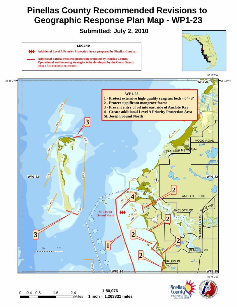
The following Recommended Revision Maps were submitted by Pinellas County Environmental Management staff on July 2, 2010. If the Deepwater Horizon oil spill impacts Pinellas County, the natural resource areas indicated on the Recommended Revision Maps—plus the areas indicated on the current set of Geographic Response Maps—will be considered for protection by the U.S. Coast Guard and partner agencies. The strategies used to protect environmentally sensitive areas will be based on the anticipated impact location, oil characteristics, weather, and water conditions.
XXX
!d(
WP1-231 - Protect extensive high-quality seagrass beds - 0’ - 3’2 - Protect significant mangrove forest3 - Prevent entry of oil into east side of Anclote Key4 - Create additional Level A Priority Protection Area - St. Joseph Sound North
4
31
2
2
2
22
3
0
1525
0
5450
4900
4650
4300
3700
1340
0
3450
2750
3900
2150
2200
2100
1700
1500
0
0
0
0
1500
ANCLOTE BLVD
ANCLOTE RD
N P
INE
LLA
S A
VE
STRAUBER MEMORIAL
MERES BLVD
MOOG ROAD
DIXIE HWY
CURLEW PL
WP1-23 WP1-22
WP1-24
WP1-21
WP1-2582�45’0"W
82�45’0"W
28�15’0"N 28�15’0"N
Pinellas County Recommended Revisions to Geographic Response Plan Map - WP1-23
�
Submitted: July 2, 2010
1:80,0761 inch = 1.263831 miles
0 0.8 1.6 2.40.4Miles
XXX
Additional natural resource protection proposed by Pinellas County.Operational and booming strategies to be developed by the Coast Guard.(shape file available on request)
Additional Level A Priority Protection Areas proposed by Pinellas County.
LEGEND
------------------------
St. Joseph Sound North

XXX
WP1-241 - Protect extensive high-quality seagrass beds - 0’ - 3’2 - Prevent entry of oil into Happy Bayou3 - Prevent entry of oil into Smith Bayou4 - Prevent entry of oil into Curlew Creek5 - Prevent entry of oil into Clearwater Harbor at Canal through Dunedin Causeway6 - Prevent entry of oil into Cedar Creek7 - Protect bird rookeries (2 islands)8 - Create additional Level A Priority Protection Area - St. Joseph Sound South
6
1 2
4
35
7
8
0
18750
17550
1850
1650
0
0
0
0
�«580
�«580
MAIN ST
OM
AHA
ST
BE
LCH
ER
RD
UNION ST
CURLEW RD
BR
OA
DW
AY B
AYS
HO
RE
BL
ALDERMAN RD
PATR
ICIA
AV
E
MICHIGAN BLVD
DO
UG
LAS
AV
ENEBRASKA AVE
SOLON AVE
NE
W Y
OR
K A
VE
NU
E
VIRGINIA AVE
WP1-24 WP1-25
WP1-26 WP1-2782�45’0"W
82�45’0"W
28�0’0"N 28�0’0"N
Pinellas County Recommended Revisions to Geographic Response Plan Map - WP1-24
�
Submitted: July 2, 2010
1:80,0761 inch = 1.263831 miles
0 0.8 1.6 2.40.4Miles
XXX
Additional natural resource protection proposed by Pinellas County.Operational and booming strategies to be developed by the Coast Guard.(shape file available on request)
Additional Level A Priority Protection Areas proposed by Pinellas County.
LEGEND
------------------------
St. Joseph Sound South

!d(
WP1-251 - Protect significant mangrove forest (Phillippe Park)2 - Prevent entry of oil into tidal creek3 - Prevent entry of oil into tidal creek within Mobbly Bayou Preserve4 - Prevent entry of oil into Bishop Creek and protectsignificant mangrove forest
3
2
14
0
15001350
950
1100
1000
700
600
0
0
1000
£�19
�«580
�«580
�«580
�«580�«580
")611
")611
US
19
SR 580
TAMPA ROAD
BE
LCH
ER
RD
CURLEW RD
EAST LAKE R
D
ENTERPRISE RD
ALDERMAN RD
RACE TRACK RD
MC
MU
LLE
N-B
OO
TH R
D
CO
UN
TRYW
AY B
LVD
MAIN ST
PATTERSON RD
PHIL
IPPE
PK
WY
LINEBAUGH AVE
FED
ER
AL
HW
Y
WEST LAKE R
D
NEBRASKA AVE
EVANS RD
LANSBROOK PARKWAY
NORTHSIDE DR
LAKE FRONT DRIVE
RIDGEMOOR BLVD
BELCHER RD
WP1-25
WP1-22
WP1-27
WP1-23
WP1-2682�45’0"W
82�45’0"W
28�0’0"N 28�0’0"N
Pinellas County Recommended Revisions to Geographic Response Plan Map - WP1-25
�
Submitted: July 2, 2010
1:80,4141 inch = 1.269153 miles
0 0.9 1.8 2.70.45Miles
XXX
Additional natural resource protection proposed by Pinellas County.Operational and booming strategies to be developed by the Coast Guard.(shape file available on request)
Additional Level A Priority Protection Areas proposed by Pinellas County.
LEGEND
------------------------

s
WP1-261 - Prevent entry of oil into Stevenson Creek2 - Prevent entry of oil into McKay and Church Creeks3 - Protect significant mangrove forest (Largo Intracoastal Park)4 - Prevent north/south flow of oil into Clearwater Harbor or the Narrows at Indian Rocks Bridge
1
4
2
3
0
0
£�19
�«688
�«60�«651
�«60
�«60
�«60
DRUID RD
DREW ST
GU
LF B
LVD
UNION ST
LAK
E A
VE
BELLEAIR ROAD
INDI
AN R
OCK
S RO
AD
EAST BAY DR
HIG
HLA
ND
AV
EN
UE
KE
EN
E R
D/C
R 1
S M
ISS
OU
RI A
VE
SE
MIN
OLE
BLV
DLAKEVIEW ROAD
BELLAIR CAUSEWAY
SUNSET POINT ROAD
WALSINGHAM RD
113T
H S
T
ROSERY RD
WILCOX RD
N H
ER
CU
LES
AV
E
PALMETTO STREET
HE
RC
ULE
S AV
E
CLEVELAND STREETCLEVELAND ST
STA
RK
EY
RO
AD
DO
UG
LAS
AV
E
SAT
UR
N A
VE
N M
YR
TLE
AV
E
NURSERY ROAD
MONTCLAIR RD
FLAGLER DR
CLE
AR
WATE
R-LA
RG
O R
D
BETT
Y LN
GU
LFVI
EW B
LVD
WALSINGHAM RD
GU
LF B
LVD
WP1-26
WP1-27
WP1-33
WP1-24
WP1-32
WP1-25
82�45’0"W
82�45’0"W
28�0’0"N 28�0’0"N
Pinellas County Recommended Revisions to Geographic Response Plan Map - WP1-26
�
Submitted: July 2, 2010
1:79,9381 inch = 1.261652 miles
0 0.8 1.6 2.40.4Miles
XXX
Additional natural resource protection proposed by Pinellas County.Operational and booming strategies to be developed by the Coast Guard.(shape file available on request)
Additional Level A Priority Protection Areas proposed by Pinellas County.
LEGEND
------------------------

XXX
!d(
s1
WP1-271 - Protect significant mangrove forest (Gateway Tract of WeedonIsland Preserve)2 - Prevent entry of oil into Long Branch Creek3 - Create additional Level A Priority Protection Area - Allen’s Creek4 - Prevent entry of oil into Mullet Creek
Not Needed?
Not Needed?
2
3
4
0
12150
9650
7800 7900
24400
5350
5000
11100
3400
1650
1450
1250
1050
1300
0
1450
0
1450
1250
§¤ƒ275
£�19
�«688
�«60
�«692
")611
US
19
I - 27
5
BE
LCH
ER
RD
SR 590
BLE
CH
ER
RD
COURTNEY CAMPBELL CW
4TH
ST
N
DREW ST
GULF TO BAY BLVD
SUNSET POINT ROAD
ROOSEVELT BLVD
49TH
ST/
BAYS
IDE
BR
62N
D S
T N
BAYS
HORE
BLV
D
EAST BAY DR
MC
MU
LLE
N-B
OO
TH R
D
OLD
CO
AC
HM
AN
RO
AD
BELLEAIR ROAD
NURSERY ROAD
MAIN ST4TH ST
TUXEDO ST
UNION ST
ROOSEVELT BLVD
WP1-27 WP1-28
WP1-25
WP1-32
WP1-24
WP1-33 WP1-3182�45’0"W
82�45’0"W
28�0’0"N 28�0’0"N
Pinellas County Recommended Revisions to Geographic Response Plan Map - WP1-27
�
Submitted: July 2, 2010
1:80,5611 inch = 1.27148 miles
0 0.8 1.6 2.40.4Miles
XXX
Additional natural resource protection proposed by Pinellas County.Operational and booming strategies to be developed by the Coast Guard.(shape file available on request)
Additional Level A Priority Protection Areas proposed by Pinellas County.
LEGEND
------------------------
Allen’s Creek

WP1-281 - Protect extensive high-quality seagrass beds - 0’ - 3’and significant mangrove forest
10
24400
11100
7900
2400
2500
2250
22002050
2000
1700
1600
1650
1450
1300
1250
12001150
950
850
800
650
0
1450
2050
1700
1450
1200
§¤ƒ275
£�92
£�92
£�92
�«580
�«60
�«589
�«618
�«574
�«616
�«60
�«60
�«60
I - 275
HIM
ES
AV
E
W HILLSBOROUGH AVE
WE
STS
HO
RE
BLV
D
GANDY BLVD
CYPRESS ST
MA
NH
ATTA
N A
VE
LOIS
AV
E
CH
UR
CH
AV
E
OLD GANDY BLVD
EUCLID AVE
AZEELE ST
N D
ALE
MA
BR
Y H
WY
SWANN AVE
SPRUCE ST
EL PRADO BLVD
W KENNEDY BLVD
GE
OR
GE
RD
KE
LLY
RO
AD
WE
STS
HO
RE
BLV
D
GANDY BLVD
LOIS
AV
E
WP1-28WP1-27
WP1-31 WP1-30WP1-32
WP1-25
82�30’0"W
82�30’0"W
28�0’0"N 28�0’0"N
Pinellas County Recommended Revisions to Geographic Response Plan Map - WP1-28
�
Submitted: July 2, 2010
1:80,4951 inch = 1.270438 miles
0 0.8 1.6 2.40.4Miles
XXX
Additional natural resource protection proposed by Pinellas County.Operational and booming strategies to be developed by the Coast Guard.(shape file available on request)
Additional Level A Priority Protection Areas proposed by Pinellas County.
LEGEND
------------------------

XXX
!d(
ssss
3
1 2
2
WP1-311 - Prevent entry of oil into Coffee Pot Bayou2 - Protect extensive high-quality seagrass beds - 0’ - 3’3 - Protect extensive high-quality seagrass beds - 0’ - 3’(Winter habitat for manatees)4 - Protect island bird rookery5 - Create additional Level A Priority Protection Area - Northeast St. Pete Seagrass Beds
4
50
153009700
6350
4000
3150
2650
1850
1800
1650
1700
155013
00
850
1050
750
500
450
0
0
0
0
1650
1300
£�92INTERBAY BLVD
62ND AVE N
40TH AVE NWP1-31WP1-32 WP1-30
WP1-28
WP1-35
WP1-27 WP1-29
WP1-34 WP1-3682�30’0"W
82�30’0"W
27�45’0"N 27�45’0"N
Pinellas County Recommended Revisions to Geographic Response Plan Map - WP1-31
�
Submitted: July 2, 2010
1:80,5011 inch = 1.270535 miles
0 0.8 1.6 2.40.4Miles
XXX
Additional natural resource protection proposed by Pinellas County.Operational and booming strategies to be developed by the Coast Guard.(shape file available on request)
Additional Level A Priority Protection Areas proposed by Pinellas County.
LEGEND
------------------------
Northeast St. Pete Seagrass Beds

XXX
XXX WP1-331 - Prevent north/south flow of oil into the Narrowsor Boca Ciega Bay and protect significant mangrove forest and seagrass beds at Travatine Island2 - Prevent north/south flow of oil in Boca Ciega Bay atTom Stuart Causeway3 - Protect significant mangrove forest and oyster beds (War Vets’ Park)4 - Prevent north/south flow of oil in Boca Ciega Bay 5 - Create additional Level A Priority Protection Area - War Vets’ Park6 - Create additional Level A Priority Protection Area - Cross & Long Bayous
1
23
44
5
6
0
0
0
0
£�19
£�19
")694
")296
GULF BLVD
PARK BLVD
113T
H S
T
102ND AVE
86TH AVE
SE
MIN
OLE
BLV
D
PAR
K S
T N
OAK
HU
RST
RD
STA
RK
EY
RO
AD
CR296
PARK ST N/CR 1
125T
H S
T N
131
ST /
VON
N R
OAD
54TH AVE
98TH
ST
N
74TH AVE/OLD OAKHURS
78TH AVE
DUHME RD
94TH AVE
WP1-33 WP1-32
WP1-26
WP1-34
WP1-27
82�45’0"W
82�45’0"W
27�45’0"N 27�45’0"N
Pinellas County Recommended Revisions to Geographic Response Plan Map - WP1-33
�
Submitted: July 2, 2010
1:80,7391 inch = 1.27429 miles
0 0.9 1.8 2.70.45Miles
XXX
Additional natural resource protection proposed by Pinellas County.Operational and booming strategies to be developed by the Coast Guard.(shape file available on request)
Additional Level A Priority Protection Areas proposed by Pinellas County.
LEGEND
------------------------
War Vets’ Park
Cross & LongBayous

XXX
XXX
8
WP1-341 - Prevent north/south flow of oil into Boca Ciega Bayat Pinellas Bayway (3 bridges)2 - Prevent entry of oil into Clam Bayou3 - Prevent entry of oil into Ft. DeSoto Park N.E. quadrant4 - Protect Indian Key National Wildlife Refuge5 - Protect Tarpon Key National Wildlife Refuge6 - Protect extensive high-quality seagrass beds - 0’ - 3’7 - Prevent entry of oil into Little Bayou8 - Prevent north/south flow of oil into Big or Little Bayousat Coquina Key Bridge9 - Protect Little Bird Key National Wildlife Refuge10 - Create additional Level A Priority Protection Area - Clam Bayou11 - Create additional Level A Priority Protection Area - Pinellas Point/Coquina Key Seagrass Beds
6
111
5
3
2
7
4
9
10
110
94004000
3800
3150
2600
2800
1000
1150
0
0
0
0
0 §¤ƒ275
§¤ƒ275
§¤ƒ275
§¤ƒ275
£�19
I - 2
7531
ST
ST
S
PINE
LLAS
BAY
WAY
S
54TH AVE S
34TH
ST
SI-2
75
GU
LF BLVD 62ND AVEN
26TH AVE S
18TH AV S/TANGERINE
58TH
ST
4TH
ST
S
22ND AVENUE SOUTH
ANDERSON BLVD
GU
LF W
AY
75TH AVE
ANDE
RSON
BLVD
WP1-34
WP1-38
WP1-32
WP1-39
WP1-33
WP1-35
WP1-37
WP1-31
82�45’0"W
82�45’0"W
27�45’0"N 27�45’0"N
Pinellas County Recommended Revisions to Geographic Response Plan Map - WP1-34
�
Submitted: July 2, 2010
1:89,8431 inch = 1.417979 miles
0 1 2 30.5Miles
XXX
Additional natural resource protection proposed by Pinellas County.Operational and booming strategies to be developed by the Coast Guard.(shape file available on request)
Additional Level A Priority Protection Areas proposed by Pinellas County.
LEGEND
------------------------
Clam Bayou
Pinellas Point/Coquina Seagrass Beds

1
WP1-351 - Protect extensive high-quality seagrass beds - 0’ - 3’
0
1275
0
9400
8950
4700
9300
2100
1700
1550
1600
1350
850
600
500
450
1350
1550
500
£�41
TAMIAMI T
RAIL
SR 45/US 41PINEY PT. ROAD
GU
LF C
ITY
RD
WP1-35
WP1-36
WP1-31
WP1-34
WP1-37
WP1-30WP1-32
WP1-3882�30’0"W
82�30’0"W
27�45’0"N 27�45’0"N
Pinellas County Recommended Revisions to Geographic Response Plan Map - WP1-35
�
Submitted: July 2, 2010
1:79,9381 inch = 1.261652 miles
0 0.8 1.6 2.40.4Miles
XXX
Additional natural resource protection proposed by Pinellas County.Operational and booming strategies to be developed by the Coast Guard.(shape file available on request)
Additional Level A Priority Protection Areas proposed by Pinellas County.
LEGEND
------------------------