Pincents Hill - libraryPincents Hill, Tilehurst, Reading. Evaluation Report v.2 Summary In October...
29
October 2009 Client: CgMs Consulting on behalf of Blue Living Ltd Issue No: 2 OA Job No: 4511 NGR: SU 465450 172260 Pincents Hill Tilehurst,Reading West Berkshire o a Archaeological Evaluation Report Archaeological Evaluation Report
Transcript of Pincents Hill - libraryPincents Hill, Tilehurst, Reading. Evaluation Report v.2 Summary In October...

October 2009
Client: CgMs Consulting on behalf of Blue Living Ltd
Issue No: 2
OA Job No: 4511
NGR: SU 465450 172260
Pincents Hil lTilehurst,ReadingWest Berkshire
o a
Archaeological Evaluation Report
Arc
ha
eo
log
ica
l Evalu
atio
n Re
po
rt

Pincents Hill, Tilehurst, Reading. Evaluation Report v.2
Client Name: CgMs ConsultingClient Ref No: Document Title: Pincents Hill, Tilehurst, ReadingDocument Type: Evaluation Report Issue/Version Number: 2Grid Reference: SU 465450 172260Planning Reference: 09/01432/OUTMAJOA Job Number: 4511Site Code: TILPIN 09Invoice Code: TILPIN EVReceiving Museum: West Berkshire MuseumMuseum Accession No: NEBYM:2009.38Event No:
Issue Prepared by Checked by Approved by Signature
2Paul MurrayProject Officer
David ScoreSenior Project Manager
Dan PooreHead of Fieldwork
Document File Location X:server1\Pincents Hill, ReadingGraphics File Location See IllustrationIllustrated by A Kilgour and M Gridley
Disclaimer:This document has been prepared for the titled project or named part thereof and should not be relied upon or used for any other project without an independent check being carried out as to its suitability and prior written authority of Oxford Archaeology being obtained. Oxford Archaeology accepts no responsibility or liability for the consequences of this document being used for a purpose other than the purposes for which it was commissioned. Any person/party using or relying on the document for such other purposes agrees, and will by such use or reliance be taken to confirm their agreement to indemnify Oxford Archaeology for all loss or damage resulting therefrom. Oxford Archaeology accepts no responsibility or liability for this document to any party other than the person/party by whom it was commissioned.
© Oxford Archaeological Unit Ltd 2009Janus HouseOsney MeadOxford OX2 0ESt: +44 (0) 1865 263800 e: [email protected]: +44 (0) 1865 793496 w: oasouth.thehumanjourney.netOxford Archaeological Unit Limited is a Registered Charity No: 285627
© Oxford Archaeology (i) October 2009

Pincents Hill, Tilehurst, Reading. Evaluation Report v.2
Pincents Hill, Tilehurst, Reading
ARCHAEOLOGICAL EVALUATION
Contents
1 Introduction.............................................................................................................................3
1.1 Location and scope of work......................................................................................3
1.2 Geology and topography..........................................................................................3
1.3 Archaeological background......................................................................................3
2 Evaluation Aims......................................................................................................................4
3 Evaluation Methodology........................................................................................................4
3.1 Scope of fieldwork....................................................................................................4
3.2 Fieldwork methods and recording............................................................................4
3.3 Finds.........................................................................................................................4
3.4 Presentation of results..............................................................................................4
4 Results: General.....................................................................................................................5
4.1 Soils and ground conditions......................................................................................5
4.2 Distribution of archaeology ......................................................................................5
5 Results: Descriptions.............................................................................................................5
5.1 Horse paddock (Trench 1)........................................................................................5
5.2 Horse Paddock (Trenches 2a and 2b)......................................................................6
5.3 North-eastern area (Trenches 3-10).........................................................................6
5.4 Western area (Trenches 15-19)...............................................................................6
5.5 Southern area (Trenches 21-24)..............................................................................7
5.6 South-eastern area (Trenches 26 and 29)...............................................................7
5.7 South-eastern area (Trenches 25, 27, 28) .............................................................7
5.8 Central area (Trenches 11-14)..................................................................................7
6 Finds........................................................................................................................................8
6.1 General.....................................................................................................................8
© Oxford Archaeology Page 1 of 16 October 2009

Pincents Hill, Tilehurst, Reading. Evaluation Report v.2
6.2 Roman Pottery..........................................................................................................8
6.3 Lithics........................................................................................................................8
6.4 Ceramic Building Material.........................................................................................8
7 Discussion And Interpretation..............................................................................................8
7.1 Reliability of field investigation..................................................................................8
7.2 Overall interpretation................................................................................................8
Appendix A. Archaeological Context Inventory....................................................................10
Appendix B. Bibliography and references............................................................................15
Appendix C. Summary of Site Details....................................................................................16
List of FiguresFig. 1 Site location
Fig. 2 Trench Location
Fig. 3 Trench 1 plan and sections
Fig. 4 Trench 2b plan and sections
Fig. 5 Trench 26 plan and sections
Fig. 6 Trench 29 plan and sections
© Oxford Archaeology Page 2 of 16 October 2009

Pincents Hill, Tilehurst, Reading. Evaluation Report v.2
Summary
In October 2009 Oxford Archaeology (OA) carried out a field evaluation at Pincents Hill, Tilehurst, Reading instructed by CgMs Consulting on behalf of Blue Living Ltd. The evaluation consisted of 29 trenches. Twenty-six of the trenches were situated in the Kennet Valley and three were located in a horse paddock off Pincents Lane on the northern edge of the Valley. The trenches located in the paddock revealed eight linear features, three of which produced dating evidence; at least six are thought to date to the Roman period. A post-medieval field boundary was revealed in two trenches situated at the eastern end of the site. Heavy truncation of the natural horizon was noted over a significant area within the valley associated with the creation of the golf course and recreation ground (no other archaeological features were found).
1 INTRODUCTION
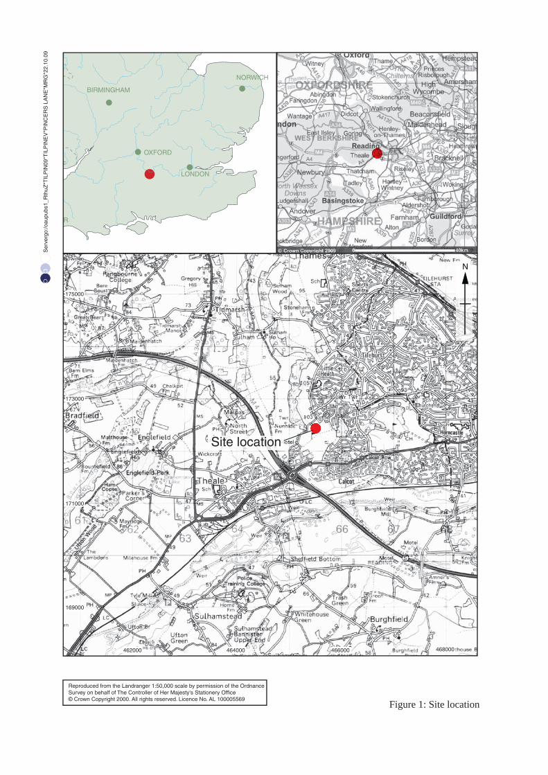
1.1 Location and scope of work1.1.1 In October 2009 OA carried out a field evaluation at Pincents Hill, Tilehurst, Reading
(Fig. 1) for CgMs Consulting on behalf of Blue Living Ltd in respect of a planning application (09/01432/OUTMAJ) submitted to West Berkshire Council. The work was carried out in accordance with a specification produced by CgMs Consulting (Bourn 2009) and agreed with Duncan Coe Archaeological Officer for West Berkshire Council. The development site is situated south of Pincents Lane and to the west of Magpie Way, at grid reference SU 465450, 172260.
1.2 Geology and topography1.2.1 The northern extent of the site lies on an area of high ground (c.100m OD) which then
slopes down to 53m OD to the south and southwest towards the M4. The geology of the site consists predominantly of the Lambeth Group (clay, silt and sand) while the north-western part is London Clay. A small area of drift geology known as Gerrards Cross Gravel Formation is present across the northern section of the site. Areas of modern disturbance and earthen bank remains are present close to Pincents Manor. Isolated earthen bank remains and a pond are situated within the site, relict features of a former golf course.
1.3 Archaeological background1.3.1 The archaeological background to the evaluation has been the subject of a separate desk
study (Heard and Pugh, 2008) the results of which are summarized below.
1.3.2 The Trust for Wessex Archaeology (TWA) undertook a limited evaluation of the site in 1987 (Trust for Wessex Archaeology 1987). This comprised the excavation of a number of test pits and a few longer trenches. The evaluation did not reveal any archaeological features but did recover a number of prehistoric flint artefacts and Roman pottery. The nature of the finds is possibly suggestive of settlement activity nearby.
1.3.3 Roman brick, tile and tessarae were said to have been found close to Pincent’s Farm in 1897 (VCH 1906, 215), as well as a coin of Domitian (MWB3661/UID241363), the location of the finds are also marked on the 1912-1975 Ordnance Survey Maps. These finds suggest the presence of a Roman building; the site has been included in Scott’s gazetteer of Roman villas (Scott 1993). Three sherds of Roman 'grey cooking pot' were found in the
© Oxford Archaeology Page 3 of 16 October 2009

Pincents Hill, Tilehurst, Reading. Evaluation Report v.2
1960s whilst digging on the site of the Roman building. The farmer stated that nothing was uncovered when the field was ploughed during the Second World War.
2 EVALUATION AIMS
2.1.1 To establish the presence/absence of archaeological remains within the proposal area and to determine the extent, condition, nature, character, quality and date of any archaeological remains present.
(i) To establish the ecofactual and environmental potential of archaeological deposits and features.
(ii) To clarify the results of the TWA 1987 evaluation.
(iii) To make available the results of the investigation.
3 EVALUATION METHODOLOGY
3.1 Scope of fieldwork3.1.1 The evaluation consisted of 29 trenches (Fig. 2). However, Trench 20 was not
excavated due to its close proximity to a badger sett. Trenches 1 and 2 were located in a horse paddock south of Pincents Lane. Trench 2 was divided into two parts (2a and 2b) following discussions with Duncan Coe, County Archaeologist, West Berkshire Council. The second part of Trench 2 was positioned to further clarify the alignment and character of linear features identified in Trench 1. Twenty-six trenches were located in the Kennet Valley each measuring 50m x 1.8m. A number of trenches were slightly repositioned to avoid badger setts, features associated with the golf course and paths.
3.2 Fieldwork methods and recording3.2.1 The overburden was removed under close archaeological supervision by a 360°
mechanical excavator fitted with a toothless bucket. A JCB excavator was used in the area of the horse paddock due to the access restrictions.
3.2.2 The trenches were cleaned by hand as required and features sampled to determine their extent and nature, and to retrieve finds. All trenches and deposits were recorded using proforma sheets. All archaeological features were planned and where excavated their sections drawn at scales of 1:20. Features were photographed using black and white print film and digital format. Recording followed procedures laid down in the OAU Fieldwork Manual (ed D Wilkinson, 1992).
3.3 Finds3.3.1 Finds were recovered by hand during the course of the excavation and bagged by
context.
3.4 Presentation of results3.4.1 A description of soil and ground conditions is given and the distribution of
archaeological deposits described. The results of the evaluation are summarised, and trenches are broadly described by area, with a more detailed description reserved for trenches containing noteworthy deposits. This is followed by a description of the finds and a discussion and interpretation of the results.
© Oxford Archaeology Page 4 of 16 October 2009

Pincents Hill, Tilehurst, Reading. Evaluation Report v.2
3.4.2 A table of contexts is given which details individual contexts and states the depth of the underlying natural horizon within each trench.
4 RESULTS: GENERAL
4.1 Soils and ground conditions4.1.1 The natural geology varied throughout the site. The eastern area of the site is
predominantly a mid brown clay and sandy silts of the Lambeth Group. London Clay was identified in the north western area. Gerrards Cross Gravel Formation was identified in the three trenches located in the horse paddock at the northernmost extent of the site. This field is generally flat with a slight slope to the south, and contained the remains of low narrow banks said to be the remains of WW II allotment boundaries.
4.1.2 The site is generally dry and well drained and the water table was not encountered in any of the evaluation trenches.
4.1.3 Significant landscaping deposits were identified in the southern and western areas of the site. These were up to 1.4m thick and generally consisted of silty sands and clay. The landscaping deposits identified to the south (Trenches 21-23) are likely to be a result of the landscaping of the recreation ground adjacent to the site (Trust for Wessex Archaeology 1987) . Further landscaping deposits were identified in the valley area associated with the formation of bunkers and greens for the former golf course.
4.2 Distribution of archaeology 4.2.1 Significant archaeological features were identified to the north of the site in Trenches 1
and 2b. A field boundary, probably dating to the post medieval period, was identified at the south east extremity of the site.
5 RESULTS: DESCRIPTIONS
5.1 Horse paddock (Trench 1)5.1.1 Trench 1 (Fig. 3) was aligned north-west south-east and located close to the eastern
boundary of the paddock. This trench revealed six linear features.
5.1.2 Starting from the north western end of the trench, the first ditch (102) was aligned east-west. It was 1.25m wide and filled with a loose dark grey sandy silt (103) with 20% sub angular flint pebbles. It appeared to cut the fill of ditch 104 to the south although this relationship was not clear. This feature was not excavated.
5.1.3 A ditch (104) aligned northeast-southwest was revealed directly to the south of ditch 102. This was 3m wide and filled with a loose mid/dark grey sandy silt (105) with 25% poorly sorted sub angular pebbles. This feature was partially excavated. A number of sherds of domestic wares were recovered dating to the Late Iron Age/Early Roman periods. The dimensions, character and alignment of this feature suggest that it is the same ditch as 205 identified in Trench 2b.
5.1.4 Two ditches (106 and 108) aligned east-west and north-south respectively were revealed. Neither ditch was excavated, but in plan ditch 108 appeared earlier than ditch 106. Both ditches were filled with a loose mid grey sandy silt, with the fill of 108 (109) having a slightly higher percentage of flint pebbles (20%). No finds were recovered from the fill of ditch 106 (107), but a number of sherds dating to the Late Iron Age/Early Roman period were recovered from the surface fill (109) of ditch 108.
© Oxford Archaeology Page 5 of 16 October 2009

Pincents Hill, Tilehurst, Reading. Evaluation Report v.2
5.1.5 Ditch 110 was located in the middle of the trench. This was 1.05m wide and aligned east-west. This feature was excavated to a depth of 0.3m for finds retrieval, producing a single sherd of abraded Samian ware, tentatively dated to the 2nd century.
5.1.6 The south-eastern most feature in this trench was ditch 112. This was 0.65m wide with straight well defined edges. This feature was not excavated and no finds were recovered from the surface.
5.2 Horse Paddock (Trenches 2a and 2b)5.2.1 Trench 2a was located at the south-western corner of the paddock and aligned
northeast-southwest. As no archaeological features were being revealed it was suggested by Duncan Coe (Archaeological Officer for West Berkshire Council) that excavation cease and continue in a new location to further investigate the alignment and nature of the features identified in Trench 1 and to establish if archaeological features crossed the recently installed path of the water pipeline running parallel to Trench 1.
5.2.2 Trench 2b (Fig. 4) was aligned northwest-southeast, parallel to and 35m west of Trench 1. Two linear features were revealed.
5.2.3 A ditch terminus (207) aligned northeast-southwest was revealed. This feature was 0.65m wide and filled with a loose dark grey sandy silt (208). This feature was not excavated as a quantity of pottery dating to the Late Iron Age/Early Roman period was recovered from its surface.
5.2.4 A 2.1m wide ditch (205) aligned northeast-southwest was also revealed. This was filled with a loose dark grey sandy silt (206). This feature was partially excavated but no finds were recovered. The dimensions, character and alignment of this feature suggest that it is likely to be a continuation of ditch 104, identified in Trench 1, which was dated to the Late Iron Age/Early Roman period.
5.2.5 A small, shallow, circular feature (210) was investigated. This was 0.4m in diameter and 0.06m deep and filled with a moderately compact mid grey brown sandy silt with frequent charcoal (211). The edges of this feature were ill defined and the fill was suggestive of burnt out roots.
5.3 North-eastern area (Trenches 3-10)5.3.1 Trenches 3 to 10 were all placed on the relatively steep slope forming the northern
slope of the Kennet Valley at the eastern end of the site. This area is characterised by rough ground and the remains of earthworks associated with the former golf course.
5.3.2 Apart from a modern landscaping deposit identified in Trench 4 all the trenches in this area revealed topsoil, averaging 0.35m in depth, directly overlaying the natural geology. The natural geology identified in the majority of the trenches (Trenches 4, 5, 6, 8 and 10 ) consisted of a compact mid-brown clay with occasional gravel bands. However, the northern end of Trenches 3 and 7 and the eastern end of Trench 9 were higher up the slope to the north and revealed natural gravels.
5.4 Western area (Trenches 15-19)5.4.1 Trenches 15 and 16 (Fig. 2) were located on the northern face of the dry valley. These
trenches revealed topsoil, averaging 0.32m thick, directly overlying natural sand. Trenches 17, 18 and 19 were placed across the base of the dry valley. A deposit up to 0.82m in depth was identified within the trenches. The deposit generally consisted of a
© Oxford Archaeology Page 6 of 16 October 2009

Pincents Hill, Tilehurst, Reading. Evaluation Report v.2
compact mid-brown silty sand, with occasional charcoal, CBM and modern debris. This deposit is probably associated with landscaping for the golf course. No archaeological features or deposits were identified.
5.5 Southern area (Trenches 21-24)5.5.1 These trenches were located at the southern end of the site on ground gently sloping
to the south. These trenches were typified by a landscaping deposit between 0.8m and 1.3m deep, which is probably associated with landscaping of the adjacent recreation ground to the southeast. No archaeological features were identified.
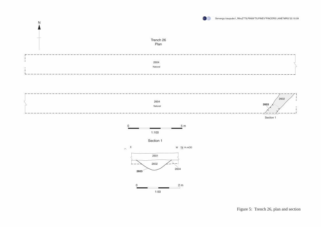
5.6 South-eastern area (Trenches 26 and 29)5.6.1 These trenches (Figs. 2, 5 and 6) were located at the south eastern corner of the site.
They revealed an average of 0.3m of topsoil directly onto natural clay. A ditch (2903 and 2603) was revealed at the eastern end of Trench 29 and continued through the middle of Trench 26. The dimensions of this ditch averaged 0.6m wide and 0.4m deep and it was generally filled with a compact brown clay silt (2904 and 2602).
5.7 South-eastern area (Trenches 25, 27, 28) 5.7.1 These Trenches were located on a relatively flat area in the southern part of the site.
They revealed a topsoil typically 0.3m deep onto a brown clay natural. No archaeological features were identified.
5.8 Central area (Trenches 11-14)5.8.1 This field is covered in well maintained grass and was not part of the former golf
course. A dry valley starts at the eastern side of this field and extends into the western area. Trenches 12 and 14 were placed through the base of the dry valley. Trenches 11 and 13 were placed on a slight ridge on the southern side of the valley.
5.8.2 Trench 12 revealed a linear feature (1204) at the base of the dry valley. This feature was 1.2m wide and 0.45m in depth and filled with a compact mid grey brown sandy silt (1205). This feature's position and alignment (NE-SW) corresponded to the base of the dry valley. Although this feature appeared ditch-like in plan, the diffused edges and character suggested it was formed by saturation of the ground at the base of the valley during wet periods. A single fragment of medieval tile was recovered from this feature. This feature was overlain by two distinct colluvial deposits (1202, 1203) totalling 0.84m in depth. The colluvial deposits generally consisted of moderately compact, mid brown silty sands, with the upper deposit (1202) being sightly darker.
5.8.3 Trench 14 was excavated to a maximum safe depth of 1.2m, but did not reach natural geology. Three colluvial deposits (1402, 1403, 1404) were identified. These generally consisted of moderately compact mid-brown silty sands, with the upper deposit having a significantly higher percentage of chalk inclusions. Small abraded fragments of ceramic building material were noted from each of the deposits but not retained.
5.8.4 Trenches 11 and 13 both revealed 0.36m of topsoil directly overlying natural geology, which consisted of yellow sandy gravels. No archaeological features or deposits were identified.
© Oxford Archaeology Page 7 of 16 October 2009

Pincents Hill, Tilehurst, Reading. Evaluation Report v.2
6 FINDS
6.1 General6.1.1 A total of 15 sherds of pottery weighing 261.3g were recovered. These are mostly of
Late Iron Age/ Early Roman date but include one sherd of Samian ware, possibly dating to the 2nd century. One undiagnostic flint flake was recovered. All the pottery was examined and spot-dated. As the quantity of pottery is so small it has not been presented in a separate table but is shown below.
6.2 Roman Pottery6.2.1 Context 105, 4 sherds (4 distinct vessels), 33.2g: 1 flint and grog tempered body sherd
from a jar. 2 grog tempered body sherds. 1 sand tempered body sherd. Late Iron Age-Early Roman date.
6.2.2 Context 109, 4 sherds, 19g: Four joining black burnished body sherds. Late Iron Age-Early Roman date.
6.2.3 Context 111, 1 sherd, 3.8g. Very abraded Samian sherd. Possibly 2nd century.
6.2.4 Context 208, 6 sherds from 5 distinct vessels, 205.3g: two course flint tempered body sherds. One sand tempered storage jar rim. 2 grog tempered body sherds. 1 sand tempered body sherd. Late Iron Age-Early Roman date.
6.3 Lithics6.3.1 Context 100, one undiagnostic flake.
6.4 Ceramic Building Material6.4.1 Context 1404, five fragments of medieval tile.
6.4.2 Context 1205, one fragment of medieval tile.
7 DISCUSSION AND INTERPRETATION
7.1 Reliability of field investigation7.1.1 The Trenches were positioned to give good overall coverage of the site area. Ground
conditions were good and the natural horizon clearly visible. Features were well defined and despite limited hand excavation undertaken, sufficient dating material was recovered to mean that the results of the evaluation are considered reliable.
7.2 Overall interpretation
Summary of results7.2.1 Despite a visual scan of the spoil heaps only one undiagnostic flint flake was recovered
from the topsoil. This is at odds with the number (14) found in the evaluation conducted by the Trust for Wessex Archaeology in 1987. The Trust for Wessex Archaeology evaluation was carried out prior to landscaping for the golf course which probably involved significant soil movements and possibly the importation of topsoil. This is likely to have had a significant effect on the distribution of finds.
7.2.2 The Roman features identified in the horse paddock on the gravel plateau present significant evidence of Roman activity. These features appear to be field or enclosure
© Oxford Archaeology Page 8 of 16 October 2009
Pincents Hill, Tilehurst, Reading. Evaluation Report v.2
boundaries. The finds recovered suggest settlement activity in the vicinity. This evidence may relate may relate to the evidence of a Roman building (UID241363) found close to Pincents Farm 400m to the west.
7.2.3 The ditch identified in Trenches 26 and 29 closely relates to a field boundary visible on the Tilehurst Enclosure maps, 1817 and 1843. It is no longer visible on the Ordnance Survey map of 1878-79.
7.2.4 It is evident that significant areas of the site have been affected by landscaping. The archaeological horizon has been truncated by works relating to the creation of the recreation ground to the south as identified in the Trust for Trust for Wessex Archaeology evaluation carried out in 1987. Extensive landscaping was carried out (post 1987) in the form of bunkers, greens and ponds during the formation of the now disused golf course which occupied a large part of the present evaluation area.
© Oxford Archaeology Page 9 of 16 October 2009
Pincents Hill, Tilehurst, Reading. Evaluation Report v.2
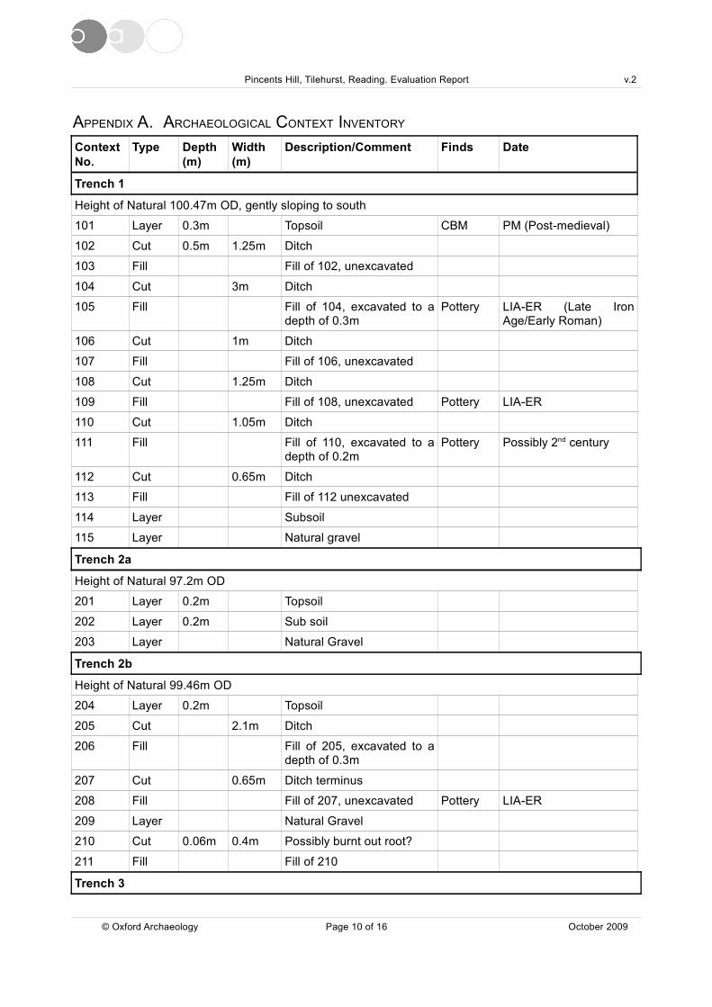
APPENDIX A. ARCHAEOLOGICAL CONTEXT INVENTORY
Context No.
Type Depth (m)
Width (m)
Description/Comment Finds Date
Trench 1
Height of Natural 100.47m OD, gently sloping to south
101 Layer 0.3m Topsoil CBM PM (Post-medieval)
102 Cut 0.5m 1.25m Ditch
103 Fill Fill of 102, unexcavated
104 Cut 3m Ditch
105 Fill Fill of 104, excavated to a depth of 0.3m
Pottery LIA-ER (Late Iron Age/Early Roman)
106 Cut 1m Ditch
107 Fill Fill of 106, unexcavated
108 Cut 1.25m Ditch
109 Fill Fill of 108, unexcavated Pottery LIA-ER
110 Cut 1.05m Ditch
111 Fill Fill of 110, excavated to a depth of 0.2m
Pottery Possibly 2nd century
112 Cut 0.65m Ditch
113 Fill Fill of 112 unexcavated
114 Layer Subsoil
115 Layer Natural gravel
Trench 2a
Height of Natural 97.2m OD
201 Layer 0.2m Topsoil
202 Layer 0.2m Sub soil
203 Layer Natural Gravel
Trench 2b
Height of Natural 99.46m OD
204 Layer 0.2m Topsoil
205 Cut 2.1m Ditch
206 Fill Fill of 205, excavated to a depth of 0.3m
207 Cut 0.65m Ditch terminus
208 Fill Fill of 207, unexcavated Pottery LIA-ER
209 Layer Natural Gravel
210 Cut 0.06m 0.4m Possibly burnt out root?
211 Fill Fill of 210
Trench 3
© Oxford Archaeology Page 10 of 16 October 2009

Pincents Hill, Tilehurst, Reading. Evaluation Report v.2
Context No.
Type Depth (m)
Width (m)
Description/Comment Finds Date
Height of Natural 93.06m OD at north end. 87.45m OD at south end. Trench slopes steeply down to south.
301 Layer 0.25m Topsoil
302 Layer Natural
Trench 4
Height of Natural 90.88m OD at N end.86.18m OD at south end, Trench slopes steeply to south.
401 Layer 0.25m Topsoil
401 Layer 1m 8m Landscaping deposit Mod
403 Layer Natural
Trench 5
Height of Natural 89.58m OD at north end. 82.98m OD at south end, Trench slopes steeply to south.
501 Layer 0.3m Topsoil
502 Layer Natural
Trench 6
Height of Natural 85.12m OD at NW end. 81.95m OD at SE end, Trench slopes gently to south.
601 Layer 0.3m Topsoil
601 Layer Natural
Trench 7
Height of Natural 91.90m OD at north end. 82.9m OD at south end, Trench slopes steeply to south.
701 Layer 0.34m Topsoil
702 Layer Natural
Trench 8
Height of Natural 85.91m OD at NE end. 79.9m OD at SW end, Trench slopes steeply to SW.
801 Layer 0.32 Topsoil
802 Layer Natural
Trench 9
Height of Natural 88.54m OD at west end. 86.6m OD at east end, Trench slopes gently to east.
901 Layer 0.34 Topsoil
902 Layer Landscaping deposit Mod
903 Layer Natural
Trench 10
Height of Natural 82.80m OD at north end. 75.51m OD at south end, Trench slopes steeply to south.
1001 Layer 0.35m Topsoil Flint Pre-Hist
1002 Layer 0.2m Landscaping deposit Mod
1003 Layer Natural
Trench 11
© Oxford Archaeology Page 11 of 16 October 2009

Pincents Hill, Tilehurst, Reading. Evaluation Report v.2
Context No.
Type Depth (m)
Width (m)
Description/Comment Finds Date
Height of Natural 74.05m OD. Trench located on level ground.
1101 Layer 0.34m Topsoil
1102 Layer Natural
Trench 12
Height of Natural 73.47m OD at west end. 77.32m OD at east end, Trench placed across base of dry valley.
1201 Layer 0.32m Topsoil
1202 Layer 0.56m Max
Colluvium CBM medieval
1203 Layer 0.28m Colluvium
1204 Cut 0.4m 0.8m Naturally formed feature
1205 Fill 0.4m 0.8m Natural, discoloured by water at base of dry valley
CBM medieval
Trench 13
Height of Natural 74.06m OD. Trench placed across base of dry valley.
1301 Layer 0.4m Topsoil
1302 Layer Natural
Trench 14
Height of Natural 72.06m OD at lowest point in dry valley
1401 Layer 0.36m Topsoil
1402 Layer 0.18m Colluvium
1403 Layer 0.5m Colluvium
1404 Layer Colluvium, base not reached
CBM medieval
Trench 15
Height of Natural 75.09m OD at NE end. 71.3m OD at SW end, Trench slopes to south-west
1501 Layer 0.3m Topsoil
1502 Layer Natural
Trench 16
Height of Natural 70.19m OD at NE end. 67.0m OD at SW end, Trench slopes gently to south.
1601 Layer 0.34m Topsoil
1602 Layer Natural
Trench 17
Height of Natural 71.92m OD at south end. 68.86m OD at north end, Trench slopes steeply to north.
1701 Layer 0.34m Topsoil
1702 Layer 0.38m Colluvium
1703 Layer 0.6m Colluvium
1704 Layer Natural
© Oxford Archaeology Page 12 of 16 October 2009
Pincents Hill, Tilehurst, Reading. Evaluation Report v.2
Context No.
Type Depth (m)
Width (m)
Description/Comment Finds Date
Trench 18
Height of Natural 63.35m OD
1801 Layer 0.36m Topsoil
1802 Layer 0.8m Landscaping deposit Mod
1803 Layer Natural
Trench 19
Height of Natural 61.74m OD at north end. 59.58m OD at south end, Trench slopes gently to south.
1901 Layer 0.3m Topsoil
1902 Layer 0.82m Landscaping deposit Mod
1903 Layer Natural
Trench 21
Height of Natural 62.81m OD at west end. 61.84m OD at east end.
2101 Layer 0.28m Topsoil
2102 Layer 0.8m Landscaping deposit Mod
2103 Layer Natural
Trench 22
Height of Natural 64.1m OD at eastern end. 63.12m OD at west end.
2201 Layer 0.3m Topsoil
2202 Layer 1.3m Landscaping deposit Mod
2203 Layer Natural
Trench 23
Height of Natural 65.64m OD at north end. 62,05m OD at east end.
2301 Layer 0.36m Topsoil
2302 Layer 1.4m Landscaping deposit Mod
2303
Trench 24
Height of Natural 70.98m OD at NE end. 69.6mOD at SW end.
2401 Layer 0.3m Topsoil
2402 Layer 0.82m Landscaping deposit Mod
2403 Layer Natural
Trench 25
Height of Natural 76.7m OD at north end. 73.1m OD at west end.
2501 Layer 0.2m Topsoil
2502 Layer 0.5m Landscaping deposit Mod
2503 Layer Natural
Trench 26
© Oxford Archaeology Page 13 of 16 October 2009
Pincents Hill, Tilehurst, Reading. Evaluation Report v.2
Context No.
Type Depth (m)
Width (m)
Description/Comment Finds Date
Height of Natural 74.17m OD at east end. 77.84mOD at east end, Trench slopes steeply to west.
2601 Layer 0.32m Topsoil
2602 Fill 0.4m Fill of 2603
2603 Cut 0.5m 0.8m Ditch No
2604 Layer Natural
Trench 27
Height of Natural 77.69m OD at NE end. 75.45m OD at SW end.
2701 Layer 0.3m Topsoil
2702 Layer Natural
Trench 28
Height of Natural 79.1m OD at SW end. 79.47m OD at NE end.
2801 Layer 0.3m Topsoil
2802 Natural
Trench 29
Height of Natural 79.08m OD at north end. 77.88m OD at south end.
2901 Layer 0.32m Topsoil
2902 Layer Natural
2903 Cut 0.32m 0.6m Ditch
2904 Fill 0.32m Fill of 2903 No
© Oxford Archaeology Page 14 of 16 October 2009

Pincents Hill, Tilehurst, Reading. Evaluation Report v.2
APPENDIX B. BIBLIOGRAPHY AND REFERENCES
Bourn R 2009, Specification for an Archaeological Evaluation. Pincents Hill Tilehurst Reading, unpublished CgMs document.
Ditchfield P H and Page W (Eds) 1906, A History of the County of Berkshire. Victoria County History. Vol 1: p215
Heard H, Pugh G 2008, Archaeological Desk Based Assessment, Tilehurst West Berkshire, unpublished CgMs document.
OA 1992, Fieldwork Manual (ed. D Wilkinson, first edition, August 1992)
Scott E 1993, A gazetteer of Roman Villa in Britain. Leicester archaeology monographs, Vol 1: p24
Trust for Wessex Archaeology 1987, Archaeological evaluation at Turnhams Farm. Unpublished client report.
© Oxford Archaeology Page 15 of 16 October 2009

Pincents Hill, Tilehurst, Reading. Evaluation Report v.2
APPENDIX C. SUMMARY OF SITE DETAILS
Site name: Pincents Lane, Tilehurst
Site code: TILPIN 09
Grid reference: SU 465450, 172260.
Type of evaluation: Trenching
Date and duration: 2nd-15th October 2009
Area of site: 21 hectares
Summary of results: A number of Roman linear features and a Post-medieval field boundary were discovered.
Location of archive: The archive is currently held at OA, Janus House, Osney Mead, Oxford, OX2 0ES, and will be deposited with West Berkshire Museum in due course, under the following accession number: NEBYM:2009.38
© Oxford Archaeology Page 16 of 16 October 2009
495000
208000 209000 210000 211000
Reproduced from the Landranger 1:50,000 scale by permission of the Ordnance Survey on behalf of The Controller of Her Majesty's Stationery Office© Crown Copyright 2000. All rights reserved. Licence No. AL 100005569
Figure 1: Site location
Ser
verg
o:/o
aupu
bs1_
Rth
uZ*T
ILP
IN09
*TIL
PIN
EV
*PIN
CE
RS
LA
NE
*MR
G*2
2.10
.09
F
LONDON
OXFORD
NORWICH
BIRMINGHAM
R
173000
175000
171000
169000
468000464000462000 466000
N
Site location


104102 106 108
112
105103
107109
111
110113
Land Drain
Servergo:/oaupubs1_RthuZ*TILPIN09*TILPINEV*PINCERS LANE*MRG*22.10.09
Figure 3: Trench 1, plan and sections
Section 1
Section 2
Trench 1Plan
Section 1 Section 2
11104
105
101
SE NWNW SE
111
10
99.41 mOD99.36 mOD
115Natural
115Natural
114114
1:100
0 5 m
1:50
0 2 m
N

206 205
Section 1
Section 2
209Natural
208
207
Disturbance(Possible tree root activity)
202
205
204
206
SE NW
Trench 2bSection 1
210211
SW NE
Trench 2bSection 2
Trench 2b Plan
Servergo:/oaupubs1_RthuZ*TILPIN09*TILPINEV*PINCERS LANE*MRG*22.10.09
Figure 4: Trench 2b, plan and sections
209Natural
209Natural
209Natural
209Natural
209
211 210
1:100
0 5 m
1:50
0 2 m
N
Section 1
2602
2603
2604
Natural
Trench 26Plan
2604
Natural
Servergo:/oaupubs1_RthuZ*TILPIN09*TILPINEV*PINCERS LANE*MRG*22.10.09
Figure 5: Trench 26, plan and section
2601
2602
26032604
E W
Section 1
78.14 mOD
N
1:100
0 5 m
1:50
0 2 m

2903
Section 1
2902
Natural
2902
Natural
Trench 29Plan
2904
S N
2903
2904
2901
2902
Section 1
Figure 6: Trench 29, plan and section
Servergo:/oaupubs1_RthuZ*TILPIN09*TILPINEV*PINCERS LANE*MRG*22.10.09
79.41 mOD
N
1:100
0 5 m
1:50
0 2 m


Di rec to r : Dav i d Jen n i n gs , B A M IFA F SA
Oxf o rd A rch aeo l o g i ca l U n i t i s aP r i v a te L i m i ted C o m pan y , N o: 1 6 1 8 5 9 7and a Reg i s te red Char i t y , N o: 2 8 5 6 2 7
OA Nor thMi l l 3Moor LaneLancas te r LA1 1GF
t : +44 ( 0 ) 1524 541 000f : +44 ( 0 ) 1524 848 606e : oanor th@thehuman jou r ney .ne tw :h t tp : / / thehuman jou r ney .ne t
Head Of f ice/Reg i s te red O f f iceJanus HouseOsney MeadOxfo rd OX2 0ES
t : +44 ( 0 ) 1865 263 800f : +44 ( 0 )1865 793 496e : i n fo@thehuman jou r ney .ne tw : h t t p : / / t h e h u m a n j o u r n e y . n e t
OA Eas t15 T r a fa lga r WayBar H i l lCambr idgesh i reCB23 8SQ
t : +44 (0 )1223 850500f : +44 (0 )1223 850599e : oaeas t@thehuman jou r n ey .ne tw :h t tp : / / thehuman jou r ney .ne t /oaea s t
OA Méd i te r ranée115 Rue Mer lo tZAC La Louvade34 130 Maugu ioF rance
t : +33 ( 0 ) 4 . 67 .57 .86 .92f : +33 ( 0 ) 4 . 67 .42 .65 .93e : oamed@oamed. f rw : h t tp : / /oamed. f r /