Petroleum Potential Evaluation of Anambra Basin
12
CHAPTER ONE 1.0 INTRODUCTION The Anambra Basin is one of the major sedimentary basins of Nigeria. It comprises of a nearly triangular shaped embayment covering about 30,00sqKm and having a total sedimentary thickness of about 9km. The stratigraphic history of the basin is characterized by the second sedimentary phase (Campanian – Eocene) in south-eastern depositional cycle (Short and Stӓuble, 1967; Murat, 1972; Obi et al., 2001). This sedimentary phase was initiated by the Santonian folding and uplift of the Abakaliki anticlinorium along the NE-SW axis, (fig. 1.1) and the consequent dislocation of the depocenter into the Anambra Basin on the northwest and the Afikpo syncline on the southeast (Short and Stӓuble, 1967; Murat, 1972). The resulting succession comprises the Nkporo group, Mamu formation, Ajali sandstone, Nsukka formation, Imo formation and Ameki group (fig 1.2). Early hydrocarbon exploration of the Anambra Basin is owed to the abundant Maastrichtian coal deposits. Several efforts to explore its petroleum potentials were unrewarding, resulting to neglect from both research groups and oil companies. Nevertheless, with the 1
-
Upload
chris-nwabu-okpalaeke -
Category
Documents
-
view
935 -
download
12
Transcript of Petroleum Potential Evaluation of Anambra Basin

CHAPTER ONE
1.0 INTRODUCTION
The Anambra Basin is one of the major sedimentary basins of Nigeria. It comprises
of a nearly triangular shaped embayment covering about 30,00sqKm and having a
total sedimentary thickness of about 9km. The stratigraphic history of the basin is
characterized by the second sedimentary phase (Campanian – Eocene) in south-
eastern depositional cycle (Short and Stӓuble, 1967; Murat, 1972; Obi et al., 2001).
This sedimentary phase was initiated by the Santonian folding and uplift of the
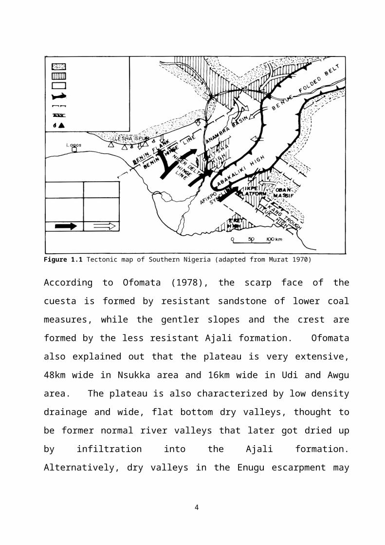
Abakaliki anticlinorium along the NE-SW axis, (fig. 1.1) and the consequent
dislocation of the depocenter into the Anambra Basin on the northwest and the
Afikpo syncline on the southeast (Short and Stӓuble, 1967; Murat, 1972). The
resulting succession comprises the Nkporo group, Mamu formation, Ajali
sandstone, Nsukka formation, Imo formation and Ameki group (fig 1.2).
Early hydrocarbon exploration of the Anambra Basin is owed to the abundant
Maastrichtian coal deposits. Several efforts to explore its petroleum potentials
were unrewarding, resulting to neglect from both research groups and oil
companies. Nevertheless, with the increasing quest for petroleum development of
Nigeria inland basins, the advent of improved exploration techniques, integrated
basin analytical methods, and ultimately the global energy demand, petroleum
exploration and prospecting activities within the Anambra Basin has taken a new
dimension. This research provides required information towards optimization of
petroleum exploration and exploitation of the Anambra Basin.
1

1.1 LOCATION AND ACCESSIBILITY
The Anambra Basin is located in the southern part of the regionally extensive
northeast-southwest trending Benue Trough (fig. 1.3). It lies within longitude
7000’E to 8000’E and latitude 6000’N to 7000’N. On the west, it is bounded by the
Precambrian basement complex rocks of western Nigeria and on the east by the
Abakaliki anticlinorium. The boundaries to the north and south are not very well-
defined (Uma and Onuoha, 1997).
Good road networks traverse virtually all the outcrops within the Anambra basin.
The Enugu – Onitsha expressway cuts through the outcrops of Campanian,
Maastrichtian and Eocene deposits at Iva valley, Agu-Abor and Umunya
respectively, enabling detailed descriptive study of the outcrops. Also along the
Okigwe – Umuahia districts, Campanian and Maastrichtian deposits are accessed
by road cuts.
1.2 RELIEF AND DRAINAGE
Anambra Basin is characterized generally by hilly and undulating relief. The major
landforms include the highlands of Awgu, Udi, Nsukka, Ngwo, Umunya, Obosi and
Nsugbe. All the formations generally trend north to south, and various prominent
landforms and related features have been carved out of them (Ofomata, 1975).
The Nsukka – Okigwe cuesta is one of the prominent landforms which, in Enugu
area, is made up of two distinctive features of Enugu and Awgu escarpments, and
the Udi – Nsukka plateau (Ofomata, 1975).
2
Figure 1.1 Tectonic map of Southern Nigeria (adapted from Murat 1970)
According to Ofomata (1978), the scarp face of the cuesta is formed by resistant
sandstone of lower coal measures, while the gentler slopes and the crest are
formed by the less resistant Ajali formation. Ofomata also explained out that the
plateau is very extensive, 48km wide in Nsukka area and 16km wide in Udi and
Awgu area. The plateau is also characterized by low density drainage and wide,
flat bottom dry valleys, thought to be former normal river valleys that later got
dried up by infiltration into the Ajali formation. Alternatively, dry valleys in the
Enugu escarpment may be caused by progressive migration of the water table
caused by gullying and ravination (Ofomata, 1978).
The present Anambra state falls into two main landform regions: a high region of
moderate elevation, which covers much of the state south of the Anambra river,
and low plains to the west, north and east of the highlands. The highland region is
3
highest in the south-east (about 410m above sea level) and gradually decreases in
height (about 33m) in the north-west on the banks of the Anambra river and the
Niger (AAPG Bulletin, 2004).
At Onitsha and Otuocha, the cuesta provides well drained low land, very close to
the river, thereby enabling settlements to extend to the banks of the river (AAPG
Bulletin, 2004).
The drainage pattern of Anambra Basin is dendritic. It is drained mainly by the
Anambra river and its main tributaries, the Mamu and Adada river. The Anambra
river rises on the Gala plateau near Ankpa in Kogi state and flows through the
northern low plain where it meanders heavily, developing oxbow lakes and
abandoned meander channels. Its largest left bank tributary is the Mamu river,
which drains extensive areas of Uzo-Uwani in the northwest and Awgu in
southwest (fig. 1.4). The higher cuesta seperates the numerous east-flowing
tributaries of the Mamu river from the west flowing rivers (the Idemili, the Nkisi
etc.) which drains the dip slope of the cuesta.
1.3 CLIMATE AND VEGETATION
Anambra Basin lies within the equatorial monsoonal climatic belts of Nigeria
typified by rainy and dry seasons. Its climate is hot and humid, with maximum
temperature of 340C and minimum of 180C – 210C towards the end of the rains.
The rainy season lasts for a period of about eight months (March to October) with 4

mean annual rainfall of 152.4cm to 203.2cm in the Enugu area to 101.6cm to
228.6cm in Idah area (Offodile, ). Dry season is relatively short and lasts for a
period of about four months (November to February).
Fig. 1.3 Location of the Anambra Basin (Adapted from Onyekuru and Iwuagwu, 2010).
The natural vegetation varies from tropical dry forest in the north, comprising of
tall trees with thick undergrowth and numerous climbers, to tropical rainforest in
the southern part, comprising of large overgrowth with shrubs, stunted trees and
tall elephant grasses.
1.4 REVIEW OF PREVIOUS WORKS
The deposition of organic sediments in Benue Trough under paleoanoxia was first
reported by Murat (1972) and was later examined in greater details by Petters
5
(1982), Petters and Ekweozor (1982), Ehinola (1995) and Akaegbobi and Schmitt
(1998).
Several workers including Simpson (1954) and Reyment (1965) described the
Nkporo shale group as dark grey, very fissile shale and mudstone with occasional
thin sandyshale interbeds, fine-grained sandstone and marl with coatings of
sulphur and numerous white specks of Bolivinia explicate. Murat (1972) also
agreed with this description of Nkporo shale group.
Petters and Ekweozor (1982) suggested that the dark grey Nkporo shale was
deposited in anoxia condition resulting from bottom water stagnation due to
density stratification caused by high input of terrrigenous organic matter and poor
circulation. While evaluating the geochemical characters of the Nkporo shale,
Tebo (2000) also reported that the shale were probably deposited under a strong
anoxic water condition.
According to Agagu and Ekweozor (1982), there is a presence of abundant organic-
rich shales as source rocks with organic carbon ranging from 0.22 to 4.16% within
the Anambra Basin. On investigation of source rock potential of various
formations in the Benue Trough and Anambra Basin, Obaje et. al. (1999) proposed
that the Nkporo/Enugu shale is the source rock for the petroleum system in the
Anambra Basin, having TOC values ranging from 1.1 – 4.2wt% and vitrinite
reflectance values ranging from 0.44 – 0.60R0%. When given sufficient maturity,
they also reported that the Mamu formation is capable of expelling hydrocarbon.
6

Ekweozor and Gormly (1983) described the Nkporo shale as an example of a
marine source rock composing of type II/III kerogens with low but consistent
contribution from marine organic matter.
The Campanian Nkporo shale was observed by Akaegbobi and Schmitt (1998) to be
a good example of mixed terrestrially marine source rock within the Anambra
Basin. Unomah and Ekweozor (1993) proposed that the shale in the Anambra
Basin and Afikpo syncline contain mainly terrestrially derived organic matter and
essentially gas prone. They also stated that the outcrop and near surface sections
of Nkporo shale are immature while the lower section is overcooked. Ojo, Ajibola
and Akande (2009) also concluded that the terrestrially derived type III organic
matter with potentials of generating gas is prevalent in the Campanian –
Maastrichtian formation. This is indicated by low hydrogen index (HI) values and
predominance of vitrinite. They further reported that the Total Organic Carbon
(TOC) values for the source rock interval of Campanian – Maastrichtian Enugu
formation vary from 1.29 to 4.42wt% and Soluble Organic Matter (SOM) content
ranges from 578 to 1931ppm, suggesting fair to good source rocks.
According to Unomah and Ekweozor (1993), the organofacies of Nkporo shale are
provincial with the Calabar flank having highest oil potential whereas those in the
Anambra Basin and Afikpo syncline are gas prone. After carrying out a
comprehensive study on the geology and petroleum potential of the Senonian to
Maastrichtian sediments in the Anambra Basin, Agagu (1978) recorded that the
sediments are organically rich but immature. Unomah and Ekweozor (1993),
Akaegbobi and Schmitt (1998), Obaje et. al. (1999) and Ajayi (2006), after a specific
study on the organic richness, quality and thermal maturity of the Mamu
formation and Nkporo shales, also reported that the sediments are organic-rich
7
but of immature status. Agagu and Ekweozor (1982) worked on the source rock
characteristics of the Senonian shales in the Anambra syncline and concluded that
the shale have good organic matter richness with maturity increasing significantly
with depth.
The Maastrichtian – Paleocene sediments in the southern and mainly in the
southwestern sector of the Anambra Basin, according to Ekine and Onuoha (2010),
should be the major sedimentary strata with liquid hydrocarbon potentials,
whereas the lower Cretaceous and particularly the Santonian sediments exhibit
the highest potentials for gaseous hydrocarbons. Akaegbobi and Udofia (2009)
suggested that hydrocarbons are probably being generated in the Anambra Basin
which may not have been expelled in large quantities. Onyekuru and Iwuagwu
(2010) suspected the profuse seepage of fluids from the lowermost section of
Nkporo shale at the outcrop along Leru section to be hydrocarbon.
Ekine and Onuoha (2010) attributed the absence of accumulated liquid
hydrocarbon in the north-central parts of the Anambra Basin to be lack of
adequate stratigraphic and structural traps relative to time of hydrocarbon
maturation. Onyekuru and Iwuagwu (2010) identified the alternation of
Highstand System Tract (HST) and Trangressive System Tracts (TST) sands and
shales respectively in an outcrop of Nkporo shales and Mamu formation along Leru
– Okigwe axis of the Anambra Basin. This alternation provides a union of reservoir
and seal rocks which are essential for hydrocarbon accumulation and stratigraphic
trapping.
Schmitt (1998), on evaluation of the economic potentials of the Mamu formation
and Nkporo/Enugu geological units reported that the Nkporo/Enugu shales
8
presented better evidence of organic matter preservation and petroleum
potential. He also identified only one petroleum system (upper Cretaceous –
lower Paleocene petroleum system) which consists of types II and III/II gas/oil
prone kerogens.
9