PETRA files/pdfs/documents/publications... · PETRA ® “As a geologist and PETRA product manager,...
48
Transcript of PETRA files/pdfs/documents/publications... · PETRA ® “As a geologist and PETRA product manager,...


PETRA®
“As a geologist andPETRA product manager,it’s my job to understand your challenges and make sure PETRA helps you meet them. Connecting directly to IHS data is one of those ways.It’s fast and simple, so you spend more time analyzing data, not loading it.”
Dana CoddingSubsurface Product Manager
PETRA provides multi-discipline reservoir management teams with the analysis tools needed for today’s exploration,exploitation and acquisition challenges.
Download your free PETRA trialat ihs.com/petraconnect
©2008 IHS Inc. All rights reserved.

RESERVOIR ISSUE 4 • APRIL 2008 3
APRIL 2008 – VOLUME 35, ISSUE 4
ARTICLESVolunteer Profi le: Talking with Travis Hobbs ........................................................... 20 by Heather Tyminski
Reservoir Engineering for Geologists Part 6 – Well Test Interpretation ................. 22 by Louis Mattar, and Lisa Dean
The Neoproterozoic Old Fort Point Formation, Southern Canadian Cordillera, Part 2................................................................. 29 by Mark D. Smith, R.W.C. (Bill) Arnott, and G.M. Ross
2008 CSPG CSEG CWLS Convention Special Events ........................................... 35
Time to start thinking about the 2008 CSPG Long-Time Members’ Reception ..... 38 by Regan Palsgrove
25th Anniversary Tournament Makes a Big Racket! .............................................. 40 by David Caldwell
2007 CSPG Tracks Awards ....................................................................................... 42
2007 CSPG Link Award ............................................................................................. 43
2007 CSPG Volunteer and Service Awards ............................................................ 45
CSPG Regional Graduate/Undergraduate Scholarships ........................................ 45 by David Middleton
DEPARTMENTSExecutive Comment ..................................................................................................... 5Corporate Relations ..................................................................................................... 7Technical Luncheons ..................................................................................................... 8Division Talks .............................................................................................................. 14Rock Shop ................................................................................................................... 27Advertisers Index ....................................................................................................... 46
FRONT COVERKufra Basin, Libya. Nubian Sandstone outcrop. Photo by Gary Johannson.
CSPG OFFICE#600, 640 - 8th Avenue SWCalgary, Alberta, Canada T2P 1G7Tel: 403-264-5610 Fax: 403-264-5898Web: www.cspg.orgOffi ce hours: Monday to Friday, 8:30am to 4:00pm
Business Manager: Tim Howard Email: [email protected] Services: Sarah Barton Email: [email protected] Communications & Public Affairs: Heather Tyminski Email: [email protected] & Conferences: Shauna Carson Email: [email protected] & Conferences Assistant: Tanya Santry Email: [email protected] Relations Manager: Sarah Barton Email: [email protected] & Services Manager: Lori Humphrey Clements Email: [email protected]: Dayna Rhoads Email: [email protected]
EDITORS/AUTHORSPlease submit RESERVOIR articles to the CSPG offi ce. Submission deadline is the 23rd day of the month, two months prior to issue date. (e.g., January 23 for the March issue).
To publish an article, the CSPG requires digital copies of the document. Text should be in Microsoft Word format and illustrations should be in TIFF format at 300 dpi., at fi nal size. For additional information on manuscript preparation, refer to the Guidelines for Authors published in the CSPG Bulletin or contact the editor.
Technical EditorsBen McKenzie Colin Yeo (Assistant Tech. Editor)Tarheel Exploration Encana CorporationTel: 403-277-4496 Tel: 403-645-7724Email: [email protected] Email: [email protected]
Coordinating EditorHeather TyminskiComunications and Public Affairs, CSPGTel: 403-513-1227, Email: [email protected]
ADVERTISINGAdvertising inquiries should be directed to Sarah Barton, Tel: 264-5610, Email: [email protected]. The deadline to reserve advertising space is the 23rd day of the month, two months prior to issue date.
The RESERVOIR is published 11 times per year by the Canadian Society of Petroleum Geologists. This includes a combined issue for the months of July/August.
Advertisements, as well as inserts, mailed with the publication are paid advertisements. No endorsement or sponsorship by the Canadian Society of Petroleum Geologists is implied.
The contents of this publication may not be reproduced either in part or in full without the consent of the publisher.
Design & Layout by Sundog Printing. Printed in Canada by Sundog Printing.
Additional copies of the RESERVOIR are available at the CSPG offi ce for $3.00.

RESERVOIR ISSUE 4 • APRIL 2008 5
CSPG EXECUTIVE
PRESIDENTLisa Griffi th • Griffi th Geoconsulting Inc.lgriffi th@griffi thgeoconsulting.com Tel: (403) 669-7494
VICE PRESIDENTGraeme Bloy • West Energy [email protected] Tel: (403) 716-3468
PAST PRESIDENT Colin Yeo • EnCana [email protected] Tel: (403) 645-7724
FINANCE DIRECTORJames Donnelly • ConocoPhillips [email protected] Tel: (403) 260-8000
ASSISTANT FINANCE DIRECTORDavid Garner • Chevron Canada [email protected] Tel: (403) 234-5875
PROGRAM DIRECTORRandy Rice • Suncor Energy [email protected] Tel: (403) 205-6723
SERVICE DIRECTORJen Vezina • Devon Canada [email protected] Tel: (403) 232-5079
ASSISTANT SERVICE DIRECTORAyaz Gulamhussein • NuVista Energy [email protected] Tel: (403) 538-8510
OUTREACH DIRECTORGreg Lynch • Shell Canada [email protected] Tel: (403) 691-2052
ASSISTANT OUTREACH DIRECTORMike DesRoches • DesRoches Consulting [email protected] Tel: (403) 828-0210
COMMUNICATIONS DIRECTORPeggy Hodgkins • [email protected] Tel: (403) 266-3225
CORPORATE RELATIONS DIRECTORMonty Ravlich • Sanjel [email protected]
On Being National
EXECUTIVE COMMENTA Message from the Programs Director, Randy Rice
The Canadian Society of Petroleum Geologists (CSPG) has aspired to be “national” for a considerable period of time but, from my perspective, it is falling significantly short of that mark, albeit not from a lack of trying. But more must be done.
This comment is a personal opinion of what it means, and takes, to be a national organization, what the CSPG is currently doing in its attempt to be national and, most importantly, what else it could do to advance into that ethereal realm of national relevance.
Indeed, “relevance” is the key word in any discussion of the CSPG being truly national. Any organization seeking national acknowledgement must serve its members, and prospective members, country-wide such that it promotes, and contributes to maintaining and advancing, their careers. It must do this for both professional, licensed, petroleum geologists and students seeking this accreditation. This is a no-brainer in downtown “Cowtown” since Calgary is the center of the Canadian energy industry, just as Toronto and Vancouver are minerals centers.
The challenge is to engender a sense of relevance with petroleum geologists, and students aspiring to be such, outside of the realm of the Western Canada Sedimentary Basin (WCSB). As the demand for fossil fuel energy increases worldwide, other basins in Canada are receiving more attention respecting their hydrocarbon potential, i.e., the Sverdrup Basin, interior and offshore basins on both western and eastern coasts, and some central Canadian basins. How do we connect, and stay connected, with the professional and student petroleum geologists in these regions?
Impediments to the CSPG attaining national
acknowledgement differ depending on whether prospective members are practicing professionals or students.
As a student, especially undergraduate, much professional awareness can come from what your educators expose you to. Unfortunately, there is still the mentality of two solitudes in many of our Geoscience/Geological Sciences/Earth Science/etc. departments across Canada. In traditional “hard rock” mining regions, those teaching sedimentary geology can be distinctly more inclined to talk about sediment-hosted ore deposits than hydrocarbon reservoirs (and of course the inverse is true in “soft rock” regions).
Much of the breadth of exposure passed on to students is a reflection of what an educator has done themselves during their careers and, as many university educators are necessarily specialists, tunnel vision can result in senior undergraduates. Students of sedimentary geology in some departments in Canada are not even aware the CSPG exists. We need to reach these students.
As a professional petroleum geologist in St. Johns, Halifax, Yellowknife, or Vancouver, the CSPG has got to offer you something if it wants you involved. It needs to provide information that helps you keep current, that allows you to increase your qualifications if desired, that makes you aware of career opportunities, that promotes collegial gatherings of peers and that seeks to represent your profession responsibly to the public so that a better understanding of the industry results. This is especially crucial as the public’s sensitivity to environmental concerns increases. Professional information provision and networking are clearly equally crucial, if not more so, to students; however, the type of information and networking styles needed differ.
(Continued on page 46...)

2007 Gold Sponsors
2007 Silver Sponsors
2007 Bronze Sponsors
2007 Platinum Sponsors
48th ANNUAL CSPG CLASSICElbow Springs Golf Club • June 18-20, 2008
CS
PG
CL A S S I C
The Golf Committee would like to thank the following sponsors:Registration Form
NAME:
SPOUSE’S NAME:
COMPANY:
ADDRESS (Bus.):
POSTAL CODE:
TELEPHONE: CELL PHONE:
E-Mail:
SHIRT SIZE: q S q M q L q XL q XXL
All contestants are required to have a photo (any will do) in the Golfer’s Photo Roster. New applicants or former contestants who do not meet this request are considered to have submitted an incomplete entry. Former contestants who have submitted a photo in the past need not do so again.Handicap / Golf Index __________________ orAverage of best three 18-hole scores in past 2 years:______________If Index is less than 9.0, please provide your Club and Membership Number _______________________________________________
Entry Fee: Includes three rounds of golf with power cart; Paid driving range; Door prize draws; Skill prizes; BBQ (at Elbow Springs) and Awards Banquet (Calgary Winter Club) both for you and your guest.
Cost: $395.00 Tournament Fee*The course requires all golfers in a tournament of this size to use a power cart. The $18.90/day per golfer cart fee is included in the cost.GST: 828579367RT0001
To assist the Entertainment Committee with budgeting, please indicate if you plan to attend the two major social events of the tournament:Wednesday Barbecue: Self: Yes q No q Guest: Yes q No qFriday Awards Banquet: Self: Yes q No q Guest: Yes q No q
Make Cheques Payable To: CSPG ClassicSend Entries To: CSPG Classic c/o Pure Oil & Gas 1840, 444 - 5th Avenue S.W. Calgary, AB, T2P 2T8 Attention: Craig Boland
For more information call Craig Boland: 861-8686E-mail: [email protected]
Entries must be received on or before MAY 8, 2008 * Please photocopy your entry form and cheque before mailing. No receipts issued. ** Open to all members (previous contestants must register by April 30)
Crow River ResourcesHeather Oil Ltd.Hydro-Fax Resources Ltd.
Natural RocknobsSensor GeophysicalSigma Explorations Inc.
The course requires 176 confirmed players one month before the Tournament date in order to book all 27 holes. Get your registration in early to confirm your spot in this year’s tournament and preference in the 50th Annual Tournament. This event has over twenty flights catering to all levels of player from Beginner to the Scratch player. New Golfers are welcome, with all new entries ranked chronologically.
AGAT Laboratories Ltd.Arcis CorporationBaker Atlas WirelineBelloy Petroleum ConsultingCSPGDevon Canada Corporation Divestco Inc.geoLOGIC systems ltd.Geosearch Placement Services Ltd.GeoStrata Resources Inc.GLJ Petroleum Consultants Ltd.
IHSLogTech (Canada) Ltd.P2 Energy SolutionsRecall Canada Ltd.RECON Petrotechnologies Ltd.Schlumberger of CanadaSproule Associates Ltd.Tristone Capital AdvisorsTucker Wireline Services Canada Ltd.Weatherford Canada PatnershipWest Canadian
Aguila Exploration Consultants Ltd.Beaver Drilling Ltd.Canadian Discovery Ltd.ConocoPhillips CanadaContinental Laboratories Ltd.Core Laboratories Canada Ltd.Fekete Associates Inc.Fugro Airborne SurveysGenesis Executive CorporationGlobal Energy ServicesGreystone Resources Ltd.Grizzly Resources Ltd.Horizontal Solutions Int’l ( HSI )Hotwell Canada Ltd.Hycal Energy Research LabsJimel Oilfield Scouting Services Ltd.
Martin Quinn M J Systems MD Totco Nov. Wellsite Gas WatchPajak Engineering Ltd.Paradigm Geophysical Canada Ltd.Paramount Resources Ltd.Pason Systems Corp.Petrocraft Products Ltd.ProGeo ConsultantsRegent Resources Ltd.RGS Consultants Ltd.Ryan Energy TechnologiesSample Pro Ltd.Scotia WaterousTectonic Energy Consulting Inc.
AON Reed StenhouseAthabasca Oil SandsCanacord Enermarket Gabel Energy Inc.Meloche MonnexMontane Resources Ltd.Oleum Exploration Ltd.Petro Tech Printing
Polaris Resources Ltd.Quality Trophies and Engraving Ltd.R E Newman Exploration Consultants Ltd.Spirit Energy Inc.Townsend Field Scouting Services Ltd.Trivision Geosystems Ltd.Wild Rose Geological Services

Baker Atlas
R

8 RESERVOIR ISSUE 4 • APRIL 2008
Alberta Geological Survey
Alberta Geological Surveywww.ags.gov.ab.ca 780.422.1927
• Bedrock and Surfi cial Geology• Diamonds and Metallic Minerals• Aggregate and Industrial Minerals• Groundwater• Geological Hazards• Coal and Coalbed Methane• Geological Storage of CO2 and Acid Gas
TECHNICAL LUNCHEONS APRIL LUNCHEON sponsored by
4D seismic in the deepwater – challenges and rewardsSPEAKERDavid JohnstonExxonmobil Exploration CompanyAAPG Distinguished Lecture
11:30 amThursday, April 10, 2008Telus Convention CentreCalgary, Alberta
Please note: The cut-off date for ticket sales is 1:00 pm, Monday, April 7, 2008.Ticket Price: $34.00 + GST.
Due to the recent popularity of talks, we strongly suggest purchasing tickets early, as we cannot guarantee seats will be available on the cut-off date.
Time-lapse or 4D seismic data has proven value in reservoir management, increasing reserves and recovery by locating bypassed and undrained hydrocarbons, and optimizing infi ll well locations and fl ood patterns. 4D seismic can also decrease operating costs by reducing uncertainty in the reservoir geologic model and fl ow simulation, optimizing completions, and minimizing the number of dry holes. 4D is simply the use of multiple seismic surveys shot over a producing fi eld. Changes in the seismic response typically occur because of production-induced changes in saturation and pressure. Successful 4D projects have been carried out in a wide range of geographical areas, geological settings, and depletion scenarios.
To maximize the value of a 4D seismic project, planning for 4D is a critical part of an overall fi eld lifecycle strategy. In exploration, assets can be screened for potential 4D application. Early in development planning, 4D seismic models based on reservoir fl ow simulations and geologic models are used to estimate the magnitude and interpretability
of the 4D response, evaluate optimal survey repeat times, and assess potential business impact. Once the fi eld is under production, effective 4D project execution requires collaboration among asset team geoscientists, engineers, and fi eld operations with geophysical acquisition and processing specialists. Fields in West Africa and the Gulf of Mexico demonstrate that the deepwater production environment presents unique opportunities and challenges for 4D projects. Issues range from the impact of surface facilities on data quality to contending with ongoing fi eld operations. In addition, aggressive drilling schedules dictate a rapid turnaround of 4D data. But these fi elds have high drilling and well intervention costs and 4D seismic may be the only available fi eld-wide reservoir surveillance tool. This presentation shows how 4D seismic technology can be used in deepwater reservoir management and discusses some of the challenges faced in its application.
BIOGRAPHYDavid Johnston graduated in 1973 with his B.Sc. in Earth Science from Massachusetts Institute of Technology. He then went on to receive his Ph.D. in Earth Sciences from Massachusetts Institute of Technology in 1978. Between 1978 and 1979 Johnston did doctorial research at the Massachusetts Institute of Technology. From 1979-2000 Johnston worked as a Research Geophysicist for Exxon Production Research Company. From 2000 to 2002 he worked as a Research Geophysicist for ExxonMobil Upstream Production Research Company.
Presently, Johnston is a Senior Geophysical Advisor for ExxonMobil Exploration Company. Johnston has authored and co-authored over 25 external publications, numerous publications internal to ExxonMobil, and presented over 50 technical papers at conferences including AAPG, SEG, SPE, and OTC. Johnston is involved with AAPG, Society of Exploration Geophysicists, Society of Petroleum Engineers, and American Geophysical Union.


10 RESERVOIR ISSUE 4 • APRIL 2008
TECHNICAL LUNCHEONS MAY LUNCHEON sponsored by
The Azolla story: implications for climate change and arctic petroleum source rocksSPEAKERJonathan BujakBujak Research Limited
11:30 amTuesday, May 6, 2008Telus Convention Centre Calgary, Alberta
Please note: The cut-off date for ticket sales is 1:00 pm, Thursday, May 1, 2008.Ticket Price: $34.00 + GST.
Due to the recent popularity of talks, we strongly suggest purchasing tickets early, as we cannot guarantee seats will be available on the cut-off date.
The modern icehouse world is characterised by bipolar glaciation, which results from relatively low levels of atmospheric CO2 and thermal isolation of the poles from lower latitude warm oceanic currents. In contrast, the Mesozoic greenhouse world had no permanent glaciation at either pole, with the greenhouse state continuing through the K/T boundary into the Paleocene.
At the end of the Paleocene, the PETM(1) was triggered by extreme levels of greenhouse gases due to extensive volcanism and the expulsion of submarine methane hydrates.
This resulted in the highest temperatures known for the Cenozoic, characterising a super greenhouse state that persisted through the Early Eocene. It is therefore surprising that various independent parameters indicate that the super greenhouse was truncated in the earliest Middle Eocene by the initial shift towards modern icehouse. Estimates of atmospheric CO2 values show a major decrease at this time, but this cannot be explained by ‘normal’ sequestration processes. Instead, a unique geological event is proposed to explain this fall, centred on processes within the Arctic Ocean Basin.
“The Azolla Model” is based on ACEX(2) cores from Lomonosov Ridge plus unpublished data from 65 Arctic petroleum exploration wells.(3) The model combines oceanographic reconstructions for the basin with a major decrease in greenhouse gases during the middle Eocene. The Arctic Ocean Basin was largely enclosed following uplift of the Greenland Mantle Plume, with elevated temperatures, evaporation, and precipitation leading to increased runoff and the development of extensive surface freshwater plumes. These were colonized by fl oating mats of the opportunistic freshwater fern Azolla, which persisted for up to 800,000 years as a series of repeated cyclical events.
Modern Azolla is one of the fastest-growing plants on the planet and draws down large quantities of carbon and nitrogen. Calculations of carbon drawdown combined with the large potential areas of Azolla development in the Arctic, plus the 800,000 year time- frame indicate levels of CO2 sequestration that are easily suffi cient to shift the world from Mesozoic – Early Eocene greenhouse towards the modern icehouse world. The model also indicates the deposition of potentially widespread petroleum source rocks across the Arctic due to the massive
carbon drawdown. It is currently being tested by multidisciplinary teams at ACEX and various universities worldwide, and it has already attracted considerable attention including articles in the New York Times (November 20, 2004), National Geographic (May 2005), and Nature (June 1, 2006).
(1) Paleocene Eocene Thermal Maximum(2) Arctic Coring Expedition(3) Bujak Research non-exclusive well studies
BIOGRAPHYJonathon Bujak received his B.Sc. (Honours) in 1969 from the University of Sheffi eld where he later completed his Ph.D. in Palynology. His thesis title was “Microplankton from the Barton Beds of the Hampshire Basin, southern England.” He was elected a Fellow of the Geological Society of London in 1988.
Dr. Bujak has worked in both industry and research, applying his palynological expertise at Robertson Research in Calgary and Dartmouth (Canada), Mobil Oil Corp. in Dallas, and the GSC’s Bedford Institute of Oceanography, also in Dartmouth. His time with the GSC involved several concurrent projects that were also associated with both the Hydrocarbon Assessment Group and the Atlantic Geoscience Centre.
Most recently, Dr. Bujak has been consulting for industry and governments through his company, Bujak Research International Ltd, specializing in the biostratigraphy of NW Europe, the North Sea, and surrounds. He is involved in teaching courses on biostratigraphy worldwide and has authored over 80 publications and abstracts.
Jonathon Bujak with Azolla

Where Exceptional Data and Images Originate
Rely on CGGVeritas to maximize your offshore exploration accuracy. We deliver leading seismic imaging through a talented team of experts,
advanced technology and immense cluster capacity. When quality and service are top priorities, choose CGGVeritas.
Focus on Performance. Passion for Innovation. Powered by People. Delivered with Integrity.
cggveritas.com

12 RESERVOIR ISSUE 4 • APRIL 2008
TECHNICAL LUNCHEONS MAY LUNCHEON sponsored by
The Redwater Leduc Reef, a saline aquifer – carbon dioxide capture and geological storage opportunity in the Heartland Oil Sands industrial area, Alberta, Canada
SPEAKERBill Gunter,Alberta Research Council
11:30 amTuesday, May 20, 2008Telus Convention Centre Calgary, Alberta
Please note: The cut-off date for ticket sales is 1:00 pm, Wednesday, May 14, 2008. Ticket Price: $34.00 + GST.
Due to the recent popularity of talks, we strongly suggest purchasing tickets early, as we cannot guarantee seats will be available on the cut-off date.
Oil and gas reservoirs and deep saline aquifers in the Western Canada Sedimentary Basin have CO2 storage capacities that span several orders of magnitude, respectively. The smallest capacity is in oil reservoirs, including enhanced oil recovery (EOR), estimated to be in the order of a few hundred million tonnes (Mt), compared to Alberta’s annual emissions from large fi nal emitters in the
order of 160 Mt. The storage capacity in gas reservoirs is one order of magnitude larger, estimated to be in the order of 8-10 Gt CO2. Yet the largest capacity, at least one order of magnitude higher than in gas reservoirs, is in deep saline aquifers. In many cases, deep saline aquifers underlie oil and gas reservoirs, in which case both may be used for CO2 storage.
The identifi cation of early opportunities for geological storage is based on fi ve criteria:
1) Capacity, 2) Injectivity, 3) Containment, 4) Resource protection, and 5) Economics.
Based on the fi ve criteria listed above, one of the more attractive formations suitable for geological storage in the Alberta Basin are the Leduc reef complexes of the Devonian Woodbend Group. The Leduc reef complexes in central Alberta are underlain by the platformal carbonates of the Cooking Lake Formation that form an extensive aquifer which provides support to these oil and gas reservoirs. One example of this is the Devonian Redwater Leduc Reef and the underlying Cooking Lake Aquifer in the Heartland Industrial region of Alberta, northeast of Edmonton.
The Redwater Leduc Reef has a total areal extent of nearly 600 square kilometers. It is more than 1,000 meters deep and is up to 275 meters thick. The original oil zone was only 50 meters, confined to the Northeast edge of the reef, and is one of the largest oil reservoirs in Canada. The reef is bounded at the top and on its flanks by the Ireton shale and is hydraulically connected to the underlying Cooking Lake aquifer.
Based on the high water injectivity in the Redwater Leduc Reef, the potential exists to inject sustainably in excess of 1,000 tonnes of CO2 per day per well in the aquifer portion of the reef. While the top of the reef offers the potential for CO2 enhanced oil recovery, the rest of the Redwater Reef offers a very large capacity for CO2 storage. Preliminary storage capacity estimates for the aquifer are in the order of one gigatonne (i.e., one billion tonnes) of CO2.
Reservoir CharacterizationExpertise in heavy oil & deep basin reservoirs
Carmen DumitrescuP.Geoph., M.Sc., Manager, Reservoir GeophysicsDirect: 403-260-6588 Main: 403-237-7711www.sensorgeo.com
• AVO / LMR Analysis• Neural Network Analysis• PP & PS Registration• Joint PP & PS Inversion• Fracture Detection Analysis using Azimuthal AVO• Spectral Decomposition Time Lapse Analysis

RESERVOIR ISSUE 4 • APRIL 2008 13
The Redwater Reef could be part of an integrated system that combines both CO2 storage opportunities with CO2 supply, as the access point to the system is located in the Heartland Industrial region, a major potential source of CO2. Due to the booming industrial expansion in the Heartland Region connected with oil sands processing, the area will become one of the biggest emitters of CO2 in western Canada and in the country. The fact that most of the oil sands processing plants being built in the Heartland area are relying on gasifi cation to supply the hydrogen for upgrading offers an attractive high-purity CO2 waste stream to be captured for storage.
The Redwater Reef may have the potential to store all the current and future CO2 emissions from the east Edmonton – Fort McMurray region for a few decades during which an integrated CO2 infrastructure can develop in the province. A more detailed assessment of the Redwater Reef storage opportunity is currently underway.
BIOGRAPHYDr. William D. Gunter received his B.Sc. and M.Sc. in geology from the University of New
Brunswick and his Ph.D. in geochemistry from the Johns Hopkins University. He taught Igneous and Metamorphic Petrology at the University of Wyoming and was a Research Fellow in Hydrothermal Geochemistry at ETH in Zurich, Switzerland.
He currently is a professional geologist practicing in Alberta, and a Distinguished Scientist at the Alberta Research Council located in Edmonton, Alberta, Canada where he has spent over 25 years of his career, and has served terms as an Adjunct Professor at the Universities of Alberta and Calgary.
His expertise is in geochemical processes (stressing use of fi eld data, experiments, and modelling) as they impact on the environment, and on the oil and gas industry. Over the past 10 years, he has been leading combined industry-government funded projects for geological storage of CO2 and H2S in aquifers, oil reservoirs and coal beds. As a result of this, more than 70 publications are available in the public domain on geological storage of CO2, a major contributor to greenhouse gas (GHG) emissions.
In 1999, he served as a member of the Canadian Federal “Technology Issues”
Table on GHG emissions. He co-chaired the Canadian Capture and Geological Storage Roadmapping task which led to two reports, CANiSTORE and CANiCAP (addressing planning options for technology development in Geological Storage and CO2 Capture in Canada). Both are downloadable from www.co2network.gc.ca and together they contain the elements of a plan for commercialization of CCS [CO2 Capture and geological Storage] in Canada, and form part of the basis for the Canadian Roadmap for CCS).
He also was a Lead Author on the IPCC ( Intergovernmental Panel on Climate Change) special report on CO2 Capture and Storage, released in December 2005. During 2007, he was a member of the Federal-Provincial ecoENERGY task force’s Technology working group.
He currently serves as a member of the Alberta Government’s “Capture and Geological Storage of GHG Emissions” working group.

14 RESERVOIR ISSUE 4 • APRIL 2008
DIVISION TALKS SEDIMENTOLOGY DIVISION sponsored by
Life under microtides:Neoichnology of a modern wave-dominated barrier island / embayment system, New Brunswick, Canada SPEAKERTyler E. HauckUniversity of AlbertaAlberta Research Council
CO-AUTHORSShahin E. DashtgardSimon Fraser University
S. George Pembertonand Murray K. GingrasUniversity of Alberta
12:00 noonWednesday, April 16, 20082nd Floor Conference Room, BP Tower 240 – 4th Ave SW, Calgary, Alberta
In the last half-century there has been a marked increase in the understanding of the facies architecture and in the genetic- and sequence-stratigraphic aspects of transgressive incised-valley systems. This understanding has, in part, stemmed from an increase in the number of studies undertaken in recent estuarine environments. Understanding the distribution of facies, especially those of reservoir potential, has aided in the search for hydrocarbons within incised valley fills. Estuarine deposits within incised valley systems account for an estimated 25% of off-structure petroleum plays in clastic reservoirs worldwide. Therefore, an advanced understanding of their geology is critical.
In addition to recent sedimentological and geomorphological advancements to estuarine models, significant advances in the delineation of estuarine strata have been accomplished through ichnological and neoichnological studies. Estuaries comprise a distinct set of environmental conditions (i.e., those conditions associated with brackish-water settings) that act as significant limiting factors to infaunal colonizers. Through work in both ancient and modern estuarine deposits, it has been recognized that brackish-water conditions result in distinct, recognizable, and recurring trace-fossil assemblages. Such work has led to the establishment of the brackish-water ichnological model that has significantly aided in the recognition and predictability of estuarine facies in the subsurface.
Modern neoichnological work has largely aimed at furthering the use of ichnology in paleoenvironmental analysis in settings characterized by large tidal ranges (i.e., meso- to macrotidal regimes – 2-4 m and >4 m, respectively). This is because high amplitude tides expose large areas of intertidal substrate during low tides. In contrast, relatively few studies exist describing the distribution and type of bioturbation observed in microtidal systems (tide ranges less than 2 m). This has important implications, as microtidal wave-dominated environments are distinct geological phenomena, and thereby merit further neoichnological study.
This study focuses on microtidal wave-dominated brackish-water deposits in Kouchibouguac Bay, New Brunswick, Canada. Two seasons of fieldwork involved the scrutiny of sediment and infaunal distributions throughout the system. Physical parameters such as salinity, sediment texture, and TOC (total organic carbon) were assessed to understand their effect on the distribution of infauna. Salinity and its affect on burrow size are emphasized, as diminution (i.e., reduction in burrow size) is commonly cited in the literature describing ancient brackish-water deposits.
Subaqueous coring and subsequent X-ray analysis reveals type and abundance of burrows present, as well as the presence of primary physical sedimentary structures. Burrow diameter and infaunal diversity numbers were collected from set stations throughout the system, in order to produce maps depicting trends in these two parameters. Also, firmground occurrences with suites of traces analogous to those of the Glossifungites ichnofacies were studied, providing insights into autocyclic processes in the system, and their potential expression in genetic stratigraphic applications.
Analysis of the distributions of sediments, TOC (total organic carbon), and infauna reveal that sediment texture and associated TOC levels represent a strong control on the distribution of infauna, and, consequently, on the distribution and type of bioturbation observed in the system. The distribution of infauna is, in fact, influenced most by these two parameters in areas where salinity is mostly stable and relatively close to that of marine levels (such as the outer estuaries and lagoons near marine influences). Within the estuary funnel / fluvial valley additional parameters including lowered and fluctuating salinities, in addition to sediment texture and TOC content, control the distribution and diversity of infauna (Figure 1).
The activity of infauna typically destroys all primary sedimentary structures in the low-energy central estuary. The outer estuary barrier complex, most notably the tidal inlets and flood-tidal deltas, experiences strong currents, attributable to waves and tides. The inner estuary near the bay-head deltas experiences riverine currents and freshwater influences. As a consequence, primary sedimentary structures are preserved in these two areas (outer and inner estuary). In the outer estuary, hydrodynamics limit infaunal colonization, whereas lack of bioturbation
HUGH REID’SSPRING
COURSES
16 WAYS TO IDENTIFY BYPASSED PAY FROM
DST DATA(More advanced, for those
“comfortable” with DST charts)Apr. 23-24, 2008
PRACTICAL DST CHARTINTERPRETATION
(Thorough Basic Course)Apr. 14-18, 2008
In-house courses available.For course outline visit:
www.hughwreid.com
262-1261
HYDRODYNAMICSSEMINAR
(Oil & Gas Finding Aspects)Apr. 28-May 2, 2008

RESERVOIR ISSUE 4 • APRIL 2008 15
PETREL* SEISMIC-TO-SIMULATION SOFTWARE AMPLIFIES THEIMPACT OF E&P TEAMS. One solution uniting the subsurface domains of geophysics, geology, and reservoir engineering—new modeling capabilities better predict fracture geometries and facies distributions, analyze structural uncertainties, and define your well placement strategy.
“It’s like having an extra geologist sitting there. It’s telling you things that you didn’t know, it’s testing your theories like you never saw before and helping you come up with new ideas.” —David Hamilton, CEO, Subsurface Computer Modeling
Schlumberger Information Solutions—step-changing productivity for geoscientists and engineers.
*Mark of Schlumberger © 2008 Schlumberger. 08-IS-097
Breakthrough Performance.Better results.
Petrel Geology
(403) 509-4000 www.slb.com/petrel
in the inner estuary is predominantly the result of markedly reduced and fluctuating salinities.
The combination of sedimentological and neoichnological fabrics yield important information regarding the potential stratigraphy and retrogradational sequences formed within transgressive wave-dominated systems. This study demonstrates the utility of combining neoichnological data with both sedimentological and geomorphological data in the description of marginal-marine systems. Furthermore, it reinforces aspects of the brackish-water (ichnological) model, and highlights its potential as an aide in the resolution of ancient estuarine equivalents.
BIOGRAPHYTyler Hauck received his B.Sc. with a specialization in Geology from the University of Alberta in June 2005. He then logged core as a subcontractor in Calgary for six months before starting a M.Sc. at the University of Alberta under the supervision of Dr. Murray Gingras and Dr. S. George Pemberton. He defended his Masters’ thesis on January 18, 2008. In February, he began his work with the Alberta Research Council in their Carbon and Energy Management Group.
Figure 1. Resin casts of burrows from A) the outer estuary (sandflats), and B) the upper-central estuary (estuary funnel). A marked decrease in diversity of burrowers, and burrow types, is observed from the outer estuary to the upper-central estuary. The burrows of three benthic invertebrates are observed in A), whereas only the relatively simple burrows of Nereis (a polychaete worm) are present in the cast of B). In addition, due to increasingly dilute marine salinities in the upper-central estuary, the burrows of Nereis in B) are considerably smaller in diameter when compared with the Nereis burrows in A).

16 RESERVOIR ISSUE 4 • APRIL 2008
DIVISION TALKS PALAEONTOLOGY DIVISION sponsored by
Geoscience and mythology SPEAKERDr. Tanya Samman,Department of Earth SciencesMount Royal College
7:30 - 9:00 PMFriday, April 18, 2008Room B108Mount Royal College
On the surface, geoscience and mythology appear to be mutually exclusive and fundamentally incompatible. Science, after all, only deals with natural phenomena, whereas mythology usually invokes the supernatural. Geoscience is a rigorous multi- and inter-disciplinary approach to sorting out the history of the earth. But evidence of that history can also be found in mythology – in the deep-seated memories of events and geological oddities recorded in stories and art.
Geomythology is a nascent field of scientific enquiry. Clearly, many myths and legends are just stories, but it should not be overlooked that some aspects of mythology are also rooted in truth. Recent and ongoing work by several researchers demonstrates that, far from being mutually exclusive, geoscience and mythology can, in fact, each inform the other.
BIOGRAPHYDr. Samman has always had an interest in mythology. She received a B.Sc. (Honours) from the University of Toronto in 1997, specializing in palaeontology and geology. It is a little known fact that, in addition to biology/zoology and geology courses, she also took several courses in the area of Classics (including mythology) during her undergraduate training.
Her research interests include palaeoecology and functional morphology. She is interested in organisms on both a micro- and macroscopic scale (from diatoms and palynomorphs to dinosaurs). Her view is that the functional aspects of organisms cannot be examined
without some knowledge of the environments in which they live. She received her M.Sc. from the University of Toronto in 2000, and completed the requirements for her Ph.D. at the University of Calgary in 2006. Dr. Samman is interested not only in the research aspect of science, but also in science education and outreach. She is currently teaching introductory geology courses at Mount Royal College.
INFORMATION:This event is jointly presented by the Alberta Palaeontological Society, Mount Royal College and the CSPG Palaeontology Division. For information or to present a talk in the future please contact CSPG Paleo Division Chair Philip Benham at 403-691-3343 or [email protected]. Visit the APS website for conf irmation of event times and upcoming speakers: http://www.albertapaleo.org.

RESERVOIR ISSUE 4 • APRIL 2008 17
DIVISION TALKS HEAVY OIL / OIL SANDS DIVISION sponsored by
The origin of mega-porosity in a carbonate bitumen reservoir, Grosmont Formation, Saleski, AlbertaSPEAKERKent BarrettLaricina Energy Ltd.
8:00 am – 9:00 amThursday, April 24, 2008RPS Energy Canada Ltd.Training Room in 1400, 800 5th Ave SWCalgary, Alberta
The Grosmont Formation is an Upper Devonian carbonate succession that is located in north-eastern Alberta. It is approximately 120 metres thick and consists of three shallowing upwards carbonate cycles, designated A, B, and C in ascending order that are capped by an aggradational cycle, the Grosmont D. The economic interest in the Grosmont lies in the fact that it contains approximately 318 billion barrels of bitumen. At Saleski, the upper two cycles of Grosmont are bitumen-bearing and have up to 40 metres of net pay.
One remarkable aspect of the Grosmont geology in the Saleski area is the presence of several mega-porosity zones within the C and D cycles. These zones are up to 12 metres thick with porosities exceeding 25% and permeabilities that are too high for accurate core measurements but are known to occasionally exceed 10 darcies. Visual inspection of the core reveals a massive bed of bitumen with imbedded angular dolomite breccia fragments. The main petrophysical responses of these zones include caliper log breakout, anomalously low sonic velocities, and high porosity values recorded by the neutron and density porosity logs. They offer little resistance while drilling and often more bitumen than rock is recovered during coring.
Not surprisingly, these mega-porosity zones have been described as caves created by karsting during the pre-Cretaceous erosional event. Data from Laricina’s five-well drilling program from last winter, in conjunction with previous well control, provide evidence that is inconsistent with the use of the term ‘cave’ to describe these zones. Unlike caves
which are narrow and unpredictable in their distribution, these mega-porosity zones are stratigraphic units that can be correlated throughout the Saleski area and show minimal thickness variation. It is felt that there is a strong depositional facies control on the development of these mega-porosity units that explains their regional extent.
A three-stage diagenetic model is proposed to explain the development of porosity and fracturing in the Grosmont Formation:1. The Grosmont was dolomitized during the
Late Devonian or Mississippian. The degree of dolomitization varied within the Grosmont, favouring strata with high initial porosity and low lime mud and clay content.
2. The Grosmont was uplifted and eroded during the Jurassic which exposed it to the influences of meteoric water. Surface waters percolated down into the Grosmont, preferentially leaching calcite from the strata and enlarging existing pore systems through dissolution. The mega-porosity zones had the highest amount of leaching allowing porosity to exceed 25%. Enlargement of vugs by dissolution has commonly resulted in undermining
the mechanical competence of vug walls resulting in cavity collapse.
3. Sometime after reservoir development, oil migrated into the Grosmont. This preserved the reservoir from the deleterious effects of subsequent porosity reduction. This oil was later degraded to bitumen.
The presentation will incorporate core, CT scan, and SEM images along with XRD data to make the case for the diagenetic model. Core photos from a recent Laricina well will also be used to illustrate the sequence of events that led to the evolution of a Grosmont C bioturbated facies into a mega-porosity zone.
BIOGRAPHYKent Barrett is a carbonate geology specialist focused on understanding and expanding Laricina’s bitumen resource in Paleozoic strata. Kent has almost 30 years of industry experience in Western Canada working for various large, midsized, and small E&P companies. Most of his experience has been devoted to developing exploration models and exploring for oil and gas in the Devonian of Western Canada Sedimentary Basin. Kent has a M.Sc. in Geology from University of Manitoba and is a member of APEGGA, CSPG, and AAPG.
© 2
004
Bak
er H
ughe
s In
corp
orat
ed. A
ll rig
hts
rese
rved
. AT
L-04
-748
7
Baker Atlas
www.bakeratlasdirect.com
www.bakerhughes.com
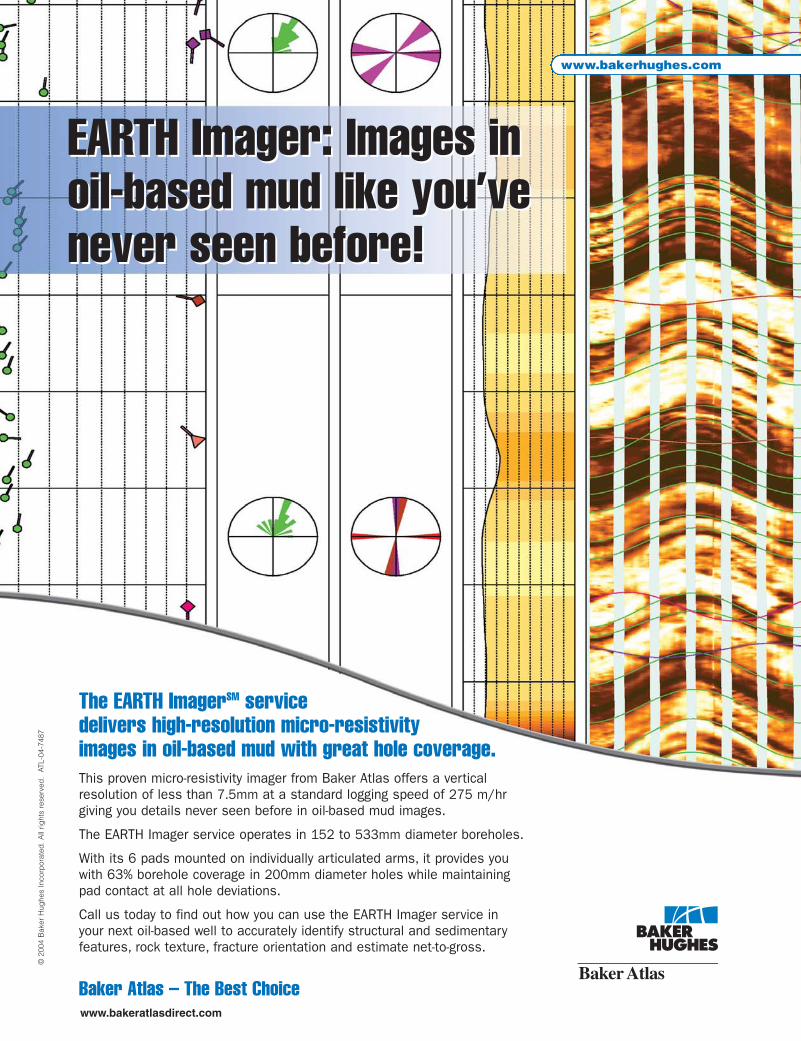
The EARTH ImagerSM servicedelivers high-resolution micro-resistivityimages in oil-based mud with great hole coverage.This proven micro-resistivity imager from Baker Atlas offers a vertical resolution of less than 7.5mm at a standard logging speed of 275 m/hrgiving you details never seen before in oil-based mud images.
The EARTH Imager service operates in 152 to 533mm diameter boreholes.
With its 6 pads mounted on individually articulated arms, it provides youwith 63% borehole coverage in 200mm diameter holes while maintaining pad contact at all hole deviations.
Call us today to find out how you can use the EARTH Imager service inyour next oil-based well to accurately identify structural and sedimentaryfeatures, rock texture, fracture orientation and estimate net-to-gross.
Baker Atlas – The Best Choice
EARTH Imager: Images inoil-based mud like you’venever seen before!
EARTH Imager: Images inoil-based mud like you’venever seen before!

RESERVOIR ISSUE 4 • APRIL 2008 19
DIVISION TALKS BASIN ANALYSIS DIVISION sponsored by
Sedimentology and stratigraphic framework of the Upper Clearwater Formation at Caribou Lake, AlbertaSPEAKERStuart C. TyeHusky Energy
12:00 NoonThursday, May 29, 2008EnCana Amphitheatre2nd Floor, east end of the Calgary Tower Complex1st Street and 9th Avenue SE, Calgary, Alberta
The Caribou Lake Oils Sands deposit is located approximately 70 kilometres northwest of Cold Lake, Alberta. Husky Energy has proposed a Thermal Demonstration Project for the area and the application is currently pending. Calculations indicate an Original Bitumen in Place (OBIP) for the 2.5 sections selected for the project of 220 million barrels. The project will aim to recover 1,590 m3/day (10,000 bpd) of bitumen.
The primary reservoir unit within the deposit is the Early Cretaceous (Albian) Clearwater Formation. It overlies the dominantly fluvial sand of the basal Cretaceous McMurray Formation and is overlain by the marine shale of the Grand Rapids Formation. To date, approximately 135 wells have been drilled in the Caribou Lake area that penetrate the Clearwater Formation and about 100 of these wells have been cored and analyzed.
The Clearwater Formation forms part of a broad, northwest-prograding depositional system comprising both deltaic and incised valley fill deposits. The lower part of the formation termed the Wabiskaw member directly overlies the McMurray Formation and comprises a coarsening-upward sequence interpreted as dominantly pro-deltaic to distal delta front deposits at the base and top of the succession,
respectively. Although the unit may be bitumen-saturated, low reservoir quality due to high shale content has deemed it non-prospective for the project.
The overlying succession within the Upper Clearwater Formation comprises a series of coarsening-upward regionally extensive deltaic regressive parasequences. In the Caribou Lake project area the regional sediments have been eroded by a northwest-southeast trending incised valley (termed Valley B). This valley may represent a complex fill comprising several amalgamated valley fills but the sand-dominated monotonous nature of the facies render the identification of sequence boundaries ambiguous. This valley fill constitutes the main bitumen reservoir on the lease and is interpreted as a transgressive tide-dominated estuarine deposit. The Clearwater Formation is capped by a significant transgressive surface and is overlain by marine mudstone at the base of the Grand Rapids Formation.
The two dominant reservoir facies within Valley B are subtidal sand bars and channels and comprise sporadically bioturbated dominantly fine- to medium-grained, cross-bedded and planar-laminated sandstone with subordinate thin- (mm-cm scale) to thick- (dm scale) laminated mudstone. These facies are confined to a fairway which extends parallel to the axis of the incised valleys through the central part of the lease and defines the focus area for the proposed development. Central estuary basin and/or marginal estuarine deposits form a third facies which is present in the eastern portion of the lease area and are generally non-prospective. This facies consists primarily of bioturbated, heterolithic mudstone and siltstone. The low diversity of trace fossils and the forms present (dominantly simple structures made by trophic generalists) are indicative of brackish water conditions and contrast markedly in character with the bioturbation present within the offshore marine shales of the regionally extensive deltaic regressive parasequences found outside of the valley complex.
Husky has completed the initial phase of delineation work to define the potential of its Caribou Lake oil sands. In December 2006, Husky submitted an application to Regulators which is currently under review by the AEUB and Alberta Environment. Delineation work started in 2005 with the drilling of in excess of 70 stratigraphic
wells. In Q1 2007 a three-component 3D seismic program was shot to assist in mapping the Clearwater Formation over the demonstration area.
BIOGRAPHYStuart Tye is the Clastic Specialist at Husky Energy. He received a B.Sc. (1991) and Ph.D. (1995) from the University of Wollongong and a B.Sc. (Honours) from James Cook University. He started his petroleum career working in Australia on numerous onshore and offshore basins before moving to Calgary with Husky Energy f ive years ago. He began his career at Husky in the International Exploration Department focussing for the most part on China before moving to his current position.
INFORMATIONBASS Division talks are free. Please bring your lunch. For further information about the division, to join our mailing list, to receive a list of upcoming talks, or if you wish to present a talk or lead a f ield trip, please contact either Steve Donaldson at 403-645-5534, email: [email protected] or Mark Caplan at 403-532-7701, email: [email protected] or visit our web page at www.cspg.org/events/divisions/basin-analysis-sequence-strat.cfm.

20 RESERVOIR ISSUE 4 • APRIL 2008
VOLUNTEER PROFILE:Talking with Travis Hobbs| by Heather Tyminski
TRAVIS HOBBS, CO-CHAIR OF THE EDUCATION COMMITTEEEmployer: EnCana CorporationPosition: Geologist
What is your current volunteer position at the CSPG?Currently I’m the Co-Chair of the Education Committee; I focus on coordinating short courses for the annual Convention and Education Week. In a similar role, the other Co-Chair, Krista Jewett coordinates field trips. This is my first long-term role with the CSPG
and I’ve been on the Education Committee for the past two years.
What are your current responsibilities as the Education Committee’s Co-Chair?I facilitate the Education Committee meetings and make sure that the subcommittees are working with each other. I’m also responsible for communication and long-term planning between the Education Committee and the Executive/CSPG Office to ensure we are meeting the training needs of the members and the incentives we offer instructors.
This committee provides an important service to the membership; smaller companies might not have dedicated geosciences training programs, which is why we offer additional training opportunities. We are responsible for creating affordable courses that provide good technical training for professionals.
The Education Committee practice is to the advantage of the instructors because the
committee and office staff handles registration, insurance, venues, and logistics. We also have set times for courses during the year so members can plan their training around our events, such as the Convention and Education Week.
How did the first Education Week go?There was a lot of learning involved with the first Education Week. It was held October 29 – November 2, 2007 so we could advertise along with the CSEG’s Doodle Train, an equivalent training opportunity for Professionals. We found that Education Week was well attended and appreciated by members, thus we are planning this to be an annual event.
Advertising for the event is a priority for us because the concept is still in its initial development. Convention courses which sell out can be held again at Education Week, along with additional courses not offered previously, so members get two opportunities per year to address their educational needs through the CSPG.
(Continued on page 28..)


22 RESERVOIR ISSUE 4 • APRIL 2008
*Injection and fall-off tests are analyzed the same way as a build-up – simply replace the production rate by the injection rate, and the pressure rise by the pressure fall.
RESERVOIR ENGINEERING FOR GEOLOGISTSPart 6 – Well Test Interpretation| by Louis Mattar, P. Eng. and Lisa Dean, P. Geol., Fekete Associates Inc.
Let’s start off with a simple situation:• Well A produces at 100 bopd from a reservoir
that contains 1 millions barrels of oil. • Well B also produces at 100 bopd from a reservoir
that also contains 1 millions barrels of oil. Are these two wells worth the same?
The answer is NO. This is because Well A is in a high permeability reservoir, but has a zone of reduced permeability around the wellbore (damage caused by drilling mud filtrate invasion or clay swelling). If this well were to be stimulated its rate would increase significantly. On the other hand, Well B is in a low permeability reservoir, which is the factor that limits its production rate.
How can we identify the differences between these two wells? The answer is well testing.
Well testing, often called pressure transient analysis (PTA), is a powerful tool for reservoir characterization. The following information can be extracted from well tests:
• Permeability – The value obtained from a well test is much more useful than that from core analysis, because it represents the in-situ, effective permeability averaged over a large distance (tens or hundreds of metres).
• Skin (damage or stimulation) – Most wells are either damaged or stimulated, and this has a direct effect on the deliverability of the well. The skin is a measure of the completion effectiveness of a well. A positive skin (typically +1 to +20) represents damage, while a negative skin (typically -1 to -6) represents improvement.
• Average reservoir pressure – This parameter, which is either measured directly or extrapolated from well test data, is used in material balance calculations for determining hydrocarbons-in-place.
• Deliverability potential – The IPR (inflow performance relationship) or the AOF (absolute open flow) is used in forecasting a well’s production.
• Reservoir description – Reservoir shape, continuity, and heterogeneity can be determined from pressure transient tests
• Fluid samples – The reservoir fluid composition and its PVT (pressure-volume-temperature) properties can have a significant effect on the economics and production operations.
Well testing is also an integral part of good reservoir management and fulfills government regulations.
FUNDAMENTALS:• A well test is a measurement of flow rate,
pressure, and time, under controlled conditions. While the well is flowing, the quality of the data is often poor, thus the data during a shut-in is usually analyzed.
• Opening or closing a well creates a pressure pulse. This “transient” expands with time, and the radius investigated during a test increases as the square-root of time. The longer the flow test, the further into the reservoir we investigate.
• Because of the diffusive nature of pressure transients, any values determined from a well test represent area averages and not localized point values.
• The analysis of oil well tests is similar to that of gas well tests. The theory is derived in terms of liquid flow, and is adapted for use with gas by converting pressure to “pseudo-pressure (�)” and time to “pseudo-time(ta).”
• The practice of testing a flowing oil well and a gas well is similar – measure the bottom-hole pressure. However, for a pumping oil well, it is often not easy to measure the bottom-hole pressure directly, so it is usually calculated from surface data and Acoustic Well Sounders, thereby having a greater potential for error.
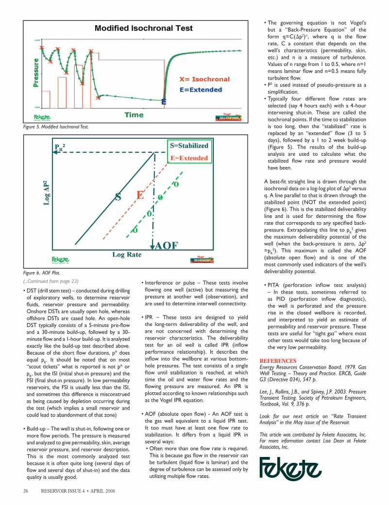
This article will concentrate on the analysis of the two most common well test types in Alberta, namely “build-up” and “deliverability” tests.
• Build-up test*: To conduct a build-up test, simply shut the well
in. It is obvious that a build-up test must be preceded by one or more flow periods. Figure 1 shows the simplest possible build-up, a shut-in that follows a single constant rate. In practice, the period preceding the buildup will often consist of variable rates, and even multiple flows and shut-ins. These non-constant flow periods cannot be ignored, but must be accounted
Figure 1. Drawdown and Build-up Test.
Figure 2. Semi-log (Horner) Plot of Build-up Data.

RESERVOIR ISSUE 4 • APRIL 2008 23
*In well testing the corrections caused by pseudo-time are usually negligible. For simplicity this article will use “t” rather than “ta”.
(Continued on page 26...)
for during the analysis. This is done through a mathematical process called superposition, which converts these variable flow periods into an equivalent constant rate.
• Deliverability tests: The purpose of these tests is to determine the
long term deliverability of a well, rather than defining the permeability and skin (as in build-up tests). There is one overriding factor in these tests; it is that at least one of the flow durations must be long enough to investigate the whole reservoir. This condition is known as “stabilized” flow. Sometimes it is impractical to flow a well for that long. In that case, the stabilized condition is calculated from the reservoir characteristics obtained in a build-up test.
INTERPRETATION:Interpretation of well test data is often conducted in two stages. The first is a diagnostic analysis of the data to reveal the reservoir model and the second is modeling of the test.
DATA PREPARATION:To analyze the build-up data, it is transformed into various coordinate systems in order to accentuate different characteristics. The most useful transformation is the “derivative” plot, obtained as follows:
1. Plot the shut-in pressure, p (for gas*, �) versus log {(t+�t)/ �t}, where t is the duration of the flow period (or the corresponding superposition time, when the flow period has not been constant) and �t is the shut-in time. A semi-log plot of this is called a Horner plot and is shown in Figure 2.
2. Determine the slope of the Horner plot at each �t. This slope is called the derivative.
3. Plot the derivative versus �t on log-log graph paper (Figure 3).
4. Calculate �p (for gas*, ��), the difference between the build-up and the last flowing pressure.
5. On the same log-log graph as the derivative, plot �p (for gas, ��) versus �t (Figure 3).
DIAGNOSTIC ANALYSIS:The buildup is divided into three time regions – early, middle, and late time. The middle time represents radial flow, and it is not until middle time is reached that the permeability can be determined. In Figure 2, the permeability is calculated from the slope of the semi-log straight line, and in Figure 3, from the vertical location of the flat portion of the derivative. These two answers should be the same.
The skin is calculated from the �p curve. In Figure 3, the larger the separation between the curves in the middle time region, the more positive is the skin.
Early time represents the wellbore and the near-wellbore properties (effects of damage, acidizing,
or hydraulic fracture). It is often associated with a (log-log) straight line of fixed slope. A slope equal to “one” means “wellbore storage,” and during that period, nothing can be learned about the reservoir because the wellbore is still filling up. A slope of “half” typically means linear flow as a result of a hydraulic fracture. From this straight line, the fracture length or fracture effectiveness can be calculated if the permeability is known.
The period after middle time is known as late time, and it reflects the effect of the reservoir boundaries and heterogeneities. It is from this region that the reservoir shape can be determined. A straight line of slope approximately “half” would indicate a long, narrow reservoir. A straight line slope approximately “one” could imply a low permeability reservoir surrounding the region investigated during middle time. If the derivative trends downward during the late time period, it could indicate an improvement in permeability (actually mobility) away from the well. If this downward curvature is severe, it might be indicative of a depleting reservoir.
The average reservoir pressure (pR) is obtained by extrapolating the semi-log straight line to infinite shut-in time (=1 on the Horner plot). This extrapolation is called p* and it is used, along with an assumed reservoir shape and size, to calculate the average reservoir pressure. For short flow durations, for example in a DST or in the initial test of a well, the correction from p* to pR is negligible, and p* does equal pR.
MODELING:Once the analysis has been completed and an approximate reservoir description deduced, a mathematical model of the reservoir is constructed. This model utilizes the production history of the test (all the flow and shut-in data) to generate “synthetic” pressures which are then compared with the pressures that were actually measured during the test (Figure 4). The values of the parameters in the model (permeability, skin, distances to boundaries, etc.) are varied until an acceptable match is obtained between the synthetic and measured pressures.
This process, called modeling or history matching, is a powerful mathematical tool, but must be used with caution, as it can result in mathematically correct, but physically meaningless answers. Some very complex reservoirs (multi-layers, heterogeneous, etc.) can be modeled using sophisticated mathematical models, but for these interpretations to be meaningful, they must be consistent with known geological descriptions and realistic physical well completions.
TYPES OF WELL TESTS:• RFT*, WFT*, MDT*, RCI*, FRT* – These
are tests of very short duration (minutes) conducted on a wireline, usually while the well is drilling. The popular use is for determining the reservoir pressure at various depths.
Figure 3. Derivative Plot of Build-up Data.
Figure 4. Modeling: Comparison of Synthetic and Measured Pressures.
*Trade Marks: RFT=Repeat Formation Tester, WFT=Wireline Formation Tester, MDT=Modular Dynamic Tester, RCI= Reservoir Characterization Instrument, FRT=Flow Rate Tester

PETRA®
“With PETRA I can generatewater saturation curves andupdate HPV maps within minutes of receiving digital logs. Now that’s staying astride of your drilling!”
Get real-time log analysis. PETRA provides multi-discipline reservoir
management teams with the analysis tools needed for today’s
exploration, exploitation and acquisition challenges.
©2008 IHS Inc. All rights reserved.
Christopher Collom, Ph.D.Senior GeologistenerPLUS Resources Fund
“Constructing structural orstratigraphic cross-sectionsin PETRA is efficient, seamless,and has virtually endlesscustomization options.A great tool!”
Download your free PETRA trialat ihs.com/petraconnect
Nadeem Muhammad, M.Sc.Geologist
enerPLUS Resources Fund

Strip LogStrip Log
Horizontal LogHorizontal Log
Mud LogMud Log
Log ViewerLog Viewer
Log ManagerLog Manager
200, 900200, 900——6th Ave SW, Calgary, Alberta T2P 3K2 6th Ave SW, Calgary, Alberta T2P 3K2 [email protected] [email protected] 1--800800--447447--1534 (403) 2371534 (403) 237--91899189
Log AnalysisLog Analysis
www.rpsgroup.com/energy(403) 263-0449
1708
4
Global Leaders in Wellsite GeologyServing the petroleum industry for over 25 years
■■ Conventional Vertical / Horizontal Wells
■■ Unconventional Heavy Oil / CBM Wells
■■ International WSG / Operations Geology

28 RESERVOIR ISSUE 4 • APRIL 2008
What is involved in planning courses for the Annual Convention?This mainly involves organizing the logistics of the courses and the venues. For 2008 we will be organizing 14 short courses and 8 field trips. Previously, the CSPG had a short course committee for the Conventions and a separate Education Committee to handle courses for the rest of the year. Last year these two committees were combined which adds a level of consistence and stability from year-to-year as well as a standardized educational objective.
What other volunteer positions have you held in the past at the CSPG?I have helped out at CSPG conventions and Core Conferences when they needed extra help. I’ve have also presented several posters and core displays at the annual Convention.
Why did you initially decide to volunteer?My decision to volunteer had to do with the mentorship I was receiving from Doug Hamilton (a former CSPG Programs Director). Doug mentioned a need for new volunteers and what positions were currently available. Personally I felt that after a few years of working, I had more time to give back to the Society.
I chose the Education Committee because of
the role it plays. The Education Committee is especially important to those members who are not working for bigger companies with long-term dedicated educational resources available to new graduates and the continued development of industry professionals.
Why have you continued to volunteer?I enjoy the challenge in trying to build new ideas and personal development. It was an opportunity to help build a committee which was going through some significant changes; in the past year alone we went from four volunteers to eight on the Education Committee. We now have volunteers in defined roles and responsibilities working to address the short- and long-term training needs of members.
I also volunteer because of the people I get to work with; I find you develop friendships with some excellent people who are passionate about their career and scientific background. It’s also a great way to say in touch with acquaintances/industry contacts and to do something constructive with your time.
What are some memorable moments you have had as a volunteer?Setting up the first Education Week is pretty memorable because it was a huge learning experience. I found I took away a lot of project
management experience from planning the event. Every time we finish a Convention is also memorable, especially when the members are really happy about what you’ve offered them and that all the hard work and planning has paid off.
Could you offer some words of wisdom to our CSPG members?Don’t be afraid to try volunteering. The advantage of volunteering is you get to build strong skill sets in your spare time and for the most part people don’t expect perfection, just good intentions.
What is your opinion of current volunteerism at the CSPG?The CSPG could always benefit from more volunteers, simply because the more volunteers we have, the less work individuals have put on them, which at times can be draining. At the same time, the people that currently volunteer are fantastic because they are active and they want to make a positive difference.
We all benefit from working together because we have an opportunity to exchange ideas. Find an area that challenges you; there are many different committees to choose from and lots of benefits associated with volunteering.
(...Continued from page 20)

RESERVOIR ISSUE 4 • APRIL 2008 29
Table 1. Sedimentological description of the OFP and its members. Turbidite divisions from Stow and Shanmugam (1980) or Bouma (1962).
THE NEOPROTEROZOIC OLD FORT POINT FORMATION,Southern Canadian Cordillera| by Mark D. Smith, R.W.C. (Bill) Arnott, and G.M. Ross
PART 2: SEDIMENTOLOGY AND SEQUENCE STRATIGRAPHIC FRAMEWORK
INTRODUCTIONThe Neoproterozoic Windermere Supergroup (WSG) is a thick (~9 km), continental margin sedimentary succession exposed in a series of thrust panels in the Main Ranges of the western Fold-and-Thrust Belt and the Omineca Belt of the southern Canadian Cordillera (see Arnott and Ross, 2008 for full description). In southwestern Canada, the WSG is composed primarily of deep-marine siliciclastic sandstone and mudstone with subordinate carbonate and mafic volcanic rocks. Within this backdrop of stratal monotony is the lithologically and geochemically distinctive Old Fort Point Formation (OFP). As discussed in Part 1, the OFP is recognized by its distinctive colours and lithologies and is subdivided into three stratigraphically ascending members: Temple Lake Member (TLM), Geikie Siding Member (GSM), and Whitehorn Mountain Member (WMM). Each member is composed of a characteristic suite of lithofacies interpreted to be deposited by a variety of deep-marine transport processes. The purpose of this paper is to summarize the main sedimentologic and stratigraphic elements of the OFP, describe its evolution in a sequence stratigraphic framework, and
outline its important link to globally recognized Neoproterozoic glacial events.
SEDIMENTOLOGIC AND STRATIGRAPHIC ELEMENTSThe OFP is a mostly fine-grained marker unit that breaks up an otherwise immature, coarse-grained siliciclastic succession in the WSG. Early correlations of the OFP by Charlesworth, Gussow, and Aitken were based primarily on its distinctive purple and green colours. The overall thickness of the OFP ranges from approximately 60 to 450 m, but typically is of the order of 60 to 125 m thick. The TLM (50 to 125 m) and GSM (2 to 12 m) are fairly constant in thickness across the Windermere basin, which contrasts the WMM that ranges from <1 to ~165 m. Details of the main sedimentologic features of each member are provided in Table 1 and briefly summarized below.
In most sections, contacts between the OFP and the enveloping WSG strata are sharp and easily recognized where there is a significant change in grain size (e.g., fine-grained OFP strata bounded above and below by the coarse “grit” units) or mineralogical composition (e.g., WMM quartz arenite overlain by WSG immature arkose). Although the distinctive colour change in the basal TLM
provides an easily recognizable contact with the underlying WSG, these fine-grained facies contacts are usually gradational in nature, over a small interval of less than 0.5 m.
The basal TLM consists primarily of immature siltstone-mudstone with isolated carbonate-cemented sandstone beds that grade upward into rhythmic limestone-siltstone packages (Figure 1A, 1B). It is overlain by the GSM, a dark-coloured, organic-rich mudstone-pelite (Figure 2). The contact between the TLM and GSM is usually gradational, and in most outcrops occurs over a discernible transition zone <0.5 – 5 m thick. The transition is marked by an upward-fining trend, a decrease in limestone bed frequency, and a number of measurable geochemical changes (see below). The recognition of these two units and their consistent stratigraphic order, in addition to punctuating two coarse-grained WSG units, facilitated its widespread correlation throughout the southern Canadian Cordillera (e.g., Ross and Murphy, 1988).
The GSM is characterized by elevated TOC (total organic carbon) values and distinctive chemical and isotopic signatures compared to other fine-grained units in the WSG. For example, the GSM has consistently higher
(Continued on page 30..)

30 RESERVOIR ISSUE 4 • APRIL 2008
Figure 1. Limestone – siltstone rhythmites of the Temple Lake Member. A) Vista Glacier, Mount Robson Provincial Park. B) Geikie Siding, Jasper National Park. Metre-stick for scale.
TOC values (~0.4% to 4%) compared to the more typical WSG mudstone-pelite units (<0.3%) (Figure 3A). It is important to note that these concentrations are AFTER low-grade metamorphism, suggesting that the TOC at deposition was of the order of 4X the present values and therefore between ~2% to 10%, suggesting it would have had significant source-rock potential. In addition, the GSM is also characterized by a consistent enrichment in redox-sensitive trace-element concentrations (e.g., Mo, V, Sb) when compared to typical WSG mudstone-pelite units (Figure 3A, 3B).
Lithologically, the WMM is the most complex of the OFP members. Unlike the TLM and GSM, it consists of a diverse assemblage of lithofacies, which commonly are location-specific (Figure 4A-D). The base is always
sharp and locally deeply scoured having removed portions of the GSM and TLM. In places where the GSM and TLM are completely eroded, the WMM overlies directly strata of the underlying WSG. On the other hand, where the WMM is thinly developed and the GSM appears to grade into mudstones of the WSG, the contact is extremely difficult to recognize in outcrop and may require the use of other techniques (e.g., gamma ray or geochemistry) to identify its location.
DEPOSITIONAL MODEL AND SEQUENCE STRATIGRAPHIC FRAMEWORKThe OFP was deposited along a deep-marine basin-slope to basin-floor transect and is sandwiched between two thick units of WSG coarse-grained turbidites (Figure 5). Fine-grained, mostly turbiditic strata of the TLM
and GSM are regionally uniform in thickness and lithofacies, have gradational contacts, and imply synchronous, basin-wide deep-marine sedimentation. They are interpreted to be related to a post-glacial eustatic rise (2nd or 3rd order) that caused an overall shutdown of coarse, immature siliciclastic sediment supply to the basin (Ross and Murphy, 1988). Conversely, the WMM is locally variable with sharp, commonly erosive contacts with deposition potentially controlled by a combination of paleogeographic location, topography within the basin, structural activity and/or relative sea-level changes.
The siltstones and limestone-siltstone rhythmites of the TLM are interpreted to have been deposited during a rapid rise of relative sea level (transgression) due to glacial melting (Figure 5). The maximum regressive surface,
Figure 2. Black mudstone/pelite of the Geikie Siding Member, Cariboo Mountains. Metre-stick for scale.
Figure 3. Geochemical diagrams of OFP-GSM compared to typical WSG mudstone units from southern Canadian Cordillera. A) Total organic carbon (TOC) vs. Molybdenum (Mo). B) Vanadium (V) vs. Titanium (Ti).
(...Continued from page 29)

RESERVOIR ISSUE 4 • APRIL 2008 31
representing the switch from regressive to transgressive deposition occurs below (not at) the base of the TLM. Fine-grained strata of the TLM are slightly more silt-rich than the underlying WSG mud-prone units and are interpreted to be distal glaciomarine turbidites sourced from physically weathered (glacial action) material. The distinctive purple colour (from diagenetic hematite) in the siltstone is the result of the voluminous input of oxygen-rich, glacial meltwater. Purple-coloured units grade vertically into green-coloured units (reducing) implying a progressive shift from oxic to reducing conditions with the ongoing relative sea-level rise (transgression). The siltstone grades upward into the limestone – siltstone rhythmites with limestone beds becoming more abundant and increasing in calcite percent up-section. The limestone beds are composed of fairly pure calcite (low trace-element concentrations) that was periodically eroded from upslope shallow-
marine carbonate source and remobilized into the basin by turbidity currents. The rhythmic nature may be climatically controlled and current research is assessing if any cyclic frequencies can be identified from these strata (Figure 1). The gradational contact of the TLM into the GSM is marked by an upward-fining trend and a decrease in limestone beds.
The organic-rich ~608 Ma GSM (Kendall et al., 2004) is interpreted to have been deposited during the terminal trangressive phase and the onset of earliest highstand conditions (Figure 5). The regionally extensive, basin-wide maximum flooding surface occurs within the condensed section of the GSM, representing the maximum shoreline transgression, shutdown of the carbonate factory, and possibly the deepest water conditions in the entire WSG succession. In the basin, slow rates of sedimentation (e.g., thin lamination) permitted
concentration and preservation of organic matter and select trace elements (e.g., Mo, V, Sb) under low oxygen levels. The potential for anoxia was further enhanced by releases of large volumes of glacial meltwater during the rapid rise in sea level, which would have led to abrupt short-term water column stratification and development of anoxic (?) bottom waters throughout the basin. Organic-rich strata of the GSM would have represented a world-class deep-marine source-rock horizon that may have charged parts of the enveloping turbidites of the WSG.
Deposition of the WMM is interpreted to have coincided with an abrupt fall in relative sea level caused, at least in part, by post-glacial uplift, which temporarily interrupted the long-term rise of relative sea level (Figure 5). The sharp base of the WMM is usually a surface of erosion and may represent a
(Continued on page 32..)

32 RESERVOIR ISSUE 4 • APRIL 2008
basal surface of forced regression. In slope settings, the sediment transport pathways are controlled by the location of submarine canyons (e.g., Lake Louise, Jasper) or a combination of canyons, syn-sedimentary growth faults, and paleo-seafloor topography (e.g., Purcell Mountains, McKale River). Coarse-grained slope lithofacies are generally confined to the canyons and consequently are laterally discontinuous with a wide thickness range. With the onset of relative sea-level fall, deposits consist of intraformational TLM carbonate-clast diamictites derived from canyon-wall collapse. Subsequently, canyons were filled during lowstand and transgression by mudstone-siltstone, sandstone, and breccia-conglomerate units characterized by a diverse range of clasts eroded from upslope sediment sources including shallow-marine carbonates. At some locations, the WMM is dominated by turbidites consisting of quartz arenite interbedded with dark limestone (e.g., Purcell Mountains, McKale River). The quartzose framework composition of the sandstones contrast the typical background WSG turbidites rich in feldspar, and reflect winnowing and maturation from residence on the shelf during the earlier transgression and highstand. The dark limestone associated with the quartz arenite suggests the development of an active upslope carbonate factory during relative highstand conditions, perhaps located over pre-existing paleo-topographic highs (e.g., Montania near Purcell Mountains). At these locations, turbidite strata exhibit rhythmic upwards changes in bed thickness and framework composition (e.g., percent carbonate vs. quartz) suggesting a higher order relative sea-level control that may not be observable at locations where the WMM is thinly developed (e.g., Mount
Robson). The thickness of the WMM and persistence of soft-sediment deformation features suggests fairly rapid deposition and delivery of a significant volume of coarse-grained sand during the continued sea-level rise. Basinal sections of the WMM (e.g., Cariboo Mountains) consist of calcareous and quartz arenite turbidites and may represent a combination of lowstand, transgressive, and highstand deposits depending on how slope to basin lithologic correlations are interpreted.
An interesting feature of the OFP is that irrespective of thickness, it overlies and is overlain by the same coarse- and fine-grained WSG lithologies. This, in spite of the exceptional geological (lithological and geochemically) occurrence of the OFP, suggests no significant progradation or retrogradation of the shelf margin during OFP time and that sedimentary conditions returned to much the same state following deposition of the OFP.
The OFP has been interpreted as a post-glacial deep-water succession equivalent to better-studied glacigenic diamictites (e.g., Aitken, 1991; McMechan, 2000) and cap carbonates (e.g., James et al., 2000) exposed in north-central British Columbia and the Mackenzie Mountains, N.W.T. (e.g., Ross et al. 1995). The TLM rhythmic limestone-siltstone couplets are interpreted as a deep-marine equivalent of the cap carbonates of the Vreeland (McMechan, 2000) and Ice Brook formations (James et al., 2001). The correlation between the three formations is based primarily on lithostratigraphic relationships and the consistent occurrence of carbonates with a distinctive bladed calcite crystal habit (e.g., Ross et al., 1995). Current research is focused on integrating
stratigraphic disciplines (litho-, chemo-, and sequence stratigraphy) to strengthen the regional WSG correlation and understand the importance of the OFP in the context of global Neoproterozoic glacial events.
REFERENCESAitken, J. D. 1991. Two late Proterozoic glaciations, Mackenzie Mountains, northwestern Canada. Geology, v. 19, p. 445-448.
Arnott, R. W. C. and Ross, G. M. 2008. Overview of the (Neoproterozoic) Windermere Supergroup of the southern Canadian Cordillera. Canadian Society of Petroleum Geologists, Reservoir v. 35, issue 2, p. 35-38.
Bouma, A. H. 1962. Sedimentology of some flysch deposits. Elsevier, Amsterdam, 168 p.
James, N. P., Narbonne, G. M., and Kyser, T. K. 2001. Late Neoproterozoic cap carbonates; Mackenzie Mountains, northwestern Canada; precipitation and global glacial meltdown. Canadian Journal of Earth Sciences, v. 38, p. 1229-1262.
Kendall, B. S., Creaser, R. A., Ross, G. M., and Selby, D. 2004. Constraints on the timing of Marinoan “Snowball Earth” glaciation by 187Re-187Os dating of a Neoproterozoic, post-glacial black shale in Western Canada. Earth and Planetary Science Letters, v. 222, p. 729-740.
McMechan, M. E. 2000. Vreeland diamictites; Neoproterozoic glaciogenic slope deposits, Rocky Mountains, Northeast British Columbia. Bulletin of Canadian Petroleum Geology, v. 48, p. 246-261.
Ross, G.M. and Murphy, D.C. 1988. Transgressive stratigraphy, anoxia, and regional correlations within the late Precambrian Windermere grit of the southern Canadian Cordillera. Geology, v. 16, p. 139-143.
Ross, G. M., Bloch, J. D., and Krouse, H. R. 1995. Neoproterozoic strata of the southern Canadian Cordillera and the isotopic evolution of seawater sulfate. Precambrian Research, v. 73, p. 71-99.
Stow, D.A.V. and Shanmugam, G. 1980. Sequence of structures in fine-grained turbidites; comparison of recent deep-sea and ancient flysch sediments. Sedimentary Geology, v. 25, p. 23-42.
(Continued on page 34..)
Figure 4. Lithofacies of the Whitehorn Mountain Member. A) Mudstone – siltstone, Lake Louise. B) Interbedded arenaceous limestone and quartz arenite, Purcell Mountains. C) Carbonate-clast breccia-conglomerate, Lake Louise. D) Coarse-grained breccia-conglomerate and quartz arenite, McKale River, B.C.
(...Continued from page 31)

RESERVOIR ISSUE 4 • APRIL 2008 33
Figure 5. Schematic depositional model, sequence stratigraphic framework and composite stratigraphic section of the OFP. Abbreviations: TST – trangressive systems tract; CS – condensed section; HST – highstand systems tract; FSST – falling-stage systems tract; LST – lowstand systems tract; BSFR – basal surface of forced regression; MFS – maximum flooding surface; MRS – maximum regressive surface; SB – sequence boundary.


RESERVOIR ISSUE 4 • APRIL 2008 35
Reservoir ImagingExpertise in heavy oil & deep basin reservoirs
Hart JanssenB.Sc., Manager, Seismic ProcessingDirect: 403-260-3372 Main: 403-237-7711www.sensorgeo.com
• Time Lapse (4D) Processing
• 4D Cross Equalization
• Multicomponent (3C, 4C) Processing
• 3D Merging
• PSTM with Common Offset Vector Binning
2008 CSPG CSEG CWLS CONVENTIONSpecial Events
MONDAY, MAY 12th
BREAKFAST WITH EXHIBITORS8:00 am – 10:00 am
Exhibit Floor – Halls A & BGet a chance to wander through the exhibits and enjoy a complimentary continental breakfast and coffee.
LUNCH WITH THE EXHIBITORS11:30 am – 1:00 pm
Exhibit Floor – Halls A & B New to the Convention this year is a complimentary buffet lunch on the Exhibit Floor. No need to venture off the grounds for a bite to eat.
ICEBREAKER RECEPTION4:00 pm – 7:30 pm
Exhibit Floor – Halls A & BSponsored by: Devon Canada Corporation
Join your colleagues for some great food and conversation while browsing the many exhibits at this year’s CSPG CSEG CWLS Conference.
TUESDAY, MAY 13th
BREAKFAST WITH EXHIBITORS8:00 am – 10:00 am
Exhibit Floor – Halls A & BGet a chance to wander through the exhibits and enjoy a complimentary continental breakfast and coffee.
LUNCH WITH THE EXHIBITORS11:30 am – 1:00 pm
Exhibit Floor – Halls A & BNew to the Convention this year is a complimentary buffet lunch on the exhibit floor. No need to venture off the grounds for a bite to eat.
BEER & BULL4:00 pm – 6:00 pm
Exhibit Floor – Halls A & BSponsored by: Divestco Inc.
Enjoy the final hours of the Exhibition with a drink and appetizers as you network with colleagues.
TUESDAY, MAY 13th
LONG TIME MEMBERS RECEPTION
4:00 pm – 6:00 pmRotary House
Have you been a member of the CSPG for 30+ years? If so, this event is for you! In appreciation for their long commitment to the Society, the CSPG will host the 8th Annual Long Time Members Reception, a complimentary cocktail party for our more senior members.
STUDENT/INDUSTRY GALA & CHALLENGE BOWL
4:00 pm – 6:00 pm Boyce Theatre – Stampede Park
Sponsored by: Zokero Inc.Meet the energetic minds of tomorrow, as graduates have the opportunity to meet industry representatives from the companies that will employ them. Strike up new relationships and wander into the theatre to take in the always entertaining Challenge Bowl competition.
Only YOU can enjoy the Core Meltdown.
(Continued on page 36..)
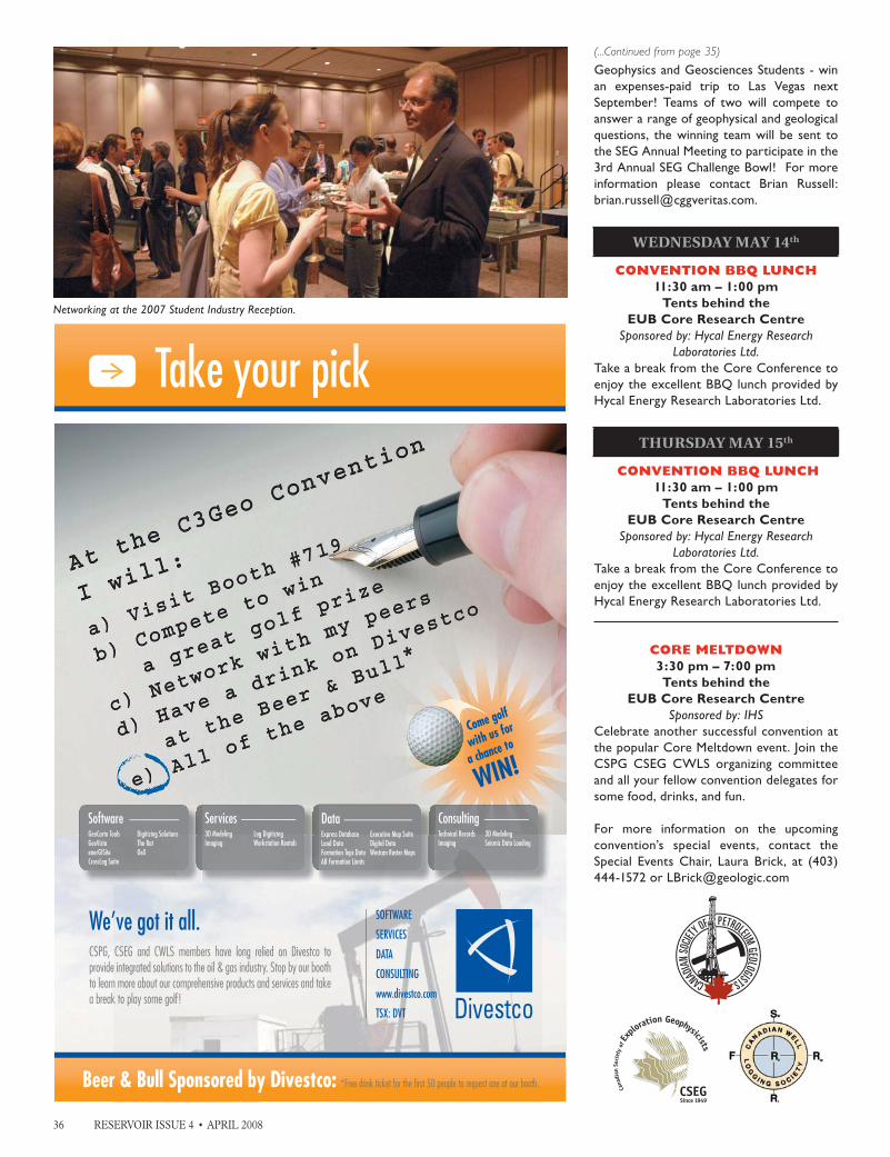
36 RESERVOIR ISSUE 4 • APRIL 2008
Geophysics and Geosciences Students - win an expenses-paid trip to Las Vegas next September! Teams of two will compete to answer a range of geophysical and geological questions, the winning team will be sent to the SEG Annual Meeting to participate in the 3rd Annual SEG Challenge Bowl! For more information please contact Brian Russell: [email protected].
WEDNESDAY MAY 14th
CONVENTION BBQ LUNCH11:30 am – 1:00 pm
Tents behind the EUB Core Research Centre
Sponsored by: Hycal Energy Research Laboratories Ltd.
Take a break from the Core Conference to enjoy the excellent BBQ lunch provided by Hycal Energy Research Laboratories Ltd.
THURSDAY MAY 15th
CONVENTION BBQ LUNCH11:30 am – 1:00 pm
Tents behind the EUB Core Research Centre
Sponsored by: Hycal Energy Research Laboratories Ltd.
Take a break from the Core Conference to enjoy the excellent BBQ lunch provided by Hycal Energy Research Laboratories Ltd.
CORE MELTDOWN3:30 pm – 7:00 pm Tents behind the
EUB Core Research CentreSponsored by: IHS
Celebrate another successful convention at the popular Core Meltdown event. Join the CSPG CSEG CWLS organizing committee and all your fellow convention delegates for some food, drinks, and fun.
For more information on the upcoming convention’s special events, contact the Special Events Chair, Laura Brick, at (403) 444-1572 or [email protected]
SOFTWARE
SERVICES
DATA
CONSULTING
www.divestco.com
TSX: DVT
We’ve got it all.CSPG, CSEG and CWLS members have long relied on Divestco to provide integrated solutions to the oil & gas industry. Stop by our booth to learn more about our comprehensive products and services and take a break to play some golf!
Take your pick
Come golf
with us for
a chance to
WIN!
ConsultingTechnical RecordsImaging
3D ModelingSeismic Data Loading
DataExpress DatabaseLand DataFormation Tops DataAB Formation Limits
Executive Map SuiteDigital DataWestcan Raster Maps
Services3D ModelingImaging
Log DigitizingWorkstation Rentals
SoftwareGeoCarta ToolsGeoVistaenerGISiteCrossLog Suite
Digitizing SolutionsThe RatOeX
Beer & Bull Sponsored by Divestco: *Free drink ticket for the fi rst 50 people to request one at our booth.
Networking at the 2007 Student Industry Reception.
(...Continued from page 35)

To us, it’s all about making your career
a big success.
For more info or to enroll call +1 918 560-2650 or visit http://www.aapg.org/aug/
More science than you can shake a pick at.
Exploration in Stratigraphic Traps
Choose from over 50 exciting field seminars and short courses all designed with the goal of helping you explore and better understand your industry. For complete details on any of the field seminars and short courses offered by the AAPG, call +1 918 560-2650 or visit http://www.aapg.org/education/
SHORT COURSESPractical Salt TectonicsDate: May 5-6, 2008Location: London, EnglandInstructor: Mark G. Rowan, Consultant, Boulder, COhttp://www.aapg.org/education/shortcourse/details.cfm?ID=67
Basic Well Log AnalysisDate: May 13-16, 2008Locations: Austin, TX Instructors: George B. Asquith, Texas Tech University, Lubbock, TX; Daniel A. Krygowski, The Discovery Group, Denver, COhttp://www.aapg.org/education/shortcourse/details.cfm?ID=109
Essentials of Subsurface MappingDate: May 19-20, 2008Location: Dallas, TXInstructor: Richard Banks, Scientific Computing Applications, Inc., Tulsa, OKhttp://www.aapg.org/education/shortcourse/details.cfm?ID=29
Deep-Water Sands - Integrated Stratigraphic Analysis: A Workshop Using Multiple Data SetsDate: May 26-28, 2008Location: London, EnglandInstructor: John M. Armentrout, Cascade Stratigraphics, Damascus, ORhttp://www.aapg.org/education/shortcourse/details.cfm?ID=52
Reservoir Engineering for Petroleum GeologistsDate: May 28-29, 2008Location: Houston, TXInstructor: Richard G. Green, Saxon Oil, Dallas, TXhttp://www.aapg.org/education/shortcourse/details.cfm?ID=71
Exploring for Stratigraphic Traps Using Pressure/Depth Plots & SalinitiesDate: June 2-4, 2008Location: Denver, COInstructor: Hugh Reid, Hugh W. Reid & Associates, Calgary, AB, Canadahttp://www.aapg.org/education/shortcourse/details.cfm?ID=49
Multi-Component Seismic StratigraphyDate: June 11-12, 2008Location: Houston, TXInstructor: Bob Hardage, Bureau of Economic Geology, Austin, TXhttp://www.aapg.org/education/shortcourse/details.cfm?ID=42
Seismic Interpretation in Fold- and Thrust-Belts Using Fault-Related Folding TechniquesDate: June 17-20Location: Denver, COInstructor: John Shaw, Harvard University, Cambridge, MA
FIELD SEMINARS
Modern Terrigenous Clastic Depositional SystemsDates: May 1 - 8; June 14 - 21, 2008Location: Begins in Columbia and ends in Charleston, South CarolinaLeader: Walter J. Sexton, Athena Technologies, Inc., Columbia, SChttp://www.aapg.org/education/fieldseminars/details.cfm?ID=6
Submarine Canyons, Channels, Fans and Deep-water Sequence StratigraphyDate: May 4-7, 2008 (beginning at noon on the 4th, ending late afternoon on the 7th)Location: La Jolla, San Deigo County, CaliforniaLeader: John E. Warme, Colorado School of Mines, Golden, COhttp://www.aapg.org/education/fieldseminars/details.cfm?ID=63
Controls On Porosity Types and Distribution in Carbonate ReservoirsDate: May 18-23, 2008Location: Almeria Region, SE Spain, begins and ends in Las Negras, Spain. Fly from London/Barcelona/MadridLeaders: Evan K. Franseen, Kansas Geological Survey, Lawrence, KS; Robert H. Goldstein, University of Kansas, Lawrence, KS; Mateu Esteban, REPSOL-YPF, Mallorca, Spainhttp://www.aapg.org/education/fieldseminars/details.cfm?ID=2
Complex Carbonate Reservoirs: The Role of Fracturing, Facies and TectonicsDate: May 24-30, 2008 (begins the afternoon of May 24 and finishes the afternoon of May 30)Location: Begins in Naples and ends at Rome International Airport (Italy)Leaders: Raffaele Di Cuia, G.E.Plan Consulting, Ferrara, Italy; Davide Casabianca, BP plc, Aberdeen, UKhttp://www.aapg.org/education/fieldseminars/details.cfm?ID=79
GEOTOUR! Geological Tour Through Alaska: A Trans-Alaskan Transect - Gulf of Alaska to Prudhoe Bay on the Arctic OceanDate: May 31 - June 10, 2008Location: Trip begins in Homer and ends in Fairbanks, AlaskaLeaders: Tom Plawman, BP, Anchorage, AK, and David Hite, Consultant, Anchorage, AK, for south-central Alaskan segment; Gil Mull, Santa Fe, N.M., Tom Plawman and David Hite for Brooks Range and northern Alaska segmenthttp://www.aapg.org/education/fieldseminars/details.cfm?ID=113
Predicting Clastic Reservoirs Using Applied Sequence StratigraphyDate: June 7-14, 2008Location: Begins and ends in Salt Lake City, UTLeaders: Lee F. Krystinik, Fossil Creek Resources, Fort Worth, TX and Beverly Blakeney De-Jarnett, Bureau of Economic Geology, The University of Texas, Houston, TXhttp://www.aapg.org/education/fieldseminars/details.cfm?ID=11
Folding, Thrusting & Syntectonic Sedimentation: Perspectives from Classic Localities of the Central PyreneesDate: June 16-20, 2008Location: Begins and ends in Barcelona, SpainLeaders: Antonio Teixell, Universitat Autonoma de Barcelona, Spain, and Antonio Barnolas, Instituto Geologico y Minero de Espana, Madrid, Spainhttp://www.aapg.org/education/fieldseminars/details.cfm?ID=24
Sequence Stratigraphy and Reservoir Distribution in a Modern Carbonate Platform, BahamasDate: June 16-20, 2008Location: Begins and ends in Miami, Florida. Four days are spent on a chartered boat in the Bahamas.Leaders: Gregor P. Eberli, Comparative Sedimentology Laboratory, University of Miami, Mi-ami, FL; G. Michael Grammer, Department of Geosciences, Western Michigan University, Kal-amazoo, MI; Paul M. (Mitch) Harris, Chevron Energy Technology Company, San Ramon, CAhttp://www.aapg.org/education/fieldseminars/details.cfm?ID=4
(...

38 RESERVOIR ISSUE 4 • APRIL 2008
TIME TO START THINKING about the 2008 CSPG Long-Time Members’ Reception| by Regan Palsgrove
Have you been a member of the CSPG for 30+ years (since at least 1978)?
If so, keep an eye open for your invitation to the 8th Annual Long-Time Member’s Reception. The very popular event is a complimentary cocktail party organized exclusively for our more senior members, in appreciation of their long commitment to the Society. Attendance is by invitation only.
This year the reception will take place on Tuesday, May 13, 2008 from 4:00 pm – 6:30 pm, and will be held, once again, at the lovely Rotary House on the Stampede Grounds. It will be held in conjunction with the Back to Exploration Convention, but you need not be registered for the convention in order to attend the Long-Time Members Reception. Invitations will be sent out in mid to late April.
If you are a long-time member (30+ years) in good-standing, and have not received an invitation by May 1, please contact the CSPG office (403-264-5610). The office can verify your start-date, and make sure your name is included on the invitation list. Included with the invitation will be a list of all other invitees – you can look for your friends’ names and help us make sure no one is omitted. It also makes a great “cheat sheet” for the reception when you run into all those old acquaintances!
This event is highly anticipated, and every year more people attend. We have lots of tasty hors d’oeuvres, a couple of a complimentary drink tickets, a cash bar, door prizes, and special prizes for the attendees with the earliest start-dates. Last year, about 170 people attended. We have a short, informal agenda, which includes the presentation of the 2007 Honorary Membership Awards. This year the recipients will be Dr. Phil Simony and Dr. Neil Hutton.
We hope you can make it to this year’s Long-Time Members Reception! For more information regarding this event, please contact Regan Palsgrove at Talisman Energy; phone (Tues. to Thurs.) (403) 237-1423 or e-mail [email protected].
Long-time members, Andrichuck, Williams, Klovan, and Bray.
Long-time members, G. Grant and M. Stanton.
Long-time gathering.
Long-time members, A. Payne and C. Longlo.


40 RESERVOIR ISSUE 4 • APRIL 2008
25TH ANNIVERSARY TOURNAMENT Makes a Big Racket!| by David Caldwell
Touted as the tourney of all tourneys, the CSPG 25th Anniversary Squash Tourney may have been the best event yet. Calgary’s longest-running squash tournament was promoted as a special year because we celebrated the event’s 25th Anniversary. Once the dust had settled and participants woke from a memorable or partly memorable banquet celebration, there should have been no doubt that the pain of competition and joy of camaraderie over the past three days was well worth it.
Most of the tournament’s success can be attributed to the many generous sponsors. Once again, Tucker Wireline Services stepped in as Tournament Sponsor with a large cash donation, as well as sponsoring the practice nights and registration night at the Bow Valley Club. Weatherford Canada, Baker Hughes, and Geotir Inc. also generously supported the tournament, donating $1,500 each for the event.
There was an increase in the number of gold-level sponsors this year. Belloy Petroleum Consulting and Divestco Inc. generously renewed their gold sponsorship levels. Genesis Executive Corp. jumped from a Silver sponsor to the gold level. Halliburton Energy Services, Lyons Oilfield Scouting, Pulse Date Inc., and Sanjel Corporation became new sponsors at the $1,000 level.
The increase in sponsor money allowed for bigger and better highlights during the
tournament. Thursday night finger food became ‘Pizza and Calzone Night’. Saturday muffins and coffee were upgraded to a full brunch including a customized omelet station and a wild-game meat chili. Long sleeve shirts were also added to recognize sponsors who had contributed towards the event.
A newly built doubles squash court at the World Health Club in Edgemont was a huge hit. Nearly half of the tournament’s participants played both singles and doubles while others got to try the sport out by filling in for players during the tournament.
Gord Copp and James Muraro won the inaugural Competitive Doubles Division while committee members Kristy Howe and David Caldwell took the Recreational Doubles Crown.
Other highlights featured a changing of the guard in the Men’s A Division as young newcomer Ian Laycock breezed into the final to oust his previously unbeaten rival, Dave Safton, 3-0. Hilary Foulkes made a triumphant return to the tourney winning the Women’s A Division after several years of retirement.
Special thanks to: EnCana for their generous sponsorship of our student participants, Baker Hughes for the always fun and hilarious “Teams Tourney,” Geotir Inc. for making sure everyone got home safely with Taxi Chits, and all of the other tournament sponsors. I would also like to extend a big thanks to the World Health Club for putting up with 130 crazy earth scientists all weekend long.
Lastly, a sincere appreciation to all of the Squash Committee Members for their countless hours of work to make this year’s squash tourney the best ever. Members include: Colin Thiessen, Jessie Mitton, Kristy Howe, Randy Smith, Megan Barefoot, Ryan Barnett, Megan Huckvale, Warren Dublonko, Shawn Lafleur, Kris Jewett, and David Caldwell.
2008 CSPG SQUASH TOURNAMENT WINNERSMen’s A Ian Laycock Women’s A Hilary Foulkes
Men’s A Runner-up Dave Safton Women’s A Runner-up Solana Jear
Men’s A Consolation Gord Copp Women’s B Catherine Barrett
Men’s B Justin Vandebrink Women’s B Runner-up Ann Ceccanese
Men’s B Runner-up David Cairns Women’s C Jessie Mitton
Men’s B Consolation Ken Chong Women’s C Runner-up Leanne Paterson
Men’s C Trevor Duncan Women’s D Aimee Blasetti
Men’s C Runner-up Mark Norton Women’s D Runner-up Dawn Hodgins
Men’s C Consolation Dwayne Sparks Women’s E Candice Shulz
Men’s D Darrell Hemsing Women’s E Runner-up Lori Moores
Men’s D Runner-up Cam Mitchell Women’s E Consolation Cathy Cowling
Men’s D Consolation Ryan Gaylard
Men’s E Derek Mortson
Men’s E Runner-up Bruce Keen
Men’s E Consolation Pawel Chiewcko

RESERVOIR ISSUE 4 • APRIL 2008 41
OUR GENEROUS SPONSORS:
SILVER SPONSORS:Angle Energy Inc.Black KnightBlueCastle Corp.DeGolyer and McNaughtonEarth Signal ProcessingEnCana Corp.geoLOGIC Systems Ltd.HOTWELL Canada Ltd.Hycall Energy Research Laboratories
Jimel Oilfi eld ScoutingMD TOTCO NOVOYO Geo Space CanadaPason Systems Corp.RigSat CommunicationsRPS Energy Canada Ltd.Sensor Geophysical Ltd.TOTAL Gas Detetion
BRONZE SPONSORS:AGAT LaboratoriesCanadian Natural Resources Ltd.Continental Laboratories Ltd.Core Laboratories Canada Ltd. fma insuranceGeological Rentals & ServicesKeitech Geological ConsultantsKelman TechnologiesLogTech (Canada) Ltd.Matrix Geoservices Ltd.
Schlumberger Ltd.Sigma ExplorationsStatcom Ltd.TD Meloche MonnexTravers Ltd.

42 RESERVOIR ISSUE 4 • APRIL 2008
2007 CSPG TRACKS AWARDS
The CSPG presents the Tracks Awards annually to members of the CSPG who have made outstanding contributions to the Society through committee or other work. In essence, volunteers who have made ‘tracks’ for others to follow are nominated for this award. This year, four individuals whose efforts span the major elements of our Society’s programs were recognized at the February 12, 2008 Technical Luncheon.
Jon Dudley has served as the Chair of Public Affairs for over 10 years, raising the Society’s profile in the geosciences and educational communities. He has been involved with the Canadian Geoscience Education Network, raising the public’s awareness of the geosciences through programs like EdGEO, which provides geosciences education to K-12 teachers. Jon also helped organize the 2003 GeoSciEd IV conference, worked with the Calgary Science Network, and assisted the Burgess Shale Geoscience Foundation. He was the Coordinator and Public Outreach Chair for GeoCanada 2000, including a K-12 program that was the precursor of today’s successful Convention Kids in Science Program.
Jon also developed multi-purpose professional displays and literature for our booths at events like the Honorary Address, the AAPG Convention, and the annual Alberta Paleontology Society Symposium. One of his premiere efforts, our Society Centre, is now a centre-piece of Annual Convention. Behind the scenes, Jon has been instrumental in formulating the Society’s promotional branding and managing consistency of our message. Through Jon’s efforts Public Affairs is now a major element in our every activity.
As Co-Chairmen of the 2007 Gussow Conference, “Arctic Energy Exploration: Present and Future Development,” Benoit Beauchamp and Gerry Reinson were instrumental in planning, organizing, and executing a broad and comprehensive program with 25 experts addressing 120 participants. This two-day conference, held at the Banff Centre, covered topics as diverse as conventional and unconventional resource potential, the proposed MacKenzie Valley Pipeline, challenges to development, environmental and regulatory issues, stakeholder relations and community consultations, climate change impact, and Arctic sovereignty. The conference ended with an expert panel discussion centered on impediments to Arctic development.
As Co-Chairmen, Gerry and Benoit developed the theme of the conference, invited key experts to present, organized the schedule, secured sponsorship funding and prepared the budget. Of particular note, this conference was given significant coverage by local and national media, presenting the CSPG in a positive light. By any standard, this was a very successful Gussow Conference.
Kris Jewett has been a dedicated member of the University Outreach Committee since 2002. His main task was the creation of the Student Chapter Program, open to Canadian universities and colleges with geosciences departments. The goal of the Chapter program is to provide students with the information they need to make informed career decisions, provide current geological discussions and scientific publications, and help them become more involved in the oil and gas industry while improving our post-secondary national presence and increasing student awareness of the Petroleum Industry.
It has not been without its battles, however, since many universities were not receptive, despite a cash incentive. The program, nevertheless, now has 23 student groups, principally through Kris’ efforts. Kris has been a real advocate for the students, giving talks and representing the CSPG at student conferences. Without Kris’ upbeat, “go-get-‘em” attitude the Student Chapters Program would not be what it is today.
Jen Vezina (left) presenting Benoit Beauchamp (centre) and Gerry Reinson (right) with their 2007 Tracks Award.
2007 Tracks Award Recipient, Kris Jewett.2007 Tracks Award Recipient, Jon Dudley.

RESERVOIR ISSUE 4 • APRIL 2008 43
“Sharing Ideas – Embracing Opportunities”August 13 — 15 | 2008 Dalhousie Univers i t y | Hal i fax | Nova Scot ia | Canada
Thematic Sessions(Oral & Poster Presentations)
Margin Evolution & Development | Basin Petroleum Systems | Productive Fields & Analogues
OTHER PROGRAM FEATURESField Trips: Short Courses:
Nova Scotia, Morocco, Portugal Practical Salt Tectonics | Petroleum Systems Modelling
Core Workshop: Seismic Data Room:Offshore N.S. Reservoirs & Facies Latest Central Atlantic Programs & Profiles
WEBSITE www.conjugatemargins.com
PROGRAM INFORMATIONDavid E. Brown
Grant D. Wachgrant .wach@dal .ca
LOGISTICAL INFORMATIONTrudy D. Lewis
t rudy. [email protected]
2007 CSPG LINK AWARD The CSPG Link Award is given for the best oral presentation at one of the Society’s Technical Luncheon meetings. Topics of the presentations must be either geological or a related technical subject, and must be presented in Calgary by a CSPG Member.
The recipient of the 2007 Link Award is Mike Finn for his talk “Commercial CBM Production at Corbett Creek – From Resources to Reserves,” presented on November 21, 2006. Mike was presented with the Link Award, a hand-crafted pewter mug, at the February 26, 2008 Technical Luncheon.
Mike Finn is the Chief Geologist and Director of CBM Assets at Trident Exploration Corp., a private company based in Calgary. Since receiving his B.Sc. in Geology from the University of Alberta in 1979, he has successfully explored for hydrocarbons in a variety of play types in a number of North American basins including the Scotian Shelf, Beaufort Sea, Williston, Zama, and West Texas. Mike’s interest in CBM started in the mid-80s and his involvement in the Corbett Project began in 2000 with Trinity Energy. In
2002 Mike joined Trident Exploration to continue the development of the project.
Mike is an avid camper and spends as much time as possible at his “shack in the bush”
where he likes to burn wood and eat meat. He is a “groomed run” skier and a hack golfer and considers both as just another great excuse to be out in the wilderness.
Randy Rice (right) presenting Mike Finn (left) with the 2007 Link Award.

QUALITY GEOSCIENCE TRAINING FOR EXPERIENCED AND DEVELOPING
PROFESSIONALS
OUR GEOSCIENCE CLASSES DELIVERED IN CALGARY ARE NOW OPEN TO THE PUBLIC
Geophysics Seismic Interpretation Well Log Interpretation Structural Geology
Carbonates Reservoir Appraisal Unconventional Resources
For further details of courses visit www.nautilus-canada.com or CSPG/CSEG Convention Booth 128
NOW OFFERING TWELVE GEOSCIENCE COURSES IN CALGARY COVERING SEVEN TOPICS

RESERVOIR ISSUE 4 • APRIL 2008 45
2007 CSPG VOLUNTEER & SERVICE AWARDS
Volunteers are essential to the services and programs offered by the CSPG; without volunteers our organization would not exist. The CPSG recognizes our extraordinary team of volunteers through Service and Volunteer Awards. These awards were presented at the January 24, 2008 Technical Luncheon.
Service Awards are given to individuals who have contributed to the welfare of the society through committee or other volunteer work and are generally awarded for 5-10 years of service on a committee, service on multiple committees, or service of retiring committee chairs.
Volunteer Awards are presented every year to individuals who have demonstrated significant service to the Society through
volunteer work with service for at least two years of service on a committee, recognizing committee members who have demonstrated commitment to the Society’s needs.
For a complete list of the 2007 Service and Volunteer Award recipients, please refer to the January 2008 Reservoir or online at www.cspg.org.
2007 Service Award Recipients.
2007 Volunteer Award Recipients.
CSPG REGIONAL GRADUATE/UNDERGRADUATE SCHOLARSHIPS| by David Middleton
The CSPG awards annually, on a regional basis, graduate scholarships to promote advanced education and research in those fields of geology having application to the petroleum industry. Each of the scholarships has a value of $1,500 and is given to one graduate in each of the three regions of Canada. The 2007 recipients are:
Western Canada: Andrew Mumpy, University of Alberta – Ph.D. Sequence Stratigraphy – Lea Park Formation.
Central Canada:Zishann Khan, University of
Ottawa – Ph.D. Deep-Water Overbank Deposits.
Eastern Canada:Stephen Schwartz (Memorial University) – M.Sc. Diagenesis and porosity evolution of the Lower Paleozoic carbonate and Cretaceous-Tertiary siliclastic reservoir intervals, Labrador Shelf.
The CSPG awards scholarships annually, on a regional basis to undergraduates enrolled in geology at a Canadian University. Each scholarship has a value of $1,250 and is given to one undergraduate in each of the three regions of Canada. The 2007 recipients are:
Western Canada: Andrea Wolter, Simon Fraser University
Central Canada: Michael Babechuk, University of Windsor
Eastern Canada: Tiffany Piercey
Memorial University
Canadian Aboriginal Science & Technology Society CSPG Scholarship The CSPG and the CSPG Trust awards a scholarship of $1,250 annually to a student pursuing a geosciences academic program.
DESCRIPTION CASTS scholarships are awarded to post-secondary graduate and undergraduate students for leadership and academic achievement. Awards are made possible by individuals who wish to support the advancement of Canadian Aboriginal people. Recipients cannot receive more than one scholarship per year. Students who are members of CASTS are given first priority; however, all students are encouraged to apply.
ELIGIBILITYAboriginal students pursuing academic programs in the earth sciences are eligible for this scholarship.
The program of study must be at least two years in length and the student must have completed the first year of his or her studies. The recipient of the 2007 CAST scholarship is Shane
Dubyk of the University of Saskatchewan.

46 RESERVOIR ISSUE 4 • APRIL 2008
Our April Advertisers...AAPG – Continuing Education ................... 37
AAPG – RMS ................................................... 13
Alberta Geological Survey ...........................08
APEGGA ...........................................................04
Ayrton Exploration Consulting Ltd. ......... 34
Baker Atlas ....................................................... 18
Canadian Discovery Ltd. .............................. 09
CGGVeritas ......................................................11
Conjugate Margins Conference ................. 43
CSPG Calendar ............................................ 16
CSPG Continuing Education ....................... 31
CSPG Golf Classic ........................................ 06
CSPG RJW Douglas Medal.......................... 39
Divestco ............................................................ 36
Enter the Mind Media ................................... 27
Friends of Science ......................................... 17
Fugro Jason ..................................................... 20
GEDCO ............................................................ 21
geoLOGIC systems ltd. ..........................OBC
Glyde Resources Ltd. .................................. 27
Hugh W. Reid & Associates Ltd. ............... 14
IHS .................................................................. IFC
IHS ..............................................................24-25
Nautilus World, Ltd. ....................................44
Opus Petroleum Engineering Ltd. ............ 10
Quality Microscopes ..................................... 27
RPS Energy ....................................................... 27
Schlumberger ................................................. 15
Serpa Petroleum Consulting Ltd. .............. 27
Sensor Geophysical Ltd. ............................. 12
Sensor Geophysical Ltd. ............................. 27
Sensor Geophysical Ltd. ............................. 35
Sherwin Geoedges Inc. . .............................. 28
SIFT .................................................................IBC
TOTAL Gas Detection Ltd. ....................... 27
Wellsight Systems Inc. ................................. 27
Here is what the CSPG is currently doing (thanks to Colin Yeo, the 2007 CSPG President):
• $250 per student chapter that can be used however they see fit ; any geology department across Canada can apply;
• The highly regarded Student Industry Field Trip (SIFT) where one student from each geology department across Canada is invited to experience the oil and gas industry;
• Undergraduate and graduate thesis awards;
• Yearly participation in Atlantic and Western Canada student geological conferences including the presentation of a best paper award;
• Visiting lecturers are occasionally sent to select universities;
• Petroleum geologists outside of Calgary can access Technical Luncheon webcasts via our website and members receive the Reservoir and Bulletin in hardcopy/electronic format;
• Occasional sponsorship of relevant field trips at national/regional conferences; and
• Endorsement of national geological conferences relevant to petroleum geology.
These are serious, sincere efforts on the part of the CSPG to reach across the country but still it falls short. So what else can be done? Is there one thing that impedes the most? I think there is and it is very straightforward. The CSPG must have a presence, i.e., people attending, at industry and university meetings much more often than it does – this means more funds allocated and considerably more time on the part of participating CSPG executive. Particularly crucial is attendance at student conferences and field trips.
The serving CSPG executives suggest the following as possible additional initiatives to reach a national membership (again thanks to Colin):
• In addition to CSPG Technical Luncheons, many CSPG Technical Divisions host their own noon-hour presentations. The Technical Luncheon presentations as well as Division talks could be distributed as webcasts to geology departments set up to receive them. This should serve to engage many more students;
• Send a well qualified and experienced instructor to teach a two- to three-day course reviewing petroleum geology
and the oil and gas industry to selected universities;
• Sponsor Gussow-like conferences (small, research-oriented) in Atlantic, Central, and Western Canada on petroleum-related topics of local interest; and
• Distribution of CSPG publications to undergraduate societies.
Our society is at a crucial point in its history. As the energy industry becomes increasingly subjected to public scrutiny it is imperative that the CSPG represent our profession in an unbiased and comprehensive manner rather than allow fashionable media representations to carve public opinion. We cannot afford to be perceived as parochial if we are to champion our industry as a responsible partner in societal development. We must be acknowledged as the organization for petroleum geologists in Canada and we solicit our members input on how best to achieve increased national relevance. Suggestions can be sent to me or any of the other Executive members listed on our website (http: //www.cspg.org/contact /contact-committees-executive.cfm).
(...Continued from page 5)

RESERVOIR ISSUE 4 • APRIL 2008 47
Looking for aGeoscience SummerStudent?
SIFT introduces bright young geoscience students from 31 Canadian universities to a unique immersion
into the petroleum industry in Calgary.
Students are available from mid-May to late August.
If you are interested in hiring a student, or if you would like more information
please contact:
Kim BastedoHarvest Energy
Telephone: (403) 233-6673Email: [email protected]
We would like to thank the following companies for hiring aSIFT student in 2007:
Consider hiring onefrom the CSPG StudentIndustry Field Trip.
CSPG TrustGeoscientists for our future
*CSPG Trust is a trade-mark of the CSPG Educational Trust Fund, all rights reserved.
*

@