Permafrost and Climate Change in North and South Tyrol · Permafrost and Climate Change in ......
17
Permafrost and Climate Change in North and South Tyrol Karl Krainer Institute of Geology, University of Innsbruck 1 Introduction Permafrost is defined on the basis of temperature, as ground that remains conti- nuously below 0 °C, for at least two consecutive years. Permafrost forms when the ground cools sufficiently in winter to produce a frozen layer that persists throughout the following summer. In the northern hemisphere permafrost is present beneath the surface of 22% of the land area. Permafrost is not restricted to high latitudes but also exists in mountainous mid-latitude areas such as the Alps, called “alpine permafrost”. Permafrost occurs where the mean annual air temperature is near or below 0 °C, typically below a surface zone of annual freeze and thaw called the active layer, most- ly 1 to 2 m thick. Frost action changes the composition and structure of the ground, particularly the active layer, by altering soil particles, sorting the particles according to grain size and modifying the shape and structure of the ground surface causing va- rious geomorphic features (summaries in Davies 2001; Yershov 1998; French 1996; Washburn 1979). In the Austrian Alps, alpine permafrost occurs above an altitude of 2,300 to 2,500 m, locally also below. In the Swiss Alps, the area affected by alpine permafrost is estimated to have about the extension of the glacierized area, and the situation may be similar in the Austrian Alps. ree types of alpine permafrost can be distinguished: a) active rock glaciers, b) permafrost in loose sediments (mainly talus), and c) alpine permafrost in bedrock (fissure ice). 1.1 Rock glaciers Rock glaciers are debris-covered, slowly creeping mixtures of rock and ice. ey transport large amounts of debris downslope with velocities of up to more than 2 m / a. Rock glaciers are common in many alpine and arctic regions (for summary see Barsch 1996; Haeberli 1985, 2005; Whalley & Martin 1992; Haeberli et al. 2006) and belong to the most spectacular and most widespread periglacial phenom- enon on earth (Haeberli 1990). Hypotheses about the genesis of rock glaciers have been the subject to long debates and were highly controversial (see discussion for ex- ample by Barsch 1996; Haeberli 1985, 1995; Ackert 1998; Clark et al. 1998; Hum- lum 1996; Johnson 1981; Potter 1972; Potter et al. 1998; Vitek & Giardino 1987; Wahrhaftig & Cox 1959; Whalley & Martin 1992; Whalley et al. 1994; Whalley & Palmer 1998; White 1976). Shroder et al. (2000) proposed that rock glaciers can be © Institut für Interdisziplinäre Gebirgsforschung (Institute of Mountaun Research)
Transcript of Permafrost and Climate Change in North and South Tyrol · Permafrost and Climate Change in ......
Permafrost and Climate Change in North and South Tyrol
Karl Krainer
Institute of Geology, University of Innsbruck
1 Introduction
Permafrost is defined on the basis of temperature, as ground that remains conti-nuously below 0 °C, for at least two consecutive years. Permafrost forms when the ground cools sufficiently in winter to produce a frozen layer that persists throughout the following summer. In the northern hemisphere permafrost is present beneath the surface of 22% of the land area. Permafrost is not restricted to high latitudes but also exists in mountainous mid-latitude areas such as the Alps, called “alpine permafrost”.
Permafrost occurs where the mean annual air temperature is near or below 0 °C, typically below a surface zone of annual freeze and thaw called the active layer, most-ly 1 to 2 m thick. Frost action changes the composition and structure of the ground, particularly the active layer, by altering soil particles, sorting the particles according to grain size and modifying the shape and structure of the ground surface causing va-rious geomorphic features (summaries in Davies 2001; Yershov 1998; French 1996; Washburn 1979). In the Austrian Alps, alpine permafrost occurs above an altitude of 2,300 to 2,500 m, locally also below. In the Swiss Alps, the area affected by alpine permafrost is estimated to have about the extension of the glacierized area, and the situation may be similar in the Austrian Alps.
Three types of alpine permafrost can be distinguished: a) active rock glaciers, b) permafrost in loose sediments (mainly talus), and c) alpine permafrost in bedrock (fissure ice).
1.1 Rock glaciers
Rock glaciers are debris-covered, slowly creeping mixtures of rock and ice. They transport large amounts of debris downslope with velocities of up to more than 2 m / a. Rock glaciers are common in many alpine and arctic regions (for summary see Barsch 1996; Haeberli 1985, 2005; Whalley & Martin 1992; Haeberli et al. 2006) and belong to the most spectacular and most widespread periglacial phenom-enon on earth (Haeberli 1990). Hypotheses about the genesis of rock glaciers have been the subject to long debates and were highly controversial (see discussion for ex-ample by Barsch 1996; Haeberli 1985, 1995; Ackert 1998; Clark et al. 1998; Hum-lum 1996; Johnson 1981; Potter 1972; Potter et al. 1998; Vitek & Giardino 1987; Wahrhaftig & Cox 1959; Whalley & Martin 1992; Whalley et al. 1994; Whalley & Palmer 1998; White 1976). Shroder et al. (2000) proposed that rock glaciers can be
© Institut für Interdisziplinäre Gebirgsforschung (Institute of Mountaun Research)

52 Karl Krainer
formed from glaciers, when sediment is transferred inefficiently from glacier ice to meltwater, based on studies on debris covered glaciers in the Nanga Parbat Hima-laya. Recently, Etzelmüller & Hagen (2005) and Haeberli (2005) discussed glacier-permafrost interactions and their relationship in Arctic and high Alpine mountain areas.
Rock glaciers are the most common and most spectacular feature of alpine perma-frost (Boeckli et al. 2012). Many rock glaciers in the Alps are located near the lower limit of discontinuous permafrost with temperatures between –2 and 0 °C (Gärtner-Roer et al. 2010).
In the Austrian Alps, many rock glaciers are present (Kellerer-Pirklbauer et al. 2012; Lieb 1996; Lieb et al. 2010), particularly in the Ötztal and Stubai Alps (Ger-hold 1967, 1969; Krainer & Ribis 2012). Many of them are exceptionally large and highly active. Most of the total alpine permafrost ice volume is stored in active rock glaciers, while loose sediments and bedrock are considered to contain only minor fractions of the permafrost ice. Detailed investigations on active rock glaciers in the Austrian Alps, their origin and dynamics, have been carried out by the Innsbruck and Graz working groups (e. g. Berger et al. 2004; Brückl et al. 2005; Chesi et al. 1999, 2003; Hausmann et al. 2006a, b, 2007, 2012; Krainer & Mostler 2000a, b, 2001, 2002, 2004, 2006; Krainer et al. 2002, 2007; Lieb 1986, 1987, 1991; Lieb & Slupetzky 1993; Kaufmann 1996a, b, 2012; Kaufmann & Ladstädter 2002, 2003; Kellerer-Pirklbauer & Kaufmann 2012; Ladstädter & Kaufmann 2005; Kienast & Kaufmann 2004; Schmöller & Fruhwirth 1996). A summary of permafrost research in Austria is presented by Krainer et al. (2012).
1.2 Climate change and permafrost
Global average air temperature has increased by more than 0.7 °C between 1906 and 2005, and the decadal warming has almost doubled over the past 50 years with an average value of 0.13 °C per decade (Solomon et al. 2007). The Alpine region has warmed twice as much as the global or Northern Hemispheric mean since the late 19th century, and both mountains and low elevation regions have revealed the same amount of warming (Auer et al. 2007). Global climate models project a temperature increase ranging from 1.8 °C for the low SRES (Special Report Emissions Scenarios) B1 to 4.0 °C for the high scenario A1F1 (Solomon et al. 2007) until the end of this century. Even for the case of a constant radiative forcing, if greenhouse gases and aerosols were kept constant at year 2000 levels, models give a temperature increase of 0.6 °C.
Observations made in Switzerland indicate that the warming during the last 100 years has caused an increase of the lower permafrost boundary by approximately 150 to 250 m, and it is assumed that an increase of the mean annual air temperature of 1 to 2 °C until the middle of the 21st century would cause the equilibrium line of the glaciers to rise by 150 to 350 m, while the lower boundary of the alpine permafrost is expected to rise by 200 to 750 m (Bader & Kunz 1998; Haeberli et al. 1999). In
© Institut für Interdisziplinäre Gebirgsforschung (Institute of Mountaun Research)

53Permafrost and Climate Change in North and South Tyrol
Switzerland, a monitoring program started in 2000 (PERMOS: Permafrost Monito-ring of Switzerland; see annual reports of PERMOS) to study permafrost temperatu-res and their climate change related variability.
There is still little knowledge on the impact of climate change on melt processes of permafrost ice, on discharge patterns in high alpine regions, and on water quality. First data on the hydrologic regime and discharge of active rock glaciers were publis-hed by Krainer & Mostler (2002), and Krainer et al. (2007).
In areas of ice-rich permafrost, discharge during the melting season is expected to increase as response to climate warming. Enhanced melting of permafrost ice may raise the suspended load in melt water released from active rock glaciers thus incre-asing the input of fine-grained sediment into reservoir basins. Extremely high con-centrations of Nickel (Ni), which strongly exceeded the limit of drinking water, were determined in meltwater released from active rock glaciers and glaciers at Kaunertal and Schnalstal (Ötztal Alps) (unpublished data). Increasing concentrations of ions and heavy metals were found in two high Alpine lakes, which are impacted by melt water from rock glaciers (Thies et al. 2007). Climate change induced permafrost de-gradation may have major impacts on ecosystems, landscape stability and on people and their livelihoods.
In particular, high concentrations of Ni may strongly exceed the limit of drinking water as has been detected in melt water derived from active rock glaciers and glaciers at Schnalstal (Ötztal Alps in South Tyrol, Italy) (Mair et al. 2011). Only recently studies have been published focussing on the impact of alpine permafrost in uncon-solidated sediments on the hydrological regime (Clow et al. 2003; Liu et al. 2004; McClymont et al. 2011; Rogger et al. in prep).
1.3 The aims of the project are
• to study and document the ice content of alpine permafrost (particularly of ac-tive rock glaciers)
• to assess the impact of climate change (i. e. global warming) on › melting of permafrost ice (particularly active rock glaciers) › discharge patterns in high Alpine regions › water chemistry of melt water released from alpine permafrost (particularly
from active rock glaciers) into surface and groundwater (e. g. drinking water supplies)
• to evaluate the regional distribution in the occurrence of increasing ion concen-trations and elevated heavy metal values (e. g. Ni, Mn) in drainage waters from active rock glaciers across the Tyrolean Alps
• to evaluate potential sources of elevated solute and heavy metal values• to provide information on drinking water supplies impacted by high nickel values
as derived from melting rock glaciers• to provide basic data for biological studies (impact of high Ni, Mn concentrations
on ecology, biological processes)
© Institut für Interdisziplinäre Gebirgsforschung (Institute of Mountaun Research)

54 Karl Krainer
1.4 Distribution of permafrost and ice content in the western Austrian Alps
Permafrost is widespread in the European Alps and includes a large number of rock glaciers, which are the typical and most common permafrost landform and particu-larly abundant in the Tyrolean Alps (Austria).
A data collection sheet for a rock glacier inventory of Tyrol and Vorarlberg was created which contains the following data: number (according to the catchment), geographical name, coordinates, elevation of the front, rooting zone and average height, maximum length and width, area, aspect, surface morphology, shape, origin, status (active, inactive, fossil), water-catchment, mountain range, bedrock in the catchment area, springs at the base of the front, information on existing water ana-lysis, discharge data, literature. The determination of these data from aerial images is often limited or even impossible. The distinction between active, inactive and fossil made from aerial photographs is difficult, as there are smooth transitions between these types. The current state of a rock glacier usually can be detected only by flow velocity measurements and other tests.
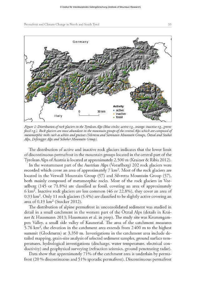
The data provide an important basis for estimating the distribution of permafrost and related hydrological processes (enhanced melting of permafrost ice and its impacts on the runoff) and natural hazards (debris flows). We compiled a rock glacier inven-tory of all mountain groups of western Austria (Tyrol, Vorarlberg). Each rock glacier is documented by an orthophoto and by a datasheet which contains information such as coordinates, altitude, length, width, area, exposition (flow direction), shape, state, hydrology and bedrock in the catchment area. All rock glaciers are listed in an excel-sheet. The inventory is based on the study of high-quality aerial photographs and laser scan images. The rock glacier inventory of the Tyrolean Alps includes 3,145 rock gla-ciers which cover an area of 167.2 km² (Fig. 1). Of these, 517 (16.4%) were classified as active, 915 (29.1%) as inactive, and 1,713 (54.5%) as fossil (Krainer & Ribis 2012).
Tongue-shaped, talus-derived, ice-cemented rock glaciers are the most common type among active and inactive rock glaciers. Glacier-derived rock glaciers containing a massive ice-core are rare. Most rock glaciers occur in the mountain groups of the central Alps in which bedrock is composed mainly of mica schists, paragneiss, or-thogneiss and amphibolites (“Altkristallin”). The majority of active and inactive rock glaciers are exposed towards a northern (NW, N and NE) direction. Active and inac-tive rock glaciers exposed towards S, SE and SW are minimal.
The average ice content of the frozen core drilled at rock glacier Lazaun was 22% at core Lazaun I (near the front), 43% at core Lazaun II, and probably higher in the rooting zone of the rock glacier (Krainer et al. submitted). From geophysical data Hausmann et al. (2007, 2012) calculated ice contents of 45 to 60% for the lower part of Reichenkar rock glacier, 43 to 61% for Ölgrube rock glacier and 45 to 60% for Kaiserberg rock glacier. The total amount of ice in active and inactive rock gla-ciers is estimated to be 0.19 to 0.27 km³ which is small compared to the ice volume contained in the glaciers of the Tyrolean Alps.
© Institut für Interdisziplinäre Gebirgsforschung (Institute of Mountaun Research)
© Institut für Interdisziplinäre Gebirgsforschung (Institute of Mountaun Research)
56 Karl Krainer
occurs in bedrock (7%), till deposits of the Little Ice Age (LIA) (5%), rock glaciers (4%) and talus slope (4%). Sporadic permafrost is most common in bedrock (19%), LIA till deposits (18%), talus slope (11%) and rock glaciers (0.6%). Discontinuous permafrost is abundant in areas (slopes) facing towards a northern direction. Perma-frost also occurs locally in talus slopes facing towards south at elevations of approxi-mately 2,750 m which is indicated by geophysical data and ground surface tempera-tures with the lowest temperatures (–6 °C) on coarse-grained sediment at the front of talus slopes. No permafrost was determined on pre-LIA till deposits.
2 Information from core drilling on an active rock glacier
Important data were obtained from two cores which were drilled at rock glacier La-zaun located at Lazaunkar west of Kurzras in the southern Ötztal Alps (Schnals Val-ley, South Tyrol). A detailed description and discussion of this rock glacier including the core drillings is presented by Krainer et al. (submitted).
Rock glacier Lazaun is a medium-sized active, tongue-shaped rock glacier with a steep front with gradients of 30 to 50°. The rock glacier is 660 m long and up to 200 m wide (Fig. 2). The depression in the rooting zone indicates melting of a mas-sive ice core in this part of the rock glacier. Flow velocity measurements, bottom temperature of snow cover (BTS), water temperature of the springs, steep front and surface morphology demonstrate that the rock glacier is active and contains substan-tial amounts of permafrost ice.
The discharge pattern is typical for active rock glaciers and is characterized by strong diurnal and seasonal variations. During winter (October until May) discharge is extremely low and electrical conductivity high. Highest discharge is recorded du-ring the snowmelt period in June and July, and during rainfall events. Pronounced diurnal variations in discharge are recorded in May and June. From the end of July until October discharge decreases, interrupted by single peaks caused by rainfall events. Warm weather periods in autumn may also cause a slight increase in dischar-ge (increased melting of permafrost ice).
The rock glacier spring is characterized by relatively high electrical conductivity with values of 100 to 275 µS / cm. Water temperature of the rock glacier spring is low (1.3 °C or less) during the entire melt season.
Data from the two cores indicate that the average ice content of the rock glacier is approximately 35 to 40 vol.%. The frozen core of the rock glacier covers an area of approximately 0.1 km², the annual melting rate of the rock glacier ice according to GPS measurements is in the order of 10 cm on average resulting in a total ice volu-me of 10,000 m³ (approx. 9,100 m³ water) which the rock glacier loose by melting each year during the melt season from May until October (six months). This results in an average discharge of 0.6 l / s which is only about 2.3% of the average discharge of the rock glacier (approx. 26 l / s).
© Institut für Interdisziplinäre Gebirgsforschung (Institute of Mountaun Research)

57Permafrost and Climate Change in North and South Tyrol
This indicates that the amount of melt water derived from the melting of perma-frost ice is very low. Even if the melting rate of permafrost ice is 20 cm / year, the amount is less than 5% of the total discharge of the rock glacier. Discharge is mostly derived from snowmelt and summer rainfall with very small amounts of groundwa-ter and melting of permafrost ice.
Core Lazaun I is 40 m long. The active layer (unfrozen debris layer) is 2.8 m thick and underlain by a continuous frozen core (mixture of ice and debris) from 2.8 m to
Figure 2: Location map and map showing the morphology and location of the core drillings at active rock glacier Lazaun. On the right are graphic logs through the cores Lazaun I and Lazaun II showing frozen parts (gray) and C14-ages
© Institut für Interdisziplinäre Gebirgsforschung (Institute of Mountaun Research)

58 Karl Krainer
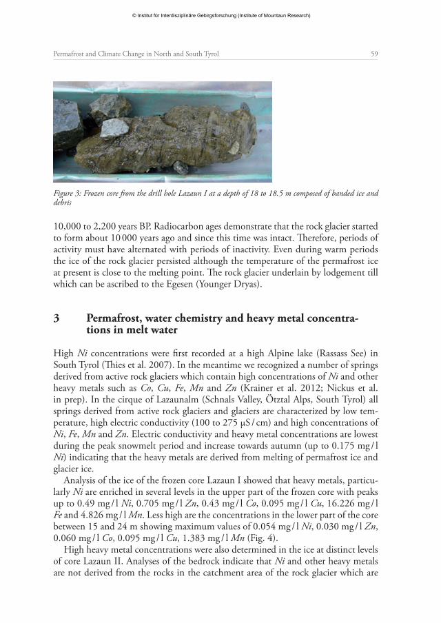
a depth of 13.5 m. From 13.5 to 15.2 m almost ice-free debris is present, and from 15.2 to 25 m again a continuous frozen core was obtained. From 19.5 to 25 m the core contained high amounts of dark colored, banded ice and fine-grained sediment with few clasts with diameters up to several cm floating in the banded ice (Fig. 2 and 3). From 25 to 28 m coarse debris is present, underlain by debris with high amounts of fine-grained sediment down to a depth of 40 m.
Core Lazaun II is 32 m long. This core which was drilled close to the front of the rock glacier contains significantly lower amounts of ice compared to core Lazaun I (Figure 2). The active layer is 4.5 m thick. Ice is present from 4.5 to 5.5 m, from 6.65 to 7.7 m, from 9.1 to 10.5 m and from 15.5 to 18.5 m. From 18.5 to 24.5 m coarse debris with small amounts of fine sediment was obtained, whereas from 24.5 to 32 m coarse debris with high amounts of fine sediment occurred. The average ice content of the frozen core is 22%.
The ice content of the frozen core varies considerably from almost zero up to 98%. The average ice content of core Lazaun I between 2.8 and 25 m is 43%. The average ice content is higher between 2.8 and 14 m (48%) and between 19.5 and 25 m (51%). We assume that in the upper part of the rock glacier, particularly in the rooting zone the ice content is somewhat higher. Near the front (core Lazaun II) the ice content is 22%.
The average ice content of Lazaun rock glacier is approximately 35 to 40%. The total area of the rock glacier is 0.12 km², the area of the frozen core is estimated to be 0.1 km² resulting in a total ice volume of 740,000 to 850 ,000 m³ (average thickness of the frozen core 21 m).
The melting rate of ice of Lazaun rock glacier is in the order of 10 cm / a resulting in a total loss of ice by melting of 10,000 m³ / year. Thus at present melting of perma-frost ice causes a loss of about 1.2 to 1.3% of the total ice volume each year.
At the base of core Lazaun I banded ice with low amounts of debris is present. The rock glacier is composed of two frozen bodies, separated by an unfrozen debris lay-er which is about 2 m thick. At present both frozen bodies are active. Inclinometer measurements indicate that deformation occurs within a shear horizon at a depth of 20 to 24 m which is at the base of the lower frozen core, and to a minor extent also at a shear horizon at 14 m which is at the base of the upper frozen core.
Borehole temperatures in the frozen core are near the melting point never decre-asing below –0.9 °C, indicating the presence of warm permafrost ice. Although no ice was determined below a depth of 24 m, borehole temperatures in the debris layer and lodgement till are slightly below zero down to a depth of 35 m.
Radiocarbon ages from core Lazaun I range from 2,235 cal. BP at a depth of 2.82 m (near the surface of the frozen core of the rock glacier) to 8,959 ± 311 cal. BP at a depth of 23.51 m, approximately 1.5 m above the base of the frozen core of the rock glacier (Fig. 2). One sample from core Lazaun II from a depth of 9.5 m yielded an age of 5,145 ± 30 cal. BP. Radiocarbon ages indicate that the ice at the base of the rock glacier is approximately 10,000 years old and that the frozen core of the rock glacier represents an undisturbed stratigraphic succession covering a time span from
© Institut für Interdisziplinäre Gebirgsforschung (Institute of Mountaun Research)
59Permafrost and Climate Change in North and South Tyrol
10,000 to 2,200 years BP. Radiocarbon ages demonstrate that the rock glacier started to form about 10 000 years ago and since this time was intact. Therefore, periods of activity must have alternated with periods of inactivity. Even during warm periods the ice of the rock glacier persisted although the temperature of the permafrost ice at present is close to the melting point. The rock glacier underlain by lodgement till which can be ascribed to the Egesen (Younger Dryas).
3 Permafrost, water chemistry and heavy metal concentra-tions in melt water
High Ni concentrations were first recorded at a high Alpine lake (Rassass See) in South Tyrol (Thies et al. 2007). In the meantime we recognized a number of springs derived from active rock glaciers which contain high concentrations of Ni and other heavy metals such as Co, Cu, Fe, Mn and Zn (Krainer et al. 2012; Nickus et al. in prep). In the cirque of Lazaunalm (Schnals Valley, Ötztal Alps, South Tyrol) all springs derived from active rock glaciers and glaciers are characterized by low tem-perature, high electric conductivity (100 to 275 µS / cm) and high concentrations of Ni, Fe, Mn and Zn. Electric conductivity and heavy metal concentrations are lowest during the peak snowmelt period and increase towards autumn (up to 0.175 mg / l Ni) indicating that the heavy metals are derived from melting of permafrost ice and glacier ice.
Analysis of the ice of the frozen core Lazaun I showed that heavy metals, particu-larly Ni are enriched in several levels in the upper part of the frozen core with peaks up to 0.49 mg / l Ni, 0.705 mg / l Zn, 0.43 mg / l Co, 0.095 mg / l Cu, 16.226 mg / l Fe and 4.826 mg / l Mn. Less high are the concentrations in the lower part of the core between 15 and 24 m showing maximum values of 0.054 mg / l Ni, 0.030 mg / l Zn, 0.060 mg / l Co, 0.095 mg / l Cu, 1.383 mg / l Mn (Fig. 4).
High heavy metal concentrations were also determined in the ice at distinct levels of core Lazaun II. Analyses of the bedrock indicate that Ni and other heavy metals are not derived from the rocks in the catchment area of the rock glacier which are
Figure 3: Frozen core from the drill hole Lazaun I at a depth of 18 to 18.5 m composed of banded ice and debris
© Institut für Interdisziplinäre Gebirgsforschung (Institute of Mountaun Research)

60 Karl Krainer
composed of mica schist and paragneiss of the Ötztal-Stubai-Metamorphic Com-plex. Analyses of the permafrost ice also demonstrate that the high Ni concentrations in the spring water are derived from distinct horizons of the permafrost ice.
High Ni concentrations were measured in a 2 m thick ice core which was drilled on active rock glacier Rossbänk (Ulten Valley, South Tyrol). High Ni concentrations are also recorded in rock glacier springs at Inneres Hochebenkar near Obergurgl, in the Windach Valley south of Sölden, at Krummgampental and Wurmetal (Kauner-tal), all located in the Ötztal Alps (Tyrol, Austria) and also in a small creek derived from a glacier south of the Franz Senn Hütte (Stubai Alps) (Fig. 5). The source of the Ni is unknown and we assume that Ni is derived from the atmosphere.
Water released from Hochebenkar rock glacier has been studied for its chemical composition since summer 2007 (Nickus et al. in press). At one of the rock glacier springs, which is located on the eastern side at an elevation of 2,560 m the electrical conductivity is high. The values range between 100 and 200 µS / cm during the ma-jor snow melt period in June and increase with decreasing runoff. In fall, solute con-centration reaches its maximum, and electrical conductivity is around 500 µS / cm. Heavy summer precipitation events generally cause a dilution of the highly concen-trated water of the spring, and runoff peaks often coincide with low electrical con-ductivity values. Sulfate, calcium and magnesium dominate the ion content and comprise more than 90% of the ion balance. Heavy metals are absent.
The seasonal variation of the solute concentration reflects the varying contribu-tions of snowmelt, precipitation events, groundwater and melting of permafrost ice to the runoff. The authors assume that the high amount of solutes in late summer and fall is released from the permafrost ice of the rock glacier. Melt water from per-mafrost ice seems to be particularly rich in sulfate and the relative contribution of sulfate to the total ion content of the rock glacier runoff generally rises from late spring to fall (Nickus et al. in prep.).
Figure 4: The distribution of Ni in the frozen core Lazaun I. High Ni concentrations were recorded in the upper part with peaks showing extreme values at depths of 4.1 m, 9.8 m and 12.2 m
© Institut für Interdisziplinäre Gebirgsforschung (Institute of Mountaun Research)

61Permafrost and Climate Change in North and South Tyrol
4 Permafrost and discharge
The influence of climate change on the discharge of catchment areas underlain by permafrost is one of the main goals. Hydrological studies on active rock glaciers showed that discharge is mainly controlled by the local weather conditions, the ther-mal properties of the unfrozen debris layer (active layer), and the physical mecha-nisms that control the flow of melt water through the rock glacier (Krainer & Most-ler 2002; Krainer et al. 2007).
In general, discharge of active rock glaciers is characterized by strong seasonal and diurnal variations (Fig. 6). Most of the water released at rock glacier springs is de-rived from snowmelt and rainfall events, and only small amounts are derived from melting of permafrost ice and groundwater. Water derived from snowmelt and rain-fall events during summer is quickly released producing sharp discharge peaks. Fair weather periods with intense melting of snow cause pronounced diurnal variations in discharge during the snowmelt period (May to July). Water temperature of springs of active rock glaciers remains constantly around 1 °C during the entire melt peri-od. Values of delta18O and electrical conductivity (EC) of the melt water are lowest during high discharge, particular during the main snowmelt period. Delta18O and EC progressively increase until late July to early August when the snow of the pre-ceding winter is completely melted. Highest values of EC are recorded in autumn. This increase in delta18O and EC is caused by a progressive decrease in the ratio of snowmelt versus ice melt plus groundwater. Meltwater derived from summer rain-
Figure 5: Map showing the location of rock glacier springs and glacier creeks containing high concentrations of Ni (UL Ulten Valley, Ni in the ice of the frozen core; LZ Lazaun, Ni in rock glacier springs and glacier creek; KG Krummgampen, Ni in rock glacier springs; WU Wurmetal, Ni in springs derived from permafrost; WI Windach, Ni in several rock glacier springs; FS Franz Senn Hütte, Ni in a glacier creek)
© Institut für Interdisziplinäre Gebirgsforschung (Institute of Mountaun Research)

62 Karl Krainer
fall events is quickly released within a few hours causing sharp peaks in discharge, a less pronounced peak in delta18O and a pronounced decrease in electric conductivity (Krainer & Mostler 2002; Krainer et al. 2007).
Gobal Positioning System (GPS) measurements and hydrological data indicate the annual melting rate of permafrost ice of rock glaciers is small and that the amount of water released by the melting of permafrost ice is less than 5% of the total discharge.
To understand the subsurface flow paths in a permafrost-influenced catchment and to assess the effect of increased melting of permafrost on the hydrologic regime, detailed hydrological studies were carried out at Krummgampen the distribution of permafrost was studied in detail (see above). A distributed hydrological model was applied to simulate the discharge in the catchment of Krummgampen under the pre-sent conditions and in a future scenario without permafrost. The simulations indica-te that the complete melting of permafrost ice in the catchment of Krummgampen will increase the storage capacity of the sediments which will reduce the flood peaks up to 20% and increase runoff during recession of about 15% (details in Krainer & Hausmann 2013; Rogger et al. in prep.).
Figure 6: Discharge pattern of an active rock glacier (Kaiserberg, western Ötztal Alps) for the period April to October 2013. The melt season started in mid-April, discharge was relatively low during May and the beginning of June due to cool weather, increased strongly in mid-June caused by extremely warm weather, decreased at the end of June due to cool weather, was high at the beginning of July and then continuously decreased towards October just interrupted by single peaks caused by rainfall events (left scale: water height in mm, right scale: water temperature in °C)
© Institut für Interdisziplinäre Gebirgsforschung (Institute of Mountaun Research)

63Permafrost and Climate Change in North and South Tyrol
5 Conclusions
The high number of active and inactive rock glaciers in the western part of the Aus-trian Alps documents that alpine permafrost is widespread, particularly in mountain groups in the central part of the Austrian Alps which are composed of metamor-phic rocks (schists and gneisses). Detailed permafrost mapping at Krummgampen shows that permafrost is not restricted to active and inactive rock glaciers but is also common in unconsolidated sediments such as talus and till deposits, particularly on north-facing slopes above an elevation of 2,500 m.
Radiocarbon dating of ice from active rock glacier Lazaun shows that permafrost ice of rock glaciers may be up to 10,000 years old. Although borehole measurements at rock glacier Lazaun demonstrate that the temperature of the ice is close to the mel-ting point, the ice persisted even warmer periods during the last 10,000 years.
Hydrological studies show that the amount of melt water released from rock gla-ciers due to increased melting caused by global warming is small compared to the total discharge. Most of the melt water is derived from snowmelt and precipitation and less than 5% is derived from melting of permafrost ice.
Chemical analyses of melt water show that some rock glacier springs are highly contaminated by Ni and other heavy metals. Analyses of the ice from the core drilled at rock glacier Lazaun demonstrate that Ni is concentrated in the permafrost ice and that individual horizons in the permafrost ice contain extremely high amounts of Ni and other heavy metals. We assume that not only at rock glacier Lazaun but also at other locations Ni and other heavy metals in the melt water are derived from increa-sed melting of permafrost ice. The source of Ni is unknown, chemical analyses indi-cate that Ni is not derived from the bedrock.
Increased melting of permafrost ice in rock glaciers and unconsolidated sediments such as talus and till deposits will reduce the volume of permafrost ice and increase the pore space and thus the storage capacity for water in the sediments. Hydrologi-cal simulations at Krummgampen indicate that increased melting of permafrost will result in a decrease in flood peak discharge of up to 20% and an increase of runoff during recession periods of up to 15% due to an increase in the storage capacity of the sediments in the catchment.
6 Acknowledgements
The present paper is a brief summary of results obtained from scientific projects fun-ded by the Austrian Academy of Sciences (International Strategy for Desaster Re-duction, ISDR), FWF (Austrian Science Fund) and PermaNET. The author wishes to thank all persons involved in these projects, particularly G. Blöschl, E. Brückl, H. Hausmann, U. Nickus, M. Rogger, R. Tessadri and H. Thies.
© Institut für Interdisziplinäre Gebirgsforschung (Institute of Mountaun Research)
64 Karl Krainer
7 References
Ackert, R.P. 1998: A rock glacier / debris-covered glacier system at Galena Creek, Absaroka Mountains, Wyoming. Geografiska Annaler 80, 3-4: 267–276.
Auer, I., R. Böhm, A. Jurkovic, W. Lipa, A. Orlik, R. Potzmann, W. Schöner, M. Ungersböck, C. Mat-ulla, K. Briffa, P. Jones, D. Efthymiadis, M. Brunetti, T. Nanni, M. Maugeri, L. Mercalli, O. Mestre, J.-M. Moisselin, M. Begert, G. Müller-Westermeier, V. Kveton, O. Bochnicek, P. Stastny, M. Lapin, S. Szalai, T. Szentimrey, T. Cegnar, M. Dolinar, M. Gajic-Capka, K. Zaninovic, Z. Majstorovic & E. Nieplova 2007: HISTALP-historical instrumental climatological surface time series of the Greater Alpine Region. International Journal of Climatology 27: 17–46.
Barsch, D. 1996: Rockglaciers. Indicators for the Present and Former Geoecology in High Mountain Envi-ronments. Berlin.
Berger, J., K. Krainer & W. Mostler 2004: Dynamics of an active rock glacier (Ötztal Alps, Austria). Quaternary Research 62: 233–242.
Boeckli, L., A. Brenning, S. Gruber & J. Noetzli 2012: A statistical approach to modelling perma-frost distribution in the European Alps or similar mountain ranges. The Cryosphere 6: 125–140. doi:10.5194/tc-6-125-2012.
Brückl, E., H. Hausmann, K. Krainer & W. Mostler 2005: Internal structure of Reichenkar rock gla-cier. Geophysical Research Abstracts 7, SRef-ID: 1607-7962/gra/EGU05-A-02358.
Chesi, G., K. Krainer, W. Mostler & T. Weinold 1999: Bewegungsmessungen am aktiven Block-gletscher Inneres Reichenkar mit der GPS-Methode. In: 10. Internationale Geodätische Woche Ober-gurgl 1999: 223–227.
Chesi, G., S. Geissler, K. Krainer, W. Mostler & T. Weinold 2003: 5 Jahre Bewegungsmessungen am aktiven Blockgletscher Inneres Reichenkar (westliche Stubaier Alpen) mit der GPS-Methode. In: 12. Internationale Geodätische Woche Obergurgl 2003: 201–205.
Clark, D.H., E.J. Steig, N. Potter & A.R. Gillespie 1998: Genetic variability of rock glaciers. Geografis-ka Annaler 80, 3-4: 175–182.
Clow, D.W., L. Schrott, R. Webb, D.H. Campbell, A. Torizzo & M. Domblaser 2003: Ground Wa-ter Occurrence and Contributions to Streamflow in an Alpine Catchment, Colorado Front Range. Ground Water – Watershed 41, 7: 937–950. doi:10.1111/j.1745-6584.2003.tb02436.x.
Davis, N. 2001: Permafrost: a guide to frozen ground in transition. Fairbanks.Etzelmüller, B. & J.O. Hagen 2005: Glacier – permafrost interaction in Arctic and alpine mountain
environments with examples from southern Norway and Svalbard. In: Harris, C. & J.B. Murton (eds.): Cryospheric Systems: Glaciers and Permafrost. Geological Society Special Publication 242. Lon-don: 11–27.
French, H.M. 1996: The Periglacial Ennvironment. Essex.Gärtner-Roer, I. 2010: Permafrost. In: Voigt, T., H.-M. Füssel, I. Gärtner-Roer, C. Huggel, C. Marty &
M. Zemp (eds.): Impacts of climate change on snow, ice, and permafrost in Europe: Observed trends, fu-ture projections, and socioeconomic relevance. ETC/ACC Technical Paper 2010/13. Bilthoven: 66–76.
Gerhold, N. 1967: Zur Glazialgeologie der westlichen Ötztaler Alpen. Veröffentlichungen des Museum Ferdinandeum 47: 5–50.
Gerhold, N. 1969: Zur Glazialgeologie der westlichen Ötztaler Alpen unter besonderer Berücksichti-gung des Blockgletscherproblems. Veröffentlichungen des Museum Ferdinandeum 49, 45–78.
Haeberli, W. 1985: Creep of mountain permafrost: Internal structure and flow of alpine rock glaciers. Mitteilungen der Versuchsanstalt für Wasserbau, Hydrologie und Glaziologie ETH Zürich 77: 1–142.
Haeberli, W. 1990: Scientific, environmental and climatic significance of rock glaciers. Memorie della Società Geologica Italiana 45: 823–831.
Haeberli, W. 1995: Permafrost und Blockgletscher in den Alpen. Vierteljahrsschrift der Naturforschenden Gesellschaft in Zürich 140, 3: 113–121.
© Institut für Interdisziplinäre Gebirgsforschung (Institute of Mountaun Research)

65Permafrost and Climate Change in North and South Tyrol
Haeberli, W. 2005: Investigating glacier – permafrost relationships in high-mountain areas: historical background, selected examples and research needs. In: Harris, C. & J.B. Murton (eds.): Cryospheric Systems: Glaciers and Permafrost. Geological Society Special Publication 242. London: 29–37.
Haeberli, W., B. Hallet, L. Arenson, R. Elconin, O. Humlum, A. Kääb, V. Kaufmann, B. Ladanyi, N. Matsuoka, S. Springman & D. Vonder Mühll 2006: Permafrost Creep and Rock Glacier Dynamics. Permafrost and Periglacial Processes 17: 189–216.
Hausmann H., K. Krainer & E. Brückl (submitted). Mapping and modelling of mountain permafrost us-ing seismic refraction and ground surface temperatures, Krummgampen Valley, Ötztal Alps, Austria.
Hausmann, H., K. Krainer, E. Brückl & W. Mostler 2006a: Dynamics of Alpine rock glaciers in the context of global warming. Geophysical Research Abstracts 8, SRef-ID: 1607-7962/gra/EGU06-A-04718.
Hausmann, H., K. Krainer, E. Brückl & W. Mostler 2006b: Creep of three alpine rock glaciers – ob-servation and modelling (Ötztal and Stubai Alps, Austria). In: Abtracts of the HMRSC-IX. 9th Inter-national Symposium on High Mountain Remote Sensing Cartography, Graz, Austria, 14–22 September 2006: 60.
Hausmann, H., K. Krainer, E. Brückl & W. Mostler 2007: Internal structure, composition and dynam-ics of Reichenkar rock glacier (western Stubai Alps, Austria). Permafrost and Periglacial Processes 18, 351–367. doi:10.1002/ppp.60.
Hausmann, H., K. Krainer, E. Brückl & C. Ullrich 2012: Internal structure, ice content and dynamics of Ölgrube and Kaiserberg rock glaciers (Ötztal Alps, Austria) determined from geophysical surveys. Austrian Journal of Earth Sciences 105, 2: 12–31.
Humlum, O. 1996: Origin of Rock Glaciers: Observations from Mellemfjord, Disko Island, Central West Greenland. Permafrost and Periglacial Processes 7: 361–380.
Johnson, P.G. 1981: The structure of a talus-derived rock glacier deduced from its hydrology. Canadian Journal of Earth Sciences 18: 1422–1430.
Kaufmann, V. 1996a: Der Dösener Blockgletscher – Studienkarten und Bewegungsmessungen. In: Bei-träge zur Permafrostforschung in Österreich, Arbeiten aus dem Institut für Geographie, Karl-Franzens-Universität Graz 33: 141–162.
Kaufmann, V. 1996b: Geomorphometric monitoring of active rock glaciers in the Austrian Alps. In: Proceedings of the 4th
international symposium on High Mountain Remote Sensing Cartography. Karl-
stad, Kiruna, Tromso, 19–29 August 1996: 97–113. Kaufmann, V. 2012: The evolution of rock glacier monitoring using terrestrial photogrammetry: the ex-
ample of Äußeres Hochebenkar rock glacier (Austria). Austrian Journal of Earth Sciences 105, 2: 63–77.Kaufmann, V. & R. Ladstädter 2002: Spatio-temporal analysis of the dynamic behavioud of the
Hochebenkar rock glaciers (Oetztal Alps, Austria) by means of digital photogrammetric methods. Grazer Schriften der Geographie und Raumforschung 37: 119–140.
Kaufmann, V. & R. Ladstädter 2003: Quantitative analysis of rock glacier creep by means of digital photogrammetry using multi-temporal aerial photographs: two case studies in the Austrian Alps. In: Phillips M., S.M. Springman & L.U. Arenson (eds.): Permafrost: Proceedings of the 8th International Conference on Permafrost, Zurich, Switzerland, 21-25 July 2003: 525–530.
Kellerer-Pirklbauer, A., G.K. Lieb & H. Kleinferchner 2012: A new rock glacier inventory of the East-ern European Alps. Austrian Journal of Earth Sciences 105, 2: 78–93.
Kienast, G. & V. Kaufmann 2004: Geodetic measurements on glaciers and rock glaciers in the Hohe Tauern National Park (Austria). In: Proceedings of the 4th ICA Mountain Cartography Workshop. Vall de Núria, Catalonia, Spain, 30 September–2 October 2004: 77–88.
Krainer, K. & H. Hausmann 2013: Permafrost in Austria: Impact of climate change on alpine permafrost and related hydrological effects. Austrian Academy of Sciences, ISDR Final Report 2007–2011. doi: 10.1553/ISDR-22s1.
© Institut für Interdisziplinäre Gebirgsforschung (Institute of Mountaun Research)

66 Karl Krainer
Krainer, K. & W. Mostler 2000a: Reichenkar Rock Glacier: a Glacier Derived Debris-Ice System in the Western Stubai Alps, Austria. Permafrost and Periglacial Processes 11: 267–275.
Krainer, K. & W. Mostler 2000b: Aktive Blockgletscher als Transportsysteme für Schuttmassen im Hochgebirge: Der Reichenkar Blockgletscher in den westlichen Stubaier Alpen. Geoforum Umhaus-en 1: 28–43.
Krainer, K. & W. Mostler 2001: Der aktive Blockgletscher im Hinteren Langtal Kar, Gößnitztal (Schobergruppe, Nationalpark Hohe Tauern, Österreich). Wissenschaftliche Mitteilungen aus dem Nationalpark Hohe Tauern 6: 139–168.
Krainer, K. & W. Mostler 2002: Hydrology of Active Rock Glaciers: Examples from the Austrian Alps. Arctic, Antarctic, and Alpine Research 34: 142–149.
Krainer, K. & W. Mostler 2004: Aufbau und Entstehung des aktiven Blockgletschers im Sulzkar, west-liche Stubaier Alpen (Tirol). Geo.Alp 1: 37–55.
Krainer, K. & W. Mostler 2006: Flow Velocities of Active Rock Glaciers in the Austrian Alps. Geo-grafiska Annaler 88A: 267–280.
Krainer, K. & M. Ribis 2012: A Rock Glacier Inventory of the Tyrolean Alps (Austria). Austrian Journal of Earth Sciences 105, 2: 32–47.
Krainer, K., W. Mostler & N. Span 2002: A glacier-derived, ice-cored rock glacier in the western Stubai Alps (Austria): evidence from ice exposures and ground penetrating radar investigation. Zeitschrift für Gletscherkunde und Glazialgeologie 38: 21–34.
Krainer, K., W. Mostler & C. Spötl 2007: Discharge from active rock glaciers, Austrian Alps: a stable isotope approach. Austrian Journal of Earth Sciences 100: 102–112.
Krainer, K., A. Kellerer-Pirklbauer, V. Kaufmann, G.K. Lieb, L. Schrott & H. Hausmann 2012: Per-mafrost Research in Austria: History and recent advances. Austrian Journal of Earth Sciences 105, 2: 2–11.
Krainer, K., K. Lang, V. Mair, U. Nickus, R. Tessadri, D. Tonodandel & H. Thies 2012: Core drill-ing on active rock glacier Lazaun (southern Ötztal Alps, South Tyrol). In: Pangeo Austria, Salzburg, 15–20 September 2012 – Abstracts: 83–84.
Krainer, K., D. Bressan, B. Dietre, J.N. Haas, I. Hajdas, U. Nickus, D. Reidl, H. Thies & D. Tonidan-del (submitted): A 10 300-year old ice core from active rock glacier Lazaun, southern Ötztal Alps (South Tyrol, northern Italy).
Ladstädter, R. & V. Kaufmann 2005: Studying the movement of the Outer Hochebenkar rock glacier: Aerial vs. ground-based photogrammetric methods. In: 2nd
European Conference on Permafrost, Pots-
dam, Germany, 12–16 June 2005, Programme and Abstracts. Terra Nostra, 2005 / 2: 97. Lieb, G.K. 1996: Permafrost und Blockgletscher in den östlichen österreichischen Alpen. In: Institut
für Geographie der Karl-Franzens-Universität Graz (Hrsg.): Beiträge zur Permafrostforschung in Ös-terreich. Grazer Schriften der Geographie und Raumforschung 33: 9–125.
Lieb, G.K. 1986: Permafrost und Blockgletscher der östlichen Schobergruppe (Hohe Tauern, Kärn-ten). In: Institut für Geographie der Karl-Franzens-Universität Graz (Hrsg.): Festschrift für Wilhelm Leitner zum 60. Geburtstag. Grazer Schriften der Geographie und Raumforschung 27: 123–132.
Lieb, G.K. 1987: Zur spätglazialen Gletscher- und Blockgletschergeschichte im Vergleich zwischen den Hohen und Niederen Tauern. Mitteilungen der Österreichischen Geographischen Gesellschaft 129: 5–27.
Lieb, G.K. 1991: Die horizontale und vertikale Verteilung der Blockgletscher in den Hohen Tauern (Österreich). Zeitschrift für Geomorphologie N.F. 35, 3: 345–365.
Lieb, G.K. & H. Slupetzky 1993: Der Tauernfleck-Blockgletscher im Hollersbachtal (Venedigergruppe, Salzburg, Österreich). Wissenschaftliche Mitteilungen aus dem Nationalpark Hohe Tauern 1: 138–146.
Lieb, G.K., A. Kellerer-Pirklbauer & H. Kleinferchner 2010: Rock glacier inventory of Central and East-ern Austria elaborated within the PermaNET project. Digital Media (Inventory Version 2: January 2012). Institute of Geography and Regional Science, University of Graz.
© Institut für Interdisziplinäre Gebirgsforschung (Institute of Mountaun Research)

67Permafrost and Climate Change in North and South Tyrol
Liu, F., M.W. Williams & N. Caine 2004: Source waters and flow paths in an alpine catchment, Colorado Front Range, United States. Water Resources Research 40, 9. W09401. doi:10.1029/2004WR003076.
Mair, V., A. Zischg, K. Lang, D. Tonidandel, K. Krainer, A. Kellerer-Pirklbauer, P. Deline, P. Schoe-neich, E. Cremonese, P. Pogliotti, S. Gruber & L. Böckli 2011: PermaNET permafrost. Long-term Monitoring Network. Synthesis Report. INTERPRAEVENT 1, 3. Klagenfurt.
Martin, H.E. & W.B. Whalley 1987: Rock glaciers, part 1: rock glacier morphology: classification and distribution. Progress in Physical Geography 11: 260–282.
McClymont, A., J.W. Roy, M. Hayashi, L.R. Bentley, H. Maurer & G. Langston 2011: Investigating groundwater flow paths within proglacial moraine using multiple geophysical methods. Journal of Hydrology 399, 1-2: 57–69. doi:10.1016/j.jhydrol.2010.12.036.
Nickus, U., J. Abermann, A. Fischer, K. Krainer, H. Schneider, N. Span & H. Thies (in press): Rock Glacier Äußeres Hochebenkar 1 (Austria) Recent results of a monitoring network. Zeitschrift für Gletscherkunde und Glazialgeologie.
Potter, N. 1972: Ice-Cored Rock Glacier, Galena Creek, Northern Absaroka Mountains, Wyoming. Geological Society of America Bulletin 83: 3025–3058.
Potter, N., E.J. Steig, D.H. Clark, M.A. Speece, G.M. Clark & A.B. Updike 1998: Galena Creek rock glacier revisited – new observations on an old controversy. Geografiska Annaler 80, 3-4: 251–265.
Rogger, M., G.B. Chirico, H. Hausmann, K. Krainer, E. Brückl & G. Blöschl (submitted): Impact of mountain permafrost on flow path and runoff response in a high alpine catchment.
Schmöller, R. & R.K. Fruhwirth 1996: Komplexgeophysikalische Untersuchungen auf dem Dösener Blockgletscher (Hohe Tauern, Österreich). In: Institut für Geographie und Raumforschung der Karl-Franzens-Universität Graz (ed.): Beiträge zur Permafrostforschung in Österreich. Grazer Schriften der Geographie und Raumforschung 33: 165–190.
Shroder, J.F., M.P. Bishop, L. Copland & V.F. Sloan 2000: Debris-covered glaciers and rock glaciers in the Nanga Parbat Himalaya, Pakistan. Geografiska Annaler 82, 1: 17–31.
Solomon, S., D. Qin, M. Manning, Z. Chen, M. Marquis, K.B. Averyt, M. Tignor & H.L. Miller (eds.): Climate Change 2007 – The Physical Science Basis. Contribution of Working Group I to the Fourth Assessment Report of the Intergovernmental Panel on Climate Change. Cambridge, New York.
Stocker, K. 2012: Blockgletscher in Vorarlberg und in der Verwallgruppe. In: Vorarlberger Landesmu-seumverein (Hrsg.): museums verein jahrbuch 2012: 124–139.
Thies, H., U. Nickus, V. Mair, R. Tessadri, D. Tait, B. Thaler & R. Psenner 2007: Unexpected response of high alpine lake waters to climate warming. Environmental Science Technology 41: 7424–7429.
Vitek, J.D. & J.R. Giardino 1987: Rock glaciers: a review of the knowledge base. In: Giardino, J.R., J.F. Shroder & J.D. Vitek (eds.): Rock Glaciers. London: 1–26.
Washburn, A.L. 1979: Geocryology: a survey of periglacial processes and environments. London.Wahrhaftig, C. & A. Cox 1959: Rock glaciers in the Alaska Range. Geological Society of America Bul-
letin 70: 383–436.Whalley, W.B. & H.E. Martin 1992: Rock glaciers: II models and mechanisms. Progress in Physical Ge-
ography 16, 2: 127–186.Whalley, W.B., C. Palmer, S. Hamilton & J. Gordon 1994: Ice exposures in rock glaciers. Journal of
Glaciology 40, 135: 427–429.Whalley, W.B. & C.F. Palmer 1998: A glacial interpretation for the origin and formation of the Marinet
Rock Glacier, Alpes Maritimes, France. Geografiska Annaler 80, 3-4: 221–236.White, S.E. 1971: Rock glacier studies in the Colorado Front Range, 1961 to 1968. Arctic and Alpine
Research 3, 1: 43–64.Yershov, E.D. 1998: General Geocryology. Studies in Polar Research. Cambridge.
© Institut für Interdisziplinäre Gebirgsforschung (Institute of Mountaun Research)