Hazards related to permafrost and to permafrost · PDF fileHazards related to permafrost and...
43
WP 6 – Action 6.2 – State of the art report Hazards related to permafrost and to permafrost degradation Citation reference of the report Schoeneich P., Dall’Amico M., Deline P., Zischg A., eds (2011). Hazards related to permafrost and to permafrost degradation. PermaNET project, state-of-the-art report 6.2. On-line publication ISBN 978- 2-903095-59-8. Downladable on: www.permanet-alpinespace.eu Editors Philippe Schoeneich, Institut de Géographie Alpine, Université de Grenoble, France Matteo Dall’Amico, Geological service, Autonomous Province of Trento, Italy Philip Deline, EDYTEM, Université de Savoie, France Andreas Zischg, Abenis Alpinexpert GmbH/srl, Bozen/Bolzano, Italy Project reference European Territorial Cooperation, Alpine Space Programme Project PermaNET – Long term monitoring network for permafrost, 2008-2011.
Transcript of Hazards related to permafrost and to permafrost · PDF fileHazards related to permafrost and...
WP 6 – Action 6.2 – State of the art report
Hazards related to permafrost
and to permafrost degradation
Citation reference of the report
Schoeneich P., Dall’Amico M., Deline P., Zischg A., eds (2011). Hazards related to permafrost and to
permafrost degradation. PermaNET project, state-of-the-art report 6.2. On-line publication ISBN 978-
2-903095-59-8.
Downladable on: www.permanet-alpinespace.eu
Editors
Philippe Schoeneich, Institut de Géographie Alpine, Université de Grenoble, France
Matteo Dall’Amico, Geological service, Autonomous Province of Trento, Italy
Philip Deline, EDYTEM, Université de Savoie, France
Andreas Zischg, Abenis Alpinexpert GmbH/srl, Bozen/Bolzano, Italy
Project reference
European Territorial Cooperation, Alpine Space Programme
Project PermaNET – Long term monitoring network for permafrost, 2008-2011.

PermaNET – Hazards related to permafrost
ADRA - Association pour la diffusion de la recherche alpine
14 bis av. Marie-Reynoard
F-38100 Grenoble
ISBN 978-2-903095-59-8
107
4.
Local ground movements
and effects on infrastructures
Citation reference of the chapter
Dall’Amico M., Carton A., Cremonese E., Curtaz M., Morra di Cella U., Paro L., Phillips M., Pogliotti P.,
Schoeneich P., Seppi R., Zampedri, G., Zumiani M. (2011). Chapter 4: Local ground movements and
effects on infrastructures. In Schoeneich P. et al. (eds): Hazards related to permafrost and to
permafrost degradation. PermaNET project, state-of-the-art report 6.2. On-line publication ISBN 978-
2-903095-59-8, p. 107-147.
Authors
Coordination : GST-PAT – Matteo Dall’Amico
Involved PPs and contributors :
- GST-PAT – Giorgio Zampedri, Roberto Seppi, Matteo Zumiani, Alberto Carton
- IGA-PACTE – Philippe Schoeneich
- RAVA and Fondazione Montagna Sicura (Valle d’Aosta – Italy) : Umberto Morra di Cella,
Edoardo Cremonese, Paolo Pogliotti, Michèle Curtaz e Stefanie …
- ARPA Piemonte : Luca Paro
- WSL-EISLF Davos : Marcia Phillips
Content
1. Introduction
2. Typology and involved processes
Damages to building
Damages to cable cars
Damages to hazard protections
Planation induced « thermokarst »
3. Case studies
4. References
PermaNET – Hazards related to permafrost
108
Summary fo decision makers
Local ground movements may be defined as phenomena of instability that affect slopes or flat
ground in a surface of hundreds to thousands of square meters. Local ground movements are a
common feature in permafrost areas, and include:
• Horizontal downslope movements, due to the creep of permafrost bodies.
• Vertical settling movements, due to the melting of ice bodies and/or interstitial ice.
These movements may cause damages to buildings and infrastructures or more rarely represent
a hazard for persons:
• Damages to buildings are mainly due to differential settling of the ground. Some
mountain huts are endangered by the collapse of the rock foundations.
• Cableways are the most common and sensible infrastructures in alpine permafrost areas.
Movements of pylons and of start and end stations lead to problems of cable alignement.
It induces increased maintenance costs, and reduces the lifetime of the investment.
• The stability of hazard protection infrastructures can be changelled by premafrost
degradation.
• Thermokarst phenomena due to the removal or compaction of the surface layer can
cause substantial damage to planation works like ski tracks or roads.
In many cases, it must be emphasized that the infrastructure may induce itself the degradation of
the undelying permafrost, through heat conduction by the infrastructure, or through the
modification of the insulation capacity of the ground.
An adapted conception of the infrastructure can, in many cases, avoid both the influence on the
permafrost state and damages due to movements.
When planning an infrastructure in a high mountain environement (e.g. above 2400 m), the
possible presence of permafrost should always be investigated prior to the conception. The
permafrost distribution map can give a first indication. Geophysical methods permit to detect the
possible occurrence of frozen ground. But only a drilling can give reliable information on the
presence and thickness of ground ice. Monitoring of temperature and movements during at least
one year will give more informations on potential surface movements.
If permafrost is present, an adapted design should be developped, such as:
• A thermal insulation in order to avoid heat transmission from buildings into the frozen
ground.
• Adapted foundations in order to accommodate movements.
Arctic countries have a long experience in adapted design of infrastructures. Guidelines for
building on mountain permafrost were edited by Swiss authorities.
Local ground movements and effects on infrastructures
109
1. Introduction
Usually local ground movements are monitored and studied in low- and middle-range mountain
environments, where the interaction and the hazard to human settlements are more elevated. In
high mountain range these movements are rarely investigated, because of (1) logistical difficulties,
(2) scarce interaction with infrastructures and villages and (3) the low level of knowledge on the
phenomena related with the cryosphere.
Recent increase in global temperature and the ever more presence of human tourism and
infrastructures in high mountains, has pointed out the importance of a more detailed study of these
phenomena.
The presence of permafrost in high alpine environments increases the difficulty in dealing with the
analysis of local ground movements. In fact, the current approach on analyzing slope deformations
and landslides has often been hydro-mechanical, i.e. the tensions and deformations have normally
been related to water pressure and mechanical stress-strain relationship. If this approach may be
well suited for low range mountain elevations, this might be insufficient in high elevations, where the
thermal effect could play an important role on the stability (Harris). For this reason it is important to
start the monitoring of these phenomena in high alpine sites, and include to the current monitoring
techniques the measurements of temperature. This will ultimately allow correlating the
deformations of the slope to temperature variations. Furthermore, the presence of permafrost and
its degradation could be taken into consideration in the analysis, in order to evaluate the hazard of
high mountain environments to future climate change.
These movements have rarely been noticed and categorized in the past, due to the remoteness of
the locations and the low interest. Nowadays more people are present at high elevations, thanks to
winter and summer sports, and so various infrastructures (shelters, refuge, cable cars…) have been
built. This has therefore increased the attention on this environment and also opened the path to a
regular investigation and inventory of the occurrence of these phenomena. The frequency of
occurrence is consequently hard to define because of the scarce database available.
Permafrost, infrastructures and local ground movements are sometimes linked together. Sometimes
permafrost has been found while building an infrastructure, e.g. discovering ice cores in the rock. At
the same time, local ground movements have been noticed by recording damages in the
infrastructures, probably related to permafrost degradation. It is thus important to analyze the
effects of local ground movement on infrastructures in an environment characterized by permafrost,
in order to infer common problems and find possible correlations between slope movement and
permafrost degradation.
2. Typology and involved processes
Local ground movements may be defined as phenomena of instability that affect slopes or flat
ground in a surface of hundreds to thousands of square meters.
Local ground movements are a common feature in permafrost areas, and include:
• horizontal downslope movements, due to the creep of permafrost bodies;
• vertical settling movements, due to the melting of ice bodies and/or interstitial ice.
These movements may cause damages to buildings and infrastructures or more rarely represent a
hazard for persons.
In the Alps, permafrost occurs only above 2400 to 2500 m asl. Damages to infrastructures and
hazards due to direct effect of permafrost related ground movements are therefore usually limited
to mountain huts, cable cars, foot paths and trails, ski tracks and access roads to these
PermaNET – Hazards related to permafrost
110
infrastructures. In some cases, heavier infrastructures like mountain restaurants, hazard protection
infrastructures or power production or transport installations may be affected too.
Damages to buildings
Damages to buildings are mainly due to differential settling of the ground, due to melting of ground
ice. The movements can induce damages like fissuring, tilting, or even collapse.
Mountain huts, often built on narrow rock crests or at the edge of rock faces, can be affected by the
collapse of the underlying bedrock.
Damages to cable cars
Cable cars are taken here in a generic sense and include: skilifts, chairlifts, cabins and heavy cable
cars. These infrastructures are very sensitive to the alignment of the pylons supporting the cable, as a
bad alignment may cause the cable to jump out and cause accidents. They are therefore very
sensitive to local ground movements.
Many cable cars in high altitude ski resorts are located partially on permafrost bodies. Several cases
can be distinguished :
• pylons on permafrost ;
• start or end station on permafrost;
• anchoring in permafrost.
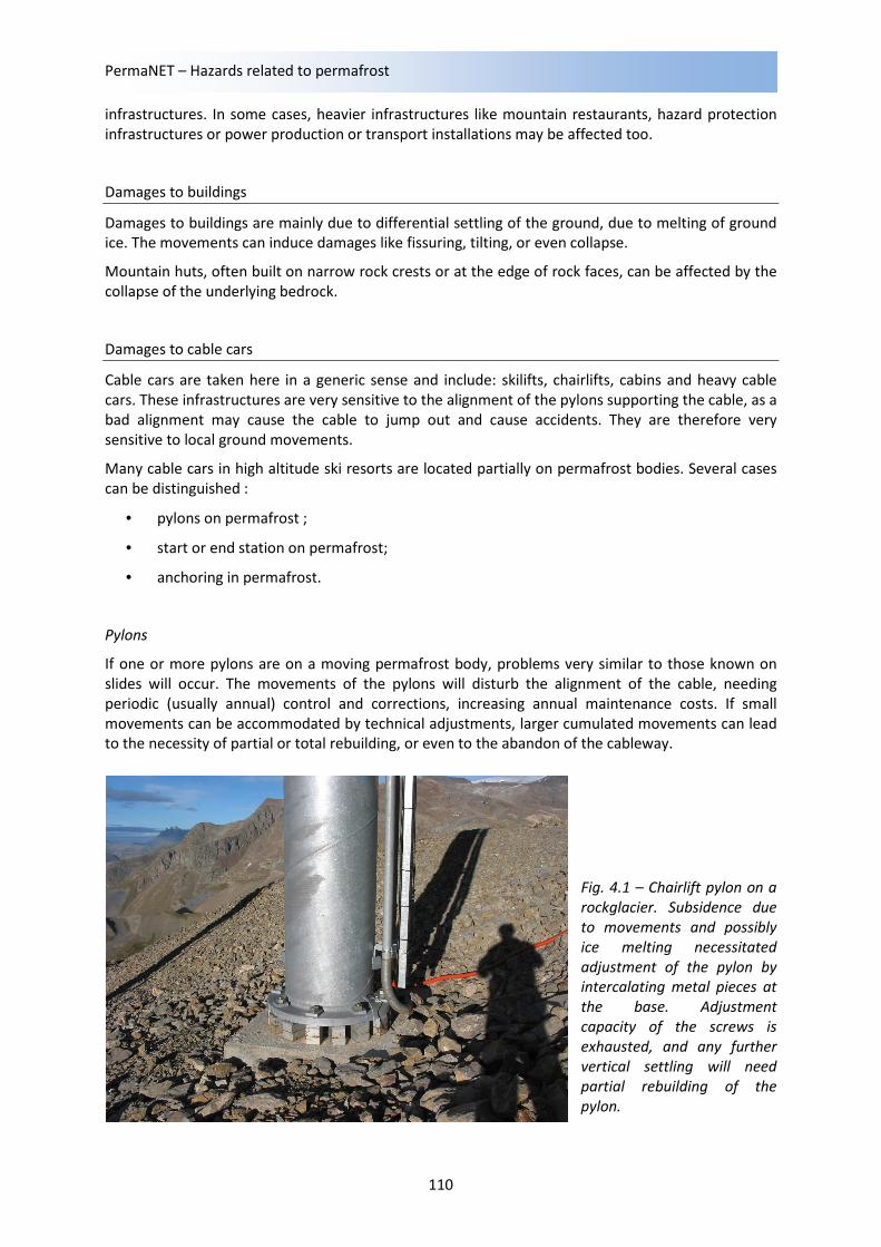
Pylons
If one or more pylons are on a moving permafrost body, problems very similar to those known on
slides will occur. The movements of the pylons will disturb the alignment of the cable, needing
periodic (usually annual) control and corrections, increasing annual maintenance costs. If small
movements can be accommodated by technical adjustments, larger cumulated movements can lead
to the necessity of partial or total rebuilding, or even to the abandon of the cableway.
Fig. 4.1 – Chairlift pylon on a
rockglacier. Subsidence due
to movements and possibly
ice melting necessitated
adjustment of the pylon by
intercalating metal pieces at
the base. Adjustment
capacity of the screws is
exhausted, and any further
vertical settling will need
partial rebuilding of the
pylon.
Local ground movements and effects on infrastructures
111
The problems should be smaller if movements occur in the direction of the cable. But it has to be
noted that even small differential movements at the base of the pylon can be amplified on its top by
tilting of the pylon in any direction, regardless to the direction of the ground movement.
Start or end station
The problems are almost the same as for pylons and can affect the alignment of the cable. In
addition, stations are prone to settling of the ground, due to the thermal disturbance of the
permafrost due to the station.
In case of important movements, they could affect the tension of the cable, or even the stability of
the station.
Anchoring
Anchoring concerns only heavy cable cars, e.g. the different kinds of cabins. In most cases, anchoring
and even pylons will be placed on bedrock, and for large installations, geotechnical investigations will
be made before building. It has however to be mentioned, that even anchoring in frozen bedrock
needs special measures, in order to avoid to enhance melting and weakening of the bedrock (e.g.
case of Klein Matterhorn).
A weakening of the anchoring, due to melting of the permafrost or to local movements, can
endanger the stability and the security of the whole installation.
As mentioned above, current problems are usually very moderate and can be solved by annual
maintenance, inducing an additional maintenance cost. In some cases partial or total rebuilding or
even abandonment of the infrastructure will be necessary. The hazard for persons is almost absent
and no accident due to permafrost creep induced causes is reported yet. It has to be emphasized,
however, that rock-glacier accelerations or even collapse, due to permafrost warming, could
significantly increase the damages in the future, or even cause a threat to security (see chapter on
rock-glaciers for more details on velocity variations).
Damages to hazard protections
Avalanche defense structures in permafrost
Avalanche defense structures are built to retain snow in steep avalanche starting zones. These are
frequently located at high altitude sites, with unstable ice-bearing permafrost substrates. As costly
damage induced by creep and rock fall has frequently been observed, special guidelines for the
construction and maintenance of the structures in permafrost have been developed in Switzerland
(Margreth 2007) with the aim of improving their performance and prolonging their service life. The
guidelines include specifications on methods of permafrost detection, the type of structures and
foundations to be used, suitable construction techniques and on various types of monitoring
methods. In particular, the use of flexible snow nets is recommended, in combination with floating
foundations and specifically developed grout for anchors at sub-zero ground temperatures. The
contents of the guidelines are based on results obtained from long-term observations and
measurements carried out at sites equipped with avalanche defense structures in the Swiss Alps (e.g.
Phillips 2006; Phillips and Margreth 2008). The avalanche defense site Wisse Schijen has for example
been investigated thoroughly since 1998 and the results are summarized in the case study section.
PermaNET – Hazards related to permafrost
112
Earthwork induced « thermokarst »
In the Arctic, the permafrost is known to be very sensitive to any change in surface conditions. This is
particularly true in the discontinuous permafrost belt, where the permafrost is covered by soil and
vegetation and is in a very precarious equilibrium with climate. Any even small change in the thermal
properties of the surface and of the active layer may have dramatic impacts on the thermal regime of
the active layer and hence on the permafrost. The peaty soil of this zone is characterized by a very
low thermal conductivity and provides a high insulation, so any disturbance of the soil layer will
increase heat penetration. Changes in surface albedo are known too to have a high impact on
radiation absorption and hence on the thermal regime of the underlying layers. The forest cover
plays also a role in the regulation of surface temperatures, and extensive logging is known to be a
potential trigger of extensive permafrost melting. These effects can have a very high spatial
variability due to the uneven ground ice distribution (ice-wedges and lenses). All this is well known
especially through numerous experiences with road constructions, railways, pipe-lines, but also
forest logging, etc.
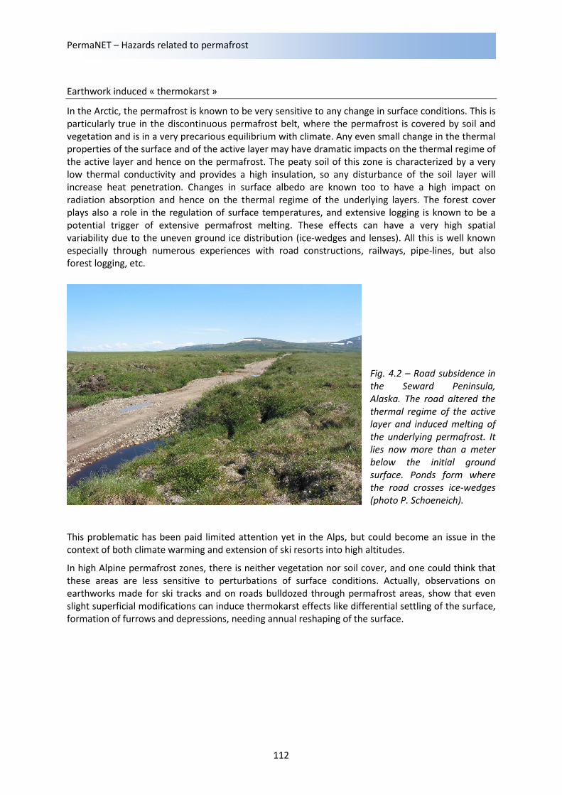
Fig. 4.2 – Road subsidence in
the Seward Peninsula,
Alaska. The road altered the
thermal regime of the active
layer and induced melting of
the underlying permafrost. It
lies now more than a meter
below the initial ground
surface. Ponds form where
the road crosses ice-wedges
(photo P. Schoeneich).
This problematic has been paid limited attention yet in the Alps, but could become an issue in the
context of both climate warming and extension of ski resorts into high altitudes.
In high Alpine permafrost zones, there is neither vegetation nor soil cover, and one could think that
these areas are less sensitive to perturbations of surface conditions. Actually, observations on
earthworks made for ski tracks and on roads bulldozed through permafrost areas, show that even
slight superficial modifications can induce thermokarst effects like differential settling of the surface,
formation of furrows and depressions, needing annual reshaping of the surface.
Local ground movements and effects on infrastructures
113
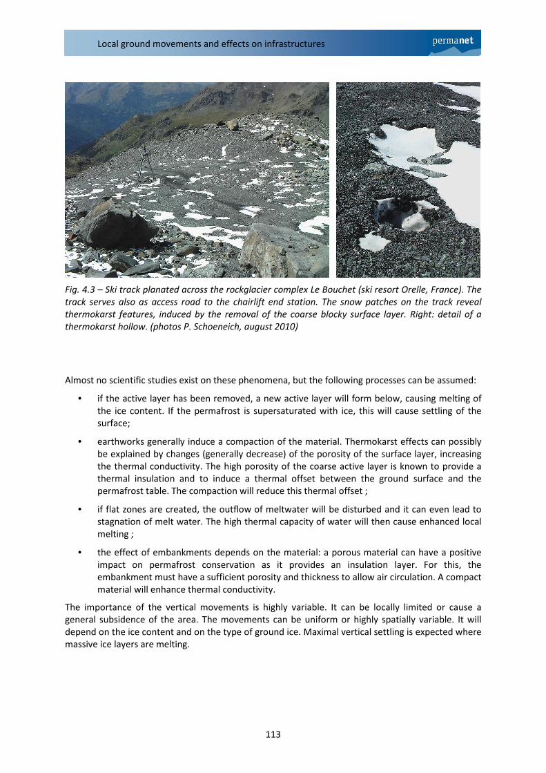
Fig. 4.3 – Ski track planated across the rockglacier complex Le Bouchet (ski resort Orelle, France). The
track serves also as access road to the chairlift end station. The snow patches on the track reveal
thermokarst features, induced by the removal of the coarse blocky surface layer. Right: detail of a
thermokarst hollow. (photos P. Schoeneich, august 2010)
Almost no scientific studies exist on these phenomena, but the following processes can be assumed:
• if the active layer has been removed, a new active layer will form below, causing melting of
the ice content. If the permafrost is supersaturated with ice, this will cause settling of the
surface;
• earthworks generally induce a compaction of the material. Thermokarst effects can possibly
be explained by changes (generally decrease) of the porosity of the surface layer, increasing
the thermal conductivity. The high porosity of the coarse active layer is known to provide a
thermal insulation and to induce a thermal offset between the ground surface and the
permafrost table. The compaction will reduce this thermal offset ;
• if flat zones are created, the outflow of meltwater will be disturbed and it can even lead to
stagnation of melt water. The high thermal capacity of water will then cause enhanced local
melting ;
• the effect of embankments depends on the material: a porous material can have a positive
impact on permafrost conservation as it provides an insulation layer. For this, the
embankment must have a sufficient porosity and thickness to allow air circulation. A compact
material will enhance thermal conductivity.
The importance of the vertical movements is highly variable. It can be locally limited or cause a
general subsidence of the area. The movements can be uniform or highly spatially variable. It will
depend on the ice content and on the type of ground ice. Maximal vertical settling is expected where
massive ice layers are melting.
PermaNET – Hazards related to permafrost
114
3. Case studies
3.1 France
The Bouchet chairlift
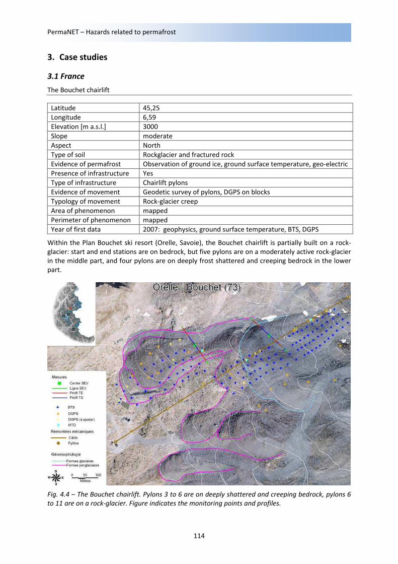
Within the Plan Bouchet ski resort (Orelle, Savoie), the Bouchet chairlift is partially built on a rock-
glacier: start and end stations are on bedrock, but five pylons are on a moderately active rock-glacier
in the middle part, and four pylons are on deeply frost shattered and creeping bedrock in the lower
part.
Fig. 4.4 – The Bouchet chairlift. Pylons 3 to 6 are on deeply shattered and creeping bedrock, pylons 6
to 11 are on a rock-glacier. Figure indicates the monitoring points and profiles.
Latitude 45,25
Longitude 6,59
Elevation [m a.s.l.] 3000
Slope moderate
Aspect North
Type of soil Rockglacier and fractured rock
Evidence of permafrost Observation of ground ice, ground surface temperature, geo-electric
Presence of infrastructure Yes
Type of infrastructure Chairlift pylons
Evidence of movement Geodetic survey of pylons, DGPS on blocks
Typology of movement Rock-glacier creep
Area of phenomenon mapped
Perimeter of phenomenon mapped
Year of first data 2007: geophysics, ground surface temperature, BTS, DGPS
Local ground movements and effects on infrastructures
115
Shortly after construction works the first movements and disturbances were noticed, and in 2005 a
geotechnical investigation showed the occurrence of ground ice in trenches at 3.6 m below the
surface. Movements of pylons are monitored annually and show ground displacements in the
decimeter range, with a maximum of 16 cm y-1
. The ground movements occur almost in the direction
of the cable, so that disturbances are limited. Alignment of cable has to be controlled and adjusted
annually. The chairlift functions only in winter. Adjustment occurs at the end of summer/early
winter.
Since 2007, the Bouchet rock-glacier has been monitored for ground surface temperature, surface
displacements (in addition to the geodetic survey of the pylons) and two geophysical surveys have
been performed in 2007 and 2009.
The presence of ground ice is confirmed by occurrence in exploration trenches in the vicinity of
pylons, by frequent occurrences during planation works on neighbouring ski tracks, and is supported
by high resistivity in geoelectrical tomographies. The thickness of the coarse blocky active layer can
be placed by the seismic interface at 4 to 8 m.
Surface displacements measured by DGPS range from <3 to 20 cm.a-1
, in the same range as geodetic
measurements on pylons, and vertical settling of a few cm y-1
.
On the ski tracks crossing the rockglacier area, extensive thermokarst features are observed. The
surface of the ski tracks is regularly reshaped by bulldozers, in order to planate the thermokarst
induced irregularities.
The Bellecombes chairlift
Within the ski resort of Deux Alpes (Isère), the Bellecombes chairlift is partially built on a rockglacier :
the start station and the lower and middle parts of the lift are on bedrock. The three last pylons and
the end station are on a moderately active rockglacier.
The present chairlift replaces an older one that had to be replaced because of disturbances due to
ground movements. Before building the new chairlift, geotechnical investigations have therefore
been undertaken, and the location chosen in order to minimize disturbances. Most of the lift could
be placed on bedrock, but the uppermost part with the end station had to be placed on a bi-lobate
rock-glacier, on a flat area just above the separation of the two rock-glacier lobes.
A 2 to 4 m thick ice lens was encountered below a 4 m thick coarse blocky layer during foundation
excavation of the end station, and totally removed.
Latitude 44,99
Longitude 6,16
Elevation [m a.s.l.] 2710
Slope moderate
Aspect North
Type of soil Rock-glacier and fractured rock
Evidence of permafrost Observation of ground ice, ground surface temperature, geo-electric
Presence of infrastructure Yes
Type of infrastructure Chairlift pylons
Evidence of movement Geodetic survey of pylons, DGPS on blocks
Typology of movement Rock-glacier creep
Area of phenomenon mapped
Perimeter of phenomenon mapped
Year of first data 2007: geophysics, ground surface temperature, BTS, DGPS
PermaNET – Hazards related to permafrost
116
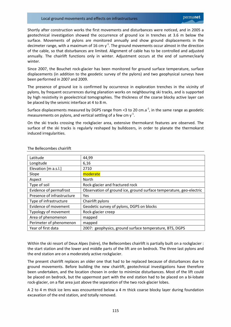
Fig. 4.5 – Left : the top of the Bellecombes chairlift, with the last pylons and the end station on a
rockglacier. Right : ice layer found at 4 m depth during construction of the end station.
Pylons show movements in the decimeter range, the end station slight settling in addition. Cable
alignment is controlled and adjusted annually at the end of summer/early autumn. The chairlift
functions in winter only.
The rock-glacier has been monitored since 2007 for ground surface temperatures, surface
displacements (in addition to the geodetic survey of the pylons) and two geophysical surveys have
been performed in 2007 and 2009.
Two boreholes have been drilled in 2009 in the vicinity of the end station, through the left lobe of the
rock-glacier. They both show a 2 m thick coarse blocky and ice-free active layer, overlying 7-8 m of
pure ice in the lower borehole and of an ice rich ice-rock mixture in the upper borehole, with bedrock
at around 10 m. These boreholes show that the total ice thickness exceeds the observed thickness in
the excavation, and that the ground ice underlying the end station has probably not been totally
removed during construction.
The presence of ground ice was attested during the excavation, the two boreholes and thermokarst
phenomena on the ski track just beneath the end station. The presence and extent of a pure ice or
very ice-rich permafrost layer is supported by the very high resistivity encountered in all ERT profiles.
The thickness of the active layer is consistent with the seismic interface and shows a nearly constant
depth of ca 3 m.
Ground surface temperature monitoring indicates a high probability of permafrost, with strongly
negative winter equilibrium temperatures. BTS mapping shows a clear ground surface temperature
contrast between the cold rockglacier and the warmer surrounding bedrock and debris slope. The
geomorphological and thermal limits are consistent with the limits of movements given by DGPS
survey, with values in the cm to dm y-1
range.
The Bellecombes chairlift illustrates the problematic of foundation work on rock-glaciers and more
generally on frozen debris. An ice layer was found during the excavation and removed before
building, but in the absence of a drilling it remains unknown if there is more ice beneath. ERT or
electrical soundings reveal the probable presence of ground ice, but the very high resistivity of the
pure ice lens leads to overestimate its thickness. Finally, only a borehole can give a reliable
knowledge on foundation conditions, like thickness of ice-rich layers and depth of bedrock.
Local ground movements and effects on infrastructures
117
3.2 Italy
Rifugio Ai Caduti dell’Adamello
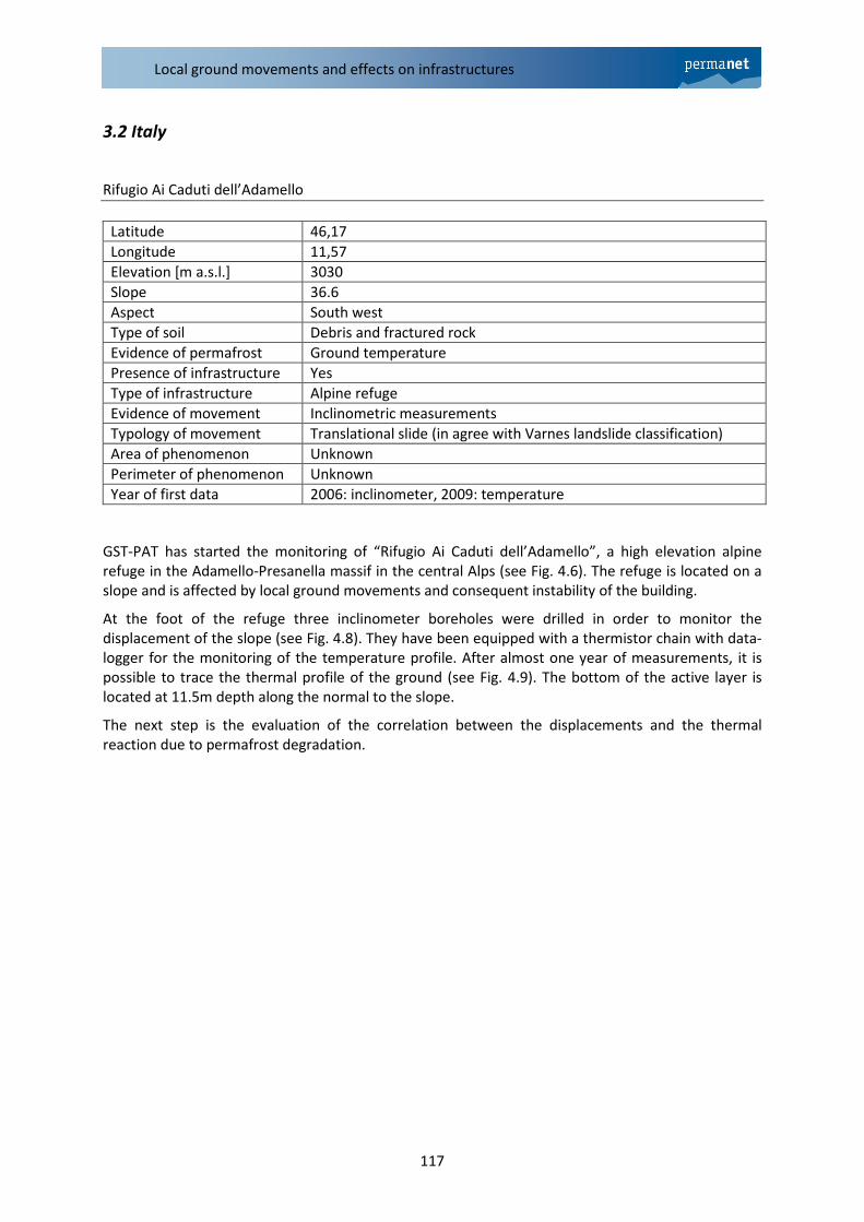
GST-PAT has started the monitoring of “Rifugio Ai Caduti dell’Adamello”, a high elevation alpine
refuge in the Adamello-Presanella massif in the central Alps (see Fig. 4.6). The refuge is located on a
slope and is affected by local ground movements and consequent instability of the building.
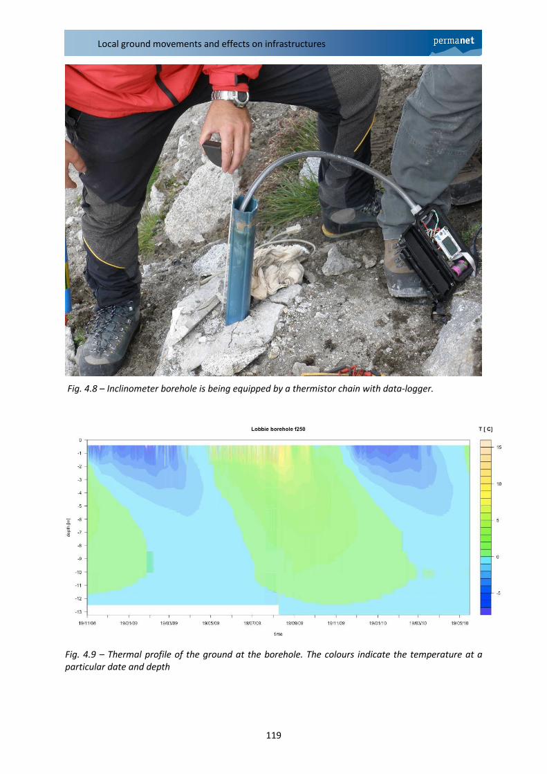
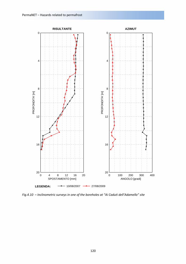
At the foot of the refuge three inclinometer boreholes were drilled in order to monitor the
displacement of the slope (see Fig. 4.8). They have been equipped with a thermistor chain with data-
logger for the monitoring of the temperature profile. After almost one year of measurements, it is
possible to trace the thermal profile of the ground (see Fig. 4.9). The bottom of the active layer is
located at 11.5m depth along the normal to the slope.
The next step is the evaluation of the correlation between the displacements and the thermal
reaction due to permafrost degradation.
Latitude 46,17
Longitude 11,57
Elevation [m a.s.l.] 3030
Slope 36.6
Aspect South west
Type of soil Debris and fractured rock
Evidence of permafrost Ground temperature
Presence of infrastructure Yes
Type of infrastructure Alpine refuge
Evidence of movement Inclinometric measurements
Typology of movement Translational slide (in agree with Varnes landslide classification)
Area of phenomenon Unknown
Perimeter of phenomenon Unknown
Year of first data 2006: inclinometer, 2009: temperature
PermaNET – Hazards related to permafrost
118
Fig. 4.6 – Alpine refuge "Ai Caduti dell'Adamello" 3030m lies on a slope subject to local ground
movements.
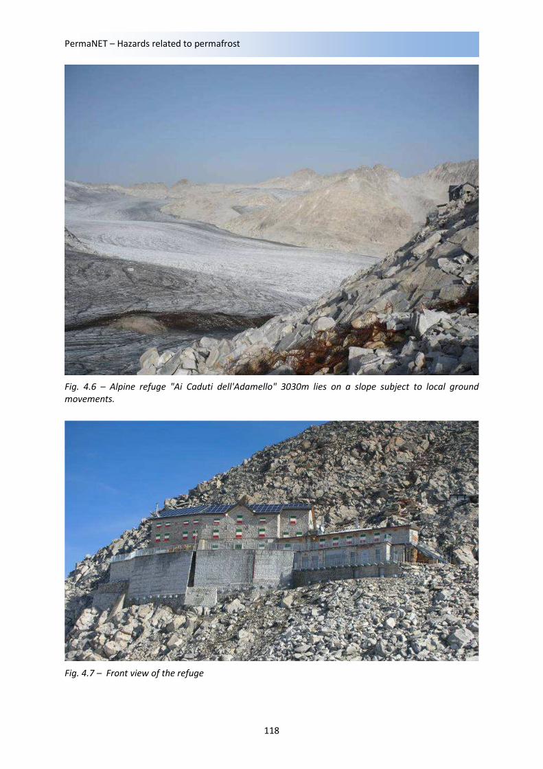
Fig. 4.7 – Front view of the refuge
Local ground movements and effects on infrastructures
119
Fig. 4.8 – Inclinometer borehole is being equipped by a thermistor chain with data-logger.
Fig. 4.9 – Thermal profile of the ground at the borehole. The colours indicate the temperature at a
particular date and depth
PermaNET – Hazards related to permafrost
120
LEGENDA:
0 204 8 12 16
0
20
4
8
12
16
SPOSTAMENTO [mm]
PR
OF
ON
DIT
A' [
m]
RISULTANTE
0 400100 200 300
0
20
4
8
12
16
ANGOLO [gradi]
PR
OF
ON
DIT
A' [
m]
AZIMUT
10/08/2007 27/08/2009
Fig.4.10 – Inclinometric surveys in one of the boreholes at “Ai Caduti dell’Adamello” site
Local ground movements and effects on infrastructures
121
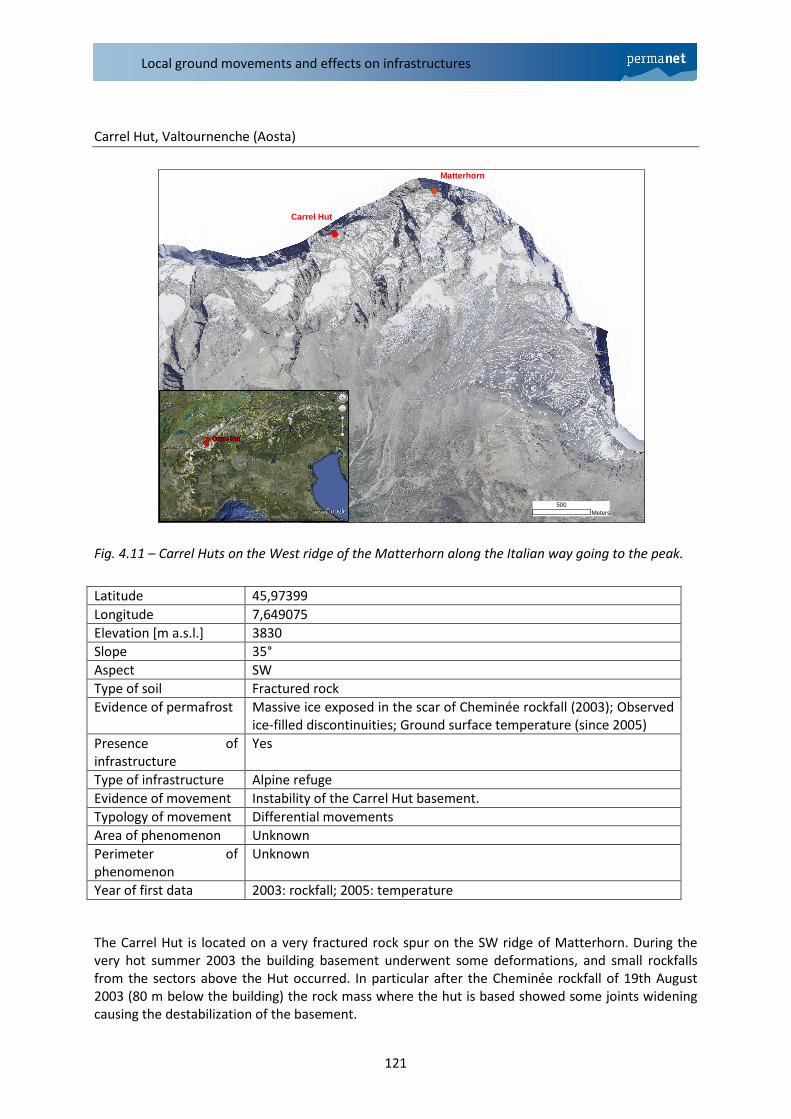
Carrel Hut, Valtournenche (Aosta)
Fig. 4.11 – Carrel Huts on the West ridge of the Matterhorn along the Italian way going to the peak.
The Carrel Hut is located on a very fractured rock spur on the SW ridge of Matterhorn. During the
very hot summer 2003 the building basement underwent some deformations, and small rockfalls
from the sectors above the Hut occurred. In particular after the Cheminée rockfall of 19th August
2003 (80 m below the building) the rock mass where the hut is based showed some joints widening
causing the destabilization of the basement.
Latitude 45,97399
Longitude 7,649075
Elevation [m a.s.l.] 3830
Slope 35°
Aspect SW
Type of soil Fractured rock
Evidence of permafrost Massive ice exposed in the scar of Cheminée rockfall (2003); Observed
ice-filled discontinuities; Ground surface temperature (since 2005)
Presence of
infrastructure
Yes
Type of infrastructure Alpine refuge
Evidence of movement Instability of the Carrel Hut basement.
Typology of movement Differential movements
Area of phenomenon Unknown
Perimeter of
phenomenon
Unknown
Year of first data 2003: rockfall; 2005: temperature
Carrel Hut
Matterhorn
500Meters
PermaNET – Hazards related to permafrost
122
Fig. 4.12 – Left: The Cheminée after the rockfall of 19/08/2003. The water below the Cheminée comes
from the melting of the ice lens uncovered by the rockfall.. Right: Rock mass under the hut basement
after the Cheminée rockfall.
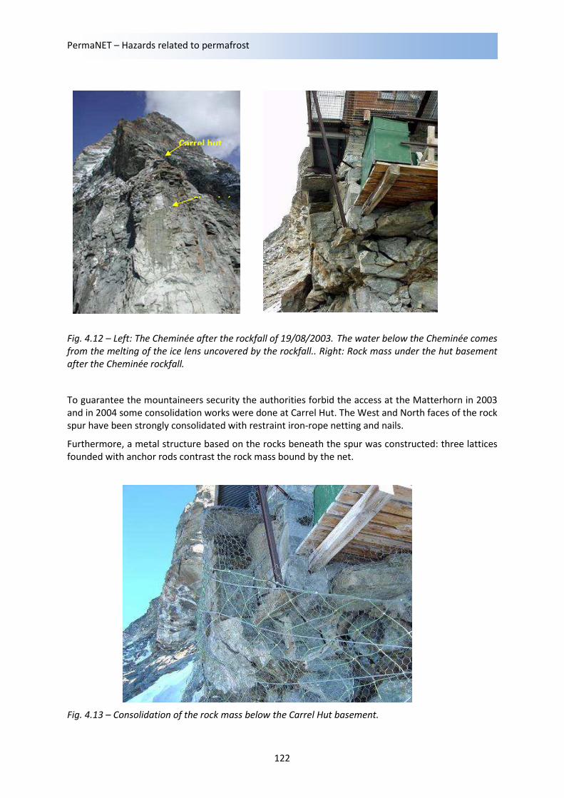
To guarantee the mountaineers security the authorities forbid the access at the Matterhorn in 2003
and in 2004 some consolidation works were done at Carrel Hut. The West and North faces of the rock
spur have been strongly consolidated with restraint iron-rope netting and nails.
Furthermore, a metal structure based on the rocks beneath the spur was constructed: three lattices
founded with anchor rods contrast the rock mass bound by the net.
Fig. 4.13 – Consolidation of the rock mass below the Carrel Hut basement.
Carrel hut
Cheminée
Local ground movements and effects on infrastructures
123
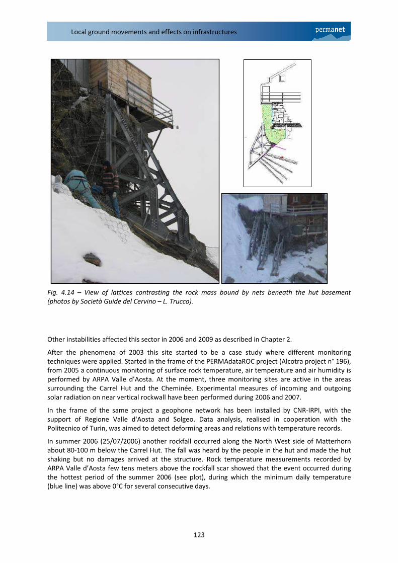
Fig. 4.14 – View of lattices contrasting the rock mass bound by nets beneath the hut basement
(photos by Società Guide del Cervino – L. Trucco).
Other instabilities affected this sector in 2006 and 2009 as described in Chapter 2.
After the phenomena of 2003 this site started to be a case study where different monitoring
techniques were applied. Started in the frame of the PERMAdataROC project (Alcotra project n° 196),
from 2005 a continuous monitoring of surface rock temperature, air temperature and air humidity is
performed by ARPA Valle d’Aosta. At the moment, three monitoring sites are active in the areas
surrounding the Carrel Hut and the Cheminée. Experimental measures of incoming and outgoing
solar radiation on near vertical rockwall have been performed during 2006 and 2007.
In the frame of the same project a geophone network has been installed by CNR-IRPI, with the
support of Regione Valle d'Aosta and Solgeo. Data analysis, realised in cooperation with the
Politecnico of Turin, was aimed to detect deforming areas and relations with temperature records.
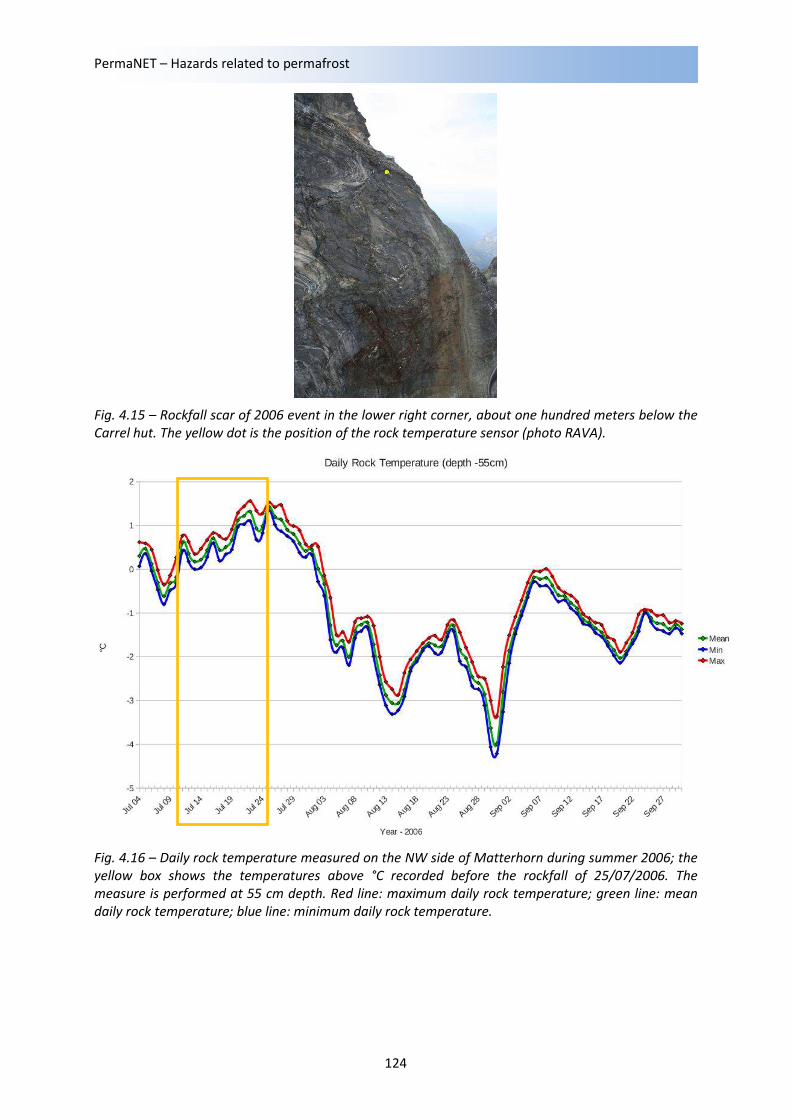
In summer 2006 (25/07/2006) another rockfall occurred along the North West side of Matterhorn
about 80-100 m below the Carrel Hut. The fall was heard by the people in the hut and made the hut
shaking but no damages arrived at the structure. Rock temperature measurements recorded by
ARPA Valle d’Aosta few tens meters above the rockfall scar showed that the event occurred during
the hottest period of the summer 2006 (see plot), during which the minimum daily temperature
(blue line) was above 0°C for several consecutive days.
PermaNET – Hazards related to permafrost
124
Fig. 4.15 – Rockfall scar of 2006 event in the lower right corner, about one hundred meters below the
Carrel hut. The yellow dot is the position of the rock temperature sensor (photo RAVA).
Fig. 4.16 – Daily rock temperature measured on the NW side of Matterhorn during summer 2006; the
yellow box shows the temperatures above °C recorded before the rockfall of 25/07/2006. The
measure is performed at 55 cm depth. Red line: maximum daily rock temperature; green line: mean
daily rock temperature; blue line: minimum daily rock temperature.
Local ground movements and effects on infrastructures
125
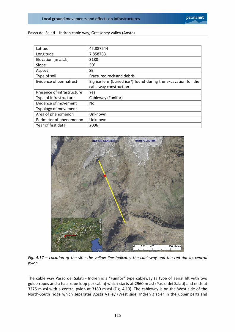
Passo dei Salati – Indren cable way, Gressoney valley (Aosta)
Fig. 4.17 – Location of the site: the yellow line indicates the cableway and the red dot its central
pylon.
The cable way Passo dei Salati - Indren is a "Funifor" type cableway (a type of aerial lift with two
guide ropes and a haul rope loop per cabin) which starts at 2960 m asl (Passo dei Salati) and ends at
3275 m asl with a central pylon at 3180 m asl (Fig. 4.19). The cableway is on the West side of the
North-South ridge which separates Aosta Valley (West side, Indren glacier in the upper part) and
Latitud 45.887244
Longitude 7.858783
Elevation [m a.s.l.] 3180
Slope 30°
Aspect SE
Type of soil Fractured rock and debris
Evidence of permafrost Big ice lens (buried ice?) found during the excavation for the
cableway construction
Presence of infrastructure Yes
Type of infrastructure Cableway (Funifor)
Evidence of movement No
Typology of movement -
Area of phenomenon Unknown
Perimeter of phenomenon Unknown
Year of first data 2006
PermaNET – Hazards related to permafrost
126
Piedmont (East side, Bors glacier in the upper part). The site is characterised by other rock spurs and
ridges covered by coarse debris material (thickness up to 3 m) of both morainic and talus origin.
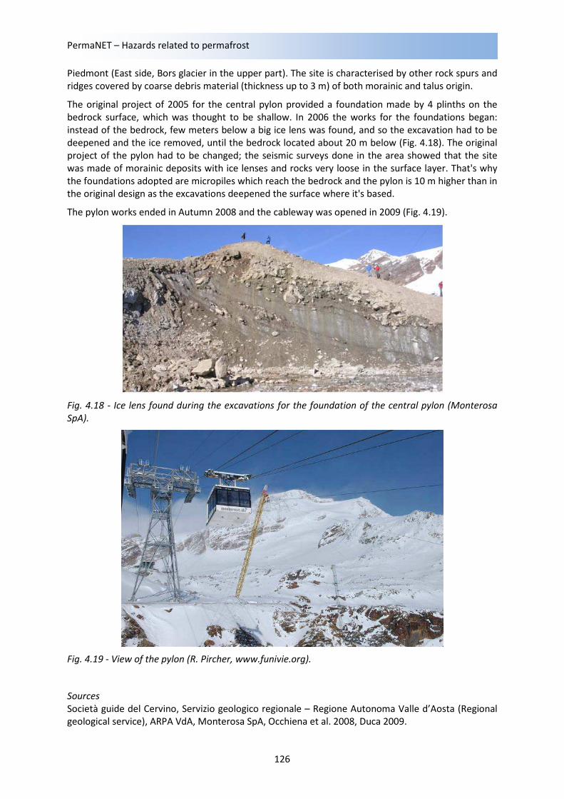
The original project of 2005 for the central pylon provided a foundation made by 4 plinths on the
bedrock surface, which was thought to be shallow. In 2006 the works for the foundations began:
instead of the bedrock, few meters below a big ice lens was found, and so the excavation had to be
deepened and the ice removed, until the bedrock located about 20 m below (Fig. 4.18). The original
project of the pylon had to be changed; the seismic surveys done in the area showed that the site
was made of morainic deposits with ice lenses and rocks very loose in the surface layer. That's why
the foundations adopted are micropiles which reach the bedrock and the pylon is 10 m higher than in
the original design as the excavations deepened the surface where it's based.
The pylon works ended in Autumn 2008 and the cableway was opened in 2009 (Fig. 4.19).
Fig. 4.18 - Ice lens found during the excavations for the foundation of the central pylon (Monterosa
SpA).
Fig. 4.19 - View of the pylon (R. Pircher, www.funivie.org).
Sources
Società guide del Cervino, Servizio geologico regionale – Regione Autonoma Valle d’Aosta (Regional
geological service), ARPA VdA, Monterosa SpA, Occhiena et al. 2008, Duca 2009.
Local ground movements and effects on infrastructures
127
Belvedere glacier and Monte Rosa east face (Piedmont, Italy)
Latitude 45.94
Longitude 8.01
Elevation [m a.s.l.] 2,063 ÷ 4,503
Slope 42° (about)
Aspect E ÷ NE
Type of soil Rocks and debris
Evidence of permafrost Indirect
Presence of
infrastructure
Yes
Type of infrastructure Alpine shelters
Evidence of movement Inclination of the structures
Typology of movement Debris slide and flow and other complex phenomena
Area of phenomenon Unknown
Perimeter of
phenomenon
Unknown
Year of first data 1960’s
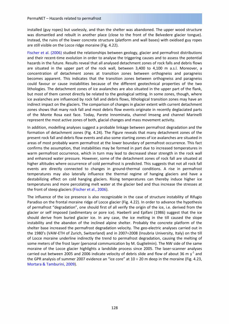
The Monte Rosa east face is one of the highest flanks in the Alps (2,200 ÷ 4,500 m a.s.l.), situated in
the upper Valle Anzasca above the village of Macugnaga, northern Italy (Fig. 4.20). Steep hanging
glaciers and permafrost cover large parts of the wall. Since the end of the Little Ice Age (about 1850),
the hanging glaciers and firn fields have retreated continuously. The Belvedere glacier is located at
the foot of the Monte Rosa east face. It is a humid-temperate, heavily debris-covered glacier fed by
hanging glaciers, ice and snow avalanches as well as rock falls from the Monte Rosa east face (Fig.
4.21).
During recent decades, the ice cover of the Monte Rosa east face experienced an accelerated and
drastic loss in extension. Some glaciers have completely disappeared. New slope instabilities and
detachment zones of gravitational mass movements developed and enhanced rock fall and debris
flow activity was observed. Also the permafrost distribution, even though not directly visible, is
believed to have experienced changes in extent and ground-temperatures, as in large parts of the
European Alps (Harris et al., 2003).
Belvedere glacier also experienced a dramatic evolution in recent years. Between summer 2000 and
summer 2001, it started a surge-type movement with ice velocities increasing by one order of
magnitude and showed in parts a strongly uplifted glacier surface by 10 to 25 m. At the foot of the
Monte Rosa east face, however, a large depression developed on the Belvedere glacier and the
glacier surface was lowered by 15 to 35 m. Possibly, as a consequence of enhanced englacial water
pressure or other processes related to the surge-type movement, the supraglacial lake Effimero
formed in this depression on the glacier in September 2001 and in the following two summers with a
maximum volume of 3×10⁶ m
3. Also the moraines are locally involved in landslide processes due to
the underground ice melting and glacier mass modifications.
All these slope instability processes (linked to both glacial and periglacial environments) involved
directly or indirectly some infrastructures. At the foot of the Mt. Rosa east face, close to the right
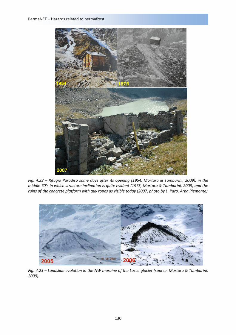
moraine of Belvedere glacier, two alpine shelters are located: the “Rifugio Paradiso” (2,247 m a.s.l.)
and the “Rifugio Zamboni-Zappa” (2,070 m a.s.l.). Actually, the Rifugio Paradiso is abandoned since
1975 due to moraine instability that compromised the infrastructure stability. This shelter was built
in 1958 at the top of the moraine ridge of Locce glacier and during the following years the creep of
the debris caused the slow inclination of the structure. Initially, some mitigation measures were
PermaNET – Hazards related to permafrost
128
installed (guy ropes) but uselessly, and than the shelter was abandoned. The upper wood structure
was dismantled and rebuilt in another place (close to the front of the Belvedere glacier tongue).
Instead, the ruins of the lower concrete structure (platform and wall bases) with oxidised guy ropes
are still visible on the Locce ridge moraine (Fig. 4.22).
Fischer et al. (2006) studied the relationships between geology, glacier and permafrost distributions
and their recent-time evolution in order to analyse the triggering causes and to assess the potential
hazards in the future. Results reveal that all analysed detachment zones of rock falls and debris flows
are situated in the upper part of the rock wall, between 3,400 to 4,100 m a.s.l. Moreover, a
concentration of detachment zones at transition zones between orthogneiss and paragneiss
becomes apparent. This indicates that the transition zones between orthogneiss and paragneiss
could favour or cause instabilities because of the different geotechnical properties of the two
lithologies. The detachment zones of ice avalanches are also situated in the upper part of the flank,
but most of them cannot directly be related to the geological setting. In some zones, though, where
ice avalanches are influenced by rock fall and debris flows, lithological transition zones may have an
indirect impact on the glaciers. The comparison of changes in glacier extent with current detachment
zones shows that many rock fall and most debris flow events originate in recently deglaciated parts
of the Monte Rosa east face. Today, Parete Innominata, channel Imseng and channel Marinelli
represent the most active zones of both, glacial changes and mass movement activity.
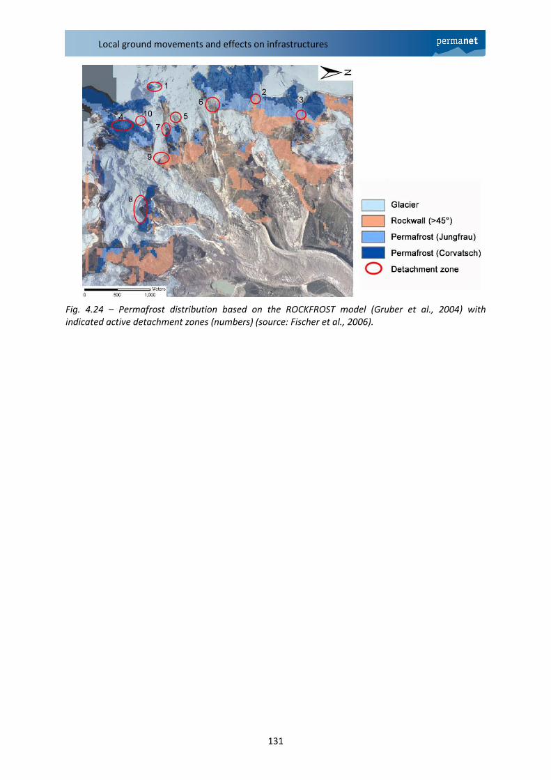
In addition, modelling analyses suggest a probable linkage between permafrost degradation and the
formation of detachment zones (Fig. 4.24). The Figure reveals that many detachment zones of the
present rock fall and debris flow events and also some starting zones of ice avalanches are situated in
areas of most probably warm permafrost at the lower boundary of permafrost occurrence. This fact
confirms the assumption, that instabilities may be formed in part due to increased temperatures in
warm permafrost occurrence, which in turn may lead to decreased shear strength in the rock wall
and enhanced water pressure. However, some of the detachment zones of rock fall are situated at
higher altitudes where occurrence of cold permafrost is predicted. This suggests that not all rock fall
events are directly connected to changes in ground-thermal conditions. A rise in permafrost
temperatures may also laterally influence the thermal regime of hanging glaciers and have a
destabilizing effect on cold hanging glaciers. Rising temperatures can thereby induce higher ice
temperatures and more percolating melt water at the glacier bed and thus increase the stresses at
the front of steep glaciers (Fischer et al., 2006).
The influence of the ice presence is also recognizable in the case of structure instability of Rifugio
Paradiso on the frontal moraine ridge of Locce glacier (Fig. 4.22). In order to advance the hypothesis
of permafrost “degradation”, one should first of all verify the origin of the ice, i.e. derived from the
glacier or self imposed (sedimentary or pore ice). Haeberli and Epifani (1986) suggest that the ice
should derive from buried glacier ice. In any case, the ice melting in the till caused the slope
instability and the abandon of the inclined alpine shelter. Probably the concrete platform of the
shelter base increased the permafrost degradation velocity. The geo-electric analyses carried out in
the 1980’s (VAW-ETH of Zurich, Switzerland) and in 2007÷2008 (Insubria University, Italy) on the till
of Locce moraine underline indirectly the trend to permafrost degradation, causing the melting of
some meters of the frost layer (personal communication by M. Guglielmin). The NW side of the same
moraine of the Locce glacier highlights a landslide process since 2005. The laser-scanner analyses
carried out between 2005 and 2006 indicate velocity of debris slide and flow of about 36 m y-1
and
the GPR analysis of summer 2007 evidence an “ice core” at 10 ÷ 20 m deep in the moraine (Fig. 4.23,
Mortara & Tamburini, 2009).
Local ground movements and effects on infrastructures
129
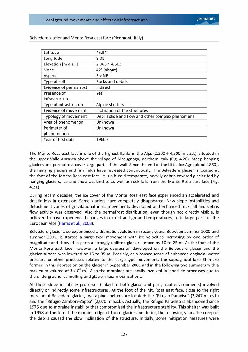
Fig. 4.20 – Sketch map of the investigated area (source: Fischer et al., 2006).
Fig. 4.21 – Mt. Rosa east face and the Belvedere glacier (source: G. Mortara, CNR-IRPI).
PermaNET – Hazards related to permafrost
130
Fig. 4.22 – Rifugio Paradiso some days after its opening (1954, Mortara & Tamburini, 2009), in the
middle 70’s in which structure inclination is quite evident (1975, Mortara & Tamburini, 2009) and the
ruins of the concrete platform with guy ropes as visible today (2007, photo by L. Paro, Arpa Piemonte)
Fig. 4.23 – Landslide evolution in the NW moraine of the Locce glacier (source: Mortara & Tamburini,
2009).
Local ground movements and effects on infrastructures
131
Fig. 4.24 – Permafrost distribution based on the ROCKFROST model (Gruber et al., 2004) with
indicated active detachment zones (numbers) (source: Fischer et al., 2006).
PermaNET – Hazards related to permafrost
132
3.3 Austria
Hoher Sonnblick (ZAMG, Salzburg, Austria)
Latitude 47˚ 03’ 14’’
Longitude 12˚57’ 27’’
Elevation [m a.s.l.] 3105
Slope moderate
Aspect S, SE
Type of soil Biotit-Gneiss
Evidence of permafrost direct (measurements)
Presence of infrastructure Yes
Type of infrastructure Cable car station
Year of first data 2007
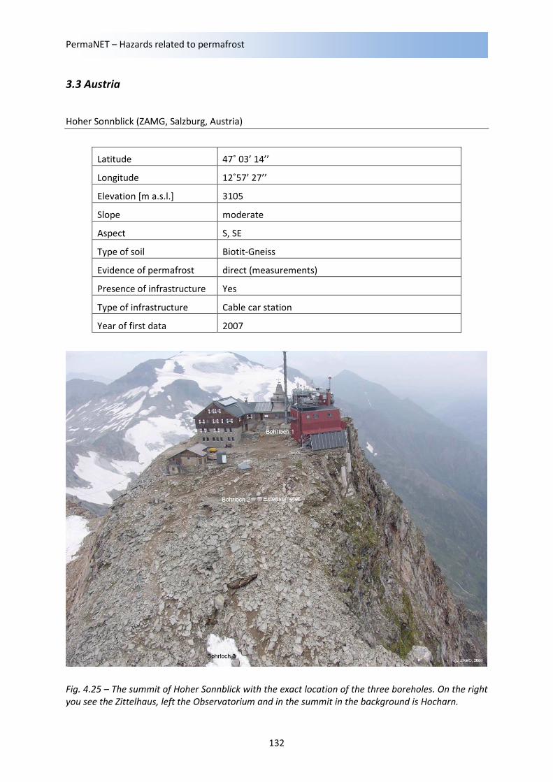
Fig. 4.25 – The summit of Hoher Sonnblick with the exact location of the three boreholes. On the right
you see the Zittelhaus, left the Observatorium and in the summit in the background is Hocharn.
Local ground movements and effects on infrastructures
133
Introduction
The crest of Hoher Sonnblick (3105 m asl) is located in the main chain of the Eastern Alps in the
Region of Hohe Tauern, Austria. The neighbouring mountains of Hoher Sonnblick also reach heights
about 3000 m a.msl. While the north site of Hoher Sonnblick is characterized by a very deep and
steep north face, to the south moderate slope about 30° down to the top margin of the glacier
Goldbergkees can be detected. A picture of Hoher Sonnblick can be seen in Figure 4.25. The
Sonnblick observatory is on the right, the Zittelhaus on the left. The location of the three boreholes is
also marked. In the vicinity of Hoher Sonnblick there are three glaciers. The largest glacier is the
Goldbergkees. It is located to the southeast of the crest and its stream turns in the middle and lower
margin and at last the tongue shows to the North. The second one is called Kleinfleißkees and it looks
towards southwest and the aspect of the third glacier – Pilatuskees – is mainly North. Pilatuskees and
Kleinfleißkees are small without a typical tongue, the Goldbergkees is a bit longer, but the ice break
up one time in the upper section of the glacier and also in the lower part of the glacier. Glacier ice
occurence can be found below 2500 m. The rock in the region consists mainly of biotit-gneiss (Exner,
1964). The thickness of the debris layer around the summit, where the boreholes were drilled, is
about 2 m and less.
The observatory was built in the end of 19th century and a mountain hut, the Zittelhaus, is also
located on top of the summit. In a study in 2001, it was observed that fissuring of the crest demands
for the necessity of a geological stabilization of the steep north face for the protection of the
observatory. This redevelopment was done from 2003 to 2007. The main reason of the fissuring
should be the change in meteorological conditions during the 20th century. Higher temperatures and
more liquid precipitation advances the physical weathering process of the rock. Higher temperature
contrasts causes frost shattering, which is more active than in past times. Climatological
measurements especially of temperature started in 1886. Actually, each year counts 310 freezing
days (daily minimum below 0 degree) and 239 ice days (daily maximum below 0 degree). All values
refer to the period between 1971 and 2000. Up to now it exists an unbroken temperature row.
Beneath the temperature measurements and measurements of other meteorological parameters,
the Sonnblick observatory is a center of several scientific activities. For example measurements in
atmospheric chemistry, snow chemical measurements, mass balance measurements of the
surrounding glaciers, avalanche reports, of course permafrost long-term monitoring since 2007, and
several more activities actually take place on Hoher Sonnblick.
Measurements and results
The relevance of Permafrost-long-term monitoring is widely spread. Climate change in the Alps is not
only related to the retreat of glaciers, but rather to the existence of Permafrost. The temporal
behaviour and other influences or interactions of Permafrost to several kinds of infrastructure, for
example cable lifts, lift stations or mountain huts, signifies a very important knowledge. Furthermore
drinking water reservoirs of Permafrost and their quality and usage for the future in the high
mountain regions can also play an important role.
PermaNET – Hazards related to permafrost
134
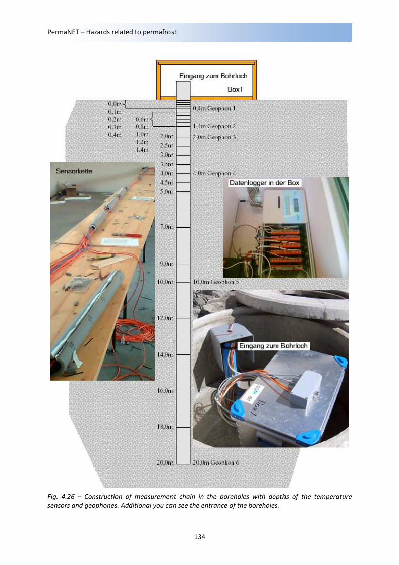
Fig. 4.26 – Construction of measurement chain in the boreholes with depths of the temperature
sensors and geophones. Additional you can see the entrance of the boreholes.
Local ground movements and effects on infrastructures
135
To measure these influences of Permafrost to climate change and the behaviour of Permafrost, on
top of Hoher Sonnblick three 20 m deep boreholes were drilled on 14. and 15. September 2005 and
were equipped with temperature sensors in different depths (see Figure 4.26) at the end of August
2006. Additionally, one 10 m deep borehole next to borehole 2 was drilled and equipped with
extensometers. Daily actualized measurements of temperature data and extensometer data are
online available and can be seen on www.sonnblick.net in the internet. All boreholes are located on
the southern slope (see Figure 4.25). The mean gradient between borehole 1 and 3 is 27° and the
total altitude difference counts 34 m. Borehole 1 is directly located to the Sonnblick observatory,
borehole 3 is adjacent to an continuous snow field and borehole 2 is located between both of them.
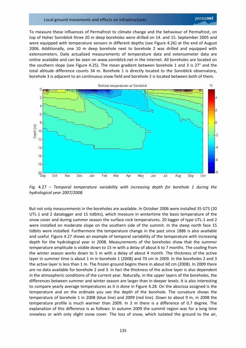
Fig. 4.27 – Temporal temperature variability with increasing depth for borehole 1 during the
hydrological year 2007/2008.
But not only measurements in the boreholes are available. In October 2006 were installed 35 GTS (20
UTL-1 and 2 datalogger and 15 tidbits), which measure in wintertime the basis temperature of the
snow cover and during summer season the surface rock temperatures. 20 logger of type UTL-1 and 2
were installed on moderate slope on the southern side of the summit. In the steep north face 15
tidbits were installed. Furthermore the temperature change in the past since 1886 is also available
and useful. Figure 4.27 shows an example of temporal variability of the temperature with increasing
depth for the hydrological year in 2008. Measurements of the boreholes show that the summer
temperature amplitude is visible down to 15 m with a delay of about 6 to 7 months. The cooling from
the winter season works down to 5 m with a delay of about 4 month. The thickness of the active
layer in summer time is about 1 m in borehole 1 (2008) and 70 cm in 2009. In the boreholes 2 and 3
the active layer is less than 1 m. The frozen ground begins there in about 60 cm (2008). In 2009 there
are no data available for borehole 2 and 3. In fact the thickness of the active layer is also dependent
in the atmospheric conditions of the current year. Naturally, in the upper layers of the boreholes, the
differences between summer and winter season are larger than in deeper levels. It is also interesting
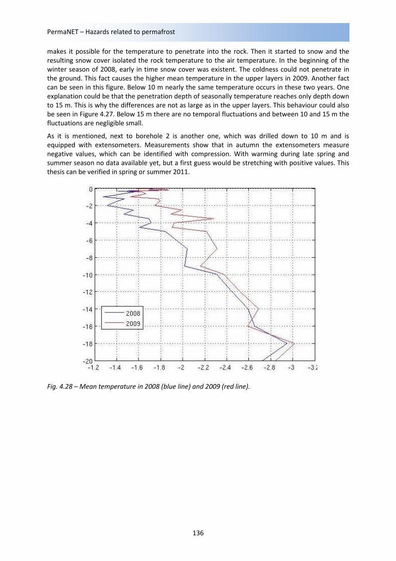
to compare yearly average temperatures as it is done in Figure 4.28. On the abscissa assigned is the
temperature and on the ordinate you see the depth of the borehole. The curvature shows the
temperature of borehole 1 in 2008 (blue line) and 2009 (red line). Down to about 9 m, in 2008 the
temperature profile is much warmer than 2009. In 3 m there is a difference of 0.7 degree. The
explanation of this difference is as follows: In autumn 2009 the summit region was for a long time
snowless or with only slight snow cover. The loss of snow, which isolated the ground to the air,
PermaNET – Hazards related to permafrost
136
makes it possible for the temperature to penetrate into the rock. Then it started to snow and the
resulting snow cover isolated the rock temperature to the air temperature. In the beginning of the
winter season of 2008, early in time snow cover was existent. The coldness could not penetrate in
the ground. This fact causes the higher mean temperature in the upper layers in 2009. Another fact
can be seen in this figure. Below 10 m nearly the same temperature occurs in these two years. One
explanation could be that the penetration depth of seasonally temperature reaches only depth down
to 15 m. This is why the differences are not as large as in the upper layers. This behaviour could also
be seen in Figure 4.27. Below 15 m there are no temporal fluctuations and between 10 and 15 m the
fluctuations are negligible small.
As it is mentioned, next to borehole 2 is another one, which was drilled down to 10 m and is
equipped with extensometers. Measurements show that in autumn the extensometers measure
negative values, which can be identified with compression. With warming during late spring and
summer season no data available yet, but a first guess would be stretching with positive values. This
thesis can be verified in spring or summer 2011.
Fig. 4.28 – Mean temperature in 2008 (blue line) and 2009 (red line).
Local ground movements and effects on infrastructures
137
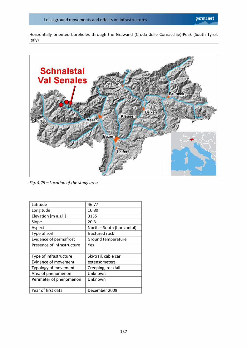
Horizontally oriented boreholes through the Grawand (Croda delle Cornacchie)-Peak (South Tyrol,
Italy)
Fig. 4.29 – Location of the study area
Latitude 46.77
Longitude 10.80
Elevation [m a.s.l.] 3135
Slope 20.3
Aspect North – South (horizontal)
Type of soil fractured rock
Evidence of permafrost Ground temperature
Presence of infrastructure Yes
Type of infrastructure Ski-trail, cable car
Evidence of movement extensometers
Typology of movement Creeping, rockfall
Area of phenomenon Unknown
Perimeter of phenomenon Unknown
Year of first data December 2009
PermaNET – Hazards related to permafrost
138
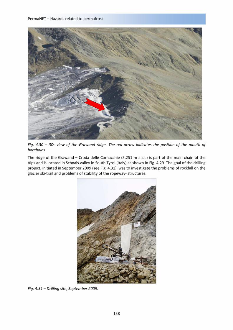
Fig. 4.30 – 3D- view of the Grawand ridge. The red arrow indicates the position of the mouth of
boreholes
The ridge of the Grawand – Croda delle Cornacchie (3.251 m a.s.l.) is part of the main chain of the
Alps and is located in Schnals valley in South Tyrol (Italy) as shown in Fig. 4.29. The goal of the drilling
project, initiated in September 2009 (see Fig. 4.31), was to investigate the problems of rockfall on the
glacier ski-trail and problems of stability of the ropeway- structures.
Fig. 4.31 – Drilling site, September 2009.
Local ground movements and effects on infrastructures
139
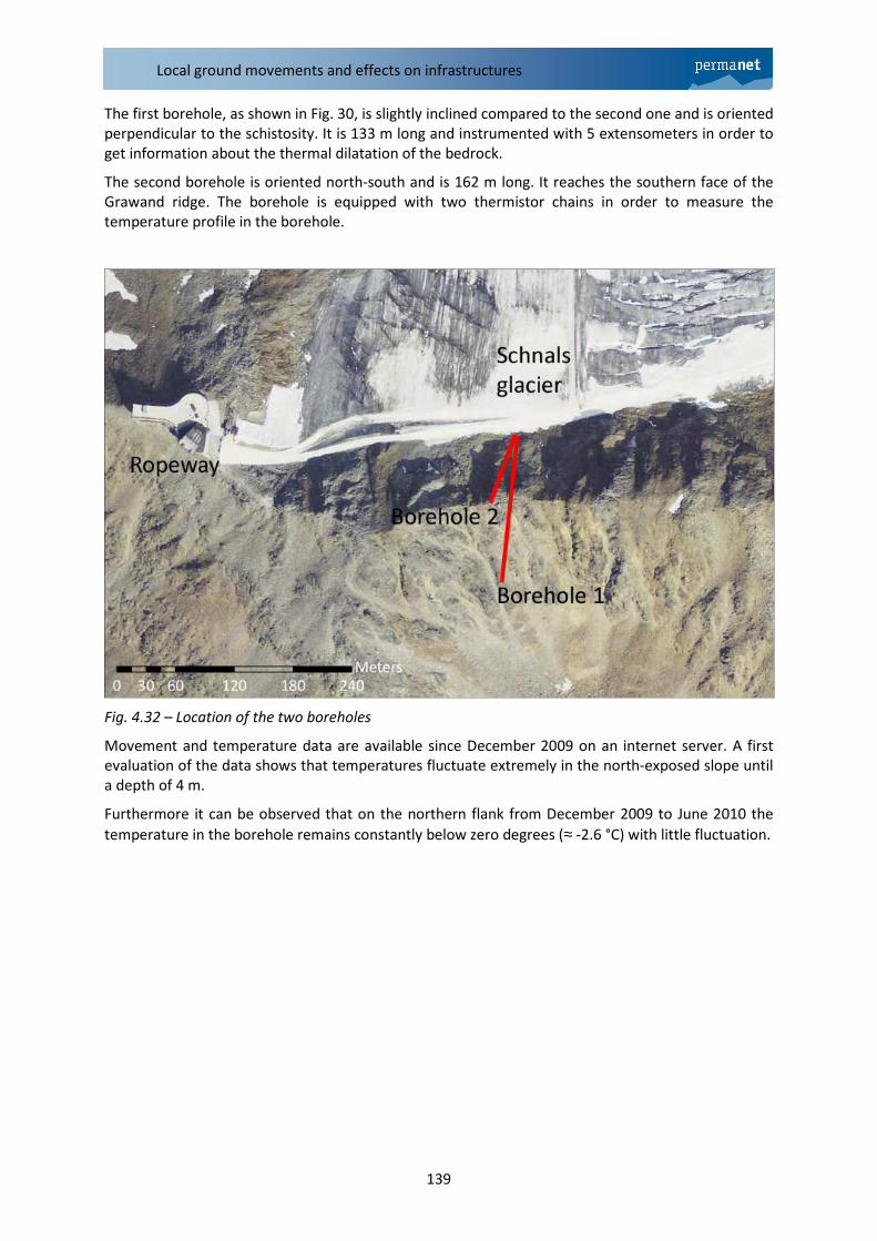
The first borehole, as shown in Fig. 30, is slightly inclined compared to the second one and is oriented
perpendicular to the schistosity. It is 133 m long and instrumented with 5 extensometers in order to
get information about the thermal dilatation of the bedrock.
The second borehole is oriented north-south and is 162 m long. It reaches the southern face of the
Grawand ridge. The borehole is equipped with two thermistor chains in order to measure the
temperature profile in the borehole.
Fig. 4.32 – Location of the two boreholes
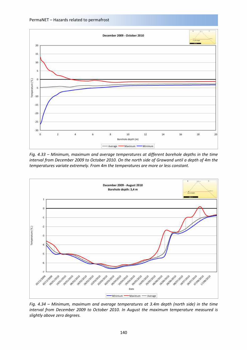
Movement and temperature data are available since December 2009 on an internet server. A first
evaluation of the data shows that temperatures fluctuate extremely in the north-exposed slope until
a depth of 4 m.
Furthermore it can be observed that on the northern flank from December 2009 to June 2010 the
temperature in the borehole remains constantly below zero degrees (≈ -2.6 °C) with little fluctuation.
PermaNET – Hazards related to permafrost
140
Fig. 4.33 – Minimum, maximum and average temperatures at different borehole depths in the time
interval from December 2009 to October 2010. On the north side of Grawand until a depth of 4m the
temperatures variate extremely. From 4m the temperatures are more or less constant.
Fig. 4.34 – Minimum, maximum and average temperatures at 3.4m depth (north side) in the time
interval from December 2009 to October 2010. In August the maximum temperature measured is
slightly above zero degrees.
Local ground movements and effects on infrastructures
141
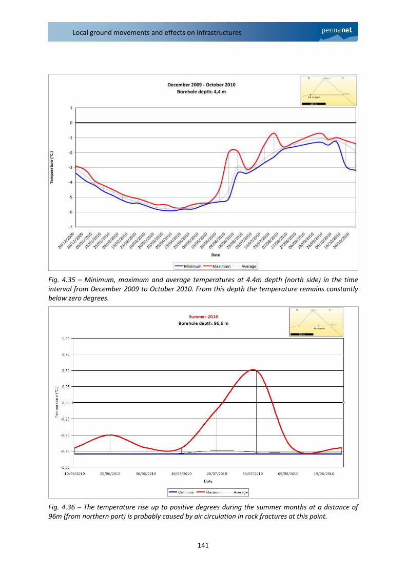
Fig. 4.35 – Minimum, maximum and average temperatures at 4.4m depth (north side) in the time
interval from December 2009 to October 2010. From this depth the temperature remains constantly
below zero degrees.
Fig. 4.36 – The temperature rise up to positive degrees during the summer months at a distance of
96m (from northern port) is probably caused by air circulation in rock fractures at this point.
PermaNET – Hazards related to permafrost
142
At different distances from the northern port, especially at 42 m and 96 m, during the summer
months the temperatures rise up to positive degrees. We speculate that in these zones warm air
from the surface is circulating within an intensely fractured rock mass.
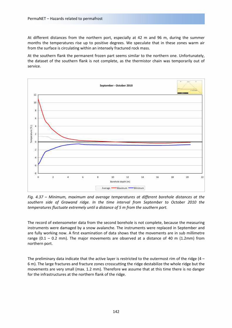
At the southern flank the permanent frozen part seems similar to the northern one. Unfortunately,
the dataset of the southern flank is not complete, as the thermistor chain was temporarily out of
service.
Fig. 4.37 – Minimum, maximum and average temperatures at different borehole distances at the
southern side of Grawand ridge. In the time interval from September to October 2010 the
temperatures fluctuate extremely until a distance of 5 m from the southern port.
The record of extensometer data from the second borehole is not complete, because the measuring
instruments were damaged by a snow avalanche. The instruments were replaced in September and
are fully working now. A first examination of data shows that the movements are in sub millimetre
range (0.1 – 0.2 mm). The major movements are observed at a distance of 40 m (1.2mm) from
northern port.
The preliminary data indicate that the active layer is restricted to the outermost rim of the ridge (4 –
6 m). The large fractures and fracture zones crosscutting the ridge destabilize the whole ridge but the
movements are very small (max. 1.2 mm). Therefore we assume that at this time there is no danger
for the infrastructures at the northern flank of the ridge.
Local ground movements and effects on infrastructures
143
3.4 Switzerland
Snow nets in permafrost at Wisse Schijen (Randa, Canton Valais, Switzerland)
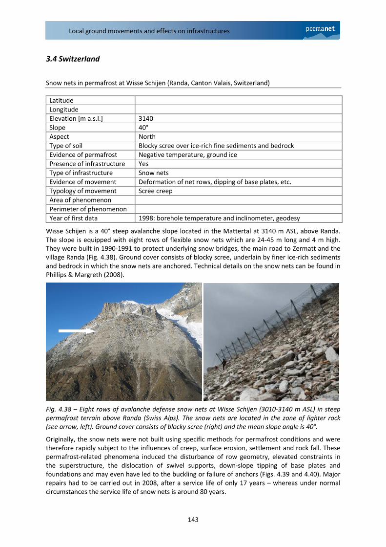
Wisse Schijen is a 40° steep avalanche slope located in the Mattertal at 3140 m ASL, above Randa.
The slope is equipped with eight rows of flexible snow nets which are 24-45 m long and 4 m high.
They were built in 1990-1991 to protect underlying snow bridges, the main road to Zermatt and the
village Randa (Fig. 4.38). Ground cover consists of blocky scree, underlain by finer ice-rich sediments
and bedrock in which the snow nets are anchored. Technical details on the snow nets can be found in
Phillips & Margreth (2008).
Fig. 4.38 – Eight rows of avalanche defense snow nets at Wisse Schijen (3010-3140 m ASL) in steep
permafrost terrain above Randa (Swiss Alps). The snow nets are located in the zone of lighter rock
(see arrow, left). Ground cover consists of blocky scree (right) and the mean slope angle is 40°.
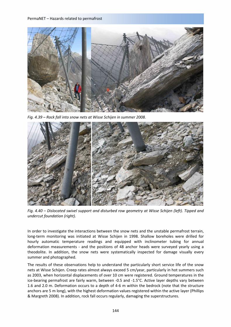
Originally, the snow nets were not built using specific methods for permafrost conditions and were
therefore rapidly subject to the influences of creep, surface erosion, settlement and rock fall. These
permafrost-related phenomena induced the disturbance of row geometry, elevated constraints in
the superstructure, the dislocation of swivel supports, down-slope tipping of base plates and
foundations and may even have led to the buckling or failure of anchors (Figs. 4.39 and 4.40). Major
repairs had to be carried out in 2008, after a service life of only 17 years – whereas under normal
circumstances the service life of snow nets is around 80 years.
Latitude
Longitude
Elevation [m a.s.l.] 3140
Slope 40°
Aspect North
Type of soil Blocky scree over ice-rich fine sediments and bedrock
Evidence of permafrost Negative temperature, ground ice
Presence of infrastructure Yes
Type of infrastructure Snow nets
Evidence of movement Deformation of net rows, dipping of base plates, etc.
Typology of movement Scree creep
Area of phenomenon
Perimeter of phenomenon
Year of first data 1998: borehole temperature and inclinometer, geodesy
PermaNET – Hazards related to permafrost
144
Fig. 4.39 – Rock fall into snow nets at Wisse Schijen in summer 2008.
Fig. 4.40 – Dislocated swivel support and disturbed row geometry at Wisse Schijen (left). Tipped and
undercut foundation (right).
In order to investigate the interactions between the snow nets and the unstable permafrost terrain,
long-term monitoring was initiated at Wisse Schijen in 1998. Shallow boreholes were drilled for
hourly automatic temperature readings and equipped with inclinometer tubing for annual
deformation measurements - and the positions of 48 anchor heads were surveyed yearly using a
theodolite. In addition, the snow nets were systematically inspected for damage visually every
summer and photographed.
The results of these observations help to understand the particularly short service life of the snow
nets at Wisse Schijen. Creep rates almost always exceed 5 cm/year, particularly in hot summers such
as 2003, when horizontal displacements of over 10 cm were registered. Ground temperatures in the
ice-bearing permafrost are fairly warm, between -0.5 and -1.5°C. Active layer depths vary between
1.6 and 2.0 m. Deformation occurs to a depth of 4-6 m within the bedrock (note that the structure
anchors are 5 m long), with the highest deformation values registered within the active layer (Phillips
& Margreth 2008). In addition, rock fall occurs regularly, damaging the superstructures.
Local ground movements and effects on infrastructures
145
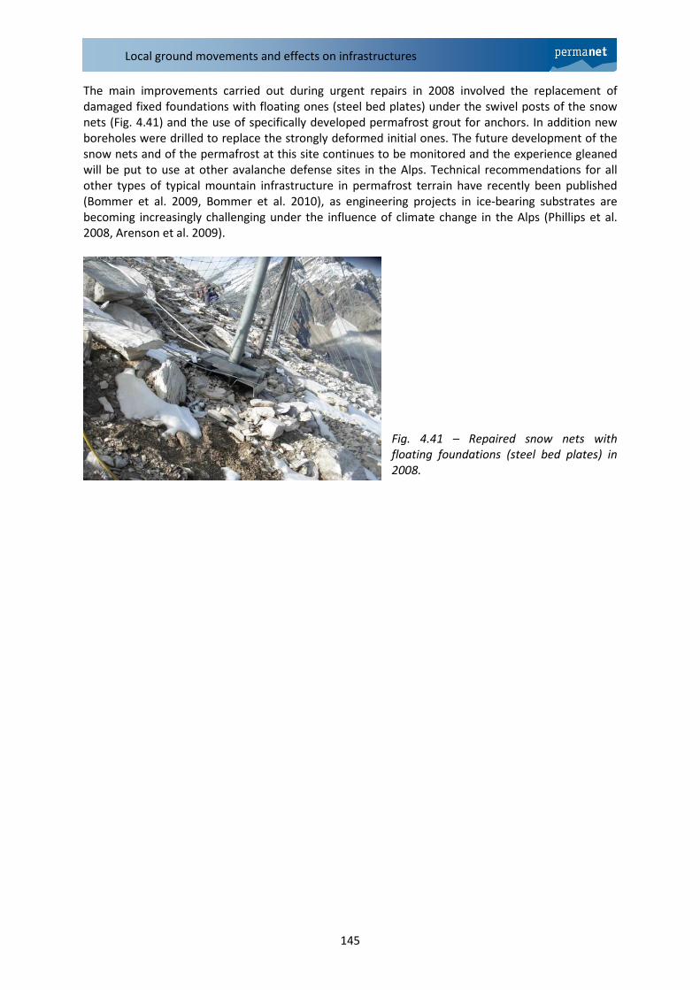
The main improvements carried out during urgent repairs in 2008 involved the replacement of
damaged fixed foundations with floating ones (steel bed plates) under the swivel posts of the snow
nets (Fig. 4.41) and the use of specifically developed permafrost grout for anchors. In addition new
boreholes were drilled to replace the strongly deformed initial ones. The future development of the
snow nets and of the permafrost at this site continues to be monitored and the experience gleaned
will be put to use at other avalanche defense sites in the Alps. Technical recommendations for all
other types of typical mountain infrastructure in permafrost terrain have recently been published
(Bommer et al. 2009, Bommer et al. 2010), as engineering projects in ice-bearing substrates are
becoming increasingly challenging under the influence of climate change in the Alps (Phillips et al.
2008, Arenson et al. 2009).
Fig. 4.41 – Repaired snow nets with
floating foundations (steel bed plates) in
2008.
PermaNET – Hazards related to permafrost
146
4. References
Arenson L.U., Phillips M., Springman S. (2009): Geotechnical considerations and technical solutions
for infrastructure in mountain permafrost. In: M.I. Krugger & H.P. Stern (Eds), New
Permafrost and Glacier Research. Nova Publishers, pp. 3-50.
Bommer C., Phillips M., Arenson L.U. (2010): Practical recommendations for planning, constructing
and maintaining infrastructure in mountain permafrost. Permafrost and Periglacial Processes,
21: 97-104.
Bommer C., Phillips M., Keusen H.-R., Teysseire P. (2009). Bauen im Permafrost: Ein Leitfaden für die
Praxis (Construire sur le pergélisol: guide pratique). Birmensdorf, Eidg. Forschungsanstalt für
Wald, Schnee und Landschaft WSL. 126 p. www.wsl.ch/publikationen/pdf/9819.pdf
Duca S. (2009). Analisi delle problematiche geotecniche relative alla presenza di permafrost in
ambiente alpino. Tesi di laurea specialistica, Politecnico di Torino.
Exner Ch., 1964. Erläuterungen zur geologischen Karte der Sonnblickgruppe 1:50.000 – Geol. B.-A.
168 S., Wien 1964.
Fischer L., Kääb A., Huggel C. & Noetzli J. (2006) - Geology, glacier retreat and permafrost
degradation as controlling factors of slope instabilities in a high-mountain rock wall: the
Monte Rosa east face, Nat. Hazards Earth Syst. Sci., 6; pp. 761÷772
Gruber S., Hoelzle M. & Haeberli W. (2004) - Rock-wall temperature in the Alps: modeling their
topographic distribution and regional differences, Permafrost and Periglacial Processes, 15;
pp. 299÷307
Haeberli and Epifani (1986) – Mapping the distribution of buried glacier ice. An example from Lago
delle Locce, Monte Rosa, Itialian Alps – Annals of Glaciology, 8, 77-81
Harris C., Vonder Mühll C., Isaksen K., Haeberli W., Sollid J.L., King L., Holmlund P., Dramis F.,
Gugliemin M. & Palacios D. (2003) - Warming permafrost in European mountains, Global and
Planetary Change, 39; pp. 215÷225
Margreth S. (2007): Defense structures in avalanche starting zones. Technical guideline as an aid to
enforcement. Environment in Practice no. 0704. Federal Office for the Environment, Bern;
WSL Institute for Snow and Avalanche Research SLF, Davos. 134 pp.
http://www.bafu.admin.ch/publikationen/publikation/00041/index.html?lang=de
Mortara G. & Tamburini A. [Eds.] (2009) – Il ghiacciaio del Belvedere e l’emergenza del lago effimero,
Regione Piemonte e SMS, Torino; pp. 190
Occhiena C., Pirulli M., Arattano M., Chiarle M., Mortara G., Scavia C. & Succio M. (2008). Analisi
dell’attività microsismica di versanti rocciosi instabili: il sistema di monitoraggio del monte
Cervino. Incontro Annuale dei Ricercatori di Geotecnica 2008 - IARG 2008, Catania 15-
17/09/2008
Phillips M. (2006): Avalanche defence strategies and monitoring of two sites in mountain permafrost
terrain, Pontresina, Eastern Swiss Alps. Natural Hazards, 39: 353-379.
Phillips et al. (2008): Monitoring and reconstruction of a chairlift midway station in creeping
permafrost terrain, Grächen, Swiss Alps. Cold Regions Science and Technology, 47 (1-2): 32-
42.
Phillips M. & Margreth S. (2008): Effects of ground temperature and slope deformation on the
service life of snow-supporting structures in mountain permafrost: Wisse Schijen, Randa,

Local ground movements and effects on infrastructures
147
Swiss Alps. In: D.L. Kane & K.M. Hinkel (Eds), 9th
International Conference on Permafrost.
Institute of Northern Engineering, University of Alaska Fairbanks, Alaska, pp. 1417-1422.
Version 5 – 23.12.2011 – GST-PAT + P. Schoeneich