Penrith Lakes Schemeadmin.penrithlakes.com.au › content › 2015 › 03 › Penrith... · Making...
231
Penrith Lakes Scheme Conservation Management Plan Report prepared for Penrith Lakes Development Corporation September 2010
Transcript of Penrith Lakes Schemeadmin.penrithlakes.com.au › content › 2015 › 03 › Penrith... · Making...

Penrith Lakes Scheme Conservation Management Plan
Report prepared for Penrith Lakes Development Corporation September 2010

Report Register
The following report register documents the development and issue of the report entitled Penrith Lakes Scheme—Conservation Management Plan, undertaken by Godden Mackay Logan Pty Ltd in accordance with its quality management system. Godden Mackay Logan operates under a quality management system which has been certified as complying with the Australian/New Zealand Standard for quality management systems AS/NZS ISO 9001:2008.
Job No. Issue No. Notes/Description Issue Date
07-0411 1 Draft report July 2008
07-0411 2 Draft report December 2009
07-0411 3 Draft report February 2010
07-0411 4 Final report July 2010
07-0411 5 Final Report (September 2010, reformatted November 2010) November 2010
Copyright Historical sources and reference material used in the preparation of this report are acknowledged and referenced at the end of each section and/or in figure captions. Reasonable effort has been made to identify, contact, acknowledge and obtain permission to use material from the relevant copyright owners.
Unless otherwise specified or agreed, copyright in this report vests in Godden Mackay Logan Pty Ltd (‘GML’) and in the owners of any pre-existing historic source or reference material.
Moral Rights GML asserts its Moral Rights in this work, unless otherwise acknowledged, in accordance with the (Commonwealth) Copyright (Moral Rights) Amendment Act 2000. GML’s moral rights include the attribution of authorship, the right not to have the work falsely attributed and the right to integrity of authorship.
Right to Use GML grants to the client for this project (and the client’s successors in title) an irrevocable royalty-free right to reproduce or use the material from this report, except where such use infringes the copyright and/or Moral Rights of GML or third parties.
Penrith Lakes Scheme—Conservation Management Plan, September 2010
Contents Page
1.0 Introduction........................................................................................................................................ 1 1.1 Background ...................................................................................................................................... 1 1.2 Why is this CMP Needed? ............................................................................................................... 1 1.3 When to use this CMP? ................................................................................................................... 1 1.4 How to use this CMP........................................................................................................................ 2 1.5 Study Area........................................................................................................................................ 4 1.6 Statutory Listings.............................................................................................................................. 5
1.6.1 Sydney Regional Environmental Plan 11.................................................................................. 5 1.6.2 Penrith Local Environmental Plan 1991 (Environmental Heritage Conservation)..................... 6 1.6.3 NSW State Heritage Register.................................................................................................... 7
1.7 Non-statutory Listings....................................................................................................................... 7 1.7.1 National Trust Register (NSW).................................................................................................. 7 1.7.2 Register of the National Estate.................................................................................................. 7 1.7.3 The Deed of Agreement 1987................................................................................................... 8
1.8 Previous Reports.............................................................................................................................. 8 1.9 Methodology and Terminology......................................................................................................... 8 1.10 Limitations ...................................................................................................................................... 9 1.11 Authorship .................................................................................................................................... 10 1.12 Acknowledgements...................................................................................................................... 10 1.13 Endnotes ...................................................................................................................................... 12
2.0 Historical Context ............................................................................................................................ 13 2.1 Introduction..................................................................................................................................... 13 2.2 Occupation, Contact and Conflict................................................................................................... 14 2.3 Living at Castlereagh...................................................................................................................... 21 2.4 Shaping the Land ........................................................................................................................... 25 2.5 Seeing and Representing the Land ............................................................................................... 35 2.6 New South Wales Historic Themes ............................................................................................... 41 2.7 Chronological Timeline................................................................................................................... 43 2.8 Endnotes ........................................................................................................................................ 44
3.0 Physical Description and Analysis................................................................................................ 47 3.1 Introduction..................................................................................................................................... 47 3.2 Site Analysis................................................................................................................................... 47
3.2.1 Landscape and Setting............................................................................................................ 47 3.2.2 Plantings .................................................................................................................................. 48 3.2.3 Roads ...................................................................................................................................... 49 3.2.4 Fencelines ............................................................................................................................... 50 3.2.5 Built Elements.......................................................................................................................... 50
3.3 Cultural Landscape of the Penrith Lakes Scheme......................................................................... 53 3.4 Views.............................................................................................................................................. 53 3.5 Condition and Integrity ................................................................................................................... 54 3.6 Archaeological Features ................................................................................................................ 55 3.7 Endnotes ........................................................................................................................................ 66

Penrith Lakes Scheme—Conservation Management Plan, September 2010
4.0 Assessment of Heritage Significance........................................................................................... 67 4.1 Introduction .................................................................................................................................... 67 4.2 New South Wales Heritage Assessment Guidelines..................................................................... 67
4.2.1 Introduction.............................................................................................................................. 67 4.3 Heritage Assessment of Penrith Lakes.......................................................................................... 68
4.3.1 Criterion A (Historic: Evolution) ............................................................................................... 68 4.3.2 Criterion B (Historic: Association)............................................................................................ 69 4.3.3 Criterion C (Aesthetic Significance)......................................................................................... 70 4.3.4 Criterion D (Social Significance).............................................................................................. 70 4.3.5 Criterion E (Research Potential).............................................................................................. 71 4.3.6 Criterion F (Rarity) ................................................................................................................... 72 4.3.7 Criterion G (Representativeness)............................................................................................ 73 4.3.8 Aboriginal Archaeology ........................................................................................................... 73
4.4 Statement of Significance .............................................................................................................. 74
5.0 Key Considerations......................................................................................................................... 77 5.1 Introduction .................................................................................................................................... 77
5.1.1 Guiding Principles.................................................................................................................... 77 5.2 Key Considerations Arising from Significance............................................................................... 78 5.3 Key Considerations Arising from Condition and Integrity .............................................................. 79 5.4 Owner Requirements and Future Uses......................................................................................... 80 5.5 Deed of Agreement and Conditions of Development Consent...................................................... 81 5.6 Statutory Requirements ................................................................................................................. 81
5.6.1 Environmental Protection and Biodiversity Conservation Act 1999........................................ 82 5.6.2 Disability Discrimination Act 1992 ........................................................................................... 83 5.6.3 New South Wales Threatened Species Conservation Act 1995 ............................................ 83 5.6.4 Heritage Act 1977 (NSW)........................................................................................................ 84 5.6.5 Environmental Planning and Assessment Act 1979 ............................................................... 85 5.6.6 State Environmental Planning Policy (Major Projects) 2005................................................... 86 5.6.7 State Environmental Planning Policy No. 55—Remediation of Land ..................................... 86 5.6.8 Sydney Regional Environmental Plan 11................................................................................ 86 5.6.9 The National Parks and Wildlife Act, 1974.............................................................................. 87 5.6.10 Catchment Management Authorities Act 2003 ..................................................................... 87 5.6.11 The New South Wales Noxious Weeds Act 1993................................................................. 88 5.6.12 Native Vegetation Act 2003................................................................................................... 88 5.6.13 Penrith Local Environmental Plan 1991 (Environmental Heritage Conservation) ................ 88 5.6.14 The Building Code of Australia (BCA)................................................................................... 89 5.6.15 Coroners Act 1980 ................................................................................................................ 89 5.6.16 Public Health Act 1991.......................................................................................................... 89 5.6.17 The Conversion of Cemeteries Act 1974 .............................................................................. 89
5.7 Development Guidelines................................................................................................................ 90 5.7.1 Curtilage and Setting............................................................................................................... 90 5.7.2 New Development................................................................................................................... 91 5.7.3 Development Guidelines ......................................................................................................... 91
5.8 Endnotes........................................................................................................................................ 96

Penrith Lakes Scheme—Conservation Management Plan, September 2010
6.0 Conservation Policies ..................................................................................................................... 97 6.1 Introduction..................................................................................................................................... 97 6.2 Adoption, Endorsement and Review of the Conservation Management Plan............................... 97 6.3 Overarching Conservation and Management Policies................................................................... 98 6.4 Research, Listings and Documentation ....................................................................................... 102 6.5 Qualifications, Experience and Abilities ....................................................................................... 104 6.6 Community Engagement and Interpretation ................................................................................ 105 6.7 The Archaeological Resource...................................................................................................... 108 6.8 Landscape and Setting ................................................................................................................ 110 6.9 Physical Intervention, Including Maintenance.............................................................................. 115 6.10 Heritage Conservation and New Development.......................................................................... 118
6.10.1 Designing for New Uses and Development ........................................................................ 118
7.0 Individual Site Inventory Forms................................................................................................... 121 7.1 Introduction................................................................................................................................... 121
8.0 Bibliography................................................................................................................................... 189
9.0 Appendices .................................................................................................................................... 193 Appendix A
Sydney Regional Environmental Plan No.11 (Penrith Lakes), Approved Penrith Lakes Structure Plan, 1998
Appendix B State Heritage Register (SHR) citation for the Upper Castlereagh School and Residence.
Appendix C National Trust Listing Cards for sites within the Scheme Area.
Appendix D Register of the National Estate (RNE) citations for sites, elements and areas within the Scheme area.

Penrith Lakes Scheme—Conservation Management Plan, September 2010

Penrith Lakes Scheme—Conservation Management Plan, September 2010 1
1.0 Introduction
1.1 Background This Conservation Management Plan (CMP) has been prepared by Godden Mackay Logan (GML) for the Penrith Lakes Development Corporation (PLDC). The CMP strives to balance conservation management of significant heritage within the context of sand and gravel mining, proposed land remediation, development, public recreation, access and enjoyment.
This CMP is intended to guide the management and conservation of heritage within the Penrith Lakes Scheme area (‘the Scheme area’) (see Figure 1.2). It provides a framework for ongoing conservation and management of heritage within the area, as well as general and specific policy recommendations based on the assessment of the area’s cultural significance, its condition, the integrity of the physical fabric and other relevant requirements.
The aim of this CMP is to conserve the significance of heritage items within the Penrith Lakes Scheme area and provide for its long-term security, viability and conservation.
1.2 Why is this CMP Needed? This CMP provides a robust rationale to guide decision-making for the management and conservation of heritage within the Scheme area. This CMP relies upon and synthesises a considerable archive of previous research that has been commissioned by PLDC over many years.
This CMP is necessary to support a flexible, positive and proactive approach to heritage conservation within the Scheme area.
1.3 When to use this CMP? This CMP should be used by those responsible for the management and conservation of the Penrith Lakes Scheme area to inform decisions about the day-to-day and ongoing management of its heritage. The following table provides an indicative list of occasions when the CMP should be consulted.
Task Description
Masterplanning Consult the CMP to identify areas that have a higher tolerance for change and to find out what are the most appropriate settings for development. Ask the question, ‘Does the proposed development require modification to ensure significance is conserved?’
Making changes—new buildings and landscaping Prior to making changes, be sure to consult the CMP to understand what the risks to heritage significance are. Consider the constraints and opportunities to work out what’s possible. The CMP will help you identify changes which have the potential to impact on the heritage significance of the site.
Upgrading services Check the CMP to find out if there are any special requirements for contractors. For example, the CMP may state that they must have the necessary skills and experience as well as an appreciation and understanding of heritage buildings. Workers may need to be made familiar with special issues on site and induction sessions maybe necessary.
When considering future options When considering a possible change in use or function of a site (or element thereof), use this CMP to help guide decision-
Penrith Lakes Scheme—Conservation Management Plan, September 2010 2
Task Description making and identify the appropriate course of action and process.
Undertaking maintenance work, including contaminated building remediation
Ensure that contractors or maintenance workers understand the importance of heritage fabric and protect significant fabric during works.
Undertaking research When considering undertaking research, consult the CMP to assist in the identification of potential areas of research.
Preparing a request for tenders or engaging contractors Before preparing tender documents or engaging contractors, consult the CMP. Define the project brief with reference to the relevant sections. Ensure that you know what skills contractors need to work on heritage buildings.
Ordering new building materials Before purchasing new materials for heritage buildings check the CMP to ensure that there are no special requirements. For example, a particular type or brand of fabric may be necessary, or you may need to match ‘like with like’.
Disposal Consider the consequences of disposal before acting. Consult the CMP to ascertain whether the disposal of all or part of a place would have an adverse impact on heritage significance.
1.4 How to use this CMP This CMP is intended to guide decision-making for heritage within the Penrith Lakes Scheme. It covers the Scheme area in its entirety and individual heritage sites specifically. Each section of the report provides information and assistance to ensure decisions and actions are informed by sound heritage management and conservation principles and practice.
The flow chart below provides an overview of the CMP contents. It outlines each section and explains its purpose and best use.

Penrith Lakes Scheme—Conservation Management Plan, September 2010 3
Sections 1.0 and 2.0 Introduction and History
Use this section to understand the background to the report and the Scheme area’s history
Statutory roles and responsibilities
Section 3.0 Physical Description and Analysis
Understand the condition and integrity of the site and its features
Section 4.0 Heritage Significance Assessment
Understand all the heritage values and importance of the site Learn why the place needs to be conserved
Section 6.0 Conservation Policies
Use this section to assess actions and guide decision-making Learn what to do and what not to do
Section 7.0 Individual Heritage Site Inventory Forms
Find out about each heritage site Learn why each site is important
Get practical advice about how to manage and protect significant values
Section 5.0 Key Considerations
Use this section to understand what opportunities there are Find out how to avoid actions with potential to impact on heritage
significance

Penrith Lakes Scheme—Conservation Management Plan, September 2010 4
1.5 Study Area The study area is the Penrith Lakes Scheme, located in Castlereagh, at the northwestern edge of the Cumberland Plain, 54 kilometres west of Sydney (see Figure 1.1). It is located in the City of Penrith Local Government Area, in the County of Cumberland.
The Scheme area comprises 1935 hectares (see Figure 1.2).1 The Scheme area is bounded by the Nepean River to the south and west. Beyond the Nepean River to the west lies the Blue Mountains escarpment, and to the south is the urban area of Penrith. To the northeast is the Castlereagh (or Cranebrook) Escarpment.
As a result of early European farming practices and more recent large-scale quarrying for sand and gravel, much of the study area has been cleared. The Scheme area remains an operational mining facility at this time. A number of sites of European heritage significance have been retained within the Scheme area.
Not all the heritage sites situated with the Scheme area are owned or managed by PLDC. The following table includes a list of sites and items that are within the Penrith Lakes Scheme. The current ownership for each heritage site is indicated
Heritage Sites within the Scheme Area Current Ownership
Mass concrete house (43 Smith Road, also known as Howell’s House)
PLDC
Landers Inn and stables PLDC
Puddledock (slab cottage) PLDC
Hadley Park PLDC
Jackson’s Ford PLDC
Gravel plant (ruins) PLDC
McCarthy’s cemetery PLDC
Long’s house PLDC
Mass concrete house ruins (ruins) PLDC
Fulton’s Parsonage (ruins) PLDC
Nepean Park Private ownership
Upper Castlereagh schoolhouse and schoolmasters residence NSW State Government
The Poplars NSW State Government
Methodist church and hall Church ownership
Methodist cemetery Church ownership
Lee’s cottage (ruins) Church ownership
Information on individual sites and items can be found in Section 3.0 of this report and in the Section 7.0 individual site inventory forms.

Penrith Lakes Scheme—Conservation Management Plan, September 2010 5
1.6 Statutory Listings Heritage items within the Penrith Lakes Scheme area are listed under a number of planning instruments. Some of the Heritage Items within the Scheme area have dual listing under the Sydney Regional Environmental Plan 11—Penrith Lakes Scheme (SREP 11) and the Penrith Local Environmental Plan 1991 (Environmental Heritage Conservation).
Two separate processes led to the dual listing. Penrith City Council commissioned the preparation of the Penrith Heritage Study which resulted in the gazettal of the Penrith Local Environmental Plan 1991 (Environmental Heritage Conservation). The heritage items listed in the Sydney Regional Environmental Plan 11—Penrith Lakes Scheme were the result of regional environmental studies undertaken by the NSW Department of Planning.
1.6.1 Sydney Regional Environmental Plan 11
The Sydney Regional Environmental Plan 11—Penrith Lakes Scheme (SREP 11), applies to the Castlereagh floodplain adjacent to the Nepean River. The plan provides a framework for the development of regionally significant recreation lakes by the controlled extraction of sand and gravel. Changes to the plan allow the establishment of an international rowing course, reserve land for the relocation of Castlereagh Road, change the design of the lakes scheme and remove provisions concerning the preparation of statements of environmental effects and the provision of development control codes.
The Penrith Lakes Scheme development is implemented under the provisions of the Sydney Regional Environmental Plan 11—Penrith Lakes Scheme (SREP 11). The consent authority for the SREP is the Minister for Planning as the Scheme was identified as a State Significant Development in February 2007 under the State Environmental Planning Policy (State Significant Development) 2005 (SEPP 2005).
In this CMP Appendix A contains the approved structure plan contained in SREP 11—Penrith Lakes Scheme. The SREP 11 also identifies and protects items of environmental heritage. Schedule 3 of the SREP 11 contains the following items of environmental heritage within the Penrith Lakes Scheme:
• Hadley Park (Lots 1 and 2, MPOS (OS) 8807) Parish of Castlereagh, County of Cumberland;
• Nepean Park (part of Portion 48) Parish of Castlereagh, County of Cumberland;
• McCarthy’s Cemetery (part of Portion 82) Parish of Castlereagh, County of Cumberland;
• Upper Castlereagh Methodist church and hall (part of Portion 71) Parish of Castlereagh, County of Cumberland;
• Upper Castlereagh School and residence (part of Portion 54) Parish of Castlereagh, County of Cumberland; and
• Methodist cemetery, (part of Portion 71) Parish of Castlereagh, County of Cumberland.
The State Government has determined to remove REPs from the statutory planning framework in NSW. As of 1 July 2009, in an effort to simplify NSW’s planning system, REPs will be progressively reviewed. SREP 11 has been reviewed is now deemed to be a State Environmental Planning Policy (SEPP).

Penrith Lakes Scheme—Conservation Management Plan, September 2010 6
The consent authority for development within the scheme area, excluding extraction, rehabilitation, lake formation or associated infrastructure, is Penrith City Council.
With regard to the listed items of environmental heritage under the SREP 11, PLDC will not undertake any of the following activities without development consent from Penrith City Council:
(a) demolish, renovate or extend the building or work,
(b) damage or despoil the relic or place, or any part of the relic or place,
(c) excavate any land for the purpose of exposing or removing the relic, or
(d) erect a building on the land on which the building, work or relic is situated, or the land that comprises that place.2
Development consent will not granted without the following assessments being made:
(a) the significance of the item as an item of the environmental heritage,
(b) the extent to which the carrying out of development in accordance with the consent would affect the historic, scientific, cultural, social, archaeological, architectural, natural or aesthetic significance of the item and its site,
(c) whether the setting of the item, and in particular whether any stylistic, horticultural or architectural features of the setting, should be retained, and
(d) whether the item constitutes a danger to the users or occupiers of the item or to the public.3
1.6.2 Penrith Local Environmental Plan 1991 (Environmental Heritage Conservation)
The aim of the Penrith Local Environmental Plan 1991 (Environmental Heritage Conservation) is to conserve and enhance the heritage items and heritage conservation areas identified and listed within the City of Penrith.
The Sydney Regional Environmental Plan 11—Penrith Lakes Scheme prevails over the LEP 1991 in the event of inconsistencies between the two instruments.
Schedule 2 of the Penrith Local Environmental Plan 1991 (Environmental Heritage Conservation) identifies and lists heritage items which include buildings, archaeological sites and landscapes of environmental heritage value.
The following sites within the Penrith Lakes Scheme area are listed as heritage items in the Penrith Local Environmental Plan 1991 (Environmental Heritage Conservation) (LEP 1999):
• ruin of stone stables associated with Landers Inn, part Portion 43, Castlereagh Road (C6) (Landers Inn);
• slab cottage (also known as Puddledock), Lot 1, DP 120872, Castlereagh Road (C7);
• farmhouse, garden planting and natural vegetation, Lot 1, DP 574481, Church Lane (C10);
• ruins of pise house Portion 280, Church Lane (C13);
• site of Fulton’s Church School, Church Street, Portions 287 and 288 (C15);
• McCarthy’s Farm, tree and archaeological remains, Portion 82, McCarthys Lane (CR9); and

Penrith Lakes Scheme—Conservation Management Plan, September 2010 7
• The Poplars; old slab cottage, pise house and garden, Lot 2, DP 229462, Wrights Lane (CR 8).
• UC 4: Upper Castlereagh War Memorial.
The LEP 1991 includes similar heritage provisions to that of the SREP 11. Development consent from Penrith City Council is required for works that may damage, demolish or alter listed heritage items. Development in the vicinity of listed items and within heritage conservation areas is also covered by provisions in the LEP 1991.
Penrith City Council has prepared a Draft Penrith Local Environmental Plan 1998 and draft amendment no 1 Penrith LEP 1991 (Environmental Heritage Conservation). At the time of writing the draft LEP and the draft amendment had not been made by the Minister for Planning.
1.6.3 NSW State Heritage Register
The following site is listed as a heritage item on the NSW State Heritage Register:
• Upper Castlereagh School and residence (listing number 00339).
This Upper Castlereagh School and School Master’s residence is was also the subject of a Permanent Conservation Order under the Heritage Act 1977 (NSW) (‘the Heritage Act’) predating the site’s listing. The full citation of the SHR listing is contained in Appendix B.
The Upper Castlereagh School and School Master’s Residence is owned by the NSW Department of Human Services, Ageing, Disability and Home Care. The property has been declared surplus to the department’s requirements and the State Property Authority has been engaged to manage the property’s disposal.
1.7 Non-statutory Listings
1.7.1 National Trust Register (NSW)
The following sites are classified by the National Trust (NSW):
• Methodist church and cemetery and church hall;
• Nepean Park;
• Hadley Park; and
• McCarthy’s Roman Catholic cemetery.
Full citations of each listing are contained in Appendix C.
1.7.2 Register of the National Estate
The following sites are listed on the Register of the National Estate:
• The Scheme area lies within part of the Castlereagh area, Upper Castlereagh, NSW, Australia (place ID 101338)—comprising floodplain, Upper Castlereagh and the township of Castlereagh.
• Nepean Park (place ID 3118).

Penrith Lakes Scheme—Conservation Management Plan, September 2010 8
• Upper room chapel, hall and cemetery, 1727 Castlereagh Rd, Castlereagh, NSW, Australia (place ID 103815)
Full citations of each listing are contained in Appendix D.
On 1 January 2004, a new national heritage system was established under the Environment Protection and Biodiversity Conservation Act 1999 (EPBC Act). The Register of the National Estate (RNE) will continue as a statutory register until February 2012. During this period the Minister for the Environment, Heritage and the Arts (the Minister) is required to continue considering the RNE when making decisions under the EPBC Act. This transition period allows states, territories, local and the Australian Government to complete the task of transferring places to appropriate heritage registers where necessary.
1.7.3 The Deed of Agreement 1987
In 1987 the NSW State Government and PLDC entered into a formal deed of agreement (the Deed) to implement the Scheme. The Deed specifies processes to be adopted by both parties to achieve a planned extraction of sand and gravel to meet Sydney’s medium term needs and to provide major water orientated facilities for western Sydney. The Deed was amended in 1989 to make provision for the construction of the Sydney International Regatta Centre and Penrith Whitewater Stadium for the 2000 Olympic Games.
Under the Deed, rehabilitation works are to provide significant community benefits, including the preservation of selected heritage sites (no quarrying areas) within the Scheme area. The heritage sites identified in Schedule 12 of the Deed are listed below:
• Hadley Park, Lots 1 and 2, MPS (OS) 8807, Parish of Castlereagh, County of Cumberland (shown as Heritage Item number 1 on the Structure Plan).
• Nepean Park, part Portion 48, Parish of Castlereagh, County of Cumberland (shown as Heritage Item number 2 on the Structure Plan).
• McCarthys Cementery, part Portion 82, Parish of Castlereagh, County of Cumberland (shown as Heritage Item number 4 Methodist Church and Hall on the Structure Plan).
• Upper Castlereagh School and Residence, part Portion 54, Parish of Castlereagh, County of Cumberland to which Permanent Conservation Order No 339 under the Heritage Act 1977 applies (shown as Heritage Item number 5 on the Structure Plan).
• Methodist Cemetery part Portion 71, Parish of Castlereagh, County of Cumberland (shown as Heritage Item number 6 on the Structure Plan).
Actions within the scheme area are also governed by the conditions of consent issued for Development Applications 1 to 4.
1.8 Previous Reports A number of previous reports have been used in the preparation of this CMP. These can be found in Section 8.0 of this report.

Penrith Lakes Scheme—Conservation Management Plan, September 2010 9
1.9 Methodology and Terminology This CMP has been prepared with regard to the methodology outlined in the NSW Heritage Manual guidelines for the preparation of Conservation Management Plans (NSW Department of Urban Affairs and Planning and the Heritage Council of NSW, November 1996, as amended July 2002). It also follows the approach set out in The Conservation Plan, by James Semple Kerr (National Trust of Australia, NSW, fifth edition, 2000) and the guidelines of The Burra Charter: The Australia ICOMOS Charter for Places of Cultural Significance 1999 (the Burra Charter).
The following terminology used in this report is consistent with the NSW Heritage Manual, prepared by the NSW Heritage Office (now the Heritage Branch), Department of Planning.
• Curtilage is the area of land (including land covered by water) surrounding an item or area of heritage significance which is essential for retaining and interpreting its heritage significance.
• Riparian Way is any land which adjoins, directly influences, or is influenced by a body of water.
• Cumberland Plain Woodland is distinct grouping of plants that occur on the clay soils derived from shale on the undulating Cumberland Plain in central New South Wales. The most commonly found trees in the woodland are Grey Box Eucalypts Eucalyptus moluccana, Forest Red Gums Eucalyptus tereticornis, Narrow-Leaved Ironbarks Eucalyptus crebra and Spotted Gum Eucalyptus maculata.
• Sydney Coastal River-Flat Forest is an endangered ecological community found throughout the coastal floodplains of New South Wales. It generally occupies central parts of floodplains where flooding is periodic and soils are rich in silt. Remnants are found on Portion 45 of the Scheme area.
• Cultural Landscape refers to those areas of the landscape which have been significantly modified by human activity.
• Conservation Zones refer to areas of land that have been set aside by PLDC as a non-quarry zones for either cultural and or environmental values. The conservation zones have no legal status, however, some conservation zones include formally listed heritage items.
The preparation of this CMP has included consultation with:
• Members of the Nepean District Historical Archaeology Group (NDHAG);
• Members of the Penrith District Historical Society;
• Associate Professor Carol Liston;
• Dr Louise Steding; and
• PLDC staff.
1.10 Limitations As some heritage sites are presently tenanted, full access was not available within the Penrith Lakes Scheme area.
Penrith Lakes Scheme—Conservation Management Plan, September 2010 10
This CMP does not address Aboriginal cultural heritage in detail and the reader should refer to the Aboriginal Heritage Management Plan by Comber Consultants Pty Ltd. For information regarding natural heritage management and conservation the reader should consult Castlereagh Biodiversity and Natural Heritage Conservation Masterplan: Delivering key aspects of the Urban Ecology Vision, prepared by Total Catchment Management Services Pty Ltd (TCM) for PLDC and for a detailed assessment of the archaeological resource of the site refer to the Penrith Lakes Archaeological Management Plan (in preparation) by GML. For information regarding heritage landscape management readers should refer to the Penrith Lakes Development Scheme Landscape Heritage Strategy, prepared by Clouston Associates.
The preparation of this CMP has not included a community consultation program. GML staff attended a community meeting in October 2007 at the Penrith Lakes Development Corporation (PLDC) offices to discuss future ownership, management and conservation of McCarthy’s Cemetery.
The community meeting was well attended and included several people from families descended from Castlereagh’s early settlers and representatives from the Nepean District Historical Society and the Nepean District Historical Archaeology Group. The meeting provided an opportunity to meet with many people who have a strong association with Penrith Lakes and canvass some of the issues related to future use and interpretation.
1.11 Authorship This report has been prepared by Sharon Veale, Senior Associate, and Rebecca Thompson, Consultant. Historical analysis was prepared by Mark Dunn, Senior Heritage Consultant. Andrew Sneddon, Senior Heritage Consultant, provided input and reviewed Section 5.0. Input and review has been provided by Sheridan Burke, Partner of GML.
1.12 Acknowledgements A large body of research exists for the Penrith Lakes Scheme area. The preparation of this CMP has been made possible through the gracious and generous assistance of many individuals who have been, and or continue to be, involved in the Scheme area. Their contributions in the form of reports, research, input, expert advice and assistance is gratefully acknowledged by GML.
• John Bates, Penrith Lakes Development Corporation;
• Sandy Booth, Managing Director, Total Catchment Management Services P/L;
• Geoffrey Britton, Environmental Design and Heritage Consultant;
• Dani Drewry, Natural and Cultural Heritage, Penrith Lakes Development Corporation;
• Ken Heldon, descendant of the Landers family for images and family history research;
• Dr Grace Karskens, Senior Lecturer, School of History and Philosophy, University of NSW;
• Dr Siobhan Lavelle, Senior Heritage Officer, Conservation Team, NSW Heritage Office;
• Carol Liston; Associate Professor of History, University of Western Sydney;
• Members of Nepean District Historical Archaeological Group, in particular Ros Wright;

Penrith Lakes Scheme—Conservation Management Plan, September 2010 11
• Members of Nepean District Historical Society;
• Dr Jocelyn Powell, Senior Research Scientist, Total Catchment Management Services P/L; and
• Dr Louise Steding, Stedinger Associates Pty Ltd;
This report does not necessarily represent the opinions of anyone whose assistance is acknowledged above.
Figure 1.1 Area plan showing the location of the Penrith Lakes Scheme, highlighted. (Source: Penrith Lakes Development Corporation)

Penrith Lakes Scheme—Conservation Management Plan, September 2010 12
Figure 1.2 Site plan showing historic portion boundaries, listed heritage sites and conservation zones within the Scheme Area. (Source: Penrith Lakes Development Corporation 2010)
1.13 Endnotes
1 <http://www.penrithlakes.com.au/mainsite/site/html/about_us.htm> 2 <http://www.legislation.nsw.gov.au/viewtop/inforce/epi+018+1986+cd+0+N> accessed 15 March 2010. 3 <http://www.legislation.nsw.gov.au/viewtop/inforce/epi+018+1986+cd+0+N> accessed 15 March 2010.

Penrith Lakes Scheme—Conservation Management Plan, September 2010 13
2.0 Historical Context
2.1 Introduction Over recent years, a national framework of historic themes has been developed by the Australian Heritage Commission, published in 2001. The Australian Historic Themes Framework aims to ‘assist in structuring research and to emphasise the historical values of a place to reverse the prevalence of fabric-based assessment by identifying historical processes that might be used in assessing and interpreting heritage significance’.1 Nine national theme groups were identified, with focused sub themes based on activities. The NSW Heritage Office has also developed state themes that, to a large degree, link with the national framework.2
The following historical analysis is presented in the form of a series of thematic essays. These essays are not intended to be a comprehensive account of the historical development of the area (which is presented in a timeline following the thematic essays), but rather are to be used as tools to inform the conservation management process of the Penrith Lakes Scheme. Analysing the area’s historical development provides the context to, and acts as an aid for, identifying places of heritage significance.
Three broad themes were chosen:
• Occupation, Contact and Conflict—Aboriginal and non-Aboriginal life and inter-relations in the Penrith Lakes area, including British exploration, settlement and townships to 1850. Our Traditional Country—this Country belongs to the Darug, the Mulgoa and Boorooberongal people. They have had a relationship with the land from ancient times which continues into the future. Aboriginal people continue to maintain their connection to country and their culture. This historic message will communicate that despite dispossession and political intervention, Aboriginal people have been actively and continuously engaged in expressing their connection to this land as integral to culture and identity.
• Living at Castlereagh—The development of the settlement of Castlereagh, the schools, churches and cemeteries, and the interaction of the community with each other and the surrounding district from the 1850s onwards, as well as the connection of the people to the place. The Family Tree—tells stories of entangled families and community relationships. Religion and Education—schools, churches and cemeteries demonstrate the spiritual heart of the Castlereagh settlement.
• Shaping the Land—The changing landuses in the area, from Aboriginal landuse to farming, mining and responses to flood as well as current mining and planning developments and the way in which these activities have changed the physical form as well as the understanding of the place. Transforming Place—from Indigenous landscape, to rural landscape, to gravel and sand quarry, to urban ecology. Castlereagh Valley cultural landscape—this place is a rural vernacular landscape with significant heritage values. Mining—following the transformation from farmland to mining landscape, this rich source of sand and gravel has played an important part in building Sydney. Farming—Europeans farmed this land despite the threat of flood from the mighty Nepean.

Penrith Lakes Scheme—Conservation Management Plan, September 2010 14
• Representing and remembering the land—The response of artists and writers to the landscape of the Nepean River and the Castlereagh area and the interaction of the residents and workers with the landscape.
The themes address the relationship and interaction of people with the land from prior to the British arrival, through first Contact, British exploration and exploitation, and up to contemporary use. The use of the Penrith Lakes/Castlereagh area has changed over time, from utilisation by Aboriginal people—members of the Mulgoa and Boorooberongal people—as their home, the exploration parties of the first white visitors, and NSW Corps soldiers, timber cutters, farmers, quarryworkers, mining companies, the artists, settlers and developers. The Castlereagh area has meant many and varied things to each of these diverse groups. Each interaction has layered the landscape and contributed to the way the area is understood and interpreted by others, and the evidence of their occupation. Mourning the loss of special places at Penrith Lakes is a strong aspect of the recent past.
2.2 Occupation, Contact and Conflict The state historical themes (as devised by the Heritage Office, Department of Planning) that are useful for understanding the Penrith Lakes/Castlereagh area as a place of Occupation, Contact and Conflict include:
• Aboriginal cultures and interactions with others;
• Convicts;
• Exploration; and
• Land tenure.
Prior to 1789, the land district around Castlereagh and the Nepean River was the territory of a number of neighboring Aboriginal groups, the Mulgoa, who lived on the Nepean River between present day Mulgoa and Castlereagh, and the Boorooberongal who occupied the land north of Castlereagh to beyond Richmond. Castlereagh was a middle ground, the boundary line between the two groups, both of which belonged to the larger language group of the Darug, which extended from the sea to the mountains, taking in much of the Sydney basin.3
Both groups were hunter-gatherers, relying on the river and the forest land around it for food, shelter and other resources. Their diet included fresh water fish and shellfish, eels, possums (as their main source of protein) and kangaroo which were hunted in organized drives, often involving a number of groups coming together. Edible yams, berries and fruits were also collected, mainly from the rainforest valleys to the west of the River in the mountain foothills.4 As food sources were seasonal, groups moved around their territory to access the resource. In autumn eels were plentiful in the swamps and eddies of the river, while in summer when food was plentiful a number of groups would come to the River to take advantage of it.
The river also provided other resources beside food. The gravel deposits that would later be exploited by miners and quarry workers, were also important to the Aboriginal people of the area. The main source for stone material in the Sydney region was the Nepean-Hawkesbury system and the associated tributaries.5 Chert and silcrete were used for small tool manufacture, such as scrapers, while the profusion of basalt pebbles made the area ideal for making axe heads and chisels. The Mulgoa who made these tools traded them for goods with other Aboriginal people

Penrith Lakes Scheme—Conservation Management Plan, September 2010 15
throughout NSW. Archaeological sites found throughout the Penrith Lakes area and the surrounding foothills of the Nepean Valley offer clear evidence of the Aboriginal occupation of the region.
Although the British had no direct contact with the Castlereagh until 1789, their influence preceded them. By the time Tench and others ‘discovered’ the area, the local Aboriginal population had been disrupted by small pox, or similar disease, which had spread throughout the entire Sydney Aboriginal population from early 1789, decimating each group that it reached. In some cases it was reported that all members of a particular group had died from the disease. The marks of the pox were evident on the faces of the survivors that Tench and others encountered in the Castlereagh district.6
Initial contact on the Nepean was reported as being reasonably friendly, however, by 1794-95 the relationship had soured with open conflict between settlers and Aborigines around Richmond and Windsor. Colonel Paterson ordered a detachment of New South Wales Corps to the area in 1795 to subdue the Aboriginal population. The problems had arisen inevitably as the two cultures clashed over the same resources. As traditional Aboriginal foods became scarce tensions grew, with settlers firing on and killing Aborigines who came into the new crop fields (often planted over the source of yams and other tubers that the Aboriginal people had traditionally relied on) to take food for themselves. Between 1800 and 1816 clashes between settlers and Aboriginal people along the Nepean, the Hawkesbury and surrounding districts grew in intensity, with both sides engaged in running battles and ambushes.7 One such encounter was documented in the Sydney Gazette in May 1805, in which settlers from the Green Hills (Windsor) traveled south to the Nepean to pursue an Aboriginal people, of whom seven or eight were subsequently shot. The pursuers had equipped themselves with a boat, to enable them to follow and cross the river where necessary.8 Governor Macquarie eventually stationed a military detachment on the Nepean at Penrith in May 1816, after which the attacks diminished. By this time however, the numbers of Aboriginal people in the region had been catastrophically diminished through the combination of disease, dislocation from their land and open conflict with settlers. As with other areas in Sydney, those who remained in the area were often a mix of local groups, such as survivors of the Mulgoa and other Darug people who had left or been forced from their own country.
Despite the devastation and dislocation that followed as settlers moved in and occupied land, Aboriginal people of the Castlereagh area, although weakened, did not disappear. Yarramundi, (c1760–1818) was an important local Aboriginal man and member of the Boorooberongal group. He, and his father Gomeberri, were Koradji, or medicine men. Yarramundi had provided medical assistance to one of Captian Watkins Tench’s party when they were exploring the Hawkesbury District in 1791 (in Tench spelt Yellomundee). He also met with Governor Phillip on 14th April 1791 and presented the Governor with a gift of two stone axes. He was given the title of ‘Chief of the Richmond tribe’ by the British settlers. His daughter, Maria Locke (1805-1878) was the first girl to be placed in the care of the Native Institution at Parramatta when it opened in 1815 and was the first Aboriginal women to legally marry a European man. Her brother, Colebee, received the first land grant made to an Aboriginal man. Colebee assisted William Cox when he surveyed the route across the Blue Mountains.
The occupation of the area by Europeans from the early 1800s resulted in the serious disruption of the traditional lifestyles of the Mulgoa and Boorooberongal people, breaking the traditional territorial boundaries and isolating previous areas of food gathering and shelter. The 1828 census recorded

Penrith Lakes Scheme—Conservation Management Plan, September 2010 16
156 Aboriginal people living in the Penrith area, consisting of 38 people from the Nepean, 15 from the Mulgoa, 73 from the Richmond and 30 from the Booroogorang.
By 1840 there were less than 300 Darug recorded in the Sydney region.9 However, Aboriginal people were still in the area in the 1850s, fishing from the river and camping in the remnant forest areas.10 Their traditional life, including camping areas had though been largely swept away, and Aboriginal camps were now located on the fringes of the white settlement, which themselves had most often been built on the best land available and the site of previous Aboriginal encampments.
Despite much historical writing suggesting that it was inevitable that Aboriginal people would soon die out, they endured. In the Nepean, ‘Black Nellie’ (Nah Doongh) was referred to as the ‘last of the Nepean Tribe’.11 In the 1880s Nah Doongh remembered her fear, the chaos and ensuing action when white people arrived.
‘No houses 'tall. I member first White come here—all Blacks den, no houses, all gunyahs—ev'ybody fight, black gins cry, black men shout and get boomerangs an' tings like for big corroboree. Oh lor'—I frightened—get in bush next memurrer [next to my mother]’—Nah Doongh ‘Black Nellie’ circa 1886. 12
The evidence of Aboriginal occupation of the Castlereagh area before the arrival of Europeans has been studied since the turn of the twentieth century. Recent archaeological projects have recorded numerous occupation and tool making sites along the banks of the Nepean and its tributaries. Many of the sites are located within 500 meters of the river bank, giving some insight into the importance of the river in the lives of the Mulgoa and Boorooberongal people.13 Many of the campsites that have been identified in recent archaeological surveys have been on the terraces that run parallel to the river. The camp site locations indicate the detailed understanding of the river cycle that Aboriginal people had and their ability to utilise riverine and terrestrial resources opportunistically.
Although the first settlers had visited the area around what was to be Castlereagh as early as 1789 when Watkin Tench reached the shores of the Nepean River, first settlement did not begin officially until 1803-1804. There may have been earlier unofficial settlement or claims made on land around Castlereagh, although most settlers were then recorded to be concentrated north around Windsor and Richmond. In this year (1803) land grants were laid out between the banks of the Nepean River, and a track heading north towards Green Hills (Windsor) and Richmond later to be known as Castlereagh Road (see Figure 2.1). The grants appeared to have been surveyed prior to their occupation, with blocks running in parallel lines back from the River, apparently in response to the unruly and haphazard nature of land grants further north around Green Hills, which had been first occupied in 1794.14 The lessons learnt from Green Hills were also extended to selecting the type of settler given land at Castlereagh. Whereas at Green Hills many of the grantees were ex-convicts who had settled themselves, those chosen for Castlereagh were a mix of emancipists, veteran soldiers and free settlers.15
When Tench and the first settlers traversed the area around Castlereagh the land was thickly forested. Large forest trees grew from the alluvial soils on the flood plain, with freshwater lagoons and wetlands edging the river. In terms of what the settlers wanted from the land, much of this natural landscape was deemed to be in the way and would need to be removed. The desired landscape began to formulate in the minds of the administrators before anyone had officially settled. The land was parceled up into grants, placed down in even spacing, parallel to each other, fronting the new road, backing onto the mountains and the river. Future fence lines, drawn out on surveyed maps and still obvious in the landscape until recent years, took little notice of natural features and

Penrith Lakes Scheme—Conservation Management Plan, September 2010 17
the forest trees when determining where they would extend and what area they would enclose. The fences announced the arrival of settlers, firmly marking the boundaries of the settler’s land parcels and claiming ownership over the traditional land of the Mulgoa and Boorooberongal.
Clearing the land was a condition of getting the grant, and so within the first years after 1804, each of the settlers began to strip away the trees and undergrowth. The trees were typically cut back to stumps, the timber used for the first huts and buildings, the remainder burnt. The denuding of the forest was so severe that Governor King forbade further clearing, enacting some of Australia’s first environmental laws.16 With the trees cleared, planting could commence. The settlers were largely inexperienced as farmers, they tilled the soil and hand sowed the seeds (mainly wheat and maize), spreading them across the ground which resulted in smaller crops. They did however report two crops per year, unheard of for English farmers, although this was more a product of soils fertility then any advanced farm technique. Some planted crops such as potatoes, most had small herds of cattle or flocks of sheep grazing in the cleared fields.17 By the 1820s many had diversified and had planted small orchards of oranges, lemons and peaches, were cultivating kitchen gardens and keeping pigs and goats in pens.
Houses were soon erected, many close to Old Castlereagh Road. The position of the earlier houses may reflect something about the settler’s response to the land. While further along the river, around Windsor and Richmond the settlements grew up along the river itself, the positioning of the buildings at Castlereagh suggests a closer affiliation with the road than the river. A possible explanation for this pattern could be because the main river traffic did not reach as far or the memory and experience of earlier devastating floods on the Hawkesbury had made the Castlereagh settlers weary of being too close to the banks, although the sites chosen were still largely within the flood zone.
Before the official crossing of the Blue Mountains in 1814, the Nepean and the high escarpment and valleys of the Mountains represented the edge of the settled districts. Over the river was the start of wilderness. With traffic and commerce on the roads, there may also have been a certain feeling of security and familiarity in an otherwise alien landscape beyond the banks of the Nepean River.
In 1811 Governor Macquarie sought to impose further order and civility on this wilderness. Macquarie had visited the Nepean district in November 1810 inspecting and staying at a number of the farms that had been established along the river. He observed the quality of soil and remarked on the mean and paltry manner of many of the houses. Although considering the visit was barely twelve months after a major flood the houses may have been in the course of re-erection. Macquarie soon after ordered the survey of five towns in the district that he hoped would encourage settlement and civilization in the area. His town for the District of Evan was to be named Castlereagh, sited on a ridge to the east of the river out of flood reach. The town was surveyed by James Meehan, who nailed a board with the name of Castlereagh on it to a post in the middle of the proposed town square.18
The lots in the town were soon granted or sold but, unlike the other Macquarie towns of Richmond and Windsor, Castlereagh did not develop much beyond an outpost of settlement. Those residents already in the district chose to remain on their farms along the river and on the flood plain, while by the end of the 1820s the township of Penrith, to the south had been established. Penrith soon outstripped Castlereagh, as it was through here that the road to the west and over the mountains passed and so was a more profitable location for the establishment of inns, public houses, shops and government facilities. Castlereagh town on the other hand languished through a lack of water
Penrith Lakes Scheme—Conservation Management Plan, September 2010 18
and a lack of interest. By 1840 the town had hardly developed at all, with many of the allotments having not been cleared or having been abandoned. In response, the government considered the town abandoned and began to resume the allotments and re-offered them as crown land auctions in 1845.
Grain crops, such as wheat, oats and barley were grown in Castlereagh and surrounding districts until the appearance of rust made the crops unviable. A number of water mills were built along the river to grind the grain from the 1820s, notably the grinding mill of Alexander Kinghorne on the bend at Birds Eye Corner, and later Allen’s Mill (1832) near Lambridge, John Colless’ mill at Castlereagh and Jackson’s Mill also near Castlereagh town were all landmarks along the river front. Most had stopped working by the 1870s and 1880s, falling into disrepair and being demolished.19
Prior to the mills being erected, a number of elegant country houses had been built closer to the river than many of the smaller settlers huts. Hadley Park, built in 1811 and thought to be the oldest building in the area (and one of the earliest two storey houses remaining in Australia20), and Nepean Park built in 1822 are two remaining examples of sizable two storey Georgian farmhouses (see Figure 2.2). The two houses stand on adjacent allotments, mid way between the Castlereagh Road and the river. They represent two of the larger houses in the area, with many of their neighbours occupying more modest single storey timber dwellings. They also represent a response, by those who could afford it, to the threat of flooding, with the second storey offering a refuge above the rising waters. In 1867 this was proved useful when Joseph Single (son of John Single) saved his stallion by lodging it upstairs in a bedroom in Nepean Park.21
Nepean Park, built using convict labour, at its peak stood on over 340 acres of land, belonging to John Single. The property included a school house with a tutor for his twelve children.22 Hadley Park includes a small slab timber hut that is thought to pre-date the house and would make it one of the oldest timber buildings in New South Wales. Most of the other houses at Castlereagh were smaller, more rudimentary dwellings (such as those in Figure 2.5). Within the Castlereagh district in 1848, 238 dwelling houses were recorded, of which 209 were built of weatherboard, timber slab or ‘inferior’ material.23 At least one roadside inn was located within the area fronting Castlereagh Road and servicing the locals and those who were traveling between Penrith and Richmond. Known by a variety of names, originally as the Oddfellows Inn (constructed c1841) and later as the Travellers Inn and Landers Inn (after its proprietor James Landers who purchased the site in 1843), the inn operated on the site until the later 1800s (see Figures 2.3 and 2.4).

Penrith Lakes Scheme—Conservation Management Plan, September 2010 19
Figure 2.1 Parish map of Castlereagh showing the rectangular town reserve overlooking the floodplain grants of 1804 and later. Old Castlereagh Road runs in a straight line along the eastern boundary of the river frontage grants, heading north from Birds Eye Corner. This plan shows the different sizes of the various allotments but also their straight uniformity, laid down over the Darug land. Many of these grant alignments were still visible in the landscape until recent years. (Source: NSW Department of Lands)
Figure 2.2 Hadley Park at Castlereagh. Built in 1811, Hadley Park and its associated outbuildings is considered to be the oldest remaining building in the district, representing the first phase of European settlement at Castlereagh. It remains one of the oldest dwellings still standing in Australia. The ground in front is the site of some of the longest-running continual European cultivation, having been regularly tilled since 1811. The house is positioned close to the river, with the foothills of the mountains behind. At the time of its construction these foothills represented the edge of the settled districts. (Source: Fox and Associates)

Penrith Lakes Scheme—Conservation Management Plan, September 2010 20
Figure 2.3 Landers Inn, Castlereagh Road c1880s–1900. The inn was built during the 1840s to serve the road traffic heading between Penrith, Castlereagh and Richmond. The building was later damaged by fire (c1920s) and partly demolished, although the core structure survives on old Castlereagh Road, having been converted into a domestic house. (Source: Penrith Local Studies Library)
Figure 2.4 The stables at Landers Inn. Built of stone, this building likely served as the inn and its guests, allowing for stabling, watering and feeding of horses. Notice the stairs on the left to a hay loft above the stables proper. (Source: Penrith Local Studies Library)
Penrith Lakes Scheme—Conservation Management Plan, September 2010 21
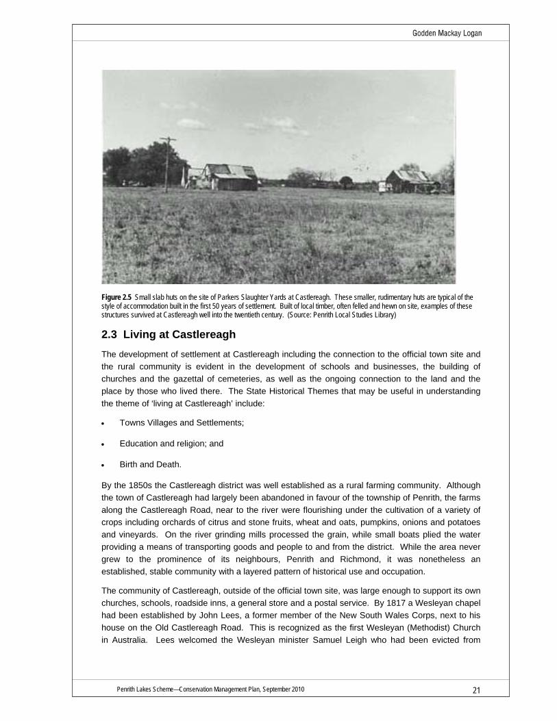
Figure 2.5 Small slab huts on the site of Parkers Slaughter Yards at Castlereagh. These smaller, rudimentary huts are typical of the style of accommodation built in the first 50 years of settlement. Built of local timber, often felled and hewn on site, examples of these structures survived at Castlereagh well into the twentieth century. (Source: Penrith Local Studies Library)
2.3 Living at Castlereagh The development of settlement at Castlereagh including the connection to the official town site and the rural community is evident in the development of schools and businesses, the building of churches and the gazettal of cemeteries, as well as the ongoing connection to the land and the place by those who lived there. The State Historical Themes that may be useful in understanding the theme of ‘living at Castlereagh’ include:
• Towns Villages and Settlements;
• Education and religion; and
• Birth and Death.
By the 1850s the Castlereagh district was well established as a rural farming community. Although the town of Castlereagh had largely been abandoned in favour of the township of Penrith, the farms along the Castlereagh Road, near to the river were flourishing under the cultivation of a variety of crops including orchards of citrus and stone fruits, wheat and oats, pumpkins, onions and potatoes and vineyards. On the river grinding mills processed the grain, while small boats plied the water providing a means of transporting goods and people to and from the district. While the area never grew to the prominence of its neighbours, Penrith and Richmond, it was nonetheless an established, stable community with a layered pattern of historical use and occupation.
The community of Castlereagh, outside of the official town site, was large enough to support its own churches, schools, roadside inns, a general store and a postal service. By 1817 a Wesleyan chapel had been established by John Lees, a former member of the New South Wales Corps, next to his house on the Old Castlereagh Road. This is recognized as the first Wesleyan (Methodist) Church in Australia. Lees welcomed the Wesleyan minister Samuel Leigh who had been evicted from

Penrith Lakes Scheme—Conservation Management Plan, September 2010 22
Sydney by Governor Macquarie who considered the Wesleyan faith to be a sect. Leigh presided over the opening of the Chapel in October 1817. By 1832 the chapel was reported to be in a dilapidated state and in 1840 it was reportedly gutted in a fire, although there is some dispute about the accuracy of this claim. The original chapel was replaced by a community funded church in 1847, which remains standing, including its accompanying cemetery both within the study site.
The cemetery site was laid out adjacent to the Church. Although it is reported as being opened in 1836, other reports suggest that the first burial was not until 1848, indicating a period of eight years in which the cemetery lay empty. This date (1848) also corresponds with the opening of the new church building and may represent a new dedication of the cemetery. The cemetery remains in place and in use at Castlereagh.
A Church of England chapel and parsonage were also in place by c1813-14. The Reverend Henry Fulton was appointed as Chaplain in 1814 and continued to serve in the role until he died in November 1840. Fulton had been transported for his role in the Irish rebellion on 1798. His parsonage, school house and chapel were located on a glebe of 400 acres attached to the Castlereagh town site, close to Cranebrook Road on the eastern edge of the study area. The old church was destroyed by fire in the 1870s and a new church was built on the ridge in Castlereagh town, overlooking but not within the study area. The church is still in use in Church Lane, Castlereagh with clear views back to the houses and farms that make up the study area. As with the Wesleyan congregation, the Church of England dedicated a cemetery within the boundary of the Castlereagh town site (located on Church Street) with burials occurring from 1814. A number of prominent Wesleyan families, including John Lees himself (although he was later exhumed and re-interned with his wife in the Methodist/Wesleyan cemetery in 1921), were interned within this cemetery, which could explain the lack of burials between 1836 and 1848 in their own cemetery.24
Catholic worship was also being conducted in the study area from as early as 1806, with a Father James Dixon (also transported for his role in the Irish rebellion) serving as an independent Catholic Priest in the district from this time. There was no Catholic Church built in the area (the nearest being at Penrith), but a Catholic cemetery was established on the property of James McCarthy who buried his young daughter, Elizabeth in 1806. Surviving headstones in the cemetery date from the 1830s onwards.25 Commonly known as McCarthy’s cemetery, this cemetery still remains in use.
Along with the churches, early schools were established for the district children, including the private school house of John Single at Nepean Park, Reverend Henry Fulton’s school at his parsonage and John Pringle’s Wesleyan school in Lees’s chapel. Although there is a period in the 1850s when no school appears to be in operation at Castlereagh, by the 1860s there is once again a Wesleyan school, a small Catholic school and a Government school all taking students.26 The Government school was built in 1879, as the upper Castlereagh Public School, on Old Castlereagh Road, opposite the Methodist (former Wesleyan) church and cemetery. The school was designed for 67 students with a teachers residence built alongside. The school and residence were completed towards the end of 1879 and opened in 1880, with the first teacher Samuel Roseby living in the house from late 1879. By October 1880 Roseby had left and was replaced by Charles Paul who remained at the school until his death in 1895. The school continued to serve the community until its closure in 1975.
The importance of the position of the school teacher in the community is illustrated by the fact that between 1857, when a postal service began to Castlereagh and at least 1904, the post master in the district was the local school teacher, with mail being delivered to the teacher’s residence. The

Penrith Lakes Scheme—Conservation Management Plan, September 2010 23
central location of the school on Old Castlereagh Road made it an ideal place for the mail delivery. In suggesting the school teacher as the first post master in 1857, the letter hinted at the practical reasons for such a choice, saying in part:
I now beg to point out, that the object of the application for this route of mail was to have a Post Office or receiving and delivery office at Castlereagh proper (not the town where there are only two houses)…….
There is a respectable person with a family, who keeps a School in or near the Presbyterian Church there who would be very eligible and fit person as Post Master and who from his occupation is always at home, his name is Webster. I do not know his Christian name, Mr Fingle who lives close to this spot could give every information.27
In 1904 when a local store keeper applied to the Post Master General to take over the service, a petition was put together by the Mayor, with twenty five signatories to keep the post service with the school teacher.28 The list of signatories gives an insight into the community as well, with nine farmers, six labourers, an orchardist, a domestic servant and a gentleman listed.
The churches, cemeteries and schools serviced a small but complex community at Castlereagh. Each of the three main religions were strongly represented in the community, with a number of prominent families, most of whom could be traced back to the first settlement period and who had remained in the district. Although each of the religious congregations were tight-knit communities, there is clear evidence that they also married, traded and dealt with each other.
The community of Castlereagh never reached a population much above 1200. It meant that families were close to each other and their neighbours, whatever their religious background, lending a helping hand when required. The exhumation of John Lees and his wife from the Anglican cemetery in 1921 for reburial in the Methodist cemetery may suggest a certain level of sectarianism in the community.29 Church outings and social events, were however, attended by members of the different churches, were a regular feature of the community life at Castlereagh well into the twentieth century.30 Other social groups, such as the Country Women’s Association (CWA) established in Castlereagh in 1934, just twelve years after its creation, also provided regular gatherings such as dances and fundraisers for the community, as well as a social network for women of the district.31 Still, the distance between houses and the demands of life on a working rural property meant that most social activities were often the result of other activity, for example visiting a neighbour was usually associated with work or business, with socializing coming next, or dances and gatherings were for fundraising rather than specifically for the gathering.32
During the nineteenth century and much of the twentieth century, employment for the population of Castlereagh was found locally. A large number of workers were employed in rural industries through the nineteenth century in agriculture or as labourers, with domestic servants also employed in some of the larger houses or in neighbouring Penrith. As well as working directly on the land there were a number of related businesses, such as blacksmithing, butchering and carting, all of which were represented at Castlereagh.33 A general store was also operating in Castlereagh from the turn of the twentieth century, with an agent for the Nepean Times, a shoemaker in the old Castlereagh town and a meat delivery by the butcher Henry Parker from the 1870s.34
The industrial advances of the later twentieth century weakened the traditional bonds between the families and also to the land itself for many. The modernisation of work practices, such as the introduction of milking machines meant less workers were needed on properties, but larger herds could be run. Following World War II, the sale of more farms to gravel companies, an aging local population and opportunities for work outside the district further weakened the family links and the social network of the community.35

Penrith Lakes Scheme—Conservation Management Plan, September 2010 24
Despite the apparent weakening of the bonds of community and family, many of the residents who remain at Castlereagh retain a strong connection to the place, forged through two hundred years of settlement in the area. The long term families were saddened at the changing nature of the place, especially physically, as the gravel mines further encroached into the old farming landscape. Not only were their familiar surroundings rapidly being consumed by the excavations, but the work was being undertaken by large extraction companies, not locals. While the first gravel and sand mining had been undertaken in the 1880s by Castlereagh locals, by the 1940s and 1950s the larger companies such as Boral had entered the lucrative sand industry, although they still managed to employ a number of local workers. As the quarry operations expanded, tensions grew between some families who had members working in the quarries and those still on the land. As the river was altered through the extraction of material, the water supply to some farms began to be affected. At least one incident is recorded of a quarry worker who left his job after his father’s farm lost access to the water it had relied upon and the tension and discontentment of the impact of extraction on the local farmers grew.36 This suggests an awareness amongst some workers of the irreversible nature of their work and to an emotional connection to the place that they were helping to re-develop. There was the reality, however, that the lure of a large payment for farm land by the gravel companies encouraged some to sell their family farms, (in some cases leasing them back) which in turn led to the eventual destruction of the farming use through the mining activities.
From the 1950s a growing prosperity was evident amongst those workers in the area who were employed by the quarries. Payments for farms that had outlived their productive life, especially the smaller allotments, helped these families financially. Evidence also remains in the landscape of the local use of the very products of the mining. A number of houses at Castlereagh were constructed using locally mined gravel and sand. During construction, small and large river pebbles were mixed with the concrete as an aggregate. A number of these mass concrete houses both intact and ruined remain at Castlereagh, built using concrete formed in a similar manner to pise construction, having packed down layers of concrete forming the walls.
The connection to ‘place’ for the residents of Castlereagh had grown over generations and through a process of working the land and families working with each other on the land. Throughout this period local Aboriginal people maintained their cultural connections to country. This was despite experiencing serious dislocation and being subjected to successive changes in government policy during the nineteenth century and twentieth centuries. The establishment of the Aborigines Protection Board in 1883 ushered in a period of authoritarianism and increasing government intervention into the lives of Aboriginal people. In the 1940s the Aborigines Welfare Board was established and Aboriginal people were expected to ‘assimilate’ into the ways of the white community. The Board provided basic support including blankets, clothing and welfare to Aboriginal people, they also assumed responsibility for the custody of Aboriginal children, they managed and regulated Aboriginal reserves and conducted regular inspections. Throughout the period of the Welfare Board’s operation Aboriginal people were resilient and adapted to the vastly different and challenging circumstances of their lives.
Today the Aboriginal community in the Penrith area is represented by a number of groups including the Deerubbin Local Aboriginal Land Council, the Darug Tribal Aboriginal Corporation and the Darug Custodian Aboriginal Organisation. The Aboriginal community are actively engaged in promoting and building a growing awareness and understanding of Aboriginal cultural heritage in western Sydney. The establishment of Muru Mittigar in 1998 in conjuction with the Penrith Lakes Development Corporation was an Aboriginal led initiative. Muru Mittigar is an Aboriginal Cultural Heritage Centre at Castlereagh, an initiative of the Aboriginal community of Western Sydney which

Penrith Lakes Scheme—Conservation Management Plan, September 2010 25
seeks to acknowledge the Darug people and their traditional custodianship of the Sydney and Castlereagh district, and recognises their ongoing connection to the land and their continuous cultural association with the area.37
2.4 Shaping the Land The changing land uses in the area, from the natural environment, Aboriginal land use to settlement and farming including responses to flood as well as historic and current mining and planning developments. The State Historical Themes that may be useful in understanding the shaping of the land include:
• Environment-naturally evolved;
• Aboriginal cultures and interactions with others;
• Agriculture and pastoralism;
• Environment-Cultural Landscape;
• Land Tenure; and
• Mining and Industry.
The land and landscape around Castlereagh are dominated by the flow and position of the Nepean River. The river marks the western boundary of the study area, where its otherwise meandering course straightens flowing a relatively straight south to north path. To the east the ground rises up to the position of the Castlereagh town site, while across the river the area is overlooked by Emu Plains and the foothills of the Blue Mountains. The Blue Mountains act as a visual barrier, giving the area a clear edge and an apparently impenetrable backdrop. The rising foothills reinforce the river as the edge of the Cumberland Plain and the settled districts which contributed to the first European settlers feeling of being on the frontier. The foothills of the Blue Mountains were also deeply coursed by a number of streams and small creeks that had carved through the sandstone escarpment, creating a series of valleys that funneled their waters into the Nepean. In times of heavy rain these streams and creeks swelled with water with the Nepean River oft times being in flood. The flooding was part of the natural cycle of the river, replenishing the surrounding countryside as well as building up deposits of soil and gravel along its banks.
The land around the river was covered with large forest trees such as red gum, broad leafed apple and iron barks which grew from the alluvial soils on the flood plain. In the undergrowth and along the river bank grew edible yams, berries and fruit. Freshwater lagoons and wetlands were home to an abundance of animals and birds. Small sand bars and river beaches slowed the rivers flow, allowing for deep pools to form. The river had also laid down deep reserves of sand and gravel, much of it hidden away under the topsoil that supported the forest.
Aboriginal people are thought to have begun living in the district around the Nepean River upwards of at least 14,000 years before the arrival of non-Aboriginal people.38 Their patterns of landuse changed the landscape of the study site. Aboriginal use of fire altered the flora and fauna of the area. It is likely that prior to their arrival, the area was more densely wooded, with rainforest and Casuarinas. However, the increased frequency of fires led to a rise in dominance of more fire resistant eucalypts and the creation of more open grassland areas. The practice of lighting fires at the base of trees to smoke out possums and other animals likely contributed to the forest fires.39
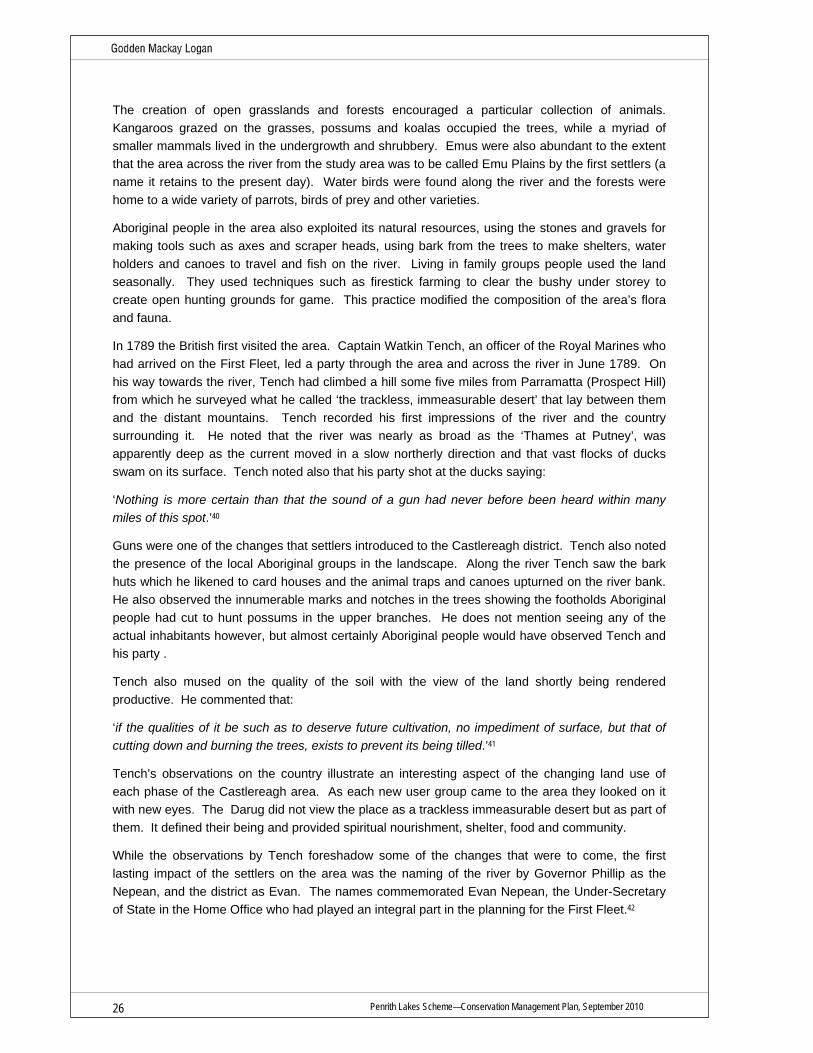
Penrith Lakes Scheme—Conservation Management Plan, September 2010 26
The creation of open grasslands and forests encouraged a particular collection of animals. Kangaroos grazed on the grasses, possums and koalas occupied the trees, while a myriad of smaller mammals lived in the undergrowth and shrubbery. Emus were also abundant to the extent that the area across the river from the study area was to be called Emu Plains by the first settlers (a name it retains to the present day). Water birds were found along the river and the forests were home to a wide variety of parrots, birds of prey and other varieties.
Aboriginal people in the area also exploited its natural resources, using the stones and gravels for making tools such as axes and scraper heads, using bark from the trees to make shelters, water holders and canoes to travel and fish on the river. Living in family groups people used the land seasonally. They used techniques such as firestick farming to clear the bushy under storey to create open hunting grounds for game. This practice modified the composition of the area’s flora and fauna.
In 1789 the British first visited the area. Captain Watkin Tench, an officer of the Royal Marines who had arrived on the First Fleet, led a party through the area and across the river in June 1789. On his way towards the river, Tench had climbed a hill some five miles from Parramatta (Prospect Hill) from which he surveyed what he called ‘the trackless, immeasurable desert’ that lay between them and the distant mountains. Tench recorded his first impressions of the river and the country surrounding it. He noted that the river was nearly as broad as the ‘Thames at Putney’, was apparently deep as the current moved in a slow northerly direction and that vast flocks of ducks swam on its surface. Tench noted also that his party shot at the ducks saying:
‘Nothing is more certain than that the sound of a gun had never before been heard within many miles of this spot.’40
Guns were one of the changes that settlers introduced to the Castlereagh district. Tench also noted the presence of the local Aboriginal groups in the landscape. Along the river Tench saw the bark huts which he likened to card houses and the animal traps and canoes upturned on the river bank. He also observed the innumerable marks and notches in the trees showing the footholds Aboriginal people had cut to hunt possums in the upper branches. He does not mention seeing any of the actual inhabitants however, but almost certainly Aboriginal people would have observed Tench and his party .
Tench also mused on the quality of the soil with the view of the land shortly being rendered productive. He commented that:
‘if the qualities of it be such as to deserve future cultivation, no impediment of surface, but that of cutting down and burning the trees, exists to prevent its being tilled.’41
Tench’s observations on the country illustrate an interesting aspect of the changing land use of each phase of the Castlereagh area. As each new user group came to the area they looked on it with new eyes. The Darug did not view the place as a trackless immeasurable desert but as part of them. It defined their being and provided spiritual nourishment, shelter, food and community.
While the observations by Tench foreshadow some of the changes that were to come, the first lasting impact of the settlers on the area was the naming of the river by Governor Phillip as the Nepean, and the district as Evan. The names commemorated Evan Nepean, the Under-Secretary of State in the Home Office who had played an integral part in the planning for the First Fleet.42

Penrith Lakes Scheme—Conservation Management Plan, September 2010 27
Despite the area’s apparent potential for cultivation it was to be another fifteen years before settlers began to make any permanent settlement in the area. Prior to 1804, the rural settlements away from Sydney and Parramatta had been located further north on the Hawkesbury River around present day Windsor and Richmond. Here the river was easier to navigate and produce could be shipped, and supplies, returned by boat from Sydney town. The Castlereagh area by contrast was isolated, the river shallower and less navigatable. In 1804, when the first grants were laid out, a single road was the only reliable access to the area, coming from the north out of the settlements at Richmond and Windsor. The settlement’s isolation during its formative years was illustrated in March 1806 following a flood on the Nepean and Hawkesbury. The Sydney Gazette wrote that:
Much apprehension was entertained for the fate of the settlers on the Nepean; from whence some satisfactory intelligence has been received, but no certain accounts of the losses at that place or the Hawkesbury can yet be depended on. Yet it is sufficiently obvious, that but little short of the present destruction of private property in that Settlement is the consequence of this uncommon deluge’.43
Floods were a common feature of life on the banks of the Nepean. Tench commented on evidence of a flood of over forty feet above the river level on his journey to the Nepean in 1789. The 1806 flood as reported in the Sydney Gazette swept away 200 wheat stacks and 4,000 head of stock from the Nepean and Hawkesbury farms. Another flood in 1811 gave a brief boost to the newly surveyed town of Castlereagh, immediately to the east of the study area on a small ridge overlooking the flood plain.44 Indeed the site for the town had been partially chosen by Governor Macquarie as a response to the floods in the district (see Figure 2.6). Ironically the site was also removed from any easily obtained fresh water, which in turn led to its eventual failure as a viable town settlement.
The enduring settlement in the region then was on the floodplain between the town and the river. It was here that the first grants had been made in 1804 to emancipists, free settlers and soldiers, fronting the road to Richmond and the banks of the river. The grants were laid out along the road or between the road and the river, the maps of the parish showing the parallel lines of the grant boundaries that stamped the arrival of a new bureaucracy on the landscape. The shape of the land is not considered in the initial land parcels, only the position of the town of Castlereagh indicates the topography of the area, it being set on a diagonal to the majority of the parcels and so displaying the position of the ridge line above flood reach.
Almost all of the grant allotments were between 80 and 200 acres, not the large sprawling estates of the inner Cumberland Plain area, the exception being 1300 acres granted to William Chapman in the south of the study area near Birds Eye Corner. Chapman was Governor King’s secretary and he named his grant Lambridge Farm.45 The size of the farms give a clue to the status of the grantees, important enough to the fledgling colony to deserve the land but not influential enough to gain large portions of it. The different farm sizes were also unusual in that they were a response to the needs and capabilities of the individual. The size also dictated what land use was possible on the site. The farms were best suited to hand sown crops, small herds of cattle or livestock, pigs and market gardening or orchards and by the 1820s these are the activities that are recorded as occurring in the area.46 Similarly, the small scale of the allotments and lack of any other larger grants in the area (Chapman’s farm was subdivided for tenant farmers as early as 1806) meant that many of the original land allotments survived through the nineteenth and twentieth century into the present, leaving a clear pattern of the first grants on the remaining sections of the current landscape.

Penrith Lakes Scheme—Conservation Management Plan, September 2010 28
The first land holders were required to clear a certain portion of their lands as a condition of the grant. The land was quickly cleared, with timber used for building and fencing and the excess burnt or left to rot, just as Tench had prescribed fifteen years earlier. The land was tilled and crops sown. Vineyards, wheat, maize, orchards of citrus and other fruits were soon a feature of the district. While some crops were more successful than others—for example maize survived while wheat was abandoned after rust entered the areas from the 1860s—the farms along the river front displayed a working link to the colonial settlement with the area being one of the oldest continually farmed portions in Australia.
The creation of the rural landscape by the settlers had inevitable consequences on the land itself and the flora and fauna that had inhabited it. As discussed, the trees and undergrowth were quickly cleared for the majority of the area, to the extent that Governor King had to intervene to slow the process. With the removal of the bushland, the native animals also begin to disappear. Mrs Charles Meredith, traveling through the area in the early 1840s, commented on this loss, already apparent after less than forty years of settlement. In crossing the Nepean at Emu Plains she observed:
‘Ourselves, carriages, and horses were safely ferried over the Nepean in a large punt….when we drove merrily along the Emu Plains, so named no doubt from the flocks of emu formerly found there; but as civilized (sic), and therefore doubly destructive, man advances in a new country, he invariably exterminates or scares away the timid creatures that have for ages dwelt there undisturbed…47‘
The change and decline in native animals is still occurring with native fish stocks recorded as declining through the twentieth century and introduced species such as European carp becoming more prevalent.
The clearing carried out by the farmers also illustrates the different understandings of land use by the different users. The settlers did not see or have use for the natural bushland that covered the land on their arrival, it was an unproductive space that needed civilizing. Crops and grazing animals could not thrive in the Australian natural landscape. It was a decision based on the lack of understanding of the ecosystems as much as the economic return of the land. Initially paramount was the need for food for the fledgling colony to survive. From the 1850s and 1860s as disease began to inhibit the production of some crops, especially the impact of rust on wheat and other grains, new crops were tried. Orchards became common on a larger scale from the later nineteenth century. Properties such as Minnaville, located on 90 acres granted to John Harris on the Castlereagh Road next door to Nepean House had orchards of stone fruits early in its history, with claims that it was the first stone fruit orchard in Australia.48 Later, oranges were also planted at Minnaville and elsewhere across the study area, particularly around Birds Eye Corner (see Figures 2.7, 2.8).
Alongside the orchards, from the late 1890s dairy farms also began to appear. By 1900 there were more than fifteen dairy farms at Castlereagh after which they grew to prominence as one of the major land uses of the area, alongside mixed farming and orchards.49 Dairying remained a major rural industry in the Castlereagh area throughout the twentieth century. In the 1920s the Nepean Dairy Company was established and a milk factory was built close to the railway line in Penrith. At its peak the district (north of the railway including the study area) had 230 suppliers to the factory, with herd sizes being around 35-40 cattle each.50
Other important land uses in the study area were Chinese market gardeners had been present in the study area in the 1880s and 1890s, while in 1923, underwear manufacturers GA Bond & Co,

Penrith Lakes Scheme—Conservation Management Plan, September 2010 29
grew Australia’s first cotton crop on 70 acres on the corner of Old Castlereagh Road and Church Lane.51
The farms were a mix of tenant farmers and owners. The prevalence of tenant farmers has been argued as a reason for the relatively scarcity of substantial buildings in the Castlereagh.52 But of course there were buildings in the landscape. The large two storey houses at Nepean Park and Hadley Park overlooked the more common single storey houses that most of the community lived in. Weatherboard cottages were the norm, with the house called Puddledock, which remains in the study area, being a typical (although now rare) example. A timber slab cottage in the grounds of Hadley Park has been tentatively identified as possibly the oldest timber slab building in Australia dating from c1806.
In recent years, many of the farm sites have been excavated in the search for and extraction of gravel and sand. Sand and gravel mining along the Nepean River dates from the later nineteenth century in response to the increasing use of reinforced concrete in building construction, the cessation of the use of sandstone and improving road building techniques. The Nepean River at Castlereagh is the only source of river gravel within the Cumberland Plain, formed from deposits of Palaeozonic rocks, such as porphyry, granite, quartzite and slate found in the upper Warragamba catchments. These rocks have broken down over time and been washed downstream to the floodplain around Castlereagh. Further downstream gravel deposits are found at too great a depth to be economically extracted.
The first mining company of any size in the Castlereagh area was the Emu Gravel and Road Metal Company located in Emu Plains opposite Birds Eye Corner. The Emu Gravel and Road Metal Company operated from the 1880s well into the second half of the twentieth century. Gravel and metal were vital raw materials used in housing construction, public and commercial buildings, roads, railways, airports and water and sewage systems. Finely crushed stone is also used in medicines and other products such as paint and cosmetics.
As well as supplying sand and gravel for the booming Sydney suburbs in the later nineteenth and early twentieth century, the Emu Gravel and Road Metal Company also supplied the bulk of raw material (in the form of sand and gravel) for the construction of the Warragamba Dam in the 1950s. In a curious twist, the construction of the Warragamba Dam also meant that the natural flow of gravel from the catchment area to the Castlereagh was blocked, meaning there could be no renewal of the resource (although the extraction level was always higher than the renewal anyway).53
By the 1920s there were a number of quarries operating along the Nepean and a number of local families were part of the labour force for the industry. Oral history recordings undertaken by OHM Consultants in 1998 for PLDC provide an insight in the day to day working life of men who were employed in the industry in the district. Bill Pearson, remembered his father and grandfather working for the Emu Sand and Gravel. Bill’s grandfather told him that in the early 1900s that gravel was manually extracted from the river bed and loaded onto a horse and cart. Bill’s father, worked for the same Company and remained there for nearly thirty years. His job involved washing and grading sand and running the rail steam engines that transported it.54 During the 1940s there were a number of smaller quarrying companies working at Castlereagh and there was plenty of work for local men shoveling rocks. The work was physically demanding and not without health risks, but the wages were ‘good’. 55

Penrith Lakes Scheme—Conservation Management Plan, September 2010 30
Initially the sand and gravel was extracted directly from the river, using steam shovels and later (from the 1940s and 1950s) larger diesel powered draglines that could extend over the river and scoop higher quantities of material in each pass. The material was generally at a shallow level, having been deposited on top of a under layer of Wiannmatta Shale. Once the raw material was extracted it was sifted to separate the sand from the gravel. Sand was then transferred to stockpiles, gravel was separated from stone and sized and the remaining stone was crushed and graded. The material was then distributed direct to site via road transport or taken to the railheads at Penrith or Richmond for transport to city markets.56
As demand for the resource grew, so to did the number of quarry operators in the district. By the early twentieth century quarries were extracting gravel along the river from Penrith to Richmond. The Blue Metal Industries (BMI) Power Gravel Plant which was constructed around 1946, was located on the southern side of Jackson’s Lane in the Penrith Lakes area. The plant was a reminder of the smaller scale quarries that provided gravel and other material prior to the arrival of larger scale operators such as CSR, Yarramundi Properties (a subsidiary of Melocco Bros) and Boral.
The quarry companies realizing the potential of the resource at Castlereagh and also the limited time frame on direct extraction from the river itself, undertook to purchase much of the land fronting the river from the 1950s onwards.57 Farms were gradually purchased for future mining options. Many of these farms were the remaining original grant areas from 1804, and the former owners were allowed to continue using the land (or new leaseholders were sought) until the gravel was needed. The 1950s and 1960s brought with it considerable changes to the mining industry. The introduction of new technologies triggered higher productivity and profitability. Operating hours were extended and the labour force expanded working in shifts around the clock. The river gravel and sand resources were exhausted by the 1970s and many of the smaller companies closed down. The larger ones turned their attention to the farming land they had acquired and amalgamated their holdings, in some cases leasing the land back to the occupants for agisting stock, dairying or turf growing. The quarry companies paid handsomely for the land, in the words of one former owner ‘it was a fortune’.58
The nature of sand and gravel extraction meant that productive farmland would inevitably be lost in the process. The land use decision was not without issue. To many that had farmed the land over generations removing the highly fertile alluvial to extract gravel and sand was very difficult to accept. Yet the value of the raw materials to the Postwar construction industry that was building Sydney’s booming suburbs and new high rises in the city over the value of the food production which was also needed to feed Sydney’s growing suburbs, was not lost on the minerals industry either. A 1962 report into the extractive industry in the County of Cumberland noted:
A major source of sand and river gravel is the Nepean River downstream from Penrith, where large scale dredging and screening are carried out…..In parts of the Penrith district near the river, sand and gravel underlie good agricultural alluvial soil. There has been some conflict of opinion as to whether extension of sand and gravel extraction on this land is in the public interest. 59
Still the expansion of the open cut quarries further into the former farm land was almost inevitable as Sydney’s suburbs began to expand through the 1960s and 1970s (see Figure 2.9). Comparisons of aerial photographs from 1947, 1961, 1971, 1978 and 1986 show the expansion of the quarries from Birds Eye Corner, along the river bank and then from 1971 further inland away from the river. The extraction of the gravel has resulted in the most dramatic reshaping of the land form and has radically altered the traditional rural landscape that had previously characterized the

Penrith Lakes Scheme—Conservation Management Plan, September 2010 31
Castlereagh area. The river geomorphology had also been altered significantly through the removal of gravel and sand from the river channel. During the 1960s a growing disquiet and concern was developing regarding the environmental degradation and loss of a visually appealing rural agricultural landscape at Castlereagh. Planning approvals for quarrying at Castlereagh had been piecemeal and there was the grim realization that there was real risk of the government being left with a tract of wasteland when there was considerable pressure on the local government area to provide land for a growing urban population.
In the mid 1960s Penrith City Council resolved that they would issue no further development consents for quarrying at Castlereagh until the resultant environmental impacts were addressed. A planned and coordinated response was required if mining was to continue and the land was to be remediated. The concept of creating a series of recreational lakes with residential development in a parkland setting first emerged as the vision for the site at this time.60 For the quarry companies it created an operational environment where they would no longer have to work inefficiently on a small scale but rather increase quarrying operations over the 2000 hectare site designated as Penrith Lakes and create an open cut mine.
By 1979 the larger quarrying companies that were operating at Castlereagh had combined their interests and commenced operating as part of the Penrith Lakes Development Corporation (PLDC). PLDC was a joint venture between Boral, CSR and Pioneer. At that time there was an estimated ten years of supply remaining at the Penrith quarries. The site provided about 75% of Sydney’s sand and crushed aggregate requirements, including about 85% of the materials for ready mixed concrete.61 The consortium continued to buy up farming land in the area during the period. Many owners sold their land but others refused. In 1977 a feasibility study was undertaken to determine whether the proposed redevelopment and remediation of the land was viable. The study expressed the far sighted vision and optimism of the period and even the National Trust thought the scheme had merit.62
By the 1980s sentiments had started to change. The local community galvanised and formed action groups such as The Friends of the Nepean led by Marilyn Jones. The local paper regularly featured articles about the neglect of history and heritage at Castlereagh with attention grabbing headlines. ‘Save our History Houses will be lost in the lake’.63 In 1982, historical archaeologists, Fran Bentley and Dr Judy Birmingham prepared a History of European Settlement for PLDC. The report noted that the environmental heritage of European settlement at Castlereagh was some of the earliest in Australia and included an inventory of over fifty eight items of environmental heritage.64
The passage of the Environmental Planning and Assessment Act in 1979 created a new statutory context for the assessment of environmental impacts. In 1981 a Regional Environmental Plan (REP) was prepared to provide an overarching framework for implementation of the Penrith Lakes Scheme. Three years later, in 1984 a Regional Environmental Study (RES) was as undertaken. The study, one of the first of its kind under the new legislation, was underpinned by a range of consultant reports including for Aboriginal and European Heritage.65 The RES served as a model for subsequent approvals for development at Penrith Lakes including Development Application 2, DA3 and DA4. The Regional Environmental Plan No. 11—Penrith Lakes Scheme (SREP 11) was made by the Minster for Planning and Environment in 1986. Since 1986 the SREP has been amended on a number of occasions to reflect changes in the development of the Scheme. 66

Penrith Lakes Scheme—Conservation Management Plan, September 2010 32
In 1987 PLDC and the State Government of NSW signed a Deed of Agreement which covered the quarry operations and the completion of the scheme including the development of parklands and urban land and provisions for the creation of the Sydney International Regatta Centre. More heritage reports were commissioned by PLDC including a history of European settlement by Carol Liston and a cultural landscape assessment study by Geoffrey Britton and Colleen Morris in 1999. In 1998 OHM Consultants were commissioned to undertake an oral history project which involved several descendants from families that had lived in the Castlereagh area from the early 1800’s. Throughout this period the community continued their vocal protests against the scheme. Marilyn Jones at Penrith City Council meeting in May 1998 referred to a petition that was to be presented to the Minister which included over 2,500 signatures.67
Through PLDC, the quarries have been and are continuing to be redeveloped into a lakes scheme and urban land development. The company’s role is to facilitate a coordinated and systematic approach to the extraction of sand and gravel deposits within the Scheme area. As extraction ceases, Penrith Lakes is rehabilitating the former mined areas and re-creating a parkland setting for residential development and water-based recreation. As the quarry sites have been exhausted, the remaining excavations are proposed to be filled with water, creating large artificial lakes.
While quarrying continues in the area, some lake sites have been completed, most notably the Sydney International Regatta Centre that was finished for the 2000 Sydney Olympics. The Sydney International Regatta Centre was developed into a recreational public open space that was handed over to the State Government upon completion. The regatta centre includes a two-kilometre course for rowing and was one of the sites of the 2000 Olympics. It hosted rowing and the whitewater rafting events. Today the Centre is used for a range of different purposes including picnicking, dragon boat festivals and wake boarding. There is a cycleway around the lakes that is used for walking and rollerblading.
The future development of Penrith Lakes will not be possible without an impact on the past. The enduring rural colonial landscape of parcelled land was evident well into the 20th century and the local community cherished its beguiling simplicity and long familiarity. Realising the vision for urban development at Penrith Lakes has not been without debate and protest. The scheme has sharply etched the differences between the politics of power and the politics of place. Even today, local people, politicians and developers eye each other with an uneasy suspicion and restless alliance at the best of times. In a paper reflecting on the interaction between people, place and government, historian Grace Karskens notes;
Cities are critically vulnerable when their people lose faith or interest in them and in their own ability to shape and improve them; when they feel their own stake in urban palces are ignored or bulldozed; when they feel policies and laws are imposed upon them without consultation or consideration. These are conditions which foster withdrawal into private havens, little worlds.68
In February 2007 the Minister for Planning Frank Sartor, announced that the Penrith Lakes Scheme would be considered a State Significant site under Part 3A of the Environment Planning and Assessment Act. The scheme included residential development with water views and access in a parkland setting that would augment the recreational opportunities in the area already offered by the International Regatta Centre. The Government urged the community to get involved in the consultation process and to influence the ‘detailed planning for this once-in-a-lifetime opportunity to leave a beautiful legacy for ourselves and future generations’. There is little argument that the Penrith Lakes Scheme is a major landscape intervention. It combines dramatic aspirations for the future and impacts in concert.

Penrith Lakes Scheme—Conservation Management Plan, September 2010 33
Figure 2.6 Flood at Castlereagh. Floods were a common feature of the settlement at Castlereagh, with the first being recorded in the Sydney Gazette in 1806. Houses, livestock and people were all too often lost in the wild torrents. (Source: Penrith Local Studies Library)

Penrith Lakes Scheme—Conservation Management Plan, September 2010 34
Figure 2.7 A view to the foothills of the mountains across the orchards at Minnaville, c1950. Orchards were one of the variety of agricultural uses to which the land around the study site was put, with references to stone fruit orchards as early as the 1830s. (Source: Gray, JA 1988, Magnificent Minnaville, Nepean Historical Society)
Figure 2.8 A view across the horse paddocks at Minnaville, c1950. (Source: Gray, JA, 1988, Magnificent Minnaville, Nepean Historical Society)

Penrith Lakes Scheme—Conservation Management Plan, September 2010 35
Figure 2.9 A dragline extracting river sand and gravel from the river at Castlereagh. The Nepean was the only source in Sydney of river sand and gravel usable in the construction industry. As Sydney began to expand and the use of concrete increased, the demand for the sand and gravel increased as well. From the 1890s, ever-larger extraction and quarrying operations were opened at Castlereagh to exploit the resource. (Source: Blue Metal Industries Activities Review 1963)
2.5 Seeing and Representing the Land The response of artists and writers to the landscape of the Nepean River and the Castlereagh area from the colonial experience to the emerging Australian landscape scene of the late nineteenth and early twentieth century. The State Historical Themes that may be useful in understanding how the landscape was represented include:
• Creative Endeavour;
• Exploration; and
• Environment-Cultural landscape

Penrith Lakes Scheme—Conservation Management Plan, September 2010 36
Depictions of the Castlereagh, in the form of painting, verse and photography have been a feature of the interaction with the area over two centuries of white settlement and reflect the changing nature of not only the physical nature of the landscape but also of the artistic response to the landscape.
For those who had settled at Castlereagh from 1804 onwards, the early years were defined more by a daily combat with the land, the treachery of the flooding river and the isolation of the place from the main settlements rather then any thing other then a casual eye towards the artistic beauty inherent in the place. The first artists to approach the area were most often attached to the exploration parties, searching for routes over the seemingly impenetrable mountain barrier. The focus of these parties was not on the scenic nature of the region, but rather the viable expansion of the settlement and the search for a passage to the west. During Governor Macquarie’s tour of the settled districts in 1815, John William Lewin (1770-1819) travelled as the artist for the party, painting scenes that depicted the Australian landscape and its flora and fauna with a shrewd clarity. Lewin was the first major artist through the Castlereagh area, although most of his views depict sites further into the mountain crossing than at Castlereagh.69 The scarcity of surviving imagery from the earliest settlement period can also be, in part, ascribed to the early artist’s general distaste for the Australian landscape. The jarring difference of the Australian scene to their familiar European landscapes appears to have confounded many, who took the Australian bush to be uninspiring, unattractive or merely a melancholy scene.
The first images of the Nepean around the study area (c1820s) depict exploring parties camping on the banks or attempting to cross the river. The paintings depict the area in a romantic or picturesque manner, familiar to artists and audiences of the period. The trees and vegetation are most often stylized to resemble familiar European varieties, with large rock overhangs or distant mountains taking the place of the castles or ruins of European picturesque paintings (see Figure 2.10). These views were still largely depicting the exploring parties in the wilderness, with boats heading up river or of Aboriginal groups placed in a romantic landscape rather then any depiction of the struggling farmers on the river flats or the developing townships. Other settlements such as Parramatta, Newcastle or Sydney itself provided more interesting urban subjects than Castlereagh could at this time.
Other than the farms along the river front, there was not much development at Castlereagh throughout the nineteenth century. In turn, there was little to attract the colonial artists who were predominately interested in either the wild exotic country or the growing progressive settlements, neither of which existed in any great form at Castlereagh. By the mid nineteenth century the bushland had been largely cleared except for areas in the rugged foothills of the mountains or further upstream from Castlereagh. An exception to this is a number of depictions of the river crossing to Emu Plains. Conrad Martens sketched a number of scenes on the Nepean River around the Castlereagh area.70 One shows the primitive hand drawn cable ferry crossing the river with a number of passengers standing on its platform while others wait on the far western bank. This sketch also shows a small house and its fenced yards on the far bank. Martens visited the area in May 1835 at a time when he was making a living painting Australian scenes for local sale or through the patronage of the social elite. Although his views are still romantic in nature, they do depict a more realistic scene than some of the earlier works, maybe reflecting the emerging desire of locals to have a closer representation of their place than previously realised. Another of Martens’ Nepean scenes looks across the river and depicts a windmill on the far bank as well as homestead on the small ridge above the river, scenes typical of the study area in the 1840s. (see Figure 2.11)

Penrith Lakes Scheme—Conservation Management Plan, September 2010 37
Approximately ten years prior to Martens’ visit, a local resident Charles Tompson had published a series of poems which in part reflected on his life at Castlereagh. Tompson had been born in Sydney in 1807 and had moved to Castlereagh with his family as a child in c1814 where he attended the parsonage school of Reverend Henry Fulton. In 1826 he published a book of poetry, Wild Notes, from the Lyre of a Native Minstrel, amongst which was the poem Retrospect or A Review of my Scholastic Days which covered his time with Reverend Fulton and his life at Castlereagh. The poems were the first published by an Australian born European poet and the first known to consider the Castlereagh area. The poem deals with Castlereagh in a lyrical manner but hints also at the nature of cultivation and farming that are being carried out on the banks of the Nepean. For while Tompson reflects on ‘Fair Castlereagh’ the ‘Majestic daughter of th’ expansive plain, Where rural stillness holds her placid reign’ he also asks
‘What luxuries within Nepean’s bankments dwell! Refresh’d thro’ Zean fields we heedless rove, To where Pomona revels in the grove; We feel the goddess’s ambrosial breath, Luxurious curling in the shade beneath; Her luscious peach diffuses fragrance around, From cluster’d branches bending to the ground;71
In his notes to the text Tompson explains that Zea mays is the botanical name for Indian corn which was abundantly cultivated along the banks of the Nepean, while peaches of excellent quality also grew in the area. His reference to Pomona, the Roman goddess of the harvest adds to his allusions to the abundant fertility of the Castlereagh farms.
Despite these early artistic and poetic flourishes, the Castlereagh area begins to fade from the mind of the artist community through the middle and second half of the nineteenth century. The area was seemingly re-discovered by artists during the closing years of the nineteenth century, with Julian Ashton, Charles Condor, Henry Fullwood and Arthur Streeton all visiting the area between the 1880s and 1900. Ashton, Condor and Fullwood were working on the production of their Picturesque Atlas of Australia and together with Streeton’s later works on the Nepean, their works represented a grand period of Australian landscape painting. Streeton and Conder are considered as two of the founders of the Heidelberg school of painting in Australia. Each of the artists was drawn to the Nepean by their belief that the area conveyed something about the Australian landscape character, with its sun drenched fields, slow meandering river and the settled, rural nature of the scene. Streeton in particular produced a number of paintings of the area, with his work being identified as part of a growing sense of nationalism and national pride.72 His painting The Purple Noon’s Transparent Might, painted on a hill overlooking the river above Agnes Bank is immediately to the north of the study area. The painting looks south along the river and the farming land that makes up part of the study site. The painting captures the light, heat and languid nature of the river and surroundings, with the foothills of the mountains in the distant haze. Cows stand on the sand shore drinking from the river, a windmill sits close by and farm houses are visible dotted through the landscape. On the western bank, the bush still crowds the sloping river bank, suggesting at the untamed nature of the surrounds. Streeton’s Hawkesbury River series has been considered to be representative of an important turning point in Australian landscape painting, and in turn an important period in Australia art (see Figure 2.12).73
Into the early years of the twentieth century the artists continued to journey to the area, attracted by the light and rural scenery. Artists such as Elioth Gruner, would camp near Emu Plains and paint early in the morning to capture the atmospheric effects of the morning sun. His works such as Haystacks at Hawkesbury, Spring Frost, Emu Plains and Morning Light Emu Plains all painted between 1916 and 1927 encapsulate the plein air style of the day for which Gruner was well known. Gruner had in fact been a student of Ashton when he was younger, and his work, Morning Light,

Penrith Lakes Scheme—Conservation Management Plan, September 2010 38
won the Wynne Prize for landscape painting in 1916 (see Figure 2.13)74 Later, the abstract artist Frank Hinder also took inspiration from the area, painting his River Bank, Emu Plains in 1947.
As well as painters, writers were also still coming to the area looking for inspiration or solitude. Of these, the most distinguished and well known was Miles Franklin. Franklin was gaining some prominence with her first novel, My Brilliant Career and lived at Castlereagh between c1904-1906. During this time she wrote her manuscript for the novel Some Everyday Folk and Dawn which was published in 1909. The novel is set around the Castlereagh area and deals with a small country town and the first opportunities for women to vote, a topic that Franklin was passionate about, and one that had not been covered with any conviction in Australian literature to that time.75
The visual representation of the Castlereagh and the Nepean has in many ways reflected the changing attitudes held towards the place throughout settlement. The first views are of an untamed wilderness set upon by heroic adventurers striving to civilise it. Romantic impressions of the landscape were produced most often for English audiences and set to translate the unfamiliar bush according to recognisable European artistic styles and conventions. By the later nineteenth century, the growing awareness of the unique aspects in the Australian landscape, the quality of the light, colour and palette of the Australian landscape were combining with an increased nationalism. Painting in particular began to express this combination, especially through the Heidelberg school, which attempted to capture this style. Artists such as Streeton, Conder and Gruner were captivated by the area and through their work presented their ideal of the rural Australian scene, via Castlereagh, to a wider public.
Figure 2.10 Joseph Lycett’s View upon the Nepean River at the Cow Pastures NSW 1825. This painting of colonial artist Joseph Lycett captures the picturesque approach to landscape painting that was common amongst colonial artists. The unfamiliar bush setting is stylised to represent a more familiar European landscape. However, the bush is still shown as an unknown wilderness with Europeans on the fringes ready to discover it. (Source: National Library of Australia)

Penrith Lakes Scheme—Conservation Management Plan, September 2010 39
Figure 2.11 Conrad Martens, 1835, View on the Nepean River. Here Martens looks across the Nepean to show a faintly drawn house with yards and cultivation on the left, with a windmill situated on the banks to the right of the tree in the foreground. Martens was being commissioned by local people to do his work at this point, which could account for the more realistic portrayal of the scene than some earlier artists. (Source: State Library of NSW)
Figure 2.12 Arthur Streeton’s The Purple Noon’s Transparent Might, painted from the hills on the opposite bank to Agnes Bank in 1896. This painting captures the view back over the study area, with a glimpse of the river in the background and the mountains acting as a frame to the work. Streeton spent a number of years painting the Castlereagh area and his works are considered to be turning points in Australian landscape painting. (Source: National Gallery of Victoria)
Penrith Lakes Scheme—Conservation Management Plan, September 2010 40
Figure 2.13 Elioth Gruner’s Morning Light Emu Plans painted in 1916 shows the rural idyll as imagined by Gruner. The farmer watches over his cattle as they make their way to be milked, a modest cottage nestled amongst trees and gardens in the background. In the distance the foothills of the mountains and the glimpse of the river at their base; a scene typical of the study area around Castlereagh in 1916. Gruner, one of Australia’s premier plein air artists, won the Wynne Prize for Landscape painting with this work. (Source: Art Gallery of NSW)
2.6 New South Wales Historic Themes The thematic essays set out above have been written using the NSW Historic Themes as set out by the Heritage Council of NSW. These themes are intended to act as guidelines or indicators of why a place is significant. Some of these themes are relevant to more than one aspect of the study area, and so have been referred to twice, with different emphasis, such as Aboriginal cultures and the interaction with other cultures, land tenure, exploration and cultural landscape.
The state historical themes that were regarded as most useful for understanding the development of the Castlereagh and Penrith Lakes area, and the way they related to the study area, were:
• Aboriginal cultures and interactions with others–as illustrated in the Aboriginal occupation of the land prior to European settlement, their use of the resources of the land for food, shelter and manufacture, the first contact with the Europeans and reaction to it, and their continuing connection and custodianship of the area.

Penrith Lakes Scheme—Conservation Management Plan, September 2010 41
• Convicts–as illustrated by the settlement of ex-convicts at Castlereagh and the use of convict labour in the area to clear land and build some early dwellings, such as Nepean Park.
• Exploration–as illustrated in the colonial exploration of the area in the 1780s through to the early 1800s. The first Europeans reached the study area in 1789 and reported on the site to the Government. Other parties came through the area searching for a route over the Blue Mountains, while later travellers still explored the region on their way west.
• Land tenure–as illustrated in the early series of land grants in the study area, many of which were still clearly visible in the agricultural landscape until recent years. This theme also explores later land ownership, such as the consolidation of the smaller farms, long term ownerships and the more recent acquisitions by mining and quarrying companies.
• Agriculture and pastoralism–as illustrated by the rural use and setting of the study area, which was a feature, and remains a feature, of the landscape since the earliest days of European settlement. This also includes the process of creating this landscape, through felling and clearance of the bushland and the ongoing tilling and cultivation of the land.
• Environment-Cultural Landscape–as illustrated by the manmade landscape, including the effects of the Aboriginal landuse, the European clearances and farming, the construction of houses and buildings, the building of roads, the fencing and subdivision of land parcels and other human features, including the quarries and lakes that have contributed to the formation of the landscape.
• Towns Villages and Settlements–as illustrated by the growth of the settlement at Castlereagh, including the houses, inns, farm buildings, churches, schools and cemeteries.
• Mining and Industry–as illustrated by the gravel and river sand extraction industry, including the early sand removal from the river, the larger scale gravel quarries of more recent years and the remnant crushing plants and other infrastructure pieces that have contributed to the industry.
• Creative Endeavour–as illustrated by the artists and writers and their works inspired by and depicting the Castlereagh area.
These historic themes capture the stories of Castlereagh that are embodied in the heritage sites, historic photographs, archaeology, movable collections and in the memories and experiences of those families and individuals who have lived and worked at Castlereagh over generations.
Historic photographs, artefacts and objects prompt questions about what happened in the past and interpretation uses the narratives of the past and the evidence that remains such as historic images and other physical traces to develop initiatives which help communicate what happened at a particular place and what it was like to live through and experience different periods of the past.
As part of planning how to interpret and present the range of historic themes and stories at Castlereagh an understanding of the opportunities and constraints provided by the site and specific places needs to be documented. This enables future interpretive initiatives to be matched to specific locations and then integrated into broader interpretation planning for the site.
The history and heritage of Castlereagh presents a rich resource for telling stories about the ways Aboriginal and non-Aboriginal people have interacted with, responded to created and changed the landscape over thousands of years.

Penrith Lakes Scheme—Conservation Management Plan, September 2010 42
2.7 Chronological Timeline
1789 June Watkin Tench arrives at Nepean River with first European exploration party to area.
1799 A major flood of the Nepean River.
1803 1 July Mary Collett receives a land grant at 'Birds Eye Corner'.
1804 4 June John Lees receives land grant at Castlereagh. Later he gives part of this grant for a Methodist Church to be erected.
1804 11 August James McCarthy receives land grant which he later names Crane Brook Farm.
1806 A major flood of the Nepean River. First burial in McCarthy’s Catholic cemetery.
1809 A major flood of the Nepean River.
1810 6 December Governor Lachlan Macquarie names Castlereagh as one of his five towns.
1811 Surveyor James Meehan marks out the streets and square.
1811 A major flood of the Nepean River.
1811 Hadley Park built.
1814 28 April A glebe house and school completed for Rev Henry Fulton in Church Street.
1814 11 July Rev Henry Fulton's school opened. Called the Classical Academy for Young Gentlemen, this school was the first secondary school in Australia.
1814 First burial in Castlereagh Anglican cemetery.
1817 7 October The first Methodist chapel in the southern hemisphere opened, erected by John Lees.
1822 John Single builds Nepean Park.
1825 Rev Henry Fulton's school closed.
1835 Conrad Martens visits and paints Castlereagh area.
1836 4 August Ann Fulton, wife of Henry Fulton dies.
1836 John Lees died at Castlereagh.
1840 17 November Rev Henry Fulton dies and is buried at Castlereagh Cemetery on 19 November.
c1841 Landers Inn (originally Odd Fellows Inn) and stables building erected.
1848 Methodist Chapel opened—the second on the site.
1858 1 May Castlereagh School opened. (Closed in 1935.)
1878 11 December Christchurch Anglican Church consecrated. Replaces Fulton’s church in Church Street which had
Penrith Lakes Scheme—Conservation Management Plan, September 2010 43
been destroyed by fire in c1870.
1878 28 January John Single of Nepean Park estate dies.
1879 3 March Upper Castlereagh School opened. (Closed in 1975.)
c1880 First sand and gravel extraction begins at Birds Eye Corner by Emu Gravel and Road Metal Company.
1880-1900 Artists such as Julian Ashton, Charles Conder and Arthur Streeton drawn to area to paint.
c1890 Dairy farming begins in Castlereagh area.
1895 9 September Municipality of Castlereagh proclaimed.
1896 Streeton paints The Purple Noon’s Transparent Might at Castlereagh.
1911 26 September William Hart flies over Castlereagh and up the river to Edinglassie, the first aeroplane flight in the district.
1923 First cotton grown in Australia at Castlereagh by G.A Bond and Co on the corner of Church Lane and Castlereagh Road.
1935 17 December Castlereagh School closed.
1948 12 August Announcement that Castlereagh Council will amalgamate with Penrith, not Windsor and Richmond as previously recommended.
1948 December Elections held for the new council.
1949 1 January Castlereagh, Mulgoa, St Marys and Penrith Shires amalgamated to form the Municipality of Penrith.
1957 The present Castlereagh School erected.
1980 Penrith Lakes Scheme established.
1995 June Development application (DA3) to quarry 403 hectares approved.
2000 Sydney Olympics uses first stage of Penrith Lakes for rowing and regatta events.

Penrith Lakes Scheme—Conservation Management Plan, September 2010 44
2.8 Endnotes
1 Australian Historic Themes: A framework for use in heritage assessment and management, Australian Heritage Commission, Commonwealth of Australia, 2001.
2 New South Wales Historical Themes, Table showing correleation of national, state and local themes, with annotations and examples, Dated 4 October 2001, Heritage Council of NSW.
3 Murray, R & K White, 1988, Dharug & Dungaree: The History of Penrith and St Marys to 1860, Hargreen Publishing Company, Melbourne, p22.
4 Comber Consulting, Statement of Heritage Impact, Aboriginal Archaeology and Cultural Heritage, Penrith Lakes Development Corporation, Castlereagh Concept prepared for Penrith Lakes Development Corporation, January 2007, p9.
5 Attenbrow, V, 2002, Sydney’s Aboriginal Past: Investigating the archaeological and historical record, UNSW Press, Sydney, p43. 6 Murray op cit, p30. 7 ibid, p124-127. 8 Sydney Gazette and NSW Advertiser, May 12, 1805, p3. 9 Stacker, L, 2002, Penrith and St Mary’s Pictorial History, Kingsclear Books, Sydney, p3. 10 Britton, G and C Morris, July 1999, ‘Castlereagh Cultural Landscape Study: Assessment and Recommendations Final Report’
prepared for Penrith Lakes Development Corporation Ltd, p27. 11 Nah Doongh ‘Black Nellie’, see <www.mananura.com/aboriginal-history-dharug.html> accessed on 21 September 2007. See also
Shand, Sarah, ‘Black Nellie’, Nepean Times, 18 July 1914. 12 <http://www.mananura.com./aboriginal-history-dharug.html>, accessed on 21 September 07. 13 Attenbrow, op cit, p50 14 Karskens, G, 2007, ‘Water Dreams, Earthen Histories: exploring Urban Environmental History at the Penrith Lakes Scheme and
Castlereagh, Sydney’, in Environment and History 13 (2007), p122. 15 ibid, p121. 16 ibid, p123. 17 Britton, op cit, p33. 18 Liston, C, Research towards a history of Castlereagh to 1906. 19 The Arms Chronicle, newsletter of the Nepean District Historical Society, December/January 1983, pp1-3. 20 Jack, I, ‘Nepean Historical Society Watkin Tench Lecture’ 26 June 1998,in The Arms Chronicle, July 1998, p3. 21 Ibid, p 3. 22 Nepean House-now known as Nepean Park, Penrith City Library Local Studies collection Vertical File. 23 Liston, op cit, p29. 24 ibid, p77. 25 Liston, op cit p50. 26 ibid, p52. 27 National Archives of Australia, Castlereagh Post Office File SP 32/1;56/2154, Letter January 21 1857 28 National Archives of Australia, Castlereagh Post Office File SP 32/1; Petition 1904. 29 Stacker, op cit, p24. 30 Hamilton, MA & S Andersen, Penrith Lakes Scheme Oral History Study prepared for Penrith Lakes Development Corporation,
December 1998, p20. 31 ibid, p19. 32 ibid, p20. 33 Liston, op cit, p37. 34 ibid, p38. 35 Hamilton & Andersen op cit, p20. 36 Hamilton and Andersen op cit, interview with Bill Pearson, p104 37 http://www.murumittigar.com.au/old/history/index.html 38 Attenbrow, op cit, p153. 39 ibid, p42. 40 Tench, W, A Complete Account of the Settlement at Port Jackson Tim Flannery (ed), 1996 The Text Publishing Company,
Melbourne, p110. 41 Ibid, p 113. 42 Stacker, op cit, p11. 43 Sydney Gazette and NSW Advertiser, March 30, 1806, p3.

Penrith Lakes Scheme—Conservation Management Plan, September 2010 45
44 Stacker, op cit, p11. 45 Campbell, JF, ‘Early Settlement on the Lower Nepean River, New South Wales’, in the Journal of the Royal Australian Historical
Society, V18 1932, p260. 46 Karskens, op cit, p123. 47 Meredith, Mrs C, 1844, Notes and Sketches of New South Wales: During a residence in that Colony from 1839 to 1844, reprinted
1973, Ure Smith, Sydney, p63. 48 Gray, JA, 1988, Magnificent Minnaville, Nepean Historical Society, p4. 49 Briton op cit, p51. 50 Dwyer, K, 1986, ‘Dairying Castlereagh District 1940-1986’, in The Arms Chronicle, Nepean District Historical Society, Nov 2006-
March 2007. 51 Stacker, op cit, p25. 52 Liston, op cit, p32. 53 Adamson, CL, “The Crushed Stone and Gravel Industry in the County of Cumberland, NSW”, in Contracting and Construction
Equipment, December 1966, p67. 54 OHM Consultants, Penrith Lakes Scheme Oral History Study for the Penrith Lakes Development Corporation, Vol 1, p101. 55 Stedinger Assocaites, BMI Plant, Archival Recording, p 15. 56 Blue Metal Industries Review of Activities: Sand and Gravel 1963. 57 ibid. 58 OHM Consultants, Penrith Lakes Scheme Oral History Study for the Penrith lakes Development Corporation, Vol 4, p49, Mary
Ann Hamilton interviewing Helen and Colin Dixon, 25 November 1997. 59 Cumberland County Council, April 1962, Extractive Industry in the County of Cumberland: A General Review, p7. 60 Grace Karskens, Water Dreams, Earthern Histories: Exploring Urban Environmental History at Penrith Lakes Scheme and
Castlereagh, Sydney, Environment and History 13, The White Horse Press, 2007, pp115-54. 61 Penrith Lakes Scheme brochure, August 1996 62 Grace Karskens, Water Dreams, Earthern Histories: Exploring Urban Environmental History at Penrith Lakes Scheme and
Castlereagh, Sydney, Environment and History 13, The White Horse Press, 2007, pp115-54. 63 Newspaper clippings held by PLDC, no date. 64 Fran Bentley and Dr Judy Birhimgham, Penrith Lakes Scheme, Regional Envionmental Study History of European Settlement,
Penrith Lakes Development Corporation Limited, (no date) p 2. 65 The preparation of the regional environmental study by Kinhill Stearns included a large study team under the direction of the
Penrith Lakes Steering Committee. A large number of subconsultants contributed to the study in the areas of engineering, biology, water, economic futures, recreation and tourism, transportation and traffic, quarrying and transfer, steam flow, soils, flood control and acoustic and air environment. Fran Bentley and Dr Judy Birmingham researched the European History and Dr James Kohen researched the Aboriginal history and archaeology of the Penrith Lakes Scheme area.
66 NSW Department of Urban Affairs and Planning, Penrith Lakes Scheme Have Your Say, A Vision for Penrith Lakes, February 2001.
67 Minutes of the Extraordinary Meeting Monday 25 May 1998, http://203.221.255.19/BusinessPapers/bp/980525mn.htm 68 Grace Karskens, Urban People, Urban Places, Urban Resilience: A paper in honour of Pat Troy, Delivered at Vulnerability on
Austrailan Cities: Towards Sustainability and Security: a public Symposium, Brisbane 5 May 2006. 69 Smith, B, 1989, European Vision and the South Pacific, Oxford University Press, Melbourne, pp229-231. 70 Ibid, p310. 71 Tompson, C, Wild Notes, from the Lyre of a Native Born, facsimile edition, Australian Literary Reprints, Sydney University Press
1973, p9. 72 Proudfoot, H, 1987, Exploring Sydney’s West, Kangaroo Press, Sydney, p41. 73 ibid, p41. 74 B. Pearce, 1983, 'Gruner, Elioth Lauritz Leganyer (1882 - 1939)', Australian Dictionary of Biography, Volume 9, Melbourne
University Press. 75 J. I. Roe, 1981, 'Franklin, Stella Maria Sarah Miles (1879 - 1954)', Australian Dictionary of Biography, Volume 8, Melbourne
University Press.

Penrith Lakes Scheme—Conservation Management Plan, September 2010 46

Penrith Lakes Scheme—Conservation Management Place, September 2010 47
3.0 Physical Description and Analysis
3.1 Introduction The Penrith Lakes Scheme comprises a complex cultural landscape that has been shaped by a distinctive set of historical, social and environmental factors. The interaction of the site’s natural features (such as its geomorphology and topography) and human influences (such as pastoral and mining activities) over the past 200 years has produced a uniquely layered cultural landscape.
Evidence of these layers—which includes enduring natural elements such as escarpments and floodplains, the clearing of natural vegetation, the location of fencelines, roads and buildings, plantings, viewlines, and archaeological relics and their interrelationships—represents an important source in the understanding and interpretation of the Penrith Lakes Scheme area. The cultural significance of the Scheme area is embodied in the historical, social, functional and spatial relationships within these layers.
The following section analyses the physical evidence of the unique natural and cultural landscape features of the Penrith Lakes Scheme area.
3.2 Site Analysis
3.2.1 Landscape and Setting
The Penrith Lakes Scheme area is situated on a broad alluvial floodplain extending north and east of the Nepean River. The Castlereagh Escarpment rises in the northeast while the Blue Mountains Escarpment (Lapstone Monocline) forms a dramatic backdrop beyond the Nepean River to the west (see Figures 3.1 to 3.8).
Sand and gravel mining has transformed the natural and cultural landscape, removing to a large extent the physical evidence of previous landforms and uses and leaving behind large craters in the landscape (see Figures 3.2 and 3.26). Few structures or plantings remain, with the exception of those located within conservation zones set aside by PLDC (see Figures 3.10–3.51). The most enduring elements within the Scheme area are its open character within a valley setting, Old Castlereagh Road which runs parallel to the Nepean River (see Figures 3.34, 3.35, 3.41 and 3.42) and the remnant natural drainage pattern of creeks, lagoons and wetlands.
The Sydney International Regatta Centre is located in the south of the Scheme area on the northern side of Old Castlereagh Road, near Birds Eye Corner. It comprises two large lakes running parallel to Old Castlereagh Road, surrounded by a five-kilometre cycle path. In the centre of the Scheme area, on either side of Old Castlereagh Road, several former quarries have been filled with water, creating two large reservoirs which will become part of the Lakes Scheme.
Situated on the Cranebrook Escarpment to the northeast, overlooking the Scheme area, are the remains of Macquarie’s Castlereagh township. One of five rural towns in the region established by Governor Macquarie, Castlereagh never established itself as the respectable township that he envisaged. It was very slow to develop due to its poor access to fresh water, and today only the grid pattern of the street layout, a church and cemetery remain amongst large modern residential allotments. Christ Church, located on Church Lane, is visible from various locations within the Scheme area, providing a local landmark (see Figure 3.52). The surrounding areas to the south and southeast, including Emu Plains, Penrith and Cranebrook have all undergone large-scale urban

Penrith Lakes Scheme—Conservation Management Plan, September 2010 48
development. Further north, the area of Agnes Banks is characterised by a mix of open pastoral landscape and large rural lots containing modern residential development and thick stands of vegetation.
In 1984 the Department of Environment and Planning identified the following five different landscape units of heritage significance within the Scheme area:
1. Cranebrook Terrace (alluvial terrace with an open flat rural character, dissected by streams);
2. Nepean River Corridor (defines southern and western boundaries of Scheme area);
3. Black Clay Belt Swamp (distinctive swampland character, thought to be the former course of Nepean River);
4. Castlereagh Escarpment (high rolling landform and forest at northern and eastern edge of alluvial terrace); and
5. Blue Mountains Escarpment (very large and steep sandstone formation).
The majority of the Scheme area is comprised of the Cranebrook Terrace landscape. With the exception of the Castlereagh and Blue Mountains Escarpments, which are beyond the Scheme boundary, all of these landforms have been affected by extensive quarrying.
3.2.2 Plantings
As one of the conditions applied to grants in the Scheme area, early European settlers wasted no time in clearing their land, so that by 1806 vast amounts of native vegetation had been eradicated from the area. It has generally remained devoid of vegetation throughout the nineteenth and twentieth centuries due to agricultural and mining activities, with the exception of some small pockets of native Cumberland Plain Woodland vegetation and cultural plantings.
Cultural plantings associated with nineteenth century and early twentieth century ornamental gardens are found at sites such as The Poplars, McCarthy’s Cemetery, Hadley Park and Nepean Park (see Figures 3.9–3.17 and 3.21–3.30). These plantings include peppercorn trees, jacarandas, Chinese fan palms, oleander, poplars, kurrajongs, angophoras, cypresses, willows, silky oaks and she-oaks.
Small remnants of indigenous vegetation including native grasses and rare Cumberland Plain woodland can still be found on this site. Cumberland Plain woodland includes native species such as grey box eucalypts and forest red gum, and is listed as an endangered ecological community under the Threatened Species Act 1985 (NSW). A detailed survey conducted in 1998 identified the following vegetation communities within the Scheme area which survive to some degree today:1
1) river flat forest including a small area of simplified freshwater reed swamp; and
2) grey box/ironbark woodland (a vegetation group within the Cumberland Plain woodland) found along the Cranebrook Terrace.
Today much of the evidence of the site’s natural vegetation, agricultural and ornamental plantings (including the once extensive orcharding) has been removed. Weed infestation is present across the site, particularly along the river corridor, which remains the most densely vegetated area of the site (see Figures 3.5 and 3.6).

Penrith Lakes Scheme—Conservation Management Place, September 2010 49
3.2.3 Roads
Within the Scheme, Old Castlereagh Road dissects the western side of the area from north to south. From east to west the road cuts across the southern portion of the study area. Although now heavily quarried, a few homesteads, remnant gardens and public buildings from the former settlement and farming years survive within the landscape, mostly between the Nepean River and Old Castlereagh Road.
Old Castlereagh Road is one of the earliest roads in the region (see Figures 3.41 and 3.42). Originally Old Castlereagh Road served as the frontage to the properties and was connected to Richmond and Penrith via the Northern Road. More recently Old Castlereagh Road had been extended as a direct link between Richmond and Penrith. It is a flat bitumen road with two-lane carriageway, running parallel to the Nepean River. It extends along the western side of the Scheme area from Smith Street in the north to Birds Eye Corner in the south. At Birds Eye Corner the road turns and runs east with the bend in the Nepean River, cutting across the southern portion of the Scheme area (new) Castlereagh Road and another major road, Cranebrook Road, extends along the Scheme area’s eastern boundary.
Historically the grants in this area were surveyed and formally planned according to the alignment of Old Castlereagh Road. Many farmhouses and other buildings had frontages to Old Castlereagh Road and were erected along this important route in the early–mid nineteenth century. Today some lanes, private access roads and driveways that once led to the farms and homesteads still exist, following the grid pattern established by the early grants (see Figure 3.53). These roads were frequently named after the grantees who established them, such as McCarthys Lane, Longs Lane and Jacksons Lane. Private access roads such as those that would have led from Old Castlereagh Road to the homesteads of Nepean Park and Hadley Park would have been planned according to the aesthetic principles of the entry experience. None of the original entry drive to Hadley Park remains. A temporary road extending from the Nepean Park entry drive provides access from Castlereagh Road.
Many of the lanes and access roads in the Scheme area are named after the area’s early settlers and industrialists such as Longs Lane, located in the south of the Scheme area, across from the Sydney International Regatta Centre. Longs Lane extends south from Old Castlereagh Road towards the Nepean River (see Figure 3.53). At Birds Eye Corner, Sheens Lane also extends south towards the river and just beyond this is a gravel surfaced roadway, Jacksons Lane, running west from Old Castlereagh Road to the Nepean River, towards the location of Jackson’s House and mill. Only parts of these lanes still exist.
Approximately half way up Old Castlereagh Road, Farrells Lane extended to the east towards Cranebrook Road. This lane, consisting of a winding dirt track, has been cut off by quarrying. However, originally it would have extended all the way to Cranebrook Road. Half way along Farrells Lane, Thomley Lane extended a short distance to the north, along Cranebrook Creek. The original road leading to The Poplars would also have extended from Farrells Lane, however this too has been lost due to quarrying. Further north, also extending east, is Church Lane.
A small portion of McCarthys Lane survives in the southeastern part of the Scheme area leading to McCarthy’s Cemetery (see Figures 3.10 and 3.11). Originally this laneway would have continued west to connect with Old Castlereagh Road, opposite Jacksons Lane. The original context and the extent of the laneway has been lost due to quarrying.

Penrith Lakes Scheme—Conservation Management Plan, September 2010 50
Smith Road represents the northern boundary of the Scheme area. Smith Road is a straight flat bitumen road with two lanes, bordered by small grassy banks, lined with timber post fences and mature plantings and shrubs (see Figure 3.43). Two thirds of the way to the river Smith Road turns north, where it extends beyond the Scheme area.
A network of unnamed minor roads and private driveways is also found throughout the Scheme area. Many of these are associated with the quarry’s operation, however, some have long been established. Several roads and cycle paths associated with the Sydney International Regatta Centre are also located in the southern part of the Scheme area.
3.2.4 Fencelines
A distinctive feature of the Scheme area was the surviving pattern of fencelines reflecting some of the original grant portions. This network of fencelines, extending east–west from Old Castlereagh Road along with the smaller intersecting laneways, determined from early settlement a strong axial patterning which remained the dominant quality of the landscape until recent mining activity.2
3.2.5 Built Elements
At Penrith Lakes many built elements have been removed due to extensive quarrying. Table 3.2 lists a selection of the known built elements of the Scheme area that have been removed overtime (both as part of quarrying and before quarrying). The built elements that remain represent various historical phases that are part of the site’s development. The remaining sites reflect a range of architectural styles, construction techniques and the socio-economic organisation of the community that lived and worked in Castlereagh (see Table 3.1).
The earliest surviving built elements found in the Scheme area include the stately Georgian homesteads of Nepean Park and Hadley Park (see Figures 3.27 and 3.29) and the remains of Landers Inn and stables (see Figures 2.3 and 2.4 and 3.35 to 3.39). Nepean and Hadley Park are not only rare within the Scheme area as surviving fabric that dates back to one the earliest phases of European occupation but also for their distinguished size and design when compared with the majority of built elements in the area. These homesteads were designed to depict the status of their owners. The Methodist church and schoolhouse located at Upper Castlereagh are symbolic of the development of institutions and the growth of community (see Figures 3.17 and 3.22).
Domestic structures in Castlereagh in the early to mid nineteenth century were typically modest utilitarian structures3 built using locally available materials. Dwellings of weatherboard or timber slab construction were common but by the latter part of the nineteenth century dwellings were increasingly constructed of brick and mass concrete. The number of mass concrete houses found within the Scheme area (of which only one survives today at 43 Smith Road, see Figures 3.45 to 3.51) suggests that this was a popular construction technique which used large river pebbles and sand found abundantly in the concrete mix in this area. An unusual slab structure that survives in the Scheme area, Puddledock, demonstrates the use of second-hand materials in the construction of a vernacular dwelling (see Figure 3.32). Fibro cement also came into use as a building material in the Scheme area in the twentieth century, seen in the cottage associated with Puddledock (see Figure 3.33).
Built elements relating to agricultural production including small farm holdings, dairying and orcharding dominated the Scheme area and can still be found at surviving sites. Outbuildings were associated with most dwellings and were generally of post-and-beam construction, clad in

Penrith Lakes Scheme—Conservation Management Place, September 2010 51
weatherboard, corrugated iron, or fibro cement, sometimes constructed of brick or concrete, and included stables, dairies, milking sheds, haysheds and garages.
In many cases a range of built elements can be found on an individual site demonstrating the range of construction methods and materials that developed over the course of the area’s history. Landers Inn (see Figures 3.35–3.40) provides a unique example of this, whereby the remains of a mid nineteenth-century inn of brick construction is believed to have been incorporated into a face-brick twentieth-century Californian bungalow. Similarly, the built elements at Hadley Park display a range of construction methods, materials and periods, including a very early nineteenth-century slab cottage built possibly as early as 18064, a brick homestead, weatherboard wash-house and milking shed and a post-and-beam dairy clad in corrugated iron (see Figures 3.28 and 3.30).
The surviving collection of built elements in the Scheme area is listed in Table 3.1 below. Table 3.2 lists heritage elements that have been removed due to quarrying activity.
Table 3.1 Penrith Lakes Scheme area extant built elements comprising the Penrith Lakes group.
Built Elements Fabric Current Status
Portion No.
Hadley Park Homestead constructed of brick around a timber post-and-beam frame. Outbuildings include a slab cottage, a kitchen, a post-and-beam weatherboard wash-house, a weatherboard privy, concrete block studio, a post-and-beam former dairy clad with corrugated-iron sheeting, a post-and-beam weatherboard milking shed, hayshed and stables, a concrete block bathroom and laundry, a tank stand.
Extant 47
Nepean Park Rendered sandstock brick homestead with stone flagging and associated outbuildings.
Extant 48
Landers Inn and stables
Potential original inn within a twentieth-century Californian bungalow of brick construction. Stables of sandstone block construction.
Extant 43
Methodist church
Rendered brick church featuring crenellated annex to the north containing the entrance. Associated with the Methodist cemetery and hall.
Extant 71
Methodist hall Timber-framed weatherboard hall with recent weatherboard annexe constructed to the north.
Extant 71
Upper Castlereagh schoolhouse
Brick with sandstone footings and a weatherboard rear addition. Associated with a granite war memorial and one original brick privy and two more recent brick toilet blocks.
Extant 54
Schoolmasters residence
Brick with sandstone footings. Two additions to the main cottage, one of brick and one of fibro cement. A tank stand, fibro-cement garage and demountable building have also been erected on the site.
Extant 54
Puddledock Slab cottage clad with weatherboard with a skillion roof addition at the rear. Associated with a single-storey fibro-cement cottage and a well.
Extant 44
The Poplars Ruins of the Pise house, two timber slab cottages, ashlar rendered mass concrete shed and three recent corrugated iron garages/sheds.
Extant 80
Mass concrete house
A mass concrete house (walls rendered imitating masonry) constructed using a mix of sand cement and river pebbles. Associated structures include a fibro cement garage, corrugated-iron sheds, a dairy and silage pits.
Extant 42
Long’s cottage Double face brick cottage. No extant outbuildings. Extant 89

Penrith Lakes Scheme—Conservation Management Plan, September 2010 52
Table 3.2 Penrith Lakes Scheme area known built elements that have been demolished.
Built Elements Fabric Current Status
Portion No.
Fulton’s Parsonage
Brick and sandstone ruins of parsonage associated with separate masters residence and kitchen, coach-house and stables.
Demolished 99
Georgian cottage and outbuildings
Small Georgian cottage of brick construction and c1930s brick bungalow. Associated outbuildings include a rear kitchen of brick construction.
Demolished 45
Minnaville Weatherboard homestead (lath and plaster wall linings and wall cavities filled by ‘bricknog’ construction). Various outbuildings including a barn of timber post-and-beam and stables and horse yards of brick construction.
Demolished 49
Federation cottage
Early twentieth-century cottage of brick construction c1902. Demolished 52
Jackson’s House and mill
Small weatherboard cottage and yarded piggery. Demolished 54
Vine Cottage Brick cottage (Flemish bond) with sandstone flagging on sandstone footings. Demolished 56
Parker’s homestead and slaughterhouse
Two early slab cottages (vertical construction) and one mass concrete structure. Externally, walls of one of the cottages were clad horizontally with weatherboard. Associated with a barn, slaughterhouse, boiling down shed and well.
Demolished 70
Purcell’s cottage Slab cottage with extensions. Associated with a dairy, sheds and well. Demolished 72
Hunters homestead
Weatherboard dwelling c1920 associated with a citrus orchard, garages and a fruit shed.
Demolished 73
Wrights Farm Weatherboard and fibro cottage. Associated with timber slab hayshed, dairy and cow bails and a fibro shed.
Demolished 69
Vella’s farm complex
Comprising a late nineteenth century corrugated-iron cottage, a brick veneer house and c1950 fibro-cement house. Associated with a hayshed, cow bails, water trough and disused wells.
Demolished 69
Weatherboard cottage
Weatherboard cottage c1900 associated with a barn constructed of rough-dressed timber posts clad with iron.
Demolished 68
Steadman’s cottage
Slab cottage with brick extension. Demolished 89
Mouquet farm complex
Brick bungalow constructed by Leitch family in 1934 on the site of previous cottage built by the Long family. Associated structures included a fruit shed and separate laundry. Remains of former sandstock structures, large river pebbles and a water-powered mill were recorded on the site in 1981.
Demolished 89
Mass concrete ruins
Ruins of a mass concrete house constructed using a mixture of cement, sand and large river pebbles, associated with an orchard, hayshed and dairy.
Demolished 280
Lees cottage Brick cottage with concrete footings associated with a well. Demolished 71
Kerry Lodge Two-storey brick structure c1850. Demolished 71
Weatherboard cottage
Weatherboard cottage c1896-1900 associated with two concrete cow bales, a tank stand and hayshed.
Demolished 51
Judges cottage Mass concrete cottage (with cellar) and pressed brick laundry. Associated with outbuildings including a barn and sheds.
Demolished 46
Mass concrete house
Mass concrete house. Demolished 55

Penrith Lakes Scheme—Conservation Management Place, September 2010 53
3.3 Cultural Landscape of the Penrith Lakes Scheme Cultural landscapes are those places which clearly represent or reflect the interaction between humans and their natural environment over time, from which cultural meaning and social forms can be interpreted.
The cultural landscape features of the Penrith Lakes Scheme area includes evidence of historic grant boundaries, fence lines, cultural plantings, remnant road and laneways, weirs, river crossings and how these elements relate to natural features such as the Nepean River and the Cranebrook and Blue Mountains escarpments, the distinctive mining landscape, views and visual connections and archaeological resources.
The Nepean River (see Figures 3.5 and 3.6), with its intricate network of creeks, lagoons, swamps and wetlands, has exerted a strong and ongoing influence over the ways in which people have responded to and shaped this landscape. The river represents a natural barrier which serves to define the southern and western edge of the site but which has also historically served to define the extent of settlement in the early nineteenth century. Vital not only to native plant and animal life but also to the Aboriginal clans who travelled from across the Penrith area to meet on its banks and feed on its native stocks of fish and eels, the Nepean River has also laid down deep reserves of sand and gravel that led to the mining of the area.
The abundant water source provided by the river and the rich alluvial soils drew early farmers to the area who proceeded to clear the land of native trees and shrubs, till the soil and erect fencelines and homesteads. The river’s periodic flooding dictated the character development, forcing occupants of the region to build their homes, schools, churches and towns on elevated sites away from its banks. The flooding also helped to forge strong and enduring relationships amongst the early settlers who formed self-reliant communities that came together in times of flood.5
Old Castlereagh Road is a prominent colonial symbol that has been imprinted into the landscape of the Scheme area (see Figures 3.41 and 3.42). The construction of this road along their route opened the way to settlement to the west as well as further exploration. Today new Castlereagh Road remains an important transport link connecting the Hawkesbury and Penrith regions.
The Cultural Landscape Heritage Strategy Report and the Visual Management Strategy prepared by Clouston Associates provides an overarching framework and guidelines for landscape management and conservation of heritage items within the Scheme area.
3.4 Views The following view analysis is based on site work conducted by Godden Mackay Logan and further visual analysis and investigation undertaken by Clouston Associates. It has been informed by a comprehensive survey undertaken by Morris and Britton.
In some areas within the site and surrounding area far-reaching views and vistas are possible across the site. Impressive panoramic views of the Lapstone Monocline of the Blue Mountains to the west can be seen throughout the valley, along with distant views across the site generally from elevated positions on the Castlereagh Escarpment and Cranebrook Terrace.
The siting of homesteads such as Hadley Park and Nepean Park and public buildings such as the Upper Castlereagh schoolhouse, schoolmasters residence and Methodist church and cemetery, has exploited the aesthetic appeal of these views and vistas across the landscape, creating
Penrith Lakes Scheme—Conservation Management Plan, September 2010 54
significant landmarks and reference points in the landscape. Traditional visual relationships between key locations both within the Scheme area and beyond the site boundaries remain of high aesthetic and historical significance. These visual connections reveal a range of cultural interrelationships reflecting the degree to which the landform of the Scheme area and the social interactions of the people who settled here have combined to shape a unique cultural landscape.
Some important visual relationships have been compromised, but have the potential to be reinstated. The following section identifies key surviving views that should be retained.
3.4.1 Key Views
The following views have been identified as enduring evidence of significant interrelationships across the physical and cultural landscape of the Scheme area and are represented in Figure 3.53:
• Views along Old Castlereagh Road.
• Views from the valley to the escarpments (Blue Mountains and Cranebrook Terrace).
• Views between Nepean Park and Hadley Park. (This view is currently obscured by a large shed on Nepean Park.)
• Views between 43 Smith Road, remnant stand of Eucalyptus terticornis, Landers Inn and Hadley Park.
• Views between Nepean Park, Hadley Park, Landers Inn and Christ Church.
• Views between Landers Inn, Hadley and Nepean Park, 43 Smith Road and Christ Church.
• Views between The Poplars, Christ Church and McCarthy’s Cemetery (currently blocked by landform).
3.5 Condition and Integrity A heritage item is considered to have integrity if the fabric of the place and its curtilage is mostly intact.6 Expressed another way, integrity, is the degree to which the historical or cultural landscape setting survives.
The overall integrity of the Penrith Lakes area has largely been lost due to the large-scale mining and quarrying operations that have resulted in the removal of a substantial amount of historical fabric and physical landscape features.
The rural context and character of the site has largely been lost, with the exception of some small areas that are within or directly adjacent to conservation areas. In most cases the condition of built elements and their settings is poor and stabilisation and conservation works are required.
Swales and bunds created as a result of quarrying activities and surrounding remaining sites such as McCarthy’s Cemetery and Hadley Park, as well as pockets of dense vegetation and infill have obscured some significant viewlines. Despite this, many important visual, social and historical relationships linking the remaining fabric remain intact, preserving important elements of the cultural landscape of the Penrith Lakes area. Potential to reinstate viewlines that have been obscured exists.

Penrith Lakes Scheme—Conservation Management Place, September 2010 55
Detailed information regarding the condition and integrity of individual elements within the Scheme area can be found in Section 7.0.
3.6 Archaeological Features Given the significant and large scale ground disturbance within the Penrith Lakes Scheme area due to mining there are only a few remaining locations within the area that have the potential to contain archaeological deposits.
For a detailed assessment of the archaeological resource of the site, refer to the Penrith Lakes Archaeological Management Plan (AMP) prepared by Godden Mackay Logan. The AMP provides policy guidelines and specific recommendations for the management of the historical archaeological resource within the Penrith Lakes Scheme area.
The AMP is designed to:
• facilitate ongoing mining, maintenance and development activity in the study area in a manner that minimises or eliminates damage to its archaeological heritage values; and
• inform possible future master planning for the area.
The AMP provides policies and management recommendations for the study area and provides site-specific policies and recommendations for the heritage sites within the scheme area.
Figure 3.1 Looking across the southern portion of the site from Christ Church. Distant views such as this across the landscape are vulnerable to obstruction by new development. (Source: GML 2007)
Figure 3.2 This mining landscape can be seen throughout the Scheme area. (Source: GML 2007)

Penrith Lakes Scheme—Conservation Management Plan, September 2010 56
Figure 3.3 View from the northern boundary of the site, looking south, highlighting the stark contrast between those areas of the site that have been mined and those that have not. (Source: GML 2007)
Figure 3.4 Pockets of the rural setting survive in the northern part of the Scheme area in the Smith Road conservation area. (Source: GML 2007)
Figure 3.5 View of the Nepean River, which forms the Scheme area’s western (and southern) boundary. Beyond the river the Blue Mountains rise in the west. (Source: GML 2007)
Figure 3.6 The Nepean River has influenced all periods of occupation of Penrith Lakes, as both a bountiful resource and a dangerous menace. (Source: GML 2007)
Figure 3.7 Jackson’s Ford is an early river crossing made of river pebbles to help early agriculturalists transport stock. This is the last surviving ford of its kind in the Scheme area. Large tyres have been used to prevent illegal vehicular access. (Source: GML 2007)
Figure 3.8 The remains of a gravel plant on the banks of the Nepean River, dating from the late 1920s. This site is also known locally as Jackson’s Mill. This photo shows a friction wheel mounted on an axle. (Source: GML 2007)

Penrith Lakes Scheme—Conservation Management Place, September 2010 57
Figure 3.9 View of The Poplars. (Source: GML 2007)
Figure 3.10 McCarthys Lane, on the southern boundary of McCarthy’s Cemetery, is a rare early nineteenth-century road. (Source: GML 2007)
Figure 3.11 McCarthy’s Cemetery, looking north. A post-and-rail timber fence surrounds it, lined with mature plantings including kurrajongs and elms. (Source: GML 2007)
Figure 3.12 Although McCarthy’s Cemetery has suffered neglect and vandalism and is overgrown with grasses, it retains a great deal of original fabric. (Source: GML 2007)
Figure 3.13 The most common grave markers to survive in McCarthy’s Cemetery are upright sandstone slabs such as this one dating from 1881, which also features an iron surround. (Source: GML 2007)
Figure 3.14 Looking west from the entrance to McCarthy’s Cemetery. Aside from the Blue Mountains, nothing is visible from beyond the swale and bund. (Source: GML 2007)
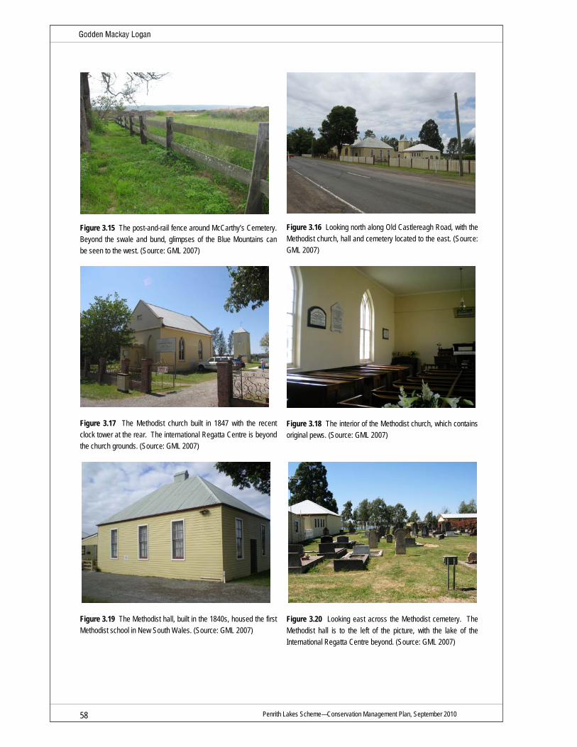
Penrith Lakes Scheme—Conservation Management Plan, September 2010 58
Figure 3.15 The post-and-rail fence around McCarthy’s Cemetery. Beyond the swale and bund, glimpses of the Blue Mountains can be seen to the west. (Source: GML 2007)
Figure 3.16 Looking north along Old Castlereagh Road, with the Methodist church, hall and cemetery located to the east. (Source: GML 2007)
Figure 3.17 The Methodist church built in 1847 with the recent clock tower at the rear. The international Regatta Centre is beyond the church grounds. (Source: GML 2007)
Figure 3.18 The interior of the Methodist church, which contains original pews. (Source: GML 2007)
Figure 3.19 The Methodist hall, built in the 1840s, housed the first Methodist school in New South Wales. (Source: GML 2007)
Figure 3.20 Looking east across the Methodist cemetery. The Methodist hall is to the left of the picture, with the lake of the International Regatta Centre beyond. (Source: GML 2007)

Penrith Lakes Scheme—Conservation Management Place, September 2010 59
Figure 3.21 Looking west across the Methodist cemetery towards the Upper Castlereagh schoolhouse and schoolmasters residence located on the other side of Old Castlereagh Road. (Source: GML 2007)
Figure 3.22 The Upper Castlereagh schoolhouse was designed by George Allen Mansfield and built in 1878 in the Gothic revival style. (Source: GML 2007)
Figure 3.23 A granite World War I memorial on the northern side of the Upper Castlereagh schoolhouse. The schoolmasters residence is located to the south of the schoolhouse. (Source: GML 2007)
Figure 3.24 Front facade of the schoolmasters residence, Upper Castlereagh. (Source: GML 2007)
Figure 3.25 View of the rear of the schoolhouse (left) and schoolmasters residence (right), Upper Castlereagh. (Source: GML 2007)
Figure 3.26 View of Nepean Park from the eastern boundary of the study area. (Source: GML 2007)

Penrith Lakes Scheme—Conservation Management Plan, September 2010 60
Figure 3.27 Nepean Park, built in 1822. (Source: GML 2007)
Figure 3.28 The entry drive to Hadley Park. The two-storey homestead is surrounded by a large garden and early outbuildings such as stables, sheds and a slab cottage. (Source: GML 2007)
Figure 3.29 Hadley Park, built c1811, features a distinctive jerkin-headed roof with a small timber escape hatch on the southern gable—a response to the frequent flooding experienced by early settlers. (Source: GML 2007)
Figure 3.30 An early nineteenth-century slab cottage, clad with corrugated-iron sheeting adjacent to Hadley Park homestead. (Source: GML 2007)
Figure 3.31 The immediate setting of Puddledock, located at 1268 Old Castlereagh Road, retains a rural character. (Source: GML 2007)
Figure 3.32 Puddledock is a rare slab and weatherboard cottage with a rear skillion roof addition. (Source: GML 2007)

Penrith Lakes Scheme—Conservation Management Place, September 2010 61
Figure 3.33 Fibro cottage adjacent to Puddledock, addressing Old Castlereagh Road. (Source: GML 2007)
Figure 3.34 View north along Old Castlereagh Road from Puddledock towards Landers Inn. (Source: GML 2007)
Figure 3.35 Landers Inn, originally constructed c1840–1860, with former stables in the foreground, located on Old Castlereagh Road. (Source: GML 2007)
Figure 3.36 The immediate setting of Landers Inn and stables retains its rural character. Landers Inn (right) and stables (left) still address Old Castlereagh Road. (Source: GML 2007)
Figure 3.37 The remnant fabric associated with Landers Inn is believed to be contained within a single-storey Californian bungalow. (Source: GML 2007)
Figure 3.38 A face-brick extension has been constructed to the rear of the house enclosing Landers Inn. (Source: GML 2007)

Penrith Lakes Scheme—Conservation Management Plan, September 2010 62
Figure 3.39 The remains of the former stables associated with Landers Inn. The sandstone structure remains structurally sound. (Source: GML 2007)
Figure 3.40 Holding pens located at the rear of the former stables. (Source: GML 2007)
Figure 3.41 View along Old Castlereagh Road, looking south from Landers Inn. Old Castlereagh Road is one of the earliest roads in the Penrith district and has historically been a dominant feature of the Scheme area.(Source: GML 2007)
Figure 3.42 Old Castlereagh Road runs parallel to the Blue Mountains and Nepean River. (Source: GML 2007)
Figure 3.43 View along Smith Road, looking east. Smith Road is located on the northernmost boundary of the Scheme area. (Source: GML 2007)
Figure 3.44 Entry drive to the mass concrete house, located in the Smith Road Conservation Area in the northern part of the Scheme area. (Source: GML 2007)

Penrith Lakes Scheme—Conservation Management Place, September 2010 63
Figure 3.45 The mass concrete house, located at 43 Smith Road, on approach from the entry drive. Its elevated position would have afforded views to many surrounding properties. Today, traditional visual connections remain with Landers Inn and Hadley Park. (Source: GML 2007)
Figure 3.46 Southern facade of the mass concrete house. The house was originally constructed in 1902. The rear wing is visible, extending west. (Source: GML 2007)
Figure 3.47 View of the Blue Mountains and the surrounding conservation area, looking west from the mass concrete house. (Source: GML 2007)
Figure 3.48 The rear of the mass concrete house comprises two wings connected by an internal courtyard. The roof has been removed. (Source: GML 2007)
Figure 3.49 Interior of one of the two rear wings of the mass concrete house. (Source: GML 2007)
Figure 3.50 Entry hall of the mass concrete house. (Source: GML 2007)

Penrith Lakes Scheme—Conservation Management Plan, September 2010 64
Figure 3.51 Interior of a front room of the mass concrete house. (Source: GML 2007)
Figure 3.52 Christ Church on Church Lane, built in 1878. It replaced the first Anglican church built in Old Castlereagh in 1813, which was lost to fire. Although this church is located outside of the study area it is a prominent visual element in the landscape, visible from various points within the Scheme area. (Source: GML 2007)

Penrith Lakes Scheme—Conservation Management Place, September 2010 65
Figure 3.53 Gradings of sensitivity to change for heritage sites at Penrith Lakes. This plan shows the original grant portions and the layout historic layout of the site. New development including landscaping, plantings and structures should be carefully sited to maintain or create axial vistas to distant sites and features. (Source: GML 2010)

Penrith Lakes Scheme—Conservation Management Plan, September 2010 66
3.7 Endnotes
1 Morris and Britton, Castlereagh Culturasl Landscape Study; Assessment and Recommendations, July 1999, p 62. 2 ibid p 30. 3 Carol Liston p 28. 4 Stedinger Associates July 2007, Assessment and Relocation Plan for the Cottage Puddledock, p 26. 5 Penrith City Council Library Service, Penrith City e-history, The Nepean River, viewed 23 November 2004,
http://www.penrithcity.nsw.gov.au/index.asp?id=223 6 See NSW Heritage Office, Heritage Terms and Abbreviations, p 6. Accessed on May 15 2008,
http://www.heritage.nsw.gov.au/docs/hm_terms&abbreviations.pdf

Penrith Lakes Scheme—Conservation Management Plan, September 2010 67
4.0 Assessment of Heritage Significance
4.1 Introduction The Penrith Lakes Scheme area has a layered history reflected in a variety of physical and intangible elements. It embodies a range of heritage values which vary in their levels of significance and in their tolerance for change.
This section assesses the heritage values of the site in order to establish a logical and practical framework for the ongoing management and conservation of those values. The following assessment considers the heritage values of the site as a whole, including its fabric, uses, associations and meanings, as well as its relationship to its immediate and wider settings. The Aboriginal significance of the site has not been assessed in this CMP, but is the subject of an Aboriginal Cultural Heritage Management Plan (ACHMP).
The remaining heritage items within and surrounding the Scheme area constitute the Penrith Lakes Group which forms a significant cultural landscape. The individual elements constituting the Penrith Lakes Group (sites, structures and their settings) deemed to have significant values have been assessed for the contribution that they make to the heritage values of the site as a whole. Whilst the elements are of significance in their own right, collectively they have the ability to constitute a broader range of meanings and values. As such, the various physical and intangible elements of the site should be regarded as a suite of related elements, rather than assessed or regarded in isolation. A more detailed discussion of the significance of the elements of the Penrith Lakes Group can be found in the Inventory of Individual Components in Section 7.0.
4.2 New South Wales Heritage Assessment Guidelines
4.2.1 Introduction
The NSW Heritage Manual guidelines, prepared by the former NSW Heritage Office and Department of Urban Affairs and Planning (as amended July 2003), provide the framework for the following assessment and statement of significance for the Penrith Lakes Scheme. These guidelines incorporate the five aspects of cultural heritage value identified in The Burra Charter: The Australia ICOMOS Charter for Places of Cultural Significance 1999 into a specially structured framework which is currently accepted as the required format by heritage authorities in New South Wales.
a) an item is important in the course, or pattern, of NSW’s cultural or natural history (or the cultural or natural history of the local area);
b) an item has strong or special association with the life or works of a person, or group of persons, of importance in the cultural or natural history of NSW (or the cultural or natural history of the local area);
c) an item is important in demonstrating aesthetic characteristics and/or a high degree of creative or technical achievement in NSW (or the local area);
d) an item has strong or special association with a particular community or cultural group in NSW (or the local area) for social, cultural or spiritual reasons;
e) an item has potential to yield information that will contribute to an understanding of NSW’s cultural or natural history (or the cultural or natural history of the local area);

Penrith Lakes Scheme—Conservation Management Plan, September 2010 68
f) an item possesses uncommon, rare or endangered aspects of NSW’s cultural or natural history (or the cultural or natural history of the local area);
g) an item is important in demonstrating the principal characteristics of a class of NSW’s:
– cultural or natural places; or
– cultural or natural environments
(or a class of the local area’s)
– cultural or natural places; or
– cultural or natural environments
In applying the criteria, both the nature and degree of significance for the place need to be identified, with items varying in the extent to which they embody or reflect key values and the relative importance of their evidence or associations.
The assessment also needs to relate the place’s values to its relevant geographical and social context at either the Local or State level. Items may be of both Local and State significance for similar or different values/criteria. Statutory protection of heritage places (that is, by local and/or state governments) is usually related to the identified level of significance. Places of State significance may be considered by the Heritage Council of NSW for inclusion on the State Heritage Register (SHR).
4.3 Heritage Assessment of Penrith Lakes The following assessment of the heritage significance of Penrith Lakes has been prepared in accordance with the criteria identified in the NSW Heritage Office guidelines. The evaluation includes consideration of the original and subsequent layering of fabric, uses, associations and meanings of the place, as well as its relationship to its immediate and wider settings.
4.3.1 Criterion A (Historic: Evolution)
An item is important in the course, or pattern, of NSW’s cultural or natural history (or the cultural or natural history of the local area)
Penrith Lakes is important as it reflects the earliest history of colonisation in New South Wales. This history was characterised initially by occupation by the Mulgoa and Boorooberongal clans of the Darug, European exploration and the expectation of friendly encounters or curious exchanges, but ultimately dispossession and alienation of Aboriginal people from their traditional country.
Penrith Lakes is of historical significance as a place of continual Aboriginal occupation, with archaeological evidence of a sustained Aboriginal presence dating back thousands of years. The area is a site of early contact with Aboriginal people having prior knowledge of European arrival at Port Jackson. It is a site of later conflict between Europeans and Aborigines. Penrith Lakes is significant in the development of the Australian colony as a military frontier settlement (officially begun in 1803) comprised of a mixture of emancipists, NSW Corps soldiers and free settlers.
Penrith Lakes contains layers of evidence from all phases of occupation from the early 1800s to the present including early road patterns and fencelines, continued agricultural production and escalating industrial development. The land grants found in Penrith Lakes were of a distinctively planned nature, surveyed in 1803 prior to their occupation, and allocated according to social status

Penrith Lakes Scheme—Conservation Management Plan, September 2010 69
and number of dependents (with the largest portions going to former soldiers who were married with children). The alignment of Old Castlereagh Road served as the basis of the early grants, which extended either side east to west. Extending from the north–south axis of Old Castlereagh Road, a network of fencelines and minor roads served to define grant boundaries and demonstrated the functional and spatial relationships between the grants. Old Castlereagh Road late came to be the main route to Richmond and is associated with the growth of Penrith.
The site contains evidence of the initial development and associations of a well established rural community centred around the churches and schools established by three neighbouring denominational groups. The farming community that developed here comprised a mix of tenant farmers and owners resulting in a distinctively diverse display of constructions, religious affiliations, landuses and interrelationships. Penrith Lakes is the site where Australia’s first Wesleyan church was established in 1817 and of one of the first identified Catholic burial grounds in McCarthy’s Cemetery.
Penrith Lakes is significant for the contribution it has made to the agricultural, mining and construction economies of New South Wales from the early 1800s to the present, through the cultivation of crops, orcharding, dairying, and both small and large sand and gravel extraction for use in construction.
4.3.2 Criterion B (Historic: Association)
An item has strong or special association with the life or works of a person, or group of persons, of importance in NSW’s cultural or natural history (or the cultural or natural history of the local area)
Penrith Lakes is significant as a place where local Aboriginal people have retained associations with their traditional country from which they were dispossessed during colonisation. Involvement of local Aboriginal people with the site has been ongoing, as demonstrated through oral history projects, the activities of the Muru Mittigar Aboriginal Cultural and Educational Centre, and Aboriginal archaeology projects.
Penrith Lakes retains historical associations with a range of individuals and groups of note who have, in various ways, influenced the development of the place. Officials (such as Governors King and Macquarie), early settlers and pastoralists (such as the McCarthys), clergy (such as Reverend Fulton), colonial builders, surveyors and architects (such as James Meehan and George Allen Mansfield) and artists and writers (such as Arthur Streeton, Elioth Gruner, Miles Franklin, Dame Mary Gilmore, and Charles Thomson)—each has left their mark on how the community has developed and been perceived. Many local families, such as the Singles, the Hadleys, and the Howells, share associations to the area and with each other through marriage, site tenancy or ownership and religious affiliations, as seen in family burials in McCarthy’s Cemetery and the Methodist cemetery.
Penrith Lakes is associated with the establishment of the Wesleyan (Methodist) Church in New South Wales and with the early colonial Catholic community, with some of the oldest representations of these two religions in New South Wales being present in the area, such as John Lees first Wesleyan chapel (c1815–20) and McCarthy’s Catholic cemetery. At the time of establishment of these religions in the area, both were considered outcast from the dominant religious affiliations of the colony and administration.
Penrith Lakes is associated with the establishment of sand and gravel mining in New South Wales from the 1880s and has witnessed its expansion and changing methods of operations. The direct

Penrith Lakes Scheme—Conservation Management Plan, September 2010 70
associations between the large mining companies such as Boral, Readymix and Pioneer and the community, includes both the acquisition of the land and later employment of the local labour force. Penrith Lakes is associated with the construction of Warragamba Dam in the 1950s, which utilised sand and gravel extracted from the site.
Penrith Lakes retains associations with the township of Castlereagh, established by Governor Macquarie in 1811, in response to concerns over the frequent flooding of the Nepean River affecting farmers and settlers on the floodplain. Although the township ultimately failed to lure farmers and settlers away from the fertile banks of the Nepean River and onto the elevated escarpment, visual links between Christ Church and various locations within the Scheme area represent an ongoing connection between the town of Castlereagh and Penrith Lakes.
4.3.3 Criterion C (Aesthetic Significance)
An item is important in demonstrating aesthetic characteristics and/or a high degree of creative or technical achievement in NSW (or the cultural or natural history of the local area)
Penrith Lakes has aesthetic significance as a distinctive landscape containing a striking combination of natural, rural and industrial features. The Penrith Lakes district includes an expansive floodplain set against the dramatic backdrop of the Nepean River and the Blue Mountains, the remnants of a rural farming landscape dotted throughout with a collection of colonial buildings and structures. The scenic qualities of Penrith Lakes have been captured in the works of a variety of artists including painters, poets, writers and film makers.
Within the Penrith Lakes area, a number of individual sites are of aesthetic significance. Nepean Park and Hadley Park are significant examples of substantially intact nineteenth-century homesteads, with Hadley Park including a distinctive jerkin roof form. Puddledock is an example of a rural vernacular architecture, displaying the simple form and scale of the wider farming community residences. The Methodist church and hall, and the Upper Castlereagh schoolhouse and schoolmasters residence are of aesthetic significance for their architectural merit both individually and as a grouping of nineteenth-century rural educational and religious buildings. McCarthy’s Cemetery has aesthetic significance as an example of a simple, dignified, rural nineteenth-century cemetery design and layout in an otherwise pastoral landscape.
The remarkable and severe landscape that has been created as a result of intensive quarrying at Penrith Lakes is also of some aesthetic significance as a human-made landscape.
4.3.4 Criterion D (Social Significance)
An item has strong or special association with a particular community or cultural group in NSW (or the local area) for social, cultural or spiritual reasons
Penrith Lakes is of social significance to the local Aboriginal community. The land is the traditional country of the Boorooberongal and the Mulgoa clans of the Darug. The river and associated landscape features, combined with the archaeological record, is of value to local Aboriginal people and demonstrated through their ongoing cultural connection to the place and the establishment of the Muru Mittigar Aboriginal Cultural Centre.
Penrith Lakes contains several heritage sites which are of social significance to the community within the Penrith district and more broadly because the community has strong personal associations to them; they provide a sense of identity linked to the past and are important places with specific features that historically distinguish the local area.

Penrith Lakes Scheme—Conservation Management Plan, September 2010 71
Penrith Lakes is of social significance to several prominent local families, some of whom can be traced directly to the original 1803 land grants in the area. The ongoing presence of the same family groups over successive generations, with continuing use of the land strongly connects family groups to the Castlereagh Valley. It remains one of Australia's oldest continuing rural communities.
Penrith Lakes contains sites which are of social significance to the agricultural and mining communities and to Sydney's religious communities, most notably the Methodist and Catholic churches, through examples of the long-enduring congregations and cemeteries in Australia.
Penrith Lakes is of social significance to the Nepean District Historical Archaeological Group (NDHAG). The group has been associated with the history and heritage of the Castlereagh Valley since the mid 1980s. During that time NDHAG members have undertaken historical research, participated in a number of archaeological excavations and prepared reports for many of the heritage sites within the Penrith Lakes Scheme area. The group has a collection of artefacts and an historical and photographic archive related to the area and members continue to dedicate many hours as volunteers to the management of the collections and promoting its history and heritage.
The Castlereagh Valley is also valued by other groups such as the National Trust (Parramatta Branch) and the Nepean District Historical Society who regularly tour heritage places, organise commemorative events and are active participants in community consultation related to heritage within the Scheme area. Oral history studies conducted in the area in 1998, coupled with public protest and media coverage of the Penrith Lakes Development Scheme demonstrate the ongoing social attachment and value of the area to the local community.
Loss is a significant aspect of the social value of Penrith Lakes. For many who lived and worked in the valley there is a complexity and depth of feeling associated with the place that is part of their sense of self-identity, wellbeing and belonging. There is a process of transition as the community continues to grieve and accept change.
4.3.5 Criterion E (Research Potential)
An item has potential to yield information that will contribute to an understanding of NSW’s cultural or natural history (or the cultural or natural history of the local area)
Penrith Lakes is significant for its research potential, containing historical fabric that has the ability to further understanding of the early settlement and subsequent development of the district and the way of life of those who lived and worked here. The surviving fabric at Penrith Lakes, including the architectural styles and construction techniques of surviving structures, the potential archaeological resource, the cemeteries, the evidence of amalgamation and subdivision of properties and the linkages between individual and collective sites presents an opportunity to reveal new insights into the social, economic, religious, and demographic composition and organisation of a colonial rural community of the frontier of the larger European settlement. The area has research potential as an isolated colonial settlement that allowed for a relatively insular community to grow outside the main development in the area. It provides a major research, educational and interpretive resource.
Penrith Lakes has the potential to contribute to our knowledge of:
• the nature and extent of Aboriginal occupation in the area prior to European settlement;
• post-contact relations between local Aboriginal groups and European settlers;
• the response of early settlers to the landscape, specifically to the threat of flooding;

Penrith Lakes Scheme—Conservation Management Plan, September 2010 72
• the selection and administration of early land grants;
• the nature and extent of the use of convict labour in the development of the area;
• the practice and extent of small scale tenant farming in the area and the contribution this made to the agricultural development of the district;
• the success and failure of planned official towns such as Castlereagh;
• the development of sand and gravel mining; and
• the development of local construction methods (such as the early use of mass concrete).
4.3.6 Criterion F (Rarity)
An item possesses uncommon, rare or endangered aspects of NSW’s cultural or natural history (or the cultural or natural history of the local area)
Penrith Lakes comprises a rare cultural landscape where significant layered historical associations and meanings remain intact, in forms that are both tangible and intangible. Penrith Lakes is rare as a place where close religious and familial ties have continued over two hundred years of settlement dating back to some of the earliest land grants made in Australia.
Penrith Lakes contains some of the earliest surviving and rarest historical fabric in Australia, including built structures and archaeological and landscape features such as:
• Hadley Park, built in 1811, which is considered to be the oldest building in the Nepean Valley. It is a rare example within Penrith Lakes of a large intact Georgian homestead with surviving outbuildings, including a slab cottage possibly predating the homestead, and thus is believed to be the oldest timber structure in the country.
• McCarthy’s Cemetery is rare as one of the oldest surviving Catholic cemeteries in Australia.
• Landers Inn may be a rare, if not unique example of a nineteenth-century inn (with associated stables) that is believed to have been incorporated into a twentieth-century residence.
• Puddledock is a rare reconstructed surviving example of the vernacular construction techniques that would have once been common to the area in the early twentieth century.
• The Upper Castlereagh group, comprising the Methodist church and hall, the Methodist cemetery, schoolhouse and schoolmasters residence is a rare example of an intact nineteenth century grouping of rural civic buildings.
• The hall associated with the Methodist church is rare as the site of the first Wesleyan school in Australia, established in 1864.
• The Poplars contains the remains of early slab structures and rare exotic plantings associated with the Royal Botanic Garden.
• Early road alignments (including Old Castlereagh Road and McCarthys Lane) and fencelines indicating the boundaries of original land grants dating from 1803.

Penrith Lakes Scheme—Conservation Management Plan, September 2010 73
• Jackson’s Ford is rare as the only surviving nineteenth-century river crossing within Penrith Lakes, and possibly within Castlereagh, providing enduring evidence of early stock routes.
• The remains of the gravel plant are rare as the only visible remains of an early twentieth-century mill on this site, once common along the Nepean River.
Penrith Lakes contains rare and endangered species of flora and fauna (remnants of grey box-ironbark woodland and river-flat forest).
4.3.7 Criterion G (Representativeness)
An item is important in demonstrating the principal characteristics of a class of NSW’s cultural or natural places or cultural or natural environments (or a class of the local area’s cultural or natural places; or cultural or natural environments)
The settlement of Penrith Lakes, following the colonial land grants of 1803, and the subsequent establishment of a small but self sufficient farming community, is representative of early nineteenth-century development in the Nepean district. The farming activities carried out here, such as the growing of crops, orcharding and later dairying are representative of the agricultural development of the region and greater New South Wales. The strong affiliations between the community that was established at Penrith Lakes and the Methodist (Wesleyan), Catholic and Anglican denominations are representative of the place that religion occupied in the organisation and administration of nineteenth-century society in Australia.
Penrith Lakes contains representative examples of early nineteenth-century buildings, including Georgian homesteads at Nepean Park and Hadley Park, and the collection of modest Gothic buildings at Upper Castlereagh comprising the Methodist church and hall and Upper Castlereagh schoolhouse. Although their scale is uncommon in Penrith Lakes, the two-storey homesteads at Nepean Park and Hadley Park are representative of the threat of flooding that faced the settlers of Penrith Lakes, and a particular response to this.
Penrith Lakes contains representative examples of the simple single-storey timber dwellings commonly occupied by tenant farmers, such as Puddledock, and the slab cottages at The Poplars and Hadley Park. McCarthy’s Cemetery and the Methodist cemetery are representative of nineteenth-century cemetery design and layout, and the evidence of nineteenth-century mills and sand and gravel extraction along the Nepean River operating on this site are representative of the industrial evolution of the site and the wider area.
Some remaining fencelines and early road and laneways demonstrate the original allocation, organisation and administration of nineteenth-century land grants. Old Castlereagh Road is representative of road formation in the early nineteenth-century and the network of minor access roads, such as McCarthys Lane, is representative of the functional use of the surrounding land grants.
4.3.8 Aboriginal Archaeology
The Aboriginal archaeological resource of the Penrith Lakes Scheme is of significance. The information gained from the area can contribute towards a greater understanding of local occupation trends and lifestyles. Such information can contribute to the body of knowledge about regional occupation patterns of the Cumberland Plain as well as pre- and post-contact Aboriginal activities and exchanges and interactions with settlers.
Penrith Lakes Scheme—Conservation Management Plan, September 2010 74
Two areas of Aboriginal archaeological significance have been established as conservation areas:
• Smith Street Conservation Area; and
• Vincent Creek Conservation Area.
In addition, the following conservation areas also contain Aboriginal heritage significance:
• Hadley and Nepean Parks. This area was established to conserve significant European historical cultural heritage. However, it does contain one known Aboriginal site (PL12); and
• escarpment (on the northeastern boundary of the Scheme). This area contains a known Aboriginal site (PL11) and the area is significant to the Aboriginal community for cultural reasons.
The Aboriginal archaeological resource of Penrith Lakes is addressed in greater detail in the Aboriginal Cultural Heritage Management Plan (ACHMP).
4.4 Statement of Significance Penrith Lakes includes the remnants of what was a formally a substantially intact rural colonial landscape of a significantly large scale. While the diminution of integrity of this historically significant rural landscape and the progressive loss of the vast majority of individual heritage sites has negatively impacted on this cultural landscape, the significance of what remains at this site has been elevated due to its rarity.
Penrith Lakes is significant as the traditional country of the Darug Aboriginal people. It is a site of early recorded cultural observation, of cultural exchange and conflict, between Aboriginal and non-Aboriginal people. The site includes significant Aboriginal archaeological evidence that provides an important record of Aboriginal occupation and use of natural resources prior to European settlement. Penrith Lakes is of significance to the local Aboriginal community, the community value the remnant archaeological record associated with the place as it provides physical evidence of their ancestor’s presence. Today local Darug people maintain their cultural connections to the site and are actively engaged in promoting the Aboriginal cultural heritage of Penrith Lakes through Muru Mittigar.
As one of the earliest rural frontier settlements in the colony, with land grants to NSW Corps soldiers, convicts and free settlers, it retains evidence of the various phases of non-Aboriginal occupation from the early 1800s, agricultural production and escalating industrial development.
Penrith Lakes is significant as the home of a small but well-established farming community which began following official land grants in 1803. It is one of Australia's oldest continuing rural communities. The community comprised a close-knit network based on religious and familial ties, many of which continued over two hundred years. The ongoing presence of the same family groups over successive generations, with continuing use of the land, has engendered a strong sense of social significance and an enduring attachment to the landscape.
Penrith Lakes contains some of Australia’s earliest surviving and rare historical fabric, including built structures, archaeological resources and landscape features, which individually are highly significant, but collectively represent a historical resource of exceptional significance. It comprises a unique cultural landscape where a significant layering of historical associations, meanings and
Penrith Lakes Scheme—Conservation Management Plan, September 2010 75
values remain intact, in forms that are both tangible and intangible, despite the diminished physical integrity of the broader setting.
Local historical groups including the Penrith District Historical Society, the Nepean District Historical Archaeological Group and the National Trust (Parramatta Branch) value the history and heritage associated with the place. Public opposition to quarrying demonstrates the community’s strong emotional attachment and sense of loss associated with the development of the site.
Penrith Lakes is significant for its associations with early settlers, the establishment of the Wesleyan (Methodist) Church, the establishment of the township of Castlereagh in 1810 which was one of Governor Macquaire’s five towns, and the establishment of sand and gravel mining in New South Wales from the 1880s. It has made a significant contribution to the agricultural, mining and construction economies of New South Wales through the cultivation of crops, orcharding, dairying, and small and large scale sand and gravel extraction.
Penrith Lakes is a distinctive landscape of aesthetic significance. The scenic qualities of Penrith Lakes have been captured in the works of various artists including painters, poets, writers and film makers.
Penrith Lakes is significant for its research potential, containing some substantially intact, rare historical fabric that has the potential to yield further information about the early settlement and subsequent development of the district, and the way of life of those who lived and worked here. The surviving fabric at Penrith Lakes, such as the potential archaeological resource, the cemeteries, the architectural styles and construction techniques of surviving structures, the evidence of amalgamation and subdivision of properties and the linkages between individual and collective sites has the potential to reveal a great deal about the social, economic, religious, and demographic composition and organisation of this small rural farming community. It provides a major research, educational and interpretive resource.

Penrith Lakes Scheme—Conservation Management Plan, September 2010 76

Penrith Lakes Scheme—Conservation Management Plan, September 2010 77
5.0 Key Considerations
5.1 Introduction This section of the report outlines the major issues and key considerations relating to the conservation and management of the Penrith Lakes Scheme and its future development. It takes into consideration matters arising from the statement of significance and the requirements arising from all statutory and non-statutory listings that apply to the site.
In order to develop conservation policies that ensure cultural significance is appropriately maintained, enhanced and interpreted and to provide specific guidelines for the conservation, ongoing care, development and future use of heritage sites at Penrith Lakes, a range of issues need to be considered. They are generally divided into the following categories:
• the constraints on and opportunities for use and development of the site arising from the statement of significance;
• the requirements of the site users and owners, available resources and appropriate uses;
• the physical condition and degree of integrity of the place’s fabric; and
• requirements imposed by external factors and agencies including statutory obligations.
5.1.1 Guiding Principles
The future conservation and development of the place should be carried out in accordance with the principles of The Burra Charter: The Australia ICOMOS Charter for Places of Cultural Significance 1999, particularly the following articles:
• Cultural significance means aesthetic, historic, scientific, social or spiritual value for past, present or future generations. Cultural significance is embodied in the place itself, its fabric, setting, use, associations, meanings, records, related places and related objects. (Article 1.2, Burra Charter)
• Conservation is based on a respect for the existing fabric, uses, associations and meanings. It requires a cautious approach of changing as much as necessary but as little as possible. (Article 3.1, Burra Charter)
• A place should have a compatible use. (Article 5.2, Burra Charter)
• Conservation requires the retention of an appropriate visual setting and other relationships that contribute to the cultural significance of the place. New construction, demolition, intrusions or other changes which would adversely affect the setting or relationship are not appropriate. (Article 8, Burra Charter)
Following from these principles, adverse impacts on components, fabric or other aspects of significance including use should only be permitted where:
• it makes possible the recovery of aspects of greater significance;
• it helps ensure the security and viability of the place;
• there is no feasible alternative (eg to meet safety and/or legal requirements);

Penrith Lakes Scheme—Conservation Management Plan, September 2010 78
• the area, element, fabric or other aspect of significance is adequately recorded; and
• full assessment of alternative options has been undertaken to minimise adverse impacts.
5.2 Key Considerations Arising from Significance The future conservation, development and ongoing management of the Penrith Lakes Scheme should have regard to the identified heritage significance of the site, its setting and its components.
Opportunities to retain, enhance and interpret the heritage values of Penrith Lakes should be considered as integral to the overall sustainability and viability of the Penrith Lakes Scheme.
The following key considerations arise from the assessed significance of the site as a whole:
• The non-Aboriginal cultural heritage of the Penrith Lakes Scheme must be managed and in conjunction with the natural heritage and Aboriginal cultural heritage values of the site.
• The Penrith Lakes Scheme area is culturally significant to local Aboriginal people for it includes evidence of past occupation. The community have continuing connections to country and the Scheme area provides opportunities for Aboriginal people to share their knowledge and promote Aboriginal cultural heritage to the public.
• The cultural landscape of the Penrith Lakes Scheme area includes built elements, roads, fencelines, plantings, historic viewlines to and from heritage sites within and outside of the Scheme area, movable collections and potential archaeological evidence. Collectively, these physical elements and the range of significant social meanings and values constitute the place and its cultural significance. The surviving elements should be regarded as constituting a cultural landscape, and though parts of the landform have been transformed, it still has the ability to demonstrate significant cultural values.
• The interrelationships between surviving elements comprise the cultural landscape including the relationships between the remaining historic properties like Hadley Park, Nepean Park, Landers Inn and other places such as McCarthy’s Cemetery, Macquarie’s township of Castlereagh, the Methodist church and church hall, Upper Castlereagh School and schoolmaster’s residence.
• The Penrith Lakes Scheme contains items of State and Local heritage significance which should be conserved and managed in accordance with accepted conservation principles and practice.
• Government authorities with an interest in the conservation of the heritage values of Penrith Lakes include Penrith City Council, the Heritage Branch of the Department of Planning, the New South Wales Department of the Environment, Climate Change and Water, and the Commonwealth Department of the Environment, Water, Heritage and the Arts.
• Penrith Lakes is of strong social significance to a range of individuals and groups, retaining personal and historic associations with Aboriginal people, local families and descendents of early settlers, religious communities, agricultural and mining communities, all of whom have a particular interest in the future of the site.
• The heritage values of the Penrith Lakes Scheme must be interpreted for the general public.

Penrith Lakes Scheme—Conservation Management Plan, September 2010 79
• The conservation and interpretation of the cultural heritage values of Penrith Lakes will provide educational, tourism and investment opportunities.
• Experienced heritage specialists should plan, supervise and direct conservation projects and works in accordance with Burra Charter principles and the policies contained in this CMP.
• Decisions about new development, maintenance, repairs or more extensive adaptation works must always take into account any potential impact on the cultural heritage significance of the place, both as a whole and on individual components.
• The future conservation and development of the place should follow the policies set out in Section 6.0 of this report which have been developed to ensure the appropriate management of the place’s heritage values.
5.3 Key Considerations Arising from Condition and Integrity The overall condition and integrity of the cultural landscape of the Penrith Lakes Scheme area has been assessed as poor. However, the condition and integrity of individual sites and elements within the Scheme area varies (see Section 7.0).
The following considerations relate to the physical condition of the site overall:
Heritage Items and Cultural Landscape
• Penrith Lakes contains some of the earliest surviving and rarest historic fabric in Australia. The fragility of some fabric, such as the Hadley Park homestead and McCarthy’s Cemetery, will restrict the way in which these sites are used and interpreted.
• The settings of many of the surviving and intact sites of heritage significance have been severely compromised by mining. This places greater significance on existing views between remaining sites.
• Surviving historic fabric, existing viewlines between heritage places and individual elements within the Scheme area and their settings are rare and sensitive to change.
• Urgent maintenance and restoration of individual elements and sites is required. A detailed prioritised schedule of works should be prepared for heritage sites and immediate action taken to ensure no further loss of original fabric.
• There are opportunities to interpret the original alignment of Old Castlereagh Road.
• Adequate security of significant heritage sites within the Scheme area should be maintained to prevent vandalism and further deterioration.
Natural Landscape
• Locally indigenous vegetation, particularly Cumberland Plain woodland species, must be conserved. Opportunities exist to reinstate indigenous vegetation.
• Some disused quarries have been filled with water creating reservoirs and lakes and as part of the development of the Scheme it is proposed to adapt these to enhance visual amenity and create recreational waterways or to develop wetland conservation areas. The water quality of any lakes will be subject to ongoing monitoring.

Penrith Lakes Scheme—Conservation Management Plan, September 2010 80
• Extensive soil remediation will be required for those areas of the site that have been mined resulting in the loss of an appropriate soil structure.
• Management of noxious weeds is required, particularly along the riparian corridor.
• The site is located on a floodplain which is subject to periodic flooding of the Nepean River. As such any new development will need to manage the potential flood risk in accordance with the state government’s Flood Prone Land Policy.
5.4 Owner Requirements and Future Uses Finding viable and sustainable future uses for the site is integral to the protection, conservation and interpretation of its cultural and natural heritage significance.
Penrith Lakes holds potential for integrated mixed-use residential and commercial development incorporating natural and cultural heritage conservation areas, tourism and recreational uses including:
• heritage trails;
• walking trails;
• cycleways;
• equestrian trails;
• an aquatic centre/water parks;
• public parks;
• core conservation areas for biodiversity protection;
• corridors of natural vegetation linked to core conservation areas;
• rehabilitation and conservation of riverbank and escarpment vegetation;
• landscape mosaics for different vegetation communities;
• heritage museum (including house museums) operated by a heritage trust in association with an organisation such as the Historic Houses Trust or National Trust (NSW);
• interpretation/visitors centre;
• artists/writers/composers in residence programs in association with local arts organisations;
• community facilities (such as schools, day-care centres);
• educational programs in conjunction with the Penrith Lakes Environmental Education Centre incorporating flora and fauna regeneration, the implementation of cultural heritage management and conservation and community involvement in archaeological investigation and monitoring;
• events, festivals and open days for heritage sites such as Hadley Park and The Poplars; and

Penrith Lakes Scheme—Conservation Management Plan, September 2010 81
• Cultural Centres, for example, Muru Mittigar.
The following considerations relate to the potential future use of Penrith Lakes:
• Some sites such as Hadley Park and The Poplars are currently vacant.
• Hadley Park is a highly significant site. Due to the rarity and significance of the original fabric as well as the scale and liveability of the house re-use of the house is limited.
• Nepean Park, the Methodist church group, the school and schoolmaster’s residence and the Poplars are not in PLDC ownership.
• Some sites will require significant conservation works and catch-up maintenance in order for adaptive re-use to occur. Such works will require the involvement of heritage specialists.
• Future use of the site should have regard to the identified significance and policies of the site contained in this CMP.
• Sites such as Landers Inn, Hadley Park and McCarthy’s cemetery an have had individual CMPs prepared for them (or are being finalised). Any future use should have regard to these.
• Individuals and community groups should be provided with opportunities for participation and/or consultation in planning future uses.
• New development should respect the settings of heritage places and the cultural landscape of the site, including significant historic views and vistas.
5.5 Deed of Agreement and Conditions of Development Consent The PLDC is presently carrying out quarrying operations subject to certain heritage obligations contained in the Deed of Agreement entered into with the State Government of New South Wales. Additionally, the quarrying operations are being carried out subject to conditions attached to a range of development consents. These conditions require the PLDC to manage the potential archaeological resource and certain elements of built heritage through the preparation of CMPs, archival recording and other processes. The recommendations of this CMP (and the AMP also prepared by Godden Mackay Logan in 2010) together reflect the obligations imposed by those conditions of consent and the Deed of Agreement.
5.6 Statutory Requirements This section includes an overview of Commonwealth and state legislation that is applicable to Penrith Lakes. The Minister for Planning has determined under clause 6 of State Environmental Planning Policy (Major Projects) 2005 (MP SEPP) that Penrith Lakes is subject to Part 3A of the Environmental Planning and Assessment Act 1979 (NSW) (EP&A Act). A Part 3A project is development for the purpose of residential, commercial or retail projects with a capital investment value of more than $50 million that the minister determines are important in achieving state or regional planning objectives. Requirements for approvals under other acts do not apply because the Minister for Planning is the consent authority. At some stage in the future the minister may devolve the approvals role back to local government once the planning issues of strategic importance to the state have been resolved.
Penrith Lakes Scheme—Conservation Management Plan, September 2010 82
5.6.1 Environmental Protection and Biodiversity Conservation Act 1999
The Environmental Protection and Biodiversity Conservation Act 1999 (NSW) (EPBC Act) protects the environment, including places of natural and cultural value, by preventing actions that are likely to have a significant negative impact.
The EPBC Act gives effect to the Convention for the Protection of the World Cultural and Natural Heritage, Paris, 1972, protecting World Heritage values of places listed on the World Heritage List (WHL). This is relevant to the management of the Penrith Lakes Scheme as the Scheme area abuts the World Heritage listed Blue Mountains. As such, proposed development within the Scheme area may be assessed by the Australian Heritage Council to determine its potential to have a significant negative impact on the World Heritage values of the Blue Mountains.
The EPBC Act also protects places of Commonwealth and National Heritage value through the Commonwealth Heritage List (CHL) and National Heritage List (NHL). Commonwealth Heritage values and National Heritage values are determined by applying a number of criteria contained in the Environment Protection and Biodiversity Conservation Regulations 2000. Places owned or controlled by the Commonwealth that satisfy one or more of the listed criteria are listed on the CHL. The NHL lists items of exceptional significance to the nation whether or not they are owned and controlled by the Commonwealth. If a place satisfies the required criteria, it is possible that it could be listed on both the CHL and the NHL.
Once a place is listed on the CHL and/or the NHL it must be managed according to a number of heritage principles contained in the Act and its Regulations. The Penrith Lakes Scheme and the heritage places it contains are not listed on either the CHL or NHL.
The EPBC Act also lists and protects threatened species and ecological communities. The Penrith Lakes Scheme contains remnants of Cumberland Plain woodland which is listed as an Endangered Ecological Community under the EPBC Act.
Register of the National Estate
The Register of the National Estate (RNE) has been retained as an indicator of heritage values and is kept by the Australian Heritage Council (AHC). It lists items that are:
Components of the natural environment or the cultural environment of Australia that have aesthetic, historic, scientific or social significance, or other special value for future generations, as well as for the present community.
Recent amendments to the Act mean that the Register of the National Estate (RNE) ceases to operate as a statutory heritage list in February 2012. Nepean Park, the Methodist church, hall and cemetery are listed on the RNE (see Appendix D).
The listing of a place as a registered item on the RNE has some effect on the registered item, principally with respect to certain actions of the Commonwealth Government and its departments and authorities. Section 391A of the EPBC Act requires that any decision made under the Act must have regard to the listing of an affected place on the RNE. The EPBC Act also specifically states that a place on the RNE is included in the definition of ‘environment’. Therefore the heritage values addressed in the RNE listing for the heritage sites mentioned above will still place some obligations on the owner under the EPBC Act.
The Commonwealth Minister for the Environment and Heritage must also consider the listing of an item on the RNE when making a determination under the EPBC Act. Amendments to the EPBC Act

Penrith Lakes Scheme—Conservation Management Plan, September 2010 83
have extended the protections previously afforded by the Act to the natural environment to elements of Australia's cultural heritage.
5.6.2 Disability Discrimination Act 1992
Disability Discrimination Act 1992
Although the BCA deals with the requirements for access to premises for people with disabilities, compliance with the BCA does not signify compliance with the Disability Discrimination Act 1992 (Cwlth) (DDA).
The DDA is a Commonwealth act that requires that all public buildings be accessible to people with disabilities. The DDA makes it unlawful to discriminate against people with disabilities and aims to remove the direct and indirect barriers preventing equal opportunities for disabled persons and thus their full participation in the community. The DDA applies a broad definition to the term ‘disability’, to include physical and intellectual disabilities as well as mental illnesses.
The DDA relates to the provision of goods and services, access to facilities and physical access to public places. Section 23 of the DDA states that failing to provide disabled access is not considered unlawful if:
the premises are so designed or constructed as to be inaccessible to a person with a disability; and
any alteration to the premises to provide such access would impose unjustifiable hardship on the person who would have to provide that access.
‘Unjustifiable hardships’ in complying with the requirements of the BCA and the DDA may include financial burden as well as adverse heritage impacts. If strict adherence to these requirements were likely to cause adverse heritage impacts to significant fabric, then alternative means of meeting the objectives of the codes/legislation should be investigated. (In these cases, specialist input could be sought from the Heritage Council Fire, Access and Services Advisory Panel (FASAP).)
5.6.3 New South Wales Threatened Species Conservation Act 1995
The objects of the Threatened Species Conservation Act 1995 (NSW) are:
(a) to conserve biological diversity and promote ecologically sustainable development, and
(b) to prevent the extinction and promote the recovery of threatened species, populations and ecological communities, and
(c) to protect the critical habitat of those threatened species, populations and ecological communities that are endangered, and
(d) to eliminate or manage certain processes that threaten the survival or evolutionary development of threatened species, populations and ecological communities, and
(e) to ensure that the impact of any action affecting threatened species, populations and ecological communities is properly assessed, and
(f) to encourage the conservation of threatened species, populations and ecological communities by the adoption of measures involving co-operative management.
The Threatened Species Conservation Act 1995 (NSW) (TSC Act) protects threatened plant and animal species and their habitats native to New South Wales (with the exception of fish and marine plants). The Act encourages conservation and prevents extinction of threatened species through the listing of threatened species and providing for the elimination or management of threatening

Penrith Lakes Scheme—Conservation Management Plan, September 2010 84
processes (as defined in Schedule 3). Included as a threatening process is the alteration to the natural flow regimes of rivers and streams and their floodplains and wetlands, and the presence of feral animals (such as cats). As such, under the TSC Act, any proposed development within the Scheme area must have regard to the impacts of landuses and development on the Nepean River and floodplain. The Act also requires the elimination or management of feral animals.
Remnants of Cumberland Plain woodland and Sydney coastal river flat forest that exist in the Scheme area are listed as a threatened ecological community under Schedule 1, Part 2 of the Act. As such, the Act requires that the impact of any development proposed within the Scheme area on these threatened species is assessed prior to determination. All listed species and ecological communities listed under this Act are also offered protection under the EPBC Act.
5.6.4 Heritage Act 1977 (NSW)
State Heritage Register
Sites or relics that are listed on the New South Wales State Heritage Register (SHR) or that are subject to a Permanent Conservation Order are provided statutory protection under the Heritage Act 1977 (NSW). Presently only the Upper Castlereagh School and residence is listed on the SHR (see Appendix B). Pursuant to Section 57(1) of the Act, the approval of the Heritage Council of NSW is required for any proposed development within sites listed on the SHR, including subdivision, works to the grounds or structures or disturbance of archaeological ‘relics’. Unless an item constitutes a danger to its occupants or the public, demolition of a listed item is prohibited.
To gain approval for works to alter, damage, demolish, move or carry out development on land on which a listed building, work or relic is located, an application must be made to the Heritage Council (Section 60 application). Section 60 application forms are available from the Heritage Branch of the New South Wales Department of Planning. These generally need to be accompanied by a Conservation Management Plan (CMP), particularly for large and/or complex sites and/or where a significant level of development is proposed. A Heritage Impact Statement (HIS) is also usually required, setting out the impacts of the proposed development on the significance of the place and consistency of the proposal with the CMP or other relevant documents.
Exemptions
Section 57(2) of the Heritage Act provides for a number of Exemptions to Section 57(1) approval requirements. Exempt development does not require prior Heritage Council approval. There are two types of Exemptions: Standard and Specific.
Standard Exemptions apply to all items on the SHR and generally include minor and non-intrusive works and are in some instances subject to some qualifications. Typical exempted works include maintenance (to buildings and gardens), minor repairs and repainting in approved colours.
Specific exemptions apply only to an individual State Heritage Register item and are gazetted and included on the SHR listing, or identified in a CMP for the item endorsed by the Heritage Council. There are currently no site-specific exemptions for the Upper Castlereagh School.
• Exemptions do not apply to the disturbance, destruction, removal or exposure of archaeological ‘relics’.
Penrith Lakes Scheme—Conservation Management Plan, September 2010 85
Archaeological Relics
‘Relics’ are defined by the Heritage Act to mean:
any deposit, artefact, object or material evidence that: (a) relates to the settlement of the area that comprises New South Wales, not being Aboriginal settlement, and (b) is of State or local heritage significance.
Under Section 139 a person must not disturb or excavate any land knowing or having reasonable cause to suspect that the disturbance or excavation will or is likely to result in a relic being discovered, exposed, moved, damaged or destroyed unless carried out in accordance with an excavation permit. Should a relic be discovered or located, regardless of whether an excavation permit has been issued, the Heritage Council must be informed.
The Penrith Lakes Archaeological Management Plan contains detailed assessments of the archaeological sensitivity and significance of the Scheme area.
Exceptions
Under Section 139 (4) the Heritage Council may permit an exception to the requirement of an excavation permit, subject to conditions.
Minimum Standards of Maintenance and Repair
Section 118 of the Heritage Act provides for the regulation of minimum standards for the maintenance and repair of State Heritage Register items. These standards were regulated in 1999 and apply to all State Heritage Register items. The minimum standards cover the following areas:
• weatherproofing;
• fire protection;
• security; and
• essential maintenance.
An inspection to ensure that the item is being managed in accordance with the minimum standards must be conducted at least once every year (or at least once every three years for essential maintenance and repair standards).
Failure to meet the minimum standards may result in an order from the Heritage Council to do or refrain from doing any works necessary to ensure the standards are met. Failure to comply with an order can result in the resumption of land, a prohibition on development, or fines and imprisonment.
5.6.5 Environmental Planning and Assessment Act 1979
The Environmental Planning and Assessment Act 1979 (EPA Act) outlines the processes by which development is determined defining types of development, consent authorities, environmental planning instruments (EPIs) and the processes for assessing development applications. Under the EPA Act the environmental impacts of development, including impacts on natural and cultural heritage, must be assessed when determining a development application. Part 1, Section 5A specifies the factors which must be taken into account by a consent authority when determining an application that has the potential to have a significant effect on threatened species, populations or ecological communities, or their habitats.

Penrith Lakes Scheme—Conservation Management Plan, September 2010 86
5.6.6 State Environmental Planning Policy (Major Projects) 2005
Penrith Lakes is included in Schedule 2 as a Part 3A project under the SEPP (Major Projects) 2005. The schedule applies to development at Penrith Lakes identified for the purpose of extraction, rehabilitation or lake formation (including associated infrastructure located in or outside that area).
The future development of the Scheme area does constitute a major project under Part 3A of the EPA Act. Therefore, the Minister for Planning is the relevant consent authority. The minister may consult with other relevant authorities (such as the Heritage Branch of the New South Wales Department of Planning) in making a determination on such things as adverse heritage impacts. However, the provisions of the relevant statutes do not apply. Once the minister is satisfied that the state’s strategic planning objectives have been met, the role of consent authority may be devolved back to local government.
An application under Part 3A must be supported by an environmental assessment that identifies any adverse impacts. This includes adverse impacts on heritage places. The environmental assessment is a public document and anyone can make a submission to the minister for or against a proposed development. The minister may refuse an application on the grounds that it will result in unacceptable adverse heritage impacts. The minister will carefully consider any submission made by the Heritage Branch in this regard.
5.6.7 State Environmental Planning Policy No. 55—Remediation of Land
SEPP No. 55 provides an approach to the remediation of contaminated land in New South Wales under the EPA Act by requiring planning authorities to consider whether and to what extent land that is the subject of a development application is contaminated. It specifies when consent is required for remediation works and sets out standards and requirements to ensure that land is suitably remediated for the purposes for which the development is proposed to be carried out.
Under Section 9 of the Act, the remediation of land within the Scheme area for the purposes of development would require consent from the relevant development consent authority. Section 17 of SEPP No. 55 states that remediation must be carried out in accordance with guidelines in force under the Contaminated Land Management Act 1997. The application of Part 3A turns these approval requirements off.
5.6.8 Sydney Regional Environmental Plan 11
The Penrith Lakes Scheme development is implemented under the provisions of the Sydney Regional Environmental Plan 11—Penrith Lakes Scheme (SREP 11). SREP 11, gazetted in 1986, was preceded by a Regional Environmental Study (RES) which identified the creation of lakes and urban and parkland areas as the preferred means for rehabilitating the site following the completion of sand and gravel extraction (see Appendix A). Under the SREP the minister for Planning is the consent authority for extraction, rehabilitation or lake formation. For all other approvals the consent authority is Penrith City Council.
SREP 11 provides development control processes establishing environmental and technical matters which must be taken into account in implementing the Penrith Lakes Scheme. These include the identification and protection of items of natural and cultural heritage.
The following items within the Penrith Lakes Scheme are listed as heritage items in Schedule 3 of SREP 11—Penrith Lakes Scheme:
Penrith Lakes Scheme—Conservation Management Plan, September 2010 87
• Hadley Park (Lots 1 and 2, MPOS (OS) 8807);
• Nepean Park (Portion 48);
• McCarthy’s Cemetery (part Portion 82);
• Upper Castlereagh Methodist church and hall (part Portion 71);
• Upper Castlereagh School and residence (part Portion 54); and
• Methodist cemetery, (part Portion 71).
5.6.9 The National Parks and Wildlife Act, 1974.
The National Parks and Wildlife Act 1974 (NSW) (NPW Act) is the primary legislative framework for the protection and management of Aboriginal heritage in New South Wales. While the assessment of Aboriginal heritage is beyond the scope of this report, the NPW Act is relevant to the Scheme area due to the presence of identified sites of Aboriginal significance.
Under this Act an Aboriginal artefact refers to any deposit, object or material evidence (not being a handicraft made for sale) relating to Aboriginal habitation of the area that comprises New South Wales, being habitation before or concurrent with (or both) the occupation of that area by persons of non-Aboriginal extraction, and includes Aboriginal remains (Part 1, Section 5(1)). It includes Aboriginal skeletal remains, either pre-contact in date or not occurring within cemeteries also used by non-Aboriginal people (for example, historic cemeteries).
Under Section 90(1) of the NPW Act it is illegal to destroy, deface or damage an Aboriginal object or place in New South Wales without prior consent of the Director General of the National Parks and Wildlife Service. Activities which might impact on Aboriginal objects (or sites) or Aboriginal places usually require approval of the Director General of the Department of Environment and Conservation (NSW) under Section 87 or Section 90 of the Act. For approval under Section 87 a permit is required to disturb, move and/or take possession of an Aboriginal object. Consent under Section 90 is required to destroy, deface or damage an Aboriginal object or place.
Historic heritage is also protected under the NPW Act. Under Clause 13(4) of the National Parks and Wildlife (Land Management) Regulation 1995, historic heritage is situated within a national park and is more than 25 years old. Historic heritage refers both to non-Aboriginal and Aboriginal cultural heritage values (shared history) and includes movable heritage, collections and gardens.
The Penrith Lakes Scheme area is not located within a national park. Protection under the NPW Act applies only to historic sites within the land managed by the Department of Environment and Climate Change (NSW) (DECC). Should land within the Scheme area be placed under management of DECC then the Act will apply to historic sites.
5.6.10 Catchment Management Authorities Act 2003
The Hawkesbury Nepean Catchment Management Authority (CMA), established under the Catchment Management Authorities Act 2003 (NSW), is responsible for the co-ordination of natural resource management in the Hawkesbury Nepean catchment and the implementation of the draft Hawkesbury Nepean Catchment Action Plan (CAP). The CAP is designed to improve river health, protect biodiversity and encourage best-practice soil and land management. The CAP is supported by the Hawkesbury Nepean River Health Strategy, which provides a framework for identifying the

Penrith Lakes Scheme—Conservation Management Plan, September 2010 88
priorities for action that will help achieve the statewide targets for water. The section of the Nepean River that flows through the Penrith Lakes Scheme is identified for assisted riparian regeneration under this River Health Strategy.
5.6.11 The New South Wales Noxious Weeds Act 1993
The Noxious Weeds Act 1993 (NSW) establishes control mechanisms to reduce the impact of noxious weeds by eliminating and restricting the spread of existing significant weeds and preventing the establishment of new weed varieties in New South Wales. It also provides for the monitoring of and reporting on the effectiveness of the management of noxious weeds.
5.6.12 Native Vegetation Act 2003
The Native Vegetation Act 2003 (NSW) encourages and promotes the management of native vegetation on a regional basis in New South Wales, having regard to its contribution to such matters as water quality, biodiversity, or the prevention of salinity or land degradation. It aims to prevent broad-scale clearing and encourage the revegetation and rehabilitation of land in accordance with the principles of ecologically sustainable development. This Act does not apply to land protected by the NPW Act, under interim heritage order, on the SHR or zoned industrial under a planning instrument.
5.6.13 Penrith Local Environmental Plan 1991 (Environmental Heritage Conservation)
The Penrith Local Environmental Plan (LEP) is a planning instrument containing conditions of consent designed to conserve and enhance heritage items and heritage conservation areas within the Penrith Local Government Area (LGA). The following heritage items identified in Schedule 2 Part 1 of the Penrith LEP are located within the Scheme area:
• Crushing Plant Jacksons Lane, Upper Castleragh
• (Landers Inn);
• slab cottage (also known as Puddledock), Lot 1, DP 120872, Castlereagh Road (C7);
• farmhouse, garden planting and natural vegetation, Lot 1, DP 574481, Church Lane (C10);
• ruins of pise house Portion 280, Church Lane (C13);
• site of Fulton’s Church School, Church Street, Portions 287 and 288 (C15);
• McCarthy’s Farm, tree and archaeological remains, Portion 82, McCarthys Lane (CR9); and
• The Poplars; old slab cottage, pise house and garden, Lot 2, DP 229462, Wrights Lane (CR 8).
• UC 4: Upper Castlereagh War Memorial.

Penrith Lakes Scheme—Conservation Management Plan, September 2010 89
5.6.14 The Building Code of Australia (BCA)
Building Code of Australia 2006
Produced and maintained by the Australian Building Codes Board, the purpose of the Building Code of Australia 2006 (BCA) is to ‘enable the achievement and maintenance of acceptable standards of structural sufficiency, safety (including safety from fire), health and amenity for the benefit of the community now and in the future’.1 The BCA sets out mandatory performance requirements ‘which must be met by building materials, components, design factors, and construction methods in order for a building to meet the relevant functional standards.2 The BCA also sets out deemed-to-satisfy provisions that set out the means of achieving compliance with the performance requirements.
The EP&A Act contains the legislation applicable to the development of buildings. Under the EP&A Act, all new buildings and new building work must be carried out in accordance with the BCA. The Act does not apply the BCA retrospectively to existing buildings, and there is generally no requirement for an existing building to comply with the BCA unless the use of an existing building is changed. In this case, the main requirement for compliance in respect of change of use is that the structural capacity and fire safety of the building be appropriate for the new use.
In cases of existing buildings undergoing alterations and/or additions, ‘the new work must comply with the BCA’ and ‘some discretion is available for councils to require upgrading of the existing part of the building to meet the BCA, based on either fire safety or volume of work only’.3 Where the volume of work involves less than 15 per cent of the building and there is no change of use, the only requirement is that structural capacity and fire safety not be reduced by the work.
5.6.15 Coroners Act 1980
Part 6A of the Coroners Act provides for the disposal of human remains but applies only to deaths that have occurred in the last 100 years. Any future burials in McCarthy’s Cemetery or the Methodist cemetery would come under the regulations in this Act.
5.6.16 Public Health Act 1991
A regulation established under Section 82 of the Public Health Act 1991 (NSW) applies to the proper disposal of dead bodies and the management of cemeteries. Provisions under this Act relating to the establishment and maintenance of a burials register and inspections of any part of a cemetery by an environmental health officer apply to McCarthy’s Cemetery and the Methodist cemetery within the Scheme area. Under this Act bodies are not to be exhumed from graves unless under the direct order of a coroner of following approval from the Director-General.
5.6.17 The Conversion of Cemeteries Act 1974
The Conversion of Cemeteries Act 1974 allows for the conversion (in whole or part) of a cemetery that is controlled and managed by a local Council to a public reserve, following approval from the minister. This Act would apply in the event that Penrith City Council became the trustee of McCarthy’s Cemetery and the Council wished to convert it to a public reserve. Due to the heritage significance of McCarthys Cemetery, such an action would also require the consent of the New South Wales Heritage Council.
Cemeteries converted to a reserve under this Act are to be administered and maintained by the Council. The Act requires the in-situ retention of any grave monuments determined by the Council to be of historical importance and capable of preservation, following consultation with the Royal

Penrith Lakes Scheme—Conservation Management Plan, September 2010 90
Australian Historical Society. Part 3 of the Act requires the Council to erect a memorial indicating the sacred nature of the place and due care to be exercised not to unearth or disturb the remains of any person who is buried in (or the ashes of any person which have been placed in or on) the conversion land.
5.7 Development Guidelines
5.7.1 Curtilage and Setting
An important consideration in the cultural heritage management of the Penrith Lakes Scheme is the management of an appropriate setting for the heritage items. The maintenance of an appropriate visual setting is also an obligation of Article 8 of The Burra Charter: The Australia ICOMOS Charter for Places of Cultural Significance.
The setting of heritage places is made up of both their heritage curtilage and their broader setting that includes key views and vistas to and from the item.
Guidelines on heritage curtilages are published by the NSW Heritage Branch. The guidelines define heritage curtilages as the area of land (including land covered by water) surrounding an item or area of heritage significance which is essential for retaining and interpreting its heritage significance. It can apply to either:
• land which is integral to the heritage significance of items of the built heritage; or
• a precinct which includes buildings, works, relics, trees, places and their setting.
These guidelines identify a number of general principles that should be satisfied in establishing a heritage curtilage and setting, such as:
• Has the significance of the original relationship between item and site been conserved?
• Has an adequate setting been established?
• Have adequate visual catchments or corridors been provided?
• Are buffer zones required to protect the item from unsympathetic development?
The heritage curtilage guidelines identify a number of matters that should be addressed in establishing a heritage curtilage and setting, such as:
• historical allotments;
• design style and taste;
• functional uses and interrelationships;
• visual links;
• scale;
• significant features;
• vegetation; and
• archaeological features.

Penrith Lakes Scheme—Conservation Management Plan, September 2010 91
The 1987 Deed of Agreement identifies:
• the minimal area for preservation of selected heritage sites within the Scheme area (listed in Schedule 12 of the Deed) (no quarrying area); and
• the minimal area for retention of site context, that is, the minimal area surrounding the heritage sites listed in Schedule 12 where quarrying is permitted and the landform is to be reinstated to its original configuration.
Curtilages for heritage sites should consider the relationship to original grant boundaries and early roads and laneways (including entry drives), as well as associated or related heritage sites. Curtilages should provide opportunities for the reinstatement of natural vegetation and cultural plantings, where appropriate. It would be appropriate for heritage curtilages to be defined as part of the preparation of site specific conservation management plans.
Site specific CMPs are being completed for Hadley Park and Landers Inn. The CMPs define appropriate curtilages to ensure the heritage significance of these items is conserved. In anticipation of the completed CMPs for the remaining heritage items, the PLDC conservation zones (which in the 1987 Deed of Agreement is the minimal area for preservation), should be regarded as the minimum areas for conservation. Heritage curtilages for the remaining heritage items within the Scheme area are to be identified as part of future conservation planning.
5.7.2 New Development
Development refers to any construction activities undertaken, including road-building, infilling, landscaping and the planning and construction of buildings. The planning and implementation of new development should be integrated with the conservation and management of the site’s cultural heritage and should follow the recommendations contained in this CMP and the principles of the Burra Charter.
New development within the Penrith Lakes Scheme area should adhere to the following principles taken from the Penrith Lakes Heritage Strategy, prepared for PLDC in December 2009 by GML, for managing the site in accordance with the conservation of its heritage significance:
5.7.3 Development Guidelines
The following guidelines relate to development within the Penrith Lakes Scheme area:
• Require a Statement of Heritage Impact for any new development within the vicinity of retained heritage sites and items.
• Maintain curtilages that provide a sufficient area of undeveloped open space around surviving heritage sites/items (preferably as parkland) in order to retain significant traditional views and a rural landscape character.
• Development should demonstrate a high level of design and ensure that a rural floodplain setting as well as key views (as noted in Section 3.4.1) are not significantly compromised. Particular consideration should be given to the height, style, massing, materials, scale and orientation of new development.
• The selection and location of plantings will require landscape design advice and should have regard to the settings of heritage items and significant views.

Penrith Lakes Scheme—Conservation Management Plan, September 2010 92
• Grant portions, early roads and fencelines should be interpreted by new development including the siting, orientation and alignment of roads, plantings, fences and structures.
• The siting and design of new development should have regard to areas of sensitivity shown in Figure 3.53. The sensitivity of areas within the Penrith Lakes Scheme relates to the significance of individual elements and sites, viewlines, original grant portions, relationships of sites and items to Castlereagh Road and the Nepean River, and relationships between sites and items.
• The site is best suited to low-density development. Any medium- to high-density residential or commercial development should be strictly limited to the southeastern area of the site.
Figure 5.1 The original grant portion for the mass concrete house at 43 Smith Road is outlined in black. The PLDC conservation zone is shaded (Source: GML)

Penrith Lakes Scheme—Conservation Management Plan, September 2010 93
Figure 5.2 The original grant portions for Hadley Park and Nepean Park sites are shown outlined in black. The PLDC conservation zone is shaded (Source: GML)
Figure 5.3 The original grant portion of Landers Inn is outlined in black. The PLDC conservation zone is shaded (Source: GML)

Penrith Lakes Scheme—Conservation Management Plan, September 2010 94
Figure 5.4 The original land grant is shown outlined in black Puddledock is located along Old Castleagh Road . PLDC has development consent to demolish Puddledock (Source: GML)
Figure 5.5 The original grant portion for The Poplars is outlined in black. The PLDC conservation zone is shaded (Source: GML)

Penrith Lakes Scheme—Conservation Management Plan, September 2010 95
Figure 5.6 The original grant portion of McCarthy’s Cemetery is outlined in black. The PLDC conservation zone is shaded (Source: GML)
Figure 5.7 The Upper Castlereagh schoolhouse and schoolmasters residence, the Methodist church, hall and cemetery, PLDC conservation zone is shaded. The original grant portion to John Lees is outlined in black (Source: GML).
Penrith Lakes Scheme—Conservation Management Plan, September 2010 96
5.8 Endnotes 1 The Australian Institute of Building, Canberra, NSW, viewed 23 February 2007 <http://www.aib.org.au/buildingcodes/bca.htm>. 2 The Australian Institute of Building, Canberra, NSW, viewed 23 February 2007 <http://www.aib.org.au/buildingcodes/bca.htm>. 3 NSW Heritage Office, Parramatta NSW, viewed 23 February 2007 <http://www.heritage.nsw.gov.au/docs/bca&dda.pdf>.

Penrith Lakes Scheme—Conservation Management Plan, September 2010 97
6.0 Conservation Policies
6.1 Introduction This section sets out policies and actions to ensure the cultural heritage values and significance of the Penrith Lakes Scheme area are managed and conserved. The policies in this section are general in application and relate to the heritage sites and the landscape setting within the Penrith Lakes Scheme area. Policies specific to individual heritage sites within the Penrith Lakes Scheme can be found in Section 9.0. The policies reflect the heritage principles and strategies outlined in the Penrith Lakes Heritage Strategy.
6.2 Adoption, Endorsement and Review of the Conservation Management Plan The following policies provide guidance with respect to the formal adoption and ongoing revision of the CMP.
Policy Recommended Actions
Policy 1—Adoption of CMP The CMP will be the leading document in the management of the cultural heritage within the Penrith Lakes Scheme area. Explanatory Note: The CMP will inform the development of the Concept Plan for the area.
Review the CMP in 5 years time following endorsement. Forward a copy of the CMP to the Heritage Branch, Department of Planning. Liaise with the Heritage Branch, Department of Planning with respect to content and scope. Obtain the endorsement of the final CMP by the Heritage Council of NSW. Formally adopt the final CMP as the principal guide in the future conservation and development of the area.
Policy 2—Monitoring and Review of Policies The efficiency and effectiveness of the CMP will be monitored on an ongoing basis and reviewed regularly.
Appoint an appropriately qualified person or people to monitor the implementation of the CMP and to identify any issues in the practical application of the document. Assess all development applications and proposed maintenance work against the policies contained in the CMP. Establish an internal auditing system to ensure that maintenance works and other activities are being undertaken in accordance with the policies contained within the CMP. Review the application of the CMP against the application of other policy documents relevant to the area (eg Concept Plan, Masterplan, Landscape Plans, Maintenance Schedules). Modify other relevant documents to include specific references to the CMP and ensure alignment and mutually supportive aims, procedures and outcomes. Review the conservation policies three years from their first adoption. Subsequent reviews should take place at no than five-year intervals, in tandem with a full review of the CMP. The review should identify issues arising out of the application of the CMP, particularly in the light of changing circumstances at the site (eg development). Revise/update the CMP where review of the document indicates gaps, issues or superseded content. Upon completion of each review, advise the Heritage Branch, Department of Planning of any changes to the CMP. Obtain the Heritage Council of NSW’s endorsement of any changes. Obtain appropriate professional advice in the review and/or amendment of the CMP.
Penrith Lakes Scheme—Conservation Management Plan, September 2010 98
Policy Recommended Actions
Policy 3—Distribution of CMP Copies This CMP will be a public document. Copies of this CMP should be publicly accessible.
Lodge copies of this CMP in the Penrith City Library and the Mitchell Library (upon Heritage Council of NSW endorsement) and any applicable land trusts etc. Lodge a publicly accessible copy of the CMP at Penrith City Council. Ensure that a copy of the endorsed CMP is in the hands of each of those ‘departments’ responsible for the management and maintenance of the site, or whose activities may otherwise impact on the area. Lodge a copy of the endorsed CMP with the Heritage Branch, Department of Planning. Consider posting the CMP on the PLDC website and establishing a link with the Penrith City Council website.
6.3 Overarching Conservation and Management Policies The following policies provide the fundamental principles with respect to conservation of the cultural heritage sites within the Penrith Lakes Scheme area.
Policy Location Recommended Actions
Policy 4—Manage in Accordance with NSW standards for heritage practice as set out in the NSW Heritage Manual The heritage values of Penrith Lakes Scheme area will be managed according to professional standards for a site of recognised cultural significance, applying established heritage principles.
Penrith Lakes Scheme area Use the following documents to guide actions: • the NSW Heritage Manual; • the Burra Charter: The Australia ICOMOS
Charter for the Conservation of Places of Cultural Significance 1999;
• the Guidelines for the Protection, Management and Use of Aboriginal and Torres Strait Islander Cultural Heritage Places; and
• the ICAHM Charter for the management of Archaeological Heritage.
Inform relevant personnel of the location, contents and importance of these documents. Manage trees and other vegetation in accordance with current best practice in arboriculture/horticulture as recommended in Australian Standards (eg AS 4373 Formative Pruning) and any other major industry organisations. Assess all proposed development applications and other actions affecting the area against the policies in the CMP, augmented where necessary by the above documents.

Penrith Lakes Scheme—Conservation Management Plan, September 2010 99
Policy Location Recommended Actions
Policy 5—Significance Guides Conservation and Planning The heritage values will guide the management and development of Penrith Lakes Scheme area. The Statement of Significance, as it relates to the area as a whole and to individual sites and elements, will be the principal guide in this regard. The individual heritage sites within the Scheme area comprise a suite of related features that together make up the area. Do not plan for or assess individual elements in isolation.
Penrith Lakes Scheme area When assessing proposed development or other actions that may impact on the area, use the CMP to identify aspects of heritage significance and tolerance for change. When assessing proposed development or other actions that may impact on the area, use the CMP to identify how the heritage values are embodied (eg in form, fabric, function and/or location, or in some intangible way) and to identify the ‘tolerance for change’ of these attributes. Always remember that the individual heritage sites within the Scheme area comprise a suite of related features that together make up the place. Do not assess individual elements in isolation.
Policy 6—Minimising Adverse Impacts Caused by Change Where possible, future development within Penrith Lakes Scheme area will be aimed at conserving and/or enhancing the heritage values of the heritage sites. Where unavoidable change may impact adversely on heritage values, all alternative courses of action will be considered and the course of action with the lowest potential for adverse impacts will be preferred. Explanatory note: This approach will apply equally to the removal of existing heritage elements and to introducing new elements that do not have direct associations with the area.
Penrith Lakes Scheme area Adopt a cautious approach to change. Review all proposed change with reference to the CMP, assessing all proposed change against the significance of affected elements and their tolerance for change. Locate proposed changes, where possible, in areas identified as having the lowest significance and highest tolerance for change. Obtain professional advice, as appropriate, with respect to the assessment of proposed change and the development of possible alternative courses of action. Ensure, where possible, that changes are reversible.
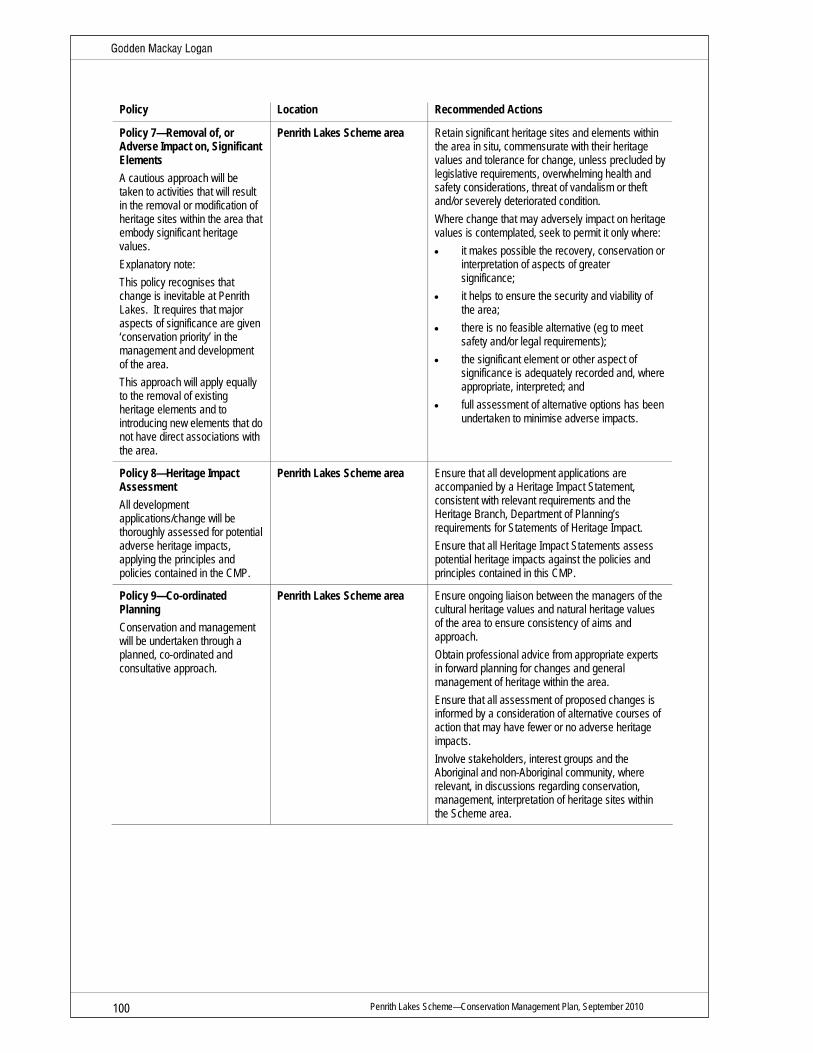
Penrith Lakes Scheme—Conservation Management Plan, September 2010 100
Policy Location Recommended Actions
Policy 7—Removal of, or Adverse Impact on, Significant Elements A cautious approach will be taken to activities that will result in the removal or modification of heritage sites within the area that embody significant heritage values. Explanatory note: This policy recognises that change is inevitable at Penrith Lakes. It requires that major aspects of significance are given ‘conservation priority’ in the management and development of the area. This approach will apply equally to the removal of existing heritage elements and to introducing new elements that do not have direct associations with the area.
Penrith Lakes Scheme area Retain significant heritage sites and elements within the area in situ, commensurate with their heritage values and tolerance for change, unless precluded by legislative requirements, overwhelming health and safety considerations, threat of vandalism or theft and/or severely deteriorated condition. Where change that may adversely impact on heritage values is contemplated, seek to permit it only where: • it makes possible the recovery, conservation or
interpretation of aspects of greater significance;
• it helps to ensure the security and viability of the area;
• there is no feasible alternative (eg to meet safety and/or legal requirements);
• the significant element or other aspect of significance is adequately recorded and, where appropriate, interpreted; and
• full assessment of alternative options has been undertaken to minimise adverse impacts.
Policy 8—Heritage Impact Assessment All development applications/change will be thoroughly assessed for potential adverse heritage impacts, applying the principles and policies contained in the CMP.
Penrith Lakes Scheme area Ensure that all development applications are accompanied by a Heritage Impact Statement, consistent with relevant requirements and the Heritage Branch, Department of Planning’s requirements for Statements of Heritage Impact. Ensure that all Heritage Impact Statements assess potential heritage impacts against the policies and principles contained in this CMP.
Policy 9—Co-ordinated Planning Conservation and management will be undertaken through a planned, co-ordinated and consultative approach.
Penrith Lakes Scheme area Ensure ongoing liaison between the managers of the cultural heritage values and natural heritage values of the area to ensure consistency of aims and approach. Obtain professional advice from appropriate experts in forward planning for changes and general management of heritage within the area. Ensure that all assessment of proposed changes is informed by a consideration of alternative courses of action that may have fewer or no adverse heritage impacts. Involve stakeholders, interest groups and the Aboriginal and non-Aboriginal community, where relevant, in discussions regarding conservation, management, interpretation of heritage sites within the Scheme area.

Penrith Lakes Scheme—Conservation Management Plan, September 2010 101
Policy Location Recommended Actions
Policy 10—Co-operation of Lessees and State Government When specified heritage sites within the Penrith Lakes Scheme area are transferred to state government or offered directly to the market for private leasehold, the principles and policies of the CMP will continue to apply. For some heritage sites within the Scheme area individual CMPs will be prepared. Apply those policies in concert with the policies in this CMP.
Heritage sites—Hadley Park, Smith Road and Landers Inn and Stables
Establish conservation leases for heritage sites, where applicable, and incorporate appropriate clauses in lease agreements to ensure that the lessee undertakes to abide by the principles and policies of the CMP. Ensure that lessees manage their tenancies in a manner that is consistent with the CMP by: • undertaking regular inspections of leased
areas; • identifying and rectifying improper actions; • providing a copy of the CMP to all lessees and
owners of the site, or part of the site; and • identifying mutually acceptable mechanisms for
the conservation of the site through consultation with lessees, where possible.
Policy 11—Preferred Principal Use Continuing use of the area for agriculture or community use (visitors and education centres, museums, cafes etc) with water-based recreation areas and residential development that sympathetically incorporates and appropriately interprets the heritage values of the area.
Penrith Lakes Scheme area New residential development within the Penrith Lakes Scheme area will conserve significant historic views and significant heritage sites. Ensure heritage is a key consideration of future masterplanning for the site.

Penrith Lakes Scheme—Conservation Management Plan, September 2010 102
6.4 Research, Listings and Documentation The following policies reflect the importance of the Penrith Lakes Scheme area as a research instrument and of maintaining an ongoing archival record of the place, including changes made.
Policy Location Recommended Actions
Policy 12—Further Research The management of the heritage values within the Penrith Lakes Scheme area will be informed by an ongoing program of research.
Penrith Lakes Scheme area Undertake specific and directed research towards achieving best-practice conservation outcomes at individual heritage sites where change is proposed or necessary for specific elements (eg works to walls at Hadley Park or detailed historic landscape management plan for the garden at Hadley Park). Monitor the effectiveness of the policies contained in the CMP with respect to the management of specific heritage sites. Prepare CMPs or Specific Element Conservation Policies (SECPs) for individual elements of the site where more specific and directed guidance is needed (see also Policy 13/14 below). Facilitate access to records by students and researchers for bona fide research purposes. Work with Penrith City Council Library Local Studies Collection librarians to establish a program for community-based historical research, oral history and family history research projects. Consider developing the program based on research recommendations in Carol Liston’s Draft Report titled ‘Castlereagh History’ and OHM Consultants’ Penrith Lakes Scheme Oral History Study.
Policy 13—Heritage Sites Conservation Management Planning Where circumstances require it, ensure CMPs and other Heritage Management Plans are prepared for individual heritage sites/collections within the Penrith Lakes Scheme area.
Heritage sites Ensure that any management plans are prepared by appropriately qualified people. Submit any CMPs to the Heritage Council of NSW for endorsement. Historic Landscape Management Plans should be prepared for the gardens at Hadley Park, and The Poplars if ownership transfers to PLDC. A Collections Management Plan should be prepared for the Penrith Lakes archaeological collections held by the Nepean District Historical Archaeological Group (NDHAG).
Policy 14—Conservation and Maintenance Records An ongoing record of change at the area will be maintained as part of the management of heritage values. Explanatory note: Documentation is an important part of heritage conservation, not only for recording what has been undertaken but also to guide future management as to the success or otherwise of particular works and programs.
Penrith Lakes Scheme area Record to archival standard any physical change made to any significant part of the area (for example, conservation works, removal or repair of significant fabric etc). Keep all copies of the above documents in secure premises. Conserve, annotate and safely store all original documents and records related to conservation and maintenance works to heritage sites within the Penrith Lakes Scheme area at PLDC offices. Maintain electronic and hard copies of documents. Where records or collections related to the Scheme area are held by other organisations, individuals or groups, PLDC should seek to establish an ongoing relationship with the custodian and create a centralised, easily accessible inventory or database of the items.

Penrith Lakes Scheme—Conservation Management Plan, September 2010 103
Policy Location Recommended Actions
Policy 15—Heritage Register Listings and Nominations Safeguard the heritage values of the sites by pursuing a policy of nominating to, and/or maintaining on, relevant heritage registers/lists. Existing listings will be reviewed and updated on an ongoing basis.
Heritage Sites Liaise with the Heritage Branch, Department of Planning in order to have the eligible heritage sites within the Scheme SHR-listed to reflect the Statement of Significance contained in this CMP and future area uses. Commission a suitably qualified heritage practitioner to prepare SHR nominations for eligible sites using the CMP or individual CMPs.
Policy 16—Site Recording for Archival Purposes The management of the heritage values at the site will involve an active and ongoing program of archival recording.
Heritage sites Record the existing site layout and key components of the site to archival standard prior to carrying out any change there. Lodge copies of any archival records with the Penrith City Council Library, the Mitchell Library and the Heritage Branch, Department of Planning. Observe the archival recording standards established by the Heritage Branch, Department of Planning.

Penrith Lakes Scheme—Conservation Management Plan, September 2010 104
6.5 Qualifications, Experience and Abilities The following policies reflect the specialised nature of heritage conservation and the need to ensure that it is carried out by appropriately qualified and experienced people.
Policy Locations Recommended Actions
Policy 17—Appropriate Qualifications and Training Seek guidance from suitably qualified people when making decisions that may impact on the heritage values associated with heritage places.
Heritage sites Pursue an active and ongoing training program for all relevant new and existing staff (and external contractors where relevant) which reflects the content and intent of the CMP. Delegate responsibility for assessing and managing development applications to appropriately qualified staff. Ensure heritage personnel have relevant experience and qualifications prior to employment or through training after employment commences. Establish conservation-focused continuous improvement programs for all relevant staff. Ensure that all relevant staff and tenants attend heritage awareness training on induction.
Policy 18—Specialist Conservation Advice Only appropriately qualified people will provide advice on, or undertake, conservation works and future development at heritage sites within the area.
Heritage sites Assess the qualifications, experience and expertise of all contractors providing input into conservation and heritage management matters prior to their engagement. Only engage contractors that have proven and relevant experience or ability. Seek professional archaeological advice in relation to any work which will involve ground disturbance in areas identified by the AMP as having significant archaeological potential. Seek the advice of an arborist in relation to any work which may impact on identified significant remnant plantings.
Policy 19—Qualified Tradespeople All works to elements of the heritage sites embodying significant heritage values will be carried out by suitably qualified tradespeople with practical experience or proven ability with respect to heritage conservation.
Heritage sites Assess the qualifications, experience and expertise of all tradespeople undertaking works prior to their engagement. Only engage contractors that have proven and relevant experience or ability.

Penrith Lakes Scheme—Conservation Management Plan, September 2010 105
6.6 Community Engagement and Interpretation The Interpretation Strategy that has been prepared by Godden Mackay Logan for the Penrith Lakes Scheme area is the overarching document for heritage interpretation of the site. The Interpretation Strategy should be referred to for specific guidance regarding heritage interpretation for the Scheme area and individual heritage sites and should be used when you are planning to engage with the community. The strategy provides guidance for community engagement as part of heritage interpretation.
The following policies reflect the importance of community engagement to the management and conservation and interpretation of the Penrith Lakes Scheme area and individual heritage sites. They are compatible with the Interpretation Strategy.
Policy Locations Recommended Actions
Policy 20—Community Information The management of the Penrith Lakes Scheme area will include an ongoing program of public engagement, designed to maximise public interest and involvement in the heritage values of the site.
Penrith Lakes Scheme area Keep members of the public informed of the heritage values of the site and issues and developments there through links on the PLDC website, the Penrith City Council website, regular newsletters, press releases, public meetings etc, as appropriate.
Policy 21—Interpretation Requirements The management of the heritage values within the Penrith Lakes Scheme area will include an active and ongoing program of interpretation that is informed by the Interpretation Strategy and the place’s heritage values, and which employs a wide range of media.
Penrith Lakes Scheme area The Interpretation Strategy should inform the landuse detail and design development of the Masterplan for the Penrith Lakes Scheme area. Assess all development applications relevant to the area against the overarching requirement to ‘tell the story’ of Castlereagh’s history and heritage. Ensure that change within the Penrith Lakes Scheme area enhances the site’s ability to ‘tell the story’ of Castlereagh. Obtain the advice of appropriately qualified professionals in devising and implementing the interpretation program.
Policy 22—Interpretation Strategy The Interpretation Strategy identifies the themes and messages to be interpreted that reflect the heritage values of the site. It includes discussion of methods that can be used to interpret the significant values and associations of the site. These might include conserving original features and fabric, interpreting/representing missing or damaged elements based on documentary and/or archaeological evidence, and introducing interpretive devices such as signage and public art.
Penrith Lakes Scheme area Undertake consultation with the Heritage Branch, Department of Planning to ensure the Interpretation Strategy is consistent with the desired aims and approach. Aim interpretation measures at a wide audience, including new residents, scholars, special interest groups and the public. Ensure that interpretation is accessible to people from a wide range of backgrounds and abilities. Undertake consultation with the relevant members of the heritage profession, Aboriginal community, interest groups such as Nepean District Local Historical Society and Nepean District Historical Archaeology Group and the National Trust (Hawkesbury Branch) to refine and develop select options for heritage interpretation of the site. Ensure that interpretation is inclusive and integrates Aboriginal history and heritage, and communicates significant natural and cultural values.

Penrith Lakes Scheme—Conservation Management Plan, September 2010 106
Policy Locations Recommended Actions
Policy 23—Interpretation Through Conservation Works Preservation, restoration, reconstruction and reinstatement are preferred methods of interpreting the area’s heritage values.
Penrith Lakes Scheme area Obtain the advice of appropriately qualified professionals to identify elements of the area that can (and cannot) be preserved, restored, reconstructed and reinstated. Where adaptation is part of the conservation work, incorporate measures to show the location, character and/or role of removed or altered components, where appropriate. Where possible, reveal previously hidden or obscured elements that embody heritage values as part of any reconstruction and adaptation works. Where possible, define new elements and fabric (including elements of landscape setting) as part of any reconstruction, adaptation and reinstatement works. Initiate a public program that focuses on conservation in practice at Penrith Lakes to engage the public. Where practical, provide regular opportunities for the public to visit restoration projects in progress and update the PLDC website with photographs and text documenting on-site work in a visually appealing and informative way.
Policy 24—Interpretation as Part of New Development Where appropriate, new development within the area (and, in some circumstances, on sites in its vicinity) will incorporate interpretation measures designed to ‘tell the story’ of the Castlereagh Valley landscape and its people.
Penrith Lakes Scheme area Include measures to interpret and reflect the layered ‘story of Castlereagh’ and its cultural landscape in new developments through design, treatments, fabric, plantings, materials etc. Assess all development applications relevant to the site against the overarching requirement to ‘tell the story’ of Castlereagh’s history and heritage. Provide for opportunities during periods of change at the site to ‘tell the story’ of Castlereagh. Ensure heritage sites that have been demolished are incorporated into future interpretation. The ideal location for an interpretation centre would be within Castlereagh School and schoolmasters residence.

Penrith Lakes Scheme—Conservation Management Plan, September 2010 107
Policy Locations Recommended Actions
Policy 25—Maintaining Legibility of Site Configuration The management of the heritage values of the Penrith Lakes Scheme area will be guided by the overarching principle that future development will enhance the ability of the area to demonstrate early and original landuses. Significant cultural landscapes must be conserved where extant and reinstated/interpreted as part of redevelopment where possible. Explanatory note: This policy provides a framework for interpreting key aspects of the function and use and subsequent evolution as part of its conservation and ongoing development.
Penrith Lakes Scheme area Maintain/interpret the significant historic and visual and physical links between the heritage sites within and surrounding the Penrith Lakes Scheme area (eg Macquarie township, Christchurch). Maintain and reinstate, where possible, the sense of open space and of the former rural uses within the Scheme area. Where possible, plan for small farm allotments as part of future development to ensure the historical significance of the area is retained. Conserve the significant individual components that ‘tell the story’ of the area’s former uses and layout. Retain the use of names associated with historic elements such as land grants, roads, laneways, places and individuals when naming new features as part of future development (eg McCarthy’s Lane, Jacksons Lane, Minnaville). Investigate, record and interpret (where appropriate) the archaeological evidence of the original/earlier development.
Policy 26—Public Access The future site manager will ensure that public access to the area is maximised, provided this is consistent with the site’s heritage values and subject to other requirements (eg security and safety).
Penrith Lakes Scheme area Assess the robustness of the archaeological relics at the site and implement display/interpretation options that reflect their ability to tolerate exposure to the elements, pedestrian activity etc. Provide appropriate and well-signed public entry/exits. Provide safe, adequate and visually unobtrusive parking for visitors to the area. Provide directional signage in a practical but visually discreet manner, ensuring no adverse impacts on heritage values (such as aesthetic values). Meet relevant standards for disabled access. Where this may impact on heritage values, locate the necessary changes in areas of high tolerance for change and, where this is not possible, ensure liaison between building heritage specialists and the certifier/consent authority to achieve a mutually satisfactory response. Continue to encourage community groups and other interested members of the public to access and tour heritage sites within the area subject to standard PLDC security and safety protocols.

Penrith Lakes Scheme—Conservation Management Plan, September 2010 108
6.7 The Archaeological Resource The following policies reflect the importance of the known and potential archaeological resource to the heritage values of the site and the fact that they are the principal physical remains of the earliest uses of the site. Refer to the Archaeological Management Plan, currently in preparation for further detail.
Policy Location Recommended Actions for Owner/Manager
Policy 27—Unexpected Aboriginal ‘Objects’ Any Aboriginal archaeological sites/objects exposed at the site will be managed in accordance with the National Parks and Wildlife Act 1974 (NSW) (the NPW Act). Explanatory note: The Aboriginal archaeological resource is beyond the scope of this CMP. The recommended actions under this policy are general in nature and reference should be made to the Penrith Lakes Aboriginal Cultural Heritage Conservation Management Plan prepared by Jillian Comber.
Penrith Lakes Scheme area Should any Aboriginal sites/objects be identified during future site works, all activities should cease within the find vicinity and the advice of the Department of Environment and Climate Change (DECC) should be sought. Consultation with the local Aboriginal community will be necessary.
Policy 28—Management of Historical Archaeological Remains The management of the archaeological relics (known and potential) will be given high priority in the management, re-use and planning for the heritage sites and land within defined curtilages. In-situ retention of significant relics within the heritage sites will be the preferred method of management in all cases. Minimal development should occur within the heritage sites other than interpretive media and associated pathways to assist people in understanding the history of the heritage sites. Works such as interpretive media must be planned within the heritage sites in ways so as not to disturb archaeological relics.
Heritage sites Adopt the Penrith Lakes AMP as the basis for the management of known and potential historical archaeological relics identified within the area. Locate new development, including landscaping and interpretation facilities, in areas where there is low potential for archaeological relics to be adversely impacted. Minimise or avoid ground disturbance in areas of archaeological potential. Ensure that any ground disturbance within the heritage sites is preceded by an archaeological investigation. The archaeological investigation needs to be carried out in accordance with the Heritage Act 1977 (NSW).

Penrith Lakes Scheme—Conservation Management Plan, September 2010 109
Policy Location Recommended Actions for Owner/Manager
Policy 29—Management of Historical Archaeological Collections There is a significant collection of artefacts associated with Penrith Lakes held by the Nepean District Archaeological Group (NDHAG).
Penrith Lakes Ensure that collections are managed in a safe, secure and environmentally stable environment. Ensure that archaeological collections are appropriately provenanced. Collections have research potential. Provide public access to collections and encourage research to better understand significance. Investigate the potential for the use of unstratified archaeological materials for interpretive purposes in the public domain. Maximise opportunities for interpreting remains that have already been excavated. Liaise with organisations and individuals that are known to hold collections. Work with NDHAG to find appropriate premises for storage and display/interpretation of artefacts. Prepare a Memorandum of Understanding between PLDC and NDHAG to ensure ongoing conservation and management of the archaeological collections excavated from the Penrith Lakes Scheme area.
Policy 30—Obligations of Contractors The site manager will ensure that all contractors and external personnel are aware of their obligations under the Heritage Act and the NPW Act with respect to the archaeological resource.
Heritage sites Include suitable clauses in all contractor and subcontractor contracts to ensure that on-site personnel are aware of their obligations with respect to the archaeological resource. Specifically, relevant on-site personnel should be made aware of the procedure to be followed for notification and stopping work should items of heritage significance be found during site works.

Penrith Lakes Scheme—Conservation Management Plan, September 2010 110
6.8 Landscape and Setting Conservation of the natural and cultural landscape setting is integral to the care and management of heritage sites.
Natural elements of landscapes inevitably change as plants go through their life cycle. The following policies reflect the need to manage this process.
The policies also reflect the need to retain, reinstate (where possible) and conserve the rural landscape character including its historic views, boundaries and plantings within the Penrith Lakes Scheme area.
The wider setting for heritage sites within the Penrith Lakes Scheme area has been extensively quarried for gravel and sand. The former rural character of the landform has been dramatically altered and only fragments remain. Planned remediation and future development of the Scheme area provides an opportunity to reinstate areas of rural landscape, particularly to maintain historic views and enhance the setting within the immediate vicinity of heritage sites.
Setting is regarded as an essential part of heritage significance, recognised by Australia ICOMOS in the Burra Charter. Proposed future changes in landuse, or development of adjoining and nearby lands need to be carefully examined for any potential impacts on the quality of setting.
The broad-scale change to the landform and vegetation across the Penrith Lakes site provides opportunities for natural heritage, including the reinstatement of indigenous plant communities such as Cumberland Plain woodland—identified as an Endangered Ecological Community under Schedule 1 of the Threatened Species Conservation Act 1995 (NSW).
The ‘Castlereagh Biodiversity and Natural Heritage Conservation Masterplan: Delivering key aspects of the Urban Ecology Vision’ prepared by Total Catchment Management Services Pty Ltd, provides detailed guidance for the re-establishment of many vegetation communities that formerly existed at Penrith Lakes.
Policy Location Recommended Actions for Owner/Manager
Policy 31—Cultural and Natural Heritage The Penrith Lakes Scheme area will be managed according to the principle that cultural and natural heritage values are mutually supportive. Where the management needs of the two kinds of values are in conflict, the needs of the cultural heritage values will prevail within the curtilages of heritage sites.
Penrith Lakes Scheme area Ensure the future masterplan landscape options are consistent with this CMP. Finalise the Castlereagh Biodiversity and Natural Heritage Conservation Masterplan to deliver natural heritage outcomes for the site. Ensure significant natural and cultural heritage values are protected and conserved during remediation and redevelopment. The masterplanning process for the site should integrate natural and cultural heritage values by involving relevant professionals during design development.

Penrith Lakes Scheme—Conservation Management Plan, September 2010 111
Policy Location Recommended Actions for Owner/Manager
Policy 32—Landscape and Setting Management The landscape and setting of the heritage sites will be managed and developed as a central and fundamental part of the area’s overall significance. Explanatory Note: In this context, ‘landscape’ refers to landscaping such as trees, plantings, garden beds, grant boundaries, fencelines, kerbs, paths etc, as well as the wider cultural landscape.
Penrith Lakes Scheme area Consult the Penrith Lakes Development Scheme Landscape Heritage Strategy for guidance regarding management of landscape and setting. Consult the CMPs for 43 Smith Road, Landers Inn, McCarthy’s Cemetery and Hadley Park for conservation management of the cultural landscape and setting. Where appropriate, develop site-specific historic landscape management plans for heritage sites. Ensure that significant trees and shrubs within the area are managed by personnel experienced in working in heritage landscapes and heritage trees/plantings. Enforce the application of relevant Australian standards (eg AS 4373 Formative Pruning) and current best practice in arboriculture as recommended by relevant industry representative groups. Base decisions on whether to retain or remove particular trees on safety considerations, their relative significance, contribution to the landscape as a whole, and amenity value. Control and/or remove weeds and problem species (such as lantana, privet etc) as part of an ongoing maintenance program and in collaboration with adjoining landholders. Monitor the site for the presence of any feral or native animals that might have an adverse impact on landscape elements (eg rabbits, possum damage to significant trees etc). Work with Hawkesbury Nepean Catchment Trust to manage and control weed infestation along the Nepean River within the area.

Penrith Lakes Scheme—Conservation Management Plan, September 2010 112
Policy Location Recommended Actions for Owner/Manager
Policy 33—Management of the Effects of Change on the Landscaping and Setting Changes to the area’s landscaping will be sympathetic to the heritage values of Castlereagh and heritage sites within the area, particularly (although not solely) in relation to the area’s aesthetic values.
Penrith Lakes Scheme area Design any new plantings/gardens so that they are in keeping with existing significant landscapes and landscape elements, and using design and materials consistent with, or at least not in conflict with, that particular part of the area. Ensure that planting in historic viewlines retains an open rural character and visual connections to and from heritage sites within the area. Ensure that new plantings do not obscure historic views and are restricted to species of a low height that are compatible with the area’s established open character. Ensure that roadside vegetation, if any, is of a species complementary to the heritage values of the area. Ensure visual buffer areas are maintained within the vicinity of heritage sites to protect visual presence, original land grants historic connections, heritage sites and other former land grants located within the Scheme area. Ensure that work sites are left in good condition after construction and other works. Waste material such as excess cement and other rubbish should be removed by contractors, workers etc (Articles 22.1, 22.2, Burra Charter). Construct any new masonry in accordance with relevant industry standards. Ensure that only stonemasons (or other tradespersons) with appropriate experience or ability carry out the work.
Policy 34—Guidelines for Landscaping Repairs The maintenance of significant landscaping at the site will be undertaken as a matter of high priority, according to relative levels of significance, and as part of an ongoing maintenance and improvements program.
Heritage sites Where a significant element is in poor condition, repair/conserve rather than replace. Ensure that repair work is only undertaken by people with appropriate skills and qualifications. Assess priority for conservation on the basis of relative degree of significance. Consider: • the likelihood of further deterioration if not
repaired. Cost-effectiveness: • The importance of the views to, from and
within the site (new plantings should be selected and located in such a way that they enhance views and curtilages, not block or detract from them).
• The potential impact of the choice of species for new plantings on the relative significance of the area, appropriateness for the period, suitability for the location, ease of maintenance and use (eg screening, visitor control, floral display). The placement and selection of larger specimen trees should be carefully planned to avoid root damage, blocking of views, inappropriate mature dimensions, or incompatibility with the established character of the landscape.

Penrith Lakes Scheme—Conservation Management Plan, September 2010 113
Policy Location Recommended Actions for Owner/Manager
Policy 35—Storage and Disposal of Rubbish, Garden Waste and Building Materials The storage and disposal of waste products at heritage sites will be carried out in a manner that is consistent with the site’s heritage values.
Heritage sites Locate receptacles for rubbish in such a way that they do not detract from the heritage values of the site, particularly its aesthetic values, and the ability of the heritage sites to ‘tell their story’. Monitor the work of contractors on heritage sites and require them to clean up and remove all surplus materials (such as cement, adhesives, drop sheets, packaging materials) when they have completed their work. Ensure that compost heaps are located away from visually prominent areas or otherwise appropriately contained. If service or work areas are established, ensure they are sensitively sited and do not spoil the aesthetic values or experience of the site.
Policy 36—Protection of Setting and Management and Development of Adjoining Lands The appropriate authorities will monitor and regulate proposals for the development of the area in the vicinity of heritage sites and associated historic views to ensure that there is no adverse impact on the wider setting of the place or heritage significance generally.
Penrith Lakes Scheme area Assess all development applications relating to land in the vicinity of heritage sites against heritage values, with particular emphasis on the visual setting and sensitivity of the site. Monitor proposed developments or infrastructure projects on adjoining or nearby land to ensure that any new development is sympathetic to the conservation of heritage values. Retain an appropriate curtilage/setting around conservation zones within the Scheme area.
Policy 37—Maintenance Guidelines for Landscape A proactive and ongoing program of cyclical, planned maintenance will be undertaken at heritage sites consistent with heritage values.
Heritage sites Carry out routine maintenance actions in accordance with the CMP. Develop procedures that ensure maintenance works that may impact on heritage values are first assessed and approved by qualified people. Keep records for all major repairs and maintenance to landscape and built elements in order to ensure an ongoing record of change at the site.
Policy 38—Conservation of Significant Landscape Elements Significant landscape elements will be conserved in accordance with their level of significance/contribution to the significance to the area as a whole.
Heritage sites The cultural plantings at heritage sites should be conserved and maintained in accordance with their ranked level of significance. Retain sections of Old Castlereagh Road in places where heritage sites have a direct historic association to it. (eg Landers Inn). Where possible, retain, reconstruct or interpret former historic laneways in future development within the Scheme area. Where possible, reinstate former historic entries to heritage sites as part of future urban planning.
Policy 39—Landscape Maintenance Schedule The significant landscape components of the heritage sites will be managed/maintained in accordance with an adopted Maintenance Schedule.
Heritage sites Arrange for the preparation of a Maintenance Schedule as part of the ongoing use and management of the heritage sites.

Penrith Lakes Scheme—Conservation Management Plan, September 2010 114
Policy Location Recommended Actions for Owner/Manager
Policy 40—Problem Trees and Arboricultural Maintenance Regular arboricultural inspection should be undertaken and a tree maintenance program developed for heritage trees.
Heritage sites Regularly inspect plantings for damage to significant elements of the site (eg root damage to relics). Monitor significant vegetation for disease, damage etc.
Policy 41—Conservation of Significant Historic Views The form and location of future development/change within the Scheme area will be determined by (among other considerations) identified significant views. Development should not impede historic view lines that extend to and from identified heritage sites.
Penrith Lakes Scheme area Where possible, locate new development outside of significant historic views. Locate new development /change on land that is of low heritage significance and with high tolerance of change. Ensure the bulk, scale and materials used in any new development do not obscure or impede historic views to and from heritage sites.

Penrith Lakes Scheme—Conservation Management Plan, September 2010 115
6.9 Physical Intervention, Including Maintenance The following policies augment the overarching policies above. They relate to works that will impact on the physical elements/fabric of the site.
Policy Location Recommended Action
Policy 42—Standard Exemptions for Works Requiring Heritage Council of NSW Approvals (following the removal or lapse of Part 3A of the EP&A Act to the site) The standard exemptions for works requiring Heritage Council of NSW approval will apply to the area of the site covered by the SHR listing. Explanatory Note: Generally, the consent of the Heritage Council of NSW will be required for proposed works at the site (a Section 60 application would need to be made in some instances). However, minor works may be covered by certain gazetted Standard Exemptions for Works Requiring Heritage Council Approval. (The exemptions are included as Appendix B.)
Heritage sites with SHR listing Assess all proposed actions that may impact on the site against the Heritage Branch’s Standard Exemptions for Works Requiring Heritage Council Approval and the identified exempt works in the Archaeological Management Plan for Penrith Lakes. Delegate an appropriately qualified person or people to make the determination as to whether the proposed works fall within the exemptions. When in doubt, consult with the Heritage Branch, Department of Planning with respect to the proposed works and their relationship with the gazetted Standard and Specific Exemptions to Section 60 approvals.
Policy 43—Ground Remediation If ground remediation is required at heritage sites, the remediation will be co-ordinated with reference to an endorsed AMP.
Penrith Lakes Scheme area Assess the proposed remediation methodology against the AMP to ensure a sound methodological approach that minimises heritage impacts on significance. Obtain specialist heritage conservation advice as part of the assessment process and to provide input in relation to heritage conservation generally.
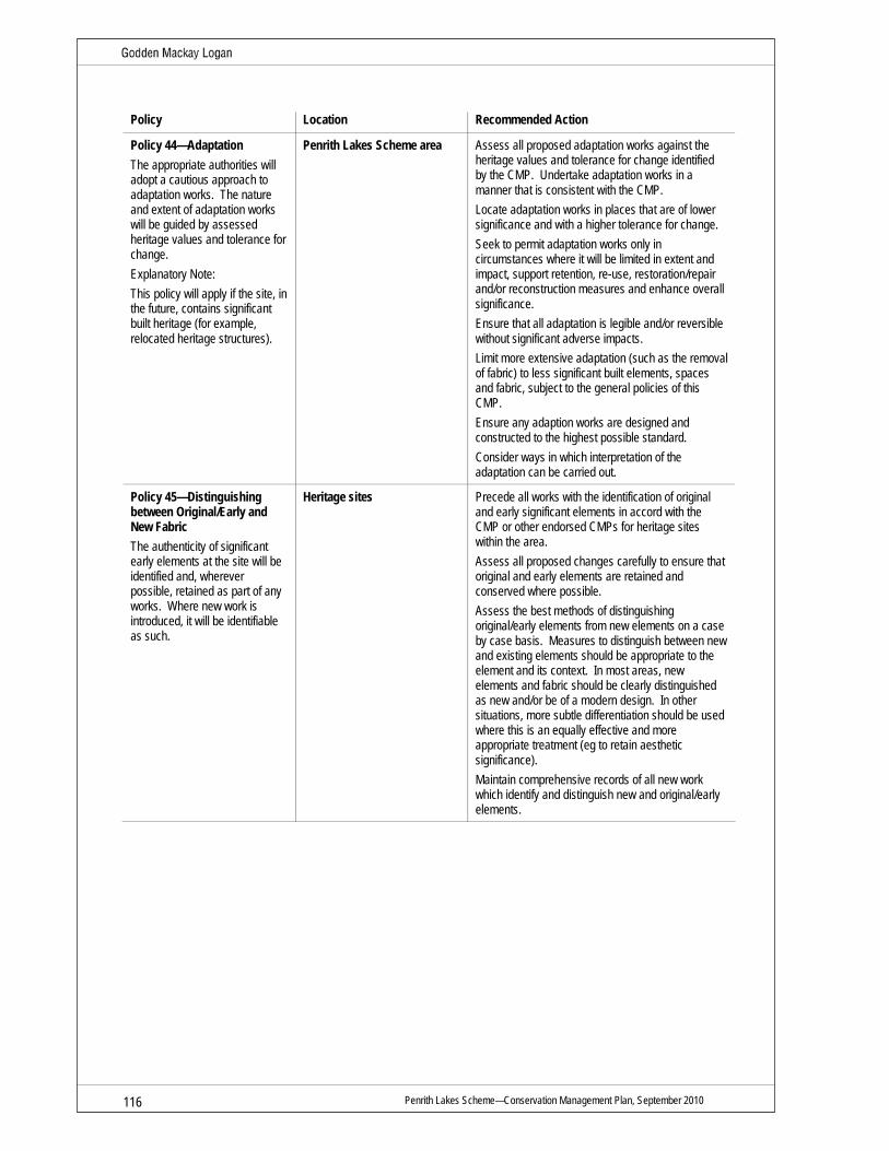
Penrith Lakes Scheme—Conservation Management Plan, September 2010 116
Policy Location Recommended Action
Policy 44—Adaptation The appropriate authorities will adopt a cautious approach to adaptation works. The nature and extent of adaptation works will be guided by assessed heritage values and tolerance for change. Explanatory Note: This policy will apply if the site, in the future, contains significant built heritage (for example, relocated heritage structures).
Penrith Lakes Scheme area Assess all proposed adaptation works against the heritage values and tolerance for change identified by the CMP. Undertake adaptation works in a manner that is consistent with the CMP. Locate adaptation works in places that are of lower significance and with a higher tolerance for change. Seek to permit adaptation works only in circumstances where it will be limited in extent and impact, support retention, re-use, restoration/repair and/or reconstruction measures and enhance overall significance. Ensure that all adaptation is legible and/or reversible without significant adverse impacts. Limit more extensive adaptation (such as the removal of fabric) to less significant built elements, spaces and fabric, subject to the general policies of this CMP. Ensure any adaption works are designed and constructed to the highest possible standard. Consider ways in which interpretation of the adaptation can be carried out.
Policy 45—Distinguishing between Original/Early and New Fabric The authenticity of significant early elements at the site will be identified and, wherever possible, retained as part of any works. Where new work is introduced, it will be identifiable as such.
Heritage sites Precede all works with the identification of original and early significant elements in accord with the CMP or other endorsed CMPs for heritage sites within the area. Assess all proposed changes carefully to ensure that original and early elements are retained and conserved where possible. Assess the best methods of distinguishing original/early elements from new elements on a case by case basis. Measures to distinguish between new and existing elements should be appropriate to the element and its context. In most areas, new elements and fabric should be clearly distinguished as new and/or be of a modern design. In other situations, more subtle differentiation should be used where this is an equally effective and more appropriate treatment (eg to retain aesthetic significance). Maintain comprehensive records of all new work which identify and distinguish new and original/early elements.

Penrith Lakes Scheme—Conservation Management Plan, September 2010 117
Policy Location Recommended Action
Policy 46—Evaluation of Alternatives Changes to significant remains/elements of heritage sites or historic views will be aimed at conserving and/or enhancing the heritage values of the area. Where unavoidable change may impact adversely on heritage values, all alternative courses of action will be considered and the course of action with the lowest potential for adverse impacts will be preferred. Explanatory Note: This policy reflects the need for co-ordinated decision-making to ensure the appropriate conservation of the area’s significant heritage values. It also takes into account the standard requirement of statutory authorities that alternatives be considered where works are proposed which may adversely impact on heritage values.
Penrith Lakes Scheme area Adopt a cautious approach to change. Review all proposed change with reference to the CMP, assessing all proposed change against the significance of affected elements and their tolerance for change. Locate proposed changes, where possible, in areas identified as having the lowest significance and highest tolerance for change. Obtain professional advice, as appropriate, with respect to the assessment of proposed change and the development of possible alternative courses of action. Ensure, where possible, that changes are reversible.
Policy 47—In-Situ Retention The retention of significant fabric in situ will be the preferred management approach.
Heritage sites Retain significant fabric in situ commensurate with its heritage values and tolerance for change, unless precluded by legislative requirements, overwhelming health and safety considerations, threat of vandalism or theft, and/or severely deteriorated condition.
Policy 48—Services and Utilities Services and utilities should be introduced and maintained in a manner which minimises impacts on the heritage values of the area. Note: within heritage sites, services and utilities should be kept to a minimum.
Heritage sites Seek to introduce services and utilities such as water supply, drainage, power and phone-in areas that embody the fewest heritage values.
Policy 49—Financial and Human Resources A regular specific budgetary allocation should be made for conservation purposes (including the maintenance of heritage elements and the cultural landscape, conservation works and specialist advice). This will be in addition to any recurrent budget for routine maintenance.
Penrith Lakes Scheme area Prepare authoritative costings for heritage cyclical maintenance and other conservation works and ensure adequate funds are allocated. If there are budget shortfalls ensure that funding is allocated according to priority.

Penrith Lakes Scheme—Conservation Management Plan, September 2010 118
Policy Location Recommended Action
Policy 50—Fire and Flood Fire and flood can cause devastating and irreversible damage to heritage sites.
Heritage sites Engage appropriate specialists to prepare fire and flood management plans for the heritage sites within the Scheme area to ensure that heritage is adequately protected.
6.10 Heritage Conservation and New Development
6.10.1 Designing for New Uses and Development
The following policies guide the future development of the Penrith Lakes Scheme area in a manner that is consistent with its heritage values.
Policies Location Recommended Actions
Policy 51—Development in the Vicinity of Heritage Sites
Penrith Lakes Scheme area Where possible, maintain a generous curtilage of undeveloped open space around surviving heritage sites/items (preferably as parkland) in order to retain significant traditional views and rural landscape character. The nature of any development in the vicinity of Hadley Park, Nepean Park and Landers Inn should be rural in character in terms of its spacing, scale and siting. Development in these areas should also demonstrate a high level of design and ensure that the rural setting as well as key views as noted in the analysis in section 3.0 are not compromised. Particular elements needing attention include the heights, style, massing, materials, scale and orientation of structures. Any new development in the vicinity of retained heritage sites/items should require a Statement of Heritage Impact.
Policy 52—Uses of Heritage Sites
Heritage sites Ensure proposed uses of heritage sites do not impact on heritage values or significance as identified in this CMP or individual CMPs prepared for heritage sites within the area. Assess proposed uses for their potential to impact on significance and commission suitably qualified heritage professionals to prepare Statements of Heritage Impact as required. Encourage uses that enhance significance, are sustainable and ensure the ongoing life and vitality of heritage sites.

Penrith Lakes Scheme—Conservation Management Plan, September 2010 119
Policies Location Recommended Actions
Policy 53—New Uses The area will be used for uses other than that outlined in Policy 11 only where the proposed use is compatible with the conservation of the area’s heritage values.
Penrith Lakes Scheme area Assess all proposed uses for the area against the heritage values identified in the CMP and their identified tolerance for change.
Policy 54—New Structures New development within the area should respect heritage values.
Penrith Lakes Scheme area Adopt a cautious approach to new development. Assess all proposed development against the Statement of Significance in the CMP and according to identified tolerance for change. In general, locate new development in areas of lower heritage significance and higher tolerance for change. Ensure that new buildings do not dominate the existing, significant character and historic layering of the heritage sites and the evidence of significant functional relationships, associations and non-tangible values there. Where possible, locate new development outside of identified conservation zones. Ensure new buildings are appropriate in terms of siting and setbacks, including the retention of appropriate visual and spatial relationships at the site. Ensure compatibility with other heritage features within the area in terms of scale, form and character of existing elements. Avoid the use of inappropriate period styles, or heritage ‘mimicking’ in new structures. Incorporate enhanced opportunities for interpretation in new development. Retain significant physical, functional and visual relationships between groups or complexes of heritage landscapes and elements.

Penrith Lakes Scheme—Conservation Management Plan, September 2010 120

Penrith Lakes Scheme—Conservation Management Plan, September 2010 121
7.0 Individual Site Inventory Forms
7.1 Introduction The following inventory forms have been prepared for individual heritage sites, collections and historic features within the Penrith Lakes Scheme. They provide an overview of each site or item, its location, condition, historic development, significance and specific policy recommendations.
The information contained in the inventory forms is drawn from site inspections and historic research carried out by Godden Mackay Logan, as well as previous heritage assessments. This information is intended to be used to guide decision making about future development as well as the ongoing maintenance of each site or item within the management framework of the overall Penrith Lakes Scheme.
Conservation Management Plans are being prepared for 43 Smith Road, McCarthy’s Cemetery, Hadley Park and Landers Inn. A CMP has been prepared for McCathy’s Cemetery. For more detailed information regarding the conservation and management of those sites the CMPs should be consulted.

Penrith Lakes Scheme—Conservation Management Plan, September 2010 122

Penrith Lakes, Conservation Management Plan—Site Inventory
Prepared by Godden Mackay Logan, July 2010 123
Place/Element: Nepean Park
Location within the Scheme Area. Site plan not to scale.
Location
• Lies between the Nepean River and Old Castlereagh Rd (Portion 48).
Description, Setting
• Two-storey Georgian farmhouse with cellar consisting of rendered sandstock brick and associated outbuildings and garden (see site plan in Britton and Morris 1999). A former orchard and a new orchard are included within the immediate setting of the homestead, and some new structures (such as a garage). The homestead features its original six panelled door and stone flaggings along the front verandah. Although there have been some alterations and additions to Nepean Park it remains substantially intact.
• Address to Old Castlereagh Road. Wider surroundings extensively quarried. Hadley Park is located to the north.
• The entrance is marked by two large Kurrajong trees. Some remaining Peppercorn Trees (planted by John Single). Other plantings include Jacarandas, Silky Oak, She-Oak, Ironbarks, Cypresses, Willows, and a new orchard. Views of Christ Church.
Summary Statement of Significance • Nepean Park comprises an intact two storey Georgian homestead, associated outbuildings and gardens. • Architecturally significant colonial building built in 1822 using convict labour, sited on a land grant dating to 1803. • Prominent local landmark with strong historical connections to neighbouring Hadley Park and Christ Church.
Uses Historic Use: Farm and homestead. Present Use: Privately owned residence. Potential Use: Continue use as private residence.

Penrith Lakes, Conservation Management Plan—Site Inventory
Prepared by Godden Mackay Logan, July 2010 124
Place/Element: Nepean Park
Historical Development: • Located on the original 140 acre property initially granted to William Tonks in 1803. The property was sold to John Palmer in 1810,
then purchased by Samuel Foster in 1815. In 1819 title was transferred to Foster’s step-son John Single. • By 1822 Single has acquired a total of 240 acres—most of which was cleared for farming. • The Homestead was constructed in 1822 using convict labour. John Single and wife proceeded to cultivate gardens, orchards and
a vineyard. A school was established on the property in the 1830s. • Single’s Ford formerly located at the rear of the property used for driving stock between Nepean Park and inland properties over
the Blue Mountains (no visible evidence remains today). • The property remained in Single family until 1911. The Dixon family purchased it in 1934.
Significance Criteria Historic Demonstrates early settlement of the Castlereagh area.
Retains evidence of original 1803 grant in fencelines, and field cultivation patterns.
Association Associated with early settlers William Tonks and the Single family. Demonstrates a long term association with two families (Single and Dixon). Joseph Daniel owner of Minnaville and son of John Single inherited Nepean Park in 1868 but subsequently gave it to his daughter Isabella when she married. Hadley Park.
Aesthetic Substantial Colonial homestead. Landmark value.
Social An early Colonial property, valued by the community as part of the history of Penrith.
Scientific Demonstrates early construction materials and techniques. High archaeological potential.
Rarity Substantially intact. One of two of the earliest surviving homesteads in the district, state and nation.
Representative Georgian farmhouse complex.
Tolerance for Change
Little
Level of Significance
Local State National
Historic Association Aesthetic Social Scientific Rarity Representative
Condition and Constraints
• Current condition unknown as access was not granted to the site; however, the last report from 1995 was that the homestead remained substantially intact and in good condition, PLDC own the eastern portion of the site, the Dixon family owns the remaining land (according to Britton & Morris).
• Located within a PLDC conservation zone.

Penrith Lakes, Conservation Management Plan—Site Inventory
Prepared by Godden Mackay Logan, July 2010 125
Place/Element: Nepean Park
Fabric Conservation Guidelines
Homestead Prepare a building condition report outlining structural issues and urgent maintenance required. This should commence with the identification and elimination of agents of deterioration, such as rising and falling damp and termite activity, through the careful opening up and investigation of fabric. Conservation should be guided by specialist advice regarding the building’s structural condition, fabric and finishes. Original fabric should be retained and stabilised in situ wherever possible. Regular inspections and maintenance should ensure the building is secure and weather tight, including roofs, rain water goods, doors and windows.
Early/ original outbuildings Retain and stabilise where possible.
Setting Where possible, retain and reinstate significant viewlines. Where possible, reinstate traditional fencelines along original grant alignments. Manage as a cultural landscape. Extend the PLDC conservation zone by maintaining open areas of pasture for grazing or cropping or passive recreation surrounding Nepean Park.
Garden Maintain garden and implement weed management system. Retain any noxious or invasive species (self seeding etc) within site curtilage but do not replace when dead. Replace with similar native species.
Policy Recommendations: • A CMP should be prepared for Nepean Park. • Nepean Park should be managed as part of a homestead group that includes Hadley Park. • Original fabric that is missing, damaged or deteriorated should be replaced with fabric that is similar in appearance, material and
method of fixing to existing fabric, and is date marked. • Consider establishing a heritage curtilage that includes Hadley Park and aligns with historic boundary lines for Hadley Park and
Nepean Park. Maintain the significant historic connection to the Nepean River. • Conserve character and fabric of place, including homestead and associated outbuildings and garden. Conservation and
maintenance should involve minimal intervention in fabric. • Retain historic fabric and traditional plantings in situ. Where fabric is removed or altered in accordance with conservation and
maintenance requirements should first be archivally recorded. • Moveable heritage collections associated with the property should be recorded, assessed and conserved. • Extant traditional fencelines should be identified, retained and interpreted. • No new structures should be located amongst the existing farm operation. • New uses should be sought which are compatible with the original function as well as with heritage significance, options may
include a private dwelling with a lease that includes maintenance and conservation of the site. • No additions should be introduced which will compromise, damage or obscure the significance of the buildings or their immediate
setting. Any additions should be designed following detailed advice from a heritage consultant, and should be the subject of a Statement of Heritage Impact.
• Important views to Hadley Park and Christ Church should be retained. Where vegetation or structures obstruct views to Hadley Park these should be pruned relocated or removed.

Penrith Lakes, Conservation Management Plan—Site Inventory
Prepared by Godden Mackay Logan, July 2010 126
View of Nepean Park. (Source: PLDC).
Nepean Park (RES 5) as it was in 1987. (Source: Penrith City Council)
The PLDC conservation area is shown shaded. The historic grant boundaries for Hadley Park and Nepean Park are shown outlined in black.
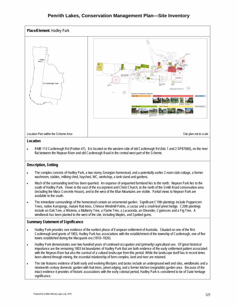
Penrith Lakes, Conservation Management Plan—Site Inventory
Prepared by Godden Mackay Logan, July 2010 127
Place/Element: Hadley Park
Location Plan within the Scheme Area Site plan not to scale
Location
• RMB 113 Castlereagh Rd (Portion 47). It is located on the western side of old Castlereagh Rd (lots 1 and 2 DP87060), on the river flat between the Nepean River and old Castlereagh Road in the central west part of the Scheme.
Description, Setting
• The complex consists of Hadley Park, a two storey Georgian homestead, and a potentially earlier 2 room slab cottage, a former washroom, stables, milking shed, hayshed, WC, workshop, a tank stand and gardens.
• Much of the surrounding land has been quarried. An expanse of unquarried farmland lies to the north. Nepean Park lies to the south of Hadley Park. Views to the east of the escarpment and Christ Church, to the north of the Smith Road conservation area (including the Mass Concrete House), and to the west of the Blue Mountains are visible. Partial views to Nepean Park are available to the south.
• The immediate surroundings of the homestead contain an ornamental garden. Significant C19th plantings include Peppercorn Trees, native Kurrajongs, mature fruit trees, Chinese Windmill Palms, a cactus and a small-leaf privet hedge. C20th plantings include an Oak Tree, a Wisteria, a Mulberry Tree, a Flame Tree, a Jacaranda, an Oleander, Cypresses and a Fig Tree. A windbreak has been planted to the west of the site, including Maples, and Spotted gums.
Summary Statement of Significance
• Hadley Park provides rare evidence of the earliest phase of European settlement of Australia. Situated on one of the first Castlereagh land grants of 1803, Hadley Park has associations with the establishment of the township of Castlereagh, one of five towns established during the Macquarie era (1810–1820).
• Hadley Park demonstrates over two hundred years of continued occupation and (primarily) agricultural use. Of great historical importance are the remaining 1803 lot boundaries of Hadley Park that are both evidence of the early settlement pattern associated with the Nepean River but also the survival of a cultural landscape from this period. While the landscape itself has in recent times been altered through mining, the essential relationship of farm complex, land and river are retained.
• The site features evidence of both early and evolving lifestyles and tastes include an underground well and silos, windbreaks and a nineteenth century domestic garden with fruit trees, privet edging, and a former kitchen (vegetable) garden area. Because of the intact evidence it provides of historic associations with the early colonial period, Hadley Park is considered to be of State heritage significance.

Penrith Lakes, Conservation Management Plan— Site Inventory
Prepared by Godden Mackay Logan, July 2010 128
Place/Element: Hadley Park
Uses Historic Use: Farm and homestead Present Use: Private residence Potential Uses: Continue use as private residence, farm and homestead. Consider establishing a long term private lease with clauses requiring ongoing conservation, maintenance and public open days annually for private sale. Consider use as a house museum, or cultural centre with artists or writers/musicians in residence.
Historical Development • Located on part of the 80 acres originally granted to Martin Mince in 1803(or Mentz). Mince farmed 50 acres and leased his
remaining 30 acres (on the northern side of the grant) to Charles Hadley. • In 1811, Martin Mince sold all 80 acres of his grant to Ann Landers for £150 who then immediately transferred the property to
Charles Hadley for the same sum. He then named it ‘Hadley Park’. • Hadley is believed to have built the single storey slab outbuilding c.1806 and then, between 1811 and 1828 built the main
farmhouse, the former stables, a milking shed, a barn (which burnt down in 1873) and other farmhouse outbuildings (possibly including a wood storage shed). By 1822 Hadley had expanded land holdings to 400 acres, including an orchard and a slaughter yard (supplying meat to Govt stores 1815–1824). Also recorded in 1826 as an innkeeper, of the ‘First and Last’. No separate building located on the Hadley Park property.
• Charles Hadley died 1828 and left Hadley Park to son Charles Hadley Jnr. He remained at Hadley Park until his death in 1891, was responsible for several modifications. His eldest daughter Louise Matilda, and husband William Alvin Childs inherited the property. In 1905 Hadley Park was in ownership of their eldest son William Charles Hadley Childs. Following his death property was divided in 2 amongst his son and daughters, however, continued to be farmed as one.
• Dairy farming continued into the 1950s. A number of modifications were made to the property 1900–1950 • Most recently occupied by Jacqueline Flower, a sixth generation descendant of Charles Hadley.
Significance Criteria Historic Demonstrates early settlement of the Castlereagh area.
Contains two of Australia’s earliest buildings including a weatherboard cottage thought to predate 1806.
Association Original grantee, Martin Mince, and early Castlereagh families the Hadley’s and the Child’s. Association with the Hadley family is ongoing. Nepean Park.
Aesthetic Distinctive jerkin headed farmhouses and garden. Landmark value.
Social An early Colonial property, valued by the community as part of the history of Penrith.
Scientific Demonstrates early construction materials and techniques High archaeological potential.
Rarity Highly intact. One of two of the earliest surviving homesteads in the district, state and nation.
Representative Georgian farmhouse complex.
Level of Significance
Local State National
Historic Association Aesthetic Social Scientific Rarity Representative
Condition and Integrity

Penrith Lakes, Conservation Management Plan—Site Inventory
Prepared by Godden Mackay Logan, July 2010 129
Place/Element: Hadley Park
• High degree of intactness but generally in poor condition as a result of poor maintenance, termite damage and water egress. Located within a conservation zone. Listings include SREP11 and National Trust (NSW).

Penrith Lakes, Conservation Management Plan— Site Inventory
Prepared by Godden Mackay Logan, July 2010 130
Place/Element: Hadley Park
Fabric Conservation Guidelines
Homestead A comprehensive and integrated conservation program is urgently required. This should commence with the identification and elimination of agents of deterioration, such as rising and falling damp and termite activity, through the careful opening up and investigation of fabric. Conservation should be guided by specialist advice regarding the building’s structural condition, fabric and finishes. Original fabric should be retained and stabilised in situ wherever possible. Regular inspections and maintenance should ensure the building is secure and weather tight, including roofs, rain water goods, doors and windows.
Slab Cottage Remove vegetation encroaching on building fabric. Retain and stabilise.
Other Outbuildings (including washhouse, former stables and dairy)
Retain and stabilise where possible. Consider adaptively reusing the studio and bathroom/toilet.
Setting Retain and reinstate significant viewlines. Where possible, reinstate historic alignment of entry drive based on documentary evidence. Retain the historic connection between Hadley Park and the Nepean River. Maintain existing ground levels within the heritage curtilage for Hadley Park as defined in the Hadley Park CMP July 2010. Reinstate traditional fencelines along original 1803 grant alignments where possible. Retain windbreak to the west of the homestead. Manage as a cultural landscape. Consider maintaining open areas of pasture for grazing or cropping.
Garden Maintain garden and implement weed management system. Retain any noxious or invasive species (self seeding etc) within site curtilage but do not replace when dead. Replace with similar native species. Consider re-establishing a kitchen garden.
Policy Recommendations:

Penrith Lakes, Conservation Management Plan—Site Inventory
Prepared by Godden Mackay Logan, July 2010 131
Place/Element: Hadley Park
• Conserve and manage Hadley Park in accordance with the Hadley Park CMP July 2010. • Conserve and maintain the heritage significance of the place, including the homestead and associated outbuildings and their
setting. • Conservation and maintenance should be implemented based on an integrated approach following the thorough identification,
assessment and prioritisation of all issues and risks to the fabric and setting, and carried out by appropriately skilled professionals and specialised tradespeople, in accordance with this CMP.
• The area within the heritage curtilage should be managed in accordance with the Hadley Park CMP. • Any missing, damaged or deteriorated fabric that requires replacement should be replaced with fabric that is similar in appearance,
material and method of fixing to existing fabric, and is date marked. • Retain historic fabric and traditional plantings in situ. Where fabric is removed or altered in accordance with conservation and
maintenance requirements should first be archivally recorded. • Moveable heritage collections associated with the property should be recorded, assessed and conserved. • No new structures should be located amongst the existing building group. • Hadley Park should be included and interpreted as part of a Penrith lakes heritage trail. • New uses should be sought which are compatible with the site’s original function as well as with its heritage significance. • Visitors inside Hadley Park as a house museum would need to be limited in numbers and accompanied by an appropriate guide
whilst inside the house due to the fragility of the fabric. • No additions should be introduced which will compromise, damage or obscure the significance of the buildings or their immediate
setting. Any additions should be designed by a heritage architect or following detailed advice from a heritage consultant, and should be the subject of an HIS.
• Significant views to Nepean Park, Christ Church and the Smith Road Conservation area (including the Mass Concrete house) should be retained.
• The significance of Hadley Park and historic relationship with Castlereagh and Nepean Park should be interpreted. • Where vegetation or structures obstruct views to Nepean Park in the south, these should be pruned, relocated or removed.
View towards homestead from the main drive entry, with outbuildings visible in foreground. (Source: GML 2007)
Hadley Park homestead constructed c1812, northern façade. (Source: GML 2007)

Penrith Lakes, Conservation Management Plan— Site Inventory
Prepared by Godden Mackay Logan, July 2010 132
Escape hatch located in southern gable. (Source: GML 2008).
Hadley Park homestead constructed c1812, and surrounding garden. (Source: GML 2007)
Garden to the east of the house. (Source: GML 2008)
Slab cottage c1806 located to the north of the farmhouse. (Source: GML 2007)

Penrith Lakes, Conservation Management Plan— Site Inventory
Prepared by Godden Mackay Logan, July 2010 133
Place/Element: McCarthy’s Cemetery
Location within the Scheme Area. McCarthy’s Cemetery site plan, not to scale.
Location
• Located at western end of McCarthy’s Lane, bordering its southern edge (Part Portion 82).
Description, Setting • McCarthys Cemetery occupies a small level site enclosed by a timber post and rail fence (replaced in the 1990s), and perimeter
plantings. Following a formal rectilinear cemetery design with a central path leading north to south, this cemetery contains approximately 112 monuments/grave surrounds, including cast and wrought iron fence enclosures, sandstone and concrete kerbing and tombstones1
• The immediate setting includes McCarthy’s Lane to the south, neighbouring paddocks and tall gums beyond the perimeter fence. Views of formerly pastoral land are afforded through the perimeter plantings. Distant views to the Poplars. The immediate vicinity has been quarried by PLDC – creating surrounding swale and raised bunds. Some regeneration has occurred.
• Perimeter plantings comprise mature Kurrajong (Brachychiton pouineum), Elm tree (Ulmus procera) and Broad leaved Apple trees (Angophora subvelutina). Plantings found within the cemetery include ornamental Oxalis (Oxalis species), Flax Lily (Dianella revolute), Spiny-headed Mat Rush (Lomandra longifolia), Storm Lilies (Zephyranthes candida), Native Sarsparilla (Hardenbergia violacea) . Native grasses include Kangaroo Grass (Thermeda australis) and Blady Grass (Imperata cylindrical).
Summary Statement of Significance • The oldest surviving Catholic burial ground in Australia, McCarthy’s Cemetery contains the earliest known European grave in the
region. Established in 1806 by the McCarthy family on their farm, Cranebrook. Consecrated as a Catholic cemetery in 1835 the cemetery is not associated with a church or any other ecclesiastical buildings or sites. It retains its nineteenth century rural cemetery character.
Uses Historic Use: Initially a private cemetery, later a Catholic cemetery. Present Use: Former cemetery. Potential use: Reflective park/ tourism attraction and interpretive feature or ongoing cemetery.

Penrith Lakes, Conservation Management Plan— Site Inventory
Prepared by Godden Mackay Logan, July 2010 134
Place/Element: McCarthy’s Cemetery
Historical Development • Part of original 100 acre grant to James McCarthy in 1804. Private cemetery established within farm setting of the McCarthy
homestead in 1806, later becoming established as a Roman Catholic burial ground for the region, however not dedicated as a Roman Catholic Cemetery until 1838 (Archbishop John Bebe Polding). Most of the graves in the cemetery date from the 1830s.
Significance Criteria Historic Site demonstrates early settlement of Castlereagh and a deliberate denominational separation
contemporary with the earliest official recognition of the Catholic faith by the Colonial Govt in the 1820s.
Association Associated with early pioneers of NSW, Penrith and their descendents. Directly associated with the McCarthy family, and other notable individuals (such as Bishop Polding Thomas Hobby and Michael Long) Associated with the McCarthy farm (Cranebrook) and with McCarthy Lane.
Aesthetic Demonstrates development of cemetery’s (stylistic tastes from a range of periods: Georgian, Victorian) and provides information on botanical and horticultural elements of cemetery design.
Social Spiritual and cultural significance to Catholic community. Landmark value to local community.
Scientific High archaeological potential. Provides important historic resource containing information on genealogical links and biographical details of early settlers (pre-dating Civil Register of 1856).
Rarity Comprises the oldest Catholic burial ground in New South Wales, containing the earliest known European grave in the region – Elizabeth McCarthy (and possibly in Australia)
Representative Representative of early nineteenth century cemetery planning.
Tolerance for Change
Moderate to little
Level of Significance
Local State National
Historic Association Aesthetic Social Scientific Rarity Representative
Condition and Integrity
• Many headstones are in poor condition. Broken, damaged and missing elements throughout.
• Original context and setting has been disturbed, but relationship to McCarthys Lane is intact. • Considerable disturbance has occurred however surviving original fabric could be repaired, restored in consultation with relevant
community groups and heritage specialists.

Penrith Lakes, Conservation Management Plan— Site Inventory
Prepared by Godden Mackay Logan, July 2010 135
Place/Element: McCarthy’s Cemetery
Fabric Maintenance Guidelines
Surviving headstones Retain and stabilise existing headstones. Regular maintenance should ensure that plantings and grasses do not interfere with their structural integrity. Where headstones have fallen, retain in situ.
Grave surrounds Grave surrounds should be retained in situ and where appropriate, repaired and stabilised. Wrought iron and cast iron surrounds should be painted to prevent rusting and degradation of sandstone bases. Mortar repairs may be required for sandstone surrounds.
Walkways Retain cleared walkways throughout the cemetery, according to its rectilinear design.
Plantings Regular maintenance should be undertaken to ensure plantings and grasses do not interfere with the structural integrity of headstones, grave surrounds, and perimeter fencing. Native grasses should be retained in situ. Invasive weeds should be removed and weed control program initiated.
Perimeter Plantings Retain in situ.
Post and rail fence Retain in situ. Reinstate gate.
Policy Recommendations • Conserve character and fabric of place, including plantings, grave markings, fencing and other associated items. No historic fabric
to be removed. • Maintain existing cultural plantings. • Replace senescent plantings with same species propagated from existing stock. • Conserve native species such as native grasses and other local endemic plants. • Manage vegetation around headstones to ensure headstones are retained and conserved. • Involve the community in ongoing discussions about conservation, management and interpretation of the cemetery. • Cemetery should be retained for community use and remain an open space precinct with public access. • Resolve ownership, future internment of ashes and burials and nature and extent of restoration where grave markers are missing
or damaged. • Unless associated with a new burial or specified in the CMP, modern materials should not be introduced. • New burials and their markers should be carefully sited and be of an appropriate design, form, scale and materials. • New materials may be necessary for interpretation/ presentation of unmarked graves. • Continue practice of mowing paths. • Implement weed management. Do not dislodge/move headstones during weed removal. • Retain the historic character of the cemetery. • No new development which detracts from the heritage value of the cemetery should occur. • Retain views to the Poplars (refer to Figure 3.53 of this CMP). • Undertake a comprehensive survey of the cemetery using archaeological geophysical survey methodology such as ground
penetrating radar or resistivity so as to determine the full extent of existing burials at McCarthy’s cemetery. • Retain and interpret historic relationship with McCarthy’s Lane.

Penrith Lakes, Conservation Management Plan— Site Inventory
Prepared by Godden Mackay Logan, July 2010 136
McCarthys Cemetery, looking north, with a central flanked by native grasses and perimeter plantings. (Source: GML 2007)
A dilapidated headstone with wrought iron surround. Distant views of the Blue Mountains can be seen in the west. (Source: GML 2007)
Northeastern view across McCarthys Cemetery. (Source: GML 2007)
Northwestern view across McCarthys Cemetery. (Source: GML 2007)
Fallen headstone, McCarthys Cemetery. (Source: GML 2007)
Timber cross grave marking, McCarthys Cemetery. (Source: GML 2007)
1 Don Godden and Associates Pty Ltd, Penrith Cemeteries Study 1989, Conservation Plans prepared for Penrith City Council, November 1989, Appendix A.

Penrith Lakes, Conservation Management Plan— Site Inventory
Prepared by Godden Mackay Logan, July 2010 137
Place/Element: Upper Castlereagh Schoolhouse and School Masters Residence
Location within the Scheme Area. Upper Castlereagh Village Group. Not to Scale.
Location
• Located on the western side of Old Castlereagh Road, in the southwest part of the Penrith Lakes Scheme area (Part of Portion 54). The school is located to the north of the residence.
Description, Setting
• School: A single storey Gothic revival School house constructed of red brick with steep gabled roof, on sandstone block footings with slate damp proof course. Roof is clad with corrugated iron. An entry porch is located in the southeast corner. A weatherboard addition with corrugated iron skillion roof has been constructed to the rear (west) with a second weatherboard skillion addition to the south. Wire mesh fence encloses the building. Internally the original stone floor is covered in tiles and a false ceiling has been inserted. Masonry walls are painted. Windows and doors are boarded up. Three separate external WC located to the NW of the school (shown on plan).
• Residence: A simple mid Victorian painted brick cottage, with hipped roof and front verandah. Roof is clad with corrugated iron and features two brick chimneys (to north and west). The residence is set on sandstone footings. An early addition is located to the southwestern corner with similar detailing and construction. A c1940 skillion fibro addition with corrugated iron roof sheeting is located to the rear (west). To the rear of the house is a concrete slab extending to the rear of the property. A fibro garage is located in the southwestern corner Internal walls are of rendered brick (except kitchen= exposed face brick). Fibro ceilings throughout. Timber floors below coverings, except kitchen. Two large water tanks are located to the north and west.
• C1920 war memorial: WWI. Polished granite. Lettering worn.
• Set on level grassed area with mature plantings and shrubs. • Plantings include white cedar, tree privet, silky oak and peppercorn trees to the north. Mature Cabbage Gum located on the site’s
southern boundary.
Summary Statement of Significance • The Upper Castlereagh Schoolhouse and School Masters Residence are located on Old Castlereagh Road. They are an integral
part of the Upper Castlereagh Village Group consisting of the church, cemetery, adjacent school and schoolmasters residence. This group is important as a related group forming the nucleus of a denominational community and village centre along Old Castlereagh Road. It is a notable landmark visible from Old Castlereagh Road and the historic land grant to Edward Field is still legible in the landscape. l

Penrith Lakes, Conservation Management Plan— Site Inventory
Prepared by Godden Mackay Logan, July 2010 138
Place/Element: Upper Castlereagh Schoolhouse and School Masters Residence
Uses Historic Use: School and schoolmasters residence Present Use: School unused. Residence occupied. Potential Use: Community facility such as school, youth centre, learning centre, visitors/interpretive centre, educational centre, daycare centre, retail outlet, café, gallery or private residence.
Historical Development • The school and teachers residence were designed by architect to the Council of Education: George Allen Mansfield (son of
Reverend Ralph Mansfield) and constructed in 1878. Mansfield designed many schools in NSW. • The school was originally designed for 67 students and the residence was designed with 3 rooms. Repairs to the residence were
documented in 1895. An extension was constructed c1900. • The first teacher at the school was Samuel Roseby. The longest serving teacher was Charles Paul. • Although the school closed in 1975, the residence reportedly continued to provide teacher accommodation until the early 1980s.
Subsequently the school and residence were offered for lease, and in 1989 opened as the Castlereagh Learning Centre.
Significance Criteria Historic Site demonstrates early settlement, development and growth of Upper Castlereagh.
One of the earliest schools on the district, this site represents 96 years of continuous use as an educational institution (1878–1975).
Association Original grantee Edward Field, Architect George Allen Mansfield and early pioneers of Penrith and Castlereagh (specifically the Jackson, Gorman, Bowman, and Colletts families, and teachers Samuel Roseby, Charles Paul and Charles Milgate).
Aesthetic Forms an integral part of the picturesque Upper Castlereagh Village.
Social Landmark value to local community. Associated with a WW1 memorial.
Scientific High archaeological potential.
Rarity Highly intact.
Representative Representative of school buildings and associated residences in the nineteenth century.
Tolerance for Change
Little to moderate
Level of Significance
Local State National
Historic Association Aesthetic Social Scientific Rarity Representative
Condition and Integrity
• Much original fabric remains. Generally the buildings are in sound structural condition; however, the school is in need of repair. An ongoing damp problem in the residence has been reported.
• Both items are listed on the State Heritage Register and are owned by the Department of Human Services. The property has been declared surplus to the department’s requirements and has been earmarked for disposal.
• Residence is currently occupied. Internal access to the residence was not obtained for inspection –further investigation needed.

Penrith Lakes, Conservation Management Plan— Site Inventory
Prepared by Godden Mackay Logan, July 2010 139
Place/Element: Upper Castlereagh Schoolhouse and School Masters Residence
Policy Recommendations • Determine future adaptive reuse options. • Consider establishing as the primary orientation point for Penrith Lakes heritage walk. • If re-used as a visitor orientation point, develop an exhibition to provide an overview of the history and heritage associated with the
Castlereagh Valley. • A CMP should be prepared for the Upper Castlereagh Village Group. • The character and fabric of the place should be conserved, including the school, residence, war memorial, garden layout and
associated outbuildings. • No historic fabric or traditional plantings are to be removed from the site unless indicated in a CMP or SECP. • Traditional site access from Old Castlereagh Road to be retained. • Ensure buildings are secure and weathertight. • Conduct periodic inspections to determine maintenance requirements. • Conservation works required as a matter of urgency (minimum standard of maintenance and repair). Responsibility of Dept of
Human Services or future owner. • Archival recording should be undertaken prior to any works. • Removal of additions only to be considered following the preparation of an HIS or SECP and subject to relevant approvals. • Construction of any new structures in the vicinity of the site is to be the subject of an HIS. • Historical archaeological survey to be carried out. • Moveable Heritage inventory should be prepared. • Weed management to be addressed. • Maintain and enhance gardens and significant cultural plantings associated with the school house and residence. • Significant views, such as those to and from the Methodist Precinct, and Old Castlereagh Road, and to Cranbrook escarpment are
to be preserved. • Maintain historic land grant and association with the Nepean River where possible. • The historic relationship of the elements of the Upper Castlereagh Village Precinct should be interpreted. • Sufficient curtilage must be established in order to retain the heritage values of the site and the traditional relationships between
the Upper Castlereagh Village Group.
View of northern side of school, showing rear additions, with war memorial

Penrith Lakes, Conservation Management Plan— Site Inventory
Prepared by Godden Mackay Logan, July 2010 140
School house dated 1878, from southern side. in the foreground.
External toilet blocks associated with the former school.
School house and residence viewed from the rear of the site.
Interior of school house, showing the false ceiling that has been installed.
Remnants of original/ early fencing.
Former School Masters residence, also dated 1878.
Garden beds at the front of the former School Masters residence.

Penrith Lakes, Conservation Management Plan—Site Inventory
Prepared by Godden Mackay Logan, July 2010 141
Place/Element: Methodist Church and Hall
Location Plan with the Scheme Area. Upper Castlereagh Village Group. Not to scale.
Location
• 1727 Old Castlereagh Road (Part of Portion 71), in the southwestern part of the Penrith Lakes Scheme area. The Church and associated cemetery lie within the Penrith Parish.
Description, Setting
• The church is an early gothic building, with rendered brick, corrugated gable roof and sandstone copings. Features Gothic arched windows (north and south facades) and a crenellated annexe at entrance to north. Interior features original/early timber floor boards and box pews. A clock tower has recently been built to the east of the church.
• The hall is a late Georgian/ early Victorian timber framed, weatherboard building featuring a high pitched hipped roof, clad with corrugated iron, with a Northern annexe and verandah addition. Interior features octagonal timber posts with wrought iron brackets and timber floor boards and wall panelling.
• The site is enclosed by a boundary fence to the west, fronting Old Castlereagh Road (comprising timber post sections and brick and galvanised iron section with an iron/wire gate) a lightweight mesh fence to the east, and a hedge to the south (modern planting). Some tree plantings around site boundary. The church and hall are set in a picturesque Village setting.
• The Methodist Cemetery is located to the south. Parson’s accommodation, a function centre, amenities and offices located to the east. To the west is the Blue Mountains, and the Sydney International Regatta centre lies to the east (with a quarry haulage road running between the lake and the cemetery boundary)
• The immediate setting/curtilage includes Old Castlereagh Road and the Methodist Cemetery. Broader setting includes the Blue Mountains to the West and Regatta Centre to the east.
• Plantings include Eucalyptus trees scattered to north and west boundaries and some older peppercorn trees next to the fence to the north/ north-east of the church.
Summary Statement of Significance • The Methodist Church and associated hall (to the south) forms an integral part of the Upper Castlereagh Village Group consisting
of the Church, cemetery, adjacent school and schoolmasters residence. This group is important as an interrelated group forming the nucleus of a denominational community and village centre along Old Castlereagh Road. It is a notable landmark visible from Old Castlereagh Road.
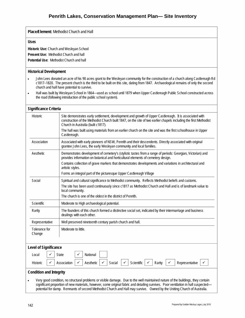
Penrith Lakes, Conservation Management Plan— Site Inventory
Prepared by Godden Mackay Logan, July 2010 142
Place/Element: Methodist Church and Hall
Uses Historic Use: Church and Wesleyan School Present Use: Methodist Church and hall Potential Use: Methodist Church and hall
Historical Development • John Lees donated an acre of his 90 acres grant to the Wesleyan community for the construction of a church along Castlereagh Rd
c1817–1820. The present church is the third to be built on this site, dating from 1847. Archaeological remains of only the second church and hall have potential to survive.
• Hall was built by Wesleyan School in 1864—used as school until 1879 when Upper Castlereagh Public School constructed across the road (following introduction of the public school system).
Significance Criteria Historic Site demonstrates early settlement, development and growth of Upper Castlereagh. It is associated with
construction of the Methodist Church built 1847, on the site of two earlier chapels including the first Methodist Church in Australia (built c1817). The hall was built using materials from an earlier church on the site and was the first schoolhouse in Upper Castlereagh.
Association Associated with early pioneers of NSW, Penrith and their descendents. Directly associated with original grantee John Lees, the early Wesleyan community and local families.
Aesthetic Demonstrates development of cemetery’s (stylistic tastes from a range of periods: Georgian, Victorian) and provides information on botanical and horticultural elements of cemetery design. Contains collection of grave markers that demonstrates developments and variations in architectural and artistic styles. Forms an integral part of the picturesque Upper Castlereagh Village
Social Spiritual and cultural significance to Methodist community. Reflects Methodist beliefs and customs. The site has been used continuously since c1817 as Methodist Church and Hall and is of landmark value to local community. The church is one of the oldest in the district of Penrith.
Scientific Moderate to High archaeological potential.
Rarity The founders of this church formed a distinctive social set, indicated by their intermarriage and business dealings with each other.
Representative Well preserved nineteenth century parish church and hall.
Tolerance for Change
Moderate to little.
Level of Significance
Local State National
Historic Association Aesthetic Social Scientific Rarity Representative
Condition and Integrity
• Very good condition, no structural problems or visible damage. Due to the well maintained nature of the buildings, they contain significant proportion of new materials, however, some original fabric and detailing survives. Poor ventilation in hall suspected—potential for damp. Remnants of second Methodist Church and Hall may survive. Owned by the Uniting Church of Australia.

Penrith Lakes, Conservation Management Plan—Site Inventory
Prepared by Godden Mackay Logan, July 2010 143
Place/Element: Methodist Church and Hall
Fabric Maintenance Guidelines
Church An inspection of the roof and rain water goods should be undertaken and damaged or missing fabric should be repaired or replaced as appropriate. Original fabric should be retained in situ wherever possible. Original joinery and carpentry to be retained in situ. Original windows and doors, including hardware to be retained in situ, and repaired as necessary. Internal and external walls should remain painted. When repainting in future ensure the selected colour scheme is based on analysis of earlier schemes. Regular inspections for water egress and termite activity should be undertaken.
Hall An inspection of the roof and rain water goods should be undertaken and damaged or missing fabric should be repaired or replaced as appropriate. Original fabric should be retained in situ wherever possible. Original joinery and carpentry to be retained in situ. Original windows and doors, including hardware to be retained in situ, and repaired as necessary. Internal and external walls should remain painted. Regular inspections for water egress and termite activity should be undertaken.
Clock Tower Retain in situ. Regular inspections and maintenance to be conducted as required.
Plantings Retain significant cultural plantings. Invasive weeds should be removed and a weed control program initiated.
Perimeter Plantings Retain in situ.
Post and rail fence Retain in situ. Reinstate gate.
Policy Recommendations: • A CMP should be prepared for the Upper Castlereagh Village Group. • Conserve character and fabric of place, including church, hall and cemetery. • Community uses such as present functions of the church, hall and cemetery should be retained. • Provide public access where possible and interpretive material to increase understanding and appreciation of heritage values. • No historic fabric or traditional plantings to be removed from site unless indicated in CMP. • Retain open views to the east—no scrub or tree plantings. Significant views within the Upper Castlereagh Village Group should be
conserved. • Any new structures in the vicinity of the church, hall and cemetery will require a Statement of Heritage Impact. • Development of the site, from Lees grant, to the construction of three churches and the various uses of the site should be
interpreted. The early function of hall as first school in the area should be interpreted. • Historic relationship with the Methodist Precinct and School group should be interpreted. • Sufficient curtilage must be established in order to retain the heritage values of the site and the traditional relationships between
the Upper Castlereagh Village Group along with the school group, visitors centre and café

Penrith Lakes, Conservation Management Plan— Site Inventory
Prepared by Godden Mackay Logan, July 2010 144
View from Old Castlereagh Road. (Source: GML 2007)
View of Clock tower, hall and Church, looking west towards Old Castlereagh Road. (Source: GML 2007)
Interior of Church. (Source: GML 2007)

Penrith Lakes, Conservation Management Plan—Site Inventory
Prepared by Godden Mackay Logan, July 2010 145
Place/Element: Methodist Cemetery
Location within the Scheme Area. Upper Castlereagh Village Group. Not to scale.
Location
• 1727 Old Castlereagh Road, in the southwest part of the Penrith Lakes Scheme area. The cemetery is located on the grounds of the Methodist Church and Hall (Part of Portion 71). The Church and associated cemetery lie within the Penrith Parish.
Description, Setting
• The cemetery covers an area of approximately 30mx53m, arranged in a simple nineteenth century formal cemetery layout. There are no central pathways, only minor grassed walkways and one paved walkway running north south.
• The cemetery contains approximately 90 monuments/grave surrounds, including cast and wrought iron palisade fence enclosures, sandstone and concrete kerbing and slabs. Upright sandstone slabs are the most common grave markers. Also found here are marble slabs and pedestals, a granite obelisk, and a marble column. Marble and granite headstone typically feature lead lettering. Most graves date from the nineteenth century, however some graves are dated as recently as 2003.
• Many headstones are of a simple Gothic design however some are more elaborate. Some earlier graves also have footstones. • The original grant owner John Lees is buried here. His remains were moved here in 1921 from the Castlereagh General Cemetery
(see photo). • The Methodist Church and Hall are located to the north. Parson’s accommodation is to the south (single storey structure). To the
west is the Blue Mountains, and the Sydney International Regatta centre lies to the east (with a quarry haulage road running between the lake and the cemetery boundary)
• The church and cemetery are enclosed by a boundary fence to the west, fronting Old Castlereagh Rd (comprising timber post sections and brick and galvanised iron section with an iron/wire gate), a lightweight mesh fence to the east, a hedge to the south (modern planting)
• The immediate setting/curtilage includes church and hall and Old Castlereagh Road. Picturesque views are afforded over the regatta lake to the east.
• The cemetery does not contain garden features with the exception of the lawn and hedge along southern border and some tree plantings around site boundary.
• According to previous studies conducted in 1987 and 1989 plantings include various bulbs (notably Ixias), English Box (Buxus Sempervirens), wild roses, Snowflake and Nacissus bulbs and Freesias amongst grave plots.

Penrith Lakes, Conservation Management Plan—Site Inventory
Prepared by Godden Mackay Logan, July 2010 146
Place/Element: Methodist Cemetery
Summary Statement of Significance • The Methodist cemetery is associated with the Methodist Church on Old Castlereagh Road, and forms and integral part of the
Upper Castlereagh Village Group comprising the church, cemetery, adjacent school and schoolmasters residence. This group is important as a related group forming the nucleus of a denominational community and village centre along Old Castlereagh Road. The Cemetery is a notable landmark visible from Old Castlereagh Road, which retains its nineteenth century rural cemetery character.
Uses Historic Use: Methodist cemetery Present Use: Methodist cemetery Potential Use: Methodist cemetery and public open space
Historical Development • John Lees donated an acre of his 90 acres grant to the Wesleyan community for the construction of a church along Old
Castlereagh Rd c1817–1820. The cemetery dates from 1836 (although Britton & Morris claim that the first burial that took place was in 1848).
• The present church is the third to be built on this site, dating from 1847. • John Lee’s died August 1836—originally buried in the Church of England cemetery in Castlereagh (also his wife Mary). Both
transferred to Methodist Cemetery in 1921.
Significance Criteria Historic Site demonstrates early settlement of Castlereagh. Associated with construction of the Methodist Church built 1847, on
the site of two earlier chapels including the first Methodist Church in Australia (built c1817).
Association Associated with early pioneers of NSW, Penrith and their descendents. Directly associated with original grantee John Lees, early Wesleyan community and local families buried here including the Purcells, Jacksons, Fields, Gormans, Parkers and Wrights. The graves of John Lees and the Church’s founders are located here.
Aesthetic Demonstrates development of cemetery’s (stylistic tastes from a range of periods: Georgian, Victorian) and provides information on botanical and horticultural elements of cemetery design. Contains collection of grave markers that demonstrates developments and variations in architectural and artistic styles. Forms an integral part of the picturesque Upper Castlereagh Village
Social Spiritual and cultural significance to Methodist community. Reflects Methodist beliefs and customs. Landmark value to local community.
Scientific Moderate to High archaeological potential. Provides important historic resource containing information on genealogical links and biographical details of early settlers of the region.
Rarity The early families buried here formed a distinctive social set, indicated by their intermarriage and business dealings with each other.
Representative Representative of early nineteenth century cemetery planning. Well preserved nineteenth century rural parish cemetery
Tolerance for Change
Moderate to little
Level of Significance
Local State National
Historic Association Aesthetic Social Scientific Rarity Representative
Condition and Integrity

Penrith Lakes, Conservation Management Plan—Site Inventory
Prepared by Godden Mackay Logan, July 2010 147
Place/Element: Methodist Cemetery
• Very good condition. Some broken headstones, some weathering noted. Several headstone inscriptions are no longer visible. Owned and managed by the Uniting Church of Australia.
•
Fabric Maintenance Guidelines Retain Fabric
Headstones Yes
Grave surrounds Yes
Walkways Yes
Plantings Yes
Yes
Fence Retain in situ. Yes
Policy Recommendations • Conserve character and fabric of place, including cemetery layout, grave markers, grave surrounds and other associated items. • Present role of cemetery should be retained. • Cemetery should be retained for community use, remain an open space precinct and continue use as a cemetery. • Unless associated with a new burial or specified in the CMP, modern materials should not be introduced. • New burials and their markers should be carefully sited and be of an appropriate design, form, scale and materials. • New materials may be necessary for interpretation/ presentation of unmarked graves. • No historic fabric or traditional plantings to be removed from site unless indicated in CMP. • All grave markers should be conserved in accordance with guidelines for the care and conservation of cemeteries by the BSE
Heritage Council and National Trust (NSW). • Significant views within the Upper Castlereagh Village Group should be retained. • Views to what was historically open space in east side should be retained. Retain open views to the east—no scrub or tree
plantings • An inventory of the site including broken grave markings and their surrounds, a record of inscriptions, and an archaeological survey
should be undertaken. • The historic relationship of the cemetery with the Upper Castlereagh Village group should be interpreted • Sufficient curtilage should be established, including the Upper Castlereagh Village group. • Retain and stabilise existing headstones. Regular maintenance should ensure that plantings and grasses do not interfere with their
structural integrity. Where headstones have fallen, retain in situ. • Grave surrounds should be retained in situ and where appropriate, repaired and stabilised. Wrought iron and cast iron surrounds
should be painted to prevent rusting and degradation of sandstone bases. Mortar repairs may be required for sandstone surrounds.
• Retain cleared walkways throughout the cemetery, according to its rectilinear design. • Regular maintenance should be undertaken to ensure plantings and grasses do not interfere with the structural integrity of
headstones, grave surrounds, and perimeter fencing. • Invasive weeds should be removed and weed control program initiated. • Retain perimeter plantings in situ. • Retain and conserve fence in situ.

Penrith Lakes, Conservation Management Plan—Site Inventory
Prepared by Godden Mackay Logan, July 2010 148
The Methodist Cemetery contains mostly sandstone headstones such as those seen above. The Upper Castlereagh School House and Residence can be seen on the western side of Old Castlereagh Road. (Source: GML 2007)
View East towards lake with family plot surrounded by cast iron surround in foreground. (Source: GML 2007)
The Methodist hall can be seen to the left of this picture, with views to the International Regatta Centre beyond the cemetery. (Source: GML 2007).
View towards Methodist Church and cemetery from Old Castlereagh Road. (Source: GML 2007)
Elaborate headstones. (Source: GML 2007)
Exhumation of John Lees 1921. (Source: Penrith City Council)

Penrith Lakes, Conservation Management Plan—Site Inventory
Prepared by Godden Mackay Logan, July 2010 149
Place/Element: Landers Inn
Location within the Scheme Area. Site plan, not to scale
Location
• Address is 1240 Old Castlereagh Rd. Located in northeastern part of the Penrith Lakes Scheme area (Part of Portion 43).
Description, Setting
• Set on a level grassed area, visible from Old Castlereagh Road. Area surrounding the site to the north, south and west has been extensively quarried. The Blue Mountains and the Nepean River are located to the west, beyond quarrying. Early fencelines indicate original grant. c1950s dairy and c1970s horse yards lie to the northwest.
• The Californian bungalow built c1920 features a hipped terracotta tiled roof and stretcher bond face brickwork. A verandah runs along the north east and south facades. A single storey extension has been built to the rear (western façade). The original layout of the nineteenth century inn has been retained within the California Bungalow, although the upper storey has been removed.
• Plantings include two mature Canary Island Date Palms (Phoenix canariensis) in the front garden. Other early twentieth century plantings include Skyduster (Washingtonie robusta), Poplars, Holley tree and Oleanders.
Summary Statement of Significance
• Landers Inn and stables (on Portion 43) is of State significance as one of the few remaining lots of the original 1803 land grants between Old Castlereagh Road and the Nepean River, and the only property to retain its authentic, significant connection to this important early road from Penrith to Richmond. The combination of the former inn, the stables and other small rural buildings on the site demonstrate the historical small rural uses of the area, from early crops and market gardens to dairying in the twentieth century.
• The history of the site is evident in its various components, including the mid-nineteenth century sandstone stables, and revealed in the fabric of the house (former inn) itself, which contains fabric from each of its periods of use (roadside inn, late nineteenth-century residence and early twentieth century bungalow). The Canary Island Date Palms (Phoenix canariensis) mark the entrance to the Landers Inn and are a significant visually distinguishing feature of the site.

Penrith Lakes, Conservation Management Plan—Site Inventory
Prepared by Godden Mackay Logan, July 2010 150
Place/Element: Landers Inn
Uses Historic Use: Inn, stables, farm and residence. Present Use: Residence (currently tenanted). Potential Use: Interpretive relic/residence/ visitors centre/ educational centre, family farm stay, farm gate produce (eg pick your own citrus/fruit orchard) public gardens, café, restaurant, private residence and farm.
Historical Development • Three phases of development: 1) inn and stables 2) California bungalow 3) extension to California bungalow and dairy structures • Located on part of 80 acre land grant from Governor King to Robert Smith in 1803, subsequently leased to Henry Stockfish, and in
1843 purchased by James Landers. House occupied by William Landers appears in 1873 survey of Castlereagh Road. Remained in ownership of Landers family until 1885, followed by a series of short term ownerships.
• Inn converted to a California Bungalow c1920s–1930s. The top storey of the inn was removed at this time (possibly had been damaged by fire?).
• Reportedly the Welcome Inn est on this site in 1841 (questioned by Siobhan Lavelle). Sources indicate James Landers was publican of ‘The Oddfellows Inn’ from 1844–1846—this is also contested by sources who claim that it was not built until 1864.
• Sandstone structure (stables) may have been a convict stockade or store, or housing for the men who constructed Old Castlereagh Road (according to Stedinger CMP).
Significance Criteria Historic Site demonstrates early settlement of Upper Castlereagh. Demonstrates various phases of development and
methods of construction.
Association Original grantee Robert Smith, Henry Stockfish and the Landers family. There is some anecdotal evidence that the stables may have formerly been a convict stockade, and therefore potentially associated with the construction of Old Castlereagh Road.
Aesthetic Picturesque rural setting.
Social Landmark value.
Scientific High archaeological potential.
Rarity As a mid nineteenth century inn contained within a twentieth century California Bungalow, this building is unique. Extremely rare remnants of the mid nineteenth century inn and stables survive in relatively good condition.
Representative Demonstrates characteristic colonial patterns of land use, settlement, travel and communication.
Tolerance for Change
Moderate to Little
Level of Significance
Local State National
Historic Association Aesthetic Social Scientific Rarity Representative
Condition and Integrity

Penrith Lakes, Conservation Management Plan—Site Inventory
Prepared by Godden Mackay Logan, July 2010 151
Place/Element: Landers Inn
• The California Bungalow is in good condition. While there are no visible structural problems general maintenance is required to avoid further deterioration. The stables are in poor condition. The upper storey/ loft poses particular danger and the structure requires immediate stabilisation.
• Considerable quarrying of surrounding area has disturbed its original context and setting. • Curtilage should include Old Castlereagh road and buffer along eastern side of Old Castlereagh road.
Fabric Maintenance Guidelines
Remnant Sandstone Stables Retain the existing stables in situ, including remnants of the upper storey. The structure should be stabilised. Ensure vegetation growth does not occur on or within the structure. Timber and masonry elements are to remain unpainted. Ensure adequate drainage, especially at the rear of the structure. May be adaptively re-used and interpreted.
Nineteenth Century Inn components
Retain in situ. Stabilise where necessary. No nineteenth century fabric should be removed or altered.
Twentieth Century California Bungalow components
Repair or replace rainwater goods and missing or broken terracotta roof tiles. Re-point brickwork. External brickwork should remain unpainted. Repair broken windows and paint all external timber elements such as window frames. Conduct regular inspections for water egress, termites etc.
Garden Retain.
Policy Recommendations:

Penrith Lakes, Conservation Management Plan—Site Inventory
Prepared by Godden Mackay Logan, July 2010 152
Place/Element: Landers Inn
• Prepare a CMP for Landers Inn. • Determine an appropriate curtilage to ensure an appropriate setting for the site is maintained. • Where possible ensure new boundaries reflect the alignments of historic land grant boundaries. • Retain the definition between the domestic landscape surrounding the buildings (ie garden) and the utilitarian landscape (ie
paddocks and grazing area). • Retain and conserve the character and fabric of the place including the inn, former stables, garden and plantings. • Prepare a dilapidation report for stables and maintenance schedule for Inn. • No historic fabric or traditional plantings to be removed from site unless indicated in CMP. • Senescent cultural plantings should be replaced with same or similar species. • Propagate new plantings from existing plant stock. • Maintain and conserve roadside plantings along Old Castlereagh Road. • Prepare a photographic archival recording prior to any works being carried out. • Where possibly, reinstate original levels of surrounding quarried land to retain sense of flat pastoral landscape. • Retain views to Hadley Park. • Maintain the historic alignment of Old Castlereagh Road. • Retain traditional site access from Old Castlereagh Road. • Interpret site, its significance and historic associations especially the role of roadside inns in providing rest and refreshment to
travellers/stock moving between settlements. • Any new structures in the vicinity of this site should require a Statement of Heritage Impact which should be reviewed against the
AMP and CMP. The development should fit with ongoing rural use.
View of Landers Inn and stables from Old Castlereagh Road (Source: GML 2007)
Remains of sandstone stables associated with Landers Inn. (Source: GML 2007)

Penrith Lakes, Conservation Management Plan—Site Inventory
Prepared by Godden Mackay Logan, July 2010 153
Holding pens at the rear of the sandstone stables. (Source: GML 2007)
View of the California Bungalow residence and front garden, containing remains of a mid nineteenth century inn, and front garden, from the driveway. (Source: GML 2007)
View of the rear extension to Landers Inn. (Source: GML 2008)
View of the front garden from Old Castlereagh Road. (Source: GML 2007)

Penrith Lakes, Conservation Management Plan—Site Inventory
Prepared by Godden Mackay Logan, July 2010 154
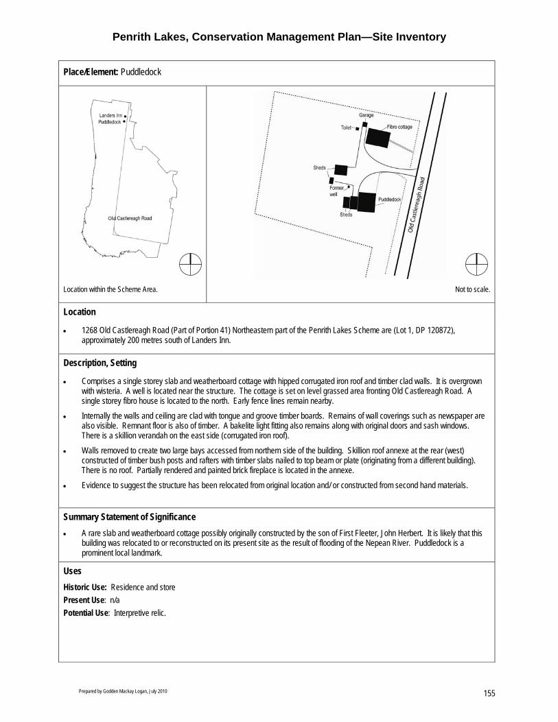
Penrith Lakes, Conservation Management Plan—Site Inventory
Prepared by Godden Mackay Logan, July 2010 155
Place/Element: Puddledock
Location within the Scheme Area. Not to scale.
Location
• 1268 Old Castlereagh Road (Part of Portion 41) Northeastern part of the Penrith Lakes Scheme are (Lot 1, DP 120872), approximately 200 metres south of Landers Inn.
Description, Setting
• Comprises a single storey slab and weatherboard cottage with hipped corrugated iron roof and timber clad walls. It is overgrown with wisteria. A well is located near the structure. The cottage is set on level grassed area fronting Old Castlereagh Road. A single storey fibro house is located to the north. Early fence lines remain nearby.
• Internally the walls and ceiling are clad with tongue and groove timber boards. Remains of wall coverings such as newspaper are also visible. Remnant floor is also of timber. A bakelite light fitting also remains along with original doors and sash windows. There is a skillion verandah on the east side (corrugated iron roof).
• Walls removed to create two large bays accessed from northern side of the building. Skillion roof annexe at the rear (west) constructed of timber bush posts and rafters with timber slabs nailed to top beam or plate (originating from a different building). There is no roof. Partially rendered and painted brick fireplace is located in the annexe.
• Evidence to suggest the structure has been relocated from original location and/ or constructed from second hand materials.
Summary Statement of Significance • A rare slab and weatherboard cottage possibly originally constructed by the son of First Fleeter, John Herbert. It is likely that this
building was relocated to or reconstructed on its present site as the result of flooding of the Nepean River. Puddledock is a prominent local landmark.
Uses Historic Use: Residence and store Present Use: n/a Potential Use: Interpretive relic.

Penrith Lakes, Conservation Management Plan—Site Inventory
Prepared by Godden Mackay Logan, July 2010 156
Place/Element: Puddledock
Historical Development • Located on part of 80 acre land grant from Governor King to Gilbert Goodlet in 1803, subsequently leased to John Herbert in 1806
(ownership later transferred to Herbert in 1811). In 1825 the property was divided into 16 acre shares for John Herbert’s 5 sons. • Extant structure possibly constructed by James Herbert in 1870s. Perkins descendents (occupiers of site since 1943) suggests the
structure was moved to its present location, on more elevated land away from flood waters in the 1920s and 1930s. Daphne Kingston, in her book, Highways and Byways of the Sydney Region states the cottage was moved in 1912. The cottage was reputedly reconstructed in the 1930s by Bob Perkin’s father. Bob Perkins was a former owner and local resident.
Significance Criteria Historic Site demonstrates early settlement of Upper Castlereagh.
Association Original grantee Gilbert Goodlet, John Herbert and the Herbert family as well as the Perkins family.
Aesthetic Picturesque rural setting retained. Interesting example of vernacular building type, once common in this area. Landmark value.
Social Community interest and attachment to site.
Scientific Some archaeological potential.
Rarity Rare surviving early slab cottage As a building comprised of various other buildings this building is unique
Representative Characteristic of early modest dwellings found in Castlereagh and of Depression era improvised .
Tolerance for Change
Little
Level of Significance
Local State National
Historic Association Aesthetic Social Scientific Rarity Representative
Condition and Integrity
• Very poor condition. Evidence of termite attack.
• Severe structural failure—ceiling collapsing, verandah roof collapsing, annexe badly deteriorated.
• Rare slab structure.
• Owned by PLDC. Listed in Penrith LEP.

Penrith Lakes, Conservation Management Plan—Site Inventory
Prepared by Godden Mackay Logan, July 2010 157
Place/Element: Puddledock
Policy Recommendations If retained • Retain and conserve the structure as a standing ruin in-situ. • Consider incorporating significant fabric associated with Puddledock as part of on-site interpretation. • An HIS should be prepared prior to commencement of any works that may impact on the heritage significance of the site. • All fabric in a reasonable condition should be retained. • Retain open setting. • Prune wisteria. • Any new structures in the vicinity of this site should require a Statement of Heritage Impact. If not retained • If retention is not feasible, prepare a photographic archival recording prior to any works being carried out. • Significant fabric should be salvaged and conserved. • Samples of wallpapers and other ephemera associated with the site should be conserved and securely stored. General • Moveable heritage should be secured, retained and interpreted. • Observe the conditions of consent in DA 4.
View from Old Castlereagh Road. (Source: GML 2007)
View from driveway. (Source: GML 2007)

Penrith Lakes, Conservation Management Plan—Site Inventory
Prepared by Godden Mackay Logan, July 2010 158
Interior—front rooms. (Source: GML 2007)
Interior—rear (note fireplace/ stove). (Source: GML 2007)
Remnants of wallpaper. (Source: GML 2007)
Associated fibro cottage. (Source: GML 2007)

Penrith Lakes, Conservation Management Plan—Site Inventory
Prepared by Godden Mackay Logan, July 2010 159
Place/Element: The Poplars
Location within the Scheme Area. (Source: GML 2008)
Location
• Eastern part of the Scheme area (Part of Portion 80, Lot 2, DP 229462) approx 950 metres west of Castlereagh Road.
Description, Setting
• Comprised of a large isolated residential allotment containing ruins of a Pise House, two timber slab cottages, a small ashlar rendered mass concrete outbuilding and two modern corrugated iron sheds and garage. The structures are scattered across the allotment amongst dense vegetation.
• Both slab structures are clad with corrugated iron. The earliest structure was used as stables and the second slab structure was used as a garage until recently. The Pise House contains three rooms with a hipped corrugated iron roof, a brick chimney and a verandah. Also located on the site is a mass concrete outbuilding approx 80 years old.
• The garden contains a significant variety of non-indigenous plantings including; Yunnan Poplar (Populus yunnanensis), Golden Elm (Ulmus procera ‘Louis van Houtte’), Yellow, Verigated and Plain Elm (Elmus), Jacaranda (Mimosifolia), Kauri Pine (Agathis robusta), Bunya Pine (Araucaria bidwillii), Oleander (Nerium), Chinese Fan Palm (Liyistona chinesis), Firewheel (Stenocarpus sinuatus) and Cactus (cacti). Most of the vegetation is mature and overgrown. Noxious weeds are also present. Although highly visible from many locations, the overgrown vegetation prevents views inside the property.
• The site was previously accessed from Farrells Lane; however, it is now surrounded by quarrying.
Summary Statement of Significance • The Poplars comprises a densely vegetated allotment containing remains of a private residence and associated outbuildings. It is
an important landmark in the Penrith Lakes Scheme landscape, providing a reference point from various locations.
Uses Historic Use: Formerly part of a larger farming grant and private residence. Present Use: Vacant. Potential Use: Public open space, public gardens/plant nursery developed in partnership with Botanic Gardens Trust, private leasehold with public open days annually.

Penrith Lakes, Conservation Management Plan—Site Inventory
Prepared by Godden Mackay Logan, July 2010 160
Place/Element: The Poplars
Historical Development • Located on part of the 150 acres originally granted to Rosetta Marsh in 1809, who later married and became Rosetta Terry. The
property (then known as ‘Islington’) was inherited by daughter Maria Foxglove Hosking in 1845. The first slab structure is thought to have been built around this time (pre 1850).
• In 1875 the western portion of ‘Islington’ comprising 100 acres was purchased by Richard Cosgrove. The property was later sold to Edward Cass in 1905, who is likely to have constructed the second slab cottage.
• The 100 acre property was purchased by Andrew Salmond in 1921. He is thought to have constructed the Pise house in 1922. • Much of the garden was planted in the 1930s from cuttings that were collected from the local area and seeds that were obtained
from the Royal Botanic Gardens, Sydney. It was not formally planned. • Following WWI, Poplars were commonly planted in commemoration of battles fought in France, reaching their peak between the
1920s and 1940s. • Property remained in Salmond family ownership until 1962 when the land, except for the house allotment, was sold to Rio Pioneer
Gravel. The house was sold at this time to DUAP (NSW Dept of Planning). The property is not in PLDC ownership.
Significance Criteria Historic Demonstrates early settlement of the Castlereagh area.
Demonstrates through fabric and layout phases of use from earliest European settlement through the nineteenth and early twentieth century agricultural expansion when smaller land holdings appeared in the area with development of dairy farming.
Association Original grantee Rosetta Marsh and husband Samuel Terry, Maria Foxglove Hosking, Richard Cosgrove and Edward Cass. Also has long associations with the Salmond family. Important traditional address to the line of Olives at Mount Pleasant.
Aesthetic Prominent landmark and reference point in the landscape. Plant species are distinctive.
Social Landmark value. Poplar plantings associated with commemoration of battles fought in France during World War One, (reaching their peak between the 1920s and 1940s)
Scientific Demonstrates early construction materials and techniques High archaeological potential.
Rarity Pise House is rare at a local level.
Representative Plant species in the garden are representative of tastes and characteristics of gardens of the 1930s and 1940s. The site is representative of nineteenth and early twentieth century agricultural settlements of the Castlereagh area.
Tolerance for Change
Moderate
Level of Significance
Local State National
Historic Association Aesthetic Social Scientific Rarity Representative
Condition and Integrity • The site’s original context and rural landscape has been significantly impacted by quarrying activities. • The Pise house is structurally unsound. Repairs are necessary. • The slab structures are reasonably intact but in poor condition. • The garden requires significant catch-up maintenance, particularly in terms of weed management. • The site is owned by NSW Dept of Planning.

Penrith Lakes, Conservation Management Plan—Site Inventory
Prepared by Godden Mackay Logan, July 2010 161
Place/Element: The Poplars
Fabric Maintenance Guidelines
Pise house Urgent maintenance is required to repair damaged building fabric resulting from rising damp and termite activity. The brick chimney on the northern façade requires urgent stabilisation and repair. An inspection of the roof and rain water goods should be undertaken and damaged or missing fabric should be repaired or replaced as appropriate. Original fabric should be retained in situ wherever possible. A buffer between the house and vegetation should be established.
Slab Cottages Remove vegetation. Stabilise or replace water and termite damaged timbers, particularly in roof. Retain corrugated iron where possible. Ensure weather tightness.
Mass Concrete outbuilding Retain and stabilise where possible.
Entry Drive Reinstate original entry drive if possible.
Garden Undertake Arborist’s assessment and analysis. Retain all significant plantings. Rid garden of pests. Maintain garden and implement weed management system.
Policy Recommendations: • Resolve ownership and future use of the property. • Prepare a CMP for the property. • Obtain advice from an arborist to identify, map and audit plant species. • Prepare and implement a garden management plan. • Retain and conserve the character and fabric of the place including the Pise House and slab cottage. • Carry out regular inspections to monitor weeds and pests. • Implement weed and pest management. • Prepare a dilapidation report and maintenance schedule. • Establish appropriate buffer zone around the site. • No historic fabric or traditional plantings to be removed from site unless indicated in a CMP or following an arborist’s advice. • Retain significant views, such as those to and from McCarthy’s Cemetery, the escarpments and to the area where Mount Pleasant
the olive farm owned by Samuel Terry and Rosetta Marsh was located. • Reinstate or interpret the relationship to Farrells Lane. • Any new development in the vicinity of this site should retain generous setbacks from the curtilage of The Poplars of a minimum of
20 metres. • The scale and bulk of new development should not detract from the significance of The Poplars. • The history and heritage of The Poplars should be interpreted.

Penrith Lakes, Conservation Management Plan—Site Inventory
Prepared by Godden Mackay Logan, July 2010 162
The Poplars viewed from outside the site boundary. Due to the dense vegetation views within the property are not available. (Source: GML 2007)
Pise residence c1922. (Source: GML 2007)
The earliest slab structure, thought to predate 1850. (Source: GML 2007)
The second slab structure. (Source:GML 2007)
Mass concrete outbuilding, possibly a former dairy. (Source:GML 2007)

Penrith Lakes, Conservation Management Plan—Site Inventory
Prepared by Godden Mackay Logan, July 2010 163
Place/Element: Mass Concrete House (also known as 43 Smith Road and Howell’s House)
Location within the Scheme Area. Front façade with an original wrap return verandah featuring cast iron columns. (Source: GML 2007)
Location
• 43 Smith Road (or 95 Old Castlereagh Road), located in the northern portion of the Penrith Lakes Scheme area (Part of Portion 42).
Description, Setting • The building comprises a late-Victorian cottage constructed in three different phases: 1) c1900, 2) c1902 and 3) c1957–1972. It
is constructed of mass concrete using a sand/cement mix and large river pebbles sourced locally. All external and internal mass concrete walls are painted.
• The main cottage features a hipped and gabled Marseille-pattern, terracotta tiled roof with a rear (western) wing featuring a Klip-lok metal and polycarbonate roof. Fascia boards are modern, simple and undecorated.
• An L-shaped or ‘wrap-around’ verandah is located at the north east and south of the cottage. This was an original feature but altered c.1950 with an un-reinforced concrete floor inserted. The verandah features late Victorian cast iron columns relocated atop face brick balustrade wall. Entry steps to the eastern verandah have been removed and modern concrete blocks, roughly formed, have been used.
• The building retains most of its original doors and windows, including a pair of half-glazed panelled, Victorian French doors. External raised render trim has been used at window and door openings.
• Associated outbuildings on the site include: − A small Klip-lok roofed fibro toilet structure, c1957 − Timber framed corrugated iron clad garage, c1930 − Timber and metal framed corrugated non iron storage shed, c1950s having a mono-pitch roof and is a transportable structure − A metal and timber framed farm machinery shed c1970 which is open at its eastern end and attached to a large timber and
metal framed corrugated iron clad storage and machinery shed c1920 having a gable roof form − A fibro clad garage, three galvanized iron farm sheds and a small fibro toilet facility of modern construction. − A former 1970s Dairy structure comprising a battened fibro gable form with corrugated iron roof
• Other external elements include metal and wire fencing and small areas of retaining walls at the west of the cottage. • The site is located beside a number of wetland areas and associated natural vegetation related to the drainage pattern of the
floodplain. It is situated in an area of high Aboriginal Archaeological significance.

Penrith Lakes, Conservation Management Plan—Site Inventory
Prepared by Godden Mackay Logan, July 2010 164
Place/Element: Mass Concrete House (also known as 43 Smith Road and Howell’s House)
• The house is associated with a garden of Cypresses, Pines and Kurrajongs likely established at the same time as house was constructed. A Crepe Myrtle and Monteray Pine are located in front of the main house.
• Views from the main house to the Nepean River, and to Hadley Park and Landers Inn.
Summary Statement of Significance • This site contains a twentieth century dwelling built using mass concrete. The dwelling was constructed in three stages ranging
from 1900 to 1972. Adjoining Smith Road this site overlooks wetlands and Cranebrook Creek to the south.
Uses Historic Use: Residence, farm and homestead. Present Use: Vacant Potential Use: Lease as private dwelling, farm and homestead or establish as an environmental education centre.
Historical Development • Located on part of the original 160 acre grant to Donald Kennedy in 1803. The Kennedy farm was visited by Governor Macquarie
and his wife in 1810. Following Donald Kennedy’s death, 40 acres was passed on to each of the three surviving Kennedy sons, but by 1835 all 160 acres was owned by two of the sons, Duncan and Daniel. The land was gradually mortgaged and subdivided but in 1843 Robert Ritchie (husband of the Kennedy’s daughter, Ann) purchased the whole160 acres. The land remained in the family until 1884 when the property was subdivided into four smaller farms (of 40 acres each).
• The portion of the grant on which the Mass Concrete House (at 43 Smith Road) now stands was that passed to George Howell III. c1900 George Howell III began constructing a mass concrete house, identical to that constructed by his son, William (since demolished). In 1902, before the house was completed, both George and his wife died. The 40 acre grant with the incomplete house was inherited by their youngest son, Athol Colless Howell. Athol Colless Howell built two wings on the western side, completing the Mass Concrete House by the end of 1902.
• Athol Colless Howell established a successful citrus orchard on the property, grew vegetables and began dairy farming. He died in 1952 and bequeathed the 40 acre property to his wife Minnie. Upon her death in 1956, the property passed to son Athol Robert Howell.
• In 1965, Athol Robert Howell sold the land out of the family to Alan and Evelyn Petherbridge. The couple sold the property on to Leslie George Schaefer shortly after, who sold to Mary Halleen. In June 1975 the property was sold to Quarries Pty Ltd.
Significance Criteria Historic Demonstrates phases of use from the earliest European settlement activities through the late nineteenth and
early twentieth century agricultural expansion to the present.
Association Original grantee Donald Kennedy, Governor Macquarie and wife, and the Howell family.
Aesthetic Picturesque rural setting.
Social
Scientific Moderate to High archaeological potential.
Rarity Site comprises a rare surviving valley farm.
Representative Demonstrates early twentieth century phase of increased small land holdings in the Castlereagh area, with the development of local dairy farming, market gardening and orcharding. Representative of the use of mass concrete in the Castlereagh area, utilising locally available materials.
Tolerance for Change
Moderate
Level of Significance

Penrith Lakes, Conservation Management Plan—Site Inventory
Prepared by Godden Mackay Logan, July 2010 165
Place/Element: Mass Concrete House (also known as 43 Smith Road and Howell’s House)
Local State National
Historic Association Aesthetic Social Scientific Rarity Representative
Condition and Integrity
• Poor condition but no obvious evidence of building failure settlement or cracking. Water damage caused by rising damp, however, is noted in all rooms of the cottage and in some places is quite extensive (NB No damp proof course). Floors missing in most rooms, repairs to roof needed.
Fabric Maintenance Requirements
Corrugated Iron roof cladding Repair and reconstruct all roofs including chimneys, ridge cappings, flashings and rain water goods.
Walling Install physical barrier damp-proof system to all internal and external walls. Paint internal walls. Reinstate original timber weatherboard cladding to rear western wing courtyard walls.
Ceilings Reinstate throughout. Paint.
Windows and doors Reinstate missing windows and doors, including hardware. External timber elements should be painted. Regular inspections for termite activity should be undertaken
Flooring Remove concrete slab flooring. Reinstate flooring throughout.
Intrusive elements Remove intrusive elements identified in the Mass Concrete House CMP, March 2007.
Policy Recommendations • Retain, conserve and interpret the mass concrete house, including its layout and setting including associated outbuildings, fence
lines, former orchard and other plantings in accordance with the policies and recommendations of the Mass Concrete House CMP and Schedule of Works March 2007.
• No historic fabric or traditional plantings to be removed from site unless indicated in CMP. • Retain views to Landers Inn, Hadley Park and the Nepean River. • Establish a curtilage that encompasses all elements that contribute to the heritage significance, conservation and interpretation of
the house and its site. • Selected European plantings of exotic species, such as Cypress, and fruit trees of the former orchard should be interpreted. • Record and where possible retain moveable items insitu. • The construction of new structures or demolition of existing structures on this site should require a Statement of Heritage Impact. • New work should be clearly contemporary and designed to complement the existing rural character. • Further historic research and archaeological investigation involving minor excavation may be undertaken (subject to excavation
permit application—section 140) • Interpret the history and heritage of the property as part of future development.

Penrith Lakes, Conservation Management Plan—Site Inventory
Prepared by Godden Mackay Logan, July 2010 166
Mature cultural plantings at entry to the site. (Source: GML 2007)
View of the house form the south. (Source: GML 2007)
Rear of the main house showing the courtyard. (Source: GML 2007)
Interior, c1970s kitchen. (Source: GML 2007)
Shed containing moveable heritage items, catalogued. (Source: GML 2007)
Setting, looking southwest. (Source: GML 2007)

Penrith Lakes, Conservation Management Plan—Site Inventory
Prepared by Godden Mackay Logan, July 2010 167
Place/Element: Jackson’s Ford
Location within the Scheme Area. Taken Jackson's Ford on the Nepean River. (Source:GML 2007)
Location
• Jackson's Ford is located on Part of Portion 54, on part of the original 100 acre grant made to Edward Field in 1803. The land was purchased by John Jackson in 1867.
Description, Setting
• Jackson's Ford is formed from river pebbles laid across a shallow flat portion of the Nepean River. A track leads down to the ford on its east side. It is distinguished by cuttings into the river bank on either side of the river.
Summary Statement of Significance • Jackson’s Ford is the only remaining nineteenth century river crossing for cattle and stock in the Penrith Lakes Scheme area. It
provides evidence of nineteenth century farming practices and travel routes in this area, and retains its original use today.
Uses Historic Use: River crossing for cattle Present Use: River crossing Potential Use: River crossing (pedestrian only)
Historical Development • Several river fords were built across the Nepean River to provide access to adjoining farmlands and roads as part of colonial travel
routes and river crossings in the Castlereagh area. • Fords were used to drive cattle up the ridges to grazing land on the higher west bank of the river and into the Blue Mountains. Egs:
Jackson's Ford (RES 62), Single's Fords (RES 63) Sheen's Lane Ford (RES 61), and Long's Lane Ford (RES 60) • Jackson's Lane (RES 59) was a gravel surfaced road leading west from Old Castlereagh Road to the Nepean River dating from the
early years of the settlement in the Penrith district. Part of this lane survives near the river crossing and, like many lanes, forms part of the original subdivision pattern. At its western end, the lane descends through a steep cutting in the high bank down to the edge of the Nepean River to Jackson's Ford. The ford is a part of this lane and early land use.
• Jackson's Ford is also associated with Jackson's House. This weatherboard cottage was still sited on the riverbank at the end of Jackson's Lane in 1983. It was demolished in 1997 leaving only part of its fence.

Penrith Lakes, Conservation Management Plan—Site Inventory
Prepared by Godden Mackay Logan, July 2010 168
Place/Element: Jackson’s Ford
Significance Criteria Historic Demonstrates early settlement of the Castlereagh area.
Demonstrates important part of the settlement history of the locality particularly in terms of the role of grazing and the Nepean River. Early example of specialised land utilisation. Constitutes evidence of colonial travel routes and river crossings that are still in use today.
Association Original grantee Edward Field, and John Jackson, whom the ford is named after. Associated with three other known Ford’s (former Single’s Ford located west of Nepean Park, Sheen’s Lane Ford located to the south, outside Scheme area and Long's Lane Ford, located further east, outside SE boundary of Scheme area) Associated with surrounding farms.
Aesthetic Picturesque rural setting.
Social Of central importance to the every day existence of local graziers who relied on the ford to transport stock.
Scientific Low archaeological potential.
Rarity Highly intact. The only remaining ford in the scheme area (and possibly the Castlereagh region)
Representative Characteristic of river crossings used by early Castlereagh farmers to transport stock across the river.
Tolerance for Change
Low.
Level of Significance
Local State National
Historic Association Aesthetic Social Scientific Rarity Representative
Condition and Integrity • Jackson's Ford remains intact and in use. It is located within a Conservation Area. Tyres have been placed along the crossing to
protect the Ford from damage caused by vehicles.
Policy Recommendations: • Jackson’s Ford should be retained and conserved in situ. • The site should be interpreted in relation to other early river crossings and stock routes. • Weed management should be instigated. • Measures taken to stop vehicle use of crossing.

Penrith Lakes, Conservation Management Plan—Site Inventory
Prepared by Godden Mackay Logan, July 2010 169
Place/Element: Longs House
Location within the Scheme Area. Longs House and garden. (Source: GML 2007)
Location
• Located in the Penrith Lakes Development Corporation operational area in the southern part of the scheme area (Part of Portion 89).
Description, Setting
• Long’s Cottage (a house formerly in the ownership of Mr Allan Long) is a single-storey residence with garden, built at the beginning of the twentieth century on the largest of the original land grants in the Castlereagh area. The house is set on what was the southernmost boundary of the original property, fronting the north side of Old Castlereagh Road. Its current location is at the entrance to the Penrith Lakes Scheme’s Head Office, adjacent to and houses the Muru Mittigar Aboriginal Cultural and Educational Centre.
• Federation-style residence featuring exposed red brown double face brick wall and three decorative brick chimneys. The roof has been reclad with green corrugate iron. It also features new guttering. On the east and south sides of the building a bull nose verandah has been enclosed using aluminium sliding windows and fibro cladding for the ceiling. A modern entrance with awing has been fitted to the north side. The house has been fitted with a modern kitchen.
• Setting includes Penrith Lakes Scheme office complex, a bitumen car park, colorbond clad warehouse, various other small buildings, a plant nursery and other modern facilities. A garden has been established beside the house.
Summary Statement of Significance
• Demonstrates early twentieth century settlement in the Castlereagh area (historical significance). • Has associations with the Long family (Allen Long was a son of Michael Long, Mayor of Penrith), while the site itself has
associations with the original land grantee (William Chapman) and other settlers (including early settler John McHenry) (associative significance).
• Is a Federation style residence that contributes to the character of the area (aesthetic significance). • Is presently used by Muru Mittigar and has active and important social uses (social significance). • Has the potential to yield information through its potential archaeological resource (scientific significance). • Is a rare surviving historic built element within the Penrith Lakes Scheme area (rarity significance). • Is a good example of a Federation style house in the area despite recent alterations (representative significance).

Penrith Lakes, Conservation Management Plan—Site Inventory
Prepared by Godden Mackay Logan, July 2010 170
Place/Element: Longs House
Uses Historic Use: Residence. Present Use: Café, shop and offices. Potential Use: Café, restaurant, shop, office, residence, meeting rooms.
Historical Development • Situated on part of 1300 acres granted to William Chapman in 1804. Chapman never occupied the property and by 1820 only 32
acres had been cleared. The property was reportedly occupied by squatters, who may have been responsible for the clearing. It was a squatter, John McHenry, who purchased the property in 1828.
• 1827 McHenry built a house on the northern edge of the property. The property was named ‘Lemongrove’. Following his death in 1831 the property was tenanted until his sons were old enough to farm the property in the 1850s.
• During the 1860s the property was subdivided and by 1873 it was owned by 5 different families. Many of the subsequent owners are buried in McCarthy’s cemetery.
• By 1947 the majority of the property was being farmed and had been cleared. • Allen Long’s house and outbuildings date from c20th century. Allen Long was the son of the former Mayor of Penrith, Michael
Long. • Longs house was used as a gravel company office during the 1980s. • Most of the original land grant is occupied by the Sydney Regatta Centre and the PLDC office/headquarters.
Significance Criteria
Historic Demonstrates early settlement in the Castlereagh area.
Association Original grantee William Chapman and McHenry and Long families.
Aesthetic Some aesthetic significance as a Federation style residence that contributes to the character of the area.
Social Significant community value associated with use by Muru Mitigar Aboriginal Cultural and Educational Centre.
Scientific
Rarity Rare surviving built element within the Penrith Lakes Scheme area. Located on the single largest grant portion within the valley.
Representative Representative of a Federation-style house.
Tolerance for Change
High.
Level of Significance
Local State National
Historic Association Aesthetic Social Scientific Rarity Representative
Condition and Integrity
• The building is in good condition and is well maintained. Although the building has been modified original fabric remains. No immediate maintenance measures or repairs are required.
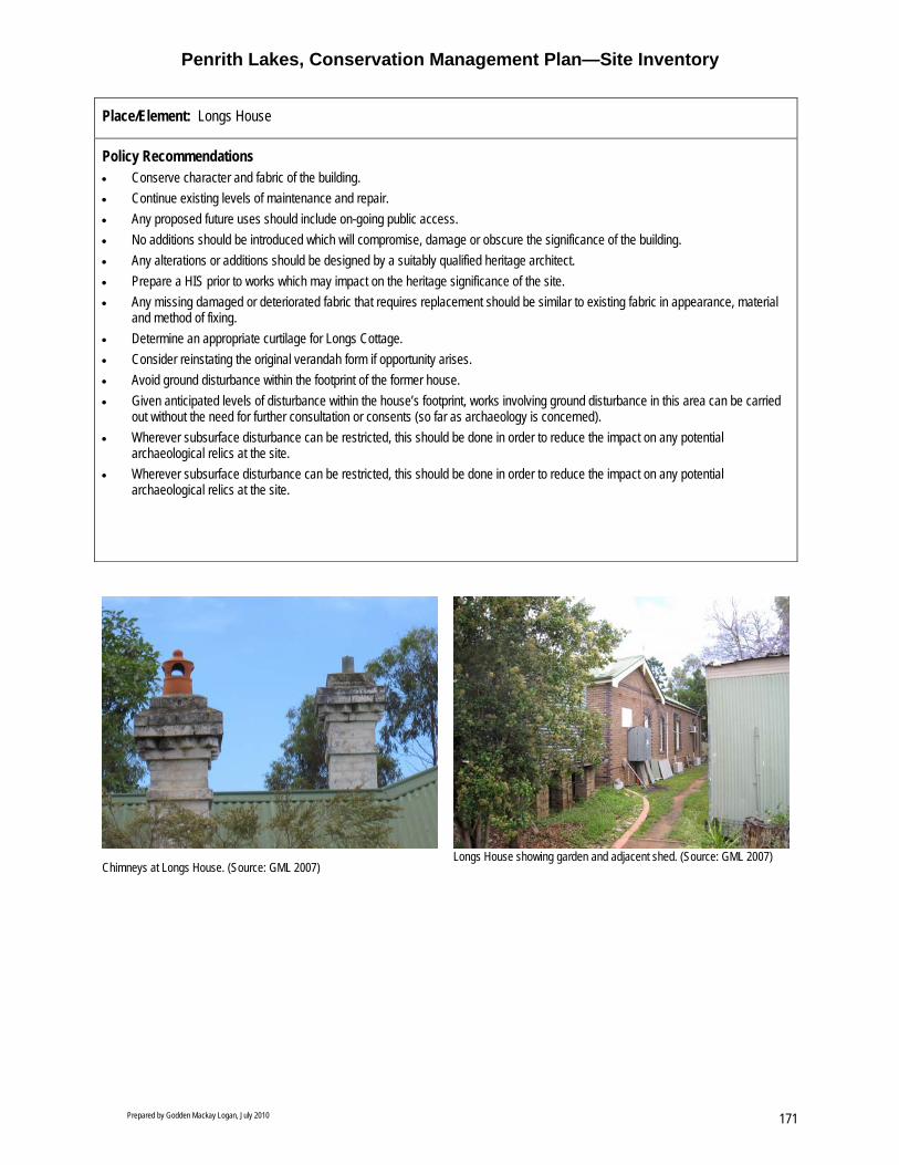
Penrith Lakes, Conservation Management Plan—Site Inventory
Prepared by Godden Mackay Logan, July 2010 171
Place/Element: Longs House
Policy Recommendations • Conserve character and fabric of the building. • Continue existing levels of maintenance and repair. • Any proposed future uses should include on-going public access. • No additions should be introduced which will compromise, damage or obscure the significance of the building. • Any alterations or additions should be designed by a suitably qualified heritage architect. • Prepare a HIS prior to works which may impact on the heritage significance of the site. • Any missing damaged or deteriorated fabric that requires replacement should be similar to existing fabric in appearance, material
and method of fixing. • Determine an appropriate curtilage for Longs Cottage. • Consider reinstating the original verandah form if opportunity arises. • Avoid ground disturbance within the footprint of the former house. • Given anticipated levels of disturbance within the house’s footprint, works involving ground disturbance in this area can be carried
out without the need for further consultation or consents (so far as archaeology is concerned). • Wherever subsurface disturbance can be restricted, this should be done in order to reduce the impact on any potential
archaeological relics at the site. • Wherever subsurface disturbance can be restricted, this should be done in order to reduce the impact on any potential
archaeological relics at the site.
Chimneys at Longs House. (Source: GML 2007)
Longs House showing garden and adjacent shed. (Source: GML 2007)

Penrith Lakes, Conservation Management Plan—Site Inventory
Prepared by Godden Mackay Logan, July 2010 172

Penrith Lakes, Conservation Management Plan—Site Inventory
Prepared by Godden Mackay Logan, July 2010 173
Place/Element: Gravel Plant Ruins
Location within the Scheme Area. Friction wheel associated with the former Mill. (Source: GML 2007)
Location
• Located on the western boundary of the Scheme about 80 metres east of the Nepean River, north of Jackson’s Ford (Part of Portion 54).
Description, Setting
• Ruins comprising a long concrete trench extending approximately 12 metres in length and 1.2 metres in depth, with remains of solid concrete walls and concrete footings. Remains of a boiler provide evidence of a steam engine located at the southern end of the former mill. A friction wheel mounted on an axle also remains. The site is overgrown.
Summary Statement of Significance
• Remains of an early twentieth century gravel plant on the banks of the Nepean River
Uses Historic Use: Gravel Plant Present Use: n/a Potential Use: Interpretive device. Use varied following archaeological investigation.
Historical Development • Part of the original 100 acre grant to Edward Field in 1803, inherited by William Field in 1825. In 1847 30 acres of the northwestern
portion of Field’s grant was sold to Joseph Collit who subsequently sold his land to John Jackson in 1867, who had previously already purchased 50 acres of the southern portion of the original grant in 1865.
• In 1937 Nena May Jackson inherited the land, leasing 23 acres along the riverfront to Industrial Metal and Gravel (Nepean) Ltd. In 1947 she sold 97 acres to Quarries Pty Ltd.
• Dates from c1920s–1930s. No historic research specific to this site is available.
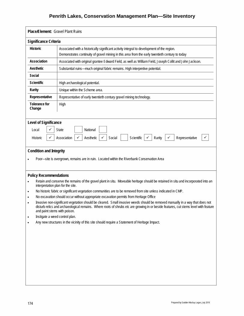
Penrith Lakes, Conservation Management Plan—Site Inventory
Prepared by Godden Mackay Logan, July 2010 174
Place/Element: Gravel Plant Ruins
Significance Criteria
Historic Associated with a historically significant activity integral to development of the region. Demonstrates continuity of gravel mining in this area from the early twentieth century to today
Association Associated with original grantee Edward Field, as well as William Field, Joseph Collit and John Jackson.
Aesthetic Substantial ruins—much original fabric remains. High interpretive potential.
Social
Scientific High archaeological potential.
Rarity Unique within the Scheme area.
Representative Representative of early twentieth century gravel mining technology.
Tolerance for Change
High
Level of Significance
Local State National
Historic Association Aesthetic Social Scientific Rarity Representative
Condition and Integrity
• Poor—site is overgrown, remains are in ruin. Located within the Riverbank Conservation Area
Policy Recommendations • Retain and conserve the remains of the gravel plant in situ. Moveable heritage should be retained in situ and incorporated into an
interpretation plan for the site. • No historic fabric or significant vegetation communities are to be removed from site unless indicated in CMP. • No excavation should occur without appropriate excavation permits from Heritage Office • Invasive non-significant vegetation should be cleared. Small invasive weeds should be removed manually in a way that does not
disturb relics and archaeological remains. Where roots of shrubs etc are growing in or beside features, cut stems level with feature and paint stems with poison.
• Instigate a weed control plan. • Any new structures in the vicinity of this site should require a Statement of Heritage Impact.

Penrith Lakes, Conservation Management Plan—Site Inventory
Prepared by Godden Mackay Logan, July 2010 175
Ruins of the former Mill (Source: GML 2007)
Remains of concrete wall. (Source: GML 2007)
Remains of a boiler associated with the former Mill (Source: GML 2007)
Friction wheel. (Source: GML 2007)

Penrith Lakes, Conservation Management Plan—Site Inventory
Prepared by Godden Mackay Logan, July 2010 176

Penrith Lakes, Conservation Management Plan—Site Inventory
Prepared by Godden Mackay Logan, July 2008 177
Place/Element: Fulton’s Parsonage
Location within the Scheme Area. 1969 parish map showing Lot 99 ‘Glebe’ on the southwest corner of the Castlereagh grid. The parsonage was located in the north of this lot.
Location
• The Fulton’s Parsonage site was part of a land grant (Portion 99) made to the Reverend Henry Fulton which became part of a 400 acre church glebe. The parsonage itself was located atop sloping ground on the southwest corner of the Castlereagh grid.
Description, Setting
• Archaeological remains associated with Fulton’s Parsonage (formerly a two storey brick parsonage and masters residence known as ‘Castlereagh house’, with separate kitchen and outbuildings). The site comprises a hill slope on the southwest corner of the Castlereagh grid. It is covered in scrub and is managed as a conservation area by PLDC.
Summary Statement of Significance
• This is reportedly the site of the former Parsonage built by William Cox in c1814, and resided in by Reverend and schoolmaster Henry Fulton. May demonstrate the earliest phase of settlement of Castlereagh and the introduction of the Church of England in the area (historical significance).
• Has associations with early settlers Reverend Fulton and his descendents (associative significance). • May contain archaeological relics dating to the first land grant and the parsonage and possibly a later slab cottage (scientific
significance). • Is an early colonial property, valued by the community as part of the history of Penrith (social significance). • May contain evidence of the first parsonage in the area (rarity value).
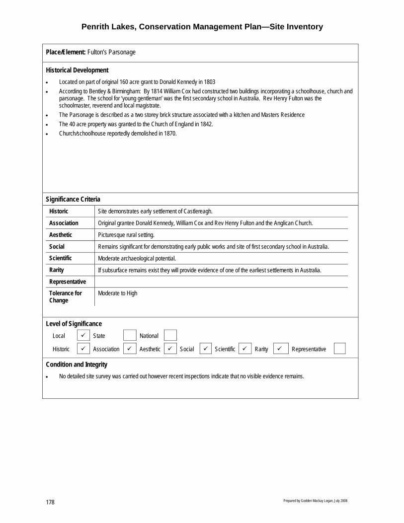
Penrith Lakes, Conservation Management Plan—Site Inventory
Prepared by Godden Mackay Logan, July 2008 178
Place/Element: Fulton’s Parsonage
Historical Development • Located on part of original 160 acre grant to Donald Kennedy in 1803 • According to Bentley & Birmingham: By 1814 William Cox had constructed two buildings incorporating a schoolhouse, church and
parsonage. The school for ‘young gentleman’ was the first secondary school in Australia. Rev Henry Fulton was the schoolmaster, reverend and local magistrate.
• The Parsonage is described as a two storey brick structure associated with a kitchen and Masters Residence • The 40 acre property was granted to the Church of England in 1842. • Church/schoolhouse reportedly demolished in 1870.
Significance Criteria
Historic Site demonstrates early settlement of Castlereagh.
Association Original grantee Donald Kennedy, William Cox and Rev Henry Fulton and the Anglican Church.
Aesthetic Picturesque rural setting.
Social Remains significant for demonstrating early public works and site of first secondary school in Australia.
Scientific Moderate archaeological potential.
Rarity If subsurface remains exist they will provide evidence of one of the earliest settlements in Australia.
Representative
Tolerance for Change
Moderate to High
Level of Significance
Local State National
Historic Association Aesthetic Social Scientific Rarity Representative
Condition and Integrity
• No detailed site survey was carried out however recent inspections indicate that no visible evidence remains.

Penrith Lakes, Conservation Management Plan—Site Inventory
Prepared by Godden Mackay Logan, July 2008 179
Place/Element: Fulton’s Parsonage
Policy Recommendations • Any archaeological relics belonging to Fulton’s Parsonage would be an important research resource. They should be left
undisturbed where possible. • Consider non-invasive and non-destructive methods of investigation to investigate the potential for geophysical survey (GPR,
magnetometry etc) to clarify the nature and extent of the potential archaeological resource in this zone. • If the relics are under threat (for example, from erosion or vandalism) it may be appropriate to archaeologically investigate the
relics in order to ensure that their research potential is met. In the first instance, efforts should be made to protect the relics without disturbing them.
• Upon excavation, every effort should be taken to retain and conserve exposed relics in situ. • The results of any archaeological investigation of the site (excavation or geophysical survey) should inform interpretation measures
designed to ‘tell the story’ of the site and area. • Maintain the allotment in a ‘bush’ state. However, it would also be appropriate for subtle landscaping, including ‘walking trails’, to
be introduced to facilitate interpretation of the history and archaeology of the area. • Avoid incremental destruction of the archaeological resource (for example, by regularly clearing the area of plants and trees with
deep roots). • Avoid plantings in the zone that may destroy the archaeological resource by root action. Prefer plantings that will stabilise the area
(for example, to prevent erosion) without deep root systems. • If there is an expectation that bush management work, fire control measures, etc will involve significant ground disturbance, data
from the archaeological resource is best obtained in a controlled open area excavation across the area.

Penrith Lakes, Conservation Management Plan—Site Inventory
Prepared by Godden Mackay Logan, July 2008 180
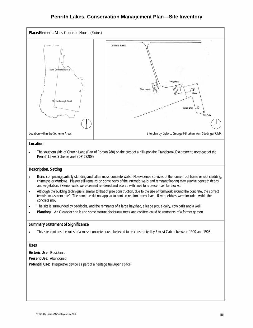
Penrith Lakes, Conservation Management Plan—Site Inventory
Prepared by Godden Mackay Logan, July 2010 181
Place/Element: Mass Concrete House (Ruins)
Location within the Scheme Area. Site plan by Gyford, George FB taken from Stedinger CMP.
Location
• The southern side of Church Lane (Part of Portion 280) on the crest of a hill upon the Cranebrook Escarpment, northeast of the Penrith Lakes Scheme area (DP 68289).
Description, Setting • Ruins comprising partially standing and fallen mass concrete walls. No evidence survives of the former roof frame or roof cladding,
chimneys or windows. Plaster still remains on some parts of the internals walls and remnant flooring may survive beneath debris and vegetation. Exterior walls were cement rendered and scored with lines to represent ashlar blocks.
• Although the building technique is similar to that of pise construction, due to the use of formwork around the concrete, the correct term is ‘mass concrete’. The concrete did not appear to contain reinforcement bars. River pebbles were included within the concrete mix.
• The site is surrounded by paddocks, and the remnants of a large hayshed, sileage pits, a dairy, cow bails and a well. • Plantings: An Oleander shrub and some mature deciduous trees and conifers could be remnants of a former garden.
Summary Statement of Significance • This site contains the ruins of a mass concrete house believed to be constructed by Ernest Caban between 1900 and 1903.
Uses Historic Use: Residence Present Use: Abandoned Potential Use: Interpretive device as part of a heritage trail/open space.

Penrith Lakes, Conservation Management Plan—Site Inventory
Prepared by Godden Mackay Logan, July 2010 182
Place/Element: Mass Concrete House (Ruins)
Historical Development • In 1878 Joseph Daniel Single, third son of John and Sarah Single of Nepean Park, purchased 38 acres. Joseph sold 25 acres to
Robert Wisdom in 1886. Neither owner resided on the property (likely to have been used for grazing). • Wisdom’s portion was sold to the Maybury’s following his death in 1890, who then sold the property to orchardist Ernest Caban in
1897. It is considered likely that the mass concrete house was constructed during Caban’s ownership in c1900 (although a broader date range has been suggested by Gyford of between 1892 and 1912)
• Caban sold the 25 acre property in 1903 to John McCabe, who sold it to Thomas Wilson in 1906. The property was then purchased by George McNickle in 1908 and Samuel Sherwood and Charles Grice in 1912.
• Sherwood and Grice lived on the property 1912–1915 by which time the house is likely to have been constructed. In 1915 Sherwood obtained full ownership of property, but sold it in 1932 to Andreas and Selma Holst, who ran a dairy and lived on the property.
• Property sold in 1941 to Claude Grant, who sold to Douglas Bloomfield. Shortly thereafter Walter and Ivy Martin purchased the property, later selling to Harry and Barbara Mortimer.
• In c1960 the property was sold to River Sand & Gravel Pty. By 1975 property appears to have been abandoned.
Significance Criteria Historic Demonstrates early settlement of the Castlereagh area.
Associated with early C20th phase of increased small land holdings in the Castlereagh area with the development of dairy farming.
Association Associated with Joseph Daniel Single, first owner and well known and respected local figure.
Aesthetic Located on a prominent elevated area, selected for its views.
Social
Scientific Demonstrates early construction materials and techniques Moderate archaeological potential.
Rarity Demonstrates unusual construction technique using mass concrete (one of only three examples in the area).
Representative
Tolerance for Change
High
Level of Significance Local State National
Historic Association Aesthetic Social Scientific Rarity Representative

Penrith Lakes, Conservation Management Plan—Site Inventory
Prepared by Godden Mackay Logan, July 2010 183
Place/Element: Mass Concrete House (Ruins)
Condition and Integrity
• Extremely deteriorated, dilapidated ruins overgrown with weeds and scrub. Beyond repair/ restoration. Located in the Cranebrook Escarpment CA. Owned by PLDC. No site inspection conducted.
Fabric Maintenance Requirements
Ruins Retain ruins in present state and manage as a standing ruin.
Archaeological remains Conserve and retain in situ.
Plantings Retain all significant traditional plantings. Implement weed management system.
Policy Recommendations: • Stabilise ruins and make safe. • Consider managing ruins as a standing ruin. • Prepare a HIS prior to undertaking any work in the area. • An archival recording should be undertaken prior to any works. • No historic fabric or traditional plantings to be removed from site unless indicated in CMP. Any fabric that is removed in
accordance with conservation and maintenance policies of the CMP should first be archivally recorded. • No excavation should occur without a permit under s140 of the Heritage Act. • The ruins should be interpreted. • Consider integrating the ruins into public open space. • Invasive weeds and scrub should be carefully removed so as not to disrupt the ruins or the archaeological resource. Where roots
of trees or shrubs are growing in cultural deposits or in joints between concrete blocks, cut the stems level with the feature and paint stem with poison.
• Important views should be retained, particularly those to other remaining homesteads or farms.
Ruins of mass concrete house. (Source: Penrith City Council)

Penrith Lakes, Conservation Management Plan—Site Inventory
Prepared by Godden Mackay Logan, July 2010 184

Penrith Lakes, Conservation Management Plan—Site Inventory
Prepared by Godden Mackay Logan, July 2010 185
Place/Element: Lee’s Cottage
Location within the Scheme Area. No image available
Location
• Southwest part pf the PL site (Part of Portion 71), approximately 20 m east of Old Castlereagh Road. Approx 40 m from the Methodist Church.
Description, Setting
• Site contains the ruins of cottage dating from c1840, formerly occupied by John Lee’s descendents, comprising concrete footings, concrete flooring, remnant brick walls, remnant fireplace/ oven, several mounds containing rubble, a well, and a corrugated iron water tank. The site is covered in dense scrub, mature weeds and light undergrowth. Some tree plantings are located around the site boundary.
• Although the precise location of the cottage is unknown this site is associated with the Upper Castlereagh Village Group, which is important as a related group forming the nucleus of a denominational community and village centre along Old Castlereagh Road.
• The immediate setting/curtilage includes Old Castlereagh Road and the Methodist Cemetery and Church. The church and cemetery are located to the south with the Parson’s accommodation, a function centre, amenities and offices located to the east. The broader setting includes the Blue Mountains to the west and Regatta Centre to the east (with a quarry haulage road running between the lake and the cemetery boundary).
• An early brick well is located north of the cemetery is located on this site. • Plantings include three large peppercorn trees located to the northwest and east. Eucalyptus trees are scattered towards the
western boundary and to the south (adjoining Methodist Church).
Summary Statement of Significance • Lee’s Cottage is located on a section of the original 90 acres granted to John Lees by Governor King in 1804. The site contains
the remains of a nineteenth century dwelling and forms part of Upper Castlereagh Village Group which includes the Methodist church and cemetery, adjacent school and schoolmasters residence.
Uses Historic Use: Residence Present Use: n/a Potential Use: Interpretive feature
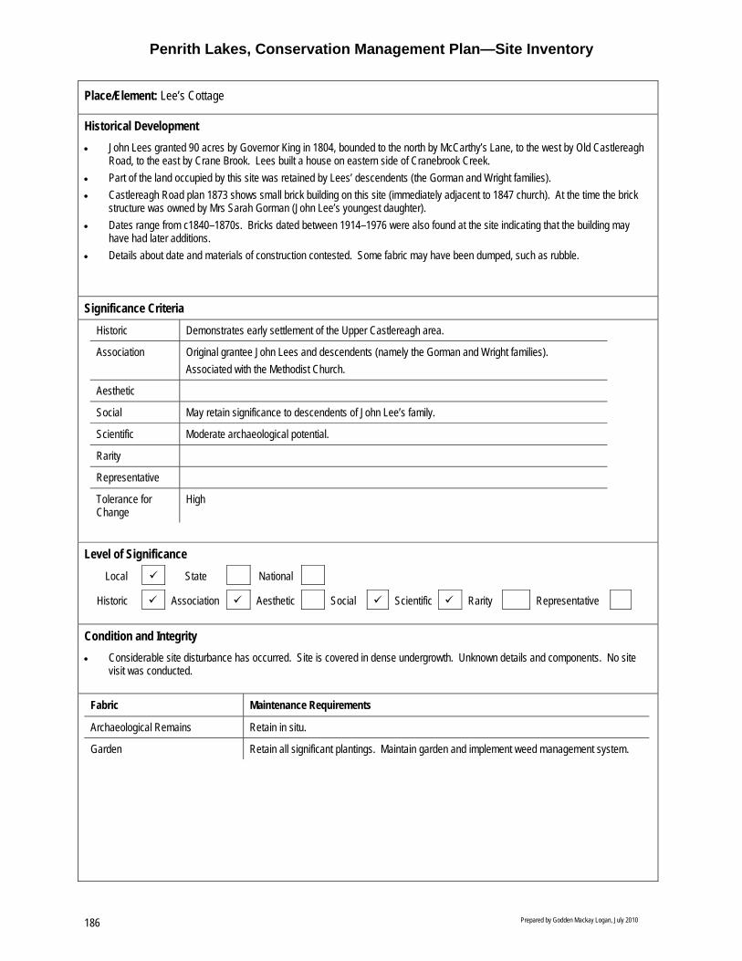
Penrith Lakes, Conservation Management Plan—Site Inventory
Prepared by Godden Mackay Logan, July 2010 186
Place/Element: Lee’s Cottage
Historical Development • John Lees granted 90 acres by Governor King in 1804, bounded to the north by McCarthy’s Lane, to the west by Old Castlereagh
Road, to the east by Crane Brook. Lees built a house on eastern side of Cranebrook Creek. • Part of the land occupied by this site was retained by Lees’ descendents (the Gorman and Wright families). • Castlereagh Road plan 1873 shows small brick building on this site (immediately adjacent to 1847 church). At the time the brick
structure was owned by Mrs Sarah Gorman (John Lee’s youngest daughter). • Dates range from c1840–1870s. Bricks dated between 1914–1976 were also found at the site indicating that the building may
have had later additions. • Details about date and materials of construction contested. Some fabric may have been dumped, such as rubble.
Significance Criteria Historic Demonstrates early settlement of the Upper Castlereagh area.
Association Original grantee John Lees and descendents (namely the Gorman and Wright families). Associated with the Methodist Church.
Aesthetic
Social May retain significance to descendents of John Lee’s family.
Scientific Moderate archaeological potential.
Rarity
Representative
Tolerance for Change
High
Level of Significance
Local State National
Historic Association Aesthetic Social Scientific Rarity Representative
Condition and Integrity • Considerable site disturbance has occurred. Site is covered in dense undergrowth. Unknown details and components. No site
visit was conducted.
Fabric Maintenance Requirements
Archaeological Remains Retain in situ.
Garden Retain all significant plantings. Maintain garden and implement weed management system.

Penrith Lakes, Conservation Management Plan—Site Inventory
Prepared by Godden Mackay Logan, July 2010 187
Place/Element: Lee’s Cottage
Policy Recommendations • Retain and conserve the site. • No historic fabric or traditional plantings to be removed from site. • Retain views to Methodist Group (south)—avoid dense plantings. • Any new structures on this site should require a Statement of Heritage Impact. • Further historic research and archaeological investigation involving minor excavation may be required for interpretation of the site
and to understand sequence of site occupation (subject to excavation permit application—section 140) • Historic relationship with the Methodist Group and School Group should be interpreted. • Invasive vegetation that is not significant should be removed and a weed management system implemented, ensuring that the
archaeological resource is undisturbed.

Penrith Lakes, Conservation Management Plan—Site Inventory
Prepared by Godden Mackay Logan, July 2010 188
Place/Element: Lee’s Cottage

Penrith Lakes Scheme—Conservation Management Plan, September 2010 189
8.0 Bibliography
Adamson, CL, “The Crushed Stone and Gravel Industry in the County of Cumberland, NSW”, in Contracting and Construction Equipment, December 1966.
Attenbrow, V, Sydney’s Aboriginal Past: Investigating the archaeological and historical record, UNSW Press, Sydney, 2002.
Birmingham Judy and Bently, Fran, Penrith Lakes Scheme Regional Environmental Study: History of European Settlement, 1981.
Britton Geoffrey and Morris Colleen, for the Penrith Lakes Development Corporation, Castlereagh Cultural Landscape Study, Assessment and Recommendations, July 1999.
Campbell, JF, ‘Early Settlement on the Lower Nepean River, New South Wales’, in the Journal of the Royal Australian Historical Society, V18 1932,
Comber Consulting, Aboriginal Archaeology and Cultural Heritage, Penrith Lakes Development Corporation, Castlereagh Concept prepared for Penrith Lakes Development Corporation, January 2007
Fox and Associates, Heritage Study of the City of Penrith, 1987.
Gyford George F B, A Report on Steadman’s Cottage—Castlereagh, Nepean District Historical Archaeology Group, February 1984.
Gyford George F B, A Report on Parker’s Slaughter Yard—Castlereagh, Nepean District Historical Archaeology Group, March 1994.
Gyford George F B and Turner Maureen, A Report on Purcell’s Cottage—Castlereagh, Nepean District Historical Archaeology Group , June 1994.
Gyford George F B , A Report on Site No 36 Barn and Dairy Castlereagh, Nepean District Historical Archaeology Group, 31 August 1994.
Gyford George F B, A Report on Wright’s Farm Complex—Castlereagh, Nepean District Historical Archaeology Group, July 1993.
Gyford George F B, A Report on Vella’s Farm at Wright’s Farm Complex—Castlereagh, Nepean District Historical Archaeology Group, August 1993.
Gyford George F B, A Report on Site No. 26—Weatherboard Cottage William Wright’s Farm—Castlereagh, Nepean District Historical Archaeology Group, November 1993.
Gyford George F B, A Report on Strathcairns Cottage—Cranebrook, Nepean District Historical Archaeology Group, October 1994.
Gyford George F B, A Report on McCarthy Farm—Cranebrook, Nepean District Historical Archaeology Group, 1995.
Gyford George F B, A Report on Church Lane—Castlereagh, Nepean District Historical Archaeology Group, June 1996.

Penrith Lakes Scheme—Conservation Management Plan, September 2010 190
Gyford George F B, A Report on The Pise House—Castlereagh, Nepean District Historical Archaeology Group, July 1996.
Gyford George F B, A Report on Farrells Lane—Castlereagh, Nepean District Historical Archaeology Group, April 1999.
Gyford George F B, A Report on Site 28, Bungalow, Castlereagh Road, Castlereagh, Nepean District Historical Archaeology Group, July 1999.
Gyford George F B, A Report on Site 14, Weatherboard Cottage, Castlereagh Road, Castlereagh, Nepean District Historical Archaeology Group, June 2000.
Gyford George F B, A Report on Site 7 Cottage and Outbuildings, Castlereagh Road, Castlereagh, Nepean District Historical Archaeology Group, June 2000.
Gyford George F B, A Report on Site 22 Federation Cottage, Castlereagh Road, Nepean District Historical Archaeology Group, June 2000.
Gyford George F B, A Report on Site 25 Federation Cottage, Castlereagh road, Castlereagh, Nepean District Historical Archaeology Group, June 2000.
Gyford George F B and Wright Ros, A Report on the Mass Concrete House at Castlereagh, 43 Smith Street, Nepean District Historical Archaeology Group, August 2002.
Gyford George F B A Report on Site 23, Parkers Homestead, Castlereagh Road, Castlereagh, Nepean District Historical Archaeology Group, September 2002.
Gyford George F B A Report on Site 3, Vine Cottage Complex—Castlereagh, Nepean District Historical Archaeology Group, March 2004.
Gyford George F B A Report on Site 15, ‘Minnaville’ Castlereagh Road, Castlereagh, Nepean District Historical Archaeology Group, March 2004.
Hamilton Mary Ann and Andersen Sue, Penrith Lakes Scheme Oral History Study for Penrith Lakes Development Corporation, Compiled by OHM Consultants, December 1998.
Karskens Grace, Urban People, Urban Places, Urban Resilience: A paper in honour of Pat Troy, Delivered at Vulnerability on Australian Cities: Towards Sustainability and Security: a public Symposium, Brisbane 5 May 2006
Karskens Grace, Water Dreams, Earthern Histories: Exploring Urban Environmental History at Penrith Lakes Scheme and Castlereagh, Sydney, Environment and History 13, The White Horse Press, 2007
Liston Carol, Research Towards the History of Castlereagh to 1806, (no date).
Nepean District Archaeological Group, In Search of the Early Nepean Pioneers, A Post Settlement History Celebrating the Bi-centenary of the 1803 Land Grants, 2003.
Proudfoot Helen, Exploring Sydney’s West, Kangaroo Press, Sydney, 1987.
Stearns Kinhill, for the Department of Environment and Planning, Regional Environmental Study (RES), 1984.
Stedinger Associates, BMI Plant, Archival Recording, Stage I, May 2005.

Penrith Lakes Scheme—Conservation Management Plan, September 2010 191
Stedinger Associates, BMI Plant, Archival Recording, Stage II, November 2006
Stedinger Associates, Excavation of Castlereagh Road and Parkers Well in the Penrith Lakes Scheme Area, An Archaeological Assessment and Excavation Permit Application, October 2006
Stedinger Associates, European Heritage within the Penrith Lakes Scheme, A Conservation Management Plan (Master Plan), December 2006.
Stedinger Associates, Revised Concept Plan for the Penrith Lakes Scheme. A Statement of Heritage Impact - European Heritage, January 2007.
Stedinger Associates, Mass Concrete House at 43 Smith Road Castlereagh, A Conservation Management Plan and Schedule of Works, March 2007.
Stedinger Associates, Hadley Park: A Conservation Management Plan and Schedule of Works, July 2007.
Stedinger Associates, McCarthy’s Cemetery, Draft Conservation Management Plan, February 2008.
Tench, W, A Complete Account of the Settlement at Port Jackson Tim Flannery (ed), The Text Publishing Company, Melbourne, 1996.
Total Catchment Management Services Pty Ltd, Castlereagh Biodiversity and Natural Heritage Conservation Master Plan, Draft Interim Report, July 2007.

Penrith Lakes Scheme—Conservation Management Plan, September 2010 192

Penrith Lakes Scheme—Conservation Management Plan, September 2010 193
9.0 Appendices
Appendix A Sydney Regional Environmental Plan No.11 (Penrith Lakes), Approved Penrith Lakes Structure Plan, 1998.
Appendix B State Heritage Register (SHR) citation for the Upper Castlereagh School and Residence.
Appendix C National Trust Listing Cards for Sites within the Scheme Area.
Appendix D Register of the National Estate (RNE) citations for Sites within the Scheme Area.

Penrith Lakes Scheme—Conservation Management Plan, September 2010 194

Appendix A Sydney Regional Environmental Plan No.11 (Penrith Lakes), Approved Penrith Lakes Structure Plan, 1998.

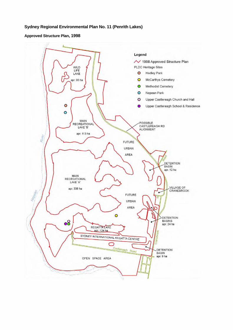
Sydney Regional Environmental Plan No. 11 (Penrith Lakes)
Approved Structure Plan, 1998


Appendix B State Heritage Register (SHR) citation for the Upper Castlereagh School and Residence.

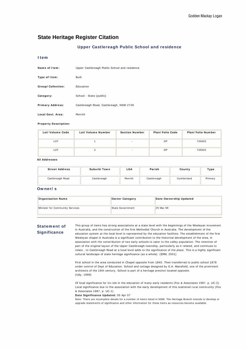
State Heritage Register Citation Upper Castlereagh Public School and residence
Item
Name of Item: Upper Castlereagh Public School and residence
Type of Item: Built
Group/Collection: Education
Category: School - State (public)
Primary Address: Castlereagh Road, Castlereagh, NSW 2749
Local Govt. Area: Penrith
Property Description:
Lot/Volume Code Lot/Volume Number Section Number Plan/Folio Code Plan/Folio Number
LOT 1 - DP 735602
LOT 2 - DP 735602
All Addresses
Street Address Suburb/Town LGA Parish County Type
Castlereagh Road Castlereagh Penrith Castlereagh Cumberland Primary
Owner/s
Organisation Name Owner Category Date Ownership Updated
Minister for Community Services State Government 25 Mar 99
Statement of
Significance
This group of items has strong associations at a state level with the beginnings of the Wesleyan movement
in Australia, and the construction of the first Methodist Church in Australia. The development of the
education system at the local level is represented by the education facilities. The establishment of the first
Wesleyan chapel in Australia is a significant contribution to the historical development of the area, in
association with the constribution of two early schools to cater to the valley population. The retention of
part of the original layout of the Upper Castlereagh township, particularly as it related, and continues to
relate , to Castlereagh Road at a local level adds to the significance of the place. This is a highly significant
cultural landscape of state heritage significance (as a whole). (ERM, 2001)
First school in the area conducted in Chapel opposite from 1840. Then transferred to public school 1878
under control of Dept of Education. School and cottage designed by G.A. Mansfield, one of the prominent
architects of the 19th century. School is part of a heritage precinct located opposite.
(Udy, 1999)
Of local significance for its role in the education of many early residents (Fox & Associates 1987, p. UC-2).
Local significance due to the association with the early development of this scattered rural community (Fox
& Associates 1987, p. UC-1).
Date Significance Updated: 05 Apr 07 Note: There are incomplete details for a number of items listed in NSW. The Heritage Branch intends to develop or
upgrade statements of significance and other information for these items as resources become available.
Description
Designer: GA Mansfield
Builder: James Evans
Construction Years: 1878 - 1879
Physical Description: School: A simple rectangular hall with attached side entry porch typical of rural public schools of the
period. Gothic revival in form and detailing the building features steeply pitched gables with timber barge
boards, braces and finials, together with simply stepped buttresses to the porch walls and Tudor arched
entrance. Major finishes include face brickwork to walls, stone basecourse, sills and buttress dressings and
contrasting rubbed brick heads to windows and entrance porch. The roof is corrugated iron sheeting.
Windows are boarded over, the main entry door is timber, framed and sheeted. Out buildings associated
with the main school building included the original brick privy.
Schoolmaster's Residence: A simple Victorian painted brick cottage with hipped corrugated iron roofs to
main structure and front verandah. Extant original windows are 2x6 pane double hung sashes. Chimneys to
main residence and service wing feature simple corbelled brickwork tops and strings.
(Udy, 1999)
Physical Condition
and/or
Archaeological
Potential:
The physical condition of the school and residence is poor with problems such as rusting or roof iron,
gutters and downpipes and deterioration of exposed timber elements and painted finishes. (Udy, 1999)
Date Condition Updated: 23 Jul 02
Modifications and Dates: Boarded timber lean to added to school (south elevation) plus additional slated timber lean to at rear of
house. Unsympathetic additions and original details in evidence.
Further Information: The significance of the sites as representative of important early personages and social patterns in the
Castlereagh area should be retained. This historical/social, cultural significance is, in large measure,
associated with the site through verbal transfer of information and the evidence of documentary sources.
Physical elements that represents aspects of this significance include site boundary demarcation elements
(early fences and tree planting). Opposite the site are elements erected for a special social purpose of
importance to the area as a whole (eg the original weatherboard school and its later replacement, the
church, Castlereagh Road etc). The continuing use of a site for functions is a means of preserving its
historical significance.
(Udy, 1999)
Current Use: School - damaged and locked up; House - Learning Centre for Disadvantaged (1999)
Former Use: School - opened 1879, closed during the 1970s
History
Historical Notes: The land on which the school building is sited was originally part of Portion 54, granted to Edward Field in
1803 (100 acres).
This block was donated by the family for the purpose of building the school. (Penrith Lakes Scheme -
Regional Environmental Study - History of European Settlement 1983 (pp 43-44))
The school symbolises the basic decision of the State to provide public education for all children as distinct
from Church connected education. School in the church hall opposite ceased forthwith and for just under
100 years this single room school was the centre of basic education for children at Upper Castlereagh.
(Udy, 1999)
Historic Themes
Australian Theme
(abbrev) New South Wales Theme Local Theme
6. Educating - Educating Education - Activities associated with teaching and learning by children and adults,
formally and informally.
Public (primary)
schooling -

Assessment of Significance
SHR Criteria a)
[Historical Significance]
The school is a visible reminder of the decision to establish public schools in the nineteenth century. It is a
sample of Mansfield's work at the same time he was planning Prince Alfred Hospital. Together with the
Chapel, Hall and Cemetery, the School forms an historic heritage precinct.
(Udy, 1999)
SHR Criteria c)
[Aesthetic Significance]
Constructed of brick with a steep corrugated iron gabled roof, the school room and brick residence are
features of the development of this rural community. They form a part of the early Church/School precinct
at Upper Castlereagh. The sites are aesthetically pleasing and harmonious in their immediate physical
settings and for the aesthetic character of individual grouped elements viewed from within the sites.
(Udy, 1999)
SHR Criteria d)
[Social Significance]
In conjunction with the 19th century Chapel, Hall and Cemetery opposite, this is now classed as a "heritage
precinct".
As a contemporary community by using residential Academy opposite for educational purposes: spiritual
purposes and social purposes there will be a continuous flow of people.
(Udy, 1999)
SHR Criteria e)
[Research Potential]
Taking stages of growth in Australian history could be the subject of on site residential classes of school
children examining the story or European settlement and Aborigines: new settler phase (1806 - 1867),
small holdings and subdivision (1867 - 1950), present phase (1950 - 2000) travel and recreation.
(Udy, 1999)
SHR Criteria f)
[Rarity]
(a) Historical - Church and State division symbolised by two separate buildings.
(b) Cultural - Symbol of interrelationship of school, Chapel and Cemetery 125 years ago.
(Udy, 1999)
SHR Criteria g)
[Representitivenes]
(a) Life in the "interior" of a convict colony
(b) Grants to ticket of leave - for convict settlers along River
(c) Opposite site connects first gift to Australian Methodists by ex Rum Corps Soldier 18
(d) 50% Convicts and Ticket-of-Leave persons associated with present Chapel (1847)
(Udy, 1999)
Integrity/Intactness: (a) Restored school to be used for community seminars - by school children and adults
(b) Residence to be used by caretaker/guide for the heritage precinct on both sides of Castlereagh Road
(Udy, 1999)
Assessment Criteria Items are assessed against the State Heritage Register (SHR) Criteria to determine the level of significance.
Refer to the Listings below for the level of statutory protection.
Procedures /Exemptions
Section of
Act Description Title Comments
Action
Date
57(2) Exemption to
allow work
Standard
Exemptions
SCHEDULE OF STANDARD EXEMPTIONS
HERITAGE ACT, 1977
Order Under Section 57(2) of the Heritage Act, 1977
I, the Minister for Planning, pursuant to section 57(2) of the Heritage Act 1977,
on the recommendation of the Heritage Council of New South Wales, do by this
Order:
1. revoke the Schedule of Exemptions to subsection 57(1) of the Heritage Act
made under subsection 57(2) and published in the Government
Gazette on 7 March 2003, 18 June 2004 and 8 July 2005; and
2. grant standard exemptions from section 57(1) of the Heritage Act 1977,
described in the Schedule below.
FRANK SARTOR
Minister for Planning
Sydney, 25 March 2006
To view the schedule click on the Standard Exemptions for Works Requiring
Heritage Council Approval link below.
Mar 25
2006

Listings
Heritage Listing Listing Title Listing
Number
Gazette
Date
Gazette
Number
Gazette
Page
Heritage Act - State Heritage Register 00339 02 Apr 99 27 1546
Heritage Act - Permanent Conservation
Order - former
00339 18 Jan 85 19
Heritage Act - s.170 NSW State agency
heritage register
Regional Environmental Plan 21 Oct 97
Regional Environmental Plan REP 11 Penrith Lakes Scheme 25 Nov 94
Heritage study Uniting Church Group Upper
Castlereagh
UC 3 04 Jan 87
National Trust of Australia register 8597, 8598
References, Internet links & Images
Type Author Year Title Internet
Links
Tourism Attraction Homepage 2007 Penrith Valley Heritage Drive Click here
Tourism 2007 Penrith Valley Heritage Drive Click here
Written Environmental Resources Management (ERM) 2001 Penrith Lakes Scheme Cultural Heritage Management Study
Written Morris, C. & Britton, G. 1999 Castlereagh Cultural Landscape Study
Written
Note: Internet links may be to web pages, documents or images.
Data Source
The information for this entry comes from the following source:
Name: Heritage Office
Database Number: 5000920
File Number: S90/04859
Every effort has been made to ensure that information contained in the State Heritage Inventory is correct. If you find any errors or omissions please send your comments to the Database Manager. All information and pictures on this page are the copyright of the Heritage Branch or respective copyright owners.
http://www.heritage.nsw.gov.au/07_subnav_01_2.cfm?itemid=5000920

Appendix C National Trust Listing Cards for the following sites within the Scheme Area:
• Nepean Park
• Hadley Park
• McCarthys Cemetery and
• Methodist Church, Hall and Cemetery


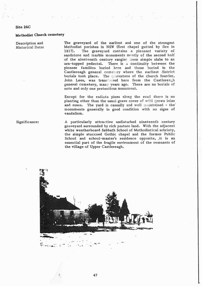
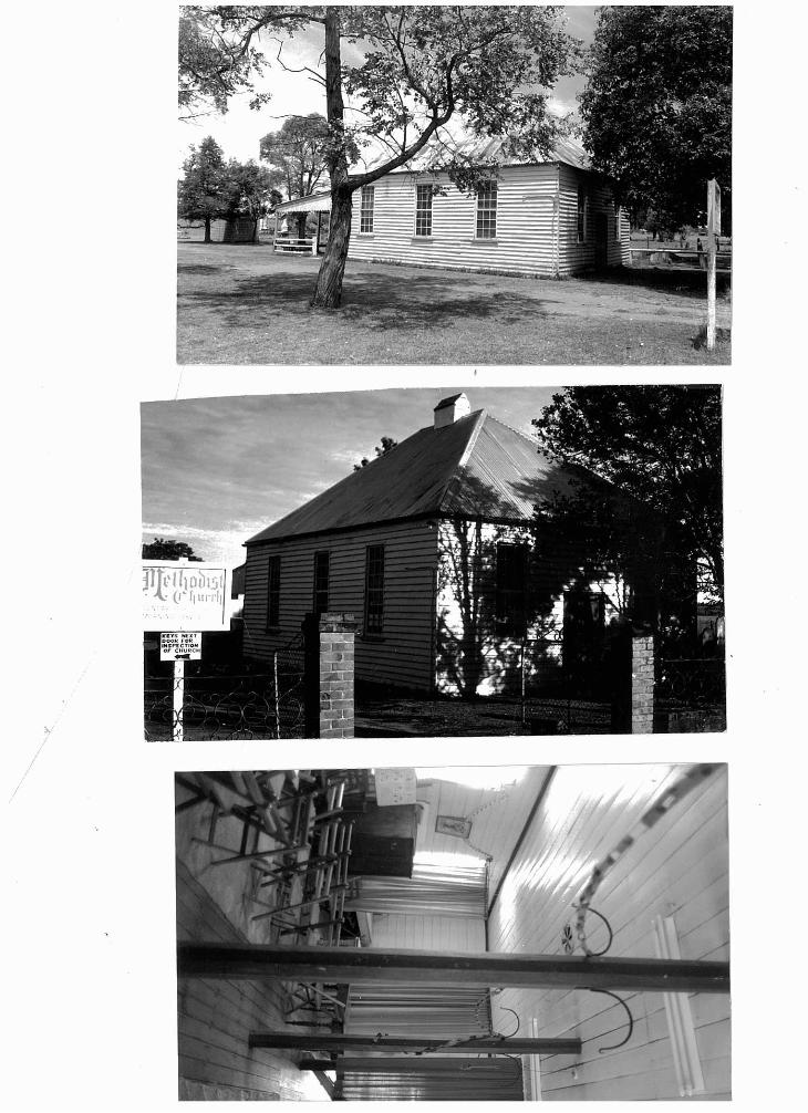


Appendix D Register of the National Estate (RNE) citations for the following sites, elements and areas within the Scheme Area:
• Castlereagh Area, of which part is within the Scheme Area.
• Nepean Park.
• Upper Castlereagh Room Chapel, Hall and Cemetery.


Australian Heritage Database
Place Details–Castlereagh Area, Upper Castlereagh, NSW
Photographs: None
List: Register of the National Estate
Class: Historic
Legal Status: Indicative Place
Place ID: 101338
Place File No: 1/14/029/0031
Nominator's Statement of Significance:
Castlereagh was the earliest official settlement the Nepean River. Settlers were present from the early 1790s. Produce from Castlereagh ensured the survival of the Sydney colony. Governor King made land grants to settlers, mainly from the military, in 1803. Castlereagh Road, surveyed by James Meehan at this time, is one of the oldest in Australia and still follows its original alignment. It was the only road into the Evan District until the building of the Western Road (now Great Western Highway). Castlereagh was the site of many early confrontations between Aboriginals and Europeans. Aboriginal artifacts dating back 90,000 years have been found in the Castlereagh gravel beds. Governor Macquarie visited in 1810 and established Castlereagh as one of his five towns, the others being Wilberforce, Pitt Town, Windsor and Richmond. He planned Castlereagh on the ridge (Church Lane) away from the flood plain. He included a church, cemetery and school. It is the only Macquarie town to fail as it was too far away from the water supply with settlers staying on the flood plain. Castlereagh has changed little since early settlement. Many early buildings, as well as original land grants remain. Castlereagh has been described as the last remaining remnant of early settlement on the Cumberland Plain. It is unique in that building styles from more than 200 years of European settlement have survives. It is of national importance as a site of early colonization. Buildings range from Colonial times to present day. Churches, schools, pioneer cemeteries, trees and fences also remain. Several lanes named after early settlers survive, as well as Jackson's Mill, the only know remaining mill site on the Nepean River.
Official Values: Not Available
Description:
Castlereagh is situated on the floodplain of the Nepean River in the Penrith area and was one of the earliest established areas in the colony of New South Wales. Castlereagh Road, which runs the length of Castlereagh on a north/south axis is one of the earliest roads in Australia, possibly being the third oldest. Castlereagh is distinctive for the number of houses built before 1810 still surviving in the area. The area is predominantly a farming area and supplies much of the Sydney markets vegetable produce.
History: Not Available

Condition and Integrity: Not Available
Location:
About 300ha, bounded by the Nepean River, Private access road - 250m north of Castlereagh Equestrian Centre, Castlereagh Road, and the western boundary of Portion 301Parish of Castlereagh, Upper Castlereagh.
Bibliography: Not Available
Report Produced: Tue May 13 14:51:20 2008
http://www.environment.gov.au/cgi-bin/ahdb/search.pl

Australian Heritage Database
Place Details–Nepean Park, Castlereagh Rd, Castlereagh, NSW
Photographs: None
List: Register of the National Estate
Class: Historic
Legal Status: Registered (21/03/1978)
Place ID: 3118
Place File No: 1/14/029/0011
Statement of Significance:
Excellent example of an early two storey Georgian farmhouse substantially unaltered and which has retained its rural setting. The house and property form an important link with the early settlement of the historic Nepean district. (The Commission is in the process of developing and/or upgrading official statements for places listed prior to 1991. The above data was mainly provided by the nominator and has not yet been revised by the Commission.)
Official Values: Not Available
Description:
Two storey Georgian farmhouse of rendered sandstock brick, six panelled front door with sidelights and arched fanlight, stone flagged front verandah, cellars. Balcony has been removed, back verandah enclosed and additions made to one side. Interior has six panel doors and panelled jambs. Built about 1822 by convicts assigned to the owner John Single.
History: Not Available
Condition and Integrity: Not Available
Location:
Castlereagh Road, Castlereagh.
Bibliography:
Listing complied by F.Palmer of the Nepean Historical Society.
Report Produced: Wed Apr 9 19:12:34 2008
http://www.environment.gov.au/cgi-bin/ahdb/search.pl

Australian Heritage Database
Place Details–Upper Room Chapel, Hall and Cemetery, 1727 Castlereagh Rd, Castlereagh, NSW
Photographs: None
List: Register of the National Estate
Class: Historic
Legal Status: Indicative Place
Place ID: 103815
Place File No: 1/14/029/0035
Statement of Significance: Not Available
Official Values: Not Available
Description:
Church - Wesleyan Chapel, 3rd built on sacred acre. The church building is a simple rendered masonry structure, with Ecclesiastical Gothic embellishments added to the basic rectangular box form. These embellishments include simple gables (to east and west elevations) topped with thin coping stones, gothic style timber framed windows (to north and south facades) and a crenellated entry porch; gothic arch headed blank windows also feature on the south porch wall and church front. The interior of the church is of similar simplicity, an unornamented rectangular box except for wall mounted memorials and the delicate tracery of the multipaned sash windows. The major feature of the interior is undoubtedly its collection of original box pews. An ornamentally carved central pulpit and communion rail and a fretworked harmonium complete the inventory of major furniture items. Church Hall- The church hall is a simple late Georgian/ early Victorian timber framed and weatherboard clad structure featuring 2x9 pane pivoted sash windows to each of its major facades. On top of the main ridge of the simply hipped roof (currently sheeted with corrugated iron) is a small corrugated iron clad bell enclosure. To the rear (east) of the hall is a lean-to verandah supported on timber posts and finished with a boarded valence to its northern end. The southern end of the verandah has recently been enclosed to provide a small kitchen. The framed and sheeted pair of entry doors to the front (west) elevation is a modern reproduction of the original. The interior walls and ceiling of the hall are lined with the original wide beaded boards finished with a simple timber cornice. Octagonal timber posts along the centre of the hall support the roof framing over; these posts feature early wrought iron brackets used originally to hang lamps from. A rope for the roof mounted bell protrudes through the ceiling. Cemetery- The cemetery attached to the church is a well preserved example of a nineteenth century rural parish cemetery. The memorials range from simple headstones (from both 19th and 20th centuries) to an elaborate urn topped pedestal. The simpler headstones are generally located in groups
dispersed loosely over the site. Several graves also feature enclosing iron pallsade fences of varying elaborateness. Historically, the most significant of the gravestones is that of John Lees, the church's founder, which was (as noted above) transferred fron the Castlereagh general cemetery some years ago, in 1921.
History: Not Available
Condition and Integrity:
Significant fabric conserved and heritage painting of chapel and hall completed under supervision of heritage architect. Cemetery re-fenced as far as possible. Theft of heritage furniture from chapel and hall has occured and vandalisation of cemetery has taken place.
Location:
1727 Castlereagh Road, Castlereagh.
Bibliography:
Colless S MA Thesis Sydney University 1984 "Birds Eye Corner" 1789-1809. Kavanagh M, John Lees Chapel Builder 1987 Sutherland Stachan A Incidents in the Life of Samuel Leigh 1853 London Calwell J Illustrated History of Methodism 1904 Sydney Roberts SC John Lees:Story of Remarkable Life 1921 Penrith Crowley F A New History of Australia 1974 Melbourne Heenamon Jack I Methodist Chapels at Castlereagh 1999 Sydney University paper Udy GS "Spark of Grace" 1977 Surrey Beatty & Sons Chipping Norton Penrith Lakes Scheme: D/A Application #2 Items of Enviromental Heritage
Report Produced: Wed Apr 9 19:15:14 2008
http://www.environment.gov.au/cgi-bin/ahdb/search.pl