
PENNSYLVANIA DEPARTMENT OF TRANSPORTATION ENGINEERING ...
68
PENNSYLVANIA DEPARTMENT OF TRANSPORTATION ENGINEERING DISTRICT 3-0 LYCOMING COUNTY S.R.15, SECTION C41 FINAL HYDROLOGIC AND HYDRAULIC REPORT STEAM VALLEY RUN STREAM RELOCATION DATE: June, 2006 REVISED: August, 2006 PREPARED BY: DAWOOD ENGINEERING, INC 2020 GOOD HOPE ROAD ENOLA, PA 17025
Transcript of PENNSYLVANIA DEPARTMENT OF TRANSPORTATION ENGINEERING ...

PENNSYLVANIA DEPARTMENT OF TRANSPORTATION
ENGINEERING DISTRICT 3-0
LYCOMING COUNTY S.R.15, SECTION C41
FINAL HYDROLOGIC AND HYDRAULIC REPORT
STEAM VALLEY RUN STREAM RELOCATION
DATE: June, 2006 REVISED: August, 2006
PREPARED BY: DAWOOD ENGINEERING, INC
2020 GOOD HOPE ROAD ENOLA, PA 17025

State Route 15, Section C41 Stream Realignment
XIV.
PENNSYLVANIA DEPARTMENT OF TRANSPORTATION
STREAM REALIGNMENT
S.R. 15, SECTION C41
LYCOMING COUNTY, PENNSYLVANIA
A. INTRODUCTION
PENNDOT plans to realign three sections of Steam Valley Run between SR 15 SB
stations 149+00 to 173+00. The realignment is needed due to the fill slopes from the proposed roadway construction encroaching into the existing stream.
The purpose of Section XIV is to analyze the effects of the stream relocation on the water
surface elevations of Steam Valley Run. The drainage area upstream of the proposed culvert was determined to be 3.98 mi2.
In accordance with the Pennsylvania Department of Transportation’s Design Manual Part
2 (DM2) and SOL 431-99-11 the method of determining the flood discharges (peak rates of runoff) for a watershed of this size without a FEMA “Flood Insurance Study” or a gauge station record is to use the DM-2 “Method for estimating peak rates of runoff for drainage areas between 1.5mi2 and 150 mi2”. The water surface elevations for the various storm events for both the existing and proposed conditions were determined using the U.S. Army Corps of Engineers’ HEC-RAS Version 3.1.3 Surface Water Profile Program.
The project is the relocation of approximately 1600’ of Steam Valley Run. Therefore, the
project is water dependent and requires permitting. The data in this report is provided to obtain the necessary approvals for the proposed stream relocation. Line, Grade, and Typical Section approval was granted by District 3-0 on December 1, 2004.
B. PROJECT LOCATION
The proposed stream relocation is in Steam Valley Run in Cogan House Township,
Lycoming County, Pennsylvania (refer to location map for project location) and is in three sections from approximate SR 15 SB Sta 149+00 to approximate Sta 173+00 (refer to Stream Relocation Plan in Appendix N for plan view and Stream Cross Sections). Steam Valley Run runs in a northwest to southeast direction along the existing S.R. 15 Southbound alignment. Steam Valley Run drains 3.98 square miles of forest land (see Appendix N). The nearest existing upstream structure crossing Steam Valley Run is a 10.5’X12’ Corrugated Metal Pipe approximately 6800’ upstream. The nearest existing structure downstream of the stream

State Route 15, Section C41 Stream Realignment
State Route 15, Section C41 Stream Realignment
relocation is the bridge carrying SR 15 NB which is approximately 12,000 feet downstream. The stream is bound on both sides by steep forested hillsides along both of its banks for its entire length. The hillsides extend up to S.R. 15 Northbound on the east, and S.R. 15 Southbound on the west. Steam Valley Run parallels S.R. 15 Northbound and Southbound for much of its length. The detailed study area of this report includes the existing stream channel and proposed relocated alignment and overbank areas of Steam Valley Run extending for approximately 2900 feet. Refer to Appendix N for photographs taken at the project location.
C. EXISTING STRUCTURE
There are no existing structures crossing Steam Valley Run in this area.
D. CHANNEL AND BANK CONDITIONS
Steam Valley Run, in the area of the relocation, has a well defined channel with a bed
consisting of cobbles and small to medium sized boulders and areas of exposed bedrock. The immediate channel banks are covered with trees and brush and appear stable. The eastern and western overbank areas consist of steep forested roadway embankment continuing up to S.R. 15. The existing alignment of S.R. 15 runs parallel to the channel. The stream alignment is relatively straight and flows between S.R 15 Northbound and Southbound along its course.
The profile of the stream is moderate with an average slope of approximately 2.70%
throughout the entire upstream and downstream reach. E. HYDROLOGIC ANALYSIS
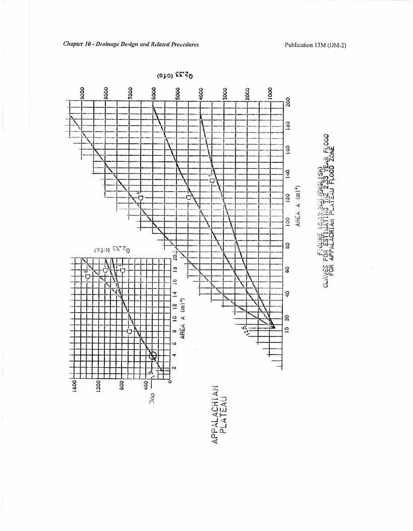
In accordance with the Pennsylvania Department of Transportation’s Design Manual Part 2 (DM2) and SOL 431-99-11 the method of determining the flood discharges (peak rates of runoff) for a watershed of this size without a FEMA “Flood Insurance Study” or a gauge station record is to use the DM-2 “Method for estimating peak rates of runoff for drainage areas between 1.5mi2 and 150 mi2”. The drainage area of Steam Valley Run upstream of the stream relocation was determined to be 3.98 mi2. The drainage area was determined to be in Zone “a” from Figure 10.12.1. The Risk Factor was determine to be negligible and was therefore 0. The Urbanization Factor was 0 due to less than 7% of the drainage area being urbanized. The Wood Factor was 0 due to the drainage area being less than 5 mi2 and the wooded area being greater than 40 %.

State Route 15, Section C41 Stream Realignment
The limestone Factor was 0 because there is no evidence of limestone in the area. These values were used to compute the peak discharges for various return periods in the watershed. Refer to Appendix N for hydrology backup information.
Peak Discharges
300 cfs for a 2.33-year storm event 540 cfs for a 10-year storm event 690 cfs for a 25-year storm event 810 cfs for a 50-year storm event 930 cfs for a 100-year storm event
These values will be used for the analysis of the stream relocation construction.
F. FISH LIFE AND WATER CONDITIONS
Steam Valley Run and its tributaries are not listed in Pennsylvania Code, Title 25, Part I, Subpart C, Article II, Chapter 93. However, Trout Run as a tributary to Lycoming Creek is listed as a High Quality Cold Water Fishery (HQ-CWF). Therefore, Steam Valley Run and its tributaries, being a tributary to Trout Run, are also considered High Quality Cold Water Fisheries. The PA Fish and Boat Commission does not list Steam Valley Run or its tributaries as Approved Trout Waters, a Wilderness Trout Stream, or Class A Wild Trout waters, but Steam Valley Run is listed as having a “Verified Trout Reproduction.” G. EXISTING CONDITION HYDRAULIC ANALYSIS
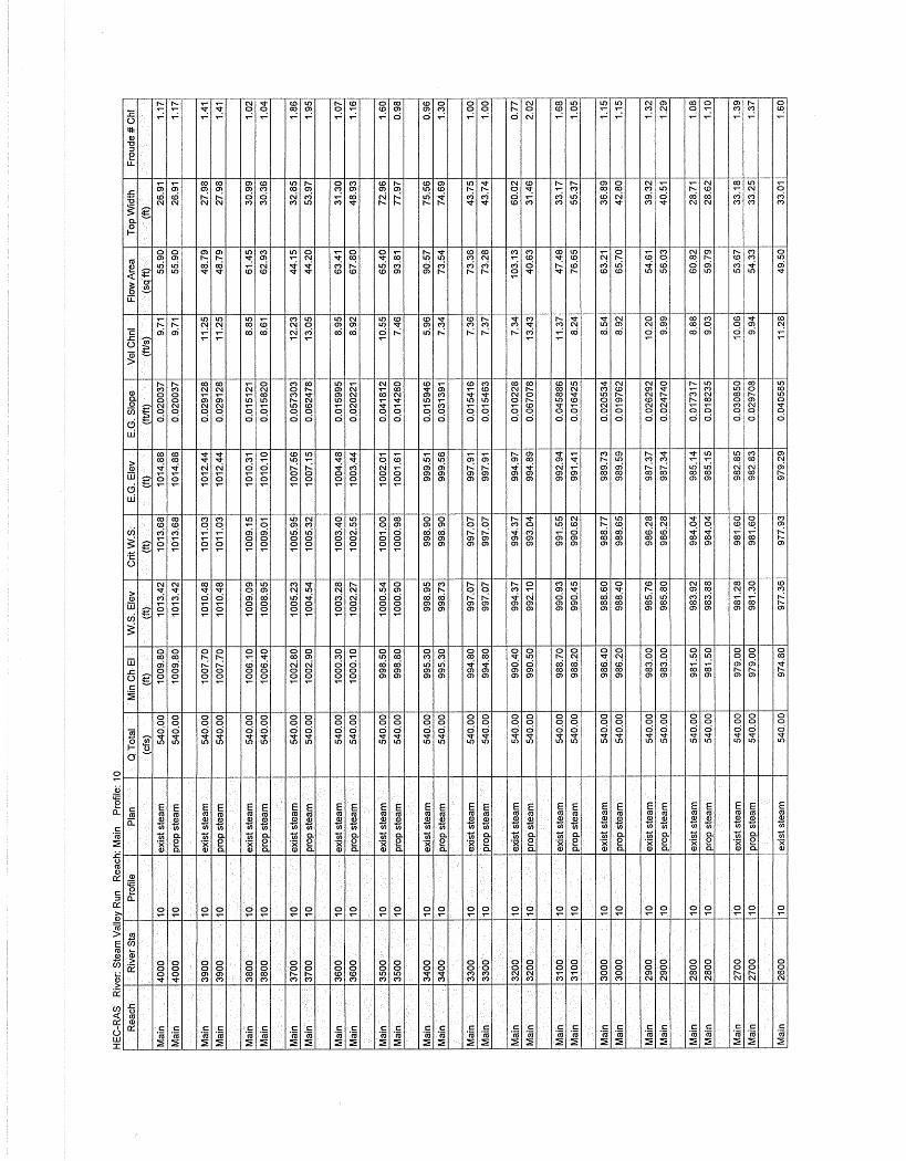
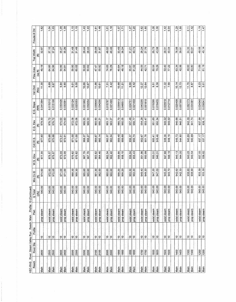
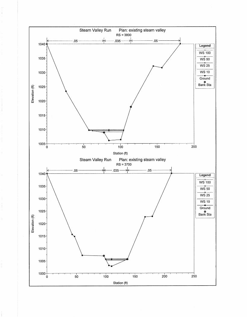
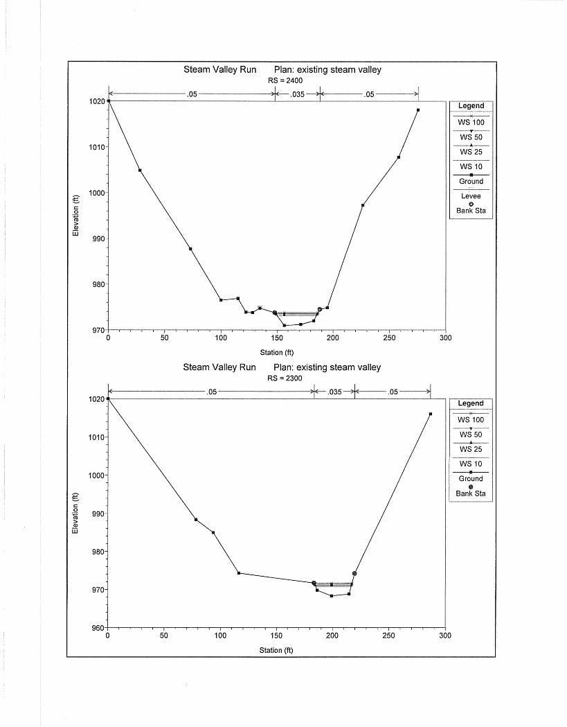
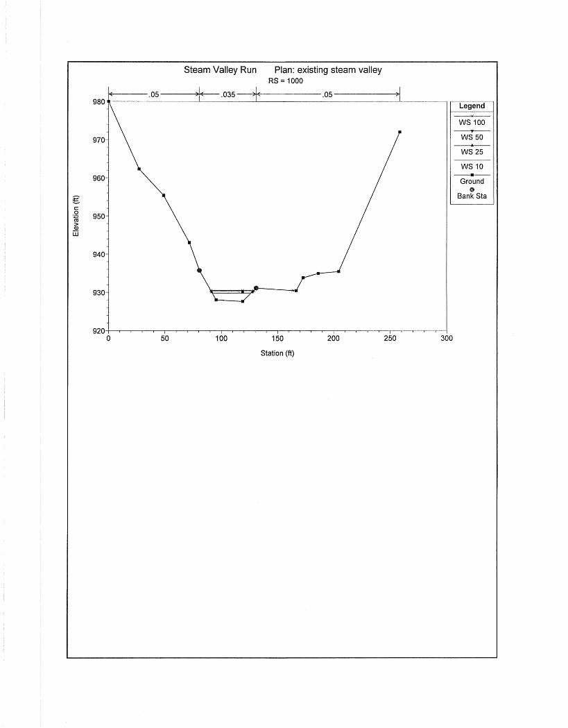
Flow depths and water velocities of the existing condition were determined using the HEC-RAS Computer Program. Design information and cross sections used for this study were taken from a field survey and is based on an assumed datum. Thirty existing stream cross sections were input into the HEC-RAS program (River Stations 4000-1000, see cross section location map) using a Manning’s “n” value of 0.035 for the stream and 0.05 for the overbank areas. The 10, 25, 50 and 100 year storms were analyzed for the existing condition. Refer to
Appendix N for existing hydraulic information.
H. PROPOSED CONDITION HYDRAULIC ANALYSIS

State Route 15, Section C41 Stream Realignment
Flow depths and water velocities for the proposed condition were determined using the
HEC-RAS Computer Program. Design information and cross sections used for this study were taken from a field survey and are based on an assumed datum.
The same cross section locations as were used in the Existing Analysis were used for the Proposed Analysis for comparison purposes. A new horizontal alignment for the stream relocation was created in order to try to recreate comparable stream lengths and meandering characteristics with the existing stream alignment. A proposed stream profile was created by overlaying the existing stream profile onto the existing ground profile from the proposed alignment and simulating the same approximate slopes and reach lengths. A typical 20’ bottom width channel with 3:1 side slopes was then run along the proposed horizontal and vertical alignments in order to create a three dimensional model for the proposed stream.
Thirty proposed stream cross sections (same locations as the existing model), modified to reflect the new 20’ wide channel and also to show the existing channel filled in, were input into the HEC-RAS program (River Stations 4000-1000) using a Manning’s “n” value of 0.035 for the stream and 0.05 for the overbank areas. The natural stream bottom will consist of cobbles and other natural stones from the relocated stream’s location. The 10, 25, 50 and 100 year storms were then analyzed for the proposed condition. Refer to Appendix N for proposed hydraulic
information.
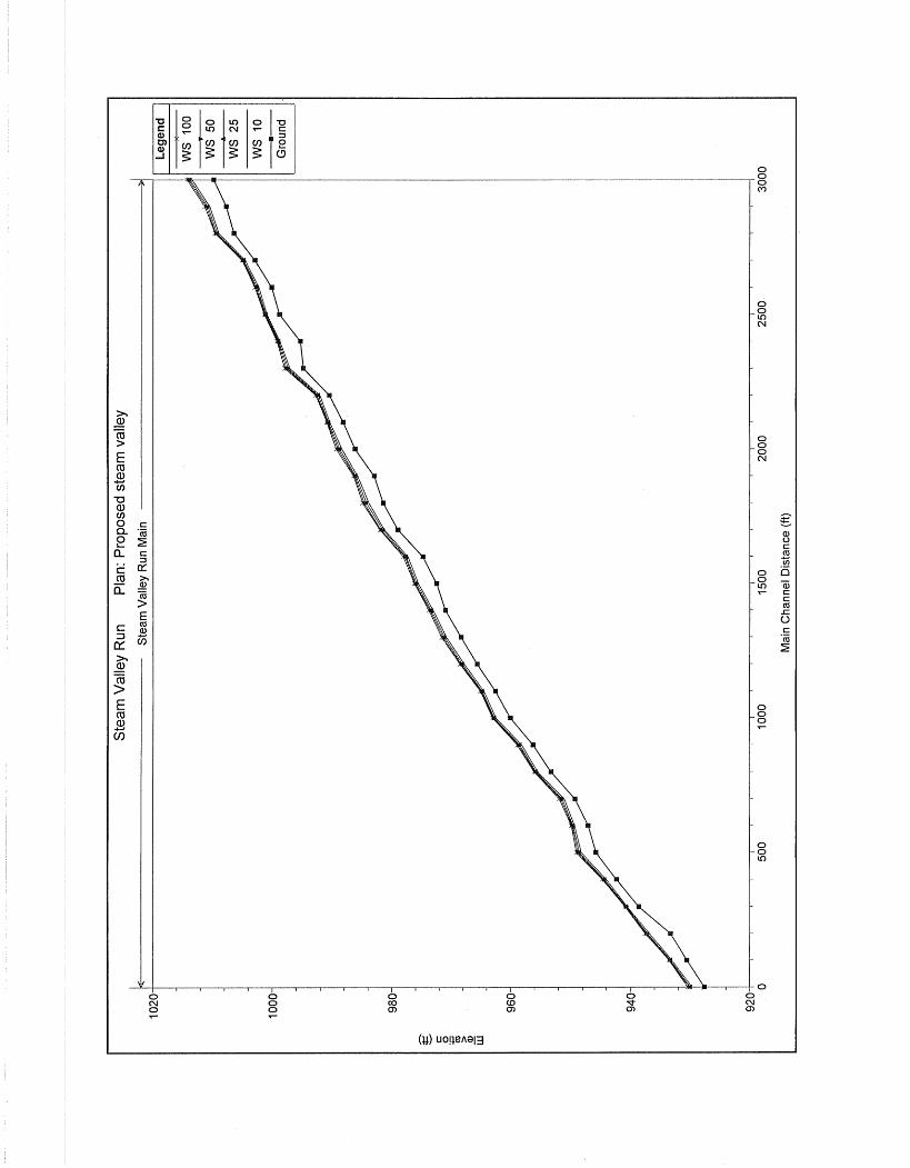
100 Year Flow and Velocity Comparisons – Existing vs. Proposed
River
Station
Flow (cfs)
Existing WSEL
(ft)
Proposed WSEL
(ft)
Change
(ft)
Existing Velocity
(ft/s)
Proposed Velocity
(ft/s)
Change
(ft/s) 4000 930 1014.25 1014.25 0.00 11.86 11.86 0.0 3900 930 1011.28 1011.28 0.00 13.52 13.52 0.0 3800 930 1009.89 1009.58 -0.31 10.94 11.30 0.36
2800 930 984.99 984.93 -0.06 9.99 8.26 -1.73 2700 930 982.03 982.03 0.00 8.30 8.30 0.00 2600 930 978.08 978.08 0.00 13.06 13.06 0.00 2500 930 976.23 976.23 0.00 11.06 11.06 0.00 2400 930 973.80 973.80 0.00 11.46 11.46 0.00 2300 930 971.63 971.63 0.00 10.77 10.77 0.00 2200 930 968.50 968.50 0.00 12.64 12.64 0.00
1300 930 940.72 940.73 0.01 13.14 11.55 -1.59 1200 930 937.62 937.62 0.00 10.16 10.72 0.56

State Route 15, Section C41 Stream Realignment
1100 930 933.56 933.56 0.00 11.76 11.46 -0.30 1000 930 930.45 930.45 0.00 11.28 11.47 0.19
I. SCOUR ANALYSIS
No scour analysis is required for the stream relocation.
J. RISK ASSESSMENT
The proposed stream relocation will have no adverse impacts on the public safety, public
health, or surrounding environment based on the following reasons: • The proposed relocation has no affect on either downstream or the upstream
water surface elevations between the existing and proposed analysis beyond the limits of the relocation.
• There are no dwellings in the area. Therefore, there is no threat to public safety.
K. CONSTRUCTION CONDITIONS
The existing stream will be maintained during the construction of the relocated channel. Upon completion of the relocated channel the existing stream will be filled in (See Cross
Sections in Appendix N) so that the flow can no longer follow the original course.
For construction access, four temporary channel crossings have been designed utilizing
either dual 30” or dual 36” smooth (Manning’s n=0.012) Pipes, or their hydraulic equivalent, as shown in Appendix N Temporary Conditions. Plan view locations and typical cross section
layout have been provided with appropriate pipe sizes labeled. The typical flow was calculated from an observed water depth of one foot and a typical channel width of twenty feet resulting in a flow of 143 cfs. The pipes were sized to pass the typical flow as calculated.
State Route 15, Section C41 Stream Realignment
L. ECONOMIC ANALYSIS
The relocation is required due the high cost and engineering difficulties of constructing retaining walls to contain the proposed roadway fill limits.
M. CONCLUSION
The proposed Stream Relocation does not show either an increase in water surface
elevations or an appreciable increase in velocities beyond the limits of the relocation. There is no increase in flooding risk to private parties as all work will be contained within the department right of way.


![Transportation Engineering - I - · PDF fileenough to Transportation Engineering - I nissan 3 URL: [1] INTRODUCTION TO TRANSPORTATION ENGINEERING Transportation](https://static.fdocuments.us/doc/165x107/5a8958357f8b9a4a268b45eb/transportation-engineering-i-to-transportation-engineering-i-nissan-3-url.jpg)