The collapse of a great medieval city suggests that ... collapse of a great medieval city suggests...
5
The End of Angkor The collapse of a great medieval city suggests that environmental miscalculations can spell doom for even the most highly engineered urban landscapes 10 MARCH 2006 VOL 311 SCIENCE www.sciencemag.org 1364 NEWSFOCUS SIEM REAP, CAMBODIA—Crouching in the bottom of a gully, Roland Fletcher traces with his finger the beveled edge of a pitted, grayish- red rock. The carved laterite block with a sloping face fits snugly in a groove in the block below. “It’s a fancy piece of work,” says Fletcher, an archaeologist at the University of Sydney, Australia. Centuries ago, the people of Angkor built immense sandstone palaces and temples on foundations of laterite, a spongy, iron-laden soil that hardens when exposed to air. In excavations begun last year, Fletcher’s team discovered that the half-meter-long block is just one piece of a dilapidated platform extending 20 meters underground in either direction. The platform appears to be the remnants of a massive spillway, possibly used to disperse flood- waters unleashed by monsoon rains. “Nobody had ever seen a structure of this kind here before,” Fletcher says. The spillway helps resolve one debate, showing that the majestic waterworks of Angkor—a Khmer kingdom from the 9th to 15th centuries C.E. that at its height encompassed much of modern-day Cambodia, central Thailand, and southern Vietnam—were designed for practi- cal purposes as well as religious rituals. But this singular piece of medieval engineering may also offer clues to a more profound rid- dle—not because the spillway exists, but because it was destroyed. Ever since Portuguese traders in the late 16th century described the lotus-shaped towers of Angkor Wat rising from the forest canopy, people have wondered why the once-gilded temple devoted to Vishnu—humanity’s largest religious mon- ument—and the city connected with it were abandoned about 500 years ago. The list of suspects proposed so far includes marauding invaders, a religious change of heart, and geological uplift. Now Fletcher and his colleagues have new evidence that the very grandeur of Angkor’s complex plumbing, the lifeblood of the city, left it vulnerable to collapse. In a provocative new interpretation of Angkor’s demise, Fletcher, co-director of the Greater Angkor Project (GAP), a 5-year survey and excavation sponsored by the Australian Research Council, proposes that the trigger may have been a com- bination of rigid infrastructure, environmental degradation, and abrupt changes in monsoons. He and other scholars caution that the case is not closed. “It’s hard to put a finger on any one reason for the collapse,” says Charles Higham, an anthropologist at the University of Otago in Dunedin, New Zealand, whose startling finds at earlier Thai sites are illuminating the origins of Angkor (see p. 1366). If the GAP team is right, Angkor—the most extensive city of its kind in the preindustrial world, with a population numbering in the hundreds of thousands in its heyday—would not be the first civilization unraveled by environmental change. For example, many archaeologists now hold that a series of devastating droughts doomed the Maya and their sprawling city-states on the Yucatán Peninsula between 800 and 900 C.E. Angkor’s downfall may be a cautionary tale for modern societies on the knife-edge of sustainability, such as Bangladesh. “The lesson to learn from all of this,” says Higham, “is don’t abuse the environment.” CREDITS (TOP TO BOTTOM): MUTSUMI STONE The collapse of a great medieval city suggests that environmental miscalculations can spell doom for even the most highly engineered urban landscapes Beguiling. A once-gilded Angkor Wat tower. The End of Angkor Published by AAAS
Transcript of The collapse of a great medieval city suggests that ... collapse of a great medieval city suggests...

The End of Angkor
The collapse of a great medieval city suggests that
environmental miscalculations can spell doom for
even the most highly engineered urban landscapes
10 MARCH 2006 VOL 311 SCIENCE www.sciencemag.org1364
NEWSFOCUS
SIEM REAP, CAMBODIA—Crouching in the
bottom of a gully, Roland Fletcher traces with
his finger the beveled edge of a pitted, grayish-
red rock. The carved laterite block with a
sloping face f its snugly in a groove in the
block below. “It’s a fancy piece of work,” says
Fletcher, an archaeologist at the University
of Sydney, Australia. Centuries ago, the
people of Angkor built immense
sandstone palaces and temples
on foundations of laterite, a
spongy, iron-laden soil that
hardens when exposed to air. In
excavations begun last year,
Fletcher’s team discovered that
the half-meter-long block is
just one piece of a dilapidated
platform extending 20 meters
underground in either direction.
The platform appears to be the
remnants of a massive spillway,
possibly used to disperse flood-
waters unleashed by monsoon
rains. “Nobody had ever seen a
structure of this kind here
before,” Fletcher says.
The spillway helps resolve
one debate, showing that the
majestic waterworks of Angkor—a Khmer
kingdom from the 9th to 15th centuries C.E.
that at its height encompassed much of
modern-day Cambodia, central Thailand, and
southern Vietnam—were designed for practi-
cal purposes as well as religious rituals. But
this singular piece of medieval engineering
may also offer clues to a more profound rid-
dle—not because the spillway exists, but
because it was destroyed.
Ever since Portuguese traders in the late
16th century described
the lotus-shaped towers
of Angkor Wat rising
from the forest canopy,
people have wondered
why the once-gilded
temple devoted to
Vishnu—humanity’s
largest religious mon-
ument—and the city
connected with it
were abandoned about
500 years ago. The list
of suspects proposed so
far includes marauding
invaders, a religious
change of heart, and geological uplift.
Now Fletcher and his colleagues have new
evidence that the very grandeur of Angkor’s
complex plumbing, the lifeblood of the city,
left it vulnerable to collapse. In a provocative
new interpretation of Angkor’s demise,
Fletcher, co-director of the Greater Angkor
Project (GAP), a 5-year survey and excavation
sponsored by the Australian Research Council,
proposes that the trigger may have been a com-
bination of rigid infrastructure, environmental
degradation, and abrupt changes in monsoons.
He and other scholars caution that the case is
not closed. “It’s hard to put a finger on any one
reason for the collapse,” says Charles Higham,
an anthropologist at the University of Otago in
Dunedin, New Zealand, whose startling finds
at earlier Thai sites are illuminating the origins
of Angkor (see p. 1366).
If the GAP team is right, Angkor—the most
extensive city of its kind in the preindustrial
world, with a population numbering in the
hundreds of thousands in its heyday—would
not be the f irst civilization unraveled by
environmental change. For example, many
archaeologists now hold that a series of
devastating droughts doomed the Maya and
their sprawling city-states on the Yucatán
Peninsula between 800 and 900 C.E.
Angkor’s downfall may be a cautionary tale
for modern societies on the knife-edge of
sustainability, such as Bangladesh. “The lesson
to learn from all of this,” says Higham, “is
don’t abuse the environment.” CR
ED
ITS
(T
OP
TO
BO
TT
OM
): M
UT
SU
MI S
TO
NE
The collapse of a great medieval city suggests that
environmental miscalculations can spell doom for
even the most highly engineered urban landscapes
Beguiling. A once-gilded
Angkor Wat tower.
The End of Angkor
Published by AAAS
Seeing the big picture
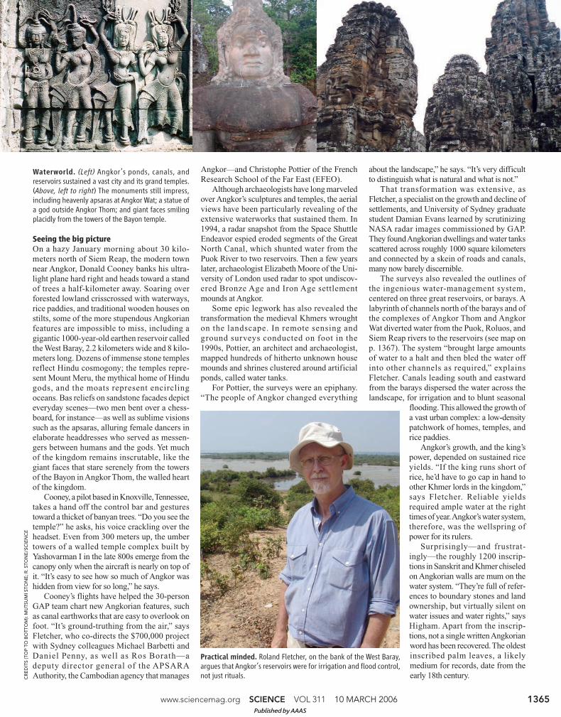
On a hazy January morning about 30 kilo-meters north of Siem Reap, the modern townnear Angkor, Donald Cooney banks his ultra-light plane hard right and heads toward a standof trees a half-kilometer away. Soaring overforested lowland crisscrossed with waterways,rice paddies, and traditional wooden houses onstilts, some of the more stupendous Angkorianfeatures are impossible to miss, including agigantic 1000-year-old earthen reservoir calledthe West Baray, 2.2 kilometers wide and 8 kilo-meters long. Dozens of immense stone templesreflect Hindu cosmogony; the temples repre-sent Mount Meru, the mythical home of Hindugods, and the moats represent encirclingoceans. Bas reliefs on sandstone facades depicteveryday scenes—two men bent over a chess-board, for instance—as well as sublime visionssuch as the apsaras, alluring female dancers inelaborate headdresses who served as messen-gers between humans and the gods. Yet muchof the kingdom remains inscrutable, like thegiant faces that stare serenely from the towersof the Bayon in Angkor Thom, the walled heartof the kingdom.
Cooney, a pilot based in Knoxville, Tennessee,takes a hand off the control bar and gesturestoward a thicket of banyan trees. “Do you see thetemple?” he asks, his voice crackling over theheadset. Even from 300 meters up, the umbertowers of a walled temple complex built byYashovarman I in the late 800s emerge from thecanopy only when the aircraft is nearly on top ofit. “It’s easy to see how so much of Angkor washidden from view for so long,” he says.
Cooney’s flights have helped the 30-personGAP team chart new Angkorian features, suchas canal earthworks that are easy to overlook onfoot. “It’s ground-truthing from the air,” saysFletcher, who co-directs the $700,000 projectwith Sydney colleagues Michael Barbetti andDaniel Penny, as well as Ros Borath—adeputy director general of the APSARAAuthority, the Cambodian agency that manages
Angkor—and Christophe Pottier of the FrenchResearch School of the Far East (EFEO).
Although archaeologists have long marveledover Angkor’s sculptures and temples, the aerialviews have been particularly revealing of theextensive waterworks that sustained them. In1994, a radar snapshot from the Space ShuttleEndeavor espied eroded segments of the GreatNorth Canal, which shunted water from thePuok River to two reservoirs. Then a few yearslater, archaeologist Elizabeth Moore of the Uni-versity of London used radar to spot undiscov-ered Bronze Age and Iron Age settlementmounds at Angkor.
Some epic legwork has also revealed thetransformation the medieval Khmers wroughton the landscape. In remote sensing andground surveys conducted on foot in the1990s, Pottier, an architect and archaeologist,mapped hundreds of hitherto unknown housemounds and shrines clustered around artificialponds, called water tanks.
For Pottier, the surveys were an epiphany.“The people of Angkor changed everything
about the landscape,” he says. “It’s very difficultto distinguish what is natural and what is not.”
That transformation was extensive, asFletcher, a specialist on the growth and decline ofsettlements, and University of Sydney graduatestudent Damian Evans learned by scrutinizingNASA radar images commissioned by GAP.They found Angkorian dwellings and water tanksscattered across roughly 1000 square kilometersand connected by a skein of roads and canals,many now barely discernible.
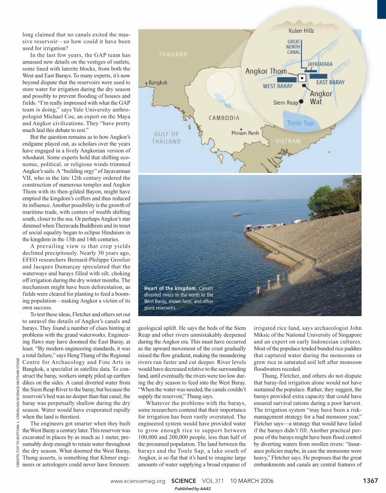
The surveys also revealed the outlines ofthe ingenious water-management system,centered on three great reservoirs, or barays. Alabyrinth of channels north of the barays and ofthe complexes of Angkor Thom and AngkorWat diverted water from the Puok, Roluos, andSiem Reap rivers to the reservoirs (see map onp. 1367). The system “brought large amountsof water to a halt and then bled the water offinto other channels as required,” explainsFletcher. Canals leading south and eastwardfrom the barays dispersed the water across thelandscape, for irrigation and to blunt seasonal
flooding. This allowed the growth ofa vast urban complex: a low-densitypatchwork of homes, temples, andrice paddies.
Angkor’s growth, and the king’spower, depended on sustained riceyields. “If the king runs short ofrice, he’d have to go cap in hand toother Khmer lords in the kingdom,”says Fletcher. Reliable yieldsrequired ample water at the righttimes of year. Angkor’s water system,therefore, was the wellspring ofpower for its rulers.
Surprisingly—and frustrat-ingly—the roughly 1200 inscrip-tions in Sanskrit and Khmer chiseledon Angkorian walls are mum on thewater system. “They’re full of refer-ences to boundary stones and landownership, but virtually silent onwater issues and water rights,” saysHigham. Apart from the inscrip-tions, not a single written Angkorianword has been recovered. The oldestinscribed palm leaves, a likelymedium for records, date from theearly 18th century.
www.sciencemag.org SCIENCE VOL 311 10 MARCH 2006 1365
CR
ED
ITS
(T
OP
TO
BO
TT
OM
): M
UT
SU
MI S
TO
NE
; R
. S
TO
NE
/SC
IEN
CE
Waterworld. (Left) Angkor’s ponds, canals, andreservoirs sustained a vast city and its grand temples.(Above, left to right) The monuments still impress,including heavenly apsaras at Angkor Wat; a statue ofa god outside Angkor Thom; and giant faces smilingplacidly from the towers of the Bayon temple.
Practical minded. Roland Fletcher, on the bank of the West Baray,argues that Angkor’s reservoirs were for irrigation and flood control,not just rituals.
Published by AAAS

10 MARCH 2006 VOL 311 SCIENCE www.sciencemag.org1366
CR
ED
ITS
: R
. S
TO
NE
/SC
IEN
CE
NEWSFOCUS
Angkor’s inscriptions also betray nothing
of the kingdom’s decline. By the 14th century,
“we really don’t know what’s going on in
Angkor,” says Fletcher. Siamese annals
recount how an army from a nearby kingdom
seized Angkor in 1431. Why the city was ulti-
mately abandoned is an enigma—although the
consequences must have been devastating.
“When a low-density city collapses,” Fletcher
says, “it takes out the entire region.”
Angkor’s past has remained mysterious in
part because Cambodia’s grim recent history
deterred research here. Civil war, the brutal
reign of the Khmer Rouge, and finally the inva-
sion of Vietnamese forces turned Angkor into a
no-go zone for nearly 20 years. Although the
heritage park with the major monuments is safe
for tourists, some terrain north of the barays
still has landmines and unexploded ordnance.
“You can’t go bushwalking here,” Fletcher says.
Fortunately, the warring sides left Angkor
largely untouched.
Then when Pottier reopened EFEO in 1992,
the emphasis was on restoring the temples.
Centuries of neglect had turned some com-
plexes into tumbled ruins, whereas others
required urgent measures to stabilize them or
restore sandstone facades. More than 20 teams
from around the world are working here, says
APSARA archaeologist So Peang. He points to
masons repairing a 12th century causeway that
bisects one of Angkor Wat’s moats. “Many
blocks have decayed. Rains wash away the
sands,” he says.
The vital repairs, not to mention efforts to
interpret the structures and inscriptions, have
conspired to keep attention riveted on the mon-
uments. “Archaeologists here have tended to
focus on what they can see,” Fletcher says.
“Imagine trying to learn about life in New York
City by only examining its churches.” As a
result, says Pottier, “Huge parts of the site
remain complete blanks.”
For that reason, one can stumble upon
hidden treasures. Walking on the bank of the
East Baray, Fletcher spots a triangular, dark-
gray object in the sandy grass. He picks up the
palm-sized stone fragment and points to some
squiggly lines. “It looks like old writing,” he
says. An EFEO expert later confirms that the
inscription is from the reign of Yashovarman I.
“So much here is just waiting to be discovered,”
Fletcher says.
Going with the flow
On the western edge of the Mebon, an artificial
island in the middle of the West Baray, a tangle
of grass and vines hides some laterite founda-
tions. Seventy years ago, during the dry season,
a villager looting the Mebon stumbled upon
part of a gigantic bronze torso jutting from the
muck near the foundations. He alerted an
EFEO curator, explaining that the Buddha told
him in a dream that he was buried in the Mebon
and couldn’t breathe. French excavations later
unearthed the 2-meter-tall head and shoulders
of a statue of Vishnu.
Beyond the baray, a swelling red sun is just
meeting the horizon. “Imagine the rays of the
setting sun glinting off Vishnu,” says Fletcher,
standing beside the remnants of the temple
wall. Pressure from the reservoir’s water column
would have forced water through the base of the
statue and out of Vishnu’s navel. Pollen grains
preserved in mud inside the temple show that
lotus plants flourished in the pond gracing
either side of a causeway leading from the
temple to the statue.
A controversy has simmered over whether
the magnificent Mebon and West Baray were
brought into being solely to inspire awe.
Some advocates of the purely ritual argument
Local Elites Cast New LightOn Angkor’s RisePHIMAI, THAILAND—In a square pit that couldswallow a two-story house, a dozen skeletonsare seeing the light of day for the first time in20 centuries. Two adults have more than a dozenseashell bangles on each arm, and a third has apair of marble bangles. In one corner, smallpainted clay pots contain infant bones. Aboveeach skull, of adults and children alike, lies asingle bivalve shell, probably representing
fertility or rebirth, says anthro-pologist Charles Higham, who is
excavating the Ban Non Wat siteoutside the city of Phimai.
At the edge of the pit,Higham points to a string
of pots jutting from thesoil below the layer ofthe skeletons. “These are
almost certainly from a ‘superburial,’ ” he says: anelite grave brimming with shell and marble jewelry and
bronze tools and ornaments. After a few more days of diggingearlier this month, his 60-strong team of academics, Thai laborers, andvolunteers from the conservation nonprofit Earthwatch Internationalcapped their field season by unearthing a clutch of ritualistic, princelyburials. These wealthy graves date from the Early Bronze Age, more than18 centuries before the civilization of Angkor rose to greatness.
Such early riches are helping to rework views of Angkor’s origins. Archae-ologists long thought that the import of Indian culture between 200 and
400 C.E., during the Iron Age, transformed scat-tered communities of benighted farmers into civi-lized societies. A smattering of Bronze Age digs inSoutheast Asia had yielded remarkably few gravegoods, creating a picture of farmers and fisherseking out hardscrabble lives. Elsewhere in Asia andin Europe, meanwhile, the advent of metalworkingin the early Bronze Age had clearly widened thegap between elites, merchants, and commoners.But Higham has uncovered a very different story.
From a patch of land half the size of anOlympic swimming pool, his team over five fieldseasons has unearthed 470 graves spanningthe Neolithic to the Iron Age, from 2200 B.C.E. to500 C.E. Most spectacular are the 3000-year-oldsuperburials. The team’s largely unpublishedfindings reveal that Southeast Asian societies werestratified into elite classes more than 1000 yearsbefore Indianization began. “By the Bronze Age,people here were sophisticated,” says Higham, ofthe University of Otago in Dunedin, New Zealand,
whose team includes Otago research fellow Rachanie Thosarat and NigelChang of James Cook University in Townsville, Australia.
Moreover, Higham says, the excavations show that the people of Phimai“were able to control water flow long before the development of Angkor’sreservoirs.” Those reservoirs and associated canals were vital to Angkor’spower (see main text).
Higham’s work is “pathbreaking,” says archaeologist Miriam Stark ofthe University of Hawaii, Manoa, who co-directs another dig in theregion. Ban Non Wat shows that Southeast Asia’s Bronze Age societieswere not out of step with the rest of the world. –R.S.
Rewriting history. Charles Higham’s team hasuncovered rich early graves, as shown by a pot froma Bronze Age superburial next to his left knee.
Published by AAAS
NEWSFOCUS
long claimed that no canals exited the mas-
sive reservoir—so how could it have been
used for irrigation?
In the last few years, the GAP team has
amassed new details on the vestiges of outlets,
some lined with laterite blocks, from both the
West and East Barays. To many experts, it’s now
beyond dispute that the reservoirs were used to
store water for irrigation during the dry season
and possibly to prevent flooding of houses and
fields. “I’m really impressed with what the GAP
team is doing,” says Yale University anthro-
pologist Michael Coe, an expert on the Maya
and Angkor civilizations. They “have pretty
much laid this debate to rest.”
But the question remains as to how Angkor’s
endgame played out, as scholars over the years
have engaged in a lively Angkorian version of
whodunit. Some experts hold that shifting eco-
nomic, political, or religious winds trimmed
Angkor’s sails. A “building orgy” of Jayavarman
VII, who in the late 12th century ordered the
construction of numerous temples and Angkor
Thom with its then-gilded Bayon, might have
emptied the kingdom’s coffers and thus reduced
its influence. Another possibility is the growth of
maritime trade, with centers of wealth shifting
south, closer to the sea. Or perhaps Angkor’s star
dimmed when Theravada Buddhism and its tenet
of social equality began to eclipse Hinduism in
the kingdom in the 13th and 14th centuries.
A prevailing view is that crop yields
declined precipitously. Nearly 30 years ago,
EFEO researchers Bernard-Philippe Groslier
and Jacques Dumarçay speculated that the
waterways and barays filled with silt, choking
off irrigation during the dry winter months. The
mechanism might have been deforestation, as
fields were cleared for planting to feed a boom-
ing population—making Angkor a victim of its
own success.
To test these ideas, Fletcher and others set out
to unravel the details of Angkor’s canals and
barays. They found a number of clues hinting at
problems with the grand waterworks. Engineer-
ing flaws may have doomed the East Baray, at
least. “By modern engineering standards, it was
a total failure,” says Heng Thung of the Regional
Centre for Archaeology and Fine Arts in
Bangkok, a specialist in satellite data. To con-
struct the baray, workers simply piled up earthen
dikes on the sides. A canal diverted water from
the Siem Reap River to the baray, but because the
reservoir’s bed was no deeper than that canal, the
baray was perpetually shallow during the dry
season. Water would have evaporated rapidly
when the land is thirstiest.
The engineers got smarter when they built
the West Baray a century later. This reservoir was
excavated in places by as much as 1 meter, pre-
sumably deep enough to retain water throughout
the dry season. What doomed the West Baray,
Thung asserts, is something that Khmer engi-
neers or astrologers could never have foreseen:
geological uplift. He says the beds of the Siem
Reap and other rivers unmistakably deepened
during the Angkor era. This must have occurred
as the upward movement of the crust gradually
raised the flow gradient, making the meandering
rivers run faster and cut deeper. River levels
would have decreased relative to the surrounding
land, until eventually the rivers were too low dur-
ing the dry season to feed into the West Baray.
“When the water was needed, the canals couldn’t
supply the reservoir,” Thung says.
Whatever the problems with the barays,
some researchers contend that their importance
for irrigation has been vastly overstated. The
engineered system would have provided water
to grow enough rice to support between
100,000 and 200,000 people, less than half of
the presumed population. The land between the
barays and the Tonle Sap, a lake south of
Angkor, is so flat that it’s hard to imagine large
amounts of water supplying a broad expanse of
irrigated rice land, says archaeologist John
Miksic of the National University of Singapore
and an expert on early Indonesian cultures.
Most of the populace tended bunded rice paddies
that captured water during the monsoons or
grew rice in saturated soil left after monsoon
floodwaters receded.
Thung, Fletcher, and others do not dispute
that baray-fed irrigation alone would not have
sustained the populace. Rather, they suggest, the
barays provided extra capacity that could have
ensured survival rations during a poor harvest.
The irrigation system “may have been a risk-
management strategy for a bad monsoon year,”
Fletcher says—a strategy that would have failed
if the barays didn’t fill. Another practical pur-
pose of the barays might have been flood control
by diverting waters from swollen rivers: “Insur-
ance policies maybe, in case the monsoons were
heavy,” Fletcher says. He proposes that the great
embankments and canals are central features of
www.sciencemag.org SCIENCE VOL 311 10 MARCH 2006 1367
CR
ED
ITS
(T
OP
TO
BO
TT
OM
): L
. C
RE
VE
LIN
G/S
CIE
NC
E; M
UT
SU
MI S
TO
NE
Heart of the kingdom. Canals
diverted rivers in the north to the
West Baray, shown here, and other
giant reservoirs.
Published by AAAS

10 MARCH 2006 VOL 311 SCIENCE www.sciencemag.org1368
CR
ED
ITS
: R
. S
TO
NE
/SC
IEN
CE
NEWSFOCUS
an artificial wetland aimed at reduc-
ing the risk of flood damage.
Remarkably, the GAP team is
the first to attempt a comprehensive
assessment of Angkor’s climate and
waterworks. Penny, an expert on
past climates, is analyzing pollen
grains to uncover shifts in vegeta-
tion cover. From this he hopes to
reconstruct changes in land use
during Angkor’s waning centuries.
So far, he says, results indicate that
Angkor’s demise was “patchy, both
over time and space,” undercutting
traditional explanations for the
city’s last days. Other scientists are
focused on the canals and barays—
and tackling the perplexing riddle of
the spillway.
Dowsing for the truth
The spillway might never have
come to light if Khmer Rouge
laborers hadn’t dug an irrigation
trench through it. Around the end of
the 9th century C.E., with Angkor
blossoming, engineers excavated a
long canal that altered the course of
the Siem Reap River, diverting it
southward to the East Baray. The
spillway extends westward from the
northern end of the canal and would
have functioned, Fletcher infers, to
protect that canal from excess
flooding, comparable to a bathtub’s
overflow slot.
The conundrum is that the spill-
way’s meticulous construction is
badly damaged. The Khmer Rouge
trench has largely eroded away; the
Angkorian workmanship was far
superior. Nevertheless, most of the
spillway’s laterite blocks lie in a
jumble under sandy soil. “It was
torn apart,” says Fletcher. It’s possible, he says,
that an engineering flaw caused the spillway to
give way. But Angkorian structures were built to
last, which propels Fletcher toward a different
conclusion. “It seems they ripped the spillway
out themselves,” he says. “Perhaps something
had gone wrong.”
Fletcher tends to see the hand of necessity,
not neglect. He hypothesizes that the structure
was damaged by flooding, then dismantled for
its materials, after which Angkor workers buried
the ruins to prevent the diversion canal from
breaking out of its channel and flowing west.
The story of the spillway and other clues
from the GAP team’s work indicate that over the
centuries, Angkor’s vaunted water system grew
ever more complex to support the sprawling city.
“We know that something was going wrong,
mechanically, with their water system,” Fletcher
says. For instance, one of the great southern
canals was filled with cross-bedded sand, indi-
cating considerable and rapid water flow as well
as sedimentation. “The sand buried the canals,”
he says. The water infrastructure “became so
inflexible, convoluted, and huge that it could
neither be replaced nor avoided, and had become
both too elaborate and too piecemeal.”
The more complicated and delicately bal-
anced the system grew, the harder it would have
been to compensate for unusual events, such as
extreme flooding or drought. “They engineered
a completely artificial environment, and it was a
fragile environment,” Pottier says.
Add climate change to this volatile mix, and
you have a recipe for disaster. The GAP team is
probing whether monsoons became “really
erratic” during the Little Ice Age, between
1300 and 1600 C.E. There’s good evidence that
cooling in the Northern Hemisphere not only
weakened monsoons in mainland Southeast
Asia during this period but also
triggered sharp declines in crop
yields in Europe. William Boyd, a
geologist at Southern Cross Uni-
versity in Lismore, Australia, who’s
collaborating with Higham, finds
GAP’s scenario reasonable; he
suspects that the Angkor region
would have become drier.
The idea is “really intriguing,”
says archaeologist Miriam Stark of
the University of Hawaii, Manoa,
who has studied the pre-Angkor
Funan kingdom of Cambodia’s
Mekong delta. But archaeologists
say more climate data are needed.
“A definitive answer,” says Miksic,
“would require a study of the ecol-
ogy of the Tonle Sap Basin over the
past 2000 years.”
Fletcher concurs, and he and
Penny hope to receive permission
from Cambodian authorities to go
caving in search of evidence. Stalag-
mites add new layers every year; the
isotopic chemistry of the layers cap-
tures a record of climatic conditions
during accrual. (Stark and Paul
Bishop of the University of Glasgow
hope to gather similar data from
caves in the Mekong delta region in
the coming year.) Deciphering the
isotope record in suitably old stalag-
mites should yield insights into past
climate. Other evidence could be
gleaned from changes in vegetation
or lake water levels, and Chinese
trade records, says Boyd.
As Angkor was rising, halfway
around the world a similar loss of
equilibrium brought the Maya to
their knees. Overpopulation and
environmental degradation had
weakened their Mesoamerican
cities. Beset by droughts and a “paroxysm of
warfare,” the civilization crumbled, Coe says.
“The demise of Angkor is directly comparable to
the great Maya collapse,” he says. And it could
happen again. “When populations in tropical
countries exceed the carrying capacity of the
land, real trouble begins,” Coe says.
Fletcher says there are lessons for developed
nations as well. He compares Angkor’s plumbing
woes to modern cities having to cope at great
cost with extensive, decaying sewers or cumber-
some road systems.
On their quest to understand the end of
Angkor, the GAP team will continue to excavate
and analyze deposits from its water features and
reconstruct its environmental history. Angkor,
says Thung, “is a never-ending story.” Or, rather,
it’s an ending often rewritten, and with a lesson
for society that gets gloomier each time.
–RICHARD STONE
Mapping in style. Donald Cooney’s bird’s-eye views of Angkor and itstemples (top) have helped researchers detect subtle features, such aseroded canal earthworks.
Published by AAAS