PART 3 Edition W - Maryland Nautical Buller to Cape Constance 100,000 3587w Harbours and Anchorages...
2
136 PART 3 W Antarctica Falkland Islands Islands in the Southern Ocean Chart No. Title of Chart or Plan Natural Scale 1: Date of Publication New Edition 225 w I Joinville Island to Cape Ducorps and Church Point 150,000 Apr. 1993 Nov. 2002 226 w I Deception Island 50,000 Mar. 2011 - Neptunes Bellows and Approaches 12,500 227 w I Church Point to Cape Longing including James Ross Island 150,000 Mar. 1994 Jan. 2004 446 w I Anvers Island to Renaud Island 150,000 Jan. 2001 May 2003 Port Lockroy 12,500 449 w I Elephant Island and Approaches 200,000 Apr. 2008 - 1614w Stanley Harbour and Approaches 30,000 Feb. 1986 Aug. 2009 Stanley Harbour 12,500 1740w I Bond Point to Brunow Bay 35,000 May 2004 - Juan Carlos 1 Base 5,000 Half Moon Island 25,000 1741w I Plans in Greenwich Island - June 2006 - A Discovery Bay 20,000 B Iquique Cove and Approaches 5,000 1774w Plans in the South Shetland Islands - Sept. 1962 Oct. 1994 Yankee Harbour 15,000 Harmony Cove 25,000 Marian Cove and Potter Cove 25,000 Visca Anchorage 25,000 Ardley Cove 30,000 English Strait 30,000 Desolation Island 50,000 Admiralty Bay and King George Bay 100,000 1775w South Orkney Islands 200,000 Aug. 1934 Jan. 1997 A Powell Island and Washington Strait 100,000 B Scotia Bay and Mill Cove 25,000 C Ellefsen Harbour 12,500 F Uruguay Cove 25,000 G Sandefjord Bay 25,000 1776w Livingston Island to King George Island 200,000 July 1968 Jan. 1991 1779w I Approaches to Signy Island 50,000 Apr. 2006 - Borge Bay and Approaches 10,000 2398w Îles Kerguelen 300,000 Aug. 1984 Feb. 2011 Baie du Morbihan 75,000 2505w Approaches to the Falkland Islands 1,500,000 Nov. 1983 Sept. 2010 2506w Mare Harbour and Approaches 12,500 July 1983 Aug. 2009 2507w Pebble Island to Port Fitzroy 150,000 Nov. 1988 Aug. 2009 2508w Port Fitzroy to Eagle Passage 150,000 July 1991 Aug. 2009 2512w The Falkland Islands 400,000 July 1984 Sept. 2009 2513w Eagle Passage to New Island 150,000 Aug. 1983 Sept. 2009 New Island 35,000 2514w New Island to Pebble Island 150,000 Apr. 1983 Aug. 2009 Hope Harbour 50,000 2525w Choiseul Sound 25,000 Nov. 2000 Sept. 2009 Continuation to Choiseul Sound 25,000 2526w Byron Sound to Jason Islands 80,000 Nov. 2000 Aug. 2009 2527w Port Albemarle 25,000 Nov. 2000 Sept. 2009 2536w Port William to Choiseul Sound 75,000 Mar. 1983 Aug. 2009 2543w Anchorages in West Falkland Island - Dec. 1982 Sept. 2009 Fox Bay 30,000 Port Edgar 30,000 Smylie Channel 50,000 Port Stephens and Port Albemarle 75,000 2544w Passages in West Falkland Islands - June 1976 Sept. 2009 North-west Passage 15,000 Christmas Harbour 25,000 2545w Port Egmont to Port Purvis 50,000 June 1978 Aug. 2009 2546w Approaches to Port Salvador 75,000 Sept. 1977 Aug. 2009 Port Salvador 30,000 2547w Port Salvador to Port William 75,000 Dec. 1982 Aug. 2009 2550w Plans in East Falkland Island - Feb. 1986 Aug. 2009 A Darwin Harbour 20,000 B Darwin Narrows 7,500 C Berkeley Sound 37,500 D Port Fitzroy 37,500 Chart No. Title of Chart or Plan Natural Scale 1: Date of Publication New Edition 2558w Falkland Sound – Northern Part 75,000 Oct. 1978 Aug. 2009 2559w Falkland Sound – Southern Part 75,000 May 1978 Sept. 2009 2560w Lively Sound to Eagle Passage 75,000 July 1978 Sept. 2009 A Bull Roads 37,500 B Bleaker Jump 25,000 2561w Choiseul Sound and Adventure Sound 75,000 Jan. 1980 Sept. 2009 2582w Plans in Falkland Sound - Oct. 1986 Sept. 2009 Port Howard 25,000 Port San Carlos and San Carlos Water 25,000 Brenton Loch 35,000 Egg Harbour 35,000 3200w Falkland Islands to South Sandwich Islands and Graham Land 3,750,000 Dec. 1995 July 2011 3205w South Shetland Islands and Bransfield Strait 500,000 Sept. 1949 Aug. 2011 3213w Plans in Graham Land - Aug. 1960 Aug. 1973 Detaille Island 7,500 Mutton Cove 10,000 Arthur Harbour 12,500 Hackapike Bay 15,000 Debenham Islands 25,000 Hope Bay 30,000 Melchior Islands 35,000 Approaches to Prospect Point 50,000 Approaches to Danco Island 50,000 Lystad Bay 50,000 Neny Island 50,000 3462w I British Antarctic Survey Base Rothera 25,000 Jan. 1980 Dec. 1999 3560w Gerlache Strait – Northern Part 200,000 Apr. 1961 Sept. 1988 3566w Gerlache Strait – Southern Part 200,000 Oct. 1959 Oct. 1988 3570w Brabant Island to Adelaide Island 500,000 Jan. 1951 July 2011 3571w Lavoisier Island to Alexander Island 500,000 Sept. 1952 July 2011 3573w Grandidier Channel 200,000 Aug. 1960 Dec. 1987 3575w I Argentine Islands and Approaches 60,000 July 1988 Oct. 1996 Argentine Islands 15,000 3577w Adelaide Island – South Western Approaches 75,000 Aug. 1964 Mar. 1995 Adelaide Anchorage 30,000 3580w Rothera Point to Neny Island 100,000 Dec. 1982 Sept. 1995 3585w Harbours and Anchorages in South Georgia - Sept. 1931 May 1986 Prince Olav Harbour and Approaches 12,500 Prince Olav Harbour – North Bay 3,600 Larsen Harbour 10,000 Blue Whale Harbour 12,500 Elsehul 12,500 Rosita Harbour 12,500 Right Whale Bay 12,500 Undine Harbour 17,500 Fortuna Bay 30,000 Gold Harbour 30,000 Moltke Harbour 40,000 Cape Buller to Cape Constance 100,000 3587w Harbours and Anchorages in South Georgia - Jan. 1996 Jan. 2003 A Maiviken 12,500 B King Edward Cove 7,500 C Jason Harbour 12,500 D Cobblers Cove 7,500 E Godthul 25,000 F Dartmouth Point Anchorage 12,500 G Approaches to Leith, Stromness and Husvik Harbours 15,000 3588w Approaches to Stromness and Cumberland Bays 50,000 Jan. 2001 Jan. 2003 3592w A Approaches to Stewart Strait 100,000 Sept. 1962 Jan. 2000 B Stewart Strait 25,000 C Bird Sound 12,500 3593w Approaches to the South Sandwich Islands 500,000 Sept. 1989 Sept. 2003 A Nelson Channel 50,000 B Cordelia Bay 50,000 C Douglas Strait 50,000 3596w Approaches to South Georgia 750,000 Sept. 1988 Jan. 2002 Chart No. Title of Chart or Plan Natural Scale 1: Date of Publication New Edition 3597w South Georgia 250,000 May 1958 Apr. 1988 3629w I Approaches to Halley Base 200,000 Mar. 2005 - 3707w I Mill Island to Cape Poinsett 500,000 Sept. 1999 - 3710w I Cape Hooker to Coulman Island 500,000 Mar. 2005 - 3711w I Cape Adare to Cape Daniell 200,000 Mar. 2005 July 2007 3714w I Cape Adare and Cape Hallett - Oct. 2005 July 2007 A Cape Adare 50,000 B Ridley Beach 15,000 C Cape Hallett 50,000 D Seabee Hook 15,000 3716w I Possession Islands 60,000 Oct. 2005 July 2007 4020w I South Atlantic Ocean – Western Part 10,000,000 Dec. 1982 May 2003 4021w I South Atlantic Ocean – Eastern Part 10,000,000 Dec. 1975 Jan. 2003 4022w I South America to Africa 10,000,000 Dec. 1982 June 2011 4024w I Weddell Sea to Mar del Plata 10,000,000 Sept. 1987 Mar. 2011 4060w I Australasia and Adjacent Waters 10,000,000 June 1989 May 2003 4061w I South Pacific Ocean – Western Portion 10,000,000 Mar. 1988 Dec. 2003 4062w I South Pacific Ocean – Eastern Part 10,000,000 Dec. 1985 Sept. 2011 4063w Bellingshausen Sea to Valdivia 10,000,000 Sept. 1987 Nov. 2010 Peter I Øy 300,000 4064w I Marie Byrd Land to Southwest Pacific Basin 10,000,000 Dec. 1986 Mar. 2011 4065w I Ross Sea to New Zealand 10,000,000 Dec. 1995 Mar. 2011 4070w I Indian Ocean – Southern Part 10,000,000 Mar. 1975 June 2011 4072w I Indian Ocean – Western Part 10,000,000 June 1979 Feb. 2011 4073w I Indian Ocean – Eastern Part 10,000,000 June 1979 Apr. 2011 4074w I Cape Darnley to Tasmania 10,000,000 Jan. 1983 Mar. 2011 4075w I Kapp Norvegia to Îles Kerguelen 10,000,000 Nov. 1984 Mar. 2011 4206w Tristan da Cunha Group to Discovery Seamounts and Islas Orcadas Rise 3,500,000 Feb. 1979 Feb. 2011 4207w Falkland Islands to Cabo Corrientes and Northeast Georgia Rise 3,500,000 Sept. 1980 Apr. 2003 4212w Drake Passage 3,500,000 Jan. 1985 June 2002 4213w Scotia Sea 3,500,000 Jan. 1985 Mar. 2011 4601w I South Pacific Ocean – Tasman Sea 3,500,000 Sept. 1974 Feb. 2011 4609w I Valparaíso to Islas Diego Ramírez 3,500,000 Mar. 1981 Nov. 2010 4610w Pacific – Antarctic Rise to Southeast Pacific Basin 3,500,000 Sept. 1979 Mar. 2011 4611w Southwest Pacific Basin to Pacific – Antarctic Rise 3,500,000 June 1979 Mar. 2011 4612w Chatham Islands to Pacific – Antarctic Rise 3,500,000 Sept. 1979 Mar. 2011 4614w Île Rapa to Pacific – Antarctic Rise 3,500,000 Dec. 1978 Mar. 2011 4616w Isla de Pascua to Chile Rise 3,500,000 Oct. 1979 Mar. 2011 4708w I Australia – West Coast 3,500,000 Jan. 1977 Apr. 2006 4709w I Australia – South Coast 3,500,000 Jan. 1977 Apr. 2006 4710w I Cape Leeuwin to Southeast Indian Ridge 3,500,000 Nov. 1978 Jan. 2002 4711w Île Amsterdam to Îles Kerguelen 3,500,000 Nov. 1978 Mar. 2011 4712w Îles Crozet to Prince Edward Islands 3,500,000 Apr. 1979 Mar. 2011 4713w Île de la Réunion to Île Saint-Paul 3,500,000 Feb. 1978 Aug. 2010 4714w I Cocos (Keeling) Islands to Île Saint Paul 3,500,000 Feb. 1978 Oct. 2005 4726w I Cape Leeuwin to Esperance 1,500,000 Mar. 1989 June 2011 4900w I Ross Sea 2,000,000 Mar. 1999 Nov. 2003 4904w I Dronning Maud Land 2,000,000 Sept. 2004 - 4906w I Weddell Sea 2,000,000 Oct. 2005 - 4907w I Approaches to the Antarctic Peninsula 2,000,000 Dec. 2000 Nov. 2010 Key to symbols w ARCS version. See page 14. i International Chart. See pages 176 -177.
Transcript of PART 3 Edition W - Maryland Nautical Buller to Cape Constance 100,000 3587w Harbours and Anchorages...

136
PART 3
W
AntarcticaFalkland IslandsIslands in the Southern Ocean
Chart No. Title of Chart or Plan Natural Scale 1:
Date ofPublication
New Edition
225 wI Joinville Island to Cape Ducorps and Church Point 150,000 Apr. 1993 Nov. 2002226 wI Deception Island 50,000 Mar. 2011 -
Neptunes Bellows and Approaches 12,500227 wI Church Point to Cape Longing including James Ross Island 150,000 Mar. 1994 Jan. 2004446 wI Anvers Island to Renaud Island 150,000 Jan. 2001 May 2003
Port Lockroy 12,500449 wI Elephant Island and Approaches 200,000 Apr. 2008 -1614w Stanley Harbour and Approaches 30,000 Feb. 1986 Aug. 2009
Stanley Harbour 12,5001740wI Bond Point to Brunow Bay 35,000 May 2004 -
Juan Carlos 1 Base 5,000Half Moon Island 25,000
1741wI Plans in Greenwich Island - June 2006 -A Discovery Bay 20,000B Iquique Cove and Approaches 5,000
1774w Plans in the South Shetland Islands - Sept. 1962 Oct. 1994Yankee Harbour 15,000Harmony Cove 25,000Marian Cove and Potter Cove 25,000Visca Anchorage 25,000Ardley Cove 30,000English Strait 30,000Desolation Island 50,000Admiralty Bay and King George Bay 100,000
1775w South Orkney Islands 200,000 Aug. 1934 Jan. 1997A Powell Island and Washington Strait 100,000B Scotia Bay and Mill Cove 25,000C Ellefsen Harbour 12,500F Uruguay Cove 25,000G Sandefjord Bay 25,000
1776w Livingston Island to King George Island 200,000 July 1968 Jan. 19911779wI Approaches to Signy Island 50,000 Apr. 2006 -
Borge Bay and Approaches 10,0002398w Îles Kerguelen 300,000 Aug. 1984 Feb. 2011
Baie du Morbihan 75,0002505w Approaches to the Falkland Islands 1,500,000 Nov. 1983 Sept. 20102506w Mare Harbour and Approaches 12,500 July 1983 Aug. 20092507w Pebble Island to Port Fitzroy 150,000 Nov. 1988 Aug. 20092508w Port Fitzroy to Eagle Passage 150,000 July 1991 Aug. 20092512w The Falkland Islands 400,000 July 1984 Sept. 20092513w Eagle Passage to New Island 150,000 Aug. 1983 Sept. 2009
New Island 35,0002514w New Island to Pebble Island 150,000 Apr. 1983 Aug. 2009
Hope Harbour 50,0002525w Choiseul Sound 25,000 Nov. 2000 Sept. 2009
Continuation to Choiseul Sound 25,0002526w Byron Sound to Jason Islands 80,000 Nov. 2000 Aug. 20092527w Port Albemarle 25,000 Nov. 2000 Sept. 20092536w Port William to Choiseul Sound 75,000 Mar. 1983 Aug. 20092543w Anchorages in West Falkland Island - Dec. 1982 Sept. 2009
Fox Bay 30,000Port Edgar 30,000Smylie Channel 50,000Port Stephens and Port Albemarle 75,000
2544w Passages in West Falkland Islands - June 1976 Sept. 2009North-west Passage 15,000Christmas Harbour 25,000
2545w Port Egmont to Port Purvis 50,000 June 1978 Aug. 20092546w Approaches to Port Salvador 75,000 Sept. 1977 Aug. 2009
Port Salvador 30,0002547w Port Salvador to Port William 75,000 Dec. 1982 Aug. 20092550w Plans in East Falkland Island - Feb. 1986 Aug. 2009
A Darwin Harbour 20,000B Darwin Narrows 7,500C Berkeley Sound 37,500D Port Fitzroy 37,500
Chart No. Title of Chart or Plan Natural Scale 1:
Date ofPublication
New Edition
2558w Falkland Sound – Northern Part 75,000 Oct. 1978 Aug. 20092559w Falkland Sound – Southern Part 75,000 May 1978 Sept. 20092560w Lively Sound to Eagle Passage 75,000 July 1978 Sept. 2009
A Bull Roads 37,500B Bleaker Jump 25,000
2561w Choiseul Sound and Adventure Sound 75,000 Jan. 1980 Sept. 20092582w Plans in Falkland Sound - Oct. 1986 Sept. 2009
Port Howard 25,000Port San Carlos and San Carlos Water 25,000Brenton Loch 35,000Egg Harbour 35,000
3200w Falkland Islands to South Sandwich Islands and Graham Land 3,750,000 Dec. 1995 July 20113205w South Shetland Islands and Bransfi eld Strait 500,000 Sept. 1949 Aug. 20113213w Plans in Graham Land - Aug. 1960 Aug. 1973
Detaille Island 7,500Mutton Cove 10,000Arthur Harbour 12,500Hackapike Bay 15,000Debenham Islands 25,000Hope Bay 30,000Melchior Islands 35,000Approaches to Prospect Point 50,000Approaches to Danco Island 50,000Lystad Bay 50,000Neny Island 50,000
3462wI British Antarctic Survey Base Rothera 25,000 Jan. 1980 Dec. 19993560w Gerlache Strait – Northern Part 200,000 Apr. 1961 Sept. 19883566w Gerlache Strait – Southern Part 200,000 Oct. 1959 Oct. 19883570w Brabant Island to Adelaide Island 500,000 Jan. 1951 July 20113571w Lavoisier Island to Alexander Island 500,000 Sept. 1952 July 20113573w Grandidier Channel 200,000 Aug. 1960 Dec. 19873575wI Argentine Islands and Approaches 60,000 July 1988 Oct. 1996
Argentine Islands 15,0003577w Adelaide Island – South Western Approaches 75,000 Aug. 1964 Mar. 1995
Adelaide Anchorage 30,0003580w Rothera Point to Neny Island 100,000 Dec. 1982 Sept. 19953585w Harbours and Anchorages in South Georgia - Sept. 1931 May 1986
Prince Olav Harbour and Approaches 12,500Prince Olav Harbour – North Bay 3,600Larsen Harbour 10,000Blue Whale Harbour 12,500Elsehul 12,500Rosita Harbour 12,500Right Whale Bay 12,500Undine Harbour 17,500Fortuna Bay 30,000Gold Harbour 30,000Moltke Harbour 40,000Cape Buller to Cape Constance 100,000
3587w Harbours and Anchorages in South Georgia - Jan. 1996 Jan. 2003A Maiviken 12,500B King Edward Cove 7,500C Jason Harbour 12,500D Cobblers Cove 7,500E Godthul 25,000F Dartmouth Point Anchorage 12,500G Approaches to Leith, Stromness and Husvik Harbours 15,000
3588w Approaches to Stromness and Cumberland Bays 50,000 Jan. 2001 Jan. 20033592w A Approaches to Stewart Strait 100,000 Sept. 1962 Jan. 2000
B Stewart Strait 25,000C Bird Sound 12,500
3593w Approaches to the South Sandwich Islands 500,000 Sept. 1989 Sept. 2003A Nelson Channel 50,000B Cordelia Bay 50,000C Douglas Strait 50,000
3596w Approaches to South Georgia 750,000 Sept. 1988 Jan. 2002
Chart No. Title of Chart or Plan Natural Scale 1:
Date ofPublication
New Edition
3597w South Georgia 250,000 May 1958 Apr. 19883629wI Approaches to Halley Base 200,000 Mar. 2005 -3707wI Mill Island to Cape Poinsett 500,000 Sept. 1999 -3710wI Cape Hooker to Coulman Island 500,000 Mar. 2005 -3711wI Cape Adare to Cape Daniell 200,000 Mar. 2005 July 20073714wI Cape Adare and Cape Hallett - Oct. 2005 July 2007
A Cape Adare 50,000B Ridley Beach 15,000C Cape Hallett 50,000D Seabee Hook 15,000
3716wI Possession Islands 60,000 Oct. 2005 July 20074020wI South Atlantic Ocean – Western Part 10,000,000 Dec. 1982 May 20034021wI South Atlantic Ocean – Eastern Part 10,000,000 Dec. 1975 Jan. 20034022wI South America to Africa 10,000,000 Dec. 1982 June 20114024wI Weddell Sea to Mar del Plata 10,000,000 Sept. 1987 Mar. 20114060wI Australasia and Adjacent Waters 10,000,000 June 1989 May 20034061wI South Pacifi c Ocean – Western Portion 10,000,000 Mar. 1988 Dec. 20034062wI South Pacifi c Ocean – Eastern Part 10,000,000 Dec. 1985 Sept. 20114063w Bellingshausen Sea to Valdivia 10,000,000 Sept. 1987 Nov. 2010
Peter I Øy 300,0004064wI Marie Byrd Land to Southwest Pacifi c Basin 10,000,000 Dec. 1986 Mar. 20114065wI Ross Sea to New Zealand 10,000,000 Dec. 1995 Mar. 20114070wI Indian Ocean – Southern Part 10,000,000 Mar. 1975 June 20114072wI Indian Ocean – Western Part 10,000,000 June 1979 Feb. 20114073wI Indian Ocean – Eastern Part 10,000,000 June 1979 Apr. 20114074wI Cape Darnley to Tasmania 10,000,000 Jan. 1983 Mar. 20114075wI Kapp Norvegia to Îles Kerguelen 10,000,000 Nov. 1984 Mar. 20114206w Tristan da Cunha Group to Discovery Seamounts and Islas Orcadas Rise 3,500,000 Feb. 1979 Feb. 20114207w Falkland Islands to Cabo Corrientes and Northeast Georgia Rise 3,500,000 Sept. 1980 Apr. 20034212w Drake Passage 3,500,000 Jan. 1985 June 20024213w Scotia Sea 3,500,000 Jan. 1985 Mar. 20114601wI South Pacifi c Ocean – Tasman Sea 3,500,000 Sept. 1974 Feb. 20114609wI Valparaíso to Islas Diego Ramírez 3,500,000 Mar. 1981 Nov. 20104610w Pacifi c – Antarctic Rise to Southeast Pacifi c Basin 3,500,000 Sept. 1979 Mar. 20114611w Southwest Pacifi c Basin to Pacifi c – Antarctic Rise 3,500,000 June 1979 Mar. 20114612w Chatham Islands to Pacifi c – Antarctic Rise 3,500,000 Sept. 1979 Mar. 20114614w Île Rapa to Pacifi c – Antarctic Rise 3,500,000 Dec. 1978 Mar. 20114616w Isla de Pascua to Chile Rise 3,500,000 Oct. 1979 Mar. 20114708wI Australia – West Coast 3,500,000 Jan. 1977 Apr. 20064709wI Australia – South Coast 3,500,000 Jan. 1977 Apr. 20064710wI Cape Leeuwin to Southeast Indian Ridge 3,500,000 Nov. 1978 Jan. 20024711w Île Amsterdam to Îles Kerguelen 3,500,000 Nov. 1978 Mar. 20114712w Îles Crozet to Prince Edward Islands 3,500,000 Apr. 1979 Mar. 20114713w Île de la Réunion to Île Saint-Paul 3,500,000 Feb. 1978 Aug. 20104714wI Cocos (Keeling) Islands to Île Saint Paul 3,500,000 Feb. 1978 Oct. 20054726wI Cape Leeuwin to Esperance 1,500,000 Mar. 1989 June 20114900wI Ross Sea 2,000,000 Mar. 1999 Nov. 20034904wI Dronning Maud Land 2,000,000 Sept. 2004 -4906wI Weddell Sea 2,000,000 Oct. 2005 -4907wI Approaches to the Antarctic Peninsula 2,000,000 Dec. 2000 Nov. 2010
Key to symbols
w ARCS version. See page 14.
i International Chart. See pages 176-177.
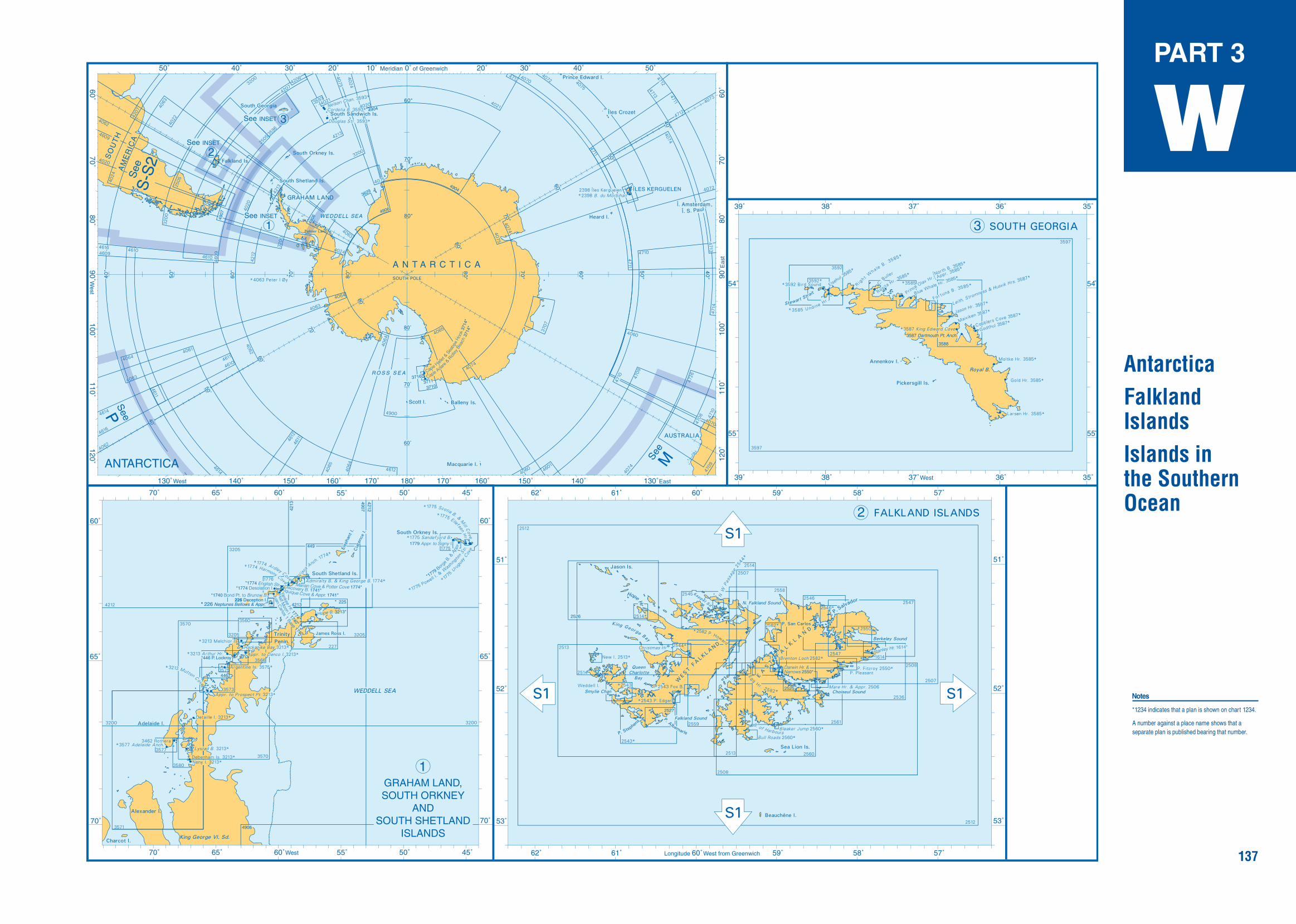
137
PART 3
W
AntarcticaFalkland IslandsIslands in the Southern Ocean
Notes
*1234 indicates that a plan is shown on chart 1234.
A number against a place name shows that a separate plan is published bearing that number.
S-S
2S
-S2
P
M
226 Deception I.* 226 Neptunes Bellows & Appr.