
PART 2...PART 2 SITE PLANNING PART 2 TOC - 2 Parramatta Development Control Plan 2011 CONTENTS 2.1...
24
PART 2 SITE PLANNING
Transcript of PART 2...PART 2 SITE PLANNING PART 2 TOC - 2 Parramatta Development Control Plan 2011 CONTENTS 2.1...

PART 2SITE PLANNING

PART
2
TOC - 2 Parramatta Development Control Plan 2011
CONTENTS2.1 Design in Context in Parramatta City 2-1
2.2 Requirements for Submitting a Development Application 2-4
2.3 Site Analysis 2-4
2.4 Site Considerations 2-5
2.4.1 Views and Vistas 2-5
2.4.2 Water Management 2-62.4.2.1 Flooding 2-62.4.2.2 Protection of Waterways 2-122.4.2.3 Protection of Groundwater 2-13
2.4.3 Soil Management 2-132.4.3.1 Sedimentation 2-132.4.3.2 Acid Sulfate Soils 2-152.4.3.3 Salinity 2-16
2.4.4 Land Contamination 2-16
2.4.5 Air Quality 2-18
2.4.6 Development on Sloping Land 2-18
2.4.7 Biodiversity 2-192.4.7.1 General 2-192.4.7.2 Development on land abutting the E2 Environmental Protection zone and W1
Natural Waterways zone 2-20
2.4.8 Public Domain 2-20
PART
2
2.1
Parramatta Development Control Plan 2011 2 - 1
DESiGN iN CoNtExt iN PArrAmAttA City
2.1 Design in Context in Parramatta CityIn the context of Sydney, Parramatta City is located at the head of Sydney Harbour at the edge of the Cumberland Basin. On either side of the Parramatta River, the City’s topography is generally characterised by hills and valleys to the north, and the Cumberland Plain to the south. The City’s centre is located between the hills and the Plain, and along the banks of the Parramatta River. The River’s tributaries and adjacent open space corridors extend as fingers through the City.
A number of hard physical elements traverse the City including the Western Railway, the M4 Motorway and regional main roads such as Woodville Road, Pennant Hills Road, Parramatta Road and Windsor Road. Large pockets of institutional and industrial land uses also differentiate the City including the Westmead Medical Precinct, the University of Western Sydney and the Camellia-Rydalmere Industrial Precinct. Parramatta Park, Rosehill Racecourse, and the Parramatta Speedway are recreational uses that cover substantial areas of the City. Commercial centres such as Carlingford, Epping and Granville, as well as a mix of smaller neighbourhood centres, also contribute to Parramatta’s diverse urban fabric.
These elements have a significant impact on the form and function of localities. Designing in context, recognising these broader spatial dynamics of the City, and refining an urban design framework consistent with the objectives of the planning framework, will ensure the future physical form of Parramatta kindles a sustainable, energetic and healthy community.
When designing a development for a site it is essential to respond to the local and broader urban context by identifying the area’s defining elements. The design should be informed by this.
In order to understand this context, a site analysis (at an appropriate scale) should be undertaken as a first step in preparing for a development. This should identify the opportunities and constraints of the site and create a platform from which to develop a design. A site analysis demonstrates that the proposed development is the best possible solution and makes the best contribution to its surroundings.
The site analysis should include:
� The urban structure including property boundaries, street network and public spaces
� The land uses
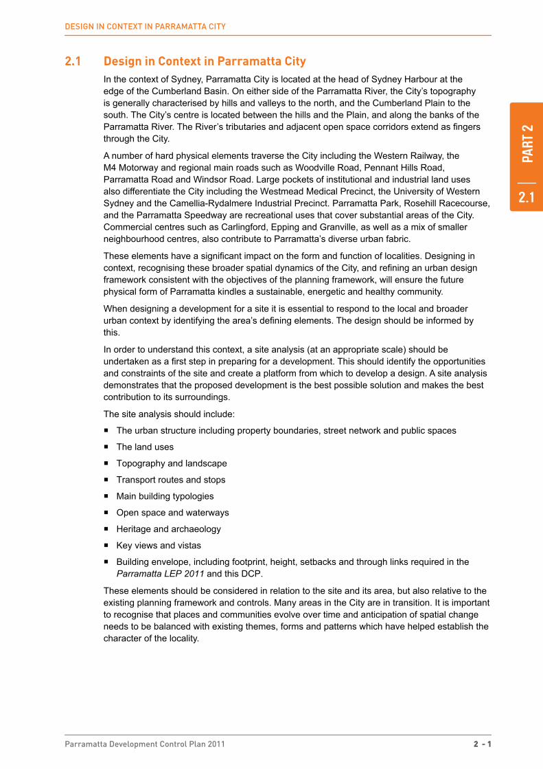
� Topography and landscape
� Transport routes and stops
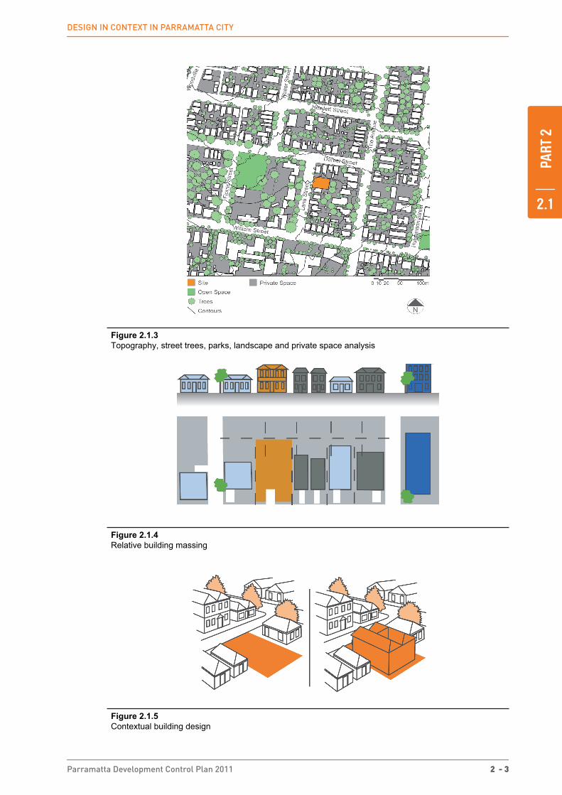
� Main building typologies
� Open space and waterways
� Heritage and archaeology
� Key views and vistas
� Building envelope, including footprint, height, setbacks and through links required in the Parramatta LEP 2011 and this DCP.
These elements should be considered in relation to the site and its area, but also relative to the existing planning framework and controls. Many areas in the City are in transition. It is important to recognise that places and communities evolve over time and anticipation of spatial change needs to be balanced with existing themes, forms and patterns which have helped establish the character of the locality.

PART
2
2.1
2 - 2 Parramatta Development Control Plan 2011
DESiGN iN CoNtExt iN PArrAmAttA City
Figure 2.1.1 Context analysis
Figure 2.1.2 Built form and height analysis
PART
2
2.1
Parramatta Development Control Plan 2011 2 - 3
DESiGN iN CoNtExt iN PArrAmAttA City
Figure 2.1.3 Topography, street trees, parks, landscape and private space analysis
Figure 2.1.4 Relative building massing
Figure 2.1.5 Contextual building design
PART
2
2.2
2 - 4 Parramatta Development Control Plan 2011
rEquirEmENtS For SubmittiNG A DEvEloPmENt APPliCAtioN
2.2 Requirements for Submitting a Development ApplicationFor advice on the information required to be submitted with a development application, please contact Council’s Development Services Unit.
Appendix 2 contains information on Council’s procedures for Notification of Development Applications.
2.3 Site Analysis All development applications should submit a site analysis, except development applications for the purposes of:
� Change of use
� Minor alterations and additions, and
� Swimming pools.
The degree of detail required will vary according to the nature, type and scale of the development and its surroundings. The level of detail required should be clarified with Council’s development assessment officers. For detached dwellings, a site analysis that includes information about neighbouring lots will generally suffice. Larger scale developments will need to include the broader context.
A site analysis assessment should document the key opportunities and constraints of a site and its surroundings and show how these, in conjunction with the provisions of this DCP have determined the final proposal for the site. This assessment may include plans, sketches, photographs and supporting written information. A site analysis should include the following information:
Identifying Information:
� orientation
� scale and north point
� date
Property Details:
� site dimensions, property boundaries and site area
� easements for drainage, services and rights of carriageway
Landform and Vegetation:
� spot levels and contours
� differences in ground levels on site as well as between the site and adjoining properties
� existing vegetation on/or affecting the site, location, height, canopy cover and species types
� important views - from the site and from adjoining land
� identification of any contaminated soils on the site and extent of any known landfill
� landscape features - cliffs, rock outcrops, embankments, retaining walls and foreshores
� soil type and depth
� flood liable land, existing means of stormwater drainage, existing stormwater detention systems,
� flow paths, drainage easements and watercourses and channels etc
� sun and shade characteristics
� prevailing winds
PART
2
2.4
Parramatta Development Control Plan 2011 2 - 5
SitE CoNSiDErAtioNS views and vistas
Access:
� vehicle and pedestrian access to and from the site
� public roads, laneways and pathways
� on corner sites, the provision of a splay corner if required by Council
� driveways, parking areas, loading bays on the site and within the vicinity of the site
� existing cycle facilities within the area
� public transport services
Existing Development:
� existing buildings - on the site and on adjoining land. Show location, distance from the boundary, height and current use. Include elevations showing adjacent buildings
� existing neighbourhood character, including the pattern of development, built form, building
� materials and colours, fencing and garden styles
� direction and distances to local shops, schools, public transport, parks, community facilities and local activity centres
� overshadowing of and by adjoining buildings
� fences and walls location, height and materials
� swimming pools and slipways
� privacy - adjoining private open spaces, doors and windows
� street frontage features - poles, trees, kerbs, footpaths, crossings and street furniture
� noise, odour and light spillage sources (e.g. main roads, railway lines, sports fields, air conditioning units, pool pumps and industrial areas)
� heritage and/or archaeological features (indigenous and non-indigenous) on site and in the vicinity of the site include landscapes, buildings, conservation areas and special character areas
� existing advertising signs
Assessment of Proposed Development:
It is imperative that a site analysis include likely impacts of the proposed development and the measures proposed to mitigate these impacts. It should also show where the site has been unable to incorporate the opportunities and constraints of the site and the requirements of the DCP. Written and graphical explanations should be provided, for any site analysis, ultimately showing the suitability of the site for the proposed use.
2.4 Site Considerations
2.4.1 views and vistas
The topographical setting of Parramatta, located in a river basin and bounded by hills to the north and west, means that there are significant views and vistas which contribute to the sense of place for Parramatta. Preservation and, where possible, enhancement of public views to landmark and landscape features allows people to interpret and appreciate the special character of Parramatta.
View sharing between properties is also important to balance access to private views from properties.

PART
2
2.4
2 - 6 Parramatta Development Control Plan 2011
SitE CoNSiDErAtioNS Water management
Objectives
O.1 To preserve and enhance district and local views which reinforce and protect the City’s urban form and enhance legibility.
O.2 To encourage view sharing through complementary siting of buildings, responsive design and well-positioned landscaping.
O.3 To ensure highly visible sites are designed in scale with the City’s setting and encourage visual integration and connectivity between places.
Design Principles
P.1 Development is to preserve views of significant topographical features such as ridges and natural corridors, the urban skyline, landmark buildings, sites of historical significance and areas of high visibility, particularly those identified in Appendix 2 Views and Vistas. Refer also to Views and Vistas in the Harris Park Heritage Conservation Area in Part 4 and Views and View Corridors in Parramatta City Centre in section 4.3.3.4.
P.2 Buildings should reinforce the landform of the City and be designed to preserve and strengthen areas of high visibility. In some locations, this may be achieved through uniform heights and street walls as a means of delineating the public view corridor.
P.3 Landscaping of streets and parks is to reinforce public view corridors.
P.4 Building design, location and landscaping is to encourage view sharing between properties.
P.5 Views to and from the public domain are to be protected.
NOTE: For certain developments, 3 dimensional computer simulations or photo montages from selected locations may be required to demonstrate how the proposal affects the setting and views and vistas.
2.4.2 Water management
2.4.2.1 Flooding
Flooding is a significant issue that affects existing and future development in the Parramatta Local Government Area (LGA). This Section establishes Council’s approach to floodplain planning and the general flood prone land requirements relating to development control for the whole LGA. The development of Council’s approach to flooding has regard to and complies with the New South Wales Government’s Floodplain Development Manual (FDM 2005).
The criteria for determining applications for proposals potentially affected by flooding are structured to recognise that different controls are applicable to different land uses and levels of potential flood inundation and hazard. As a first step in the development consent process, proponents are strongly advised to consult with Council officers, particularly for proposals located in the medium and high flood risk categories.
Objectives
O.1 To ensure the proponents of development and the community in general are aware of the potential flood hazard and consequent risk and liability associated with the use and development of flood liable land.
O.2 To manage flood liable land in an economically, environmentally and socially sustainable manner.
O.3 To ensure that developments with high sensitivity to flood risk (eg. critical public utilities) are sited and designed to provide reliable access and minimise risk from flooding.

PART
2
2.4
Parramatta Development Control Plan 2011 2 - 7
SitE CoNSiDErAtioNS Water management
O.4 To allow development with a lower sensitivity to the flood hazard to be located within the floodplain, subject to appropriate design and siting controls and provided that the potential consequences that could still arise from flooding remain acceptable.
O.5 To prevent any intensification of the development and use of High Flood Risk Precinct or floodways, and wherever appropriate and feasible, allow for their conversion to natural waterway corridors.
O.6 To ensure that the proposed development does not expose existing development to increased risks associated with flooding.
O.7 To ensure building design and location address flood hazard and do not result in adverse flood impact and unreasonable impacts upon the amenity or ecology of an area.
O.8 To minimise the risk to life by ensuring the provision of appropriate access from areas affected by flooding up to extreme events.
O.9 To minimise the damage to property, including motor vehicles, arising from flooding.
O.10 To incorporate the principles of Ecologically Sustainable Development (ESD).
Design Principles
P.1 New development should not result in any increased risk to human life.
P.2 The additional economic and social costs which may arise from damage to property from flooding should not be greater than that which can reasonably be managed by the property owner, property occupants and general community.
P.3 New development should only be permitted where effective warning time and reliable access is available for the evacuation of an area potentially affected by floods to an area free of risk from flooding. Evacuation should be consistent with any relevant flood evacuation strategy where in existence.
P.4 Development should not adversely increase the potential flood affectation on other development or properties, either individually or in combination with similar developments that are likely to occur within the same catchment.
P.5 New developments must make allowances for motor vehicles to be relocated to an area with substantially less risk from flooding, within an effective warning time.
P.6 New developments must provide an evacuation plan detailing procedures that would be in place for an emergency (such as warning systems, signage or evacuation drills).
P.7 Flood mitigation measures associated with new developments should not result in significant impacts upon the amenity of an area by way of unacceptable overshadowing of adjoining properties, privacy impacts (eg. by unsympathetic house raising) or by being incompatible with the streetscape or character of the locality (including heritage).
P.8 Proposals for raising structures must provide a report from a suitably qualified engineer demonstrating that the raised structure will not be at risk of failure from the forces of floodwaters.
P.9 Development is to be compatible with any relevant Floodplain Risk Management Plan, Flood Studies, or Sub-Catchment Management Plan.
P.10 Development must not divert flood waters, nor interfere with floodwater storage or the natural function of waterways.
P.11 Filling of land up to 1:100 Average Recurrence Interval (ARI) (or flood storage area if determined) is not permitted. Filling of and above 1:100 ARI up to the Probable Maximum Flood (PMF) (or in flood fringe) must not adversely impact upon flood behaviour.
P.12 New development must consider the impact of flooding resulting from local overland flooding whether it is a result of Local Drainage or Major Drainage.

PART
2
2.4
2 - 8 Parramatta Development Control Plan 2011
SitE CoNSiDErAtioNS Water management
P.13 Where hydraulic flood modelling is required, flow hazard categories should be identified and adequately addressed in the design of the development.
P.14 Council strongly discourages basement car parks on properties within the floodplain. Where site conditions require a basement car park on a property within the floodplain, development applications must provide a detailed hydraulic flood study and design demonstrating that the proposed basement car park has been protected from all flooding up to and including the PMF event. An adequate emergency response and evacuation plan must also be provided where basement car parks are proposed in the floodplain.
Design Controls
All proposals are to have regard to the planning matrix at Table 2.4.2.1.2. The procedure to determine which design standards apply to proposed development involves:
Step 1: identify the land use category of the development from Table 2.4.2.1.1;
Step 2: determine which flood risk category applies to the land (refer to Catchment Management Unit of Council for the Flood Risk Precincts and relevant flood risk mapping); and
Step 3: apply the objectives and design principles as outlined in this section and then the design standards in the planning matrix at Table 2.4.2.1.2 as applicable to the floodplain and land use category.
NOTE: An evacuation plan is not enough to negate compliance with all building regulations.
Additional guidelines relating to flood risk management and flood prone land are contained in Council’s Local Floodplain Risk Management Policy.
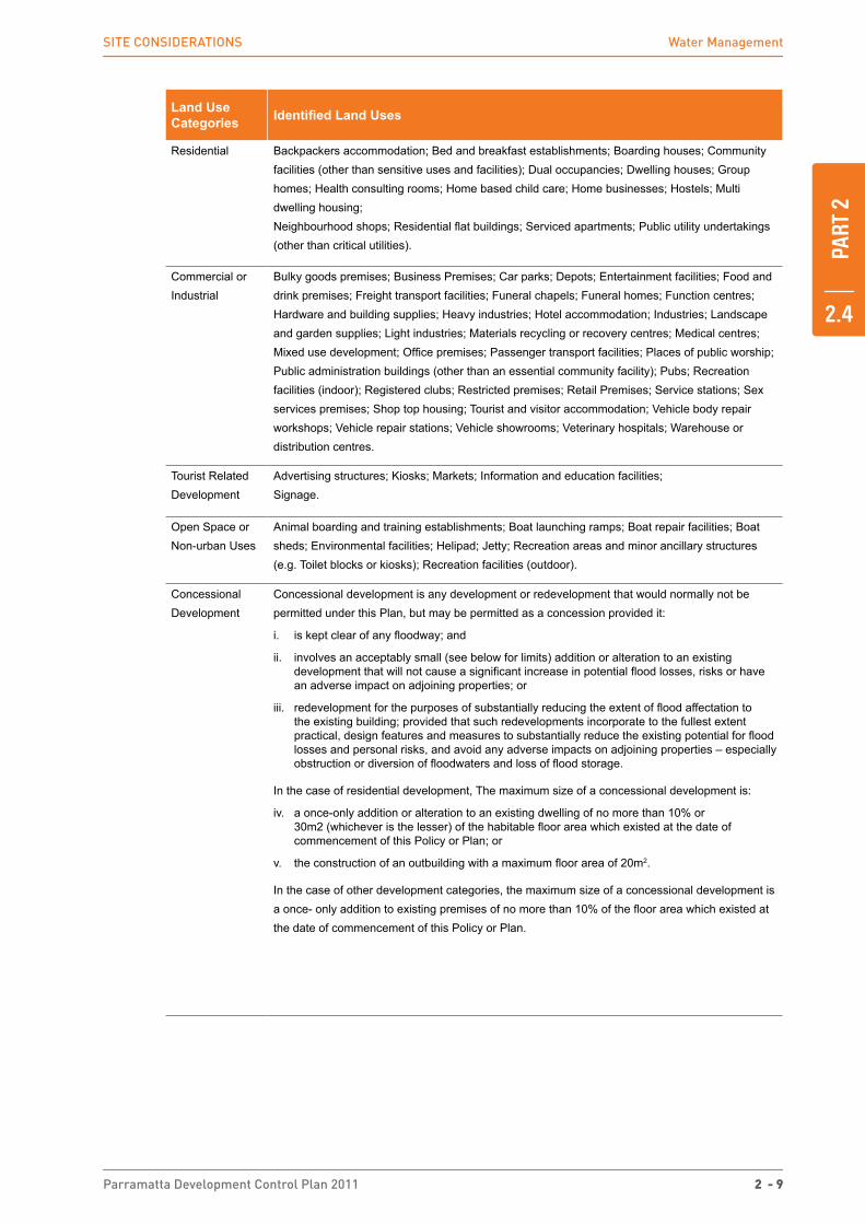
Table 2.4.2.1.1 Land Use Category Definitions
NOTE: Refer to the Parramatta LEP 2011 for definitions of each land use.
Land Use Categories Identified Land Uses
Sensitive Uses and Facilities
Community facilities or Public administration buildings which may provide an important contribution to the notification and evacuation of the community during flood events; Child care centres; Hospitals; Residential care facilities; Seniors housing; Educational establishments.
Critical Utilities and Uses
Hazardous industries; Hazardous storage establishments; Offensive industries; Offensive storage establishments; Liquid fuel depots; Public utility undertakings which may cause pollution of waterways during flooding, are essential to evacuation during periods of flood or if affected during flood events would unreasonably affect the ability of the community to return to normal activities afte flood events; Telecommunication facilities; Waste management facilities.
Subdivisions Subdivision of land which involves the creation of additional allotments.
Filling The net importation of fill material onto a site, except where:
i. final surface levels are raised by no more than 100mm over no more than 50% of the site; or
ii. filling is no more than 800mm thick beneath a concrete building slab only.
Compensatory earthworks, involving cut and fill, is not considered to be filling provided that:
i. there is no net importation of fill material onto the site; and
ii. there is no net loss of flood storage at all flood levels.
PART
2
2.4
Parramatta Development Control Plan 2011 2 - 9
SitE CoNSiDErAtioNS Water management
Land Use Categories Identified Land Uses
Residential Backpackers accommodation; Bed and breakfast establishments; Boarding houses; Community facilities (other than sensitive uses and facilities); Dual occupancies; Dwelling houses; Group homes; Health consulting rooms; Home based child care; Home businesses; Hostels; Multi dwelling housing; Neighbourhood shops; Residential flat buildings; Serviced apartments; Public utility undertakings (other than critical utilities).
Commercial or Industrial
Bulky goods premises; Business Premises; Car parks; Depots; Entertainment facilities; Food and drink premises; Freight transport facilities; Funeral chapels; Funeral homes; Function centres; Hardware and building supplies; Heavy industries; Hotel accommodation; Industries; Landscape and garden supplies; Light industries; Materials recycling or recovery centres; Medical centres; Mixed use development; Office premises; Passenger transport facilities; Places of public worship; Public administration buildings (other than an essential community facility); Pubs; Recreation facilities (indoor); Registered clubs; Restricted premises; Retail Premises; Service stations; Sex services premises; Shop top housing; Tourist and visitor accommodation; Vehicle body repair workshops; Vehicle repair stations; Vehicle showrooms; Veterinary hospitals; Warehouse or distribution centres.
Tourist Related Development
Advertising structures; Kiosks; Markets; Information and education facilities; Signage.
Open Space or Non-urban Uses
Animal boarding and training establishments; Boat launching ramps; Boat repair facilities; Boat sheds; Environmental facilities; Helipad; Jetty; Recreation areas and minor ancillary structures (e.g. Toilet blocks or kiosks); Recreation facilities (outdoor).
Concessional Development
Concessional development is any development or redevelopment that would normally not be permitted under this Plan, but may be permitted as a concession provided it:
i. is kept clear of any floodway; and
ii. involves an acceptably small (see below for limits) addition or alteration to an existing development that will not cause a significant increase in potential flood losses, risks or have an adverse impact on adjoining properties; or
iii. redevelopment for the purposes of substantially reducing the extent of flood affectation to the existing building; provided that such redevelopments incorporate to the fullest extent practical, design features and measures to substantially reduce the existing potential for flood losses and personal risks, and avoid any adverse impacts on adjoining properties – especially obstruction or diversion of floodwaters and loss of flood storage.
In the case of residential development, The maximum size of a concessional development is:
iv. a once-only addition or alteration to an existing dwelling of no more than 10% or 30m2 (whichever is the lesser) of the habitable floor area which existed at the date of commencement of this Policy or Plan; or
v. the construction of an outbuilding with a maximum floor area of 20m2.
In the case of other development categories, the maximum size of a concessional development is a once- only addition to existing premises of no more than 10% of the floor area which existed at the date of commencement of this Policy or Plan.

PART
2
2.4
2 - 10 Parramatta Development Control Plan 2011
SitE CoNSiDErAtioNS Water management
Table 2.4.2.1.2 Flood Plain Matrix Planning and Development Controls
Floo
d R
isk
Pre
cinc
ts
(FR
P’s
)Planning Consideration
Floo
r Lev
el
Bui
ldin
g C
ompo
nent
sS
truct
ural
S
ound
ness
Floo
d A
ffect
atio
n
Car
Par
king
&
Driv
eway
Acc
ess
Eva
cuat
ion
Man
agem
ent
& D
esig
n
Hig
h Fl
ood
Ris
k
Concessional Development 4, 5 1 1 1 1, 5 3, 4, 6 2, 3, 4Open Space & Non-Urban 1, 5 1 1 1 2, 4, 6, 7 1, 4 2, 3, 4Tourist Related Development X X X X X X XCommercial & Industrial X X X X X X XResidential* X X X X X X XFilling X X X X X X XSubdivision X X X X X X XCritical Uses & Facilities X X X X X X XSensitive Uses & Facilities X X X X X X X
Med
ium
Flo
od R
isk
Concessional Development 4, 5 1 1 1 1, 5 3, 6 2, 3, 4
Open Space & Non-Urban 1, 5 1 1 2 2, 4, 6, 7 1, 4 2, 3, 4Tourist Related Development 2, 5 1 1 1 1, 3, 5, 6, 7 3, 4, 6 2, 3, 4Commercial & Industrial 2, 5 1 1 1 1, 3, 5, 6, 7 3, 4, 6 2, 3, 4Residential* 2, 5 1 1 1 1, 3, 5, 6, 7 3, 4, 6 2, 3, 4
Filling X X X X X X XSubdivision 1 5, 3, 4 1Critical Uses & Facilities X X X X X X XSensitive Uses & Facilities X X X X X X X
Low
Flo
od R
isk
Concessional DevelopmentOpen Space & Non-Urban 2, 4, 6, 7Tourist Related Development 2, 5 2 1, 3, 5, 6 4Commercial & Industrial 2, 5 2 1, 3, 5, 6 4Residential* 2, 5 2 1, 3, 5, 6 3, 4Filling 1Subdivision 2 5 1Critical Uses & Facilities 3 2 2 2 1, 3, 5, 6 2, 4, 6 2, 3, 4Sensitive Uses & Facilities X X X X X X X
*for redevelopment of existing dwellings refer also to ‘Concessional Development Provisions”Legend
Not Relevant X Unsuitable Land Use
i. Freeboard equals an additional height of 500mm.
ii. The Parramatta LEP 2011 identifies development permissible with consent in various zones. Notwithstanding, constraints specific to individual sites may preclude Council granting consent for certain forms of development on all or part of a site. The above matrix identifies where flood risks are likely to determine where certain development types will be considered “unsuitable” due to flood related risks.
iii. Filling of the site, where acceptable to Council, may change the FRP considered to determine the controls applied in the circumstances of individual applications.
iv. Any fencing that forms part of a proposed development is subject to the relevant Flood Effects and Structural Soundness planning considerations of the applicable land use category.
v. Development within the floodplain may be subject to Clause 6.7 Foreshore Building Line in the Parramatta LEP 2011.
PART
2
2.4
Parramatta Development Control Plan 2011 2 - 11
SitE CoNSiDErAtioNS Water management
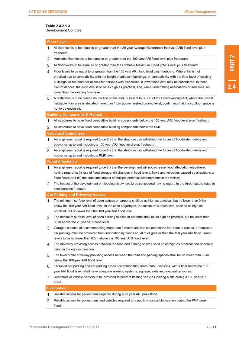
Table 2.4.2.1.3 Development Controls
Floor Level
1 All floor levels to be equal to or greater than the 20 year Average Recurrence Interval (ARI) flood level plus freeboard.
2 Habitable floor levels to be equal to or greater than the 100 year ARI flood level plus freeboard.
3 All floor levels to be equal to or greater than the Probable Maximum Flood (PMF) level plus freeboard.
4 Floor levels to be equal to or greater than the 100 year ARI flood level plus freeboard. Where this is not practical due to compatibility with the height of adjacent buildings, or compatibility with the floor level of existing buildings, or the need for access for persons with disabilities, a lower floor level may be considered. In these circumstances, the floor level is to be as high as practical, and, when undertaking alternations or additions, no lower than the existing floor level.
5 A restriction is to be placed on the title of the land, pursuant to S.88B of the Conveyancing Act, where the lowest habitable floor area is elevated more than 1.5m above finished ground level, confirming that the subfloor space is not to be enclosed.
Building Components & Method
1 All structures to have flood compatible building components below the 100 year ARI flood level plus freeboard.
2 All structures to have flood compatible building components below the PMF.
Structural Soundness
1 An engineers report is required to certify that the structure can withstand the forces of floodwater, debris and buoyancy up to and including a 100 year ARI flood level plus freeboard.
2 An engineers report is required to certify that the structure can withstand the forces of floodwater, debris and buoyancy up to and including a PMF level.
Flood Affectation
1 An engineers report is required to certify that the development will not increase flood affectation eleswhere, having regard to: (i) loss of flood storage; (ii) changes in flood levels, flows and velocities caused by alterations to flood flows; and (iii) the cumulate impact of multiple potential developments in the vicinity.
2 The impact of the development on flooding elsewhere to be considered having regard to the three factors listed in consideration 1 above.
Car Parking and Driveway Access
1 The minimum surface level of open spaces or carports shall be as high as practical, but no lower than 0.1m below the 100 year ARI flood level. In the case of garages, the minimum surface level shall be as high as practical, but no lower than the 100 year ARI flood level.
2 The minimum surface level of open parking spaces or carports shall be as high as practical, but no lower than 0.3m above the 20 year ARI flood level.
3 Garages capable of accommodating more than 3 motor vehicles on land zones for urban purposes, or enclosed car parking, must be protected from inundation by floods equal to or greater than the 100 year ARI flood. Ramp levels to be no lower than 0.5m above the 100 year ARI flood level.
4 The driveway providing access between the road and parking spaces shall be as high as practical and generally rising in the egress direction.
5 The level of the driveway providing access between the road and parking spaces shall be no lower than 0.2m below the 100 year ARI flood level.
6 Enclosed car parking and car parking areas accommodating more than 3 vehicles, with a floor below the 100 year ARI flood level, shall have adequate warning systems, signage, exits and evacuation routes.
7 Restraints or vehicle barriers to be provided to prevent floating vehicles leaving a site during a 100 year ARI flood.
Evacuation
1 Reliable access for pedestrians required during a 20 year ARI peak flood.
2 Reliable access for pedestrians and vehicles required to a publicly accessible location during the PMF peak flood.

PART
2
2.4
2 - 12 Parramatta Development Control Plan 2011
SitE CoNSiDErAtioNS Water management
3 Reliable access for pedestrians and vehicles is required from the site to an area of refuge above the PMF level, either on site (eg. second storey) or off site.
4 Applicant is to demonstrate the development is consistent with any relevant flood evacuation strategy or similar plan.
5 Applicant is to demonstrate that evacuation in accordance with the requirements of this DCP is available for the potential development resulting from the subdivision.
6 Adequate flood warning is available to allow safe and orderly evacuation without increased reliance upon SES or other authorised emergency services personnel.
Management and Design
1 Applicant is to demonstrate that potential development as a consequence of a subdivision proposal can be undertaken in accordance with this the relevant FRMS and FRMP
2 Site Emergency Response Flood plan required where the site is affected by the 100 year ARI flood level, (except for single dwelling-houses).
3 Applicant is to demonstrate that area is available to store goods above the 100 year flood level plus freeboard.
4 No storage of materials below the 100 year ARI flood level.
Further Information
Flood Risk Management Plan, Flood Studies, Sub-Catchment Management Plans and Local Floodplain Risk Management Policy available from the City of Parramatta Council.
NSW Government’s Floodplain Development Manual 2005 – www.dnr.nsw.gov.au/floodplains/manual.shtml
City of Parramatta Council’s Local Floodplain Risk Management Policy, 2006.
2.4.2.2 Protection of Waterways
Objective
O.1 To ensure development contributes to the protection and rehabilitation of waterways in order to improve waterway health and to develop and maintain ecologically sustainable waterways.
Design Principles
P.1 Development is to make provision for buffer areas for the preservation and maintenance of floodway, riparian corridors and habitat protection. Refer to Clause 6.7 Foreshore Building Line and Clause 6.5 Water Protection in the Parramatta LEP 2011.
P.2 Development on land subject to Clause 6.5 Water Protection in the Parramatta LEP 2011 or that abuts a waterway is to be landscaped with local indigenous species, to protect bushland and wildlife corridors and soften the nterface between the natural landscape and the urban environment. Riparian vegetation also plays an important role in stabilising bed and banks and attenuating flood flows.
P.3 The piping, enclosing or artificial channelling of natural watercourses and drainage channels is not permitted. Consideration is to be given to re-opening piped or lined drainage systems wherever feasible.
P.4 Development is to ensure that natural channel design principles are incorporated in any works on or in waterways. Refer to Figure 2.8.
P.5 Ongoing maintenance costs are to be considered in the design of any waterway protection features.
Further Information
Brisbane City Council 2000, Natural Channel Design Guidelines
PART
2
2.4
Parramatta Development Control Plan 2011 2 - 13
SitE CoNSiDErAtioNS Soil management
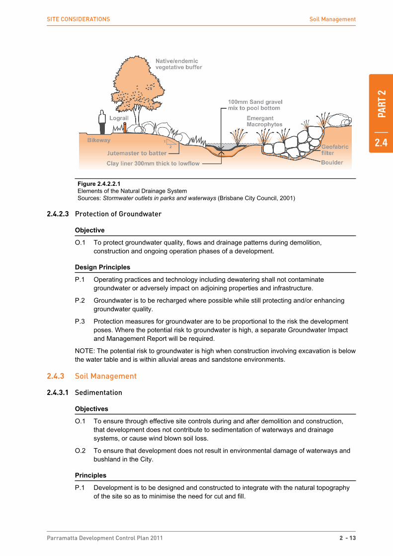
Figure 2.4.2.2.1 Elements of the Natural Drainage SystemSources: Stormwater outlets in parks and waterways (Brisbane City Council, 2001)
2.4.2.3 Protection of Groundwater
Objective
O.1 To protect groundwater quality, flows and drainage patterns during demolition, construction and ongoing operation phases of a development.
Design Principles
P.1 Operating practices and technology including dewatering shall not contaminate groundwater or adversely impact on adjoining properties and infrastructure.
P.2 Groundwater is to be recharged where possible while still protecting and/or enhancing groundwater quality.
P.3 Protection measures for groundwater are to be proportional to the risk the development poses. Where the potential risk to groundwater is high, a separate Groundwater Impact and Management Report will be required.
NOTE: The potential risk to groundwater is high when construction involving excavation is below the water table and is within alluvial areas and sandstone environments.
2.4.3 Soil management
2.4.3.1 Sedimentation
Objectives
O.1 To ensure through effective site controls during and after demolition and construction, that development does not contribute to sedimentation of waterways and drainage systems, or cause wind blown soil loss.
O.2 To ensure that development does not result in environmental damage of waterways and bushland in the City.
Principles
P.1 Development is to be designed and constructed to integrate with the natural topography of the site so as to minimise the need for cut and fill.

PART
2
2.4
2 - 14 Parramatta Development Control Plan 2011
SitE CoNSiDErAtioNS Soil management
P.2 Soil loss from development is to be minimised through effective site management practices that reduce the impact of sedimentation on downstream waterways and drainage systems and that minimise wind blown soil loss.
P.3 Development is to minimise site disturbance, including impact on vegetation and significant trees.
P.4 Development that is likely to result in erosion and sedimentation is to be accompanied by details of the proposed method of on-site erosion and sediment control. Such details are to follow the guidelines in the NSW Landcom (2004) Managing Urban Stormwater: Soils and Construction and Council’s Design and Development Guidelines.
Figure 2.4.3.1.1 Stabilised Site AccessSource: Soils and Construction: Managing Urban Stormwater, Landcom, March 2004.
Figure 2.4.3.1.2 Sedimentation fencingSources: Soils and Construction: Managing Urban Stormwater, Landcom, March 2004

PART
2
2.4
Parramatta Development Control Plan 2011 2 - 15
SitE CoNSiDErAtioNS Soil management
Figure 2.4.3.1.3 Section - Sedimentation fencingSources: Soils and Construction: Managing Urban Stormwater, Landcom, March 2004
Figure 2.4.3.1.4 Plan - Sedimentation fencingSources: Soils and Construction: Managing Urban Stormwater, Landcom, March 2004
2.4.3.2 Acid Sulfate Soils
Objective
O.1 To ensure the environmental value and ecological health of waterways are protected from the release of acid water from exposed acid sulfate soils.
Design Principle
P.1 Development is to ensure that sites with potential to contain acid sulfate soils are managed in a manner consistent with the provisions contained in the Parramatta LEP 2011.
PART
2
2.4
2 - 16 Parramatta Development Control Plan 2011
SitE CoNSiDErAtioNS land Contamination
2.4.3.3 Salinity
Objectives
O.1 To ensure that soil or groundwater salinity does not impact on the structural integrity of a development.
O.2 To control the impact of the development on prevailing and potential soil or groundwater salinity in the City.
Design Principles
P.1 Construction techniques are to be employed that prevent structural damage to the development as a result of salinity. Where the potential risk of salinity is identified by using the Salinity Study Map for Western Sydney 2006, further investigations in accordance with the Western Sydney Salinity Code of Practice 2003 are to be undertaken.
P.2 Protection measures to mitigate the impact of the development on soil salinity are to be employed.
Further Information
Sydney Metropolitan Catchment Management Authority 2006, Salinity Study Map for Western Sydney
Western Sydney Regional Organisation of Councils 2003, Western Sydney Salinity Code of Practice
2.4.4 land Contamination
‘Contaminated land’ has the same meaning as in the Environmental Planning and Assessment Act 1979. The term is defined as follows:
Contaminated land means land in, on or under which any substance is present at a concentration above the concentration at which the substance is normally present in, on or under (respectively) land in the same locality, being a presence that presents a risk of harm to human health or any other aspect of the environment.
Land contamination is most often the result of past uses. It can occur as a result of poor environmental management and waste disposal practices or accidental spills in industrial or commercial activities. The poor planning and management of contaminated land can present a risk to public health and the environment.
Development proposals for land that is or has previously been used for a purpose which is likely to have contaminated the site must address the requirements of State Environmental Planning Policy (SEPP) No. 55 - Remediation of Land. References are made to this SEPP in the following provisions and should be referred to for further information and clarification.
Objectives
O.1 Ensure that changes of land use will not increase the risk to public health or the environment.
O.2 Ensure that any redevelopment of land for sensitive uses considers the potential contamination of the land.
O.3 Avoid inappropriate restrictions on land that could otherwise be remediated.
O.4 Consider the likelihood of land contamination as early as possible in the planning process.
O.5 Link decisions about the development of land with the information available about contamination.

PART
2
2.4
Parramatta Development Control Plan 2011 2 - 17
SitE CoNSiDErAtioNS land Contamination
Design Principles
Development applications
P.1 Prior to the submission of a development application an assessment is to be made by the applicant under Clause 7 of SEPP No. 55 as to whether the subject land is contaminated.
Note: The following guidelines prepared by NSW Environmental Protection Authority, where relevant, must be used in preparing preliminary assessments and all levels of contaminated site reports:
� Contaminated Sites: Sampling Design Guidelines, 1995b
� Contaminated Sites: Guidelines for Consultants Reporting on Contaminated Sites, 1997a
� Contaminated Sites: Guidelines for Assessing Service Station Sites, 1994
� Contaminated Sites: Guidelines for the NSW Site Auditor Scheme, 1998
P.2 Council under Clause 7 (1) of SEPP No. 55 must not consent to development unless it has considered whether land is contaminated, and if the land is contaminated is suitable for the proposed purpose or is satisfied that the land will be appropriately remediated. Where land is proposed to be subject to remediation, adequate documentation is to be submitted to Council supporting the categorisation.
Development consent for remediation work
P.3 Development consent is required for remediation work in sensitive areas (Category 1 remediation works) under Clause 8 (2) of SEPP No. 55.
P.4 Development consent is not required for other remediation work (Category 2 remediation work) under Clause 8 (2) of SEPP No. 55. However, under Section 16 of the SEPP, notice is required to be given of the proposed work to Council before commencement of works.
Activities that may cause Contamination
Some activities that are likely to cause land contamination are shown in Table 2.8 - for further information, refer to the Managing Land Contamination Planning Guidelines, Department of Urban Affairs and Planning and EPA, 1998.
Table 2.4.4.1 Some Activities that may cause Contamination
Some Activities that may cause Contamination
� acid/alkali plant and formulation � agricultural/horticultural activities � airports � asbestos production and disposal � chemicals manufacture and formulation � defence works � drum re-conditioning works � dry cleaning establishments � electrical manufacturing (transformers) � electroplating and heat treatment premises � engine works � explosives industry � gas works � iron and steel works
� metal treatment � mining and extractive industries � oil production and storage � paint formulation and manufacture � pesticide manufacture and formulation � power stations � railway yards � scrap yards � service stations � sheep and cattle dips � smelting and refining � tanning and associated trades � waste storage and treatment � wood preservation
PART
2
2.4
2 - 18 Parramatta Development Control Plan 2011
SitE CoNSiDErAtioNS Air quality
Source: ANZECC and NHMRC 1992, The Australian and New Zealand Guidelines for the Assessment and Management of Contaminated Sites.
NOTE: It is not sufficient to rely solely on the contents of this Table to determine whether a site is likely to be contaminated or not. The Table is a guide only. A conclusive status can only be determined after a review of the site history and, if necessary, sampling.
Further Information
Contaminated Land Management Act 1997
Contaminated Land Management Regulation 2008
Department of Planning website: www.planning.nsw.gov.au
Managing Land Contamination: Planning Guidelines, 1998, Department of Urban Affairs and Planning and Environment Protection Authority.
2.4.5 Air quality
Objective
O.1 To protect air quality and enhance environmental amenity.
Design Principles
P.1 Development that is likely to result in the emission of atmospheric pollutants, including odours, is to include operating practices and technology to ensure that the development does not contribute to increased air pollution.
P.2 Effective site controls during and after demolition and construction are to ensure that development does not contribute to increased air pollution.
NOTE: Discharges from premises of any matter, whether solid, liquid or gaseous is required to conform to the Protection of the Environment Operations Act and its Regulations, or a pollution control approval issued by the NSW Office of Environment and Heritage for Scheduled Premises.
2.4.6 Development on Sloping land
Objectives
O.1 To protect and minimise disturbance to natural landforms.
O.2 To encourage buildings that are designed to respond sensitively to natural topography.
Design Principle
P.1 Buildings are to be sited and designed to take into account the slope of the land to:
� minimise the visual bulk of the development, particularly when viewed from down slope
� minimise the need for cut and fill by designs which minimise the building footprint and allow the building mass to step down the slope
� minimise the impact of development on the privacy of adjoining land.

PART
2
2.4
Parramatta Development Control Plan 2011 2 - 19
SitE CoNSiDErAtioNS biodiversity
Figure 2.4.6.1 Development on sloping land
2.4.7 biodiversity
The Parramatta LGA currently contains 412ha of bushland including several examples of endangered ecological communities and vulnerable or endangered flora and fauna species under the Threatened Species Conservation Act 1995. There are also significant specimens of indigenous, native and cultural trees present in the public domain and on private property that contribute to Parramatta’s biodiversity.
Parramatta is a City that values, protects and conserves its locally occurring native plants, animals and other living things, the environment they live in and the way they interact, so that biodiversity is sustained and enhanced.
Objectives
O.1 To minimise the impact of development on the City’s biodiversity by:
� minimising the removal of indigenous vegetation and naturally occurring soils;
� conserving existing significant indigenous and native trees; and
� encouraging planting of indigenous and native plants and trees on private property.
O.2 Retention and protection of areas of existing biodiversity value, particularly key vegetation links and fauna corridors.
2.4.7.1 General
Design Principles
P.1 Development is to be sited and designed to minimise the impact on indigenous flora and fauna, including canopy trees and understorey vegetation, and on remnant native ground cover species.
P.2 Preference is to be given to the planting of species indigenous to the vegetation community of the local area. Refer to Appendix 3 Vegetation Communities and Remnant Trees for listing of appropriate species.
P.3 Development is to be sited and designed to minimise the impact on cultural trees and plantings and consideration is to be given to further planting of cultural trees and landscaping where appropriate.
PART
2
2.4
2 - 20 Parramatta Development Control Plan 2011
SitE CoNSiDErAtioNS Public Domain
P.4 Council will require the submission of a Statement of Flora/Fauna Impact (SFFI) for all development in or adjacent to bushland with respect to the impact on biodiversity. Development in or adjacent to bushland is to have regard to the impact on biodiversity.
P.5 Where a SFFI identifies species, populations or ecological communities listed under Schedules 1 and 2 of the Threatened Species Conservation Act 1995, Section 5A of the Environmental Planning and Assessment Act 1979 applies, and an “Assessment of Significance” must be prepared and submitted to Council in addition to the SFFI.
P.6 Preference is to be given to landscaping elements that provide/promote faunal habitat, eg. natural rock, dry walling and frog ponds.
P.7 Pruning or removal of trees must be in accordance with Section 5.4 Preservation of Trees or Vegetation of this DCP.
P.8 Consideration must be given to the impacts of climate change on flora and fauna species and their habitat.
P.9 Consideration must be given to the impacts of lighting on flora and fauna species and their habitat.
2.4.7.2 Development on land abutting the E2 Environmental Protection zone and W1 Natural Waterways zone
Design Principle
P.1 Development on land abutting land within the E2 Environmental Protection zone and W1 Natural Waterways zone must take into consideration all of the following:
� the need to retain any bushland on the land;
� the effect of the proposed development on bushland, including the erosion of soils, the siltation of streams and waterways and the spread of weeds and exotic plants within the bushland, overshadowing, overland flows and stormwater runoff, and the removal or degradation of existing vegetation;
� the requirement for provision of a buffer zone on the abutting land to protect the bushland area;
� the protection of endangered ecological communities and recovery plans prepared and approved under the Threatened Species Conservation Act 1995; and
� any other matters which are relevant to the protection and preservation of the bushland area.
Further Information
Environmental Planning and Assessment Act 1979 (Section 5A)
Environment Protection and Biodiversity Conservation Act 1999 (Cth.)
Parramatta Planting Strategy, City of Parramatta Council, 2002
Parramatta Biodiversity Plan Review, City of Parramatta Council, 2008
State Environmental Planning Policy No. 19 - Bushland in Urban Areas
State Environmental Planning Policy No. 44 - Koala Habitat Protection
Threatened Species Conservation Act 1995
2.4.8 Public Domain
The public domain comprises the publically accessible streets, parks and squares, the structures that relate to those spaces and the infrastructure that supports and serves them. Parramatta’s public domain includes the railway corridors, streetscapes, public car parks, parks

PART
2
2.4
Parramatta Development Control Plan 2011 2 - 21
SitE CoNSiDErAtioNS Public Domain
and reserves and natural waterways. The public domain incorporates elements such as fences, bridges, trees, footpaths, street furniture and artworks. Development of private property should have regard and make a positive contribution to the interface with the public domain.
Objectives
O.1 To enhance the quality of the public domain.
O.2 To ensure the public domain is attractive, safe, interesting, comfortable, readily understood and easily accessed.
O.3 To ensure that development adjacent to public domain elements such as waterways, streets, parks, bushland reserves and other public open spaces, complements the landscape character, public use and enjoyment of that land.
Design Principles
P.1 Development is to be designed to address elements of the public domain, including the building interface between private and public domains, circulation patterns and accessways, gateways, nodes, edges, landscape features, heritage items, ground floor activity and built form definition to the street.
P.2 Public access to the public domain is to be maximised.
P.3 Buildings are to be located to provide an outlook to the public domain, without appearing to privatise that space.
P.4 Development is to provide passive surveillance to the public domain. Continuous lengths of blank walls and fences at the public domain interface are to be avoided.
P.5 Where appropriate, ground floor areas abutting public space should be occupied by uses that create active building fronts with pedestrian flow, and contribute to the life of the streets and other public spaces.
P.6 Development is to be designed in accordance with Council’s current public domain guidelines.
P.7 New development is encouraged to provide public domain improvements. Applicants should consult with Council to determine the appropriate public domain treatment suitable for the site and surrounds. This may include street tree planting, street paving, street furniture and public artwork.
NOTE: In certain areas, public domain improvements are required by Council. Please contact Council for more information.

THIS PAGE HAS BEEN INTENTIONALLY LEFT BLANK