PAN OCEAN OIL LTD. JOINT VENTURE PRELIMINARY GEOLOGICAL ...
23
MOUNTAINEER MINES LTD. - PAN OCEAN OIL LTD. JOINT VENTURE PRELIMINARY GEOLOGICAL REPORT on the OWL 1-20 MINERAL CLAIMS N.T.S. 106-E-2 65O13'~ 134~44'~ YUKON TERRITORY . M. A. STAMMERS a- Geologist x C. K. IKONA - P.Eng. November, 1977 Pamicon Developments Ltd. - .
Transcript of PAN OCEAN OIL LTD. JOINT VENTURE PRELIMINARY GEOLOGICAL ...

MOUNTAINEER MINES LTD. - PAN OCEAN OIL LTD. JOINT VENTURE
PRELIMINARY GEOLOGICAL REPORT
on the
OWL 1-20 MINERAL CLAIMS
N.T.S. 106-E-2
65O13'~ 1 3 4 ~ 4 4 ' ~
YUKON TERRITORY
. M. A. STAMMERS a- Geologist
x C. K. IKONA - P.Eng.
November, 1977
Pamicon Developments Ltd. - .

- nparrt bar B;rp th* ~ b g k z d F$s&rt.&hi~1~ &i# cm%IFaQ! $8 i%w. meadd to @JI% &ma$: -2 ::-i z to kq . % \,$. -
C:ruai~%rctt! as r\ gremataaian wwk usdw uwtz Miniag At&,

TABLE OF CONTENTS .
Page
.................................... 1.0 INTRODUCTION 1 .
.................................. 2.0 LIST OF CLAIMS 1
............................. 3.0 LOCATION AND ACCESS 1
..... . Figure 1 Property Location Map after page 1
. ................. Figure 2 Claim Map after page 1
....................... 4.0 TOPOGRAPHY AND VEGETATION 2
5.0 REGIONAL GEOLOGY ................................ 2 6.0 PROPERTY GEOLOGY
.................................. 6.1 Introduction 5
..................................... 6.2 Lithology 5
.................... 6.3 Structure and Stratigraphy 6
................................ 6.4 Mineralization 7
. ............... Figure 3 Geology Map after page 7
. .......... Figure 4 Geochemistry Map after page 7
.................................... 7.0 GEOCHEMISTRY 7
.......... . Table 7.1 Water Geochemistry Results 8
..... . Table 7.2 Stream Silt Geochemistry Results 9
...................... 8.0 DISCUSSION AND CONCLUSIONS 11
................................. 9.0 RECOMMENDATIONS 12
LIST OF APPENDICES
---X I . t . . c. -Y
APPENDIX I1 - Assay Procedures
- ; 9 s = - I , ~ APPENDIX VI - Certificates of Analysis
Pamicon Developments Ltd .

1 . 0 INTRODUCTION
The OWL 1-20 mine ra l c l a imswere s t a k e d on Nbvember 29,
1976 by Pamicon ~ e v e l o p m e n t s ' L t d . f o r Pan Ocean O i l L td . The
c la ims were s t a k e d t o cover a uranium water geochemist ry
anomaly based on d a t a r e l e a s e d by t h e Geologica l Survey o f
Canada.
During t h e p e r i o d s June 4 t o 9, 1977 and June 26 t o
J u l y 4 , 1977 g e o l o g i c e v a l u a t i o n and d e t a i l e d p r o s p e c t i n g
was c a r r i e d o u t i n t h e c la ims a r e a by Pamicon Developments Ltd
under t h e f i e l d s u p e r v i s i o n of R. Darney.
2.0 LIST OF CLAIMS
CLAIM NAME - RECORDING DATE STAKING DATE GRANT NUMBERS
OWL 1-20 December 17/76 November 29/76 YA14823-YA1984: i n c l .
Claim p o s t s examined by t h e a u t h o r appear t o conform
wi th t h e Yukon Q u a r t z Mining Act r e g u l a t i o n s .
3.0 LOCATION AND ACCESS -
The OWL group, i s l o c a t e d 2 m i l e s w e s t of K i w i Lake i n
t h e n o r t h e a s t e r n Yukon T e r r i t o r y . The p r o p e r t y i s 115 m i l e s
no r th -no r theas t o f Mayo, Y.T. Approximate co -o rd ina t e s
of t h e c l a im group a r e 6 5 O 1 3 ' ~ and 1 3 4 ~ 4 4 ' ~ .
Access t o t h e p r o p e r t y i s recommended by f loa t - equ ipped
a i r c r a f t from Mayo t o K i w i Lake and h e l i c o p t e r from t h e r e
t o t h e p r o p e r t y . Both h e l i c o p t e r and f i x e d wing a i r c r a f t
a s w e l l as f u l l e x p e d i t i n g s e r v i c e s a r e a v a i l a b l e i n Mayo.
A Pamicon Developments Ltd.


OWL 1-20 CLAIM GROUP

- 2 -
4.0 TOPOGRAPHY AND VEGETATION - Eleva t ions on t h e p r o p e r t y range from 2,200 t o 4,200
f e e t and topography ranges from moderate t o rugged. Most
ou t c rops a r e r e s t r i c t e d t o r i d g e s and t o s t r eam channe ls .
The t r e e l i n e l i e s a t approximately 3,500 f e e t and sp ruce ,
wi l low and a l d e r a r e found a t lower e l e v a t i o n s wh i l e low
g r a s s e s and c a r i b o u moss cover h i g h e r t e r r a i n .
5 . 0 REGIONAL GEOLOGY
The Q u a r t e t - F a i r c h i l d r e g i o n l i e s i n t h e Wernecke
Mountains of t h e n o r t h e a s t e r n Yukon T e r r i t o r y . I n t h e
g e n e r a l a r e a , t h e Werneckes c o n s i s t o f l o c a l ranges which
i n c l u d e t h e Rackla Range, Bonnet Plume Range and Knorr
Range. Topography i s normal ly m o d e r a t e - t o rugged wi th
e l e v a t i o n s ranging from 2,000 t o 6,500 f e e t . The major r i v e r
v a l l e y s a r e broad, t imbered and e x t e n s i v e l y overburden covered,
wh i l e most mountain s l o p e s p r e s e n t g r e a t e r t h a n 60% ou tc rop
above t h e 4,000 f o o t l e v e l .
The e n t i r e a r e a has been mapped by t h e Geologica l Survey
of Canada and t h r e e s e p a r a t e p u b l i c a t i o n s a r e p re sen ted .
The fo l lowing memoir and open f i l e r e p o r t s g i v e 1" = 4 m i l e s
g e o l o g i c a l coverage of t h e Nash Creek, Nadaleen River , Wind
River and Snake River map a r e a s .
(1) Geology of Nash Creek, Larsen Creek and Dawson
Map-Area, Yukon T e r r i t o r y by L.H. Green 1972 (Memoir 364) .
Pamicon Developments Ltd. -

- 3 - (2) Open File 205 (Geology of Nadaleen River and Bonnet Plume
Lake Map sheets by S. Blusson) 1975.
( 3 ) Open File 279 (Geology of Snake River and Wind River
sheets by D.K. Norris) 1975.
In the Quartet-Fairchild-Gillespie Lakes region Helikian
rocks are exposed over an area of some 1,500 sq. miles in a
roughly circular fashion centered near Longitude 134O00~ and
Latitude 65°00vN.
These rocks have been described as Units 1 & 2 by
L. Green on the Nash Creek Sheet.
Recent G.S.C. stratigraphic work by Bell and Delaney
(1976) has redesignated Units la, 1 and 2 (Green 1972) as
Units A, B, and C respectively. The unit designations as
established by Bell and Delaney will be used in this report.
Unit A whose base is not exposed, is composed of a
thick succession of moderately metamorphosed fine grained
clastic sediments with interbedded carbonates. The overlying
Unit B consists of thinly interbedded slates and argillites
with occasional quartzite beds.
Unit C, which conformably overlies the uppermost slate-
quartzite section of Unit B, consists mainly of thickly
bedded orange weathering dolomites. The base of the .unit
i s marked by a series of transitional beds of alternating
buff weathering dolomites and interbedded slates and quartzites.
Erratically di.s-trfh~~eed throughout the Proterozoic
metasediments are irregularly shaped breccia bodies. The
4 ...
I Pamicon Developments Ltd. -

- 4 -
breccia zones vary from tens of feet to several thousand
feet in size and appear as cross cutting pipe-like features
at all levels in the stratigraphic column. Several varieties
exist, but all exhibit an assortment of angular clasts
derived from rock types common to the area. Hornfels margins
observed at several localities indicate an intrusive origin.
A common association with many of the breccia bodies
are zones of veining or locally pervasive feldspar alteration
seen as internal features within the breccias or in host
rocks adjacent to them.
The alteration zones are pink in colour due to either
K-spar or strong hematization and in some instances contain
varying amounts of specularite, chalcopyrite and minor
uranium mineralization.
5.1 Structure
Two major periods of deformation have taken place within
the Wernecke Mountain region. During the first period or
Racklan Orogeny, the Proterozoic rocks of Units A, B , and C
underwent intense f~lding and faulting. Folds are tight to
isoclinal with the development of strong axial plane
cleavage and commonly an almost vertical foliation.
A major unconformity of Lower Hadrynian age forms the
upper contact of Unit C. In many localities, erosion
beneath this unconformity has resulted in the complete removal
of Unit C and the strong angular relationship between the
relatively flat lying Cambrian and younger rocks directly
overlying Units A and B is apparent.
5 ... 1 Pamicon Developments Ltd. -

- 5 -
Further unconformities near the Upper Hadrynian,
Lower Cambrian and Upper Cambrian margins leave Devonian
carbonates directly over the Helikian section.
The second period af deformation, which involves both
Paleozoic and Proterozoic strata, is weak compared to the
first. This is particularily evident in the younger
'carbonate sections to the west and southwest where deformation
consists mainly of broad open folding and minor overthrusting.
6.0 PROPERTY GEOLOGY
6.1 Introduction 7
The OWL 1-20 mineral claims cover- Unit A rocks of lower
Helikian age. Four lithologic sub-divisions have been
recognized. The area under study is variably metamorphosed,
faulted, folded and intruded by thick bull quartz veins.
See Figure 3 for the geology of the OWL claims area.
Geochemical analysis of stream silts demonstrated
anomalous values of U308. However, to date there were no
visible uranium occurrences found.
6.2 Lithology -
The banded quartzite, map Unit Al, is found exposed along
the southern perimeter of the OWL group property. The unit
locally contains silty or impure quartzites. Other minerals
present are chlorite and possibly pyrite. Banding is
exemplified by chlorite segregate layers and partings. The
base of the unit was not observed. Map Unit A2 consists of
6 ...
Pamicon Developments Ltd.

- 6 -
a quartz-chlorite schist which locally contains biotite and
muscovite. Although the schist normally exhibits strong
foliation and compositional banding, it often lacks a true
banded character and appears phyllitic.
Relict bedding is frequently identifiable. The schist
is green-grey, fine to medium-grained, weathers green grey and
grades upwards through a transition zone into a dark green
metasiltstone.
Themetasiltstones,map Unit A 3 , contains dark green rocks
at the base which become light green upwards through the
section. The unit is massively bedded, medium grained and
insipiently schistose,and composed mainly of quartz and
chlorite. Best exposures are found on the ridge located in
the eastern part of the property. Locally the unit is interbe
ded with quartzite.
Float samples found on the northeastern ridge on the
property lead to the selection of a fourth lithological
group. This preliminary map unit, A4, is described as a
medium to dark grey, finely crystalline and thinly bedded
silfstone/sandstone.
All four map units belong to regional Map Unit A of
Helikian age.
6.3 Structure and Stratigraphy
Stratigraphically the banded quartzite is the oldest map
unit exposed on the property and is overlain by the schist/
phyllite map unit. The dark green metasiltstone overlies
7 ... c Pamicon Developments Ltd.

I ~ l t s k m e / Sandstone
a Green Metas~lfstone
b n d e d Quartzite
Contact . ..--+ Fault - Schlstos~fy Attltude B e d d ~ n g A t t ~ t u d e
-- 4 -v 'ynform F ~ l d Axis A n t ~ f o r m
MOUNTAINEER-PAN OCEAN JOINT VENTURE
O'WL 1-20 MINERAL CLAIMS NTS 106-E2
PRELIMINARY GEOLOGY MAP Y U K O N T E R R I T O R Y
PAM ICO N DEVELOPMENTS UM ITED --
DRAWN:
A l t a l r I-

- 7 -
the schist/phyllite through a small transition zone, The
youngest lithology exposed on the property is the sandstone/
siltstone found in the northeast corner of the group,
Several small folds with an axial trend of 30° and a
gentle plunge to the southwest cross the property. Minor
faulting and associated bull quartz veining is found close
to the fold axes. -
Metamorphism of the silty and siliceous meta-sediments
has produced the banded quartzite and the schist/phyllite.
Relict compositional banding is generally well preserved in
the schist/phyllite unit. Metamorphic grade increases towards
the south.
A large northeast trending fault at the southeastern
perimeter of the property may be a factor in creating the
structure found on the group.
6.4 Mineralization
Despite a favourable geological and geochemical environment,
there were no discoveries of uranium or copper mineralization
during either visit,to the OWL 1-20 mineral claims. The
low amount of exposure limits visual prospecting techniques.
7.0 - GEOCHEMISTRY
During prospecting in the claims area five water
g~chemistr~samples were taken from active streams draining
the property. In addition,in 1976 the Geological Survey of
Canada took 20 samples from streams on the property. Samples
collected by Pamicon Developments Ltd. were placed in
8 ... Pamicon Developments Ltd. 2

I LEGEND
0 5.5 s i l t samp le - v a l u e s ~n p p r n U
0 .I4 w a t e r s a m p l e - v a l u e s in p p b U
MOUNTAINEER -PAN OCEAN JOINT VENTURE
OWL 1-20 CLAIM GROUP NTS I C 6 E2
URANIUM GEOCHEMISTRY SURVEY YUKON .TERRITORY
F F F T
M E T R E S
PAM ICON DEVELOPMENTS LIMITED
DRAWN: PROJECT : D A T E : F IGURE:
A l t a i r Quartet- Fairchild DEC. 1977 4

PPB Uranium
- 8 - numbered, acid-cleansed plastic sample bottles. Samples
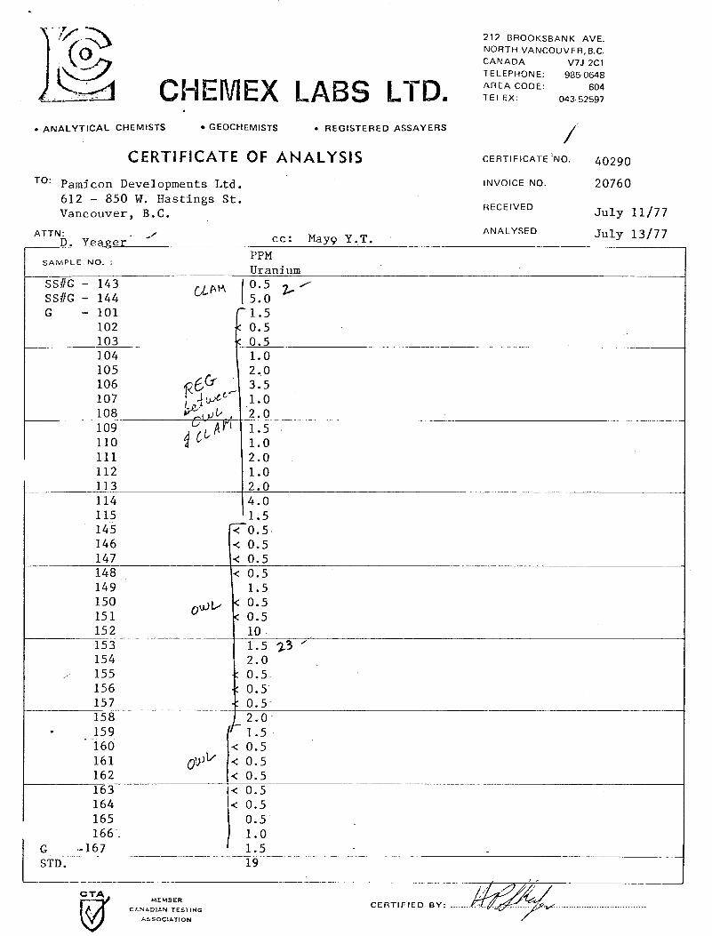
were sent foranalysisto Chemex Labs, Ltd, in North Vancouver,
B.C. and upon receipt were analysed for uranium using
standard fluorometric procedures Csee Appendix I1 for
complete descriptions of the procedures used for both
water and silt geochemical analysis).
TABLE 7.1 - Water - Geochemistry Results
Water Sample Number - Data By:
G 001 Pamicon
G 002 Pamicon
G 003 Pamicon
G 006 Pamicon
G 007 Pamicon
G 008 Pamicon
764-354 GSC
764-355 GSC
764-356 GSC
764-357 GSC
764-358 GSC
764-359 GSC
764-360 GSC
764-393 GSC
764-394 GSC
764-395 GSC
764-396 GSC
764-398 GSC
9 ...
Pamicon Developments Ltd.
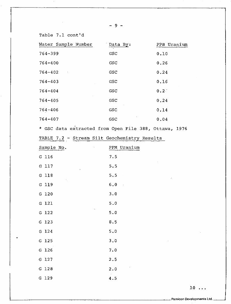
Table 7.1 contld
Water Sample Number
764-399
764-400
764-402 .
764-403
764-404
764-405
764-406
764-407
- 9 -
Data By:
GSC
GSC
GSC
GSC
GSC
GSC
GSC
GSC
PPB Uranium
0.10
0.26
0.24
0.16
0.2-
0.24
O,l4
0.04
* GSC data extracted from Open File 388, Ottawa, 1976
TABLE 7.2 - Stream Silt Geochemistry Results Sample No. - G 116
G 117
G 118
G 119
G 120
G 121
G 122
G 123
G 124
G 125
G 126
G 127
G 128
G 129
PPM Uranium -
7.5
5.5
5.5
6.0
3.0
5.0
5.0
8.5
5.0
3.0
7.0
2.5
2.0
4.5
b Pamicon Developments Ltd.

Table 7.2 conttd%
Sample No. - G 130
G 131
G 132
G 133
G 134
G 145
G 146
G 147
G 148
G 149
G 150
G 151
G 152
G 153
G 154
G 155
G 156
G 157
G 158
G 159
Figure 4 has 3 4
PPM Uranium
2.5
1.5
0.5
(0.5
1.5
t 0.5
4 0.5
4 0.5
< 0.5
1.5
.( 0.5
4 0.5
10.0
1.5
2.0
40.5
(0.5
4 0.5
2.0
1.5
silt sample locations and values plotted
in addition to the water sample data. Stream silts were
collected every 500 feet along the watercourses on or
adjacent to the OWL 1-20 mineral claims. Silt size sediment
11 ... Pamicon Developments Ltd. 1

- 11 - was placed in numbered, kraft sample envelopes and sent to
Chemex Labs. Ltd. in North Vancouver, B.C. for analysis of
parts per million uranium.
Both the silt and water geochenical sampling determined
anomalous uranium values are present. Water geochemistry
on Owl Creek had values of 1.2, 1.6, 1.5, 1.6, 2.6, 2.0
and 3.4 ppb uranium. All results are considered anomalous.
One anomalous value of 6.6 ppb uranium from the creek west of
the OWL group was recorded. With respect to the silt
sampling, Owl Creek results ranged from .5 ppm to 8.5 ppm
uranium. These values are considered slightly to
moderately anomalous. Values on the creek west of the OWL were
all below 5 ppm uranium and to the east only one value of
10 ppm uranium was considered anomalous.
8.0 - DISCUSSION AND CONCLUSIONS
The OWL 1-20 mineral claims contain anomalous values
of uranium in silt and water samples. The low percentage
of outcrop (10%) limits visual exploration methods. A better
understanding of the geology of the entire POOL group may lead
to specific exploration targets on the OWL 1-20 mineral
claims in the future. Overall, the favourable lithologies,
structures and geochemistry suggest further work is required
on the property.
L Pamicon Developments Ltd. -
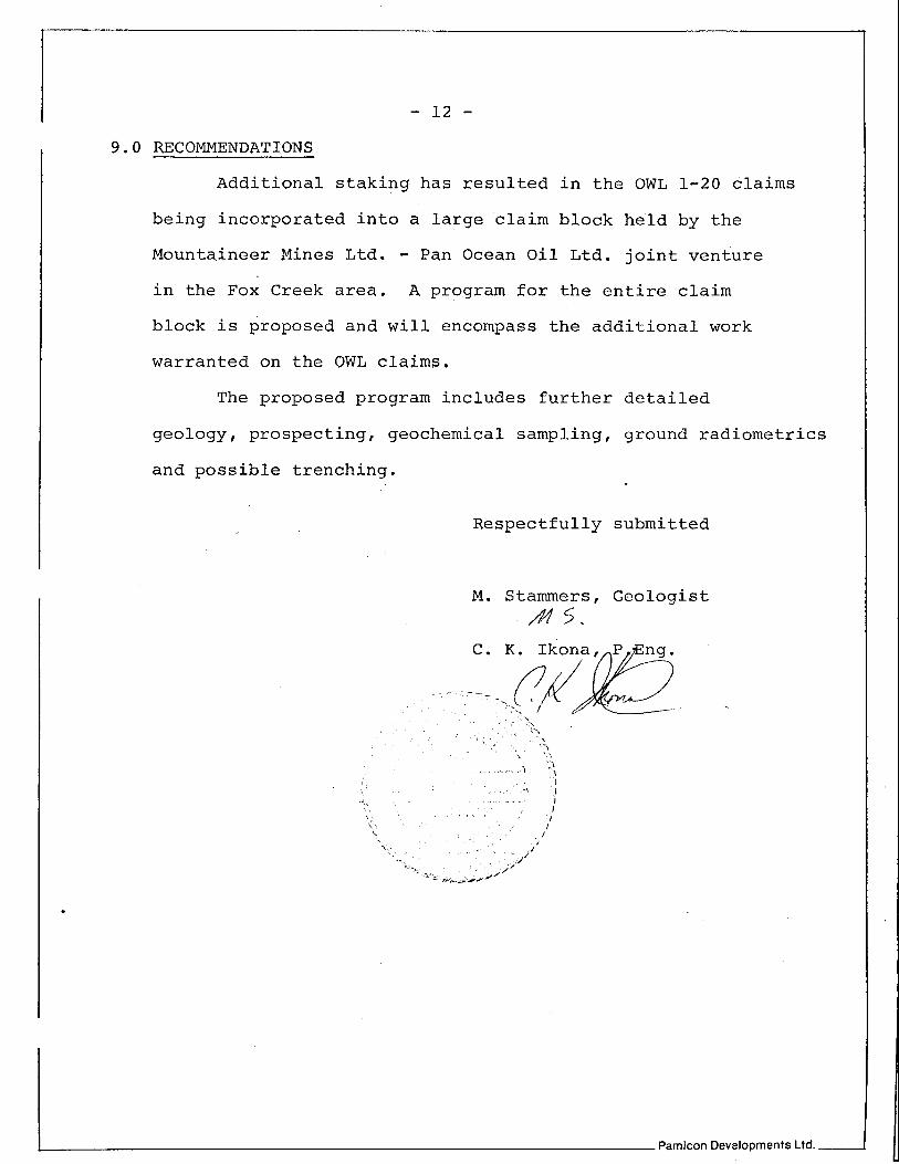
9.0 RECOMMENDATIONS
Additional staking has resulted in the OWL 1-20 claims
being incorporated into a large claim block held by the
Mountaineer Mines Ltd. - Pan Ocean Oil Ltd. joint venture in the Fox Creek area. A program for the entire claim
block is proposed and will encompass the additional work
warranted on the QWL claims.
The proposed program includes further detailed
geology, prospecting, geochemical sampling, ground radiometric
and possible trenching.
Respectfully submitted
M. Stammers, Geologist A4 5 .
& Pamicon Developments Ltd.

APPENDIX I1
A n a l y t i c a l methods f o r uranium p r e s e n t l y i n u s e a t Chemex have been modif ied from procedures developed by t h e USGS and GSC. For uranium a t PPB and PPM l e v e l , f l u o r o m e t r i c methods of ana lyses are h i g h l y accep tab le i n terms of accuracy , c o s t and t u r n around t ime.
The fo l lowing methods a r e used e x t e n s i v e l y t o de te rmine uranium p o t e n t i a l i n a v a r i e t y of m a t e r i a l .
( a ) Water Samples - By Fluorescence Ana lys i s
Clean 100 o r 200 ml p l a s t i c b o t t l e s a r e provided f o r f i e l d u s e . I f a p o r t i o n o f t h e wa te r i s t o be s t o r e d we r e q u i r e a 200 m l sample.
A 75 m l a l i q u o t i s t r a n s f e r r e d t o a c l e a n 100 'ml pyrex beake r . 3 m l of concen t r a t ed HN03 is added and t h e s o l u t i o n is evapora ted t o dryness a t l o w uniform temperature. The d r y r e s i d u e a f t e r a sh ing i s d i s s o l v e d i n 3 m l of warm 4M HN03. An a l i q u o t o f t h e d i s so lved r e s i d u e i s t r a n s f e r r e d t o a s m a l l p la t inum d i s h , d r i e d , and fused wi th a n 0.50g t a b l e t o f ca rbona te - f luo r ide f l u x a t 650° C. The fused d i s c is removed from t h e p l a t inum d i s h and uranium f luo rescence i s determined us ing a G. K.Turner I11 Fluorometer o r Ja r re l l -Ash 26-000 Fluorometer. D e t e c t i o n l i m i t i s 0.20 PPB U . A n a l y t i c a l c a p a b i l i t y approx. 200 samples p e r day i n c l u d i n g check samples and q u a l i t y c o n t r o l s t anda rds .
(b) . S o i l , S i l t , ~ a k e Bottom Sediments & Rocks - By F luo rescence Analvs is
These m a t e r i a l s normal ly a r r i v e unprepared. P r e p a r a t i o n r e q u i r e s d r y i n g @ 60° C and s c r e e n i n g t o o b t a i n t h e -80 mesh f r a c t i o n . Coarse m a t e r i a l i s r e t a i n e d i f t h e screened f r a c t i o n i s sma l l . A 0.25 gm sample of -80"mesh m a t e r i a l is weighed i n t o a 100 m l pyrex beaker . The sample i s ashed a t 550° C t o remove o r g a n i c s . The ashed r e s i d u e i s d i g e s t e d i n 5 mls 4M HNO3 and taken t o d ryness twice. The r e s i d u e i s leached i n 50 d s 1% HN03. The s o l u t i o n i s s w i r l e d and allowed t o s e t t l e . A few m i c r o l i t r e s of
. . . . . . 2
CHEMEX

Uranium - Page 2.
t h e c l e a r s o l u t i o n i s t r a n s f e r r e d by m i c r o p i p e t t e t o a p la t inum d i sh . , The sample i s evapora ted t o d ryness and a n 0.50 gm t a b l e t of carbonate - f l u o r i d e f l u x i s added t o t h e sample d i s h . Fusion and f l u o r o m e t r i c de t e rmina t ion of uranium is a s d e s c r i b e d f o r water samples. De tec t ion l i m i t i s 0.50 PPM U. A n a l y t i c a l volume approx. 400 samples p e r day i n c l u d i n g d u p l i c a t e s and q u a l i t y c o n t r o l s t anda rds . Upper l i m i t o f a n a l y t i c a l method - 400 PPM U.
(c) . Assay M a t e r i a l s (% U20R) By Colorimetr ic 'Methods - -
1 gram of homogenized sample pu lp i s weighed i n t o a Te f lon d i s h and d iges t ed w i t h 1 0 m l s 52% HF, 5 m l s 70% HC104 and 5 mls conc. HN03 t o dryness . The r e s i d u e i s d i s s o l v ~ d i n 25 mls 9M HC1. The uranium i s s e p a r a t e d from i n t e r f e r i n g elements by a n i o n exchange procedures . The adsorbed uranium i s e l u t e d form t h e r e s i n and a s u i t a b l e p o r t i o n o f t h e uranium b e a r i n g s o l u t i o n i s reduced, f i l t e r e d and t h e n complexed us ing Arsenazo I11 reagent . Absorbance i s measured u s i n g "Spectronic 700" Spec t ro- photometer. The U308 c o n c e n t r a t i o n i s eva lua t ed by c o r r e l a t i o n w i t h a s t anda rd r e f e r e n c e curve. A n a l y t i c a l volume - 40 samples/ day. Concent ra t ion range 0.001% U308 t o 10.0% U308.
CHEMEX

212 BROOKSEANK AVE. NORTH VANCOUVER, B C. CANADA V7J 2C1 TELEPHONE 985-0648
A CHEMEX LABS LTD. T~;:&CO~~:
604 043-52597
. ANALYTICAL CHEMISTS GEOCHEMISTS REGISTERED ASSAY ERS
CERTIFICATE OF ANALYSIS CERTIFICATE NO. 40288
TO: Pamicon Developments Ltd . INVOICE NO. 20759 612 - 850 W. Hastings S t . Vancouver, B.C. RECEIVED ~ u l y 11/77
I M E M B E R
/ CANADIAN TESTING
ASSOCIATION
212 BROOKSBANK AVE. NORTH VANCOUVER,B C. CANADA V7J 2C1 TELEPHONE. 985 0648 AREA CODE: W EMEX LABS L1-Dm TELEX 043.52597 604
. ANALYTICAL CHEMISTS GEOCHEMISTS 0 REGISTERED ASSAYERS / CERTIFICATE OF ANALYSIS CERTIFICATE 'NO. 40290
Pamicon Developments Ltd. 612 - 850 W. Hastings S t . Vancouver, B.C.
INVOICE NO. 20760
RECEIVED July 11/77
ATTN: / ANALYSED July 13/77 D. Yeager -- cc: May9 Y.T.
166. 1.0 G -167 1.5 - STD. 19
L. MEMBER
C L N L D I A N TESTING CERTIF IED B Y : ........ ..................................
J-550CIATION