Palouse River and Coulee City Railroad Bridge 3 … River and Coulee City Railroad Bridge 3...
25
Washington State Palouse River and Coulee City Railroad Bridge 3 Alternative Route Feasibility White Paper December 2007
Transcript of Palouse River and Coulee City Railroad Bridge 3 … River and Coulee City Railroad Bridge 3...

Washington State
Palouse River and Coulee City Railroad Bridge 3 Alternative Route Feasibility
White Paper
December 2007
To comment on this document, you can
• Call the WSDOT State Rail and Marine Office at 360-705-7900 or 1-800-822-2015;
• Write to WSDOT, State Rail and Marine Office, P.O. Box 47407, Olympia, WA 98504-7407;
• Fax your comments to 360-705-6821; or
• E-mail your comments to [email protected]
For updates to this plan or to obtain additional information, visit www.wsdot.gov/rail/.
Persons with disabilities may request this information be prepared and supplied in alternative forms by calling collect 360-664-9009. Deaf and hearing-impaired people may call 1-800-833-6388 (TTY relay service).
Prepared by the State Rail and Marine Office, Freight Systems Division Washington State Department of Transportation December 2007

Palouse River and Coulee City Railroad Bridge 3 Alternative Route Feasibility
White Paper
Prepared for the
Washington State Department of Transportation By
HDR Engineering, Inc. December 2007


PCC Bridge 3 Alternative Route Feasibility December 2007 White Paper Page i
Table of Contents
Executive Summary .............................................................................1
What is the purpose of this paper?.............................................................................................1
Where is the PCC located? ........................................................................................................1
How did WSDOT assess the alternative routes? .......................................................................2
What are the conclusions of this paper? ....................................................................................3
Evaluation.............................................................................................5
What alternative routes are being considered? ..........................................................................5
Are the proposed routes suitable for a new rail line?.................................................................6
How much will the proposed routes cost? ...............................................................................15
What are the conclusions of this White Paper? .......................................................................17
What are the next steps? ..........................................................................................................18
References..........................................................................................19
Appendices
Appendix A, Proposed Routes
Appendix B, Union Pacific Track Chart
Appendix C, Cost Estimates

December 2007 PCC Bridge 3 Alternative Route Feasibility Page ii White Paper
Exhibits
1 General PCC and Study Area Vicinity Map ............................................................2 2 Thornton to Rosalia Connection ............................................................................13
Acronyms
BN Burlington Northern BNSF BNSF Railway FRA Federal Railroad Administration GN Great Northern MP milepost NP Northern Pacific PCC Palouse River and Coulee City Railroad S&IER Spokane & Inland Empire Railroad STB Surface Transportation Board UP Union Pacific WSDOT Washington State Department of Transportation WSU Washington State University 286k 286,000-pound railroad cars
PCC Bridge 3 Alternative Route Feasibility December 2007 White Paper Page 1
Executive Summary
What is the purpose of this paper?
In August 2006, a wheat field fire ignited a timber trestle located between Colfax and Pullman along the Palouse River and Coulee City Railroad (PCC). The bridge (Bridge 3), which the fire destroyed, connected two of that railroad’s branch lines: the PV Hooper Branch and the P&L Branch. Bridge 3 had provided the only direct connection between the Union Pacific Railroad and the P&L Branch.
According to an engineering review completed in July 2007, replacing the bridge will cost $1.5 million or $2.0 million depending on the type of structure that is constructed. As an alternative to rebuilding the destroyed bridge, the Washington State Department of Transportation (WSDOT) is examining the feasibility of rebuilding a rail line between Thornton, which is north of Colfax on the PV Hooper Branch, and the P&L Branch.
This White Paper provides basic information regarding cost and operational considerations of two proposed alternative routes between the PV Hooper and P&L Branches. It also discusses environmental and community issues. This paper follows industry-standard methodology to assess the conceptual feasibility of connecting the PV Hooper Branch at Thornton to a new location on the P&L Branch at either Oakesdale or Rosalia. Next steps are also presented.
Where is the PCC located?
The PCC and its branches are located in eastern Washington. The rail line travels through various towns, including Coulee City, Davenport, Saint John, Rosalia, Thornton, Hooper, Colfax, Oakesdale, Palouse, and Pullman. The area under study for this White Paper is located exclusively in Whitman County. Exhibit 1 shows the general location of the PCC, the P&L and PV Hooper Branches, and the general study area.

December 2007 PCC Bridge 3 Alternative Route Feasibility Page 2 White Paper
Exhibit 1 General PCC and Study Area Vicinity Map
How did WSDOT assess the alternative routes?
In April 2007, W. Casey Harmon, a student at Washington State University (WSU), prepared a report entitled Thornton to Oakesdale Renaissance?1 The report considered the feasibility of building two alternative line segments instead of rebuilding Bridge 3. With Mr. Harmon’s permission, the project team used his report as a first step in determining the feasibility of the proposed routes. It formed the basis for exploring alternatives to rebuilding Bridge 3, provided the foundation for the analysis presented in this report, and included a number of important insights that were affirmed by this study.
The project team conducted field surveys and prepared analyses necessary to confirm and build upon the Harmon paper. The project team conducted an independent review of engineering and environmental fatal flaws for each route. It evaluated the concept-level design and the operational and institutional feasibility of rebuilding the two alternative routes (Thornton to Oakesdale and Thornton to Rosalia). The project team then developed order-of-magnitude cost estimates for the two alternatives assessed in the Harmon paper.
1 Referred to as the Harmon paper in this report.

PCC Bridge 3 Alternative Route Feasibility December 2007 White Paper Page 3
What are the conclusions of this paper?
At the conceptual level of review, fatal flaw analysis2 did not reveal any engineering or environmental obstacle that would prevent consideration of either route. However, right-of-way costs and impacts could be significant—a factor identified in the Harmon paper and confirmed by this report.
Reconstruction of the Thornton-to-Oakesdale route would cost about $10.54 million using new 90-pound rail and ties. However, rail, ties, and other items can be salvaged from the Colfax-to-Pullman line segment (the segment affected by the fire) for use in this route. If those materials are used, the cost drops to $7.25 million for a savings of $3.29 million. 3
The order-of-magnitude costs to construct the proposed Thornton-to-Rosalia route using materials salvaged from the Colfax-to-Pullman line segment is estimated to be $11.2 million, which is much higher than the Thornton-to-Oakesdale route. Costs escalate even further if the work needed to make the Thornton-to-Rosalia route operationally efficient is considered.
Both routes are considerably more expensive to build than replacing Bridge 3 on the Colfax-to-Pullman segment. However, that segment presents other challenges: other bridges need repairs; the track should be rehabilitated and improved; the line has low traffic volumes and no customers between Pullman and Colfax; and, the line is difficult and expensive to maintain due to its proximity to the Palouse River and the many curves along the segment. The Harmon report also identified potential beneficial use of the abandoned rail bed between Colfax and Pullman as a regional trail or public right of way. Investigating those factors will shed more light on cost and provide a benefit-cost analysis that weighs cost against a more complete assessment of benefits.
During the course of the study, it was learned that the Union Pacific Railroad (UP) already has a physical connection with the P & L Rail Line at Marshall. However, UP operates over the BNSF Railway Co. (BNSF) tracks at that point. Current agreements involving UP, BNSF and the current operator of the P & L Rail Line makes interchange between the UP and the operator of
2 A fatal flaw analysis is a term often used when evaluating design alternatives or new routes. If it is found that the proposed design/route would have a major environmental or community impact which could not be avoided by redesign (or mitigation), the design/route would then be considered to have an environmental fatal flaw. An engineering fatal flaw would result if the rail line could not be constructed to meet standard design and operational standards.
3 Additional estimates were developed for this alternate route, and are included in the Evaluation section. The figures presented here represent the preferred construction estimate.
December 2007 PCC Bridge 3 Alternative Route Feasibility Page 4 White Paper
the P & L line uneconomical for most commodities. If the State continues to study alternatives to replace Bridge 3, it may want to consider working with the railroads to overcome the difficulties with the current arrangements as an alternative or interim way to reconnect the UP to the P & L.
If WSDOT determines that further study of the routes is warranted, a broader and more detailed study needs to be performed. The probable next steps are outlined beginning on page 18.

PCC Bridge 3 Alternative Route Feasibility December 2007 White Paper Page 5
Evaluation
What alternative routes are being considered?
Two routes are under review: Thornton to Oakesdale and Thornton to Rosalia. Appendix A presents the general location of these proposed routes.
Thornton to Oakesdale
This proposal would rebuild the original rail line route that was developed by the Oregon Railway Extension Company between 1888 and 1889, and then became part of the Union Pacific Railroad . This route, located between rail milepost (MP) 31.8 and MP 39.5, was known as the Pleasant Valley Branch. See Appendix B (UP track chart) for more information and locations of rail mileposts referred to throughout this paper. According to the Harmon report, the segment between Thornton and Oakesdale was abandoned in 1992.
The route would tie onto existing track in the original layout at both Thornton and Oakesdale, and would match the profile of the former rail line. At Oakesdale, this design would allow a through movement from Thornton to stations south of Oakesdale (such as Palouse or Pullman). This proposed route is about eight miles long.
Thornton to Rosalia
This proposal would rebuild the original rail line route that was developed by the Spokane & Inland Empire Railroad (S&IER) in the early 1900s, and then became part of the Great Northern Railroad (GN). When the Burlington Northern (BN—BN is the predecessor of the BNSF) was formed in 1970, two of the railroads in the Palouse region, the GN and the Northern Pacific (NP), became part of the national BN system. Throughout the 1970s the BN went through a process of “rationalizing” its lines, particularly those that appeared to be redundant or too costly. The Thornton-to-Rosalia segment was viewed to be less desirable than the nearly parallel former NP line that is referred to today as the P&L Branch. Under the Thornton-to-Rosalia proposal, this segment would be rebuilt on its original route and profile using the most direct connections possible.
The route would tie onto existing track, in the original design at both Thornton and Rosalia, and would match the profile of the former rail line. However, additional connecting tracks may be needed as shown on Exhibit 2.

December 2007 PCC Bridge 3 Alternative Route Feasibility Page 6 White Paper
Are the proposed routes suitable for a new rail line?
The project team performed a site survey in September 2007 where they reviewed the proposed routes, the environmental and community conditions in the study area, and the feasibility of building a rail line within the existing terrain. The following presents the project team’s general observations from an engineering and environmental perspective. Appendix A presents illustrations of the two proposed routes that show potential challenges.
Thornton to Oakesdale
During its site visit, the project team was able to parallel the proposed route for about 95 percent of its distance. For most of the route, the rail bed is adjacent to and south of Finch Road and Trestle Creek Road.
Engineering Fatal Flaw Analysis
Based on field observations and professional judgment, no fatal flaws were identified for the Thornton-to-Oakesdale proposed route. However, the following engineering observations were made:
• Former rail grade: The majority of the former grade remains intact. At the terminus in Thornton, the grade has been plowed and is being farmed in some areas. However, no large cuts have been filled nor have any large embankments been removed. It is evident in some locations that the subgrade is largely still present because the crops are not growing well due to the presence of ballast and subballast.
Over the majority of the route, suggested general repairs would consist of:
• In areas where the former rail bed is at-grade or in a cut, the topsoil would be removed by clearing and grading, the rail bed should be compacted, ditches reestablished, and slopes would be reshaped and stabilized as needed.
• In areas where the rail bed is above-grade, the vegetation and fouling materials would be removed, from the rail bed only, followed by minor grading and compaction of that portion of the embankment.
Between former MP 38.6 and MP 38.8 in Oakesdale, the rail bed was on a shallow embankment that has been removed. In order to meet the subgrade west of this point and the elevation of the existing bridge at MP 38.6,
Bridge at MP 38.6
PCC Bridge 3 Alternative Route Feasibility December 2007 White Paper Page 7
Burned bridge at MP 33.16
this embankment would need to be rebuilt. Further east of this point, the grade is somewhat confined between a structure and a steep embankment. However, there is nothing that currently prevents rebuilding of the grade and track.
Near MP 36.6, which is the high point of the segment, the grade is in poor condition because of the collapsing slopes in the relatively deep cut at this location. Also, the ditches and grade are fouled with mud and there is evidence that there is regular runoff or a seep. However, the repairs required to stabilize the slopes, provide drainage, and reestablish the grade would be straightforward.
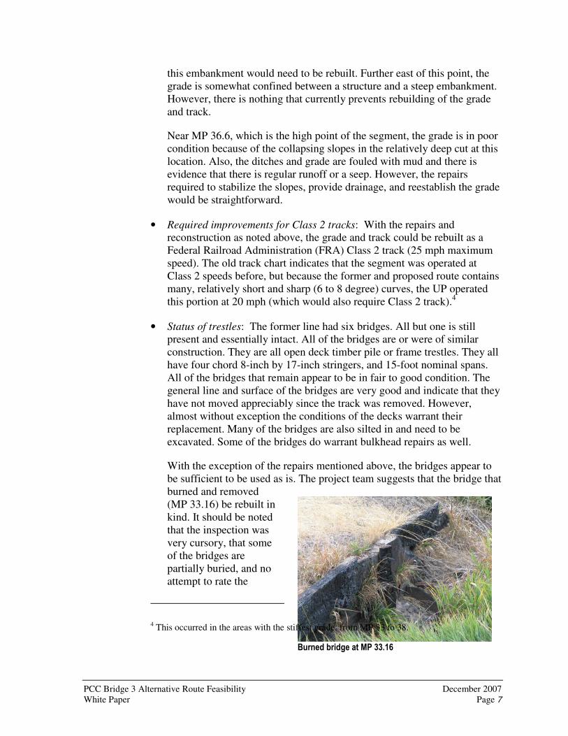
• Required improvements for Class 2 tracks: With the repairs and reconstruction as noted above, the grade and track could be rebuilt as a Federal Railroad Administration (FRA) Class 2 track (25 mph maximum speed). The old track chart indicates that the segment was operated at Class 2 speeds before, but because the former and proposed route contains many, relatively short and sharp (6 to 8 degree) curves, the UP operated this portion at 20 mph (which would also require Class 2 track).4
• Status of trestles: The former line had six bridges. All but one is still present and essentially intact. All of the bridges are or were of similar construction. They are all open deck timber pile or frame trestles. They all have four chord 8-inch by 17-inch stringers, and 15-foot nominal spans. All of the bridges that remain appear to be in fair to good condition. The general line and surface of the bridges are very good and indicate that they have not moved appreciably since the track was removed. However, almost without exception the conditions of the decks warrant their replacement. Many of the bridges are also silted in and need to be excavated. Some of the bridges do warrant bulkhead repairs as well.
With the exception of the repairs mentioned above, the bridges appear to be sufficient to be used as is. The project team suggests that the bridge that burned and removed (MP 33.16) be rebuilt in kind. It should be noted that the inspection was very cursory, that some of the bridges are partially buried, and no attempt to rate the
4 This occurred in the areas with the stiffest grade, from MP 33 to 38.

December 2007 PCC Bridge 3 Alternative Route Feasibility Page 8 White Paper
Sidewalk along South 3rd Street
bridges was done. The bridges may not be suitable for 286, 000 pound car loading (286k), particularly in the long term.
• Other grade work: Besides the grade related work mentioned above, an investigation and evaluation of existing culverts would be needed. At the proposed at-grade crossings, the grade would need to be rebuilt within the limits of the roadway. The streets and roads would possibly need some approach work to match the new track and the resulting road profile change.
• Salvage of rail: If a new line segment from Thornton is built rather than rebuilding Bridge 3, the Colfax-to-Pullman segment would probably be abandoned. If 90-pound rail for the new segment from Thornton is sufficient, there is more than enough material that could be removed from the Colfax-to-Pullman segment and used for the proposed segment.
Ninety-pound rail is usually considered insufficient for new construction, particularly if 286k traffic is expected. However, considering that the new segment is a substitute for the Colfax-to-Pullman route, and that material would presumably become available from that line’s removal, the use of the 90-pound rail seems reasonable to consider. In any event, the new segment would probably not carry 286k cars because it would connect to the PV Hooper Branch, which contains over 20 miles of 75-pound rail.
The crossties in the Colfax-to-Pullman segment might not be suitable for reuse. It is presumed that many, if not a majority, of the ties might be of scrap or “landscape” condition. Additional rail might have to be removed to free up sufficient quantity of second hand or “relay” condition5 ties that would allow for the construction of the segment with a larger percentage of salvage ties.
5 The terms “second hand” and “relay” refer to materials suitable for reuse, and apply to rail as well as other track materials.

PCC Bridge 3 Alternative Route Feasibility December 2007 White Paper Page 9
• Grade crossings: Eight public at-grade crossings would be required if roads are not closed or grade-separated. Five of the eight crossings are located in Oakesdale and are essentially city streets or local access roads. These roads are: South 5th, South 4th, South 3rd, South 2nd, and South Front Streets. The three roadways located outside of Oakesdale are rural roads, two of which are gravel (Kilpatrick and Eckhart Roads) and one paved (Crow Road).
There may be a need to signalize South 2nd and South 3rd Streets due to the slightly larger traffic count, the nearby school on South 2nd Street, and the through nature of South 3rd Street (which turns into Oakesdale Road). These crossings also have limited sight distance. South 2nd and 3rd Streets will likely warrant concrete panel crossings with sidewalks. The remaining crossings could be constructed with a wood plank surface. In addition to these crossings, the project team estimates the need for up to six wood plank private crossings for farm access.
Environmental Fatal Flaw Analysis
The Harmon report identified right-of-way acquisition as perhaps the most significant issue facing reconstruction of the proposed new segments. Right-of-way issues were expressly not included in this analysis, but the condition and existing uses of the right of way were considered in this environmental review. The project team agrees with the Harmon report that the right-of-way acquisition issue is significant to the feasibility of this project.
Based on the project team’s site visit and review of existing environmental documentation, no environmental fatal flaws were identified. Environmental elements will still need to be considered with any rehabilitation of the line, but at this point it does not appear that significant environmental obstacles are present within the project study area.
The railroad right of way between Thornton and Oakesdale has been vacated for many years. All ties and rail have been removed from the right of way. Evidence of the historic rail bed is present in the remaining grade, with visible cuts, fills, and bridges. The right of way is farmed in places and in other places used as open space or as a road. Land use is almost entirely agricultural, and communities are dependent upon agricultural economies.
Old farm structure located near the proposed route

December 2007 PCC Bridge 3 Alternative Route Feasibility Page 10 White Paper
Waterways and Streams
All of the bridges identified within this track section cross creeks that eventually flow to the Palouse River. The Palouse River Watershed is referred to as Water Resource Inventory Area (WRIA) #34. The Palouse River, WRIA
34 Watershed Plan was reviewed as part of the project team’s data collection effort. According to the Palouse Watershed Plan Final Draft (August 2007), none of the tributaries located in the study area support anadromous fish resources. The Palouse River Falls located near the Palouse River confluence with the Snake River blocks upstream fish migration. As a result, the Palouse River above the falls does not support anadromous salmonids and does not provide critical habitat for ESA-listed fish species.
From Thornton to the US 195 bridge, the embankment parallels Thorn Creek. Finch Road follows the right of way east of US 195 for about four miles to its intersection with Trestle Creek Road, which leads into the town of Oakesdale. Between Thornton and Oakesdale there are five existing bridges, and one bridge that has been removed and would need to be replaced. Although the project team did not inventory or review culverts along the route, at least one large culvert would be required.
Wetlands
Wetlands are present within the drainage corridors, but the wetlands observed are small, serve primarily water quality treatment functions, do not represent priority habitats, and are unlikely to support listed threatened or endangered species. These drainages and wetlands are regularly disturbed by agricultural practices and contain very few native plant species. Wetlands may be impacted by rebuilding the rail line near the identified bridges. The only other wetland observed occurs near the Thorn Creek - Trestle Creek watershed divide. Near this summit a wetland was observed near an unstable slope. Improvements would
MP 38.6 downstream drainage
End of existing track in Oakesdale

PCC Bridge 3 Alternative Route Feasibility December 2007 White Paper Page 11
likely affect this small wetland. The wetland observed in this area is low quality and dominated by common cattails.
Community and Land Use
The proposed route travels through farmland and open space. Oakesdale is the only location along this route where there is a potential for impacts to community residents and social services (emergency and school vehicles at grade crossings). Residences, a school, and commercial buildings are located very near the rail line in this area. The rail bed appears to have been removed within the western portion of Oakesdale, and this area serves as an open space for the residents in the area. Further east in Oakesdale, commercial and industrial land uses are dominant. New sidewalks are present in Oakesdale and an improved rail line would cross these pedestrian areas.
The Harmon report noted that if the Colfax-to-Pullman segment was abandoned, the rail bed could be used as a regional trail or public right of way. This use may be a benefit that offsets some of the costs of the building a new line segment, and may also be an attractive incentive to public reviewers concerned about community disruption caused by the project. The potential benefit of a rails-to-trails project would apply to both proposed routes.
Thornton to Rosalia
During its site visit, the project team was able to parallel the proposed route for about 90 percent of its distance. The former rail bed was driven for almost 30 percent of the route.
The old rail bed is evident most of the way between the two towns. Starting at the Thornton end, the former rail bed parallels the Old Thornton Highway for almost three miles. All of the significant timber trestle bridges on the former line have been removed.
Traveling from Thornton towards Rosalia, it is apparent that two bridges were removed. The first was located just out of
Thornton Bypass Road and old track bed
Missing Culvert in Rosalia
December 2007 PCC Bridge 3 Alternative Route Feasibility Page 12 White Paper
Thornton and was a grade separation over the top of Thornton Bypass Road. This bridge was about 100 feet long. The next bridge was also a grade separation over the Old Thornton Highway. It was about 150 feet long.
Proceeding towards Rosalia, the team observed that there was a washout and missing culvert in the former rail bed. Continuing north, the former line veers west and ends up parallel to Cashe Creek Road. A short distance further the line swings to the east again and away from the road at the former station of Balder. It appears the railroad served the large grain elevator still present there. From this point, the former rail bed becomes a usable farm road. The rail line climbs to a summit then descends to Gale Road where there was another grade separated crossing of the road on a pile timber bridge. From this point the old rail bed swings to the east and then north as it heads into Rosalia. This portion could not be closely observed but at the team could see that at least one other timber bridge over a drainage had been removed. The rail line continues into town and passes through a viaduct.
Engineering Fatal Flaw Analysis
No engineering fatal flaws were observed during the project team’s site visit in September 2007. However, the following discussion describes the opportunities and obstacles regarding the proposed route and connections.
The Rosalia to Thornton segment was part of a through route that connected Spokane and Colfax. However, the connections at Thornton and Rosalia were not designed for operational efficiency for the currently proposed use of the corridor. Although the connection for traffic flowing between Marshall and Winona is relatively simple, the changes needed for efficient traffic flow between Oakesdale and Winona create difficulties that are costly to overcome. Those difficulties and possible solutions are discussed in the following paragraph and shown in Exhibit 2.
As mentioned above, the operational difficulties arise for trains traveling from Winona to Oakesdale via Rosalia. Two “run-around” movements may be needed to keep the locomotives on the head end of the train. The Thornton end is fairly straightforward to redesign to avoid a runaround move. However, the proposed design at Thornton would require a fairly significant embankment, a bridge over the Thorn Creek drainage, and two at-grade crossings. The Rosalia end is more challenging. The line would have to swing about 180 degrees to the south, negotiate a stiff grade and a very sharp curve to cross the Old State Highway Road on a grade separation, and cross Pine Creek on a small bridge. The changed connections needed at Thornton and Rosalia add significant costs to the proposed route.

PCC Bridge 3 Alternative Route Feasibility December 2007 White Paper Page 13
Exhibit 2 Thornton to Rosalia Connection
December 2007 PCC Bridge 3 Alternative Route Feasibility Page 14 White Paper
Four public at-grade crossings need to be reinstalled on the Thornton-to-Rosalia segment. This presumes that the three grade-separations are rebuilt. In addition, about six private farm crossings may also be needed for this route. Another crossing would be required if the alternate connection design needed for operational efficiency was pursued.
Environmental Fatal Flaw Analysis
Right-of-way acquisition is also an important factor to consider for the Thornton-to-Rosalia route. Because new (not previously occupied) right of way may be required to complete this segment, right-of-way issues may play an even more critical role in the schedule and cost associated with reopening this segment. Right-of-way issues were expressly not included in this analysis, but the condition and existing uses of the right of way were considered in this environmental review.
Based on the project team’s site visit and review of existing environmental documentation, no environmental fatal flaws were identified. Environmental elements will still need to be considered with any rehabilitation of the line, but at this point it does not appear that significant environmental obstacles are present within the project study area. This rail line was constructed within a similar time period to the section evaluated between Thornton and Oakesdale. It displays less of the rail line features because all of the bridge structures have been removed. Some of the right of way is farmed, some of it is used as a road, and some of it is used as farm road. This proposed route would likely require construction of new bridges over Pine Creek at Rosalia and possibly over Thorn Creek at Thornton to provide efficient rail service.
Waterways and Streams
The project crosses the small tributary streams of Thorn Creek, Cache Creek, and Pine Creek. These streams are also tributary streams of the Palouse River. Building this route would not affect anadromous fish or listed fish species. The Thorn Creek crossing may be required if a new wye connection is made with the rail line to allow for a direct access to the Union Pacific track. The Cache Creek crossing is within a culvert, and would not be affected by the construction. The Pine Creek Bridge would be required at the north end in order to tie the rail line to the active P&L track. This would require some wetland fill. As such, further hydrologic and environmental studies would be required if this bridge is to be built.

PCC Bridge 3 Alternative Route Feasibility December 2007 White Paper Page 15
Wetlands
Wetlands are present along the Thorn Creek and the Pine Creek drainages. These wetlands may be affected by the track work. These wetlands are not likely to support threatened or endangered species and are heavily impacted by ongoing farming practices. Impacts could be mitigated.
Community and Land Use
The proposed route travels through farmland or open space. Some residences exist in both Thornton and Rosalia, but roadways are very near the railroad corridor at these locations and other rail facilities are also in these areas.
How much will the proposed routes cost?
Order-of-magnitude cost estimates were developed for each of the routes. Detailed cost estimates are included as Appendix C. Cost estimates can be conceptual, preliminary, or final (or someplace in between each of these steps, depending upon the level of project design). For conceptual (order of magnitude) cost estimates, known information is compiled, and then industry-wide, standard format, unit costs are used to estimate how much a specific item would cost. For example, in order to estimate the cost of rail for a 10,000-foot siding, that length is multiplied by the current, industry standard cost for the specific rail that would be used.
The specifics of construction are not available during the conceptual stage of engineering. The unknown site-specific information causes the cost of the individual items to vary. A contingency6 of 30 percent is sufficient to cover issues found during engineering in a project corridor, and the cost of environmental mitigation will generally be 10 to 20 percent of the construction total. In this case, the project team felt that mitigation costs would be lower—estimated at five percent of total construction—because the proposed projects are rebuilding track on existing rail beds that were used for the same purpose. The environmental contingency is used to ensure that any mitigation that may be necessary is accounted for in the conceptual cost. At
6Contingency is an amount intended to cover unknown costs. As the level of detail in project plans increases, the contingency in the estimate is reduced because there is less that is unknown. The contingency in the final engineered estimate is small because the estimate includes all information that it is possible to know without beginning construction. There are almost always surprises, but their effect is generally small enough to fall within the contingency amount. Occasionally, a surprise such as the discovery of historical artifacts or underground water can have an impact that exceeds the amount estimated for contingency.
December 2007 PCC Bridge 3 Alternative Route Feasibility Page 16 White Paper
the conceptual level, it is rarely known what, if any, mitigation might be required.
Thornton to Oakesdale
1. Order-of-magnitude cost for rebuilding this route is $7.25 million dollars including tax and a 30 percent contingency. This estimate was based on assumptions discussed earlier in this paper, as well as on the following:
a. About eight miles of jointed track will be removed from the Colfax-to-Pullman segment. It is presumed that the spikes, bolts, anchors, and one third of the ties will be replaced.
b. A cursory inspection indicates that about two thirds of the ties are considered reusable and the remaining one third will be disposed.
c. A cursory inspection indicates that new subballast will need to be installed on only 25 percent of the route.
2. Order of magnitude cost for rebuilding this route is about $10.54 million dollars based on the above assumptions except that 90-lb second hand (relay) materials and new ties will be directly furnished by a contractor instead of using salvage (relay) materials released by removal of a portion of the Colfax-to-Pullman line segment.
3. Order of magnitude cost for the reconstruction of this route is about $11.54 million dollars based on the above assumptions except that 112-lb (or heavier) relay materials and new ties will be directly furnished by a contractor.
4. Order of magnitude cost for the reconstruction of this route is about $10.75 million dollars based on the above assumptions except that 112-lb (or heavier) relay materials and second hand relay ties will be directly furnished by a contractor.
Thornton to Rosalia
1. Order of magnitude cost for rebuilding this route is $11.2 million dollars using the same assumptions as those in 1. under Thornton to Oakesdale, and assuming that the simple connection on both the Thornton and Rosalia ends of the route will be constructed rather than the connections needed to prevent runaround moves.
2. If the Thornton end is configured in the “through route” configuration the costs would be higher, due to the need for additional grade work, another bridge structure, and two at-grade crossings. Given the cost of the “simple” route in 1, an estimate for this design was not made.
PCC Bridge 3 Alternative Route Feasibility December 2007 White Paper Page 17
3. At the Rosalia end, the alternate configuration (that would allow a train to head south) would require additional grade work and possibly another grade-separation structure. Given the cost of the “simple” route in 1, an estimate for this design was not made.
4. Given the much higher cost for this route, estimates using other materials were not made.
Appendix C provides more detailed information about these costs. Shaded areas on the cost worksheets were not considered as part of the cost estimates.
What are the conclusions of this White Paper?
Using industry-standard methodology and its professional judgment, the project team analyzed the proposed alternative routes with the available data, and engineering, environmental and cost factors. Both routes can be built. However, construction of the Thornton-to-Oakesdale alternative is the best one from an operational and cost viewpoint.
The alternative routes are considerably more expensive than replacing Bridge 3 on the Colfax-to-Pullman segment. However, there are important factors that must be considered in addition to cost, including likely traffic volumes and operational efficiency. The Harmon report also identified potential beneficial use of the abandoned rail bed between Colfax and Pullman as a regional trail or public right of way. Investigation of those factors will shed additional light not only on cost, but also provide a benefit-cost analysis that weighs cost against a more complete assessment of benefits.
December 2007 PCC Bridge 3 Alternative Route Feasibility Page 18 White Paper
What are the next steps?
If the State decides to move forward with exploring a new route between Thornton and either Oakesdale or Rosalia, it may want to develop more refined engineering, right-of-way, environmental and business analyses to make a final decision about whether Bridge 3 should be rebuilt or which alignment to pursue. In general terms, a benefit-cost analysis is needed for rebuilding Bridge 3 and for constructing each of the proposed new routes. In order to prepare such analyses, the following would be needed for each proposal at a minimum:
1. Investigate community impacts, especially those in Oakesdale because the proposed Thornton-to-Oakesdale route runs directly through the city.
2. Conduct further investigation into operational benefits and challenges.
3. Identify shipping demand likely to be generated or lost, shifts of freight among transportation modes, and other business impacts.
4. Identify ownership of abandoned rights of way and costs of buying the needed right of way.
5. Identify regulatory challenges: specifically, Surface Transportation Board (STB) requirements and procedures.
6. Conduct a more detailed engineering analysis and cost development of the alternative routes.
7. Review environmental challenges in greater detail.
The State may also want to explore the possibility of working with the BNSF, UP and the operator of the P & L Rail line to make UP access to the P & L Rail Line at Marshall more economical.

PCC Bridge 3 Alternative Route Feasibility December 2007 White Paper Page 19
References
Harmon, W. Casey. Thornton to Oakesdale Renaissance? Washington State University, April 2007.
HDR Engineering, Inc. Palouse Watershed Plan Final Draft, prepared for the Washington State Department of Ecology, August 2007.
HDR Engineering, Inc. Palouse River Bridge Replacement Concept Design Study,
prepared for the Washington State Department of Transportation, July 18, 2007.