Paleogeography and Sedimentation Settings during …palaeoentomolog.ru/Lib/Chumakov1.pdf ·...
24
340 Stratigraphy and Geological Correlation, Vol. 9, No. 4, 2001, pp. 340–363. Translated from Stratigrafiya. Geologicheskaya Korrelyatsiya, Vol. 9, No. 4, 2001, pp. 29–54. Original Russian Text Copyright © 2001 by Zharkov, Chumakov. English Translation Copyright © 2001 by åÄIä “Nauka /Interperiodica” (Russia). 1. INTRODUCTION Permian and Early Triassic climatic changes and reorganizations in biosphere are most remarkable in the Phanerozoic history. They are manifested in transition from the glacial to ice-free climate, in growing aridity of Pangea (Parrish, 1993, 1995), and in mass extinction of marine and terrestrial faunas at the end of the Per- mian Period (Maxwell, 1989; Raup and Sepkoski, 1986; Erwin, 1995; Alekseev, 1998; Ochev and Shish- kin, 1998; Ponomarenko and Sukacheva, 1998; and others). Substantial changes affected all subsystems of biosphere and were accompanied by global changes in Sr, C, and S isotopic ratios (Burke et al., 1982; Baud et al., 1989; Denison and Koepnik, 1995; Erwin, 1995a; Scholle, 1995). The most intense biosphere reorganizations devel- oped since the second half of the Early Permian until the Induan Age of the Early Triassic. They were pre- ceded by durable paleogeographic and climatic changes, which should significantly influence sedimen- tation environments and, consequently, habitat condi- tions of organisms in the Pangea supercontinent and surrounding shelf seas and oceans. The interrelated succession of such changes is, however, insufficiently studied so far. This work is dedicated to most important paleogeo- graphic features and peculiarities in distribution of sed- imentation settings. To define them, we compiled glo- bal lithological–paleogeographic maps for three time slices: late Sakmarian–early Artinskian of the Early Permian (Fig. 1), late Kazanian–early Toarcian of the Late Permian (Fig. 2), and Induan Age of the Early Tri- assic (Fig. 3). Reconstructions prepared for the interna- tional project “Pangea” (Scotese and Langford, 1995; Golonka et al., 1994) global topographic schemes for every Permian age (Ziegler et al., 1997, 1998) were used as the cartographic base for these maps. The maps summarize and systematize data published in works presented in the reference list. Difficulties accompany- ing interregional correlation of Permian deposits are well known. Several slightly different schemes of such correlation were proposed recently. In this work, we used the stratigraphic scheme proposed for the project “Pangea” (Ross et al., 1994). Maps presented here are used to reconstruct most significant paleogeographic and depositional transformations that occurred on the Earth during the Permian and Early Triassic. Owing to known differences in correlation of events, the transfor- mation ages estimated here are conditional to a certain extent, but this does not affect their essence and succes- sion. 2. MAIN FEATURES OF THE PERMIAN–TRIASSIC PALEOGEOGRAPHY Comparing the lithological–paleogeographic maps, one can see that disposition of global paleogeographic features was almost unchangeable during the consid- ered time period. The Earth retained the longitudinal asymmetry: its oceanic hemisphere was occupied by the Panthalassa, and continental hemisphere congre- gated the huge Pangea continent, Paleotethys and Neot- Paleogeography and Sedimentation Settings during Permian–Triassic Reorganizations in Biosphere M. A. Zharkov and N. M. Chumakov Geological Institute, Russian Academy of Sciences, Pyzhevskii per. 7, Moscow, 109017 Russia Received November 30, 1999 Abstract—Origination and growing aridity of Pangea and transition from glacial to ice-free climate led in the Permian–Early Triassic to substantial reorganization in all biosphere subsystems. Lithological–paleogeo- graphic maps drawn for the late Sakmarian–early Artinskian and late Kazanian–early Toarcian periods of the Permian and for the Induan Age of the Early Triassic illustrate main paleogeographic changes that were related to the Pangea uplift, successive regression of epicontinental seas, disappearance of glacial sedimentation areas, progradation of arid and semiarid sedimentation, expansion and multiplication of closed basins, and reduced surficial but enhanced groundwater discharge into shelf seas surrounding Pangea. This distorted the global bal- ance of mineral exchange between land and ocean and reduced the terrigenous influx of nutrients and primary productivity in ocean that could destruct the former feeding chains and represent one of possible factors respon- sible for mass extinction at the end of the Permian. Key words: Permian, Triassic, paleogeography, sedimentation settings, Pangea, global mineral exchange, bio- sphere reorganizations.
Transcript of Paleogeography and Sedimentation Settings during …palaeoentomolog.ru/Lib/Chumakov1.pdf ·...
340
Stratigraphy and Geological Correlation, Vol. 9, No. 4, 2001, pp. 340–363. Translated from Stratigrafiya. Geologicheskaya Korrelyatsiya, Vol. 9, No. 4, 2001, pp. 29–54.Original Russian Text Copyright © 2001 by Zharkov, Chumakov.English Translation Copyright © 2001 by
åÄIä “Nauka
/Interperiodica” (Russia).
1. INTRODUCTION
Permian and Early Triassic climatic changes andreorganizations in biosphere are most remarkable in thePhanerozoic history. They are manifested in transitionfrom the glacial to ice-free climate, in growing aridityof Pangea (Parrish, 1993, 1995), and in mass extinctionof marine and terrestrial faunas at the end of the Per-mian Period (Maxwell, 1989; Raup and Sepkoski,1986; Erwin, 1995; Alekseev, 1998; Ochev and Shish-kin, 1998; Ponomarenko and Sukacheva, 1998; andothers). Substantial changes affected all subsystems ofbiosphere and were accompanied by global changes inSr, C, and S isotopic ratios (Burke
et al.
, 1982; Baud
et al.
, 1989; Denison and Koepnik, 1995; Erwin,1995a; Scholle, 1995).
The most intense biosphere reorganizations devel-oped since the second half of the Early Permian untilthe Induan Age of the Early Triassic. They were pre-ceded by durable paleogeographic and climaticchanges, which should significantly influence sedimen-tation environments and, consequently, habitat condi-tions of organisms in the Pangea supercontinent andsurrounding shelf seas and oceans. The interrelatedsuccession of such changes is, however, insufficientlystudied so far.
This work is dedicated to most important paleogeo-graphic features and peculiarities in distribution of sed-imentation settings. To define them, we compiled glo-bal lithological–paleogeographic maps for three timeslices: late Sakmarian–early Artinskian of the EarlyPermian (Fig. 1), late Kazanian–early Toarcian of the
Late Permian (Fig. 2), and Induan Age of the Early Tri-assic (Fig. 3). Reconstructions prepared for the interna-tional project “Pangea” (Scotese and Langford, 1995;Golonka
et al.
, 1994) global topographic schemes forevery Permian age (Ziegler
et al.
, 1997, 1998) wereused as the cartographic base for these maps. The mapssummarize and systematize data published in workspresented in the reference list. Difficulties accompany-ing interregional correlation of Permian deposits arewell known. Several slightly different schemes of suchcorrelation were proposed recently. In this work, weused the stratigraphic scheme proposed for the project“Pangea” (Ross
et al.
, 1994). Maps presented here areused to reconstruct most significant paleogeographicand depositional transformations that occurred on theEarth during the Permian and Early Triassic. Owing toknown differences in correlation of events, the transfor-mation ages estimated here are conditional to a certainextent, but this does not affect their essence and succes-sion.
2. MAIN FEATURES OF THE PERMIAN–TRIASSIC
PALEOGEOGRAPHY
Comparing the lithological–paleogeographic maps,one can see that disposition of global paleogeographicfeatures was almost unchangeable during the consid-ered time period. The Earth retained the longitudinalasymmetry: its oceanic hemisphere was occupied bythe Panthalassa, and continental hemisphere congre-gated the huge Pangea continent, Paleotethys and Neot-
Paleogeography and Sedimentation Settingsduring Permian–Triassic Reorganizations in Biosphere
M. A. Zharkov and N. M. Chumakov
Geological Institute, Russian Academy of Sciences, Pyzhevskii per. 7, Moscow, 109017 Russia
Received November 30, 1999
Abstract
—Origination and growing aridity of Pangea and transition from glacial to ice-free climate led in thePermian–Early Triassic to substantial reorganization in all biosphere subsystems. Lithological–paleogeo-graphic maps drawn for the late Sakmarian–early Artinskian and late Kazanian–early Toarcian periods of thePermian and for the Induan Age of the Early Triassic illustrate main paleogeographic changes that were relatedto the Pangea uplift, successive regression of epicontinental seas, disappearance of glacial sedimentation areas,progradation of arid and semiarid sedimentation, expansion and multiplication of closed basins, and reducedsurficial but enhanced groundwater discharge into shelf seas surrounding Pangea. This distorted the global bal-ance of mineral exchange between land and ocean and reduced the terrigenous influx of nutrients and primaryproductivity in ocean that could destruct the former feeding chains and represent one of possible factors respon-sible for mass extinction at the end of the Permian.
Key words:
Permian, Triassic, paleogeography, sedimentation settings, Pangea, global mineral exchange, bio-sphere reorganizations.
STR
AT
IGR
APH
Y A
ND
GE
OL
OG
ICA
L C
OR
RE
LA
TIO
N
Vol. 9
No. 4
2001
PAL
EO
GE
OG
RA
PHY
AN
D SE
DIM
EN
TA
TIO
N SE
TT
ING
S341
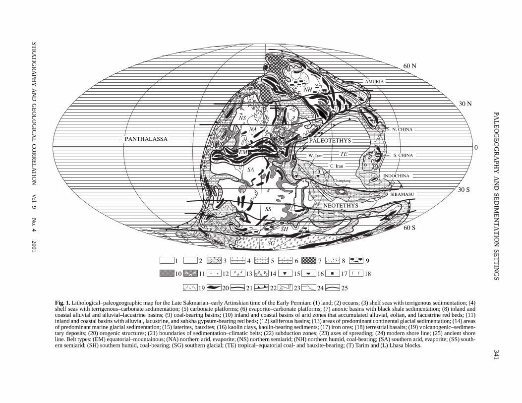
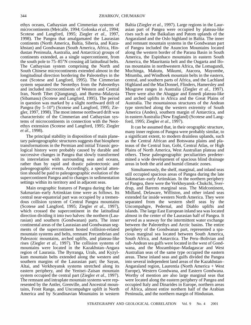
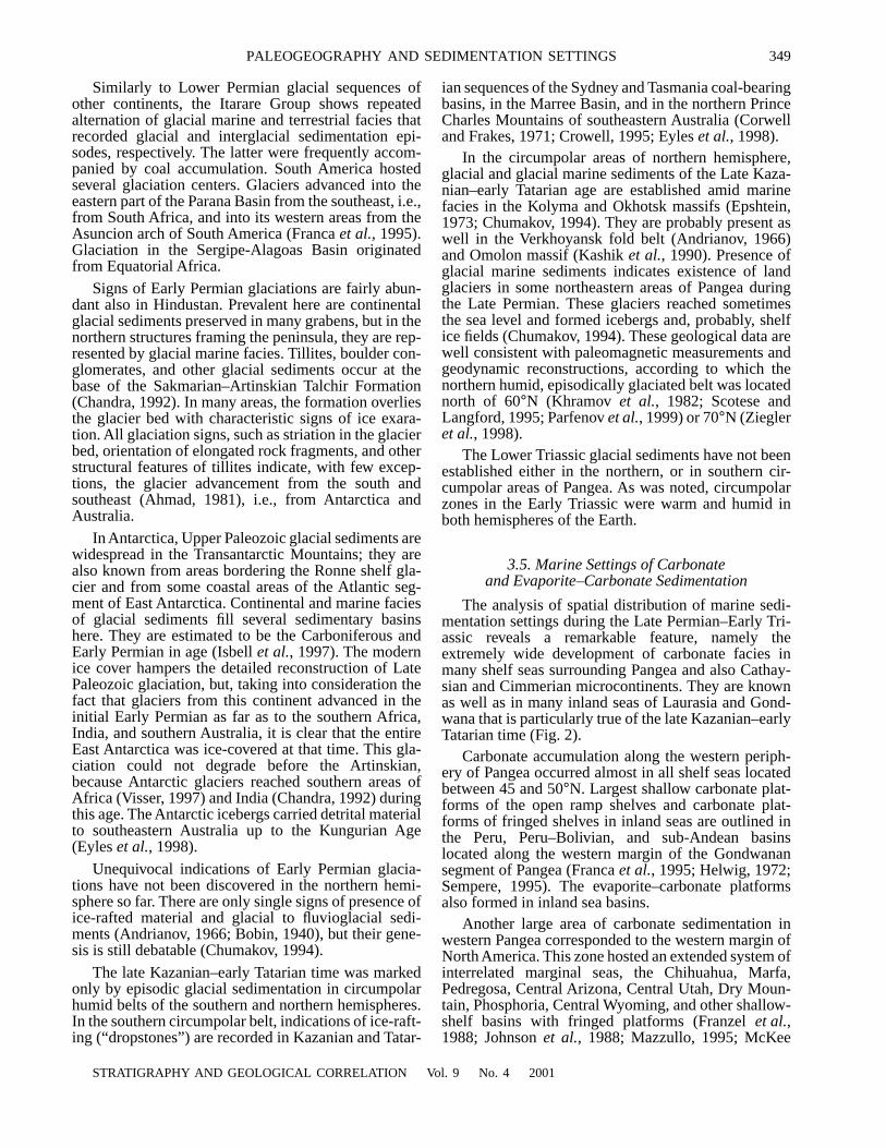
Fig. 1.
Lithological–paleogeographic map for the Late Sakmarian–early Artinskian time of the Early Permian: (1) land; (2) oceans; (3) shelf seas with terrigenous sedimentation; (4)shelf seas with terrigenous–carbonate sedimentation; (5) carbonate platforms; (6) evaporite–carbonate platforms; (7) anoxic basins with black shale sedimentation; (8) inland andcoastal alluvial and alluvial–lacustrine basins; (9) coal-bearing basins; (10) inland and coastal basins of arid zones that accumulated alluvial, eolian, and lacustrine red beds; (11)inland and coastal basins with alluvial, lacustrine, and sabkha gypsum-bearing red beds; (12) saliferous basins; (13) areas of predominant continental glacial sedimentation; (14) areasof predominant marine glacial sedimentation; (15) laterites, bauxites; (16) kaolin clays, kaolin-bearing sediments; (17) iron ores; (18) terrestrial basalts; (19) volcanogenic–sedimen-tary deposits; (20) orogenic structures; (21) boundaries of sedimentation–climatic belts; (22) subduction zones; (23) axes of spreading; (24) modern shore line; (25) ancient shoreline. Belt types: (EM) equatorial–mountainous; (NA) northern arid, evaporite; (NS) northern semiarid; (NH) northern humid, coal-bearing; (SA) southern arid, evaporite; (SS) south-ern semiarid; (SH) southern humid, coal-bearing; (SG) southern glacial; (TE) tropical–equatorial coal- and bauxite-bearing; (T) Tarim and (L) Lhasa blocks.
aaaaaaaaaaaaaaaaaaaaaaaaaaaaaaaaaaaaaaaaaaaaaaaaaaaaaaaaaaaaaaaaaaaaaaaaaaaaaaaaaaaaaaaaaaaaaaaaaaaaaaaaaaaaaaaaaaaaaaaaaaaaaaaaaaaaaaaaaaaaaaaaaaaaaaaaaaaaaaaaaaaaa
PANTHALASSA PALEOTETHYS
W. Iran
TE
C. Iran
Changtang
NH
NS
NA
SA
EM
í
NEOTETHYS
SIBAMASU
INDOCHINA
S. CHINA
N. CHINA
AMURIA
0
30 N
30 S
60 S
SS
SH
Laaaaaa
1 2 3 4 5 6 7 8 9
10 11 12 13 14 15 16 17 18
19 20 21 22 23 24 25
SG
60 N

342
STR
AT
IGR
APH
Y A
ND
GE
OL
OG
ICA
L C
OR
RE
LA
TIO
N
Vol. 9
No. 4
2001
ZH
AR
KO
V, C
HU
MA
KO
V
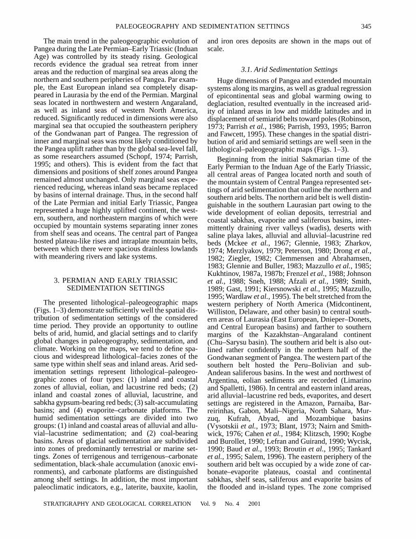
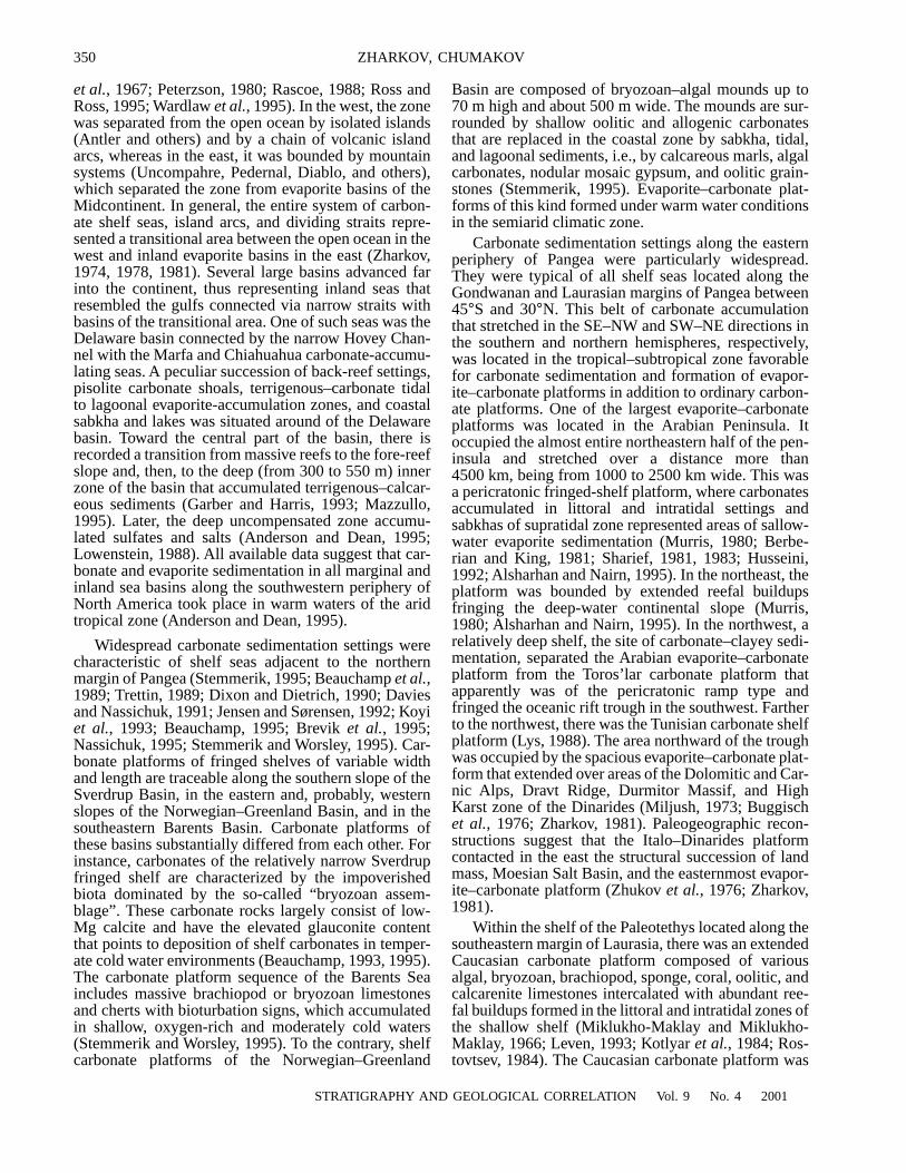
Fig. 2.
Lithological–paleogeographic map for the Late Kazanian–early Tatarian time of the Late Permian (symbols as in Fig. 1).
aaaaaaaaaaaaaaaaaaaaaaaaaaaaaaaaaaaaaaaaaaaaaaaaaaaaaaaaaaaaaaaaaaaaaaaaaaaaaaaaaaaaaaaaaaaaaaaaaaaaaaaaaaaaaaaaaaaaaaaaaaaaaaaaaaaaaaaaaaaaaaaaaaaaaaaaaaaaaaaaaaaaaaaaaaaaaaaaaaaaaaaaaaaaaa
PANTHALASSA
NEOTETHYS
PALEOTETHYS
60 N
30 N
0
30 S
60 S
W. Iran
C. Iran
Changtang
SIBAMASU
INDOCHINA
S. CHINA
N. CHINA
AMURIA
í
L
SA
NA
NS
NH
TE
SS
SH
EM

STR
AT
IGR
APH
Y A
ND
GE
OL
OG
ICA
L C
OR
RE
LA
TIO
N
Vol. 9
No. 4
2001
PAL
EO
GE
OG
RA
PHY
AN
D SE
DIM
EN
TA
TIO
N SE
TT
ING
S343
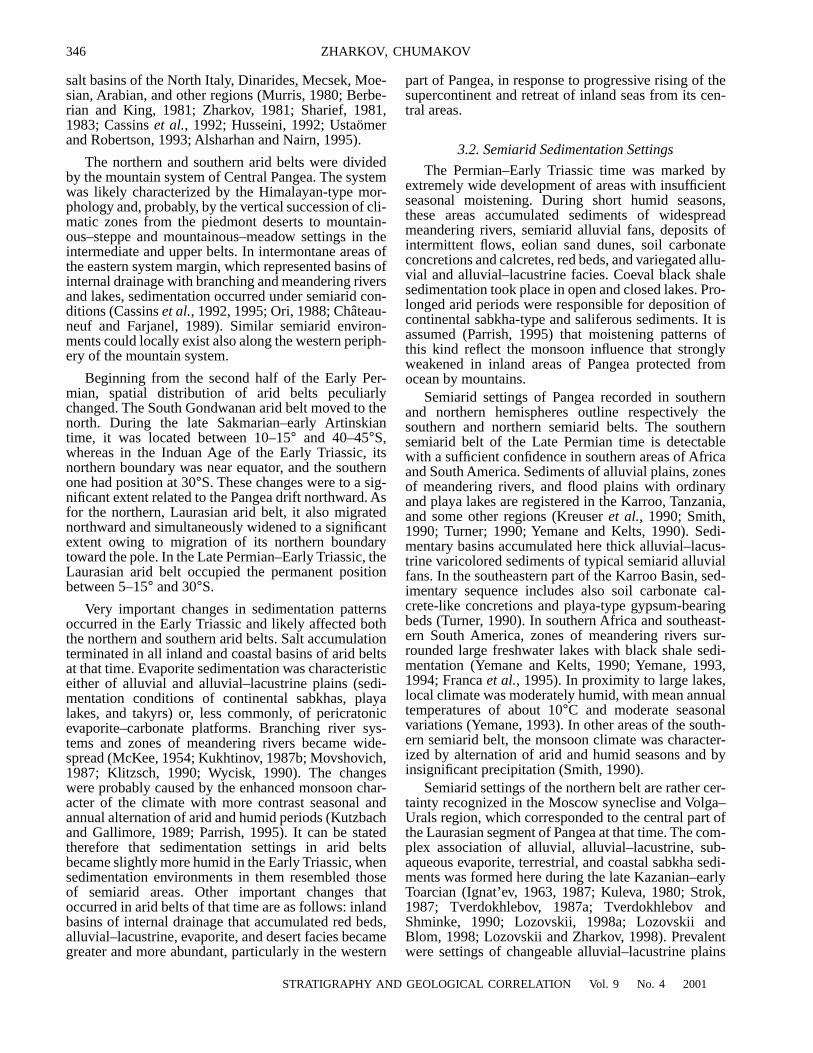
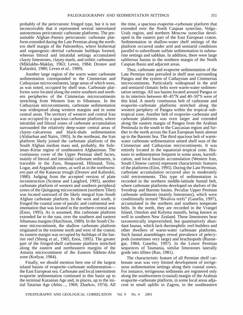
Fig. 3.
Lithological–paleogeographic map for the Induan Age of the Early Triassic (symbols as in Fig. 1).
aaaaaaaaaaaaaaaaaaaaaaaaaaaaaaaaaaaaaaaaaaaaaaaaaaaaaaaaaaaaaaaaaaaaaaaaaaaaaaaaaaaaaaaaaaaaaaaaaaaaaaaaaaaaaaaaaaaaaaaaaaaaaaaaa a aaaaaaaaaaaaaaaaaaaaaaaaaaaaaa a aaaaaaaaaaa aaa aaaaa aaaaaaaaaaaaaaaaaaaaaaaaaaaaaaaaaaaaaaaaaaaaa aaaaaaaaaaaaaaaaaaaaaaaaaa
PANTHALASSA
SA
SS
SH
EM
NA
NH
NS
PALEOTETHYS
60 N
TE
W. Iran
C. Iran
NEOTETHYS
30 N
0
30 S
60 S
Changtang
SIBAMASU
INDOCHINA
S. CHINA
N. CHINA
AMURIA
344
STRATIGRAPHY AND GEOLOGICAL CORRELATION
Vol. 9
No. 4
2001
ZHARKOV, CHUMAKOV
ethys oceans, Cathaysian and Cimmerian systems ofmicrocontinents (Metcalfe, 1994; Golonka
et al.
, 1994;Scotese and Langford, 1995; Ziegler
et al.
, 1997,1998). The Pangea that amalgamated the Laurasiancontinents (North America, Baltia, Siberia, and Kaza-khstan) and Gondwanan (South America, Africa, Hin-dustan Peninsula, Australia, and Antarctica) groups ofcontinents extended, as a single supercontinent, fromthe south pole to 75–85
°
N crossing all latitudinal belts.The Cathaysian system comprising the North andSouth Chinese microcontinents extended almost in thelongitudinal direction bordering the Paleotethys in theeast (Scotese and Langford, 1995). The Cimmeriansystem separated the Neotethys from the Paleotethysand included microcontinents of Western and CentralIran, North Tibet (Qiangtang), and Burma–Malaysia(Sibamasu) (Scotese and Langford, 1995). The periodin question was marked by a slight northward drift ofPangea (by 5–10
°
) (Scotese and Langford, 1995; Zie-gler, 1997, 1998). The most intense northward drift wascharacteristic of the Cimmerian and Cathaysian sys-tems of microcontinents in connection with the Neot-ethys extension (Scotese and Langford, 1995; Ziegler
et al.
, 1998).The principal stability in disposition of main plane-
tary paleogeographic structures suggests that biospheretransformations in the Permian and initial Triassic geo-logical history were probably caused by durable andsuccessive changes in Pangea that slowly transformedits interrelation with surrounding seas and oceans,rather than by rapid and drastic paleotectonic andpaleogeographic events. Accordingly, a special atten-tion should be paid to paleogeographic evolution of thesupercontinent Pangea and to changes in sedimentationsettings within its territory and in adjacent seas.
Main orographic features of Pangea during the lateSakmarian–early Artinskian time were as follows. Itscentral near-equatorial part was occupied by a tremen-dous collision system of Central Pangea mountains(Scotese and Langford, 1995; Ziegler
et al.
, 1997),which crossed the supercontinent in the latitudinaldirection dividing it into two halves: the northern (Lau-rasian) and southern (Gondwanan) parts. The innercontinental areas of the Laurasian and Gondwanan seg-ments of the supercontinent hosted collision-relatedmountain systems and belts, remnant Precambrian andPaleozoic mountains, arched uplifts, and plateau-likerises (Ziegler
et al.
, 1997). The collision systems ofmountains were located in the Kazakhstan–Angararegion of Laurasia. The Byrranga, Urals, and Kyzyl-kum mountain belts extended along the western andsouthern margins of the Laurasian part; the Sayan,Altai, and Verkhoyansk systems stretched along itseastern periphery, and the Yenisei–Zaisan mountainsystem occupied the central part (Ziegler
et al.
, 1997).The remnant and intraplate mountain systems were rep-resented by the Antler, Grenville, and Ancestral moun-tains, Front Range, and Uncompahgre uplift in NorthAmerica and by Scandinavian Mountains in western
Baltia (Ziegler
et al.
, 1997). Large regions in the Laur-asian part of Pangea were occupied by plateau-likerises such as the Baikalian and Patom uplands of theAngaraland and the Oslo highland in Baltia. The innerand remnant mountain systems in the Gondwanan partof Pangea included the Asuncion Mountains locatedalong the western border of the Parana Basin in SouthAmerica, the Espinhaco mountains in eastern SouthAmerica, the Mauritania belt and the Ougarta and Ifo-ras mountains in northwestern Africa, the Lomagundi,Muchinga, Makutu, Mikumi, Atacora, Mayombe,Mitumba, and Windhoek mountain belts in the eastern,central, and southern parts of Africa, and the LachlandHighland and the MacDonnel, Flinders, Hamersley andMusgrave ranges in Australia (Ziegler
et al.
, 1997).There were also the Ahaggar and Ennedi plateau-likeand arched uplifts in Africa and the Great Plains ofAustralia. The mountainous structures of the Andeantype stretched along the western extremity of SouthAmerica (Andes), southern margin of Antarctica, andin eastern Australia (New England) (Scotese and Lang-ford, 1995; Ziegler
et al.
, 1997).It can be assumed that, in their orographic structure,
many inner regions of Pangea were probably similar, toa significant extent, to modern drainless uplands, suchas the Central African and Botswana plains and pla-teaus of the Central Iran, Gobi, Central Atlas, or HighPlains of North America, West Australian plateau andothers. These paleogeographic peculiarities predeter-mined a wide development of spacious blind drainageareas in both the arid and humid climatic zones.
Simultaneously, the shelf, marginal, and inland seasstill occupied spacious areas of Pangea during the lateSakmarian–early Artinskian. In the northern peripheryof Pangea, there were the Verkhoyansk–Chukchi, Sver-drup, and Barents marginal seas. The Midcontinent,Midland, Delaware, Williston, and other inland seasextended far inside western North America. They wereseparated from the western shelf seas by theUncompahgre, Pedernal, and Diablo uplifts andislands. The large East European inland sea was locatedalmost in the center of the Laurasian half of Pangea. Itserved as a seaway for the intermittent water exchangebetween the Paleotethys and Arctic basins. The entireperiphery of the Gondwanan part, represented a spa-cious marginal sea located between South America,South Africa, and Antarctica. The Peru–Bolivian andsub-Andean sea gulfs were located in the west of Gond-wana, and the Mozambique–Madagascar and WestAustralian seas of the same type occupied the easternareas. These inland seas and gulfs divided the Pangeainto several independent land areas of the Kazakhstan–Angaraland region, Laurentia (North America + WestEurope), Western Gondwana, and Eastern Gondwana.Worthy of mention are also large marginal seas thatwere located along the eastern periphery of Pangea andoccupied Italy and Dinarides in Europe, northern areasof Africa, almost entire northern half of the ArabianPeninsula, and the northern margin of Hindustan.
STRATIGRAPHY AND GEOLOGICAL CORRELATION
Vol. 9
No. 4
2001
PALEOGEOGRAPHY AND SEDIMENTATION SETTINGS 345
The main trend in the paleogeographic evolution ofPangea during the Late Permian–Early Triassic (InduanAge) was controlled by its steady rising. Geologicalrecords evidence the gradual sea retreat from innerareas and the reduction of marginal sea areas along thenorthern and southern peripheries of Pangea. Par exam-ple, the East European inland sea completely disap-peared in Laurasia by the end of the Permian. Marginalseas located in northwestern and western Angaraland,as well as inland seas of western North America,reduced. Significantly reduced in dimensions were alsomarginal sea that occupied the southeastern peripheryof the Gondwanan part of Pangea. The regression ofinner and marginal seas was most likely conditioned bythe Pangea uplift rather than by the global sea-level fall,as some researchers assumed (Schopf, 1974; Parrish,1995; and others). This is evident from the fact thatdimensions and positions of shelf zones around Pangearemained almost unchanged. Only marginal seas expe-rienced reducing, whereas inland seas became replacedby basins of internal drainage. Thus, in the second halfof the Late Permian and initial Early Triassic, Pangearepresented a huge highly uplifted continent, the west-ern, southern, and northeastern margins of which wereoccupied by mountain systems separating inner zonesfrom shelf seas and oceans. The central part of Pangeahosted plateau-like rises and intraplate mountain belts,between which there were spacious drainless lowlandswith meandering rivers and lake systems.
3. PERMIAN AND EARLY TRIASSIC SEDIMENTATION SETTINGS
The presented lithological–paleogeographic maps(Figs. 1–3) demonstrate sufficiently well the spatial dis-tribution of sedimentation settings of the consideredtime period. They provide an opportunity to outlinebelts of arid, humid, and glacial settings and to clarifyglobal changes in paleogeography, sedimentation, andclimate. Working on the maps, we tend to define spa-cious and widespread lithological–facies zones of thesame type within shelf seas and inland areas. Arid sed-imentation settings represent lithological–paleogeo-graphic zones of four types: (1) inland and coastalzones of alluvial, eolian, and lacustrine red beds; (2)inland and coastal zones of alluvial, lacustrine, andsabkha gypsum-bearing red beds; (3) salt-accumulatingbasins; and (4) evaporite–carbonate platforms. Thehumid sedimentation settings are divided into twogroups: (1) inland and coastal areas of alluvial and allu-vial–lacustrine sedimentation; and (2) coal-bearingbasins. Areas of glacial sedimentation are subdividedinto zones of predominantly terrestrial or marine set-tings. Zones of terrigenous and terrigenous–carbonatesedimentation, black-shale accumulation (anoxic envi-ronments), and carbonate platforms are distinguishedamong shelf settings. In addition, the most importantpaleoclimatic indicators, e.g., laterite, bauxite, kaolin,
and iron ores deposits are shown in the maps out ofscale.
3.1. Arid Sedimentation Settings
Huge dimensions of Pangea and extended mountainsystems along its margins, as well as gradual regressionof epicontinental seas and global warming owing todeglaciation, resulted eventually in the increased arid-ity of inland areas in low and middle latitudes and indisplacement of semiarid belts toward poles (Robinson,1973; Parrish
et al.
, 1986; Parrish, 1993, 1995; Barronand Fawcett, 1995). These changes in the spatial distri-bution of arid and semiarid settings are well seen in thelithological–paleogeographic maps (Figs. 1–3).
Beginning from the initial Sakmarian time of theEarly Permian to the Induan Age of the Early Triassic,all central areas of Pangea located north and south ofthe mountain system of Central Pangea represented set-tings of arid sedimentation that outline the northern andsouthern arid belts. The northern arid belt is well distin-guishable in the southern Laurasian part owing to thewide development of eolian deposits, terrestrial andcoastal sabkhas, evaporite and saliferous basins, inter-mittently draining river valleys (wadis), deserts withsaline playa lakes, alluvial and alluvial–lacustrine redbeds (Mckee
et al.
, 1967; Glennie, 1983; Zharkov,1974; Merzlyakov, 1979; Peterson, 1980; Drong
et al.
,1982; Ziegler, 1982; Clemmensen and Abrahamsen,1983; Glennie and Buller, 1983; Mazzullo
et al.
, 1985;Kukhtinov, 1987a, 1987b; Frenzel
et al.
, 1988; Johnson
et al.
, 1988; Sneh, 1988; Afzali
et al.
, 1989; Smith,1989; Gast, 1991; Kiersnowski
et al.
, 1995; Mazzullo,1995; Wardlaw
et al.
, 1995). The belt stretched from thewestern periphery of North America (Midcontinent,Williston, Delaware, and other basin) to central south-ern areas of Laurasia (East European, Dnieper–Donets,and Central European basins) and farther to southernmargins of the Kazakhstan–Angaraland continent(Chu–Sarysu basin). The southern arid belt is also out-lined rather confidently in the northern half of theGondwanan segment of Pangea. The western part of thesouthern belt hosted the Peru–Bolivian and sub-Andean saliferous basins. In the west and northwest ofArgentina, eolian sediments are recorded (Limarinoand Spalletti, 1986). In central and eastern inland areas,arid alluvial–lacustrine red beds, evaporites, and desertsettings are registered in the Amazon, Parnaiba, Bar-reirinhas, Gabon, Mali–Nigeria, North Sahara, Mur-zuq, Kufrah, Abyad, and Mozambique basins(Vysotskii
et al.
, 1973; Blant, 1973; Nairn and Smith-wick, 1976; Cahen
et al.
, 1984; Klitzsch, 1990; Kogbeand Burollet, 1990; Lefran and Guirand, 1990; Wycisk,1990; Baud
et al.
, 1993; Broutin
et al.
, 1995; Tankard
et al.
, 1995; Salem, 1996). The eastern periphery of thesouthern arid belt was occupied by a wide zone of car-bonate–evaporite plateaus, coastal and continentalsabkhas, shelf seas, saliferous and evaporite basins ofthe flooded and in-island types. The zone comprised
346
STRATIGRAPHY AND GEOLOGICAL CORRELATION
Vol. 9
No. 4
2001
ZHARKOV, CHUMAKOV
salt basins of the North Italy, Dinarides, Mecsek, Moe-sian, Arabian, and other regions (Murris, 1980; Berbe-rian and King, 1981; Zharkov, 1981; Sharief, 1981,1983; Cassins
et al.
, 1992; Husseini, 1992; Ustaömerand Robertson, 1993; Alsharhan and Nairn, 1995).
The northern and southern arid belts were dividedby the mountain system of Central Pangea. The systemwas likely characterized by the Himalayan-type mor-phology and, probably, by the vertical succession of cli-matic zones from the piedmont deserts to mountain-ous–steppe and mountainous–meadow settings in theintermediate and upper belts. In intermontane areas ofthe eastern system margin, which represented basins ofinternal drainage with branching and meandering riversand lakes, sedimentation occurred under semiarid con-ditions (Cassins
et al.
, 1992, 1995; Ori, 1988; Château-neuf and Farjanel, 1989). Similar semiarid environ-ments could locally exist also along the western periph-ery of the mountain system.
Beginning from the second half of the Early Per-mian, spatial distribution of arid belts peculiarlychanged. The South Gondwanan arid belt moved to thenorth. During the late Sakmarian–early Artinskiantime, it was located between 10–15
°
and 40–45
°
S,whereas in the Induan Age of the Early Triassic, itsnorthern boundary was near equator, and the southernone had position at 30
°
S. These changes were to a sig-nificant extent related to the Pangea drift northward. Asfor the northern, Laurasian arid belt, it also migratednorthward and simultaneously widened to a significantextent owing to migration of its northern boundarytoward the pole. In the Late Permian–Early Triassic, theLaurasian arid belt occupied the permanent positionbetween 5–15
°
and 30
°
S.
Very important changes in sedimentation patternsoccurred in the Early Triassic and likely affected boththe northern and southern arid belts. Salt accumulationterminated in all inland and coastal basins of arid beltsat that time. Evaporite sedimentation was characteristiceither of alluvial and alluvial–lacustrine plains (sedi-mentation conditions of continental sabkhas, playalakes, and takyrs) or, less commonly, of pericratonicevaporite–carbonate platforms. Branching river sys-tems and zones of meandering rivers became wide-spread (McKee, 1954; Kukhtinov, 1987b; Movshovich,1987; Klitzsch, 1990; Wycisk, 1990). The changeswere probably caused by the enhanced monsoon char-acter of the climate with more contrast seasonal andannual alternation of arid and humid periods (Kutzbachand Gallimore, 1989; Parrish, 1995). It can be statedtherefore that sedimentation settings in arid beltsbecame slightly more humid in the Early Triassic, whensedimentation environments in them resembled thoseof semiarid areas. Other important changes thatoccurred in arid belts of that time are as follows: inlandbasins of internal drainage that accumulated red beds,alluvial–lacustrine, evaporite, and desert facies becamegreater and more abundant, particularly in the western
part of Pangea, in response to progressive rising of thesupercontinent and retreat of inland seas from its cen-tral areas.
3.2. Semiarid Sedimentation Settings
The Permian–Early Triassic time was marked byextremely wide development of areas with insufficientseasonal moistening. During short humid seasons,these areas accumulated sediments of widespreadmeandering rivers, semiarid alluvial fans, deposits ofintermittent flows, eolian sand dunes, soil carbonateconcretions and calcretes, red beds, and variegated allu-vial and alluvial–lacustrine facies. Coeval black shalesedimentation took place in open and closed lakes. Pro-longed arid periods were responsible for deposition ofcontinental sabkha-type and saliferous sediments. It isassumed (Parrish, 1995) that moistening patterns ofthis kind reflect the monsoon influence that stronglyweakened in inland areas of Pangea protected fromocean by mountains.
Semiarid settings of Pangea recorded in southernand northern hemispheres outline respectively thesouthern and northern semiarid belts. The southernsemiarid belt of the Late Permian time is detectablewith a sufficient confidence in southern areas of Africaand South America. Sediments of alluvial plains, zonesof meandering rivers, and flood plains with ordinaryand playa lakes are registered in the Karroo, Tanzania,and some other regions (Kreuser
et al.
, 1990; Smith,1990; Turner; 1990; Yemane and Kelts, 1990). Sedi-mentary basins accumulated here thick alluvial–lacus-trine varicolored sediments of typical semiarid alluvialfans. In the southeastern part of the Karroo Basin, sed-imentary sequence includes also soil carbonate cal-crete-like concretions and playa-type gypsum-bearingbeds (Turner, 1990). In southern Africa and southeast-ern South America, zones of meandering rivers sur-rounded large freshwater lakes with black shale sedi-mentation (Yemane and Kelts, 1990; Yemane, 1993,1994; Franca
et al.
, 1995). In proximity to large lakes,local climate was moderately humid, with mean annualtemperatures of about 10
°
C and moderate seasonalvariations (Yemane, 1993). In other areas of the south-ern semiarid belt, the monsoon climate was character-ized by alternation of arid and humid seasons and byinsignificant precipitation (Smith, 1990).
Semiarid settings of the northern belt are rather cer-tainty recognized in the Moscow syneclise and Volga–Urals region, which corresponded to the central part ofthe Laurasian segment of Pangea at that time. The com-plex association of alluvial, alluvial–lacustrine, sub-aqueous evaporite, terrestrial, and coastal sabkha sedi-ments was formed here during the late Kazanian–earlyToarcian (Ignat’ev, 1963, 1987; Kuleva, 1980; Strok,1987; Tverdokhlebov, 1987a; Tverdokhlebov andShminke, 1990; Lozovskii, 1998a; Lozovskii andBlom, 1998; Lozovskii and Zharkov, 1998). Prevalentwere settings of changeable alluvial–lacustrine plains
STRATIGRAPHY AND GEOLOGICAL CORRELATION
Vol. 9
No. 4
2001
PALEOGEOGRAPHY AND SEDIMENTATION SETTINGS 347
with seasonal sedimentation cycles, sedimentationbreaks, soil and caliche formation, and gypsum accu-mulation in playas and sabkhas. Periodically wide-spread were branching river systems and probablezones of meandering rivers farther from the prove-nance. Features of the humid climate become wellmanifested by the end of the Permian (Ignat’ev, 1987;Strok, 1987; Tverdokhlebov, 1987a). Another area ofthe semiarid sedimentation located in the northern beltis recognizable in the southern Chu–Sarysu depressionof the Kazakhstan–Angaraland continent. Terrestrialalluvial–lacustrine, floodplain, and sabkha sedimentsare represented here by red beds, variegated facies, andsaliferous sequences with interbeds of the Na-Ca-sul-fate composition (glauberite) indicating alternation ofwarm humid, arid, and cold seasons. Eolian sedimenta-tion probably developed as well. The winter tempera-tures could vary from –5 to –15
°
C, whereas summertemperatures could be as high as +20–+30
°
C (Zherebt-sova, 1977). In general, the northern semiarid belt ofthe early Late Permian time extended in between 25–30
°
N and 35–40
°
N.In the terminal Late Permian–Early Triassic, the
semiarid belts gradually widened in both the southernand northern hemispheres mainly owing to migrationof high-latitude boundaries toward the relevant poles.The southern boundary of the southern semiarid beltwas located in the Early Triassic at about 70–75
°
S. Thisbelt covered the greater part of Australia, where semi-arid settings of alluvial–lacustrine red beds are regis-tered in the Bowen, Maryborough, Springfield, andTasmania basins (Brown
et al.
, 1970; Veevers, 1984).The northern boundary of the northern semiarid beltwas located in the Early Triassic between 65 and 70
°
N.It covered northern Cisuralian regions of the East Euro-pean platform, and also southern and central areas ofAngaraland. In the Pechora, Korotaikha, Bol’shayaSynya, Kos’yu–Rogovo, Kuznetsk, Gorlovo, Dzhungarbasins, and in western areas of the Verkhoyansk basinof the belt, prevalent were alluvial and alluvial–lacus-trine settings that accumulated red and varicoloreddeposits of semiarid sedimentation (Chelyshev, 1972;Dagys
et al.
, 1979; Kalantar, 1987; Neustroeva andBogomazov, 1987; Lozovskii and Balabanov,1988).The northern semiarid belt included also theTarim, North Chinese, and Amuria microcontinentswith red beds, fluvial and varicolored freshwater-lacus-trine sediments widespread in the Kuqa, North Chi-nese, Khanka, and other basins (Kotlyar, 1984; WangHongzhen, 1985; Durante, 1998; Lozovskii, 1998b).
Thus, semiarid conditions spread in Pangea duringthe Late Permian–Early Triassic over spacious areas inmiddle and high latitudes of both hemispheres. Theprevalent sedimentation settings allow their belts oftheir development to be referred to as “semiarid allu-vial–lacustrine” ones. The northern semiarid belt of theEarly Triassic time occupied areas between 30 and 65–70
°
N. The southern, comparatively wide semiarid beltstretched between 30 and 70–75
°
S. As is seen, both
belts were located symmetrically relative to equator. Bythe beginning of the Triassic, sedimentation settingsturned out to be more or less uniform over the entirePangea supercontinent. This is evident from disappear-ance of cold belts and also from widened belts of semi-arid alluvial–lacustrine sedimentation and a slighthumidity increase in arid belts.
3.3. Humid Sedimentation Settings
Humid sedimentation settings and correspondingbelts are distinguished, with some degree of certainty,only for the Permian time. They are recognizable bydistribution patterns of coal-bearing basins and gray-colored alluvial, alluvial–lacustrine, boggy, and flood-plain sediments. The available data allow the northernand southern Permian humid belts to be outlined inPangea (Fig. 1, 2).
In the northern belt, continental and coastal humidsettings were widespread in Angaraland and the north-ern Aral region, where the Tunguska, Kuznetsk, Gor-lovo, Pechora, and other coal-bearing basins are known(
Atlas…
, 1968; Chelyshev, 1972; Bogomazov
et al.
,1984; Meyen and Golubeva, 1984; Yuzvitskii
et al.
,1984; Gurevich, 1987; Betekhtina
et al.
, 1988; Duranteand Mogucheva, 1998). In the late Sakmarian–earlyArtinskian time, the humid coal-bearing belt coveredthe entire northern margin of Pangea northward of 30–40
°
N. In the late Kazanian–early Toarcian time, the beltoccupied the same areas of Angaraland and Cis-Uralsnorthward of 40–45
°
N. Its northern part is known tohost glacial marine and seasonal ice sediments (Chu-makov, 1994).
The southern humid belt of coal accumulation waslocated in the late Sakmarian–early Artinskian between50–55 and 70–75
°
S. It included the Karroo, Ruhuhu,Luangua, and other basins in southern Africa, theSokoto Basin in western Madagascar, the Damodar,Jharia, Mahanadi, Satpura. and other basins in the Hin-dustan, and the Bowen Basin in eastern Australia(Ahmad, 1964; Brown et al., 1970; Kreuser andSemkiwa, 1987; Cook, 1990; Kreuser et al., 1990;Smith, 1990; Turner, 1990; Mishra, 1991; Mitra, 1991;Langford, 1992). In the Late Permian, the belt coveredalmost the whole area of East Gondwana, includingAustralia and Antarctica, and was located south of 55–60°S. In Africa, humid environments were preservedonly at its southern extremity, where the Jugella Ferry-Vryheid coal-bearing basin was located (Yemane andKelts, 1990). In Hindustan, the belt included the above-mentioned coal-bearing basins. The entire southeasternpart of Australia with Bowen, Denison, Sydney, Tasma-nia, Marree, and other coal-bearing basins was also apart of the belt (Langford, 1992). Some coal-bearingbasins (Sydney, Tasmania, Marree) enclose glacialmarine and continental sediments of the Late Permian(Kazanian) age (Caputo and Crowell, 1985; Langford,1992; Crowell, 1995; Eyles et al., 1998). This suggests

348
STRATIGRAPHY AND GEOLOGICAL CORRELATION Vol. 9 No. 4 2001
ZHARKOV, CHUMAKOV
that intermittent glaciers appeared in the southernhumid coal-bearing belt.
During the period under consideration, other set-tings of humid sedimentation existed in the Cathaysianand Cimmerian microcontinents and in marginalcoastal areas of Pangea. They outline the equatorialhumid zone of coal- and bauxite-bearing deposits.Coal-bearing basins with alluvial, alluvial–lacustrine,alluvial–floodplain, and boggy sediments are knownwithin this zone in the North Chinese, Amuria, Tarim,South Chinese, and Quingtang microcontinents and inthe Quidam, Qinling, and Songpan-Ganzi terranes(Kotlyar, 1984; Lee, 1984, 1985a, 1986b; Ulmishek,1984; Sheng et al., 1985; Wang Hongzhen, 1985; YangZunyi et al., 1986; Enos, 1995; Durante, 1998). Baux-ite-bearing sequences are registered in the North Chi-nese, South Chinese, Indochina, and Western Iranmicrocontinents, as well as in the Caucasian and Pam-irs margins of Pangea (Leven, 1984; Enos, 1995).
In the Early Triassic, coal accumulation ceased overthe entire territory of Pangea, and in Cathaysian andCimmerian microcontinents. The humid belts of theEarly Triassic time are distinguishable only in circum-polar zones of northern and southern hemispheres,judging from gray-colored rocks prevailing insequences of the marginal areas of Angaraland andAntarctica (Dagys et al., 1979; Sadovnikov and Orlova,1997; Retablak, 1999).
Thus, it can be postulated that the Late Permian–Early Triassic history was associated with severalimportant changes in the humid belts. First, settingsfavorable for coal accumulation disappeared in theEarly Triassic everywhere, including the humid belts aswell. Second, the semiarid sedimentation graduallyreplaced the humid one, thus reducing the distributionarea of the latter. Third, the humid belts migratedtoward the poles. All these changes were apparentlyrelated to global warming and growing aridity of theclimate.
3.4. Glacial Sedimentation Settings
As was mentioned, most significant biosphere trans-formations commenced, when Late Paleozoic glacia-tions degraded in the Sakmarian Age of the Early Per-mian.
Most researchers believe that the peak of the EarlyPermian glaciation was in the Asselian–Sakmariantime (Visser, 1996; Crowell, 1995). At that time, glacialsheets covered high and middle latitudes of SouthAmerica, Africa (southern Arabia and Madagascarincluded), India, Tibet, and Australia. That glaciationlikely affected also the Malacca–Burma terrane. Ant-arctica was apparently covered by ice completely. Theglacial belt was sometimes as wide as 45–50°. In thesecontinents, ice shields and mountainous glaciers leftabundant exaration signs (striated glacier bed with allcharacteristic structures, trough valleys, fjords), basal
tillites, fluvioglacial, lacustrine–glacial, and glacialmarine sediments. The latter are particularly wide-spread. The glacial marine sediments, which accumu-lated under influence of shelf glaciers, snowmelt run-off, and icebergs, were more or less reworked by under-water colluviation. In the late Sakmarian–initialArtinskian, glaciers began to retreat everywhere, andthe glacial belt significantly narrowed. Its northernboundary moved close to the Southern Polar Circle(Fig. 1).
The Karroo, Kalahari, and Karasburg basins ofSouth Africa accumulated the thick Early Permiansequence of glacial sediments (the upper part of theDwyka Group). Along periphery of these basins and ondividing rises, the sequence is composed of terrestrialglacial sediments, whereas in their central and south-eastern parts, it is mainly represented by glacial marinedeposits. The last signs of ice rafting in South Africaare registered in the lower part of the Prince Albert For-mation corresponding to the base of the Ecca Grouppresumably of Artinskian age.
In Australia, the Early Permian glacial sedimentsare preserved in many sedimentary basins between Tas-mania in the south and Bonaparte Bay in the north,where they are traceable from the western to easterncoasts of the continent. Many researchers believe thatPermian glaciations commenced there during the Sak-marian Age and, reducing in dimensions, continued toexist with breaks during the Artinskian, Kungurian, andto Kazanian ages (Crowell and Frakes, 1971), or eventill the Ufimian Age (Eyles et al., 1998). Other authorsestimated that glaciation in Australia lasted from theAsselian to early Sakmarian, and that no shield glacia-tion occurred there after this period (Dickins, 1996;Lindsay, 1997).
The most important glaciation centers were locatedin the western, central, and southern parts of Australia(Lindsay, 1997), and apparently in the Great ArtesianBasin (Frakes, 1979). A thick ice sheet covered moun-tainous areas in the eastern coast of Australia. Struc-tures observed in the glacial beds and tillites indicatethat coastal glaciers of southern Australia moved fromthe southeast, i.e., from Antarctica, to the northwest(Lindsay, 1997; Bourman and Alley, 1999). The ice-rafted material occurring in southeastern Australiacould also be delivered mostly from Antarctica (Eyleset al., 1998).
In South America, Lower Permian glacial depositsare recorded in several basins located south of 10°S(modern coordinates). The largest of them is the ParanaBasin of southern Brazil. Upper Paleozoic glacial sedi-ments are distinguished here as the Itarare Group, thelarger upper part of which is referred to the Lower Per-mian, although its age is debatable. Some researcherssuggest the Asselian–Sakmarian or Asselian–Artin-skian age of the group (Franca et al., 1995), but othersrefer it to uppermost layers to the Kungurian Stage.
STRATIGRAPHY AND GEOLOGICAL CORRELATION Vol. 9 No. 4 2001
PALEOGEOGRAPHY AND SEDIMENTATION SETTINGS 349
Similarly to Lower Permian glacial sequences ofother continents, the Itarare Group shows repeatedalternation of glacial marine and terrestrial facies thatrecorded glacial and interglacial sedimentation epi-sodes, respectively. The latter were frequently accom-panied by coal accumulation. South America hostedseveral glaciation centers. Glaciers advanced into theeastern part of the Parana Basin from the southeast, i.e.,from South Africa, and into its western areas from theAsuncion arch of South America (Franca et al., 1995).Glaciation in the Sergipe-Alagoas Basin originatedfrom Equatorial Africa.
Signs of Early Permian glaciations are fairly abun-dant also in Hindustan. Prevalent here are continentalglacial sediments preserved in many grabens, but in thenorthern structures framing the peninsula, they are rep-resented by glacial marine facies. Tillites, boulder con-glomerates, and other glacial sediments occur at thebase of the Sakmarian–Artinskian Talchir Formation(Chandra, 1992). In many areas, the formation overliesthe glacier bed with characteristic signs of ice exara-tion. All glaciation signs, such as striation in the glacierbed, orientation of elongated rock fragments, and otherstructural features of tillites indicate, with few excep-tions, the glacier advancement from the south andsoutheast (Ahmad, 1981), i.e., from Antarctica andAustralia.
In Antarctica, Upper Paleozoic glacial sediments arewidespread in the Transantarctic Mountains; they arealso known from areas bordering the Ronne shelf gla-cier and from some coastal areas of the Atlantic seg-ment of East Antarctica. Continental and marine faciesof glacial sediments fill several sedimentary basinshere. They are estimated to be the Carboniferous andEarly Permian in age (Isbell et al., 1997). The modernice cover hampers the detailed reconstruction of LatePaleozoic glaciation, but, taking into consideration thefact that glaciers from this continent advanced in theinitial Early Permian as far as to the southern Africa,India, and southern Australia, it is clear that the entireEast Antarctica was ice-covered at that time. This gla-ciation could not degrade before the Artinskian,because Antarctic glaciers reached southern areas ofAfrica (Visser, 1997) and India (Chandra, 1992) duringthis age. The Antarctic icebergs carried detrital materialto southeastern Australia up to the Kungurian Age(Eyles et al., 1998).
Unequivocal indications of Early Permian glacia-tions have not been discovered in the northern hemi-sphere so far. There are only single signs of presence ofice-rafted material and glacial to fluvioglacial sedi-ments (Andrianov, 1966; Bobin, 1940), but their gene-sis is still debatable (Chumakov, 1994).
The late Kazanian–early Tatarian time was markedonly by episodic glacial sedimentation in circumpolarhumid belts of the southern and northern hemispheres.In the southern circumpolar belt, indications of ice-raft-ing (“dropstones”) are recorded in Kazanian and Tatar-
ian sequences of the Sydney and Tasmania coal-bearingbasins, in the Marree Basin, and in the northern PrinceCharles Mountains of southeastern Australia (Corwelland Frakes, 1971; Crowell, 1995; Eyles et al., 1998).
In the circumpolar areas of northern hemisphere,glacial and glacial marine sediments of the Late Kaza-nian–early Tatarian age are established amid marinefacies in the Kolyma and Okhotsk massifs (Epshtein,1973; Chumakov, 1994). They are probably present aswell in the Verkhoyansk fold belt (Andrianov, 1966)and Omolon massif (Kashik et al., 1990). Presence ofglacial marine sediments indicates existence of landglaciers in some northeastern areas of Pangea duringthe Late Permian. These glaciers reached sometimesthe sea level and formed icebergs and, probably, shelfice fields (Chumakov, 1994). These geological data arewell consistent with paleomagnetic measurements andgeodynamic reconstructions, according to which thenorthern humid, episodically glaciated belt was locatednorth of 60°N (Khramov et al., 1982; Scotese andLangford, 1995; Parfenov et al., 1999) or 70°N (Ziegleret al., 1998).
The Lower Triassic glacial sediments have not beenestablished either in the northern, or in southern cir-cumpolar areas of Pangea. As was noted, circumpolarzones in the Early Triassic were warm and humid inboth hemispheres of the Earth.
3.5. Marine Settings of Carbonate and Evaporite–Carbonate Sedimentation
The analysis of spatial distribution of marine sedi-mentation settings during the Late Permian–Early Tri-assic reveals a remarkable feature, namely theextremely wide development of carbonate facies inmany shelf seas surrounding Pangea and also Cathay-sian and Cimmerian microcontinents. They are knownas well as in many inland seas of Laurasia and Gond-wana that is particularly true of the late Kazanian–earlyTatarian time (Fig. 2).
Carbonate accumulation along the western periph-ery of Pangea occurred almost in all shelf seas locatedbetween 45 and 50°N. Largest shallow carbonate plat-forms of the open ramp shelves and carbonate plat-forms of fringed shelves in inland seas are outlined inthe Peru, Peru–Bolivian, and sub-Andean basinslocated along the western margin of the Gondwanansegment of Pangea (Franca et al., 1995; Helwig, 1972;Sempere, 1995). The evaporite–carbonate platformsalso formed in inland sea basins.
Another large area of carbonate sedimentation inwestern Pangea corresponded to the western margin ofNorth America. This zone hosted an extended system ofinterrelated marginal seas, the Chihuahua, Marfa,Pedregosa, Central Arizona, Central Utah, Dry Moun-tain, Phosphoria, Central Wyoming, and other shallow-shelf basins with fringed platforms (Franzel et al.,1988; Johnson et al., 1988; Mazzullo, 1995; McKee
350
STRATIGRAPHY AND GEOLOGICAL CORRELATION Vol. 9 No. 4 2001
ZHARKOV, CHUMAKOV
et al., 1967; Peterzson, 1980; Rascoe, 1988; Ross andRoss, 1995; Wardlaw et al., 1995). In the west, the zonewas separated from the open ocean by isolated islands(Antler and others) and by a chain of volcanic islandarcs, whereas in the east, it was bounded by mountainsystems (Uncompahre, Pedernal, Diablo, and others),which separated the zone from evaporite basins of theMidcontinent. In general, the entire system of carbon-ate shelf seas, island arcs, and dividing straits repre-sented a transitional area between the open ocean in thewest and inland evaporite basins in the east (Zharkov,1974, 1978, 1981). Several large basins advanced farinto the continent, thus representing inland seas thatresembled the gulfs connected via narrow straits withbasins of the transitional area. One of such seas was theDelaware basin connected by the narrow Hovey Chan-nel with the Marfa and Chiahuahua carbonate-accumu-lating seas. A peculiar succession of back-reef settings,pisolite carbonate shoals, terrigenous–carbonate tidalto lagoonal evaporite-accumulation zones, and coastalsabkha and lakes was situated around of the Delawarebasin. Toward the central part of the basin, there isrecorded a transition from massive reefs to the fore-reefslope and, then, to the deep (from 300 to 550 m) innerzone of the basin that accumulated terrigenous–calcar-eous sediments (Garber and Harris, 1993; Mazzullo,1995). Later, the deep uncompensated zone accumu-lated sulfates and salts (Anderson and Dean, 1995;Lowenstein, 1988). All available data suggest that car-bonate and evaporite sedimentation in all marginal andinland sea basins along the southwestern periphery ofNorth America took place in warm waters of the aridtropical zone (Anderson and Dean, 1995).
Widespread carbonate sedimentation settings werecharacteristic of shelf seas adjacent to the northernmargin of Pangea (Stemmerik, 1995; Beauchamp et al.,1989; Trettin, 1989; Dixon and Dietrich, 1990; Daviesand Nassichuk, 1991; Jensen and Sørensen, 1992; Koyiet al., 1993; Beauchamp, 1995; Brevik et al., 1995;Nassichuk, 1995; Stemmerik and Worsley, 1995). Car-bonate platforms of fringed shelves of variable widthand length are traceable along the southern slope of theSverdrup Basin, in the eastern and, probably, westernslopes of the Norwegian–Greenland Basin, and in thesoutheastern Barents Basin. Carbonate platforms ofthese basins substantially differed from each other. Forinstance, carbonates of the relatively narrow Sverdrupfringed shelf are characterized by the impoverishedbiota dominated by the so-called “bryozoan assem-blage”. These carbonate rocks largely consist of low-Mg calcite and have the elevated glauconite contentthat points to deposition of shelf carbonates in temper-ate cold water environments (Beauchamp, 1993, 1995).The carbonate platform sequence of the Barents Seaincludes massive brachiopod or bryozoan limestonesand cherts with bioturbation signs, which accumulatedin shallow, oxygen-rich and moderately cold waters(Stemmerik and Worsley, 1995). To the contrary, shelfcarbonate platforms of the Norwegian–Greenland
Basin are composed of bryozoan–algal mounds up to70 m high and about 500 m wide. The mounds are sur-rounded by shallow oolitic and allogenic carbonatesthat are replaced in the coastal zone by sabkha, tidal,and lagoonal sediments, i.e., by calcareous marls, algalcarbonates, nodular mosaic gypsum, and oolitic grain-stones (Stemmerik, 1995). Evaporite–carbonate plat-forms of this kind formed under warm water conditionsin the semiarid climatic zone.
Carbonate sedimentation settings along the easternperiphery of Pangea were particularly widespread.They were typical of all shelf seas located along theGondwanan and Laurasian margins of Pangea between45°S and 30°N. This belt of carbonate accumulationthat stretched in the SE–NW and SW–NE directions inthe southern and northern hemispheres, respectively,was located in the tropical–subtropical zone favorablefor carbonate sedimentation and formation of evapor-ite–carbonate platforms in addition to ordinary carbon-ate platforms. One of the largest evaporite–carbonateplatforms was located in the Arabian Peninsula. Itoccupied the almost entire northeastern half of the pen-insula and stretched over a distance more than4500 km, being from 1000 to 2500 km wide. This wasa pericratonic fringed-shelf platform, where carbonatesaccumulated in littoral and intratidal settings andsabkhas of supratidal zone represented areas of sallow-water evaporite sedimentation (Murris, 1980; Berbe-rian and King, 1981; Sharief, 1981, 1983; Husseini,1992; Alsharhan and Nairn, 1995). In the northeast, theplatform was bounded by extended reefal buildupsfringing the deep-water continental slope (Murris,1980; Alsharhan and Nairn, 1995). In the northwest, arelatively deep shelf, the site of carbonate–clayey sedi-mentation, separated the Arabian evaporite–carbonateplatform from the Toros’lar carbonate platform thatapparently was of the pericratonic ramp type andfringed the oceanic rift trough in the southwest. Fartherto the northwest, there was the Tunisian carbonate shelfplatform (Lys, 1988). The area northward of the troughwas occupied by the spacious evaporite–carbonate plat-form that extended over areas of the Dolomitic and Car-nic Alps, Dravt Ridge, Durmitor Massif, and HighKarst zone of the Dinarides (Miljush, 1973; Buggischet al., 1976; Zharkov, 1981). Paleogeographic recon-structions suggest that the Italo–Dinarides platformcontacted in the east the structural succession of landmass, Moesian Salt Basin, and the easternmost evapor-ite–carbonate platform (Zhukov et al., 1976; Zharkov,1981).
Within the shelf of the Paleotethys located along thesoutheastern margin of Laurasia, there was an extendedCaucasian carbonate platform composed of variousalgal, bryozoan, brachiopod, sponge, coral, oolitic, andcalcarenite limestones intercalated with abundant ree-fal buildups formed in the littoral and intratidal zones ofthe shallow shelf (Miklukho-Maklay and Miklukho-Maklay, 1966; Leven, 1993; Kotlyar et al., 1984; Ros-tovtsev, 1984). The Caucasian carbonate platform was
STRATIGRAPHY AND GEOLOGICAL CORRELATION Vol. 9 No. 4 2001
PALEOGEOGRAPHY AND SEDIMENTATION SETTINGS 351
probably of the pericratonic fringed type, but it is notinconceivable that it represented several interrelatedautonomous pericratonic carbonate platforms. The pre-sumable Afghan–Pamirs pericratonic carbonate plat-form extended during the Late Permian along the north-ern shelf margin of the Paleotethys, where biohermaland organogenic–detrital carbonate buildups formed,whereas littoral and intratidal settings accumulatedclayey limestones, clayey marls, and oolitic carbonates(Miklukho-Maklay, 1963; Leven, 1984; Dronov andKafarskii, 1980; Leven et al., 1989).
Another large region of the warm water carbonatesedimentation corresponded to the Cimmerian andCathaysian microcontinents, large areas of which were,as was noted, occupied by shelf seas. Carbonate plat-forms were located along the entire southern and north-ern peripheries of the Cimmerian microcontinentsstretching from Western Iran to Sibamasu. In theCathaysian microcontinents, carbonate sedimentationwas widespread along western margins and in somecentral areas. The territory of western and central Iranwas occupied by a spacious carbonate platform, whereintratidal and littoral zones of carbonate accumulationsurrounded the relatively deep-water central areas ofclayey–calcareous and black-shale sedimentation(Alsharhan and Nairn, 1995). In the northeast, the Iranplatform likely joined the carbonate platform of theSouth Afghan median mass and, probably, the Sule-iman–Kirtar region of southeastern Afghanistan. Thecontinuous cover of the Upper Permian shelf facies,mainly of littoral and intratidal carbonate sediments, istraceable in the Zuru, Huspasrud, Hilmand, Tirin,Logar, and Argandab zones, as well as in the northwest-ern part of the Katawaz trough (Dronov and Kafarskii,1980). Judging from the accepted version of platereconstruction (Scotese and Langford, 1995), anothercarbonate platform of western and southern peripheralzones of the Quingtang microcontinent (northern Tibet)was located eastward of the likely integral Iran–SouthAfghan carbonate platform. In the west and south, itfringed the coastal zone of paralic and continental sed-imentation that was located in the northern central area(Enos, 1995). As is assumed, this carbonate platformextended far to the east, over the southern and easternSibamasu margins (Hutchison, 1989). In the South Chi-nese microcontinent, the shallow carbonate platformoriginated in the extreme north and west of the craton;its eastern margin was occupied by buildups of the bar-rier reef (Sheng et al., 1985; Enos, 1995). The greaterpart of the fringed-shelf carbonate platform stretchedalong the eastern and northeastern margins of theAmuria microcontinent of the Eastern Sikhote-Alinzone (Kotlyar, 1984).
Finally, we should mention here one of the largestinland basins of evaporite–carbonate sedimentation—the East European sea. Carbonate and local intermittentevaporite sedimentation continued in this basin up tothe terminal Kazanian Age and, in places, up to the ini-tial Tatarian Age (Atlas…, 1969; Zharkov, 1974). All
the time, a spacious evaporite–carbonate platform thatextended over the North Caspian syneclise, Volga–Urals region, and northern Moscow syneclise devel-oped in the eastern part of the East European craton.Sedimentation in shallow-water shelf settings of theplatform occurred under arid and semiarid conditionsparallel to subordinate sulfate sedimentation in subma-rine settings and sabkhas. In addition, there were largesaliferous basins in the northern margin of the NorthCaspian Basin and adjacent areas.
Thus, carbonate and evaporite sedimentation of theLate Permian time prevailed in shelf seas surroundingPangea and the system of Cathaysian and Cimmerianmicrocontinents. Particularly widespread in the aridand semiarid climatic belts were warm-water sedimen-tation settings. All sea basins located around Pangea orin its interiors between 40–45°N and 40–50°S were ofthis kind. A nearly continuous belt of carbonate andevaporite–carbonate platforms stretched along thewestern periphery of Pangea within the tropical–sub-tropical zone. Another belt of evaporite–carbonate andcarbonate platforms was even larger and extendedalong the eastern margin of Pangea from the ArabianPeninsula in the south to the Caucasian region and fur-ther to the north across the East European basin almostup to the Barents Sea. The third spacious belt of warm-water carbonate sedimentation united shelf seas of theCimmerian and Cathaysian microcontinents. It wasentirely located in the equatorial–tropical zone. Hia-tuses in sedimentation frequent in some areas, karstifi-cation, and local bauxite accumulation (Western Iran,South Chinese carton) represent characteristic featuresof the platforms (Elon, 1995). During the Late Permian,carbonate accumulation occurred also in moderatelycold environments. This type of sedimentation isrecorded in the northern middle-latitude humid belt,where carbonate platforms developed on shelves of theSverdrup and Barents basins. Peculiar Upper Permiancarbonate sediments (mainly limestones), which wereconditionally termed “Bivalvia reefs” (Ganelin, 1997),accumulated in the northern and southern temperatebelts. In the north, they are recorded in the VrangelIsland, Omolon and Kolyma massifs, being known aswell in southern New Zealand. These limestones beartaxonomically impoverished, but quantitatively abun-dant faunas, which lack thermophilic reef-builders andother dwellers of warm-water carbonate platforms.Such faunal assemblages reveal prevalence of pelecy-pods (sometimes very large) and brachiopods (Runne-gar, 1984; Ganelin, 1997). In the Lower Permiansequences of Tasmania, similar limestones laterallygrade into tillites (Rao, 1981).
The characteristic feature of all Permian shelf car-bonate seas was very limited development of terrige-nous sedimentation settings along their coastal zones.For instance, terrigenous sediments are registered onlyalong the southwestern (coastal) margin of the Arabianevaporite–carbonate platform, in some local areas adja-cent to small uplifts in Zagros, in the southeastern
352
STRATIGRAPHY AND GEOLOGICAL CORRELATION Vol. 9 No. 4 2001
ZHARKOV, CHUMAKOV
Toros’lar region, and in the west of Arabian Peninsula(Alsharhan and Nairn, 1995). Narrow sandy shoals andbeaches, or sabkha-type supratidal zones relativelysmall in extension are recognizable around many otherscarbonate and evaporite–carbonate platforms confinedto western and eastern margins of Pangea. As is estab-lished in the Capitan shelf of the Delaware Basin,where zone of sabkha facies is up to several dozenskilometers wide (Garber and Harris, 1993; Mazzullo,1995), even in the case of a wide zone with coastalsabkhas and intermittently drained lakes (playas), ter-rigenous sedimentation was of minor importance. Prev-alent in this case were mosaic gypsum-bearing rocksalternating with dolomites. Along their coast-facingmargins, the carbonate platforms of the Cimmerian ter-ranes were bounded by very narrow zones of detritalsediments, as it is well exemplified by the Iran–SouthAfghan platform. Littoral terrigenous facies were rela-tively widespread only around the Khamdian Oldlandof the South Chinese microcontinent at the beginningof the Tatarian Age (Enos, 1995). Similar, very narrowcoastal zones of shelf terrigenous sedimentation areassumed to be the deposition sites of fine-grained sand-stones in the fringe carbonate platforms of the Sverdrupand Barents basins (Beauchamp, 1995; Stemmerik andWorsley, 1995). Terrigenous sediments of coastal zonesare recorded only along the Uralian margin of the EastEuropean Basin (Chuvashov, 1995).
The Early Triassic was marked by a significantreduction of shelf carbonate accumulation, particularlyalong the northern and western margins of Pangea,where spacious terrigenous shelves appeared. Never-theless, the principal distribution patterns of carbonateplatforms remained unchanged.
Limited development of coastal detrital sedimentsin most shelf carbonate seas indicates that carbonateand evaporite–carbonate platforms along lowland mar-gins of Pangea and microcontinents of the Cathaysianand Cimmerian systems were located close to desertareas of the arid and semiarid climatic zones, as it isevident from presence of eolian sediments and dunesthere. In the humid zones, carbonate platforms werelocated near boggy coasts with rare meandering rivers.Thus, the carbonate platforms blocked somehow thelowland margins of Pangea, and this indicates thatprevalent in this supercontinent were paleogeographicenvironments of internal, but not external drainage.
3.6. Black Shale Sedimentation Settings
During the late Early Permian and in the Late Per-mian–Early Triassic, anoxic settings favorable forblack shale sedimentation were characteristic of manyshelf seas and inland lakes. They are recorded in all cli-matic belts.
Sufficiently wide development of cold to moder-ately cold anoxic setting of black shale sedimentation isestablished for shelf seas of the northern Pangea mar-
gin. In the late Sakmarian–early Artinskian and lateKazanian–early Tatarian periods, there was a zone ofinterrelated black shale basins that extended from thenorthern margin of Alaska to the eastern coast of theBarents Sea. The zone included the Sverdrup, Wandel,Björnöya, Hammerfest, Nordcap, Northeastern Spits-bergen, and, probably, northern Novaya Zemlya basins(Beauchamp, 1995; Stemmerik and Worsley, 1995).Deep inner areas of these basins were characterized bystagnant anoxic sedimentation environments. In theSverdrup Basin, accumulation of spongolites occurredfirst parallel to prograding clinoform filling of deep-water zones and draining of separate areas of fringedcarbonate platform that was characterized by succes-sive accumulation of spicule-bearing clayey mud, inter-beds and lenses of carbonates and glauconite-bearingsands, and then by predominant deposition of spong-olites in the cold-water environments (Beauchamp,1995). In the Wandel, Björnöya, Hammerfest, Nordcap,and Northeastern Spitsbergen, prevalent at that timewas also sedimentation in the deep-water stagnant set-tings. The indicated basins accumulated siliceous spi-culite shales with bioturbation signs in their centraldeep areas and dark gray clayey mud with thin inter-beds of bioclastic carbonates (packstones and wacke-stones) in shallower shelf areas near adjacent carbonateplatforms (Stemmerik and Worsley, 1995).
North of the Sverdrup–Barents zone of black shalesedimentation, there was the large Verkhoyansk–Chuk-chi basin with anoxic sedimentation environments.Boundaries of the latter can be established very arbi-trarily on the basis of isolated and scattered distributionareas of black shales in the Kolyma–Chukchi andVerkhoyansk regions, and in islands of the ArcticOcean (Epshtein, 1973; Ganelin, 1984a, 1984b, 1984c,1984d, 1997; Ustritskii, 1984, 1993; Kashik et al.,1990). In the Vrangel Is., the corresponding sequence iscomposed of laminated to varved micritic limestonesemanating H2S, black shales, and varicolored shaleswith siliceous–manganese concretions (Ganelin, 1997).In the southern Yana–Kolyma region, prevalent areblack massive and laminated rock sequences of shaleand siltstone–shale composition, which accumulatedunder calm stagnant hydrodynamic conditions in innerzones of the past sea basin (Epshtein, 1973). In general,cold-water and moderately cold-water deep settings ofblack shale sedimentation were characteristic of manybasins located along the northern margin of Pangea inthe middle-latitude humid and circumpolar, episodi-cally glacial climatic belts.
Warm-water anoxic settings of black shale sedimen-tation are registered in several sea basins of subtropicaland tropical belts. They are presumed for the Phospho-ria, Chihuahua, and some other basins in the southwest-ern periphery of the North American margin of Pangea,where black shale sedimentation continued probablyuntil the Kazanian Age (Sheldon et al., 1967; Etten-sohn, 1994; Woods et al., 1991). Along the easternperiphery of Pangea, anoxic conditions were intermit-
STRATIGRAPHY AND GEOLOGICAL CORRELATION Vol. 9 No. 4 2001
PALEOGEOGRAPHY AND SEDIMENTATION SETTINGS 353
tently restored in many areas of the Arabian and Ital-ian–Dinarides evaporite–carbonate platforms(Zharkov, 1981; Alsharhan and Nairn, 1995). In thesoutheastern Laurasian segment of Pangea and adjacentnorthwestern margin of the Tarim microcontinent, con-ditions favorable for black shale sedimentation existedfor a long time in the North Tarim Basin (Enos, 1995).Another region with anoxic sedimentation environ-ments corresponded to central and northeastern areas ofthe Central Iranian microcontinent, where blackmicritic bituminous limestones, black marls, and shaleswith cherty lenses and concretions accumulated in rel-atively deep-water inner areas of the carbonate plat-form (Geological…, 1977; Sharief, 1981, 1983; Hus-seini, 1992; Alsharhan and Nairn, 1995). It should benoted that all mentioned areas and basins of warm-water black shale sedimentation were confined to shal-low shelf zones of seas located either close to evaporitebasins or directly within evaporite–carbonate plat-forms.
Widespread, particularly since the Kazanian Age,became also lacustrine settings of black shale sedimen-tation. As was mentioned, an extended belt of spaciousfreshwater lakes stretched along the southern margin ofWestern Gondwana occupying significant areas ofSouth America and South Africa (Padula, 1969;Yemane and Kelts, 1990; Yemane, 1993, 1994; Francaet al., 1995). A large lake basin with black shale sedi-mentation presumably existed in the Turgai lowland ofthe southern Angaraland–Kazakhstan area of Laurasia(Atlas…, 1968).
In the Early Triassic, basins with black shale sedi-mentation were less common. In the northern margin ofPangea, there remained only the Sverdrup–Barentsbasin and another small basin in the Chukchi Peninsula(Dagys et al., 1979; Trettin, 1989; Wignall and Hallam,1992; Ettensohn, 1994; Wignall and Twitchett, 1996).The North Italian basin also continued to exist (Wignalland Hallam, 1992; Wignall and Twitchett, 1996). Anew basin with black shale sedimentation appeared inthe Cis-Himalayas zone of Hindustan (Kapoor andTokuoka, 1985). In addition, the deep Early Triassicbasin with black shale sedimentation extended alongcontinental slopes of the Amuria and North Chinesemicrocontinents (Isazaki, 1994; Bragin, 2000).
It seems that several types of basins with anoxicblack shale sedimentation can de distinguished. Thefirst group includes the deep shelf basins located inmarginal seas that surrounded Pangea. The Sverdrup–Barents and Kolyma–Chukchi basins can be referred tothis type. Basins of the second group, such as the Cis-Himalayas and Central Iranian basins of black shalesedimentation, were situated in inner, deeper zones ofcarbonate platforms. Anoxic basins of the third typeoccupied an intermediate position between the salifer-ous and evaporite basins, on the one hand, and the shelfzones of carbonate accumulation, on the other. Thistype can be exemplified by the Phosphoria, Chihuahua,
North Italian, North Tarim, and some other basins.Finally, inland lake basins with black shale sedimenta-tion represent the fourth type.
It is noteworthy that many basins with black shalesedimentation were located close to zones of evaporiteaccumulation and to coeval or earlier saliferous basinsof the Permian time. As is known (Zharkov et al.,1979), deep areas of evaporite basins accumulate largeamounts of highly concentrated brines, which later canenter the shelf zones and intermediate basins withgroundwater runoff. The subsurface migration of heavysalty brines into subsided areas of shelves or deepbasins of marginal seas resulted in water stratificationand created stagnant conditions favorable for accumu-lation of sediments with the elevated content of organicmatter. These conditions could stimulate formation ofanoxic environments in the Sverdrup, Barents, Phos-phoria, Chihuahua, North Italian, North Tarim, EastEuropean, Central European, Arabian, and otherbasins. The Kolyma–Chukchi, Barents, and Sverdrupbasins were also characterized by the intermittent ther-mal stratification of water mass. Spatial distributionpatterns of most basins with black shale sedimentationindicate that influx of oxygen-free waters from oceanwas hardly responsible for appearance of stagnant envi-ronments in shelf and marginal seas, as is assumed bysome researchers (Hallam, 1994; Wignall and Hallam,1992, 1996; Knoll et al., 1996; Wignall and Twitchet,1996). The available data suggest that most basins withblack shale sedimentation formed likely owing to eitherthe influx of highly concentrated brines from evaporitebasins that have been located along the Pangea margin,or to the groundwater runoff from the supercontinent.In general, it can be assumed that the groundwater run-off from Pangea during the entire period of its highstand in the Late Permian–Early Triassic could signifi-cantly influence surrounding shelf seas.
3.7. Marine Settings of Terrigenous Sedimentation
The remarkable feature of the Permian time is a rel-atively limited distribution of seas with terrigenous sed-imentation around Pangea and also around Cimmerianand Cathaysian microcontinents. More or less signifi-cant shallow-water and, particularly, deep-water terrig-enous sedimentation commenced only in some seabasins during the Kazanian Age of the Late Permian. Itwas usually confined either to circumpolar regions ofthe northern and southern hemispheres, or to easternmargins of Pangea and Cathaysian microcontinents.
The spacious region of marine terrigenous sedimen-tation extended over the North Alaskan, Yukon, NovayaZemlya, Verkhoyansk–Okhotsk, and Kolyma–Omolonprovinces in the northern Pangea margin (Ganelin,1984a, 1984b, 1984c; Ustritskii, 1984, 1993; Chern-yak, 1984; Kashik et al., 1990; Beauchamp, 1995; Pov-ysheva and Ustritskii, 1996; Sadovnikov and Orlova,1997). The North Alaskan shallow-water terrigenousshelf was a deposition area of glauconite sandstones,
354
STRATIGRAPHY AND GEOLOGICAL CORRELATION Vol. 9 No. 4 2001
ZHARKOV, CHUMAKOV
limy argillites, and clayey limestones, which accumu-lated in coastal and inner shelf zones, sometimes understorm-wave influence (Beauchamp, 1995). The NovayaZemlya terrigenous shelf of the Kazanian–Tatariantime accumulated an intricately alternating sequence ofsandstones, siltstones, and argillites mainly in tidal and,probably, in proximal–distal zones of inner and outershelves, where hydrodynamics was highly active.Coastal marine sediments of the Verkhoyansk regionare frequently represented by sandstones. They likelyaccumulated in the intertidal zone under influence oftidal currents and storm waves. The terrigenous shelf ofthe Kolyma–Omolon region was characterized appar-ently by shallow-water tidal and wave hydrodynamicsthat is evident from alternation of glauconite sandstone,siliceous–clayey glauconite limestone, and coquinalayers. As a rule, shallow terrigenous shelves of theNorth Alaskan, Yukon, Taimyr, and Kolyma–Omolonregions were relatively narrow in the Late Permian timeand fringed deep inner zones of marginal sea basinswith stagnant anoxic environments.
One more large region with shallow-water terrige-nous shelf sedimentation is outlined in the northeasternperiphery of Pangea along the Mongolian margin ofPanthalassa (Shipulina, 1959; Zonenshain et al., 1990).A thick sandstone–shale sequence of this region likelyaccumulated in the inner and outer shelf zones and,probably, on the continental slope in the course of tur-bidite sedimentation.
Two other regions with terrigenous marine sedimen-tation were confined to active continental margins. Oneof them was located in southeastern areas of the SouthChinese microcontinent, and the second one corre-sponded to the New Zealand margin of the Gondwanansegment of Pangea. As is inferred (Hsü et al., 1990), theSouth Chinese region represented during the Late Per-mian a deep piedmont trough that accumulated terrige-nous turbidites and molasses, being situated along thenorthern margin of the Hunan microcontinent; the latterseparated from the Yangtze platform by the openingNanpanjiang ocean. It is assumed that the Late Permianrising and erosion of the Hunan active margin and adja-cent island arcs gave rise to accumulation of flyschoiddeposits and conglomerates in the deep-water trough.The narrow and shallow terrigenous shelf is also out-lined along the southern passive margin of the Hunanmicrocontinent that faced the Gunanhai ocean.1 TheNew Zealand region was characterized by accumula-tion of thick terrigenous, mainly green- or gray-coloredsandy–clayey sediments. They accumulated on shallowshelves and in deep troughs along island arcs (Brownet al., 1970; Steven and Speden, 1978; Veevers, 1984).
Relatively narrow terrigenous shelves are assumedto have been existed also along the western periphery of
1 In our lithological–paleogeographic maps based on geodynamicreconstructions by Scotese and Langford (1995), the Hunanmicrocontinent, as well as the Nanpanjiang and Hunanhai oceansare not indicated.
Pangea. An extended system of subduction-related oro-genic structures and volcanic island arcs is outlinedhere. It stretched from the western margins of Canadaand the United States (Nicola, Huntington, Hallavah,Klamath and other island arcs) to southern margins ofSouth America and western Antarctica (the Andeansubduction zone, Patagonia island arc, and others).These arcs could have shallow terrigenous shelves(Scotese and Langford, 1995). Nevertheless, no deeptroughs with the thick Upper Permian turbiditesequence are established there.
It should be noted again that the terrigenous seashelves of the Late Permian time were significantlysmaller in dimensions and less widespread than shelfsettings of carbonate sedimentation. This proportionremains valid in general for the Early Triassic timedespite the larger dimensions of shelf areas with terrig-enous sedimentation of that time, particularly in thenorthern and western margins of Pangea.
4. MAIN TRENDS IN EVOLUTION OF SEDIMENTATION–CLIMATIC ZONING
The analyzed spatial distribution of latitudinal beltswith arid, semiarid, humid, and glacial sedimentationshows that the period from the late Sakmarian Age ofthe Early Permian to the Indian Age of the Early Trias-sic was marked by gradual widening of the arid andsemiarid belts and by contrast lowering in the globalsedimentation–climatic zoning.
The latitudinal asymmetry of climatic and sedimen-tation zones was most significant in the late Sakmar-ian–early Artinskian time. One glacial belt comprisedat that time all circumpolar areas of the southern hemi-sphere located south of 60–75°S. The northern andsouthern coal-bearing belts were asymmetricallylocated relative to equator. The southern humid beltwas comparatively narrow and stretched between 50–55 and 60–75°S. Some its areas experienced intermit-tent glaciations. The northern humid coal-bearing belt,unlike the southern one, was sufficiently wide, coveringall Pangea regions located north of 30–40°N. Distinctlyasymmetrical was location of semiarid and arid belts.These belts extended almost up to 50–55°S in thesouthern hemisphere and up to 30–40°N in the northernhemisphere.
In the late Kazanian–early Tatarian period, sedi-mentation belts of Pangea were more symmetrical inthe southern and northern hemispheres. The equatorialmountainous belt retained its central position. Regionslocated to the south and north of it were occupied byarid and semiarid belts. Middle and high latitudes inboth hemispheres corresponded to humid coal-bearingbelts; small glaciation centers appeared episodically intheir circumpolar areas. Simultaneously, some asym-metry in position of sedimentation–climatic belts con-tinued to exist. For instance, the arid and semiarid beltswere of different width and had different positions rel-
STRATIGRAPHY AND GEOLOGICAL CORRELATION Vol. 9 No. 4 2001
PALEOGEOGRAPHY AND SEDIMENTATION SETTINGS 355
ative to equator. The arid belt of the southern hemi-sphere extended almost up to 35–40°S, whereas in thenorthern hemisphere, its counterpart was limited by lat-itude of 30°S. The southern semiarid belt, which waslocated between 35–40 and 50–60°S, was substantiallywider and closer to the pole. The northern semiarid beltstretched between 30 and 40°N. A similar migrationtoward the pole is also registered for the southernhumid coal-bearing belt. The asymmetric location ofbelts could be a consequence of the asymmetrical posi-tion of continental blocks and seas in circumpolarzones of the Earth relative to equator. A large continen-tal block of East Pangea was located in southern highlatitudes, whereas the land areas in northern circumpo-lar zone were much lesser and surrounded by seas. Inthe late Kazanian–early Tatarian time, the asymmetrywas even more pronounced, because the large regionsof the Laurasian segment of Pangea were still occupiedby spacious inland and shelf seas.
The terminal Permian and initial Early Triassic wereperiods of less contrast latitudinal sedimentation zon-ing in Pangea, where the almost ideal symmetry rela-tive to equator characterized positions of belts witharid, semiarid, and humid sedimentation. The belts ofarid evaporite sedimentation were located between30°S and 30°N. The semiarid alluvial–lacustrine beltsextended between 30 and 65–70°N in the northernhemisphere and between 30 and 75°S in the southernhemisphere. The circumpolar zones of both hemi-spheres corresponded to the humid sedimentation belts.Prevalent in Pangea became settings of arid and semi-arid sedimentation. As a result, basins of internal drain-age with prevalent arid evaporite and semiarid alluvial–lacustrine sedimentation multiplied and became largerin the inner areas of Pangea by the end of the Permian.
5. GLOBAL EXCHANGE OF MATTER BETWEEN LAND AND OCEANS
DURING PERMIAN–TRIASSIC BIOSPHERE TRANSFORMATIONS
Data discussed in previous sections indicate thatmost important paleogeographic changes of the LatePermian–Early Triassic time were the degradation ofglacial belts and the gradual uplift of Pangea responsi-ble for regression of inner and marginal seas. Theseevents resulted in global warming, widened belts ofarid and semiarid sedimentation settings, and increasedareas and number of basins of internal drainage. Simul-taneously, settings of humid sedimentation became lesswidespread that caused the gradual reduction of surfi-cial runoff and displacement of terrigenous depositioncenters from marginal to inner areas of Pangea.
In this connection, we should point to a significantdisproportion between intensities of terrigenous sedi-mentation in terrestrial and marine settings, and alsobetween volumes of carbonate and terrigenous sedi-ments accumulated in the Late Permian. Even approxi-mate estimates indicate that the intensity of continental
terrigenous sedimentation in the second half of the LatePermian was about an order higher than that of marineterrigenous sedimentation. Simultaneously, the inten-sity of accumulation of carbonate sediments was 1.5–2times higher than that of marine terrigenous deposits.In the Cretaceous, for instance, the proportion wasopposite, and the carbonate/terrigenous sediment ratiowas approximately 1 : 2 (Ronov, 1980). During thePliocene, the volume of accumulated marine carbon-ates was 15 times lesser than that of marine terrigenoussediments (Ronov, 1980).
Nowadays, the intensity of biogenic carbonate sedi-mentation in shelf seas is also many times lesser thanthat of marine terrigenous sedimentation (Garrels andMackenzee, 1974; Lisitsyn, 1974). All these propor-tions unambiguously indicate that the global exchangeof matter between land and shelf seas of the Late Per-mian time was principally different. The unbalancedmineral exchange between the supercontinent andoceans was probably counterbalanced by the increasedgroundwater runoff into shelf zones of oceans.
The groundwater runoff volume can be estimatedapproximately in the following way. The current pro-portion between intensity of terrigenous marine andcontinental sedimentation is evidently close to thePliocene one and could be about 1 : 2 (Ronov, 1980).As was mentioned, terrigenous sedimentation in theLate Permian marine settings was almost by an orderless intense than in continental ones (proportion 1 : 10),i.e., 5 times slower than now. The present-day influx ofdifferent chemical components into oceans is approxi-mately 237 × 1014 g/year; about 210 × 1014 g/year(88.6%) is contribution of the surface runoff, and only4.3 × 1014 g/year (1.8%) characterize the groundwaterrunoff (Garrels and Mackenzee, 1974), i.e., the propor-tion is now about 50 : 1. In the terminal Permian, thecontribution of groundwater runoff could be severaltimes greater that now. As was shown for the Caspianand Aral seas, the groundwater runoff in modern aridand semiarid zones can be as great as 25–27% of thetotal continental runoff (Zektser et al., 1984). Takingthese assessments into consideration, one can assumethat the groundwater runoff at the end of the Permian,when semiarid and arid settings prevailed in Pangea,could be at least by an order higher than the modernone. These approximate calculations provide only gen-eral idea about the groundwater runoff rate in the LatePermian. Nevertheless, they imply that the groundwa-ter runoff from Pangea supercontinent into shelf seaswas quite significant in the Late Permian.
The gradual reduction of the surface influx andincreasing significance of the groundwater runoffshould change substantially the global exchange ofmatter between Pangea and oceans. First of all, the totalcontinental runoff should be of different chemical com-position. The available data (Shvartsev, 1979; Mey-beck, 1979; Savenko and Zakharova, 1997; Savenko, inpress) indicate that it should be characterized by signif-

356
STRATIGRAPHY AND GEOLOGICAL CORRELATION Vol. 9 No. 4 2001
ZHARKOV, CHUMAKOV
icantly higher Na, Mg, Ca, Cl, SO4, and HCO3 concen-trations, but by the decreased P content. The influx oflarge volumes of anoxic underground Cl–Mg and Cl–Ca brines depleted in phosphorus and originated fromarid and semiarid areas could significantly affect biotaof shelf seas.
6. CONCLUSION
1. Paleogeographic evolution of Pangea andchanges in sedimentation settings during the periodfrom the late Sakmarian (Early Permian) to Induan(Early Triassic) ages progressed very slowly anddepended on the general uplift of supercontinent,regression of inner and marginal seas, formation ofmarginal and inland collision orogenic belts, crustalarching, and plateau-like highlands, and plains. As aresult, the drainless basins became widespread in Pan-gea. The surface runoff into surrounding shelf seas andoceans gradually decreased, while the inland basins ofinternal drainage became more widespread.
2. The Permian-Early Triassic global warmingresulted in degradation of the glacial belt, widened aridand semiarid sedimentation zones, reduced humidareas, and decreased contrast of the sedimentation–cli-matic zoning.
3. At the beginning of the Early Triassic, salt accu-mulation and coal formation terminated throughout theentire Pangea supercontinent. This was likely causedby the greater influence of monsoons in low and middlelatitudes of Pangea (Parrish, 1995) and also by the wid-ening of semiarid sedimentation belts.
4. The Late Permian–Early Triassic time was char-acterized by extremely wide development of carbonateand evaporite–carbonate platforms. The platformsextended between 40–45°N and 40–50°S along thewestern and eastern margins of Pangea and around theCimmerian and Cathaysian microcontinents. Condi-tions favorable for carbonate sedimentation in both thewarm and moderately cold marine settings were con-trolled by the limited influx of detrital material fromland into surrounding shelf seas, and this indicates thatinternal, but not external drainage prevailed on thesupercontinent.
5. In the Late Permian, shelf seas with terrigenoussedimentation were of very restricted distribution. Theywere localized, as a rule, either along the northern andsouthern margins of Pangea in the middle and high lat-itude zones of the humid belts, or along the easternperiphery of the Cathaysian microcontinents in thetropical–equatorial humid belt. The insignificant devel-opment of terrigenous shelf sedimentation around Pan-gea additionally proves a minor significance of riverrunoff from the supercontinent.
6. In contrast, anoxic basins with black shale accu-mulation were very characteristic of the Permian–EarlyTriassic period. Three types of these basins are distin-guishable: (1) deep-water shelf basins; (2) inner zones
of carbonate and evaporite–carbonate platforms; and(3) inland lacustrine basins. Many shelf basins withblack shale sedimentation were located near the coevalor older areas of evaporite accumulation, which gaverise to influx of heavy brines into shelf zones. As a con-sequence, stratification saline water mass resulted inappearance of stagnant environments favorable foraccumulation of sediments with the elevated content oforganic matter. Sufficiently wide development of suchanoxic shelf basins around Pangea indicates that theunderground brine flows played a significant role in themineral exchange between the supercontinent and sur-rounding shelf seas.
7. The way for the Permian–Triassic biotic crisiswas probably paved by the growing aridity of the post-glaciation Late Permian climate that substantiallyreduced the river discharge from Pangea and signifi-cantly increased the groundwater runoff. This drasti-cally distorted the balance of mineral exchangebetween land and oceans and could cause the crisisbecause of reduction of primary production in oceansand total biomass of continental biota. The unavoidableresults are the sharply decreased influx of nutrientsfrom Pangea, the general biomass reduction, extinctionof phytoplankton (Zezina, 1991), and subsequentdestruction of the entire food chain in oceans.
ACKNOWLEDGMENTS
We are grateful to M.A. Semikhatov, E.Ja. Leven,and V.G. Ganelin for discussion of relevant problemsand for their valuable comments and recommendationsused to improve the manuscript. The work was sup-ported by the Russian Foundation for Basic Research,project nos. 99-05-65004 and 99-05-64077.
Reviewers A.S. Alekseev and E.Ja. Leven
REFERENCESAfzali, H., Badia, D., Baroz, F., et al., Synthése géologiquedes bassins Permiens Français. Mem. BRGM, 1989, no. 128.Ahmad, F., The Permian Basin of Peninsular India, Report ofthe Twenty-Second Session Int. Geol. Congr. India, NewDelhi, 1964, part 9, pp. 123–138.Ahmad, H., Late Palaeozoic Talchir Tillites of PeninsularIndia, Earth’s Pre-Pleistocene Glacial Record, Hamb-rey, M.J. and Harland, J., Eds., Cambridge: CambridgeUniv., 1981, pp. 326–330.Alekseev, A.S., Mass Extinction in the Phanerozoic, Doc-toral (Geol. –Mineral.) Dissertation, Moscow State Univ.,Moscow, 1998, p. 76.Alsharhan, A.S. and Nairn, A.E.M., Stratigraphy and Sedi-mentology of the Permian in the Arabian Basin and AdjacentAreas: a Critical Review, The Permian of Northern Pangea,Scholle, P.A., Peryt, T.M., and Ulmer-Scholle, D.S., Eds.,Berlin: Springer, 1995, vol. 2, pp. 187–214.Anderson, R.Y. and Dean, W.E., Filling the Delaware Basin:Hydrologic and Climatic Controls on the Upper Permian
STRATIGRAPHY AND GEOLOGICAL CORRELATION Vol. 9 No. 4 2001
PALEOGEOGRAPHY AND SEDIMENTATION SETTINGS 357
Castile Formation Varved Evaporite, The Permian of North-ern Pangea, Scholle, P.A., Peryt, T.M., Ulmer-Scholle, D.S.,Eds., Berlin: Springer, 1995, vol. 2, pp. 61–78.Andrianov, V.N., Verkhnepaleozoiskie otlozheniya Zapad-nogo Verkhoyan’ya (Upper Paleozoic Sediments of the West-ern Verkhoyansk Region), Moscow: Nauka, 1966.Atlas litologo-paleogeograficheskikh kart SSSR (Atlas ofLithologic-Paleogeographic Maps of the Soviet Union),Moscow, 1968, vol. 2.Atlas of the Paleogeography of China, Wang Hongzhen, Ed.,Beijing: Cartograph. Publ. House, 1985.Bardossy, G., Carboniferous to Jurassic Bauxite Deposits asPaleoclimatic and Paleogeographic Indicators, Pangea: GlobalEnvironments and Resources, Embry, A.F., Beauchamp, B.,and Glass, D.J., Eds., Mem. Can. Soc. Petrol. Geol., 1994,no. 17, pp. 283–293.Barron, E.J. and Fawcett, P.J., The Climate of Pangea: aReview of Climate Model Simulations of the Permian, ThePermian of Northern Pangea, Scholle, P.A., Peryt, T.M., andUlmer-Scholle, D.S., Eds., Berlin: Springer, 1995, vol. 1,pp. 37–52.Baud, A., Magaritz, M., and Holser, W.T., Permian-Triassicof the Tethys: Carbon Isotope Studies, Geol. Rundsch., 1989,vol. 78, pp. 649–677.Baud, A., Marcoux, J., Guirand, R., Ricou, L.-E., and Gaet-ani, M., Late Murgabian (266 to 264 Ma), Atlas Tethys Pale-oenvironmental Maps. Explanatory Notes, Paris: Gauthier-Villars, 1993.Beauchamp, B., Harrison, J.C., and Henderson, C.M., UpperPaleozoic Stratigraphy and Basin Analysis of the SverdrupBasin, Canadian Arctic Archipelago: Current Res., Part G,Pap. Geol. Surv. Can., 1989, no. 89-1G, pp. 105–124.Beauchamp, B., Permian History of Arctic North America,The Permian of Northern Pangea, Scholle, P.A., Peryt, T.M.,and Ulmer-Scholle, D.S., Eds., Berlin: Springer, 1995, vol. 2,pp. 3–22.Beauchamp, B., Tropical versus Temperate Permian Carbon-ates in the Sverdrup Basin, Canadian Arctic, Carboniferousto Jurassic Pangea. Core Workshop, Guidebook, Karvo-nen, R., Haan, J.D., Keenon, J., et al., Eds., Calgary (Alberta,Canada): MCARA, 1993, pp. 109–130.Berberian, M. and King, G.C.P., Towards a Paleogeographyand Tectonic Evolution of Iran, J. Can. Earth. Sci., 1981,vol. 18, pp. 210–265.Betekhtina, O.A., Gorelova, S.G., Dryagina, L.L., et al.,Verkhnii paleozoi Angaridy (Upper Paleozoic of the Angara-land), Novosibirsk: Nauka, 1988.Blant, G., Structure t Paleogeographic du Litoral meridionaléet oriental de L’Afrique, Sedimentary Basins of the AfricanCoasts: Southern and Coasts, Blant, G., Ed., Paris: Assoc.Afr. Geol. Surv.,1973, vol. 2, pp. 193–231.Bobin, E.S., Yudoma–Allakh-Yun’ Watershed, Tr. Tresta“Zolotorazvedka” Inst. NIGRIZoloto, 1940, vol. 13, pp. 31–53.Bogomazov, V.M., Pozdnepaleozoiskie ozera Uralo-Mon-gol’skogo podvizhnogo poyasa (Late Paleozoic Lakes of theUral–Mongolia Mobil Belt), Martinson, G.G. and Neustro-eva, I.Yu., Eds., Leningrad: Nauka, 1987, pp. 96–114.Bogomazov, V.M., Makedonov, A.V., and Gorskii, V.P., ThePechora Province, Osnovhye cherty stratigrafii permskoisistemy SSSR (Basic features of Permian Stratigraphy in theUSSR), Kotlyar, G.V. and Stepanov, D.L., Eds., Leningrad:Nedra, 1984, pp. 87–98.
Bourman, R.P. and Alley, N., Permian Glaciated BedrockSurfaces and Associated Sediments on Kangaroo Island,South Australia: Implications for Local Gondwanan IcemassDynamics, Australian J. Earth Sci., 1999, vol. 45, no. 4,pp. 523–531.Bragin, N.Yu., The Permian–Triassic Crisis in the Biosphereas Manifested in the Paleo-Pacific Deep-Water Sequences,Stratigr. Geol. Korrelyatsiya, 2000, vol. 8, no. 3, pp. 25–36.Brown, D., Campbell, K., and Crook, K., The GeologicalEvolution of Australia and New Zealand, London: 1968.Translated under the title Geologicheskoe razvitie Avstralii iNovoi Zelandii, Moscow: Mir, 1970.Breivik, A.J., Gudlaugsson, S.T., and Faleide, J.I., OttarBasin, SW Barents Sea: a Major Upper Palaeozoic Rift BasinContaining Large Volumes of Deeply Buried Salt, BasinRes., 1995, vol. 7, no. 4, pp. 299–312.Broutin, J., Roger, J., Platel, J.P., et al., The Permian Pangea.Phytogeographic Implications of New Paleontological Dis-coveries in Oman (Arabian Peninsula), C. R. Acad. Sci.Paris, Ser. IIa, 1995, vol. 321, pp. 1069–1086.Buggisch, W., Fluger, E., Leitz, F., and Tietz, G.-F., DieFazielle und palaogeographische Entwicklung im Perm derKarnischen Alpen und in den Raudgebieten, Geol. Rundsch.,1976, vol. 65, H. 2, pp. 649–690.Burke, W.H., Denison, R.E., Hetherington, E.A., et al., Vari-ation of Seawater 87Sr/86Sr Throughout Phanerozoic Time,Geology, 1982, vol. 10, pp. 516–519.Cahen, L., Snelling, N.J., Delhal, J., and Vail, J.R., The Geo-chronology and Evolution of Africa, Oxford: Clarendon,1984.Caputo, M.V. and Crowell, J.C., Migration of Glacial Centersacross Gondwana during Paleozoic Era, Bull. Geol. Soc. Am.,1985, vol. 96, pp. 1020–1036.Cassins, G., Toutin-Morin, N., and Virgili, C., A GeneralOutline of the Permian Continental Basins in SouthwesternEurope, The Permian of Northern Pangea, Scholle, P.A.,Peryt, T.M., and Ulmer-Scholle, D.S., Eds., Berlin: Springer,1995, vol. 2, pp. 137–157.Cassins, G., Toutin-Morin, N., and Virgili, C., Permian andTriassic Events in the Continental Domains of MediterraneanEurope, Permo-Triassic Events in the Eastern Tethys,Sweet, W.C., Yang, Z.Y., Dickins, J.M., and Yin, H.J., Eds.,Cambridge: Cambridge Univ., 1992, pp. 60–77.Chandra, S., Changing Patterns of the Permian GondwanaVegetation, Palaeobotanist, 1992, vol. 40, pp. 73–100.Châteauneuf, J.J. and Farjanel, G., Syntèse géologique desbassins permiens français, Bull. Rech. Geol. Min. (Orléans),1989, Mem. 128.Chelyshev, V.I., Litologo-paleogeograficheskie karty kazan-skogo, tatarskogo i indskogo vekov (Lithologic-Paleogeo-graphic Maps of the Kazanian, Tatarian, and Induan Ages),Chermnykh, V.A., Ed., Leningrad: Nauka, 1972.Chernyak, G.E., The Novaya Zemlya Province, Osnovnyecherty stratigrafii permskoi sistemy SSSR (Basic Features ofPermian Stratigraphy in the USSR), Kotlyar, G.V. andStepanov, D.L., Eds., Leningrad: Nedra, 1984, pp. 98–105.Chumakov, N.M., The Problems of Old Glaciations (Pre-Pleistocene Glaciogeology in the USSR), USA: Harwood,1992.Chumakov, N.M., Evidence of Late Permian Glaciation inthe Kolyma River Basin: A Repercussion of the Gondwana

358
STRATIGRAPHY AND GEOLOGICAL CORRELATION Vol. 9 No. 4 2001
ZHARKOV, CHUMAKOV
Glaciation in Northeast Asia?, Stratigr. Geol. Korrelyatsiya,1994, vol. 2, no. 5, pp. 130–150.Chuvashov, B.I., Permian Deposits of the Ural and Predur-alje, The Permian of Northern Pangea, Scholle, P.A.,Peryt, T.M., and Ulmer-Scholle, D.S., Eds., Berlin: Springer,1995, vol. 2, pp. 158–183.Clemensen, L.B. and Abrahamsen, K., Aeolian Stratificationand Facies Association in Desert Sediments, Arran Basin (Per-mian) Scotland, Sedimentology, 1983, vol. 30, pp. 311–339.Cook, P.I., Australia: Evolution of a Continent, Canberra:Australian Govern. Publ. Serv., 1990.Crowell, J.C. and Frakes, L.A., Late Paleozoic Glaciation, IV.Australia, Bull. Geol. Soc. Am., 1971, vol. 82, pp. 2515–2540.Crowell, J.C., The Ending of the Late Paleozoic Ice Age dur-ing the Permian Period, The Permian of Northern Pangea,Scholle, P.A., Peryt, T.M., and Ulmer-Scholle, D.S., Eds.,Berlin: Springer, 1995, vol. 1, pp. 62–74.Dagys, A.S., Arkhipov, Yu.V., and Bychkov, Yu.M., Strati-grafiya triasovoi sistemy severo-vostoka Azii (Stratigraphy ofthe Triassic System in Northeastern Asia), Moscow: Nauka,1979.Davies, G.R. and Nassichuk, W.W., Carboniferous and Per-mian History of the Sverdrup Basin, Arctic Islands, Geologyof the Innuitian Orogen and Arctic Platform of Canada andGreenland, Trettin, H.P., Ed., Bull. Geol. Surv. Canada,1991, vol. 3, pp. 343–368.Denison, R.E. and Koepnick, R.B., Variation in 87Sr/86Sr ofPermian Sea-Water: An Overview, The Permian of NorthernPangea, Scholle, P.A., Peryt, T.M., and Ulmer-Scholle, D.S.,Eds., Berlin: Springer, 1995, vol. 1, pp. 124–132.Dickins, J.M., Problems of a Late Palaeozoic Glaciation in Aus-tralia and Subsequent Climate in the Permian, Palaeogeogr.Palaeoclimatol. Palaeoecol., 1996, vol. 125, pp. 185–197.Dixon, J. and Dietrich, J.R., Canadian Beaufort Sea andAdjacent Land Areas, The Geology of North America,vol. 50: the Arctic Ocean Region, Boulder: Geol. Soc. Am.,1990, pp. 239–256.Drong, H.-J., Plein, E., Sonnemann, D., et al., Der Schnever-dingen—Sondstein des Rotliegendeneine aolische Sedi-mentfulling alter Grabenstructuren, Z. Deutsch. Geol. Ges.,1982, vol. 133, pp. 699–725.Dronov, V.I. and Kafarskii, A.Kh., Permskaya sistema (Per-mian System), Dronov, V.I., Ed., Moscow: Nedra, 1980,pp. 112–132.Durante, M.V., Characteristic Sections of the ContinentalPermian–Triassic Boundary Sediments in Eurasia: NorthChina, Granitsa permi i triassa v kontinental’nykh seriyakhVostochnoi Evropy (The Permian–Triassic Boundary in Con-tinental Sequences of Eastern Europe), Lozovskii, V.R. andEsaulova, N.K., Eds., Moscow: GEOS, 1998, pp. 175–183.Durante, M.V. and Mogucheva, N.K., Characteristic Sectionsof the Continental Permian–Triassic Boundary Sediments inEurasia: the Kuznetsk Basin), Granitsa permi I triassa v kon-tinental’nykh seriyakh Vostochnoi Evropy (The Permian–Tri-assic Boundary in Continental Sequences of EasternEurope), Lozovskii, V.R. and Esaulova, N.K., Eds., Moscow:GEOS, 1998, pp. 162–171.Enos, P., The Permian of China, The Permian of NorthernPangea, Scholle, P.A., Peryt, T.M., and Ulmer-Scholle, D.S.,Eds., Berlin: Springer, 1995, vol. 2, pp. 225–256.Epshtein, O.G., Lithology and Formation Conditions ofUpper Permian Glacial-Marine Sediments in the Southern
Yana–Kolyma Folded Region, Cand. Sci. (Geol.–Min.) Dis-sertation, Central Geol. Expedition, Magadan, 1973.Erwin, D.H., The End-Permian Mass Extinction, The Per-mian of Northern Pangea, Scholle, P.A., Peryt, T.M., andUlmer-Scholle, D.S., Eds., Berlin: Springer, 1995, vol. 1,pp. 20–34.Ettensohn, F.R., Marine, Organic-Rich, Dark-Shale Deposi-tion on North American Parts of Pangea, Carboniferous toJurassic: Effects of Supercontinent Organization, Pangea:Global Environments and Resources, Embry, A.F., Beau-champ, B., and Glass, D.J., Eds., Mem. Can. Soc. Petrol.Geol., 1994, no. 17, pp. 743–762.Eyles, C.H., Eyles, N., and Gostin, V.A., Facies and Allos-tratigraphy of High-Latitude Glacially Influenced MarineStrata of the Early Permian Southern Sydney Basin, Sedi-mentol., 1998, vol. 45, no. 1, pp. 121–161.Frakes, L.A., Climates Throughout Geologic Time, Amster-dam: Elsevier, 1979.França, A.B., Milani, E.J., Schneider, R.L., et al., Phanero-zoic Correlation in Southern South America, PetroleumBasin of South America, Tankard, A.J., Suares, R.S., andWelsink, H.J., Eds., AAPG Mem., 1995, vol. 62, pp. 129–161.Frenzel, H.N., Bloomer, R.R., Cline, R.B., et al., The PermianBasin Region Sedimentary Cover of North American Craton,U. S. The Geology of North America, Sloss, L.L., Ed., Boulder(Co): Geol. Soc. Am., 1988, vol. D-2, pp. 261–306.Ganelin, V.G., The Taimyr–Kolyma Subregion, Osnovnyecherty stratigrafii permskoi sistemy SSSR (Basic Features ofPermian Stratigraphy in the USSR), Kotlyar, G.V. andStepanov, D.L., Eds., Leningrad: Nedra, 1984a, pp. 111–123.Ganelin, V.G., The Verkhoyansk–Okhotsk Province, Osnovnyecherty stratigrafii permskoi sistemy SSSR (Basic Features ofPermian Stratigraphy in the USSR), Kotlyar, G.V. andStepanov, D.L., Eds., Leningrad: Nedra, 1984b, pp. 130–137.Ganelin, V.G., The Kolyma–Omolon Province, Osnovnyecherty stratigrafii permskoi sistemy SSSR (Basic Features ofPermian Stratigraphy in the USSR), Kotlyar, G.V. andStepanov, D.L., Eds., Leningrad: Nedra, 1984c, pp. 137–142.Ganelin, V.G., Novosibirsk–Vrangel Province, Osnovnyecherty stratigrafii permskoi sistemy SSSR (Basic Features ofPermian Stratigraphy in the USSR), Kotlyar, G.V. andStepanov, D.L., Eds., Leningrad: Nedra, 1984d, pp. 142–152.Ganelin, V.G., Boreal Benthonic Biota of the Late PaleozoicWorld Ocean, Stratigr. Geol. Korrelyatsiya, 1997, vol. 5,no. 3, pp. 29–42.Garber, R.A. and Harris, P.M., Geology of the Upper Per-mian Capitan Shelf Margin-A Study from a Continuous Corein the Northern Delaware Basin, Carboniferous to JurassicPangea. Core Workshop—Guidebook, Karvonen, R., Haan, J.D.,Keenon, J., et al., Eds., Calgary (Alberta, Canada): MCARA,1993, pp. 5–72.Garrels, R. and Mackenzie, F., Evolution of SedimentaryRocks, New York: Norton, 1971. Translated under the titleEvolyutsiya osadochnykh porod, Moscow: Mir, 1974.Gast, R.E., The Perennial Rotliegend Saline Lake in NWGermany, Geol. Jahrb. A, 1991, vol. 119, pp. 25–59.Geological Map of Iran. Sheet no 2, North-Central Iran. M.1 : 1000000, Teheran: National Iranian Oil Co., 1977.Geologicheskoe stroenie Mongol’skoi Narodnoi Respubliki(Geology of the Mongolian People’s Republic), Shipu-lin, F.K., Ed., Leningrad: Gostoptekhizdat, 1959.
STRATIGRAPHY AND GEOLOGICAL CORRELATION Vol. 9 No. 4 2001
PALEOGEOGRAPHY AND SEDIMENTATION SETTINGS 359
Geologiya i poleznye iskopaemye Afriki (Geology and Min-erals of Africa), Vysotskii, I.V., Kats, Ya.G., Leonov, G.P.,et al., Eds., Moscow: Nedra, 1973.Glennie, K.W., Lower Permian Rotliegend Desert Sedimen-tation in the North Sea, Eolian Sediments and Processes.Dev. Sediment, vol. 38, Brookfield, M.W. and Ahlbrandt, T.S.,Eds., Amsterdam: Elsevier, 1983, pp. 521–541.Glennie, K.W. and Buller, A.T., The Permian Weissliegend ofN. W. Europe: the Partial Deformation of Aeolian Dune SandCaused by the Zechstein Transgression, Sediment. Geol.,1983, vol. 35, pp. 43–81.Golonka, J., Ross, M.I., and Scotese, C.R., PhanerozoicPaleogeographic and Paleoclimatic Modeling Maps, Pan-gea: Global Environments and Resources, Embry, A.F.,Beauchamp, B., and Glass, D.J., Eds., Mem. Can. Soc.Petrol. Geol., 1994, no. 17, pp. 1–48.Gurevich, A.B., Pozdnepaleozoiskie ozernye vodoemy terri-torii Tungusskogo basseina (Late Paleozoic Lakes in theTunguska Basin), Martinson, G.G. and Neustroeva, I.Yu.,Eds., Leningrad: Nauka, 1987, pp. 114–127.Hallam, A., The Earliest Triassic as an Anoxic Event, and ItsRelationship to the End-Paleozoic Mass Extinction, Pangea:Global Environments and Resources, Embry, A.F., Beau-champ, B., and Glass, D.J., Eds., Mem. Can. Soc. Petrol.Geol., 1994, no. 17, pp. 797–804.Helwig, J., Stratigraphy, Sedimentation, Paleogeography andPaleoclimates of Carboniferous (“Gondwana”) and Permianof Bolivia, AAPG Bull., 1972, vol. 56, pp. 1008–1033.Hsü, K.J., Jiliang Li, Haihong, C., et al., Tectonics of SouthChina: Key to Understanding West Pacific Geology, Tectono-physics, 1990, vol. 183, pp. 9–39.Husseini, M.I., Upper Paleozoic Tectono-Sedimentary Evo-lution of the Arabian and Adjoining Plates, J. Geol. Soc. Lon-don, 1992, vol. 149, pp. 419–429.Hutchison, C.S., Geological Evolution of the South-EastAsia, Oxford: Clarendon, 1989.Ignat’ev, V.I., Tatarskii yarus tsentral’nykh i vostochnykhoblastei Russkoi platformy (Tatarian Stage in CentralRegions of the Russian Platform), Kazan: Kazansk. Univ.,1963, part 2.Ignat’ev, V.I., Pozdnepermskie ozera Volgo-Ural’skoi antekl-izy (Late Permian Lakes of the Volga–Urals Anteclise), Mar-tinson, G.G. and Neustroeva, I.Yu., Eds., Leningrad: Nauka,1987, pp. 140–148.Isbell, J.L., Seegers, G.M., and Gelhar, G.A., Upper Paleo-zoic Glacial and Postglacial Deposits, Central TransantarcticMountains, Antarctica, Late Glacial and Postglacial Envi-ronmental Changes: Quaternary, Carboniferous-Permianand Proterozoic, Martini, P., Ed., Oxford, Oxford Univ.,1997, pp. 230–242.Isozaki, Y., Superanoxia Across the Permo–Triassic Bound-ary: Record in Accreted Deep-Sea Pelagic Chert in Japan,Pangea: Global Environments and Resources, Embry, A.F.,Beauchamp, B., and Glass, D.J., Eds., Mem. Can. Soc.Petrol. Geol., 1994, no. 17, pp. 805–812.Jensen, L.N. and Sørensen, K., Tectonic Framework andHalokinesis of the Nordkapp Basin, Structural and TectonicModeling and Its Application to Petroleum Geology, Lar-sen, R.M., Brekke, H., Larsen, B.T., and Talleraas, E., Eds.,Spec. Publ. Norw. Petrol. Soc., 1992, no. 1, pp. 109–120.Johnson, K.S., Amsden, T.W., Denison, R.E., et al., SouthernMidcontinent Region, Sedimentary Cover of North American
Craton, US, The Geology of North America, Sloss, L.L., Ed.,Boulder (Co): Geol. Soc. Am., 1988, vol. D-2, pp. 307–359.Kalantar, I.Z., Triasovye ozera na territorii severa Pre-dural’skogo progiba i Pecherskoi sineklizy (Triassic Lakes inthe Northern Part of the Uralian Foredeep and Pechora Syn-eclise), Martinson, G.G. and Neustroeva, I.Yu., Eds., Lenin-grad: Nauka, 1987, pp. 221–235.Kapoor, H.M. and Tokuoka, T., Sedimentary Facies of thePermian and Triassic of the Himalayas, The Tethys. HerPaleogeography and Paleobiogeography from Paleozoic toMesozoic, Nakazawa, K. and Dickins, J.M., Eds., Tokyo:Tokai Univ., 1985, pp. 23–58.Kashik, D.S., Ganelin, V.G., Karavaeva, N.I., et al., Opornyirazrez permi Omolonskogo massiva (Reference Sequence ofthe Permian in the Omolon Massif), Leningrad: Nauka,1990.Khramov, A.N., Goncharova, G.I., Komissarova, R.A.,Pisarevskii, V.V., and Gurevich, E.M., Paleomagnitologiya(Paleomagnetology), Leningrad: Nedra, 1982.Kiersnowski, H., Paul, J., Peryt, T.M., and Smith, D.B.,Facies, Paleogeography and Sedimentary History of theSouthern Permian Basin in Europe, The Permian of NorthernPangea, Scholle, P.A., Peryt, T.M., and Ulmer-Scholle, D.S.,Eds., Berlin: Springer, 1995, vol. 2, pp. 119–136.Klitzsch, E., Paleogeographical Development and Correla-tion of the Continental Strata (former Nubian Sandstone) inNortheast Africa, J. African Earth Sci., 1990, vol. 10, no. 1/2,pp. 199–213.Knoll, A.H., Bambach, R.K., Canfield, D.E., and Grotzin-ger, J.P., Comparative Earth History and Late Permian MassExtinction, Science, 1996, vol. 273, pp. 452–457.Kogbe, C.A. and Burolett, P.F., A Review of ContinentalSediments in Africa, J. African Earth Sci., 1990, vol. 10,no. 1/2, pp. 1–25.Kotlyar, G.V., The Far East Province, Osnovhye cherty strati-grafii permskoi sistemy SSSR (Basic features of PermianStratigraphy in the USSR), Kotlyar, G.V. and Stepanov, D.L.,Eds., Leningrad: Nedra, 1984, pp. 195–205.Kotlyar, G.V., Kropacheva, G.S., Rostovtsev, K.O., andChediya, I.O., The Transcaucasian Province, Osnovnyecherty stratigrafii permskoi sistemy SSSR (Basic Features ofPermian Stratigraphy in the USSR), Kotlyar, G.V. andStepanov, D.L., Eds., Leningrad: Nedra, 1984, pp. 160–174.Koyi, H., Talbot, C.J., and Torudbakken, B.O., Salt Diapirs ofthe Southwest Nordkapp Basin: Analogue Modeling, Tec-tonophysics, 1993, vol. 228, pp. 167–187.Kreuser, T. and Semkiwa, P.M., Geometry and DepositionalHistory of a Karroo (Permian) Coal Basin (Mchuchuma-Ketewaka) in SW-Tanzania, N. Jahrb. Geol. Palaontol.,1987, no. 2, pp. 69–98.Kreuser, T., Wopfner, H., Kaaya, C.Z., et al., DepositionalEvolution of Permo–Triassic Karroo Basins in Tanzania withReference to Their Economic Potential, J. African Earth Sci.,1990, vol. 10, no. 1/2, pp. 151–167.Kukhtinov, D.A., Pozdnepermskie ozera Aralo-Kaspiiskogoregiona (Late Permian Lakes of the Aral-Caspian Region),Martinson, G.G. and Neustroeva, I.Yu., Eds., Leningrad:Nauka, 1987, pp. 157–161.Kukhtinov, D.A., Triasovye ozera Aralo-Kaspiiskogo regiona(Triassic Lakes of Aral-Caspian Region), Martinson, G.G.and Neustroeva, I.Yu., Eds., Leningrad: Nauka, 1987,pp. 242–245.

360
STRATIGRAPHY AND GEOLOGICAL CORRELATION Vol. 9 No. 4 2001
ZHARKOV, CHUMAKOV
Kuleva, G.V., Verkhnekazanskie i tatarskie kontinental’nyeotlozheniya yugo-vostoka Russkoi platformy (Upper Kaza-nian and Tatarian Continental Sediments in SoutheasternRussia), Saratov: Sarat. Gos. Univ., 1980.Kutzbach, J.E. and Gallimore, R.G., Pangean Climates:Megamonsoons of the Megacontinent, J. Geophys. Res.,1989, vol. 94 D. 3, pp. 3341–3357.Langford, R.P., Permian Coal and Palaeogeography of Gond-wava, BMR Record 1991/95, Paleogeography, Canberra,1992, vol. 39.Lee, K.Y., Geology of the Chaidamu Basin, Qinghai Prov-ince, Northwest China, US Geol. Surv. Open-File. Rep.,1984, no. 84–413.Lee, K.Y., Geology of the Petroleum and Coal Deposits inthe Junggar (Zhungaer) Basin, Xinjiang Uygur Zizhiqu,Northwest China, US Geol. Surv. Open-File. Rep., 1985a,no. 85–230.Lee, K.Y., Geology of the Tarim Basin with Special Emphasison Petroleum Deposits, Xinjiang Uygur Zizhiqu, NorthwestChina, US Geol. Surv. Open-File. Rep., 1985b, no. 85–616.Lee, K.Y., Geology of the Petroleum and Coal Deposits inNorth China Basin, Eastern China, US Geol. Surv. Open-File. Rep., 1986a, no. 86–154.Lee, K.Y., Petroleum Geology of the Songliao Basin, North-east China, US Geol. Surv. Open-File. Rep., 1986b, no. 86–502.Lefran, J.Ph. and Guirand, R., The Continental Intercalaire ofNorthwestern Sahara and Its Equivalents in the NeighboringRegions, J. African Earth Sci., 1990, vol. 10, no. 1/2, pp. 27–77.Leven, E.Ja., The Central Asia Province, Osnovnye chertystratigrafii permskoi sistemy SSSR (Basic Features of Per-mian Stratigraphy in the USSR), Kotlyar, G.V. and Stepa-nov, D.L., Eds., Leningrad: Nedra, 1984, pp. 174–195.Leven, E.Ja., Dmitriev, V.Yu., and Novikov, V.P., Ob”yasni-tel’naya zapiska k regional’noi stratigraficheskoi skhemepermskikh otlozhenii Srednei Azii (Pamirskii subregion)(Explanatory Note to the Regional Stratigraphic Scheme ofPermian Deposits in Central Asia, the Pamirs Subregion),Dushanbe: Donish, 1989.Leven, E.Ja., Main Events of the Permian History of theTethys and Fusulinids, Stratigr. Geol. Korrelyatsiya, 1993,vol. 1, no. 1, pp. 59–75.Limarino, C.O. and Spalletti, L.A., Eolian Permian Depositsin West and Northwest Argentina, Sediment. Geol., 1986,vol. 49, pp. 109–127.Lindsay, J.F., Permian Postglacial Environments of the Aus-tralian Plate, Late Glacial and Postglacial EnvironmentalChanges, Martini, I.P., Ed., New York: Oxford Univ. Press,1997, pp. 213–229.Lisitsyn, A.P., Osadkoobrazovanie v okeanakh (Sedimenta-tion in Oceans), Moscow: Nauka, 1974.Lowenstein, T.K., Origin of Depositional Cycles in a Per-mian “Saline Giant”: the Saledo (McNutt Zone) Evaporitesof New Mexico and Texas, Bull. Geol. Soc. Am., 1988,vol. 100, pp. 592–608.Lozovskii, V.R., Characteristic Sections of the ContinentalPermian–Triassic Boundary Sediments in Eurasia: the Dzhi-musar Basin, Granitsa permi i triassa v kontinental’nykhseriyakh Vostochnoi Evropy (The Permian–Triassic Bound-ary in Continental Sequences of Eastern Europe), Lozov-skii, V.R. and Esaulova, N.K., Eds., Moscow: GEOS, 1998,pp. 171–175.
Lozovskii, V.R., Characteristic Sections of the ContinentalPermian–Triassic Boundary Sediments in Eurasia, Granitsapermi i triassa v kontinental’nykh seriyakh VostochnoiEvropy (The Permian–Triassic Boundary in ContinentalSequences of Eastern Europe), Lozovskii, V.R. and Esau-lova, N.K., Eds., Moscow: GEOS, 1998, pp. 139–145.Lozovskii, V.R. and Balabanov, Yu.P., Characteristic Sec-tions of the Continental Permian–Triassic Boundary Sedi-ments in Eurasia: the Timan-Pechora Plate, Granitsa permi itriassa v kontinental’nykh seriyakh Vostochnoi Evropy (ThePermian–Triassic Boundary in Continental Sequences ofEastern Europe), Lozovskii, V.R. and Esaulova, N.K., Eds.,Moscow: GEOS, 1998, pp. 145–162.Lozovskii, V.R. and Blom, G.I., Reference Sections of theContinental Permian–Triassic Boundary Sediments in East-ern Europe. Vetluga River Basin, Granitsa permi i triassa vkontinental’nykh seriyakh Vostochnoi Evropy (The Permian–Triassic Boundary in Continental Sequences of EasternEurope), Lozovskii, V.R. and Esaulova, N.K., Eds., Moscow:GEOS, 1998, pp. 7–13.Lozovskii, V.R. and Zharkov, I.Ya., Reference Sections of theContinental Permian–Triassic Boundary Sediments in East-ern Europe: the Volga River Basin, Granitsa permi i triassav kontinental’nykh seriyakh Vostochnoi Evropy (The Per-mian–Triassic Boundary in Continental Sequences of East-ern Europe), Lozovskii, V.R. and Esaulova, N.K., Eds., Mos-cow: GEOS, 1998, pp. 13–19.Lys, M., Carboniferous and Permian Marine Deposits inSouthern Tunisia–Micropaleontology (foraminifera) andPaleobiogeography, Bull. Central. Explor.-Prod. Elf.-Aquita-ine, 1988, vol. 12, no. 2, pp. 601–659.Mader, D., Evolution of Palaeoecology and Palaeoenviron-ment of Permian and Triassic Fluvial Basin in Europe,vol. 1: Western and Eastern Europe, vol. 2: SoutheasternEurope and Index, Stuttgart: Gustav Fischer, 1992.Martin, H., The Late Palaeozoic Dwyka Group of the SouthKalahari Basin in Namibia and Botswana and the SubglacialValleys of the Kaokoveld in Namibia, Earth’s Pre-Pleis-tocene Glacial Record, Humbrey, M.J. and Harland, J., Eds.,Cambridge: Cambridge Univ., 1981, pp. 61–66.Maxwell, W.D., The End Permian Mass Extinction, MassExtinctions: Processes and Evidence, Donovan, S.K., Ed.,London: Belkhaven, 1989, pp. 152–173.Mazzullo, S.J., Mazzullo, J., and Harris, P.M., Significanceof Eolian Quartzose Sheet Sands on Emergent CarbonateShelves; Permian of West Texas–New Mexico, AAPG Bull.,1985, vol. 69, p. 284.Mazzullo, S.J., Permian Stratigraphy and Facies, PermianBasin (Texas–New Mexico) and Adjoining Areas in the Mid-continent United States, The Permian of Northern Pangea,Scholle, P.A., Peryt, T.M., and Ulmer-Scholle, D.S., Eds.,Berlin: Springer, 1995, vol. 2, pp. 41–60.McKee, E.D., Stratigraphy and History of the Moenkopi For-mation of Triassic Age, Mem. Geol. Surv. Am., 1954, vol. 61,pp. 12–21.McKee, E.D., Oriel, S.S., Sheldon, R.P., et al., PaleotectonicInvestigations of the Permian System in the United States,US Geol. Surv. Prof. Paper, 1967, no. 515.Meyen, S.V. and Golubeva, I.I., The Central Siberian Prov-ince, Osnovnye cherty stratigrafii permskoi sistemy SSSR(Basic Features of Permian Stratigraphy in the USSR), Kotl-

STRATIGRAPHY AND GEOLOGICAL CORRELATION Vol. 9 No. 4 2001
PALEOGEOGRAPHY AND SEDIMENTATION SETTINGS 361
yar, G.V. and Stepanov, D.L., Eds., Leningrad: Nedra, 1984,pp. 222–226.Menning, M., A Numerical Time Scale for the Permian andTriassic Periods An Integrated Time Analysis, The Permianof Northern Pangea, Scholle, P.A., Peryt, T.M., and Ulmer-Scholle, D.E., Eds., Berlin: Springer, 1995, vol. 1, pp. 77–97.Merzlyakov, G.A., Permskie solenosnye basseiny Evrazii(Permian Saliferous Basins of Eurasia), Novosibirsk: Nauka,1979.Metcalfe, I., Late Palaeozoic and Mesozoic Palaeogeographyof Eastern Pangea and Tethys, Pangea: Global Environmentsand Resources. Canadian Soc. Petrol. Geol. Mem. 17,Embry, A.F., Beauchamp, B., and Glass, D.J., Eds., Calgary,1994, pp. 97–111.Meybeck, M., Concentration des eau fluviales en elementsmajeurs et apports en solution aux oceans, Rev. Geol.Dynam. et Geogr. Phys., 1979, vol. 21, no. 3, pp. 215–246.Miklukho-Maklai, A.D. and Miklukho-Maklai, K.V., TheCrimea-Caucasus Alpine Fold Region, Stratigrafiya SSSR.Permskaya sistema (Stratigraphy of the USSR: Permian Sys-tem), Likharev, B.K., Ed., Moscow: Nedra, 1966, pp. 391–402.Miklukho-Maklai, A.D., Verkhnii paleozoi Srednei Azii(Upper Paleozoic of Central Asia), Leningrad: Len. Gos.Univ., 1963.Miljush, P., Geological–Tectonic Structure and Evolution ofOuter Dinarides and Adriatic Area, AAPG Bull., 1973,vol. 57, no. 5, pp. 913–929.Mirovoi vodnyi balans i vodnye resursy Zemli (World WaterBalance and Water Resources of the Earth), Leningrad:Gidrometeoizdat, 1974.Mishra, H.K., A Comparison of the Petrology of Some Per-mian Coals of India with Those of Western Australia, Proc.Gondwana Seven, Ulbrich H. and Rocha Campos, A.C.,Eds., Sao-Paulo: Inst. Geociencias-USP, 1991, pp. 261–271.Mitra, N.D., The Sedimentary History of Lower GondwanaCoal Basin of Peninsular India, Proc. Gondwana Seven,Ulbrich, H., Rocha Campos, A.C., Eds., Sao-Paulo: Inst.Geociencias-USP, 1991, pp. 271–288.Movshovich, E.V., Triasovye ozera yuga evropeiskoi chastiSSSR (Triassic Lakes of the South European Soviet Union),Martinson, G.G. and Neustroeva, I.Yu., Eds., Leningrad:Nauka, 1987, pp. 213–221.Murris, R.J., Middle East: Stratigraphic Evolution and OilHabitat, AAPG Bull., 1980, vol. 64, pp. 597–618.Nairn, A.E.M. and Smithwick, M.E., Permian Paleogeogra-phy and climatology, The Continental Permian in Central,West and South Europe, Falke, H., Ed., Boston: Reidel, 1976,pp. 283–312.Nassichuk, W.W., Permian Ammonoids in the Arctic Regionof the World, The Permian of Northern Pangea, Scholle, P.A.,Peryt, T.M., and Ulmer-Scholle, D.S., Eds., Berlin: Springer,1995, vol. 1, pp. 210–235.Neustroeva, I.Yu. and Bogomazov, V.M., Triasovye ozeraKuznetskogo basseina (Triassic Lakes of the KuznetskBasin), Martinson, G.G. and Neustroeva, I.Yu., Eds., Lenin-grad: Nauka, 1987, pp. 245–249.Ochev, V.G. and Shishkin, M.A., Changes in ContinentalBiota across the Paleozoic–Mesozoic Boundary in EasternEurope: Communities of Terrestrial Vertebrates, Granitsapermi i triassa v kontinental’nykh seriyakh VostochnoiEvropy (The Permian–Triassic Boundary in continental
Sequences of Eastern Europe), Lozovskii, V.R. and Esau-lova, N.K., Eds., Moscow: GEOS, 1998, pp. 59–74.Ori, G.G., The Nature of the Permian Rivers in SouthernAlps, Mem. Soc. Geol. Ital., 1988, vol. 34, pp. 155–160.Padula, V.T., Oil Shale of Permian Irati Formation, Brazil,AAPG Bull., 1969, vol. 53, no. 3, pp. 591–602.Parfenov, L.M., Nokleberg, U.J., Monger, D.U., et al., For-mation of Terrain Collage in Orogenic Belts Framing theNorth Pacific, Geol. Geofiz., 1999, no. 11, pp. 1563–1574.Parrish, J.T., Climate of the Supercontinent Pangea, J. Geol.,1993, vol. 101, pp. 215–233.Parrish, J.T., Geologic Evidence of Permian Climate, ThePermian of Northern Pangea, Scholle, P.A., Peryt, T.M., andUlmer-Scholle, D.S., Eds., Berlin: Springer, 1995, vol. 1,pp. 53–61.Parrish, J.M., Parrish, J.T., and Ziegler, A.M., Permian–Tri-assic Paleogeography and Paleoclimatology and Implica-tions for the Rapsid Distributions, The Ecology and Biologyof Mamma-Like Reptiles, Hotton, N.H., Maclean, P.D., et al.,Eds., Washington: Smithsonian Press, 1986, pp. 109–132.Peterson, J.A., Permian Paleogeography and SedimentaryProvinces, West Central United States, Symposium: Paleo-zoic Paleogeography of West-Central United States, RockyMountain Sect. Soc. Econ. Paleontol. Mineral., Fouch, T.D.and Magathan, E.R., Eds., 1980, vol. 1, pp. 271–292.Petroleum Basin of South America. AAPG, Mem. 62, Tan-kard, A.J., Suares, R., and Welsink, H.J., Eds., 1995.Ponomarenko, A.G. and Sukacheva, I.D., Changes in Conti-nental Biota across the Paleozoic–Mesozoic Boundary inWestern Europe: Insects, Granitsa permi i triassa v kontinen-tal’nykh seriyakh Vostochnoi Evropy (The Permian–TriassicBoundary in Continental Sequences of Eastern Europe),Lozovskii, V.R. and Esaulova, N.K., Eds., Moscow: GEOS,1998, pp. 96–106.Povysheva, L.G. and Ustritskii, V.I., Permian Deposits of theNovaya Zemlya Islands, Stratigr. Geol. Korrelyatsiya, 1996,vol. 4, no. 5, pp. 25–34.Rao, C.P., Criteria for Recognition of Cold-Water CarbonateSedimentation: Berriedale Limestone (Lower Permian)Tasmania, Australia, J. Sediment. Petrol., 1981, vol. 51,pp. 491–506.Rascoe, B., Permian System in Western Midcontinent, Per-mian Rocks of the Midcontinent, Morgan, W.A., Bab-cock, J.A., Eds., Spec. Publ. Midcontinent Sect. Soc. Econ.Paleontol. Mineral., 1988, vol. 1, pp. 3–12.Raup, D.M. and Sepkoski, J.J., Jr., Periodicity of Extinctionsof Families and Genera, Science, 1986, vol. 231, pp. 833–836.Retallack, G.J. and Krull, E.S., Landscape Ecological Shift atthe Permian-Triassic Boundary in Antarctica, Australian J.Earth’s Sci., 1999, vol. 46, pp. 785–812.Robinson, P.L., Palaeoclimatology and Continental Drift,Implications of Continental Drift to the Earth Scienes, Tar-ling, D.H., and Runcorn, S.K., Eds., New York: Academic,1973, vol. 1, pp. 449–476.Ronov, A.B., Osadochnaya obolochka Zemli (kolichestven-nye zakonomernosti stroeniya, sostava i evolyutsii) (TheEarth’s Sedimentary Cover: Quantitative Parameters ofStructure, Composition, and Evolution), Moscow: Nauka,1980.Ross, C.A. and Ross, J.R.P., Permian Sequence Stratigraphy,The Permian of Northern Pangea, Scholle, P.A., Peryt, T.M.,
362
STRATIGRAPHY AND GEOLOGICAL CORRELATION Vol. 9 No. 4 2001
ZHARKOV, CHUMAKOV
and Ulmer-Scholle, D.S., Eds., Berlin: Springer, 1995, vol. 1,pp. 98–123.Ross, C.A., Baud, A., and Menning, M., A Time Scale forProject Pangea, Pangea: Global Environments andResources, Embry, A.F., Beauchamp, B., and Glass, D.J.,Eds., Mem. Can. Soc. Petrol. Geol., 1994, no. 17, pp. 81–83.Rostovtsev, K.O., The Crimea–Caucasus Province, Osnovnyecherty stratigrafii permskoi sistemy SSSR (Basic Features ofPermian Stratigraphy in the USSR), Kotlyar, G.V. andStepanov, D.L., Eds., Leningrad: Nedra, 1984, pp. 157–160.Runnegar, B., The Permian of Gondwana, Reports to 27thInt. Geol. Congr., Stratigraphy, Section S.01, Moscow:Nauka, 1984, vol. 1, pp. 147–158.Sadovnikov, G.N. and Orlova, E.F., On the Permian–TriassicBoundary Sediments in Northern and Eastern Margins of theSiberian Platform, Stratigr. Geol. Korrelyatsiya, 1997, no. 1,pp. 14–20.Salem, M.J., The Geology of Sirt Basin, Amsterdam:Elsevier, 1996, vols. 1–3.Savenko, V.S. and Zakharova, E.A., Main Regularities ofPhosphorus Behavior in the River Discharge, VodnyeResursy, 1997, vol. 24, no. 2, pp. 159–168.Savenko, V.S., Water Migration Coefficients of ChemicalElements in the Hypergenesis Zone, Litol. Polezn. Iskop. (inpress).Scholle, P.A., Carbon and Sulfur Isotope Stratigraphy of thePermian and Adjacent Intervals, The Permian of NorthernPangea, Scholle, P.A., Peryt, T.M., and Ulmer-Scholle, D.S.,Eds., Berlin: Springer, 1995, vol. 1, pp. 133–149.Schopf, T.J.M., Permo-Triassic Extinctions: Relation to Sea-Floor Spreading, J. Geol., 1974, vol. 82, pp. 129–143.Scotese, C.R. and Langford, R.P., Pangea and Paleogeogra-phy of the Permian, The Permian of Northern Pangea,Scholle, P.A., Peryt, T.M., and Ulmer-Scholle, D.S., Eds.,Berlin: Springer, 1995, vol. 1, pp. 3–19.Sempere, T., Phanerozoic Evolution of Bolivia and AdjacentRegions, Petroleum Basin of South America, Tankard, A.J.,Suares, R., and Welsink, H.J., Eds., Mem. AAPG, 1995,no. 62, pp. 96–128.Sepkoski, J.J., Jr., A Compendium of Fossil Marine Families,Mus. Contrib. Biol. Geol., Milwaukeo Publ., 1982, vol. 51,pp. 1–125.Sepkoski, J.J., Jr., Periodicity in Extinction and the Problemof Catastrophysm in the History of Life, J. Geol. Soc. (Lon-don), 1989, vol. 146, pp. 7–19.Sharief, F.A., Lithofacies Distribution of Permo-TriassicRocks in the Middle East, J. Petrol. Geol., 1981, no. 4,pp. 299–310.Sharief, F.A., Permian and Triassic Geologic History andTectonics of the Middle East, J. Petrol. Geol., 1983, no. 6,pp. 95–102.Sheldon, R.P., Cressman, E.R., Cheney, T.M., and McK-elvey, V.E., Middle Rocky Mountains and NortheasternGreat Basin, Paleotectonic Investigation of the Permian Sys-tem in the United States, McKee, E.D., Oriel, S.S., et al.,Eds., US Geol. Surv. Prof. Pap., 1967, no. 515, pp. 157–170.Sheng Jin-Zhang, Rui Lin, and Chen Chu-Zhen. Permian andTriassic Sedimentary Facies and Paleogeography of SouthChina, The Tethys. Her Paleogeography and Paleobiogeog-raphy from Paleozoic to Mesozoic, Nakazawa, K. and Dick-ins, J.M., Eds., Tokyo: Tokai Univ., 1985, pp. 59–81.
Shvartsev, S.L., Geokhimiya podzemnykh vod Gipergeneza(Hydrogeochemistry of the Hypergenesis Zone), Moscow:Nedra, 1978.Smith, D.B., The Late Permian Palaeogeography of North-EastEngland, Proc. York. Geol. Soc., 1989, vol. 47, pp. 285–312.Smith, R.M.H., A Review of Stratigraphy and SedimentaryEnvironments of the Karroo Basin of South Africa, J. AfricanEarth Sci., 1990, vol. 10, no. 1/2, pp. 117–137.Sneh, A., Permian Dune Patterns in Northwestern EuropeChallenged, J. Sed. Petrol., 1988, vol. 58, pp. 44–51.Stemmerik, L., Permian History of the Norwegian-GreenlandSea Area, The Permian of Northern Pangea, Scholle, P.A.,Peryt, T.M., and Ulmer-Scholle, D.S., Eds., Berlin: Springer,1995, vol. 2, pp. 98–118.Stemmerik, L. and Worsley, D., Permian History of the BarentsShelf Area, The Permian of Northern Pangea, Scholle, P.A.,Peryt, T.M., and Ulmer-Scholle, D.S., Eds., Berlin: Springer,1995, vol. 2, pp. 81–97.Stevens, S.M., Was Development of Brackish Ocean a Factorin Permian Extinctions?, Geology, 1997, vol. 88, pp. 133–138.Stevens, G.R. and Speden, I.G., New Zealand, The Phanero-zoic Geology of the World, vol. 2: The Mesozoic, Amsterdam:Elsevier, 1978, pp. 251–328.Strok, N.I., Pozdnepermskie ozera Moskovskoi sineklizy(Late Permian Lakes of the Moscow Syneclise), Martin-son, G.G. and Neustroeva, I.Yu., Eds., Leningrad: Nauka,1987, pp. 128–139.Trettin, H.P., Arctic Islands. The Geology of North America- an Overview, The Geology of North America, Bally, A.W.,and Palmer, A.R., Eds., Boulder: Geol. Soc. Am., 1989,vol. A, pp. 349–370.Turner, B.R., Continental Sediments in South Africa, J. Afr.Earth Sci., 1990, vol. 10, no. 1/2, pp. 139–149.Tverdokhlebov, V.P., Pozdnepermskie ozerno-allyuvial’nyelandshafty Yuzhnogo Predural’ya (Late Permian Lacustrine-Alluvial Landscapes of the Southern Cis-Urals), Martin-son, G.G. and Neustroeva, I.Yu., Eds., Leningrad: Nauka,1987a, pp. 149–157.Tverdokhlebov, V.P., Triasovye ozera Yuzhnogo Predural’ya(Triassic Lakes of the Southern Cis-Urals), Martinson, G.G.and Neustroeva, I.Yu., Eds., Leningrad: Nauka, 1987b,pp. 235–242.Tverdokhlebov, V.P. and Shminke, L.N., Eolian Formationsof the Tatarian Stage, the Vyatka River Basin, Dokl. Akad.Nauk SSSR, 1990, vol. 315, no. 4, pp. 934–936.Ulmishek, G., Geology and Petroleum Resources of Basin ofWestern China, Argonne National Laboratories, ANL/ES146, 1984.Ustämer, T. and Robertson, A.H.F., Late Palaeozoic–EarlyMesozoic Marginal Basins Along the Active Southern Conti-nental Margin of Eurasia: Evidence From the Central Pon-tides (Turkey) and Adjacent Region, Geol. J., 1993, vol. 28,nos. 3–4, pp. 219–238.Ustritskii, V.I., The Taimyr–Khatanga Province, Osnovnyecherty stratigrafii permskoi sistemy SSSR (Basic Features ofPermian Stratigraphy in the USSR), Kotlyar, G.V. andStepanov, D.L., Eds., Leningrad: Nedra, 1984, pp. 123–130.Ustritskii, V.I., The Paleozoic Boreal Biogeographic Region,Stratigr. Geol. Korrelyatsiya, 1993, vol. 1, no. 2, pp. 67–78.Veevers, J.J., Phanerozoic Earth History of Australia,Oxford: Clarendon, 1984.

STRATIGRAPHY AND GEOLOGICAL CORRELATION Vol. 9 No. 4 2001
PALEOGEOGRAPHY AND SEDIMENTATION SETTINGS 363
Veevers, J.J. and Powell, C.M.A., Late Paleozoic GlacialEpisodes in Gondwanaland Reflected in Transgressive–Regressive Depositional Sequences in Euramerica, Bull.Geol. Soc. Am., 1987, vol. 98, pp. 475–487.Visser, J.N.J., Controls on Early Permian Shelf Deglaciationin the Karroo Basin of South Africa, Palaeogeogr. Palaeocli-matol. Palaeoecol., 1996, vol. 125, pp. 129–139.Wardlaw, B.R., Snyder, W.S., Sphinosa, C., and Gallegos, D.M.,Permian of the Western United States, The Permian of North-ern Pangea, Scholle, P.A., Peryt, T.M., and Ulmer-Schol-le, D.S., Eds., Berlin: Springer, 1995, vol. 2, pp. 23–40.Wignall, P.B. and Hallam, A., Anoxia as a Cause of the Per-mian/Triassic Mass Extinction: Facies Evidence for North-ern Italy and the Western United States, Palaeogeogr. Palae-oclimatol. Palaeoecol., 1992, no. 93, pp. 21–46.Wignall, P.B. and Hallam, A., Facies Change at the End-Per-mian Mass Extinction in S.E. Sichuan, China, Palaios, 1996,vol. 11, pp. 587–596.Wignall, P.B. and Twitchett, R.J., Oceanic Anoxia and theEnd Permian Mass Extinction, Science, 1996, vol. 272,pp. 1155–1158.Woods, R.D., Salvador, A., and Miles, A.E., Pre-Triassic.The Gulf of Mexico Basin, The Geology of North America,Salvador, A., Ed., Boulder: Geol. Soc. Am., 1991,pp. 109−129.Wycisk, P., Aspects of Cratonal Sedimentation: Facies Distri-bution of Fluvial and Shallow Marine Sequences in NWSudan, SW Egypt Since Silurian Time, J. African Earth Sci.,1990, no. 1/2, pp. 215–228.Yang Zunyi, Cheng Yuqi, and Wang Hongzhen, The Geologyof China, London: Oxford Univ. Press, 1986.Yemane, K. and Kelts, K., A Short Review of Paleoenviron-ments for Lower Beaufort (Upper Permian) KarrooSequences from Southern to Central Africa: a Major Gond-wana Lacustrine Episode, J. African Earth Sci., 1990,vol. 10, no. 1/2, pp. 169–185.Yemane, K., Contribution of Late Permian Palaeogeographyin Maintaining a Temperate Climate in Gondwana, Nature(London), 1993, vol. 362, no. 6407, pp. 51–54.Yemane, K., Palynoflora and Kerogen Constituents of anUpper Permian Gondwana Deposits, Northern Malawi:Implication for Paleoclimate and Source-Rock Potential,Pangea: Global Environments and Resources, Embry, A.F.,Beauchamp, B., and Glass, D.J., Eds., Mem. Can. Soc.Petrol. Geol., 1994, no. 17, pp. 449–468.Yuzvitskii, A.Z., Gorelova, S.G., and Betekhtina, O.A., TheAltai–Sayan Province, Osnovnye cherty stratigrafii permskoi
sistemy SSSR (Basic Features of Permian Stratigraphy in theUSSR), Kotlyar, G.V. and Stepanov, D.L., Eds., Leningrad:Nedra, 1984, pp. 208–222.Zektser, I.S., Dzhamalov, R.G., and Meskheteli, A.V.,Podzemnyi vodoobmen sushi i morya (Subsurface WaterExchange between the Continent and the Sea), Leningrad:Gidrometeoizdat, 1984.Zezina, O.N., On Significance of Temperatures and NutritionConditions in Historical Evolution of Marine Biota, Vazh-neishie bioticheskie sobytiya v istorii Zemli (Most ImportantEvents in the Earth’s History), Tallinn: Akad. Nauk Eston-skoi SSR, 1991, pp. 41–47.Zharkov, M.A., Paleozoiskie solenosnye formatsii mira(Paleozoic Saliferous Formations of the World), Moscow:Nedra, 1974.Zharkov, M.A., Istoriya paleozoiskogo solenakopleniya(History of Paleozoic Salt Accumulation), Novosibirsk:Nauka, 1978.Zharkov, M.A., History of Paleozoic Salt Accumulation, Ber-lin: Springer, 1981.Zharkov, M.A., Zharkova, T.M., and Merzljakov, G.A., DieVolumenverhaltnisse halogener Gesteine in paläzoishen Sali-narbecken und des Problem des Stoffbestandsentwicklungder Meerwassers, Z. Geol. Wiss. (Berlin), 1979, vol. 7,pp. 827–841.Zherebtsova, I.K., To the Problem of the Continental Halo-genesis, Problemy solenakopleniya (Problems of Salt Accu-mulation), Yanshin, A.L. and Zharkov, M.A., Eds., Novosi-birsk: Nauka, 1977, pp. 124–128.Zhukov, F.I., Vozar, I.I., and Yanev, S.N., Permskie osa-dochno-vulkanogennye formatsii i rudnye mestorozhdeniyaKarpato-Balkanskoi oblasti (Permian Volcano-SedimentaryFormations and Ore Deposits in the Carpathian–BalkanRegion), Kiev: Nauk. Dumka, 1976.Ziegler, P.A., Geological Atlas of Western and CentralEurope, Amsterdam: Elsevier, 1982.Ziegler, A.M., Hulver, M.L., and Rowley, D.B., PermianWorld Topography and Climate, Late Glacial and Postgla-cial Environmental Changes (Quaternary, Carboniferous–Permian and Proterozoic), Martini, P., Ed., Oxford Univ.Press, 1997, pp. 111–146.Ziegler, A.M., Gibbs, M.T., and Hulver, M.Z., A Mini-Atlas ofOceanic Water Masses in the Permian Period, Proc. Roy. Soc.of Victoria, Australia, 1998, vol. 110, no. 1/2, pp. 323–343.Zonenshain, L.P., Kuzmin, M.I., and Natapov, L.M., Geol-ogy, of the USSR: A Plate-Tectonic Synthesis, Am. Geophys.Union, Geodyn. Ser., 1990, vol. 21.