OUTER CONTINENTAL SHELF OIL AND GAS INFORMATION … · OUTER CONTINENTAL SHELF OIL AND GAS...
15
OUTER CONTINENTAL SHELF OIL AND GAS INFORMATION PROGRAM Update 3, August 1981 Outer Continental Shelf Oil and Gas Activities in the Mid-Atlantic and their Onshore Impacts: A Summary Report, November 1979 by Catherine A. McCord Prepared for the U.S. Department of the Interior, Geological Survey and the Bureau of Land Management under Contract No. 14-08-0001-19719 ROGERS, GOLDEN & HALPERN, INC 11872 D Sunrise Valley Drive Reston, Virginia 22091 Philadelphia, Pennsylvania 19102 This report has not been edited for conformity with the publication standards of the Geological Survey. U.S. Geological Survey Open-File Report 81-619 (Update to Open-File Report 80-17)
Transcript of OUTER CONTINENTAL SHELF OIL AND GAS INFORMATION … · OUTER CONTINENTAL SHELF OIL AND GAS...
OUTER CONTINENTAL SHELF OIL AND GAS INFORMATION PROGRAM
Update 3, August 1981Outer Continental Shelf Oil and Gas Activitiesin the Mid-Atlantic and their Onshore Impacts:
A Summary Report, November 1979
by Catherine A. McCord
Prepared for the U.S. Department of the Interior, Geological Surveyand the Bureau of Land Management
under Contract No. 14-08-0001-19719
ROGERS, GOLDEN & HALPERN, INC11872 D Sunrise Valley Drive
Reston, Virginia 22091Philadelphia, Pennsylvania 19102
This report has not been edited for conformity with the publication standards of the Geological Survey.
U.S. Geological Survey Open-File Report 81-619 (Update to Open-File Report 80-17)

Contents
Introduction .................................. 1Atlantic Index ............................... 1Leasing schedule.............................. 1
Offshore oil and gas resources of the Mid-Atlantic Region .............. 3Geologic aspects of the region ........................ 3Resource and reserve estimates ....................... 3
Magnitude and timing of offshore development ................... 3Offshore exploration ............................ 3Lease Sale 59 ............................... 4
Environmental impact statement .................... 6COST well .............................. 6
Oil and gas transportation strategies. ....................... 6Nature and location of nearshore and onshore facilities. ............... 8Conclusion ................................... 8References. .................................. 9Appendix - OCS-related studies .......................... 11
Illustrations
FIGURE 1. Map of the Mid-Atlantic Region OCS Lease Sales 40 and 49tracts, and Lease Sale 59 tract selection .............. 2
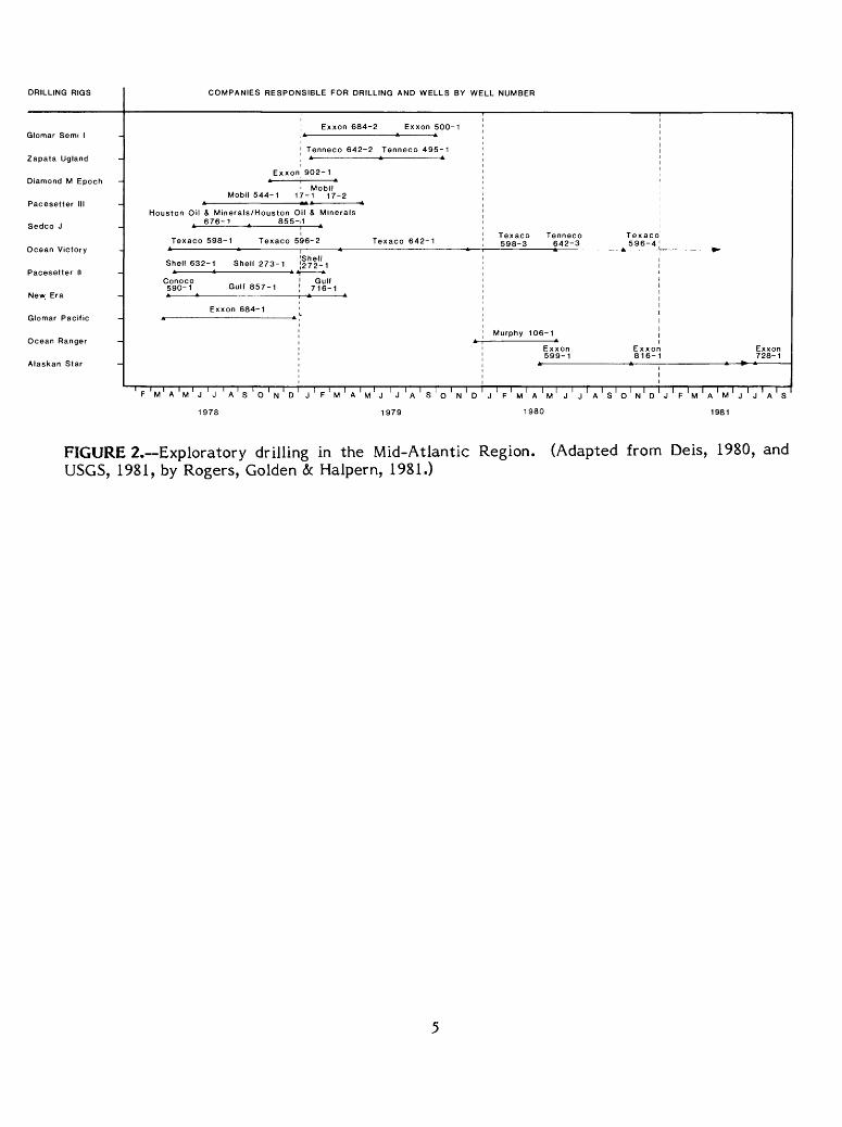
2. Chart of exploratory drilling in the Mid-Atlantic Region. ....... 5
Table
TABLE 1. Mid-Atlantic Regional Technical Working Group Committee members ............
m

INTRODUCTION
In November 1979, the U.S. Geological Survey's Office of Outer Continental Shelf (OCS) Information issued the initial report, Outer Continental Shelf Oil and Gas Activities in the Mid-Atlantic and their Onshore Impacts: A Summary Report, November 1979. TheOffice of OCS Information has published two updates to the initial summary report. Updates are published approximately every 6 months in order to provide additional and revised information on events occurring after the initial summary report. A new regional summary report is published only if a series of significant Federal OCS oil and gas events occur. The purpose of this report was to provide State and local governments with current information about offshore oil- and gas-related activities in the areas extending from the northern tip of Long Island, New York, to Cape Hatteras, North Carolina (fig. 1). The summary report provided resource and reserve estimates, anticipated production, trans portation strategies, and information concerning onshore support activities and production facilities such as refining, storage, and material warehousing, to assist in planning efforts and the decisionmaking process.
Update 1 was published in June of 1980, and it covered events that had occurred since the initial summary report. Update 2 was published in February of 1981. This report is Update 3, August 1981, and it will discuss Outer Continental Shelf oil and gas activities and their onshore impacts for the Mid-Atlantic Region since January of 1981. This report is intended to supplement the initial Mid-Atlantic Summary Report and subsequent updates. The format of this update parallels that of the summary report. Copies of the Mid-Atlantic Summary Report (MacPherson and Bookman, 1979, USGS Open-File Report 80-626), Update 1 (Deis, 1980, USGS Open-File Report 80-17), and Update 2 (Dorrier, 1981, USGS Open-File Report 81-603) may be obtained from the Office of Outer Continental Shelf Information, Conservation Division, U.S. Geological Survey, National Center, Reston, Virginia 22092, (703) 860-7166.
Atlantic Index
In addition to the regional summary reports, indexes of information have been prepared by the U.S. Geological Survey (USGS) in conjunction with the Bureau of Land Management (BLM) to further supplement information being made available to State and local governments for planning and decisionmaking purposes. An Atlantic Index has been released (Salzmann, 1981, USGS Open-File Report 80-1201). The index provides detailed information on the oil and gas lease-sale process, the leasing schedule and sale history, ongoing programs, studies conducted about the area, and State and local involvement in the OCS leasing program.
Leasing Schedule
Pursuant to section 18 of the OCS Lands Act Amendments of 1978, the Secretary of the Interior shall annually review and revise the OCS oil and gas leasing program. Revisions to the program are currently under way to streamline lease sale procedures, to offer areas of high potential earlier, and to offer more acreage for leasing.

CONNECTICUT
PENNSYLVANIA
Lindenkohl Canyon
WMmington Canyon
-^--Continental Shelf
THE MID-ATLANTIC REGION
U.S. Department of the InteriorGeological Survey
Mid-Atlantic Summary Report
Tracts tentatively selected for Lease Sale 59 (December 1981)
Tracts leased as a result of Lease Sale 40 (August 1976) and 49 (March 1979)
FIGURE 1.—The Mid-Atlantic Region OCS, Lease Sales 40 and 49 tracts, and Lease Sale 59 tract selection. (Adapted from Dorrier, 1981, by Rogers, Golden <5c Halpern, 1981.)
A proposed 5-year leasing schedule was published in July 1981, and a final schedule is expected to be approved late this year or early in 1982. Until the final schedule is approved, all sale dates noted in this report are based on the June 1980 final schedule. However, pre- lease-sale steps for sales under way may be changed to reflect streamlining efforts and may not match those shown in this report.
OFFSHORE OIL AND GAS RESOURCES OF THE MID-ATLANTIC REGION
Geologic Aspects of the Mid-Atlantic Region
A description of the petroleum geology of the Mid-Atlantic Region was provided in the Mid-Atlantic Summary Report (Macpherson and Bookman, 1980; USGS Open-File Report 80- 17). Also, a discussion of the geologic aspects of the Lease Sale 59 area is included in Update 2, February 1981 (Dorrier, 1981, USGS Open-File Report 81-603).
Resource and Reserve Estimates
No changes have occurred in the mean resource and reserve estimates since the publication of the February 1981 Update.
For proposed OCS Lease Sale 59, estimates of undiscovered recoverable oil and gas resources have also been made (BLM, 1981). These estimates help in evaluating the hydrocarbon potential of a sale area prior to leasing. Recent risked mean estimates made by the U.S. Geological Survey predict that up to 577 million barrels (91.7 million m3) of oil and 4.56 trillion cubic feet (0.13 trillion m3) of natural gas may be located in the Lease Sale 59 area (BLM, 1981). The USGS conditional mean estimates for Lease ,Sale 59 are 962 million barrels (152.9 million m3) of oil and 7.6 trillion cubic feet (0.21 trillion m3) of natural gas. An explanation of the procedures for making these estimates were reviewed in Update 2, February 1981 (Dorrier, 1981, USGS Open-File Report 81-603).
MAGNITUDE AND TIMING OF OFFSHORE DEVELOPMENT
Offshore Exploration
The first exploratory drilling in the Mid-Atlantic Region began in March of 1978. A detailed history of the offshore exploration can be found in the initial summary report and subsequent updates.
Lease Sale 40 was the first sale on the Atlantic OCS and was held on August 17, 1976. The sale drew $1.1 billion in total bids for 93 tracts leased in the Baltimore Canyon Trough. The second lease sale for the Mid-Atlantic was Lease Sale 49. The sale was conducted on February 28, 1979, and drew $41.7 million on 39 tracts leased also located in the Baltimore Canyon area. Of the 132 leases acquired in these two sales, 124 are still active as of June 15; 8 tracts have been relinquished.
At the time the previous update to the Mid-Atlantic Summary Report was published (February 1981), two companies were drilling in the region. Exxon was drilling a wildcat on
Block 816 (fig. 2), with the semisubmersible rig Alaskan Star. The spud date of the Toms Canyon well was November of 1980, with a proposed target depth of 18,500 feet (5,639 m). During late April 1981, a total depth of 17,753 feet (5,411 m) was reached (U.S. Department of the Interior, 1981). Plugging operations were conducted, and the well was abandoned May 7, 1981. The rig was then moved to Block 728, 5 miles (8.0 km) north, to begin drilling May 9, 1981. This well was located in 432 feet (132 m) of water and was plugged and abandoned on July 4, 1981.
The second rig in the Mid-Atlantic is ODECO's semisubmersible Ocean Victory, operated by Texaco. This rig was located south of the Hudson Canyon and is drilling the fourth well in Block 598. The well was spudded in October of 1980, with an intended total drilling depth of 16,500 feet (5,029 m). During February, well testing operations were conducted, and the well was plugged and abandoned in late March after being declared noncommercial. The Ocean Victory was sent to Davisville, Rhode Island, for overhaul before proceeding to the North Sea area. This failure at locating commercial volumes of oil or gas brings Baltimore Canyon's dry hole total to 21 since drilling began in March 1978 (Coastal Zone Management, 1981, p. 2).
Eight leases, held by Gulf Oil Corp., Conoco Inc., and Shell Oil Co., were relinquished on eight tracts in the Baltimore Canyon. The tracts were valued at $90.9 million when they were leased in 1976, and they are located 70 to 90 miles (113-115 km) east and southeast of Atlantic City, New Jersey (Crawford, 1981, p. 14). These leases would not have expired until April and May 1982. Groups led by Shell held six of the relinquished leases (Blocks 184, 228, 220, 232, 272, 273), and a Gulf-Conoco partnership held the other two. Two tract leases terminated by Gulf and Conoco (Blocks 718, 719) were a part of the once-promising Great Stone Dome structure. None of the leases acquired in Lease Sale 49, in February 1979, have been relinquished.
On April 2, 1981, Shell Oil had an exploratory plan approved for Block 145 (under Lease A-0145) for the Mid-Atlantic.
Lease Sale 59
Proposed Lease Sale 59, scheduled for December 1981, is the third offshore oil and gas sale in the Mid-Atlantic. The call area consisted of 3,513 blocks covering 20 million acres (8.1 million hectares) off the coasts of New York, New Jersey, Delaware, Maryland, Virginia, and North Carolina (fig. 1). Fourteen companies nominated 765 blocks covering 4.3 million acres (1.72 million hectares). In December 1979, 253 tracts, totaling 1.44 million acres (0.58 million hectares) were selected. The tracts are in water depths from 295 to 8,200 feet (90-2,500 m), ranging from 48 to 138 miles (15-42 km) offshore. Most of these blocks extend seaward from areas already leased in Sales 40 and 49 (Salzmann, 1981, USGS Open-File Report 80-1202). Almost all of the tracts lie beyond the shelf break, in deep water on the Continental Slope. Twenty-three of these deepwater tracts were among the 27 withdrawn from Lease Sale 49 because of concern over unstable bottom conditions.
Additional interest in Lease Sale 59 has been generated because of tracts having hydrocarbon-bearing potential in a possible buried carbonate reef-platform complex (Schlee and Grow, 1980, p. 148). The carbonate complex, largely of Jurassic age, seems to occur with gaps from off Mexico, north through the Gulf of Mexico, and along the Atlantic Continental Margin (Oil and Gas Journal, 1980, p. 72). The thickest of the complex is not well established but may be as much as 20,000 feet (6,096 m) thick and about 15 miles (24 km) wide, and it is possibly bordered by thick layers of promising source rocks (U.S. Department of the Interior, 1980b, p. 2).
DRILLING RIGS
Glomar Semi 1
Zapata Ugland
Diamond M Epoch
Ocean Victory
Pacesetter II
New Era
Glomar Pacific
Ocean Ranger
COMPANIES RESPONSIBLE FOR DRILLING AND WELLS BY WELL NUMBER
Exxon
Mobil 544-1 1
Houston Oil & Minerals/Houston O A 676-1 4 855-
Texaco 598-1 Texaco 5
Shell 632-1 Shell 273-1
5°90-1 Gulf 857-1
Exxon 684-1
Exxon 684-2 Exxon 500-1
Tenneco 642-2 Tenneco 495-1
902-1
Mobil 7-1 17-2
I & Minerals 1 A
96-2 Texaco 642-1
Shell 272-1
Gulf 716-1
Texaco Tenneco Texaco 598-3 642-3 596-4
Murphy 106-1
Exxon Exxor 599-1 816-
Exxon 728-1
' F ' M ' A ' M ' , ' ! ' A ' 0 ' « ' K, ' n ' , 1 C ' ,. 1 A ' .. ' , 1 , ' . ! e 1 „ ' L. ' r, ' ,'.'., '.1 .J , ' ' . ' o ' ,J i. ' rj , 1 «-' ..'.'»' . ' , ' . ] r~
FIGURE 2.—Exploratory drilling in the Mid-Atlantic Region. (Adapted from Deis, 1980, and USGS, 1981, by Rogers, Golden <5c Halpern, 1981.)

ENVIRONMENTAL IMPACT STATEMENT. On May 22, 1981, the final environmental impact statement (EIS) for proposed Lease Sale 59 was released by BLM's Outer Continental Shelf Office, New York, New York (BLM, 1981).
The OCS oil and gas summary reports are meant to complement the EIS. The EIS included archeological, biological, geological, and military considerations, in order to protect sensitive areas. The EIS also includes an analysis of potential oil spills and the probability of their reaching the coastline.
COST WELL. The tight rig market has put some restraints on attempts to spud a third Continental Offshore Stratigraphic Test (COST) well in the Baltimore Canyon before time limits set by OCS Lease Sale 59 expire (Crawford, 1981b, p. 13). The Canyon B-4 test well was scheduled to spud early in December of 1980, but plans were cancelled due to unavailability of a rig. Information on the earlier COST wells can be found in the previous reports.
OIL AND GAS TRANSPORTATION STRATEGIES
When commercially producible quantities of oil and gas are located offshore, there must be a mechanism for their transport onshore for processing, refining, and distribution. The Department of the Interior's Bureau of Land Management has the lead role in the transportation planning process for oil and gas discovered on the OCS. This planning process is coordinated through BLM's Intergovernmental Planning Program for OCS Oil and Gas Leasing, Transportation, and Related Facilities (IPP). Each of BLM's six offshore leasing areas, including the South Atlantic Region, has an advisory committee called the Regional Technical Working Group (RTWG). Each working group meets approximately four times a year to offer advice to the BLM on technical aspects of leasing, transport of oil and gas to shore, and BLM's environmental studies program.
The Mid-Atlantic RTWG has had two meetings since the publication of the last update in February, 1981. A 2-day meeting was held January 13-14, 1981, in Philadelphia, Pennsylvania. During the meeting the committee discussed and made recommendations on the draft Hudson Canyon Transportation Management Plan. The plan is a report that is prepared for each leasing region. It discusses needs and constraints concerning the location of pipelines with respect to logical receiving sites onshore. Normally, transportation plans are developed by the RTWG, but because of time constraints, the regional BLM office prepared it in-house with the assistance of the RTWG. Also at this meeting, the RTWG discussed and commented on the draft environmental impact statement for Lease Sale 59. The committee also discussed and supplied input on the secretarial issue document for Lease Sale 59.
At a second meeting in Newark, New Jersey, on March 19, 1981, the committee offered suggestions concerning changes to the previously mentioned transportation plan. The plan was endorsed by the majority of the RTWG in May 1981, and it was released to the public in June 1981. A copy of the transportation plan is available from the BLM New York OCS Office, Jacob K. Javits Federal Building, Suite 32-120, 26 Federal Plaza, New York, NY 10278.
The current members of the Mid-Atlantic Regional Technical Working Group Commit tee are listed in table 1. Two new members have been added to the committee since the
r t 'jodate. Mr. Richard Hoffman, of the Federal Energy Regulatory Commission's Office ; 'J :r:; Ine and Producer Regulations, has joined the committee as an ad hoc member. Mr.
! ; r- imsley, the Mid-Atlantic Regional District Supervisor for the U.S. Geological

TABLE 1.—Mid-Atlantic Regional Technical Working Group Committee
Member Affiliation
Mr. Frank Basile Captain David Linde Dr. Peter Anderson Mr. Richard Hoffman Mr. Bert Brun Mr. Bruce Wamsley Dr. Robert Lippson Dr. Robert Jordan Mr. Kenneth Schwarz Dr. Norbert Psuty Mr. John Harmon Mr. James Smith Dr. Arthur Socolow Mr. Edward Wilson Mr. Carl Sullivan Mr. Derickson Bennett Dr. Richard Weaver Mr. Fletcher Hartley Ms. Germaine Gallagher Mr. David Keifer Mr. David Moore Dr. Joan Goldstein
Bureau of Land Management (Co-chairperson)U.S. Coast GuardEnvironmental Protection AgencyFederal Energy Regulatory CommissionFish and Wildlife ServiceU.S. Geological SurveyNational Oceanic and Atmospheric AdministrationState of DelawareState of MarylandState of New JerseyState of New YorkState of North CarolinaState of PennsylvaniaState of VirginiaAmerican Fisheries SocietyAmerican Littoral SocietyAmerican Petroleum InstituteInterstate Natural Gas Association of AmericaLeague of Women Voters of the United StatesMid-Atlantic Fisheries Management CouncilNew Jersey Conservation FoundationPrivate Citizen
For further information concerning the Mid-Atlantic Regional Technical Working Group Com mittee, contact Richard Barnett, Bureau of Land Management, Jacob K. Javits Building, Suite 32- 120, 26 Federal Plaza, New York, NY 10278 (telephone: (212) 264-1061).

Survey, has also joined the committee. The U.S. Geological Survey District Supervisors are now the representatives to all RTWG's.
In July 1981, all sale, study, administrative, and operational responsibilities, including those of the South Atlantic RTWG, were transferred from the BLM New Orleans OCS Office to the BLM New York OCS Office.
NATURE AND LOCATION OF NEARSHORE AND ONSHORE FACILITIES
Since the publication of the last update in February 1981, the level of activity concerning nearshore and onshore support facilities has remained fairly constant. This is due mostly to the low level of offshore oil- and gas-related activity in the region. Quonset Point and Davisville, Rhode Island, are the support centers for exploratory activity.
Brown and Root is selling acreage once planned as a site for a platform fabrication yard on a 2,000-acre (810-hectare) site in Cape Charles, Virginia (Ocean Construction Report, 1981, p. 1). The acreage is now priced at $10 million. Brown and Root bought the site in 1974 for $5 million in anticipation of building platforms to develop oil and gas resources off the Baltimore Canyon area.
CONCLUSION
At the present, there are no operators drilling in the Mid-Atlantic Region. The prime targets for future exploration will be in areas of 3,000 to 6,000 feet (914-1,829 m) depth of water, seaward of previously leased tracts. No commercial discoveries have been found during the 4-year drilling history of the area.
In conclusion, because of the minimal offshore oil- and gas-related activity in the Mid- Atlantic Region, the onshore impacts are also minimal. Little development has occurred as a result of exploration or development. The level of nearshore and onshore activity may increase with exploration associated with upcoming Lease Sale 59. More permanent onshore development will be contingent on the outcome of future exploration efforts. Several months after Lease Sale 59, the Office of OCS Information will publish a revision of the Mid-Atlantic Summary Report. After Lease Sale 59, the next sale is Lease Sale 76, which is tentatively scheduled for March 1983.
REFERENCES
Bureau of Land Management, 1981, Final Environmental Impact Statement: Proposed 1981 Outer Continental Shelf Oil and Gas Lease Sale Offshore the Mid-Atlantic States, OCS Sale No. 59, Outer Continental Shelf Office, New York, New York.
Coastal Zone Management, 1981, v. 12, no. 21, p. 2.
Crawford, Diane, 1981a, The world offshore: Offshore, v. 41, no. 3, p. 13-15.
——, 1981b, The world offshore: East Coast: Offshore, v. 41, no. 2, p. 13-15.
Deis, Jeffrey L., 1980, Update 1, June 30, 1980, Outer Continental Shelf oil and gas activities in the Mid-Atlantic and their onshore impacts: a summary report, November 1979: prepared for the Outer Continental Shelf Oil and Gas Information Program by Rogers, Golden & Halpern, U.S. Geological Survey Open-File Report 80-17.
Dolton, G.L., Carlson, K.H., Charpentier, R.R., Coury, A.B., and others, 1981, Estimates of undiscovered recoverable resources of conventionally producible oil and gas in the United States: a summary: U.S. Department of the Interior, U.S. Geological Survey, Open-File Report 81-192.
Dorrier, Richard T., 1981, Update 2, February 1981, Outer Continental Shelf oil and gas activities in the Mid-Atlantic and their onshore impacts: a summary report, November, 1979: prepared for the Outer Continental Shelf Oil and Gas Information Program by Rogers, Golden & Halpern, U.S. Geological Survey Open-File Report SI- 603.
Edwards, Stuart W., 1981, Reagan administration brings new approach to Federal OCS leasing: Oil and Gas Journal, v. 78, no. 18, p. 203-214.
Macpherson, George, and Bookman, Charles, 1980, Outer Continental Shelf oil and gas activities in the Mid-Atlantic and their onshore impacts: a summary report, November 1979: prepared for the Outer Continental Shelf Oil and Gas Information Program, by Rogers, Golden & Halpern, U.S. Geological Survey Open-File Report 80-17.
Ocean Construction Report, 1981, v. 7, no. 11, p. 1.
Oil and Gas Journal, 1980, USGS optimistic about Mid-Atlantic sale area, v. 78, no. 2, p. 72.
——, 1981a, U.S. Briefs, v. 79, no. 19, p. 90.
——, 1981b, U.S. Briefs, v. 79, no. 18, p. 112.
——, 1981c, Operators: no giveup on Baltimore Canyon, v. 79, no. 4, p. 119.
Salzmann, Martha A., 1981, Atlantic Index: January 1975-November 1980: prepared for the Outer Continental Shelf Oil and Gas Information Program by Rogers, Golden & Halpern, U.S. Geological Survey Open-File Report 80-1202.
Schlee, John S., and Grow, John A., 1980, Buried carbonate shelf edge beneath the Atlantic Continental Slope: Oil and Gas Journal, v. 78, no. 8, p. 148-159.

Tippee, Bob, 1981, Ham me H pushes for more industry action in deep water: Oil and Gas Journal, v. 79, no. 2, p. 113.
U.S. Department of the Interior, 1980a, Five-year OCS leasing schedule approved, news release, 3une 18, p. 5.
——, 1980b, Oil and gas prospects brighten for Mid-Atlantic OCS lease area, news release, May 16, p. 2.
——, 198la, Watt proposes new initiative to speed leasing in high potential offshore areas, news release, April 16, p. 4.
——, 19815, Weekly well status report: Atlantic Area OCS: Eastern Region, Washington, D.C., January 6 - 3une 4.
U.S. Geological Survey, 1981, Conservation Division, Atlantic area OCS well status reports, published weekly.
10
APPENDIX - OCS-RELATED STUDIES
Appendix D of the initial Mid-Atlantic Summary Report presented relevant Federal and State OCS-related studies. The following OCS-related studies were obtained by contacting appropriate agencies in the Mid-Atlantic States from North Carolina to New York. The studies listed below supplement the information provided in the initial Mid- Atlantic Summary Report or the first and second updates.
FEDERAL STUDIES
U.S. Department of the Interior:
Bureau of Land Management
The Bureau of Land Management of the U.S. Department of the Interior conducts an environmental studies program. The New York OCS Office of the Bureau of Land Management administers studies approved by the Washington Office for the Mid-Atlantic Region. Appendix C of the initial summary report described this program. Some of the studies were conducted by other agencies wihin the Department of the Interior as a part of the program. Completed studies may be reviewed at the New York OCS Office of the Bureau of Land Management, Jacob K. Javits Federal Building, 26 Federal Plaza, Suite 32- 120, New York, NY 10278, or at the Washington OCS Office of the Bureau of Land Management, 18th and C Streets, NW., Washington, DC 20240.
NOTE: There have been no significant changes in the status of the studies that were listed in the last update. The following booklet is available upon request from the Studies Staff of the New York OCS Office: "A Summary of Environmental Reports from the Environmental Studies Program and the New York OCS Office, March 1981." A summary,is provided for the reports that have been generated from BLM-funded studies in the North and Mid- Atlantic Regions, as well as brief descriptions of studies that are currently in progress.
STATE STUDIES
New Jersey
Rieser, Alison, and Spiller, Judith, 1981, Regulating drilling effluents on Georges Bank and the Mid-Atlantic Outer Continental Shelf: a scientific and legal analysis: submitted to the States of Maine, New Hampshire, Massachusetts, and New Jersey, 130 p. and tables. Limited distribution through the Maine State Planning Office, State House Station 38, 184 State Street, Augusta, ME 04333.
This study analyzes the issues surrounding the regulation of discharges from OCS oil and gas drilling operations with particular reference to the North and Mid-Atlantic Regions. Its objective was to assist the States in these regions in evaluating proposed drilling operations on Georges Bank and future drilling in the Mid-Atlantic. The report consists of a summary of the literature on the fate and effects of drilling mud discharges, a history of the permits that have been issued in four OCS Regions, and a discussion of issues concerning the monitoring of permit compliance. A separate section consisting of recommendations for National Pollutant Discharge Elimination
11

System permits in the North and Mid-Atlantic Regions will be released when the States funding the study have had an opportunity to consider and respond formally to the proposed permits.
Virginia
Armitage, Thomas M., and Hargis, William J., Jr., 1980, The Virginian Sea bibliography: Gloucester Point, Va., Virginia Institute of Marine Science Special Scientific Report no. 103, 600 p. Available from the Library, Virginia Institute of Marine Science, Gloucester Point, VA 23062.
This bibliography is a compendium of literature and environmental data concern ing the physical and chemical environment, biology, and fisheries of the Middle Atlantic Bight region. The geographical coverage extends from lat 41 degrees N. to lat 36 degrees N. and 200 miles (322 km) out from the coastal headlands. It was compiled in an effort to assess the present knowledge of the region. The bibliography is divided into three sections: a subject bibliography, a geographic index, and a section listing sources of unpublished data.
Rooney-Char, Ann Hayward, and Ayres, Ronald Page, 1978, Offshore pipeline corridors and landfalls in coastal Virginia: prepared for the Virginia Coastal Resources Management Program, Virginia Institute of Marine Science Special Report in Applied Marine Science and Ocean Engineering no. 190, 2 vols. Available from the Library, Virginia Institute of Marine Science, Gloucester Point, VA 23062.
This report is a planning effort aimed at anticipating and planning for the implications of oil and gas drilling on the Atlantic Continental Shelf. It is designed to provide technical information on pipeline siting and construction requirements as well as on the potential environmental impacts associated with pipelines. It is intended to assist State and local officials in making decisions about pipelines coming ashore in Virginia by identifying and discussing the range of potential problems and opportunities associated with pipeline activities.
12