The Macondo Well Blowout: Taking the Outer Continental Shelf Lands

National Commission on the Outer Limitof the Continental Shelf
Outer Limit of the Continental Shelf
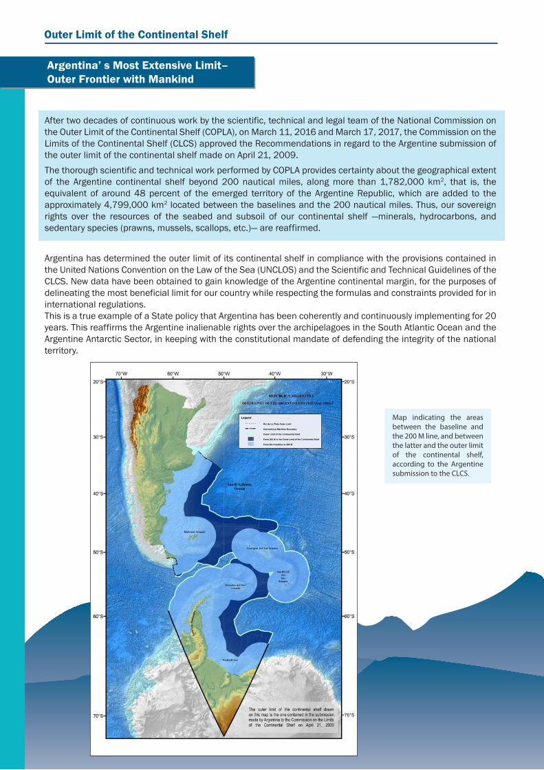
Argentina’ s Most Extensive Limit– Outer Frontier with Mankind
After two decades of continuous work by the scientific, technical and legal team of the National Commission on the Outer Limit of the Continental Shelf (COPLA), on March 11, 2016 and March 17, 2017, the Commission on the Limits of the Continental Shelf (CLCS) approved the Recommendations in regard to the Argentine submission of the outer limit of the continental shelf made on April 21, 2009.The thorough scientific and technical work performed by COPLA provides certainty about the geographical extent of the Argentine continental shelf beyond 200 nautical miles, along more than 1,782,000 km2, that is, the equivalent of around 48 percent of the emerged territory of the Argentine Republic, which are added to the approximately 4,799,000 km2 located between the baselines and the 200 nautical miles. Thus, our sovereign rights over the resources of the seabed and subsoil of our continental shelf ―minerals, hydrocarbons, and sedentary species (prawns, mussels, scallops, etc.)― are reaffirmed.
Argentina has determined the outer limit of its continental shelf in compliance with the provisions contained in the United Nations Convention on the Law of the Sea (UNCLOS) and the Scientific and Technical Guidelines of the CLCS. New data have been obtained to gain knowledge of the Argentine continental margin, for the purposes of delineating the most beneficial limit for our country while respecting the formulas and constraints provided for in international regulations.This is a true example of a State policy that Argentina has been coherently and continuously implementing for 20 years. This reaffirms the Argentine inalienable rights over the archipelagoes in the South Atlantic Ocean and the Argentine Antarctic Sector, in keeping with the constitutional mandate of defending the integrity of the national territory.
Map indicating the areas between the baseline and the 200 M line, and between the latter and the outer limit of the continental shelf, according to the Argentine submission to the CLCS.

As a coastal State, Argentina was one of the first countries to underscore the extent of its sovereign rights over the continental shelf. In 1916 —even before the Truman Proclamation—, Admiral Storni developed a doctrine claiming the rights over the continental shelf and all of the resources therein.
Some of the instruments used by our country to claim and ratify its rights over the continental shelf include Decrees No. 1386/44 and 14.708/46, as well as Law No. 17.094, which was enacted in 1966, in addition to the initiatives undertaken at the international level.
During the negotiations at the third United Nations Conference on the Law of the Sea, which began in 1973, Argentina became one of the members of the “marginalist” States’ group, and supported the proposal submitted to the Special Committee on the Peaceful Uses of the Seabed and the Ocean Floor beyond the Limits of National Jurisdiction, which
advocated the extension of the continental shelf to the outer edge of the continental margin.
In 1991 —before the entry into force of the United Nations Convention on the Law of the Sea (UNCLOS)—, Argentina enacted Law No. 23.968 on maritime areas. Article 6 of this law established the outer limit of the Argentine continental shelf up to the outer edge of the continental margin or up to 200 nautical miles (M) when the outer edge did not extend up to that distance. Argentina has therefore established the outer limit of its continental shelf in compliance with UNCLOS, which entered into force for Argentina on December 31, 1995. The submission to the CLCS sets out the fixed points establishing this limit.
The continental shelf comprises the seabed and subsoil of the submarine areas that extend beyond the territorial sea and throughout the natural prolongation of the land territory.
Legally, the continental shelf starts where the seabed and subsoil of the territorial sea end. In the case of Argentina, the territorial sea extends up to 12 nautical miles from the baselines.
Beyond that point, it is acknowledged that every coastal State has a continental shelf up to 200 nautical miles from the baselines.
However, when the natural prolongation of the land territory extends beyond such distance, the States are entitled to determine the outer limit of their
continental shelves on what is technically referred to as the “outer edge of the continental margin.”
In this maritime area, coastal States exercise sovereign rights for the purposes of exploring and exploiting their natural resources. These rights are exclusive in the sense that, should a coastal State not explore the continental shelf or not exploit the natural resources therein, nobody may conduct these activities without the express consent of such State. In addition, the rights of a coastal State over the continental shelf do not depend on its effective or notional occupation, or on any express proclamation.
A Bit of History
What is the Continental Shelf and How Far Does it Extend?

Outer Limit of the Continental Shelf
Distance formula: States shall choose the fixed points located not more than 60 nautical miles from the foot of the continental slope.
States may even combine both formulas and choose the more convenient one for each sector.
However, the application of these formulas must be in keeping with one of the two constraints set forth by UNCLOS: the limit may not be established beyond 350 nautical miles from the baselines, or 100 nautical miles from the 2,500 m isobath, which is a line joining 2,500 m depths. In this case, States can also combine the constraints and choose the more convenient one.
In order to determine the extension of the natural prolongation of the land territory ―which coincides with the outer limit of the continental shelf―, the outer edge of the continental margin needs to be established.
To do this, according to UNCLOS, the State shall first identify the location of the so-called “foot of the continental slope,” and then, it shall determine the outer limit points, using, to that end, any of the two formulas set forth in the Convention:
Sediment thickness formula: States shall choose the outermost fixed points from the foot of the slope, and shall measure the thickness of sedimentary rocks at that point. Then, they shall compare such measure with the shortest distance between the point chosen and the foot of the continental slope, so that the thickness of sedimentary rocks is, at least, 1 per cent of that distance.
¿How is the Outer Limitof the Continental Shelf Delineated?
Máx. 1:350 M from the baselinesMáx. 2:2,500 m isobath+ 100 M.
60 MSediments
Baseline
Oceanic Crust
Foot ofthe Slope
Distance Formula(Hedberg)
Sediment Thicness Formula(Gardiner)
1 per cent of the distancefrom the foot of the slope
Continental Crust
FORMULAE TO DETERMINE THE OUTER EDGE OF THE CONTINENTAL MARGIN - ARTICLE 76, PARAGRAPH 4
Mantle
100 M
0 200 350
Sediments
Baseline
Oceanic Crust
2,500 m isobath Max
imum
1
Continental Crust
CONSTRAINTS OF THE OUTER LIMIT OF THE CONTINENTAL SHELF - ARTICLE 76, PARAGRAPH 5
Max
imum
2
Mantle
Formula:Line where the sediment thickness is, at least, 1 per cent of the distance from the foot of the slope.Formula:60 M line from the foot of the slope.

UNCLOS created the Commission on the Limits of the Continental Shelf (CLCS), which is in charge of examining the information and data submitted by coastal States. It is a scientific and technical, non-political and non-legal body, made up of 21 experts in the fields of geology, geophysics or hydrography, elected by States Parties to UNCLOS to ensure equitable geographical representation. The members serve in their personal capacities, as they are not representatives of the States.
The coastal State which intends to establish, in accordance with Article 76, the outer limit of its continental shelf beyond 200 nautical miles shall submit to the Commission scientific and technical data supporting such delineation. The CLCS shall make recommendations to the coastal States on the conformity or non-conformity of the limit submitted with the rules established in UNCLOS.
According to its work schedule, the CLCS creates Subcommissions, consisting of 7 members, which consider the submissions made by the States and verify the conformity of the limit submitted with the relevant rules of UNCLOS. During the analysis process, the Subcommissions make questions, ask for clarifications, require different levels of information, or reprocess the data supporting the scientific grounds of the submissions. Once the analysis is over, the Subcommission issues recommendations, which are then approved or modified by the Commission in Plenary session.
Subsequently, the coastal State shall determine the outer limit of its continental shelf, which, if it is based on the CLCS recommendations, shall be considered final and binding for the international community.
In the case of disagreement with the recommendations of the Commission, the coastal State may, within a reasonable period of time, make a revised or new submission to the Commission.
Once UNCLOS came into force, Argentina started working to determine the outer limit of its continental shelf. To that end, the National Commission on the Outer Limit of the Continental Shelf (COPLA) was created in 1997 by means of Law No. 24.815.
COPLA is an inter-ministerial commission under the direct authority of the Ministry of Foreign Affairs and Worship, which presides over it, and it is made up of a member of the Naval Hydrographic Service and another one of the Ministry of Treasury and Public Finance. The members are assisted by a General Coordinator. The Commission has professionals from the various disciplines involved: geodesists, hydrographers, geologists, geophysicists, cartographers, oceanographers, Geographic Information System experts, lawyers, and international law experts. In addition, several state agencies and universities related to this field collaborate with COPLA.
Commission on the Limits of theContinental Shelf
State Body in Charge of Preparing the Submission

Outer Limit of the Continental Shelf
The Argentine continental margin, in addition to being one of the most extensive in the world, is, from a geological point of view, a complex margin which includes several types of margins classified in the Scientific and Technical Guidelines of the CLCS.When it started working, COPLA drafted a general task plan and work schedule which was developed within the deadlines set, according to the international rules in force.Oceanographic surveys were conducted on the Argentine continental margin, which made it possible to collect seismic, bathymetric, gravimetric and magnetic information. These data served as a basis to delineate the outer limit. The main surveys conducted up to 2009 include the following:
1996: FISIO-96 Survey1999: TESAC Survey2000: LITORAL ATLANTICO-III Survey2000: COPLA-2000 Survey2001: CAV PD-2001 Survey2002: COPLA 2001/2002 Survey2003: CAV PD-2003 Survey2004: COPLA BGR-2004 Survey2007: COPLA-2007 Survey2008: COPLA-2008 Survey2008: COPLA-HESPERIDES 2008 Survey2009: COPLA-2008/2009 Survey
After making the submission, other five surveys were conducted to obtain verification data:
2010: COPLA-2010A Survey2010: COPLA-2010B1 Survey2010: COPLA-2010B2 Survey2011: COPLA-2011 Survey2013: COPLA-2013 Survey2016: COPLA-2016 Survey
Quality controls, processing and filtering were performed on all the data obtained using different specialized software programs. Then, all the geophysical (seismic, magnetic, and gravimetric) and bathymetric lines were interpreted to delineate the limit. The foot of the continental slope points were determined on these lines, using the more convenient criterion (evidence to the contrary or maximum change in the gradient) in each area to ensure the greatest possible extension of the continental shelf.
Once those foot of the slope points were determined, either the 1 per cent sediment thickness formula or the 60 nautical miles from the foot of the slope formula was applied, depending on their convenience, and the constraint envelope was delineated. Finally, the 6,336 fixed points delineating the outer limit of the Argentine continental shelf were chosen.To illustrate the effort made, approximately 195,700 km of seismic, bathymetric, magnetic and gravimetric data were surveyed, equal to 4.89 times the equatorial circumference.It took a total of 950,000 man hours to perform the tasks until the Recommendations were obtained.
How Was the Outer Limit of the Argentine Continental ShelfDelineated?
Images from data collection surveys conducted on board Oceanographic Vessel ARA Puerto Deseado

On April 21, 2009, Argentina made a full submission to the CLCS of the outer limit of its continental shelf, including the natural prolongation of its territory pertaining to the continental and island sectors, and the Argentine Antarctic Sector. As stated in the “Executive Summary” of this submission, Argentine ratifies its legitimate and imprescriptible sovereignty over the Malvinas, Georgias del Sur and Sandwich del Sur Islands, and the corresponding island and maritime areas, as they are an integral part of the national territory, and expresses that the recovery of said territories and the full exercise of its sovereignty, while respecting the way of life of their inhabitants, and according to principles of International Law, constitute a permanent and unwaivable objective of the Argentine people, in agreement with the First Transitory Provision of the National Constitution. According to the Rules of Procedure of the CLCS, Annex 1, paragraph 5, “In cases where a land or maritime dispute exists, the Commission shall not consider and qualify a submission made by any of the States concerned in the dispute...” The CLCS has applied this provision to matters related to the Question of the Malvinas Islands, and, consequently, acknowledging the existence of a dispute, it has postponed the analysis of the limit in that area.
Similarly, the Commission has postponed the analysis of the continental shelf in the sector governed by the Antarctic Treaty.
The submission of the outer limit of the Argentine continental shelf made in April, 2009 consists of a Main Body, divided into six chapters, which are developed in 13 volumes and contain the scientific grounds for the outer limit of the Argentine continental shelf. Other 13 volumes and a large database compile supporting scientific and technical data. The most relevant bibliography was annexed in other 24 volumes. This extensive submission was presented in Spanish and also translated into English by our country, for the purposes of facilitating its assessment by the CLCS and avoiding any delays, as English is the Commission’s working language.
The Argentine Submission to the CLCS
The CLCS analyzes the submissions by way of Subcommissions composed of seven members, appointed according to their specializations and geographical representation, taking into account the specific elements of each submission.
After the submission was made on April 21, 20091, a delegation composed of COPLA members and officers from the Ministry of Foreign Affairs verbally explained to the CLCS plenary the most relevant points of the submission on August 26, 2009. This oral presentation was made in compliance with the provisions set forth in the Rules of Procedure of the CLCS. This allowed the Commission to broadly familiarize itself with the scientific data submitted by Argentina, for the purposes of determining the composition of the Subcommission that would initially analyze whether the Argentine submission was in keeping with the applicable international law rules. An audiovisual presentation was made, using a combination of specialized software programs and a geographic information system (GIS), which made it possible to unify the database with the relevant images and the cartography used for all the extent of our continental shelf.
1 The Executive Summary of the submission can be publicly accessed on the United Nations website:
http://www.un.org/Depts/los/clcs_new/submissions_files/submission_arg_25_2009.htm
Volume with the scientific grounds of the Argentine submission
Considerations of the Argentine Submission

In August 2012, the CLCS Subcommission responsible for considering the Argentine submission was created. During the stage of consideration of the Argentine submission, nine rounds of working sessions were held, between August 2012 and August 2015. In the last session held in August 2015, the Subcommission ended the analysis of the Argentine submission, and thus the stage of consideration by the CLCS Plenary started. On August 27 of that year, Argentina made its oral presentation to the Plenary, in keeping with the CLCS Rules of Procedure. On March 11, 2016, the CLCS adopted, by consensus, the Recommendations in regard with the Argentine submission.Given that the two northernmost points of the outer limit of the continental shelf ―close to the boundary with Uruguay, referred to as RA-01 and RA-02― had not been included in the Recommendations approved by the CLCS, as no agreement had been reached with the Subcommission that considered the Argentine submission about the role played by the Salado Transfer in the distortion of the margin in that area, COPLA worked intensely between March and October 2016, obtaining new data and performing reprocessing tasks which made it possible, without compromising on the scientific grounds contained in the original submission, to use other foot of the slope points so as to determine the two pending outer limit points. These new points, RA-01 and RA-02, are located 4.10 km and 6.9 km, respectively, further seaward than those submitted in 2009.With these new data, on October 30, 2016, Argentina made a Partial Revised Submission to the CLCS2. On February 14, 2017 Argentina made the oral presentation of such submission to the CLCS Plenary in its 43rd Session. After this presentation, the CLCS decided to consider the Partial Revised Submission during this session, and on March 14, the final presentation was made to the CLCS plenary.In that same session, on March 17, 2017, the CLCS adopted the Recommendations with regard to those two points. Once again, Argentina obtained positive Recommendations from the Commission in connection with the two points that had remained pending in the northern part of the limit. Thus, the analysis of all the outer limit points of the Argentine continental shelf has finished, except for the areas subject to a sovereignty dispute with the United Kingdom, and the sector governed by the Antarctic Treaty. By not pronouncing itself on the area surrounding the Malvinas, Georgias del Sur and Sandwich del Sur islands, the Commission acknowledged the existence of a sovereignty dispute between Argentina and the United Kingdom.All the studies conducted, in addition to making it possible to delineate the limit of our continental shelf in the most beneficial way for Argentina, have resulted in deeper knowledge of the marine geology and the existing resources. The delineation of the outer limit of the continental shelf is a true example of a State policy implying intensive work performed with clear objectives, professionalism and seriousness for almost 20 years, with the aim of strengthening our presence, preserving our resources, and reaffirming our sovereign rights in an area of such political, economic and strategic relevance as the South Atlantic.
2 The Executive Summary of the revised submission can be publicly accessed on the United Nations website:
http://www.un.org/depts/los/clcs_new/submissions_files/arg25_rev/ARG_PR_Resumen_Ejecutivo_SP.pdf
Esmeralda 1212 7th Floor – Office 717CP1007ABR, Autonomous City of Buenos AiresE-mail address: [email protected]: 4819-7611; Fax: 4819-7612www.plataformaargentina.gob.ar
Consideration of the Argentine Submission (Cont.)