Okanagan GPS Validation Network - British Columbia
26
Okanagan GPS Validation Network October 1997 Natural Resources Canada Geodetic Survey Division
Transcript of Okanagan GPS Validation Network - British Columbia
OkanaganGPS Validation Network
October 1997
Natural ResourcesCanada
Geodetic SurveyDivision

Okanagan GPS Validation Network
Prepared by
Geodetic Survey Division
Natural Resources Canada
in cooperation with
Geographic Data BC
Ministry of Environment, Lands and Parks
Additional copies of this
document are available from:
Geographic Data BC
Geo-Spatial Reference Unit
Fourth Floor, 1802 Douglas Street
Victoria, British Columbia
V0T 4K6
Tel: (250) 387-3164
Fax: (250) 356-7831

ii
Okanagan GPS Validation Network - October 1997
Foreword
The purpose of this booklet is to provide the basic information requiredfor users to test their GPS equipment and positioning methodology onthe Okanagan GPS Validation Network. Please contact GeographicData BC, Ministry of Environment, Lands and Parks, for informationrelated to this network that is not included in this document.

iii
Okanagan GPS Validation Network - October 1997
Table of Contents
Page1. Introduction to GPS Validation Networks .................................... 1
Background.......................................................................................................1Applications ......................................................................................................1Characteristics...................................................................................................3
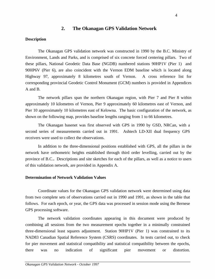
2. The Okanagan GPS Validation Network ...................................... 4
Description .......................................................................................................4Determination of Network Validation Values.....................................................4
Appendices
A. Station Descriptions and Site Sketches...........................................................7
Notice to Users .................................................................................................7GCM 436444 (NGDB 90HP1V) Pier 1 .............................................................8GCM 461467 (NGDB 90HP9V) Pier 9 .............................................................9GCM 584664 (NGDB 90HP7V) Pier 7 ...........................................................10GCM 625756 (NGDB 90HP10V) Pier 10 .......................................................11GCM 717892 (NGDB 90HP8V) Pier 8 ...........................................................12GCM 938951 (NGDB 90HP6V) Pier 6 ...........................................................13
B. Tables of Values.............................................................................................14
1. Ellipsoidal Coordinates ..............................................................................142. Geocentric Cartesian Coordinates ..............................................................153. UTM Mapping Plane Coordinates..............................................................154. Interstation Cartesian Coordinate Differences ............................................165. Absolute 95% 3-D Confidence Ellipsoids...................................................176. Absolute 95% Horizontal Confidence Ellipses............................................177. Absolute 95% Vertical Confidence Intervals ..............................................178. Relative 95% 3-D Confidence Ellipsoids ....................................................189. Relative 95% Horizontal Confidence Ellipses.............................................1910. Relative 95% Vertical Confidence Intervals ...............................................19
C. Contacts for Additional Information............................................................20
D. Pier Design - Okanagan GPS Validation Network ForcedCentering Pillars............................................................................................21
1. Cross Section ............................................................................................212. Forced Centering Plate ..............................................................................22

1
Okanagan GPS Validation Network - October 1997
1. Introduction to GPS Validation Networks
Background
The Global Positioning System (GPS) has dramatically reshaped surveying and navigation
in many parts of the world. The use of GPS positioning has become increasingly widespread.
The need for a “truth” against which to test GPS positioning accuracy and precision has led to the
establishment of GPS validation networks across Canada, also known as basenets, to serve as a
physical standard for evaluating GPS equipment, software and positioning methodologies.
The first GPS validation network was established in the Ottawa region in 1988. Since that
time other such networks have been established across the country, in collaboration with the
provincial agencies responsible for geodetic surveying within their jurisdictions. The map that
follows shows the locations of other GPS validation networks in Canada. Geodetic Survey
Division (GSD), Natural Resources Canada (NRCan) maintains sole responsibility of the Ottawa
network, including site maintenance and dissemination of basenet-related information such as
data. For other GPS validation networks, including the Okanagan basenet, this responsibility is
shared with the provincial survey agencies.
Geographic Data BC located, designed and installed the Okanagan and Greater
Vancouver networks in order to serve the needs of provincial users. GSD, NRCan established the
validation coordinates for the networks through precise GPS measurements. Each GPS validation
network was initially established using at least two separate measurement campaigns in different
years. Subsequent measurements may be performed periodically to check on pier movement.
Applications
GPS validation networks are mainly used to evaluate results obtained using a specific
combination of GPS equipment, software, and observation procedures. The full range of GPS
equipment, from hand-held C/A code receivers to geodetic quality dual frequency receivers, may
be checked. Similarly, the accuracies obtainable from different observation procedures such as
single point positioning, differential code, kinematic or static positioning techniques may be
assessed.

2
Okanagan GPS Validation Network - October 1997

3
Okanagan GPS Validation Network - October 1997
The validation networks may also be used to evaluate proposals from GPS survey
contractors. A "validation survey" on a GPS basenet may be required to assess the proposed GPS
positioning system, and determine with confidence whether it can meet contract accuracy
requirements. A positioning system in this context includes the equipment and procedures used
for data collection as well as the software and procedures used for the data processing and
adjustment.
Characteristics
A GPS validation network is typically comprised of between 5 and 10 forced centering
pillars or piers. Usually two of these pillars are also part of an Electronic Distance Measurement
(EDM) calibration baseline and form the core of the network. The network design provides GPS
baselines of varying lengths, usually ranging between 1 and 100 kilometres, and the design and
location of pillars is such that:
• forced centering is used to eliminate centering error ;
• sites are easily accessible;
• sites are generally clear of obstructions above 10 degrees from the horizon; and
• for stability and longevity, pillar monumentation is carried out using the same
specifications as for EDM calibration baseline pillars. (See Appendix D.)
The following section contains a description and map of the Okanagan GPS validation network,
and a brief explanation of the determination of coordinates listed in this document.
4
Okanagan GPS Validation Network - October 1997
2. The Okanagan GPS Validation Network
Description
The Okanagan GPS validation network was constructed in 1990 by the B.C. Ministry of
Environment, Lands and Parks, and is comprised of six concrete forced centering pillars. Two of
these pillars, National Geodetic Data Base (NGDB) numbered stations 90HP1V (Pier 1) and
90HP6V (Pier 6), are also coincident with the Vernon EDM baseline which is located along
Highway 97, approximately 8 kilometres south of Vernon. A cross reference list for
corresponding provincial Geodetic Control Monument (GCM) numbers is provided in Appendices
A and B.
The network pillars span the northern Okanagan region, with Pier 7 and Pier 8 within
approximately 10 kilometres of Vernon, Pier 9 approximately 60 kilometres east of Vernon, and
Pier 10 approximately 10 kilometres east of Kelowna. The basic configuration of the network, as
shown on the following map, provides baseline lengths ranging from 1 to 66 kilometres.
The Okanagan basenet was first observed with GPS in 1990 by GSD, NRCan, with a
second series of measurements carried out in 1991. Ashtech LD-XII dual frequency GPS
receivers were used to collect the observations.
In addition to the three-dimensional positions established with GPS, all the pillars in the
network have orthometric heights established through third order levelling, carried out by the
province of B.C.. Descriptions and site sketches for each of the pillars, as well as a notice to users
of this validation network, are provided in Appendix A.
Determination of Network Validation Values
Coordinate values for the Okanagan GPS validation network were determined using data
from two complete sets of observations carried out in 1990 and 1991, as shown in the table that
follows. For each epoch, or year, the GPS data was processed in session mode using the Bernese
GPS processing software.
The network validation coordinates appearing in this document were produced by
combining all sessions from the two measurement epochs together in a minimally constrained
three-dimensional least squares adjustment. Station 90HP1V (Pier 1) was constrained to its
NAD83 Canadian Spatial Reference System (CSRS) coordinates. In tests carried out, to check
for pier movement and statistical compatibility and statistical compatibility between the epochs,
there was no indication of significant pier movement or distortion.

Cherryville
Lumby
Hilton
Vernon
Kelowna
OkanaganLanding
Armstrong
Coldstream
90HP9V
90HP8V
90HP7V
90HP10V
90HP1V90HP6V
6
6
97
97
33
97
97A
GPS Basenet Station
Municipality
The Okanagan GPS Validation Network
90HP1V 43644490HP6V 93895190HP7V 58466490HP8V 71789290HP9V 46146790HP10V 625756
Note: Points on this map have been identified by their NGDB* station number. Corresponding GCM** station numbers are provided below:
NGDB Number GCM Number
* NGDB: National Geodetic Data Base** GCM: Geodetic Control Marker
0 10 20 30 kilometres

6
Okanagan GPS Validation Network - October 1997
Measurement History - Okanagan GPS Validation Network
Year ReceiverType
Number ofReceivers
SessionLength(hours)
Number ofSessions
GPS ProcessingSoftware
1990 AshtechLD-XII
6 4.5 8 Bernese v3.2
1991 AshtechLD-XII
5 5 5 Bernese v3.3
All coordinate values and error estimates can be found in Appendix B. The ellipsoidal,
geocentric Cartesian, and mapping plane coordinates for network piers are given in Tables 1, 2
and 3, respectively. The Cartesian coordinate differences between each of the pillars can be found
in Table 4. Absolute 95% confidence regions are provided in Tables 5, 6, and 7, while relative
95% confidence regions are provided in Tables 8, 9, and 10. Note that corresponding covariance
data is available, as described in Appendix C.
Separate confidence regions are given for the three-dimensional (3-D), horizontal (2-D)
and vertical (1-D) coordinates. This is necessary because the expansion factors used to compute
the 95% confidence regions are different for each case. The 3-D confidence ellipsoids should be
used when validating 3-D results. Similarly, the horizontal confidence ellipses should be used
when validating only horizontal results. The vertical confidence intervals should be used when
validating only vertical results. Separate horizontal and vertical validation tests must not be used
together as a validation of 3-D results.
The coordinates given in this document are to be used for validation purposes only. If
needed, adopted NAD83 survey control values are available from the Geo-Spatial Reference Unit,
Geographic Data BC (see Appendix C).
The descriptions, sketches and coordinate values provided in this booklet are intended to
provide all the basic information needed to use the Okanagan GPS validation network as a
physical standard for testing and validating GPS positioning systems to suit specific applications.
Details on obtaining further information, data or documents are given in Appendix C.

7
Okanagan GPS Validation Network - October 1997
Appendix A
Station Descriptions and Site Sketches
GCM Number NGDB Number Station Name
436444 90HP1V Pier 1
461467 90HP9V Pier 9
584664 90HP7V Pier 7
625756 90HP10V Pier 10
717892 90HP8V Pier 8
938951 90HP6V Pier 6
Notice to Users
• The Okanagan GPS validation network is located on public property. Any damage to private or public property which may occur during the use of the network is the responsibility of the user.
• Users must obey normal traffic safety laws.
• The network was installed with the cooperation of local residents and common courtesy should be observed during occupations.
• Some of the adjacent roads are not paved; please try to keep dust levels at a minimum by driving at a moderate rate of speed.
• Users may reserve the basenet, for validation purposes only, by contacting the agency specified on the station diagrams.
• Users are also asked to assist in the preservation of the network pillars. Please report any damage or potential dangers to:
Ministry of Environment, Lands and ParksGeographic Data BCGeo-Spatial Reference Unit4th Floor, 1802 Douglas StreetVictoria, British ColumbiaV8T 4K6Tel: (250) 387-3164Fax: (250) 356-7831
8
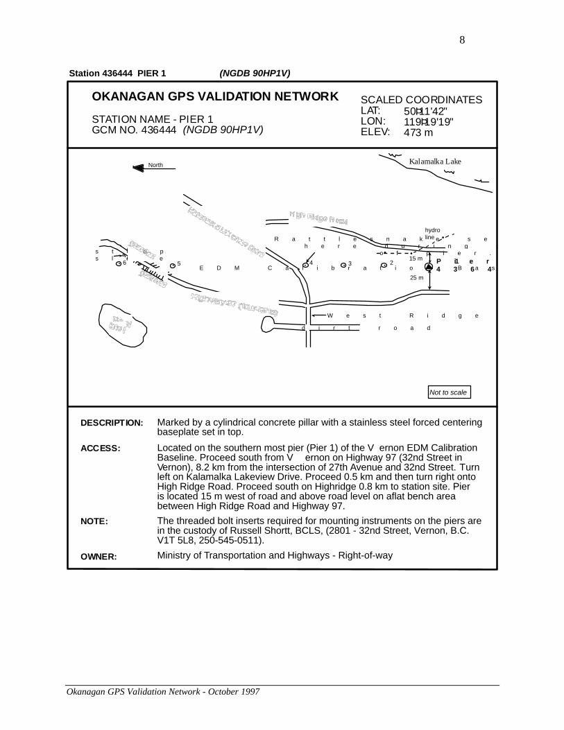
Okanagan GPS Validation Network - October 1997
OKANAGAN GPS VALIDATION NETWORK
STATION NAME - PIER 1GCM NO. 436444 (NGDB 90HP1V)
SCALED COORDINATESLAT:LON:ELEV:
50Þ11'42"119Þ19'19"473 m
DESCRIPTION: Marked by a cylindrical concrete pillar with a stainless steel forced centeringbaseplate set in top.
Located on the southern most pier (Pier 1) of the V ernon EDM CalibrationBaseline. Proceed south from V ernon on Highway 97 (32nd Street inVernon), 8.2 km from the intersection of 27th Avenue and 32nd Street. Turnleft on Kalamalka Lakeview Drive. Proceed 0.5 km and then turn right ontoHigh Ridge Road. Proceed south on Highridge 0.8 km to station site. Pieris located 15 m west of road and above road level on aflat bench areabetween High Ridge Road and Highway 97.
ACCESS:
Ministry of Transportation and Highways - Right-of-wayOWNER:
Not to scale
Kalamalka LakeNorth
• • • •
•
••
•
hydroline
25 m
15 m
R a t t l e s n a k e s e e n h e r e d u r i n g c o n s t r u c t i o n o f p i e r .
4 3 25 P i e r 14 3 6 4 4 4E D M C a l i b r a t i o n B a s e l i n e
W e s t R i d g e R o a d
s t e e ps l o p e
d i r t r o a d
6
Station 436444 PIER 1 (NGDB 90HP1V)
The threaded bolt inserts required for mounting instruments on the piers arein the custody of Russell Shortt, BCLS, (2801 - 32nd Street, Vernon, B.C.V1T 5L8, 250-545-0511).
NOTE:

9
Okanagan GPS Validation Network - October 1997
OKANAGAN GPS VALIDATION NETWORK
STATION NAME - PIER 9GCM NO. 461467 (NGDB 90HP9V)
SCALED COORDINATESLAT:LON:ELEV:
50Þ12'53"118Þ34'26"722 m
Not to scale
trees
trees
x x x x x x x x x x x x
rockoutcrop
Pier 9461467
50 m±road sign"First Aid2 km"
small pulloffarea - usecaution
cultivatedland
bldg
bldg
CHighway #6
to Vernon
400 m
Station 461467 PIER 9 (NGDB 90HP9V)
DESCRIPTION: Marked by a cylindrical concrete pillar with a stainless steel forced centeringbaseplate set in top.
Pier 9 is located roughly 60 km east of Vernon on Highway 6, approximately8.2 km east of junction of Highway 6 and road to Sugar Lake in Cherryville.Pier is on the northeast side of Highway 6 approximately 50 m from theroad and about 400 m southeast of Campbell Road.
ACCESS:
NOTE: The threaded bolt inserts required for mounting instruments on the piers arein the custody of Russell Shortt, BCLS, (2801 - 32nd Street, Vernon, B.C.,V1T 5L8, 250-545-0511).
Not knownOWNER:

10
Okanagan GPS Validation Network - October 1997
OKANAGAN GPS VALIDATION NETWORK
STATION NAME - PIER 7GCM NO. 584664 (NGDB 90HP7V)
SCALED COORDINATESLAT:LON:ELEV:
50Þ21'17"119Þ14'47"433 m
DESCRIPTION: Marked by a cylindrical concrete pillar with a stainless steel forcedcentering baseplate set in top.
Pier 7 is located north of Vernon on west side of Highway 97A, about1.6 km north of the intersection of Highways 97 and 97A. Pier issituated atop a rock outcrop 3 m above road level and is 1.0 m east offence line and 15 m west of highway centre line.
ACCESS:
Ministry of Transportation and Highways - Right-of-wayOWNER:
Not to scale
•
•
•
•
trees
parkinghere
bush
Station 584664 PIER 7 (NGDB 90HP7V)
The threaded bolt inserts required for mounting instruments on thepiers are in the custody of Russell Shortt, BCLS, (2801 - 32nd Street,Vernon, B.C., V1T 5L8, 250-545-0511).
NOTE:
PIER 7 584664

11
Okanagan GPS Validation Network - October 1997
OKANAGAN GPS VALIDATION NETWORK
STATION NAME - PIER 10GCM NO. 625756 (NGDB 90HP10V)
SCALED COORDINATESLAT:LON:ELEV:
49Þ53'19"119Þ20'36"639 m
Not to scale
•
•
x x x x x x x x x x x x x x x x x x x x x x x x
•
knoll
knoll
small knoll
smallrock
small rockapprox.1 x 1 x 1/2 m
25 m
cattle guardpaved
dirt
powerpole
powerpole
powerpolecorral
gate made from 3 metal wagon wheels
steephills
Pier 106 2 5 7 5 6
Station 625756 PIER 10 (NGDB 90HP10V)
NOTE: The threaded bolt inserts required for mounting instruments on the piersare in the custody of Russell Shortt, BCLS, (2801 - 32nd Street, Vernon,B.C., V1T 5L8, 250-545-0511).
From the intersection of Highways 97 and 33 (approximately 8 km south ofentrance to Kelowna airport), proceed east on Highway 33 for 3.1 km toMuir Street. Turn north (left) on Muir and turn immediately right ontoMcKenzie Road. Follow McKenzie up the hill, keeping to the right on hair-pin turn at El Paso Road (0.6 km from Muir Street). Stay on McKenzie afurther 1.4 km to Swainson Road. Turn right on Swainson and go 1.9 km(many twists and turns) to junction with Treetop Road. Turn left leavingthe pavement and pass through a cattle guard. Continue 250 m keepingto the left, to the station site which is about 25 m to the west of the dirttrack.
ACCESS:
DESCRIPTION: Marked by a cylindrical concrete pillar with a stainless steel forced centeringbaseplate set in the top. The pil lar is only 15 cm high and thus prone toobstructions.
OWNER: Not known.

12
Okanagan GPS Validation Network - October 1997
OKANAGAN GPS VALIDATION NETWORK
STATION NAME - PIER 8GCM NO. 717892 (NGDB 90HP8V)
SCALED COORDINATESLAT:LON:ELEV:
50Þ13'42"119Þ12'3"493 m
DESCRIPTION: Marked by a cylindrical concrete pillar with a stainless steel forcedcentering baseplate set in the top.
From the junction of Highway 97A and Highway 6 in V ernon, proceedeast on Highway 6 for 6.2 km to Grey Road. Turn north onto Grey Roadand proceed approximately 85 m to Pier #8 located northwest of road,approximately 35 m from centre line and approximately 8 m aboveroad level, on high point of gravel/mud embankment on top of a smallrock outcrop.
ACCESS:
Ministry of Transportation and Highways - Right-of-wayOWNER:
Not to scale
house
telephone pole
hay shed
corn field35 m
drive toPier
bushes
Highway 6to Vernon
6.2 km to intersectionwith Highway 97A
Station 717892 PIER 8 (NGDB 90HP8V)
PIER 8717892
The threaded bolt inserts required for mounting instruments on thepiers are in the custody of Russell Shortt, BCLS, (2801 - 32nd Street,Vernon, B.C., V1T 5L8, 250-545-0511).
NOTE:

13
Okanagan GPS Validation Network - October 1997
OKANAGAN GPS VALIDATION NETWORK
STATION NAME - PIER 6GCM NO. 938951 (NGDB 90HP6V)
SCALED COORDINATESLAT:LON:ELEV:
50Þ12'15"119Þ18'52"516 m
DESCRIPTION: Marked by a cylindrical concrete pillar with a stainless steel forced centeringbaseplate set in top.
From the junction of Highway 97 (32nd Street) and Highway 6 in V ernon,follow Highway 97 south for 7.4 km. Station is on the west side of highwayabout 1.1 km south of intersection with Birnie Road. Pillar is visible fromthe highway, situated on top of a cut approximately 8 m above road.
ACCESS:
Ministry of Transportation and Highways - Right-of-wayOWNER:
Not to scale
Kalamalka LakeNorth
• • • • •
•
••
hydroline
25 m
15 m
R a t t l e s n a k e s e e n h e r e d u r i n g c o n s t r u c t i o n o f p i e r .
4 3 25
P i e r 69 3 8 9 5 1
E D M C a l i b r a t i o n B a s e l i n e
W e s t R i d g e R o a d
1
s t e e ps l o p e
d i r t r o a d
C A U T I O N : P a r k i n g p r o b l e m w i t h P i e r 6 – n a r r o w s h o u l d e r ; b u s y h i g h w a y ; l o c a t e d n e a r c u r v e a n d o n d o w n g r a d e .
Station 938951 PIER 6 (NGDB 90HP6V)
The threaded bolt inserts required for mounting instruments on the piersare in the custody of Russell Shortt, BCLS, (2801 - 32nd Street, Vernon,B.C. V1T 5L8, 250-545-0511).
NOTE:
14
Okanagan GPS Validation Network - October 1997
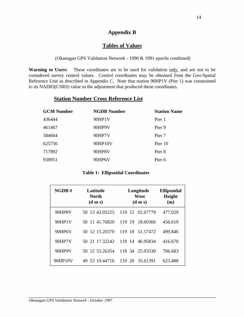
Appendix B
Tables of Values
(Okanagan GPS Validation Network - 1990 & 1991 epochs combined)
Warning to Users: These coordinates are to be used for validation only, and are not to beconsidered survey control values. Control coordinates may be obtained from the Geo-SpatialReference Unit as described in Appendix C. Note that station 90HP1V (Pier 1) was constrainedto its NAD83(CSRS) value in the adjustment that produced these coordinates.
Station Number Cross Reference List
GCM Number NGDB Number Station Name
436444 90HP1V Pier 1
461467 90HP9V Pier 9
584664 90HP7V Pier 7
625756 90HP10V Pier 10
717892 90HP8V Pier 8
938951 90HP6V Pier 6
Table 1: Ellipsoidal Coordinates
NGDB # LatitudeNorth(d m s)
LongitudeWest
(d m s)
EllipsoidalHeight
(m)
90HP8V 50 13 42.05225 119 12 02.67779 477.029
90HP1V 50 11 41.76820 119 19 18.60366 456.619
90HP6V 50 12 15.20370 119 18 51.57472 499.846
90HP7V 50 21 17.32242 119 14 46.95834 416.670
90HP9V 50 12 53.26354 118 34 25.93330 706.683
90HP10V 49 53 19.44716 119 20 35.61391 623.488

15
Okanagan GPS Validation Network - October 1997
Table 2: Geocentric Cartesian Coordinates
NGDB # X (m) Y (m) Z (m)
90HP8V -1994748.217 -3569072.876 4879443.299
90HP1V -2003678.992 -3567327.907 4877049.023
90HP6V -2002836.433 -3566922.448 4877743.580
90HP7V -1992283.737 -3558006.261 4888384.742
90HP9V -1956204.806 -3591829.938 4878655.187
90HP10V -2017857.505 -3589431.831 4855301.701
Table 3: UTM Mapping Plane Coordinates
NGDB # Northing (m) Easting (m) Zone
90HP8V 5566337.461 343034.396 11
90HP1V 5562885.047 334282.853 11
90HP6V 5563900.910 334850.734 11
90HP7V 5580494.155 340204.219 11
90HP9V 5563698.356 387711.194 11
90HP10V 5528892.789 331688.518 11
Warning to Users: Distances derived from UTM coordinates are distorted. They cannotbe compared to spatial distances derived from Cartesian or ellipsoidal coordinates withoutapplying the proper scale factors. UTM coordinates and distances should only be comparedto other UTM coordinates and distances. For more information, please contact GeodeticSurvey as described in Appendix C.

16
Okanagan GPS Validation Network - October 1997
Table 4: Interstation Cartesian Coordinate Differences
FromNGDB #
ToNGDB #
∆∆ X (m) ∆∆ Y (m) ∆∆ Z (m) Spatial Distance(m)
90HP8V 90HP1V -8930.775 1744.968 -2394.276 9409.36890HP8V 90HP6V -8088.216 2150.427 -1699.719 8540.06090HP8V 90HP7V 2464.480 11066.614 8941.443 14439.28790HP8V 90HP9V 38543.411 -22757.063 -788.112 44767.17090HP8V 90HP10V -23109.288 -20358.955 -24141.598 39132.378
90HP1V 90HP6V 842.558 405.459 694.558 1164.78090HP1V 90HP7V 11395.255 9321.646 11335.719 18580.72890HP1V 90HP9V 47474.185 -24502.031 1606.164 53448.36490HP1V 90HP10V -14178.513 -22103.924 -21747.322 34096.329
90HP6V 90HP7V 10552.696 8916.187 10641.161 17438.23790HP6V 90HP9V 46631.627 -24907.490 911.607 52874.59490HP6V 90HP10V -15021.071 -22509.383 -22441.879 35155.979
90HP7V 90HP9V 36078.931 -33823.677 -9729.554 50402.32790HP7V 90HP10V -25573.768 -31425.570 -33083.041 52307.472
90HP9V 90HP10V -61652.699 2398.107 -23353.486 65971.141

17
Okanagan GPS Validation Network - October 1997
Table 5: Absolute 95% 3-D Confidence Ellipsoids
NGDB # Major Semi-axis
MediumSemi-axis
MinorSemi-axis
length(m)
az.(deg)
inc.(deg)
length(m)
az.(deg)
inc.(deg)
length(m)
az.(deg)
inc.(deg)
90HP8V 0.04 34 87 0.02 2 -3 0.02 92 -2
90HP1V 0.05 31 87 0.02 4 -3 0.02 94 -1
90HP6V 0.05 31 87 0.02 5 -3 0.02 95 -1
90HP7V 0.05 32 87 0.02 5 -3 0.02 95 -1
90HP9V 0.05 24 87 0.02 5 -3 0.02 95 -1
90HP10V 0.05 28 86 0.02 4 -3 0.02 94 -1
Table 6: Absolute 95%Horizontal Confidence Ellipses
Table 7: Absolute 95%Vertical Confidence
Intervals
NGDB # MajorSemi-axis
MinorSemi-axis
NGDB # +/-
length(m)
az.(deg)
length(m)
az.(deg)
length(m)
90HP8V 0.02 3 0.01 93 90HP8V 0.03
90HP1V 0.02 5 0.02 95 90HP1V 0.03
90HP6V 0.02 5 0.02 95 90HP6V 0.03
90HP7V 0.02 6 0.02 96 90HP7V 0.03
90HP9V 0.02 5 0.02 95 90HP9V 0.03
90HP10V 0.02 5 0.02 95 90HP10V 0.03
Note: The semi-axes of the absolute confidence regions are shown to the nearest centimetre (rather than millimetre),because absolute accuracy with respect to the reference system NAD83(CSRS) is known only at the centimetre level.

18
Okanagan GPS Validation Network - October 1997
Table 8: Relative 95% 3-D Confidence Ellipsoids
FromNGDB #
ToNGDB #
Major Semi-axis
Medium Semi-axis
Minor Semi-axis
length(m)
az.(deg)
inc.(deg)
length(m)
az.(deg)
inc.(deg)
length(m)
az.(deg)
inc.(deg)
90HP8V 90HP1V 0.017 11 87 0.008 12 -3 0.005 102 090HP8V 90HP6V 0.019 17 87 0.009 12 -3 0.006 102 090HP8V 90HP7V 0.018 16 86 0.008 13 -4 0.005 103 090HP8V 90HP9V 0.018 9 86 0.008 12 -4 0.006 102 090HP8V 90HP10V 0.018 9 86 0.008 12 -4 0.005 102 0
90HP1V 90HP6V 0.018 20 88 0.008 9 -2 0.006 99 090HP1V 90HP7V 0.017 16 86 0.008 11 -4 0.005 101 090HP1V 90HP9V 0.016 15 86 0.008 7 -4 0.005 97 -190HP1V 90HP10V 0.016 12 87 0.008 7 -3 0.005 97 0
90HP6V 90HP7V 0.019 20 86 0.009 12 -3 0.006 102 090HP6V 90HP9V 0.019 16 86 0.008 9 -4 0.006 99 090HP6V 90HP10V 0.018 14 87 0.008 10 -3 0.006 100 0
90HP7V 90HP9V 0.017 16 86 0.008 10 -4 0.005 100 090HP7V 90HP10V 0.017 14 86 0.008 11 -4 0.005 101 0
90HP9V 90HP10V 0.016 13 85 0.008 7 -5 0.005 97 0

19
Okanagan GPS Validation Network - October 1997
Table 9: Relative 95%Horizontal Confidence Ellipses
Table 10: Relative 95%Vertical Confidence Intervals
FromNGDB #
ToNGDB #
MajorSemi-axis
MinorSemi-axis
FromNGDB #
ToNGDB #
+/-
length(m)
az.(deg)
length(m)
az.(deg)
length(m)
90HP8V 90HP1V 0.007 12 0.005 102 90HP8V 90HP1V 0.01290HP8V 90HP6V 0.008 12 0.005 102 90HP8V 90HP6V 0.01390HP8V 90HP7V 0.007 14 0.005 104 90HP8V 90HP7V 0.01290HP8V 90HP9V 0.007 12 0.005 102 90HP8V 90HP9V 0.01290HP8V 90HP10V 0.007 12 0.005 102 90HP8V 90HP10V 0.012
90HP1V 90HP6V 0.007 9 0.005 99 90HP1V 90HP6V 0.01390HP1V 90HP7V 0.007 11 0.005 101 90HP1V 90HP7V 0.01290HP1V 90HP9V 0.007 8 0.004 98 90HP1V 90HP9V 0.01290HP1V 90HP10V 0.007 8 0.004 98 90HP1V 90HP10V 0.011
90HP6V 90HP7V 0.008 12 0.005 102 90HP6V 90HP7V 0.01390HP6V 90HP9V 0.007 10 0.005 100 90HP6V 90HP9V 0.01390HP6V 90HP10V 0.007 10 0.005 100 90HP6V 90HP10V 0.013
90HP7V 90HP9V 0.007 10 0.005 100 90HP7V 90HP9V 0.01290HP7V 90HP10V 0.007 11 0.005 101 90HP7V 90HP10V 0.012
90HP9V 90HP10V 0.007 7 0.004 97 90HP9V 90HP10V 0.011

20
Okanagan GPS Validation Network - October 1997
Appendix C
Contacts for Additional Information
The following information is available in various formats and on different media, from the Geo-
Spatial Reference Unit (see below):
• Adopted NAD83 survey control values for network piers
• Official validation coordinates (in ellipsoidal, mapping plane or Cartesian format) as theyappear in this document
• Coordinates and associated covariance matrix for network piers
Ministry of Environment, Lands and ParksGeographic Data BCGeo-Spatial Reference Unit4th Floor, 1802 Douglas StreetVictoria, British ColumbiaV8T 4K6
Tel: (250) 387-3164Fax: (250) 356-7831WWW: http://www.env.gov.bc.ca/gdbc/
For more information on the Vernon EDM calibration baseline, please contact the above address.
For more information on the Okanagan GPS validation network analysis, and determination ofcoordinate values contained in this guide, contact:
Client Services SectionGeodetic Survey DivisionNatural Resources Canada615 Booth StreetOttawa, OntarioK1A 0E9
Tel. (613) 995-4410 or 992-2061Fax. (613) 995-3215Email: [email protected]
21
Okanagan GPS Validation Network - October 1997
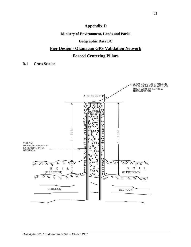
Appendix D
Ministry of Environment, Lands and Parks
Geographic Data BC
Pier Design - Okanagan GPS Validation Network
Forced Centering Pillars
D.1 Cross Section
BEDROCK BEDROCK
S O I L S O I L
2.54 CMREINFORCING RODSEXTENDING INTOBEDROCK
23 CM DIAMETER STAINLESSSTEEL OR BRASS PLATE 2 CMTHICK WITH 5/8 INCH N.C.THREADED PIN
(IF PRESENT)(IF PRESENT)
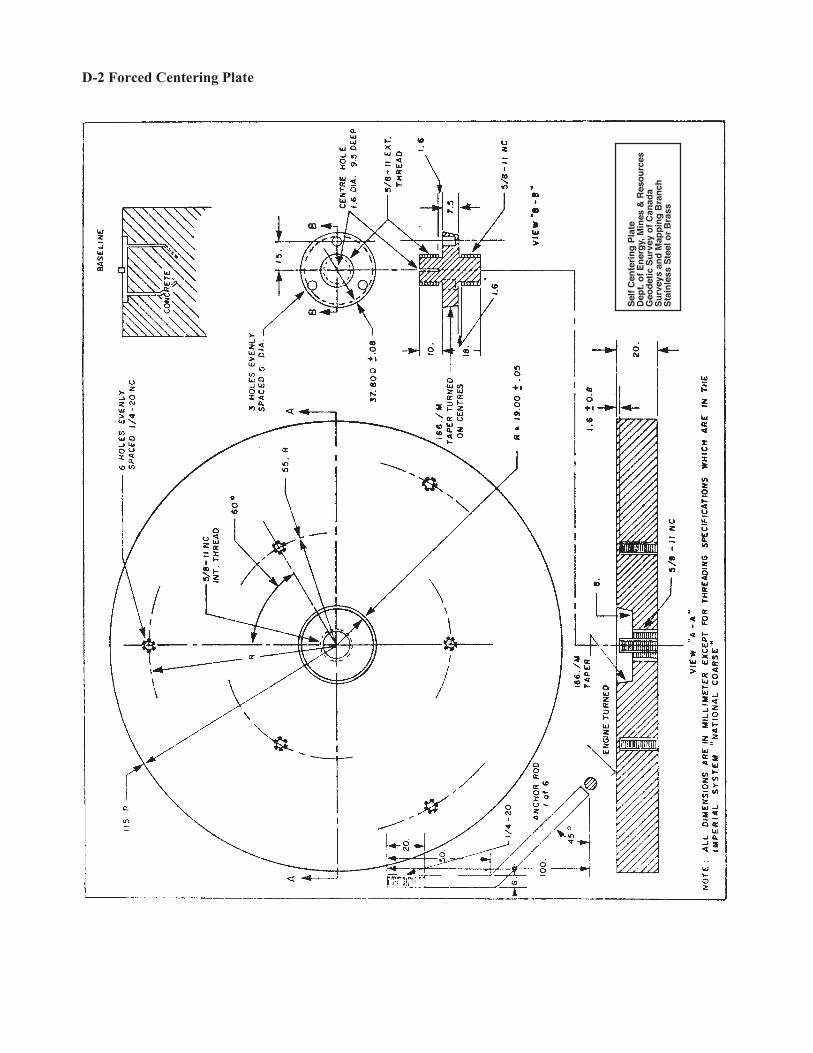
D-2 Forced Centering Plate
Sel
f C
ente
rin
g P
late
Dep
t. o
f E
ner
gy,
Min
es &
Res
ou
rces
Geo
det
ic S
urv
ey o
f C
anad
aS
urv
eys
and
Map
pin
g B
ran
chS
tain
less
Ste
el o
r B
rass