Oceanography is the scientific study of the ocean. - Matthew Maury is known as the father of...
26
-
Upload
justin-sanders -
Category
Documents
-
view
213 -
download
0
Transcript of Oceanography is the scientific study of the ocean. - Matthew Maury is known as the father of...


Oceanography is the scientific study of the ocean.
- Matthew Maury is known as the father of oceanography

Salinity
Density
Temperature
Currents
Waves
Effect on weather
Plants and animals

Pacific, Atlantic, Indian, Arctic, Antarctic
70% of the Earth is ocean

On land the average altitude is 3300 ft
- Mt. Everest is 29,028ft
Average depth of the ocean is 13,150 ft
- Mariana’s Trench 36,090 ft

Salinity is the measure of the dissolved solids in sea water.
Above average salinity occurs in areas of hot, dry climates. The area lies between 20* to 30* north and south of the equator.
Below average salinity where large amounts of fresh water enter oceans. Examples: areas of heavy rainfall, where glaciers enter the oceans and at the mouth of rivers.
Average Salinity is 35% (35 parts of dissolved salts per 1000 parts of sea water)
More Salt = More Dense

Salt is present in sea water in the form of dissolved ions.
Common salt (NaCl) makes up 31% of the salinity of salt water.
Many elements are found in sea water, including metals.
- Magnesium is mined from sea waterSalt is mined cheaply from sea water. Sunlight is the only energy needed to evaporate sea water.

The ocean is heated by solar radiation from the sun.
The Mixed Layer – the warm surface layer
Thermocline – layer of change in temp.
Deep Ocean Water - very cold


Most plant life in the ocean is located in the mixed layer.
- Sunlight penetration decreases rapidly with depth.
Phytoplankton are the most important group of plants
- tiny plants which float, moving wherever waves and currents carry them
- Basic food source for ocean life
Zooplankton are tiny floating animals that eat the phytoplankton
- They are then eaten by everything (including whales)

Two sources of Oxygen:
- Mixes into the ocean from the air above of the water
- Given off by plants that live in the water
Oxygen supply DECREASES with depth
Carbon Dioxide INCREASES with depth

Formed along mid-ocean ridges
Water is heated when it comes in contact with hot basalt
The hot water dissolves minerals and gasses from the basalt
Hydrogen sulfide is crucial to life near ocean-floor vents
Black Smoker

Precision Depth Recorder
- Uses sound signals
Sediment Samples
- obtained by core samples
Direct Observations
- undersea vehicles (robotic)
- Alvin mini-submarine (scientists)ALVIN

Continental Shelves are part of the continent that is underwater.
- Extend from the shoreline to the boundary between the shelf and the slope
- Nearly level surface
- Average depth to the end of the shelf is about 130 meters Continental Slopes begin at the edge of the shelf, where the depth starts to increase rapidly.
- Begins to slope toward the deep ocean
- Descends about 3 kilometers
- Occasionally slopes are cut into by submarine canyons (extension of river valleys)

Continental Rise is the gently sloping region between the continental slope and the ocean basin.
- Formed by the deposition of masses of sediment
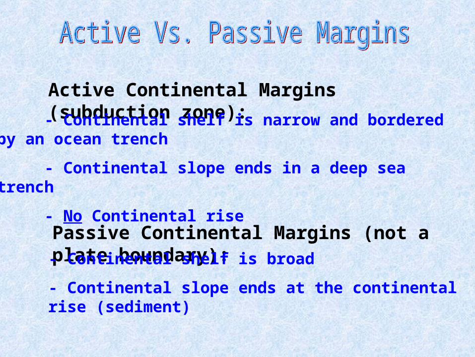
Active Continental Margins (subduction zone):
- Continental shelf is narrow and bordered by an ocean trench
- Continental slope ends in a deep sea trench
- No Continental rise
Passive Continental Margins (not a plate boundary):- Continental shelf is broad
- Continental slope ends at the continental rise (sediment)

Abyssal Plains
- Range in depth from 3000 to 6000 meters
- Flattest areas on the Earth’s surface
- Composed of sediments
Abyssal Hills- Small, rolling hills often occurring in groups next to continental
margins and oceanic ridge systems
- 1 to 10 kilometers across
- extend no higher than a few hundred meter above the
abyssal plain

Seamounts are cone-shaped mountain peaks that rise high above the ocean floor.
- Often near plate boundaries
- Most abundant in the Pacific
- represent volcanic activity (near plate boundaries or hot spots)
Guyots are flat-topped seamounts
- Their tops were originally above sea level
- The tops were removed by wave action
- Oceanic crusts sinks and the tops of guyots are below the
surface of the ocean
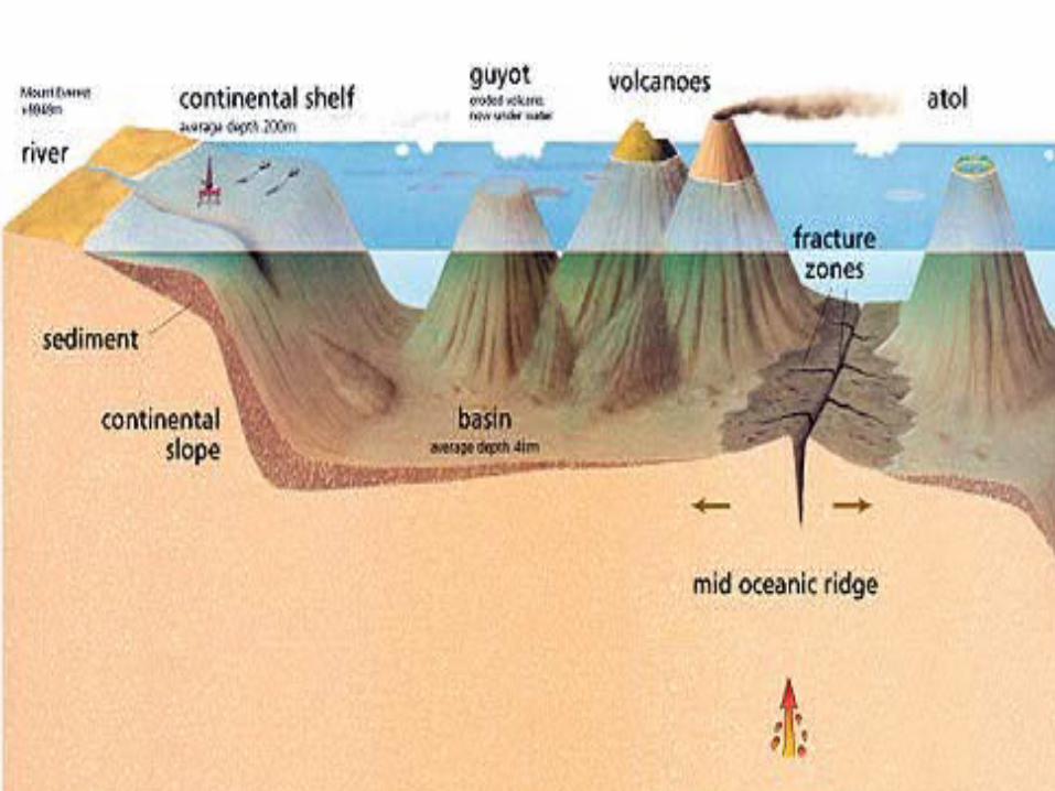
Atolls are ring shaped coral islands resulting from crustal sinking
- Coral reefs form around a volcanic island
- As the island sinks it leaves behind the circular reef with a
central lagoonDeep-sea trenches are long, narrow, steep sided troughs that parallel either continental margins or chains of volcanic islands.
- Most occur around the margin of the Pacific
- Depth of 2-4 kilometers below the ocean floor
- Peru-Chile trench is longest (5900 km along the west coast of
South America)
- Marianna’s trench is the deepest

Mid-Ocean Ridges are great undersea mountain ranges
- Diverging Plate Boundaries

Oozes are sediments made from microscopic shells
Muds and Clays are fine particles that have settle to the bottom of the ocean
Turbidites are deposits made by turbidity currents.
- Form graded beds
Authigenic sediments form directly on the seafloor.

Ocean currents can be defined as any continuous flow of water along a broad path in the ocean.
- Each water mass is identifiable because its temp., salinity, and chemical composition is distinct from water adjacent to it.
- Winds named for direction from which they blow
- Currents are named for the direction towards which they flow

- Current circles turn clockwise in the northern hemisphere and counter-clockwise in the southern hemisphere
- Currents flowing away from the equator carry warm water
- Currents flowing toward the equator carry cold water
Results:- The western sides of ocean basins have warm ocean currents moving away from the equator
- The eastern sides of ocean basins have cool ocean currents moving toward the equator

Density currents result when water in an area of the ocean has become more dense then the water around it.
- Evaporation affects density in warm, dry climates where salt in the water is left behind. (density increases)

- Cooling affects density in polar regions, causing the water to contract and take up less space. (density increases)
- Freezing affects density in polar regions, where sea water freezes leaving most of the salt behind. (density increases)Three great Polar region water masses:
- Antarctic Bottom Water
- North Atlantic Deep Water
- Antarctic Intermediate Water
Most Dense
Least Dense

Upwelling occurs when cold deep water, rich in nutrients comes to the surface.
- Most common on the western sides of continents
- Winds blowing parallel to the coastline and the effect of the Earth’s rotation, push surface water away from the coast
- Cold water rises to replace the surface water that has moved out