OCEAN COLOR 2019 - erepo.unud.ac.id
49
OCEAN COLOR 2019 The 7th Asian/16th Korea-Japan Workshop on Ocean Color (7th AWOC/16th KJWOC) December 11 - 14, 2019 Faculty of Science, Burapha University Chonburi,Thailand Programs and Abstracts
Transcript of OCEAN COLOR 2019 - erepo.unud.ac.id

OCEAN
COLOR
2019The 7th Asian/16th Korea-Japan
Workshop on Ocean Color
(7th AWOC/16th KJWOC)
December 11 - 14, 2019
Faculty of Science,
Burapha University
Chonburi,Thailand
Programs and Abstracts

The 7th Asian/16th Korea-Japan Workshop on Ocean Color
(7th AWOC/16th KJWOC)
11 – 14 December 2019
Room CL101 Central Laboratory Building
Faculty of Science, Burapha University, Thailand
Workshop Schedule
11 December 2019
Time Programs
8:30 – 9:30 Registration
9:30 – 10:00 Welcome remarks
10:00 – 10:30 Group photos and coffee break
10:30 – 11:30 Session 1 - Chair: Eko Siswanto, Co-chair: Siraporn Tong-u-dom
O-01-01 Multi-year analysis of GOCI products in comparison with MODIS and VIIRS Seonju Lee, Myung-Sook Park, Sunju Lee, Jae-Hyun Ahn
O-01-02 Initial validation of GCOM-C SGLI ocean products in Tokyo Bay Yuji Sakuno, Hiroto Higa, Hiroshi Kobyashi
O-01-03 Status of SGLI/GCOM-C and AHI/Himawari-8 Joji Ishizaka, Hiroshi Murakami, Kazunori Ogata, Mitsuhiro Toratani
11:30 – 13:00 Lunch
13:00 – 14:30 Session 2 - Chair: Young-Heon Jo, Co-chair: Mengmeng Yang O-02-01 A new algorithm to estimate chlorophyll-a concentrations in turbid Yellow Sea
water using a multispectral sensor in a low-altitude remote sensing system Ji-Yeon Baek, Young-Heon Jo, Wonkook Kim, Jong-Seok Lee
Dawoon Jung, Dae-Won Kim, Jungho Nam
O-02-02 Improvement of atmospheric correction scheme for SGLI ocean color data Mitsuhiro Toratani, Kota Katano, Masahiro Konno, Kazunori Ogata
O-02-03 Development of an atmospheric correction method by considering inherent
optical properties for a specified coastal area Taiga Nakayama, Hiroto Higa, Kazunori Ogata, Mitsuhiro Toratani, Salem Ibrahim Salem
O-02-04 Elucidating back-scattering properties in coastal areas and lakes by using
Hydroscat-6p and Radiative Transfer Simulation Hiroto Higa, Hidehito Taki, Salem Ibrahim Salem
14:30 – 15:00 Coffee break
15:00 – 16:30 Session 3 - Chair: Mitsuhiro Toratani, Co-chair: Jutarak Luang-on
O-03-01 Development of algorithm for detecting low-salinity plume in the East China
Sea during the summer using GOCI Young Baek Son, Joo-Hyung Ryu, Jong Kuk Choi, Kyeong-Hong Kim
O-03-02 Attempts to improve the simulation of phytoplankton absorption spectra for
various trophic statuses Salem Ibrahim Salem, Hiroto Higa, Joji Ishizaka and Kazuo Oki
O-03-03 Development of bio-optical model considering the variation in dominant
species of phytoplankton by hierarchical clustering Kanako Fujita, Hiroto Higa, Salem Ibrahim Salem
O-03-04 Characterization of absorption and attenuation coefficients and their
relationship with Chl-a in the southeastern Arabian Sea Kumaraswami Munnoor, Sisir Kumar Dash, Karri Ramu
Vinjamuri Ranga Rao and M. V. Ramana Murthy

The 7th AWOC 2019/16th KJWOC
2
16:30 – 17:30 Free time
17:30 – 22:00 Scientific networking and welcome party
12 December 2019
Time Programs
8:30 – 10:00 Session 4 - Chair: Young Baek Son, Co-chair: Tawatchai Na-u-dom
O-04-01 Tracing sea surface warming and cooling in the East China Sea during summer Gwang Seob Park, Yong Baek Son
O-04-02 Estimation of hourly sea surface salinity in the East China Sea using
Geostationary Ocean Color Imager measurements Dae-won Kim, Young-Je Park, Jin-Young Jeong, and Young-Heon Jo
O-04-03 Spatial variability of fishing grounds over oceanic front changes detected by
multiple satellite measurements in the East (Japan) Sea Young-Heon Jo, Dae-won Kim, Yejin Oh, Jae-Dong Hwang, Chu-Yong Chung
O-04-04 The decadal trend and seasonal patterns of the surface chlorophyll-a in 12
Large Marine Ecosystems in the North Pacific Sinjae Yoo, Christina Eunjin Kong
10:00 – 10:30 Coffee break
10:30 – 11:30 Session 5 - Chair: Genki Terauchi, Co-chair: Phattaranakorn Nakornsantiphap
O-05-01 Imprint of climate variability on Indo-Pacific ocean surface biology Eko Siswanto, Riza S. Yuliratno, Iskhaq Iskandar, Jonson L. Gaol
O-05-02 Variability of satellite chlorophyll-a over the spring neap tidal cycle in the
turbid Ariake Bay, Japan Mengmeng Yang, Joji Ishizaka, Joaquim I. Goes,
Tian Hongzhen, Elígio R. Maúre
O-05-03 Study of Internal solitary waves and chlorophyll-a distribution patterns in
Flores Sea, Indonesia using satellite data Chonnaniyah, I Wayan Gede Astawa Karang, Takahiro Osawa
11:30 – 13:00 Lunch
13:00 – 14:30 Poster presentations
14:30 – 15:00 Coffee break
15:00 – 16:30 Session 6 - Chair: Kumaraswami Munnoor, Co-chair: Dudsadee Leenawarat
O-06-01 Imprints of Indian Ocean Dipole on surface circulation and chlorophyll and
oxygen distributions of the Arabian Sea- A remote sensing perspective Benny N Peter, Meenakshi Sreejith, Eko Siswanto
O-06-02 The Distribution of chlorophyll-a concentration and fish catch during the
Indian Ocean Dipole 2019 in the Eastern Indian Ocean off Palabuhanratu Bay Jonson Lumban-Gaol, I Nyoman Metah Natih, Tri Hartanto
Berri Mirraz Rahman1, Arik Permana
O-06-03 Dynamic forcing for the chlorophyll blooms off Northern Borneo Che Sun
O-06-04 Seasonal and interannual variations of sea surface chlorophyll-a in the
Southern Makassar Strait revelaed by MODIS Riza Y. Setiawan, Anindya Wirasatriya, Iskhaq Iskandar
O-06-05 Assessment of phytoplankton abundance using remote sensing reflectance data
and Chlorophyll-a data derived using Aqua-Modis satellite to monitor massive
fish kills in the Jakarta Bay Sam Wouthuyzen, Tumpak Sidabutar, Eko Siswanto
The 7th AWOC 2019/16th KJWOC
3
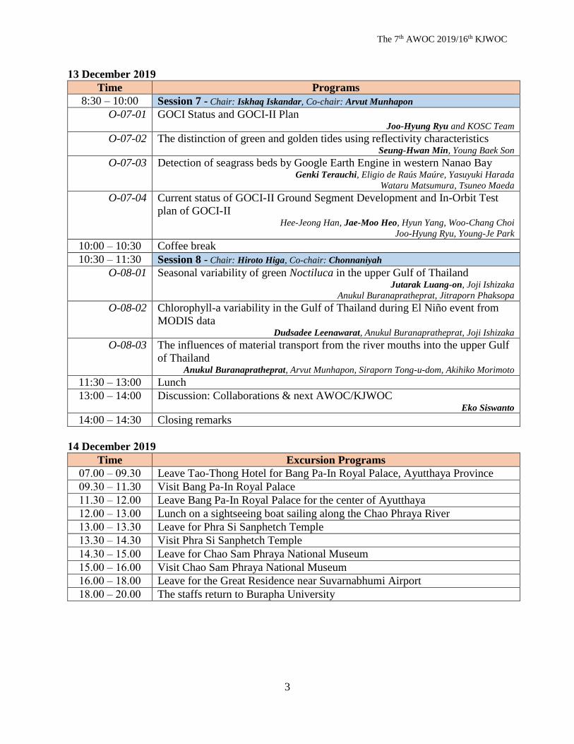
13 December 2019
Time Programs
8:30 – 10:00 Session 7 - Chair: Iskhaq Iskandar, Co-chair: Arvut Munhapon
O-07-01 GOCI Status and GOCI-II Plan Joo-Hyung Ryu and KOSC Team
O-07-02 The distinction of green and golden tides using reflectivity characteristics Seung-Hwan Min, Young Baek Son
O-07-03 Detection of seagrass beds by Google Earth Engine in western Nanao Bay Genki Terauchi, Eligio de Raús Maúre, Yasuyuki Harada
Wataru Matsumura, Tsuneo Maeda
O-07-04 Current status of GOCI-II Ground Segment Development and In-Orbit Test
plan of GOCI-II Hee-Jeong Han, Jae-Moo Heo, Hyun Yang, Woo-Chang Choi
Joo-Hyung Ryu, Young-Je Park
10:00 – 10:30 Coffee break
10:30 – 11:30 Session 8 - Chair: Hiroto Higa, Co-chair: Chonnaniyah
O-08-01 Seasonal variability of green Noctiluca in the upper Gulf of Thailand Jutarak Luang-on, Joji Ishizaka
Anukul Buranapratheprat, Jitraporn Phaksopa
O-08-02 Chlorophyll-a variability in the Gulf of Thailand during El Niño event from
MODIS data Dudsadee Leenawarat, Anukul Buranapratheprat, Joji Ishizaka
O-08-03 The influences of material transport from the river mouths into the upper Gulf
of Thailand Anukul Buranapratheprat, Arvut Munhapon, Siraporn Tong-u-dom, Akihiko Morimoto
11:30 – 13:00 Lunch 13:00 – 14:00 Discussion: Collaborations & next AWOC/KJWOC
Eko Siswanto 14:00 – 14:30 Closing remarks
14 December 2019
Time Excursion Programs
07.00 – 09.30 Leave Tao-Thong Hotel for Bang Pa-In Royal Palace, Ayutthaya Province
09.30 – 11.30 Visit Bang Pa-In Royal Palace
11.30 – 12.00 Leave Bang Pa-In Royal Palace for the center of Ayutthaya
12.00 – 13.00 Lunch on a sightseeing boat sailing along the Chao Phraya River
13.00 – 13.30 Leave for Phra Si Sanphetch Temple
13.30 – 14.30 Visit Phra Si Sanphetch Temple
14.30 – 15.00 Leave for Chao Sam Phraya National Museum
15.00 – 16.00 Visit Chao Sam Phraya National Museum
16.00 – 18.00 Leave for the Great Residence near Suvarnabhumi Airport
18.00 – 20.00 The staffs return to Burapha University

The 7th AWOC 2019/16th KJWOC
4
Poster session
No. Titles
P-01 Spatiotemporal variability of chlorophyll-a in the Andaman Sea (1998-2018) Christina Eunjin Kong
P-02 Effect of high atmospheric Nitrogen Dioxide (NO2) concentration on GOCI ocean color
products Donghee Kim, Myung-Sook Park, Jae-hyun Ahn
P-03 Physiological flexibility of phytoplankton impacts modeled chlorophyll and primary
production across the North Pacific Yoshikazu Sasai
P-04 Inherent and apparent optical properties in the Seto-Inland Sea in summer Eko Siswanto, Kazuyoshi Miyamura, Joji Ishizaka
P-05 Persistent Cloud Cover Curtails the Spring Phytoplankton Peak in the Toyama Bay Eligio Maure, Genki Terauchi
P-06 Analysis of ocean optical characteristics in the coastal waters of Yeosu in 2017 Eunkyung Lee, Jeongeon Moon, Tai-hyun Han, Youngje Park
P-07 Development of Level-2 Data Processing Software for GOCI-II Jae-Moo Heo, Hee-Jeong Han, Hyun Yang
P-08 Water Temperature Prediction and Gyroscope Signal Denoising using Deep Learning
Technology Min-Kyu Kim, Hyun Yang, Jong-Hwa Kim
P-09 Look Up Table Development of Simulated In-Situ Bio-optical Dataset for Satellite Data
Product Classification Nurul Inayah Bada Maulidya, Hiroto Higa, Salem Ibrahim Salem, Takayuki Suzuki
P-10 Effects of ancillary meteorological data on Rayleigh-corrected Top of the Atmosphere
reflectance using GOCI data Sinil Yang, Jae-Hyun Ahn, Myung-Suk Park, Young-Je Park
P-11 Thematic accuracy of seagrass coverage mapping using SPOT-7 and Sentinel-2A
imagery combined with in-situ data, a case study in Baho Seawater, Southeast Sulawesi,
Indonesia La Ode Muhammad Yasir Haya, Alit Zanuar, Amadhan Takwir, Masahiko Fujii

The 7th AWOC 2019/16th KJWOC
Oral Presentations

The 7th AWOC 2019/16th KJWOC
O-01-01
Multi-year analysis of GOCI products in comparison with MODIS and VIIRS
Seonju Lee1, 2, Myung-Sook Park2, Sunju Lee2, Jae-Hyun Ahn2 1 Ocean science, University of Science and Technology, Daejeon, South Korea
2 Korea Ocean Satellite Center, Korea Institute of Ocean Science & Technology, Busan, South Korea.
Corresponding e-mail: [email protected]
Chlorophyll, which is indicator for the amount of phytoplankton biomass, plays the
important role in marine ecosystem due to the conversion of carbon dioxide into oxygen
and organic matter through photosynthesis. Geostationary Ocean Color Imager (GOCI), the
world’s first geostationary ocean color satellite, has launched in June 2010 and has
provided the near real-time ocean color products over the East Asian Marginal Seas
(EASM). GOCI covered EASM region to include diverse ocean optical features (from clear
water over the northern Pacific to extremely turbid water over the Yellow Sea). Whereas the
GOCI data has been applied main to short-term monitoring, it is the time to examine multi-
year GOCI records to its consistency with the well-known NASA’s ocean color satellites
over the EAMS.
We compare the consistency of chlorophyll-a data among the GOCI, MODIS, and
VIIRS on the seasonal and inter-annual variations from 2011 to 2018. Although the spatial
patterns are quite similar for all three satellites, the GOCI tends to underestimate the
chlorophyll-a concentration compared to MODIS and VIIRS. Considering our regional
coefficients in OC3 algorithm may partly contribute to the underestimation in GOCI
chlorophyll-a but other factors (atmospheric correction) will be discussed in this study.

The 7th AWOC 2019/16th KJWOC
O-01-02
Initial validation of GCOM-C SGLI ocean products in Tokyo Bay
Yuji Sakuno1, Hiroto Higa2, Hiroshi Kobyashi3 1 Graduate School of Engineering, Hiroshima University, Japan
2 Faculty of Urban Innovation, Yokohama National University, Japan
3 Graduate School of Interdisciplinary Research, University of Yamanashi, Japan
Corresponding e-mail: [email protected]
In recent years, heavy rain disasters have frequently occurred in Japan, and there is a
need to monitor water quality changes with high resolution and high frequency in coastal
areas. On the other hand, SGLI (Second Generation Global Imager) of GCOM-C (Global
Change Observation Mission) launched in December 2017 officially began distributing
general data from the end of December 2018 after a one-year validation period. SGLI sensor
has the ability to measure coastal water temperature and water quality once every 2-3 days
with 250-m resolution. However, the product accuracy validation in the coastal area is
insufficient. Therefore, in this study, we will introduce the estimation accuracy verification
results of SGLI ocean products such as SST (Sea Surface Temperature), Chl-a (Chlorophyll-
a concentration), and TSM (Total Suspended Matter) immediately after distribution of
general data.
The SGLI data used for the validation are SST, Chl-a, and TSM data from January to
August 2019 in Tokyo Bay. These data were downloaded from JASMES (JAXA Satellite
Monitoring for Environmental Studies) SGLI near real-time website. The field data used for
the validation is the surface data at every hour on the hour observed by the Ministry of Land,
Infrastructure, Transport and Tourism. As a result, the accuracy of SST products with a bias
of 0.05 °C and a standard deviation of 0.98 °C (N = 167) was obtained when the
underestimation time of 3 °C or higher was excluded. The data acquisition rate was about
20% every month. The acquisition rates in February, June, and July were very low. Chla and
turbidity (TSM) data have low estimation accuracy, so it may be necessary to improve the
algorithm in Tokyo Bay.

The 7th AWOC 2019/16th KJWOC
O-01-03
Status of SGLI/GCOM-C and AHI/Himawari-8
Joji Ishizaka1, Hiroshi Murakami2, Kazunori Ogata2, Mitsuhiro Toratani3 1 Institute for Space-Earth Environmental Research (ISEE), Nagoya University, Japan
2 EORC/JAXA, Japan
3 Faculty of Engineering, Tokai University, Japan
Corresponding e-mail: [email protected]
Japan Aerospace Exploration Agency (JAXA) launched Second-generation Global
Imager (SGLI) as Global Change Observation Mission-Climate (GCOM-C) on December 23,
2017. This sensor can observe color of the earth together with temperature including ocean
with 250m resolution with 1150 km cross track scan width, generally 2-day observation with
4 days cycle, with local descending time of 10:30am. The wavelength includes 380, 412,
443, 490, 530, 566, 672, 763, and 867nm. With the high resolution data, many of fine coastal
events can be detected. After the 1-year verification phase which showed good performance
of both optical and geophysical parameters, the version 1 global data is now opened from the
download site G-Portal (https://gportal.jaxa.jp/gpr/). For limited area around Japan, near real
time data with slightly better performance for chlorophyll-a is also easily obtained from
JAXA Satellite Monitoring for Environmental Studies (JASMES) cite
(https://www.eorc.jaxa.jp/cgi-bin/jasmes/sgli_nrt/index.cgi?lang=en).
Japan Metrological Agency (JMA) is operating Geostational Meteorological Satellite
Himawari-8 with Advance Himawari Imager (AHI) from October 2014. AHI is the first color
sensor for the Himawari series with 1 km resolution 470, and 640, 860 nm and 500 m of 510
nm with 2.5 min time resolution as well as 2 km resolution near infrared and infrared channels.
Even this sensor was not design for ocean color with wider wavelength and lower S/N ratio,
JAXA is providing hourly, daily and monthly chlorophyll-a data from Himawari-8 covering
the full-disk area including southeastern Asia and Oceania area, with 1 km resolution around
Japan and 5 km other than Japan from July 2015 (https://www.eorc.jaxa.jp/ptree/index.html).
The data is limited quality for coastal area but fairly reasonable for open ocean.

The 7th AWOC 2019/16th KJWOC
O-02-01
A New Algorithm to Estimate Chlorophyll-A Concentrations in Turbid Yellow Sea Water Using a Multispectral Sensor in a Low-Altitude Remote Sensing System Ji-Yeon Baek 1 , Young-Heon Jo 1, Wonkook Kim 2 , Jong-Seok Lee 1 , Dawoon Jung 1 ,
Dae-Won Kim 1 and Jungho Nam 3
1 Department of Oceanography, Pusan National University, Busan 46241, Korea;
[email protected] (J.-Y.B.); [email protected] (J.-S.L.); [email protected] (D.J.);
[email protected] (D.-W.K.) 2 Department of Civil and Environmental Engineering, Pusan National University, Busan 46241,
Korea; [email protected] 3 Korea Maritime Institute, Busan 49111, Korea; [email protected]
Corresponding e-mail: [email protected]
In this study, a low-altitude remote sensing (LARS) observation system was employed to
observe a rapidly changing coastal environment-owed to the regular opening of the sluice
gate of the Saemangeum seawall-off the west coast of South Korea. The LARS system uses
an unmanned aerial vehicle (UAV), a multispectral camera, a global navigation satellite
system (GNSS), and an inertial measurement unit (IMU) module to acquire geometry
information. The UAV system can observe the coastal sea surface in two dimensions with
high temporal (1 s−1 ) and spatial (20 cm) resolutions, which can compensate for the coarse
spatial resolution of in-situ measurements and the low temporal resolution of satellite
observations. Sky radiance, sea surface radiance, and irradiance were obtained using a
multispectral camera attached to the LARS system, and the remote sensing reflectance (Rrs )
was accordingly calculated. In addition, the hyperspectral radiometer and in-situ chlorophyll-
a concentration (CHL) measurements were obtained from a research vessel to validate the R
rs observed using the multispectral camera. Multi-linear regression (MLR) was then applied
to derive the relationship between R rs of each wavelength observed using the multispectral
sensor on the UAV and the in-situ CHL. As a result of applying MLR, the correlation and
root mean square error (RMSE) between the remotely sensed and in-situ CHLs were 0.94
and ~0.8 µg L−1 , respectively;
these results show a higher correlation coefficient and lower RMSE than those of other,
previous studies. The newly derived algorithm for the CHL estimation enables us to survey
2D CHL images at high temporal and spatial resolutions in extremely turbid coastal oceans.
The 7th AWOC 2019/16th KJWOC
O-02-02
Improvement of atmospheric correction scheme for SGLI ocean color data
Mitsuhiro Toratani1, Kota Katano2, Masahiro Konno2, Kazunori Ogata3 1 Department of Optical and Imaging Science and Technology, School of Engineering, Tokai University,
Japan
2 Graduate School of Engineering, Tokai University, Japan
3 Earth Observation Research Center, Japan Aerospace Exploration Agency, Japan
Corresponding e-mail: [email protected]
The SGLI observation began in January 2018 and its Version1 dataset was released in
December 2018. Currently, we are improving the processing algorithm for creating Version
2 data set. In this presentation, we will describe improvements to the atmospheric
correction algorithm for SGLI ocean color toward the release of the Version2 data set. The main improvements are the aerosol reflectance estimation in high-suspended
matter concentration areas and the correction scheme for absorptive aerosol reflectance.
In high suspended matter concentration, the contribution of water at the near infrared
region cannot be ignored. When the atmospheric correction was processed using Water-
leaving reflectance at near infrared bands of AERONET-OC in Ariake Bay with relatively
high suspended matter concentration, the accuracy of estimating aerosol reflectance, and
hence the water-leaving reflectance at visible bands can be improved in consideration with
water-leaving reflectance at the near-infrared region. The effect of improvement of aerosol
reflectance scheme in turbid water is shown.
If absorptive aerosol exists, it is known to overestimate the aerosol reflectance on the
shorter visible bands. In this study, the effect of absorptive aerosol was evaluated using
radiative transfer simulation and the influence of absorptive aerosol generated by forest fire
is evaluated. The effect of the absorbent aerosol correction method is shown.

The 7th AWOC 2019/16th KJWOC
O-02-03
Development of an Atmospheric Correction Method by Considering Inherent Optical Properties for a Specified Coastal Area
Taiga Nakayama1, Hiroto Higa1, Kazunori Ogata2, Mitsuhiro Toratani3, Salem
Ibrahim Salem4
1 Yokohama National University, Japan
2 Japan Aerospace eXploration Agency, Japan
3 Tokai University, Japan
4Kyoto University of Advanced Science, Japan
Corresponding e-mail: [email protected]
GCOM-C/SGLI launched at the end of December 2017 by JAXA, has an excellent
spatiotemporal resolution such as one-time observation every two or three days and the
spatial resolution of 250m. Therefore, it is expected to monitor coastal areas where water
environment change is significantly large, and the areas are comparatively small. However,
the high accuracy of water quality estimation is exceedingly difficult because the light
environment in coastal water changes complexly. In the traditional ocean color atmospheric
correction algorithm, it is assumed that the water leaving reflectance in the near-infrared
region is 0 and reflectance due to air in the visible bands is calculated after estimating the
reflectance of atmospheric scattering. However, as in the coastal region, in the case of organic
matter and inorganic matter increasing significantly, the water leaving reflectance in the near-
infrared region increases and the assumption does not hold. Therefore, an aerosol reflectance
is overestimated, and an error occurs in the estimation of the water leaving reflectance in the
visible region band.
In order to resolve the problem, there is the iterative method of estimating aerosol
reflectance while estimating water leaving reflectance in the near-infrared band using an in-
water model, and it is widely used in almost ocean color sensors. However, typically, an in-
water model in the iterative method is adequate for open ocean such as the case1 water; hence,
an aerosol reflectance is still overestimated in a coastal area or other high turbidity water area
such as the case2 water using this method.
In this study, we modified an in-water model of the iterative atmospheric correction
algorithm which is adequate for case1 water to the in-water model considering SIOPs
(Specific inherent optical properties) of coastal water as a target of Tokyo Bay where organic
matter is dominant. Thereby, we constructed the atmospheric correction method which is the
iterative calculation for estimation of aerosol reflectance from three estimated parameters of
Chl-a(Chlorophyll-a), CDOM(Color dissolved organic matter) and NAP(Non-algal particles)
using the Bio-Optical model created based on the measured SIOPs in Tokyo Bay. As a result
of verifying of the constructed atmospheric correction method with the synchronous
observation data with SGLI, the suggested method became possible to estimate the water
leaving reflectance with higher accuracy compared to the method using in-water model
adequate for case1 water.

The 7th AWOC 2019/16th KJWOC
O-02-04
Elucidating Back-Scattering Properties in Coastal Areas and Lakes by using Hydroscat-6p and Radiative Transfer Simulation
Hiroto Higa1, Hidehito Taki2 and Salem Ibrahim Salem3
1,2 Graduate School of Urban Innovation, Yokohama National University 3 Nagamori Institute of Actuators, Kyoto University of advanced science.
Corresponding e-mail: [email protected]
In turbid waters, to figure out the accurate back-scattering properties are
significantly difficult. In the measurement of bb using Hydroscat (HOBI Labs) scattering
sensors, the light attenuation effect from the sensor light source to the detector occurs
because of the geometric problem of the device. Therefore, it is corrected by sigma
correction based on the attenuation coefficient (Kbb = a + 0.4b). In the calculation of Kbb,
usually, the a and b were measured by the Spectral Absorption and Attenuation Meter (AC-
S-WETLabs) and then the sigma correction is applied to the uncorrected bb, which was
measured from the Hydroscat sensor. However, in turbid waters, these measurements are
subject to uncertainties and require correction methods. In fact, depending on the correction
methods, it gives a large effect on the results of the calculated remote sensing reflectance
(Rrs) by radiative transfer simulation (de Carvalho, L. A. S., et al., (2015)).
In this study, the effect of the sigma correction in Hydroscat-6p measurement was
figured out using radiative transfer simulations of Hydrolight in three types of water areas,
Tokyo Bay, Lake Kasumigaura and the Gulf of Thailand. In addition, the light-scattering
properties in the three water areas were elucidated and discussed their differences.
de Carvalho, L. A. S., Barbosa, C. C. F., de Moraes Novo, E. M. L., & de Moraes Rudorff, C. (2015).
Implications of scatter corrections for absorption measurements on optical closure of Amazon floodplain
lakes using the Spectral Absorption and Attenuation Meter (AC-S-WETLabs). Remote Sensing of
Environment, 157, 123-137.

The 7th AWOC 2019/16th KJWOC
O-03-01
Development of algorithm for detecting low-salinity plume in the East China Sea during the summer using GOCI
Young Baek Son1, Joo-Hyung Ryu2, Jong Kuk Choi2, Kyeong-Hong Kim3 1
Jeju Marine Research Center, Korea Institute of Ocean Science and Technology, Korea
2 Korea Ocean Satellite Center, Korea Institute of Ocean Science and Technology, Korea
3 Deep-sea Mineral Resource Research Center, Korea Institute of Ocean Science and Technology, Korea
Corresponding e-mail: [email protected]
The East China Sea (ECS) is a marginal sea that interacts with various surface water
systems, including freshwater from the Changjiang River and the Taiwan Warm Current. The
Changjiang River Discharge (DRD) disperse over a wide area in the Yellow Sea and ECS as
a major freshwater source and forms the water type Changjiang Diluted Water (CDW) by
mixing with ambient saline water. Particularly, in the summer, CDW extends eastward and
disperses from the west of Jeju Island, Korea to the Korea/Tsushima Strait. This is due to the
prevailing southerly wind with the increasing CRD. The extension of the CDW during the
summer may be associated with increasing sea surface temperature under the formation of
strong stratification.
To detect and trace offshore surface low-salinity water (LSW) in the ECS, a proxy was
developed using surface water beam attenuation coefficient (cp), and salinity matched with
synchronous (Geostationary Ocean Color Imager) GOCI satellite data from 17-year summer
cruises (1998, 2003-2018) using a two-step empirical approach. The hydrographic data
collected from KIOST, NIFS, wave glider observations. For empirical approach, daily GOCI
satellite images (~500 m, level 2) covering the ECS were obtained from Korean Ocean
Satellite Center (KOSC). For making matching of spectral data in the temporal window,
GOCI data were extracted for the location of the ECS sampling points when in situ and GOCI
measurements were made with hourly window (8 times, 9h-16h local time). In order to obtain
a reasonable matching data, the GOCI data must meet the following conditions: 1)>50% of
the pixels are free of clouds within the 3 3 pixel, 2) to reduce the outliers the calculation
used the filter mean value. First, a relationship between in situ salinity and cp was obtained.
Second, in situ cp was matched with GOCI radiance ratios of all available blue-to-green
wavelengths. Finally, satellite-derived surface salinity was determined directly by combining
the two empirical relationships, providing a robust estimate over a range of salinities (22-34
psu). Our algorithm was then compared with other salinity algorithms based on CDOM. This
significantly improves the limited spatial and temporal resolution of surface salinity
distribution obtained by shipboard sampling. The resulting correlation is best explained as
mixing between low-salinity plume waters and around normal saline waters. The empirical
relationships were used to map satellite-derived salinity using the average of GOCI images
during each summer cruise. As expected for summer, spatial patterns of LSW plumes with
high cp were connected to the mouth of the Changjiang River and extended to the east-
northeast. Saline water with lower cp was confined to the warm current and upper slope in
the eastern part of the study area. This proxy approach can be applied throughout the region
of shipboard sampling for more detailed coverage and analysis.
The 7th AWOC 2019/16th KJWOC
O-03-02
Attempts to improve the simulation of phytoplankton absorption spectra for various trophic statuses Salem Ibrahim Salem1, Hiroto Higa2, Joji Ishizaka3 and Kazuo Oki4
1 Nagamori Institute of Actuators, Kyoto University of Advanced Science, 18 Yamanouchi Gotanda-cho, Ukyo-
ku, Kyoto 615-8577, Japan. 2 Faculty of Urban Innovation, Yokohama National University, Tokiwadai 79-5, Hodogaya, Yokohama,
Kanagawa 240-8501, Japan. 3 Institute for Space-Earth Environmental Research (ISEE) Nagoya University Furo-cho, Chikusa-ku, Nagoya,
Aichi 464-8601, Japan.
4 Institute of Industrial Science, The University of Tokyo, 4-6-1 Komaba, Meguro-ku, Tokyo 153-8505, Japan.
Corresponding e-mail: [email protected] [email protected]
Ocean color researches facing a challenging issue to develop and train their models due
to the limited resources of reliable field measurements that represent various trophic statuses.
For instance, NASA provides about 5000 field measurements through NOMAD "NASA bio-
Optical Marine Algorithm Dataset "in which measurements were conducted all over the
world. The training of machine learning models require much more data. Consequently,
simulated dataset can be considered the perfect solution to overcome the limitation of field
measurements. The simulation of water-leaving reflectance spectra relies on three
constituents, which are phytoplankton, non-algal particles (NAP)and colored dissolved
organic matter (CDOM) along with the water itself. Our recent evaluation of Ciotti approach
(Ciotti et al. 2002), one of the most common approach to simulate phytoplankton absorption,
revealed that the approach suffers from two main limitations. Firstly, Ciotti’s approach does
not provide the dynamic variation of phytoplankton specific absorption spectrum to represent
various species. Secondly, the magnitude of the simulated spectrum between 550 nm to 650
nm is very low comparing with reference datasets. The reference datasets to evaluate Ciotti’s
approach includes NOMAD dataset, local in-situ measurements and IOCCG Hydrolight
simulated reflectance dataset. Our presentation will highlight these limitations along with our
attempt to classify phytoplankton absorption spectral shapes using hierarchical clustering
method. In addition, an assessment for the relationships between dominant phytoplankton
size fraction (i.e., micro-, nano- and picophytoplankton) and water concentrations (e.g.,
Chlorophyll-a concentration) at each class will be also presented.

The 7th AWOC 2019/16th KJWOC
O-03-03
Development of bio-optical model considering the variation in dominant species of phytoplankton by hierarchical clustering
Kanako Fujita1, Hiroto Higa2, Salem Ibrahim Salem3
1 Department of Civil Engineering, Yokohama National University, Japan
2 Institute of Urban Innovation, Yokohama National University Graduate School, Japan
3 Laboratory of Nagamori Actuator, Kyoto University of advanced Science, Japan
Corresponding e-mail: [email protected]
The light environment in water changes by absorption and scattering of dissolved
substances and suspended particles. The light absorption of phytoplankton is an important
factor to determine the light environment in lakes and coastal areas which are eutrophic areas.
Phytoplankton has characteristics of pigment composition according to the taxa. In coastal
areas where dominant species change on a short-term scale, seawater always takes various
colors depending on the community of phytoplankton (Kishino et al., 2001). In Tokyo Bay
where one of the eutrophication semi-enclosed water area in Japan, the changes of dominant
species occur several times for one year so that we need to classify the optical characteristics
in each phytoplankton species. In this study, classified the specific light absorption coefficient
of phytoplankton into the features of the spectral shape by hierarchical clustering, and
confirmed the relationship in the dominant species. Next, we created the specific light
absorption coefficient of each phytoplankton and applied it to the bio-optical model in Tokyo
Bay. Finally, we clarified the effect of remote sensing reflectance (Rrs) on the calculation.
Field observations were conducted in Tokyo Bay. The light absorption coefficient of
phytoplankton and Chlorophyll-a (Chl-a) concentration was measured by using the
Quantitative Filter Technique (QFT) method and the fluorescence method and the specific
light absorption coefficient (a*ph) was calculated from them.
Result of hierarchical clustering, the spectral shape of cluster 1 was expressed as
Dinoflagellates (Micro-flagellates) and Cryptophytes (Cryptomonadaceae) for dominant
species. The spectral shape of cluster 2 was expressed as Diatoms (Skeletonema costatum),
and Chl-a 5.3 - 41.0 g/l. The spectral shape of cluster 3 and cluster 4 were classified as
Diatoms (Skeletonema costatum), and Chl-a (2.9 - 5.7 g/l), and Diatoms (Thalassiosira sp.
and Cyclotella sp.). Furthermore, Rrs was calculated by applying to the bio-optical model
based on the classified a*ph. In-situ data of specific light absorption coefficient and slope
coefficient for colored dissolved organic matter and detritus were used in the calculation
(Salem, S., et al., (2017)). To confirm the effect of clustering, the backscattering coefficient,
which was derived from in situ of Rrs and light absorption, was used and as a result, the
calculation accuracy of Rrs had more improvement than using averaged a*ph.
Finally, the specific backscattering coefficients for phytoplankton and detritus (b*b,ph,
b*b,d) into species of phytoplankton were classified and then applied it to the bio-optical
model. As a result, the calculated Rrs varies widely compared to the in situ Rrs. It was found
that the larger value of the standard deviation of the b*b,p, the more influence was exerted on
the calculation of Rrs. In addition, b*b,d had a greater effect on the calculation accuracy of
Rrs. Therefore, an appropriate classification of b*b, especially detritus, is required.

The 7th AWOC 2019/16th KJWOC
O-03-04
Characterization of absorption and attenuation coefficients and their
relationship with Chl-a in the southeastern Arabian Sea
Kumaraswami Munnoor, Sisir Kumar Dash, Karri Ramu, Vinjamuri Ranga Rao and M.
V. Ramana Murthy
National Centre for Coastal Research (NCCR), Ministry of Earth Sciences, NIOT Campus, Pallikaranai, Chennai
600100, India
Corresponding e-mail: [email protected]
Diffuse attenuation Kd(λ) and absorption a(λ) coefficients are important parameters to
characterize the optical variability in coastal marine environments. An attempt was made to
describe and characterize the variation of diffuse attenuation and absorption coefficients along
the southeastern Arabian Sea. The Kd and a(λ) were calculated from the vertical profile
measurements up to a depth of 50 m along the southeastern Arabian Sea from 8 to 12.3° N using
Satlantic hyperspectral profiler. In the offshore waters (depth > 20m) the Kd(λ) was less variable
both in terms of the spectral shape and vertical profiles in the blue-green region than in the red
region of the visible range. An empirical relationship was established between Kd and Chl-a for
the study region (r=0.85, n=37, p<0.01). Comparison between QAA-modelled and MODIS
Aqua-derived absorptions at different wavelengths showed significant correlation (r = 0.753,
0.836, 0.714, 0.709, 0.714 and − 0.347 at wavelengths 412, 443, 488, 531, 547 and 667
respectively) except for the red band. QAA estimated aph(443) showed a significant correlation
with the radiometer Chl-a concentration (r = 0.91, p<0.01). The comparison of QAA-derived aph
at 443 nm with the in situ Chl-a concentration showed a good correlation (r=0.828; n = 30,
p<0.01) suggesting that aph derived using semi-analytical QAA algorithm can be used to retrieve
Chl-a concentration. The characterization of Kd and a(λ) would enable better understanding of
the optical variability in complex coastal waters of southeastern Arabian Sea. This study can be
useful for fine tuning the existing algorithms or developing new regional optical algorithms for
the coastal waters in tropical regions.
Keywords: Absorption, diffuse attenuation, southeastern Arabian Sea, QAA
The 7th AWOC 2019/16th KJWOC
O-04-01
Tracing sea surface warming and cooling in the East China Sea during summer
Gwang Seob Park1, Yong Baek Son1 1 Jeju Marine Research Center, Korea Institute of Ocean Science & Technology(KIOST), Korea
Corresponding e-mail: [email protected]
The East China Sea (ECS) is a shallow marginal sea in the western Pacific Ocean and has a
connection with strong human activity and economy in East Asia. Changes in oceanographic
characteristics associated with global warming and, particularly, the Changjiang River Discharge
(CRD), China are of great influence. However, such changes are poorly understood due to the sparse
spatial and temporal observation data in this area. In order to understand the occurrence of the sea
surface warming and cooling in the ECS during the summer season, we used the matrix analysis
among sea surface temperature (SST), air temperature (AT) and heat flux. Hydrographic in-situ data
(SST and surface salinity) collected from National Institute of Fisheries Science (NIFS) and KIOST.
Daily and monthly SST used the MODIS- aqua data, and daily and monthly AT and heat flux used
ECMWF (reanalysis data) from 2003 to 2019 (17 years).
SST in the ECS showed the lowest (average: 13.72oC) in March and the highest (average:
28.12oC) in August. AT was highly correlated SST and showed a similar seasonal change. In August,
SST was higher than AT and continuously higher than AT until winter. To determine the change of the
summer SST, we considered the sea surface warming events that SST anomaly is higher than 1oC,
and used SST anomaly value in August to classify the positive and negative periods. Sea surface
warming occurred in 2004, 2006, 2013 and 2016. Especially in August 2016, SST anomaly was more
than 1.5oC and the distribution of temperature showed very significant warming in the ECS. The
variation of SST was well correlated with the change of AT (R value: 0.65). Net heat flux was
increased in the ECS where the difference between SST and AT was large.
Spatial variations between the two periods indicated that SST are relatively larger variations in
the northern parts, which was controlled by the atmospheric forcing. The shallower depths of the ECS
toward the north was intensified with the change of SST due to the interaction of the atmosphere. In
the southern parts, SST was influenced by the extension of the Kuroshio Warm Current, so the change
of SST in the southern parts of the ECS was more stable than the northern parts.
SST and AT were highly correlated, but there were some years that did not match this trend.
SST in August 2010, 2012 and 2019 was decreased by 0.5oC compared to AT. It is considered to be
caused mixing of surface and bottom layer due to well-mixing by typhoons penetrating. The decrease
of SST may continue or be strengthened for a long time due to continuous upwelling caused by inertial
motion. In August 2015, AT was relatively lower than SST (>0.5oC). It might be due to weakening of
the East Asian Summer Monsoon that affecting AT of East Asia through expansion and reduction of
Okhotsk high. In August 2016, SST and AT were the highest during the study period and SST was
higher than AT (>1oC). This result was related that large amount of freshwater discharged from the
Changjiang River, China. The behavior of the Changjiang River plume contributed to sea surface
warming over the northern ECS. It caused the salinity-induced density stratification, which enhanced
the barrier layer between mixed and isothermal layer depth. It made the sea surface warming due to
the lack of vertical heat change.

The 7th AWOC 2019/16th KJWOC
O-04-02
Estimation of hourly sea surface salinity in the East China Sea using Geostationary Ocean Color Imager measurements
Dae-won Kim1, Young-Je Park2, Jin-Young Jeong2, and Young-Heon Jo1
1Department of Oceanography, Pusan National University, Busan, 46241, Republic of Korea
2Korea Institute of Ocean Science and Technology, Busan, 49111, Republic of Korea
Corresponding e-mail: [email protected]
Sea surface salinity (SSS) is an important tracer for monitoring the Changjiang Diluted
Water (CDW) extension into Korean coastal regions; however, observing the SSS
distribution in near real time is a difficult task. Even though the Korean National Fisheries
and Research Development Institute has been conducting ocean observations in the East
China Sea (ECS), these surveys are insufficient in specific areas leading to limitations when
investigating the SSS distribution. Therefore, this study aims to develop a multilayer
perceptron neural network (MPNN) algorithm to estimate the SSS based on Geostationary
Ocean Color Imager (GOCI) and sea surface temperature (SST) data. As in previous similar
studies, various combinations of input measurements were used to train the MPNN model.
A combination with 3 to 6 GOCI remote sensing reflectance (Rrs) bands, SST, and coordinate
information (longitude and latitude) was found to work best for estimating the SSS in this
study. According to model validations with the Soil Moisture Active Passive (SMAP) and
Ieodo Ocean Research Station SSS measurements, the values of the coefficient of
determination (R2) were 0.81 and 0.92 and the root mean square errors (RMSEs) were 1.30
psu and 0.30 psu, respectively. Maps of R2 and RMSE between the SMAP and GOCI SSS
were examined to understand the spatial differences in the MPNN model performances. In
addition, a sensitivity analysis revealed the importance of SST and the red-wavelength
spectrum signal for estimating the SSS. Finally, hourly estimated SSS images were used to
illustrate the hourly CDW distribution. With the model developed in this study, the near real-
time SSS distribution in the ECS can be monitored using GOCI and SST data.
The 7th AWOC 2019/16th KJWOC
O-04-03
Spatial variability of fishing grounds over oceanic front changes detected by multiple satellite measurements in the East (Japan) Sea
Young-Heon Jo1, Dae-won Kim1, Yejin Oh2, Jae-Dong Hwang3, and Chu-Yong
Chung4
1Department of Oceanography, Pusan National University, Busan, 46241, Republic of Korea
2Fisheries Outlook Center, Korea Maritime Institute, Busan, 49111, Republic of Korea
3Oceanography Division, National Fisheries Research and Development Institute, Busan, 46083, Republic of
Korea
4National Meteorological Satellite Center, Korea Meteorological Administration, 27803, Republic of Korea
Corresponding e-mail: [email protected]
In the East (Japan) Sea, the ocean fronts resulting from coastal upwelling and
eddies affect the formation of fishing grounds by creating an environment with
abundant food resources. The aim of this study was to examine the relationship between
fishing activities and the locations of these ocean fronts. To do this, Day/Night Band
(DNB) images were used, and ocean fronts were detected based on satellite ocean color
data. It was found that the illuminated pixels on the DNB images were related to the
number of sailed out boats (coefficient of determination, R2 = 0.55) and so may
represent the number of fishing activities.
Consequently, a new index was developed to assess the spatial correlation
between the locations of fishing activities and ocean fronts, referred to as the “DNB
score,” which combined the scientific method of determining the locations of regional
ocean fronts with the social method of observing the locations of fishing activities
based on fishermen’s experiences. The DNB score was approximately 21% for the
coastal upwelling front and 44% for the eddy front. Since most boats with lights in the
East Sea are known to be fishing for Todarodes pacificus, the relationship between the
DNB score and the catch of T. pacificus was also examined. This showed that the DNB
score reflected the temporal catch variability and the catch per unit effort of T.
pacificus, suggesting that it could be used as an index to evaluate the location of fishing
grounds in association with fishing activities.

The 7th AWOC 2019/16th KJWOC
O-04-04
The decadal trend and seasonal patterns of the surface chlorophyll-a in 12 Large Marine Ecosystems in the North Pacific
Sinjae Yoo1, Christina Eunjin Kong2 1 KIOST-PML Science Office, KIOST, Korea
2 KISOT/OST, Korea
Corresponding e-mail: [email protected]
We investigate and compare the decadal and seasonal variability of the surface
chlorophyll-a in 12 Large Marine Ecosystems (LMEs) in the North Pacific as a part of the
North Pacific Ecosystem Status Report being prepared by PICES (North Pacific Marine
Science Organization). For this analysis, we used MODIS (Moderate Resolution Imaging
Spectroradiometer) Aqua data for the period of 2003-2018. The North Pacific as a whole has
experienced an alternation of cool-warm-cool (or warm-cool-warm depending on west/east
point of view) phases during this period. On a basin scale, the surface chlorophyll-a has
undulated in an anomaly pattern out of phase with the PDO (Pacific decadal oscillation). The
signal was particularly strong in the eastern North Pacific coastal ecosystems, e.g., the marine
heat wave in 2014-2015. On a regional level, the 12 LMEs have shown a spectrum of
different responses in terms of direction and magnitude. Here, we discuss the different
patterns and possible causes of the variability in the surface chlorophyll-a in the 12 LMEs in
the North Pacific.

The 7th AWOC 2019/16th KJWOC
O-05-01
Imprint of climate variability on Indo-Pacific ocean surface biology
Eko Siswanto1, Riza S. Yuliratno2, Iskhaq Iskandar3, Jonson L. Gaol4 1 Japan Agency for Marine-Earth Science and Technology, Japan
2 Gadjah Mada University, Indonesia
3 Sriwijaya University, Indonesia
4 IPB University, Indonesia
Corresponding e-mail: [email protected]
Bounded by densely populated countries and located between the Pacific and Indian
Oceans, the southeast Asian marine ecosystems are greatly impacted by both anthropogenic
activities and climate variations of ENSO and IOD. Assessing the change in the state of
surface ocean biology is one of the important indicators of climate change impacts, especially
that represented by phytoplankton because they are important agents not only as a base of
food web but also in regulating ocean biogeochemical processes. Using two-decade ocean
color data of phytoplankton biomass, we will present climate change fingerprint on
phytoplankton biomass in the southeast Asian marine environments.

The 7th AWOC 2019/16th KJWOC
O-05-02
Variability of Satellite Chlorophyll-a over the Spring-Neap Tidal Cycle
in the Turbid Ariake Bay, Japan
Mengmeng Yang1, Joji Ishizaka2, Joaquim I. Goes3, Tian Hongzhen4, Elígio R. Maúre5 1 Graduate School of Environmental Studies, Nagoya University, Furo-cho, Chikusa-ku, Nagoya, Aichi,
Japan, 464-8601
2 Institute for Space-Earth Environmental Research (ISEE) Nagoya University Furo-cho, Chikusa-ku,
Nagoya, Aichi, Japan 464-8601 3 Lamont-Doherty Earth Observatory, Marine Biology and Paleo Environment, Columbia University, 61
Route 9W - PO Box 1000, Palisades, NY 10964-8000, US 4 School of Management and Economics, Tianjin Polytechnic University, Tianjin 300387, China 5 Dept. of Research and Study, Northwest Pacific Region Environmental Cooperation Center, Toyama, Japan
Corresponding e-mail: [email protected]
Variability of satellite chlorophyll-a (Chl-a) over the course of the spring-neap tidal
cycle in the whole Ariake Bay and Yatsushiro Bay was investigated with a 16-year (2002-
2017) of locally tuned MODerate resolution Imaging Spectroradiometer (MODIS)-Aqua
datasets. The influences of total suspended sediment (TSM) and river discharge on Chl-a
were quantitatively analyzed. Annual and seasonal climatology and individual spring-neap
tidal cycle of MODIS Chl-a and TSM at the four tidal stages, namely, spring to neap (SN),
neap (N), neap to spring (NS) and spring (S) tides, were produced. Our results suggest that
Chl-a peaks generally occur during the N tide and also occur during the transition period of
N to S tide, whereas TSM peaks generally occur during the S tide. Chl-a and TSM were
negatively correlated over the spring-neap tidal cycle as Chl-a mostly increased in N when
TSM was low and decreased in S when TSM was high. These results are consistent with
previous field studies of local and short time series data which have indicated that the
phytoplankton growth in Ariake Bay is light-limited during the turbid S tide. This
confirmed that tidal resuspension is an important factor for the variation in Chl-a over the
tidal cycle. However, some Chl-a peaks were observed in SN tide following some peaks of
high river discharge mostly in summer. In general, river discharge was strongly and
positively correlated with Chl-a for both the seasonal climatology and individual spring-
neap tidal cycle data. There was no correlation between river discharge and TSM, and the
high Chl-a/TSM ratios (>1:600) which indicated that phytoplankton was dominant in TSM
mostly occurred in summer when river discharge was the highest. This suggested that river
discharge is another important factor for the Chl-a variation over the spring-neap tidal
cycle, specifically in summer. This is the first study to examine satellite Chl-a with TSM
over the spring-neap tidal cycle, and the results indicated that locally-tuned ocean color
data is useful to understand the dynamic of phytoplankton in the tidally dominated bay.
Keywords: Ariake Bay, MODIS, variability, chlorophyll-a, spring-neap tides, total
suspended sediment, river discharge.

The 7th AWOC 2019/16th KJWOC
O-05-03
Study of Internal solitary waves and chlorophyll-a distribution patterns in Flores Sea, Indonesia using satellite data
Chonnaniyah1, I Wayan Gede Astawa Karang1,2, Takahiro Osawa1,3 1 Center for Remote Sensing and Ocean Sciences (CReSOS), Udayana University, Bali, Indonesia
2 Department of Marine Sciences, Faculty of Marine Science and Fisheries, Udayana University, Bali,
Indonesia
3 Center for Research and Application of Satellite Remote Sensing (YUCARS), Yamaguchi University, Ube,
Japan
Corresponding e-mail: [email protected]
Indonesian seas play an important role in the global ocean circulation with the
Indonesian Throughflow (ITF) due to the inter-ocean flow from the Pacific Ocean to the
Indian Ocean. Flores Sea is one of the substantial part of the ITF in the eastern pathways.
Satellite data approach based on ocean color, optical and synthetic aperture radar (SAR) is
employed to study the internal solitary waves (ISWs) and chlorophyll-a distribution patterns
in the Flores Sea, Indonesia, where the surface manifestations were found to be associated
with the chlorophyll-a distribution patterns. The ISWs have been detected in satellite images
in Flores Sea. Evidence of the consistency of ISW patterns were detected in SAR, optical and
chlorophyll-a. The chlorophyll-a concentration from MODIS-Aqua clearly show the packet
manifestation of ISW. The chlorophyll concentration is enhanced and reduced along the
propagation direction of the ISW-crests. The remote sensing reflectance, Rrs_555 (green
light), from MODIS-Aqua have a profile that is consistent with the crest of the ISW profile
on the MODIS surface reflectance. Sentinel-1A SAR image (2 days before the MODIS-Aqua
image) also confirmed the same ISW patterns in the study area.

The 7th AWOC 2019/16th KJWOC
O-06-01
Imprints of Indian Ocean Dipole on surface circulation and Chlorophyll and Oxygen distributions of the Arabian Sea- A remote sensing perspective
Benny N Peter1, Meenakshi Sreejith1, Eko Siswanto2
1Kerala University of Fisheries and Ocean Studies, Kerala, India 2 Department of Environmental Geochemical Cycle Research, Japan Agency for Marine-Earth Science and
Technology, Japan
Corresponding e-mail: [email protected]
Arabian Sea receives much attention as it is a unique region, with seasonally
reversing monsoons and the associated marine environmental variability. The present study
analyses the inter-annual variability of surface circulation of Arabian Sea, especially the
changes associated with the Indian Ocean Dipole events, combining remote sensing and
satellite observations. High resolution Eulerian mean velocity field had been derived by
combining the available satellite tracked surface drifter data with satellite altimetry and
ocean surface winds. The drifter data used in this study includes Argos and surface drifter
data from Global Drifter Program. Maps of Sea Level Anomaly (MSLA) weekly files with
a resolution of 1/3° in both Latitude and Longitude for the period 1993-2012 had been
used. The weekly ocean surface mean wind fields derived from the scatterometers onboard
ERS, Quikscat and ASCAT had been employed to estimate the wind driven component. The
Chlorophyll a and Oxygen data were obtained from CMEMS
GLOBAL_REANALYSIS_BIO_001_029.
The major features observed in the mean current field are the western boundary
Somali Current, weak westward North Equatorial Current, weak West Indian Coastal
Current and significant eastward flows near the equator. Somali Current is the strongest
current in the Arabian Sea and its mean speed even reaches above 1.8 m/s July. Besides
strong currents, the Arabian Sea exhibits strong mesoscale eddy activity in the western side.
Significant changes were found in the flow pattern during IOD events. Both positive and
negative IOD conditions differently influence the circulation of Arabian Sea, specifically
the equatorial currents, western and eastern boundary flow pattern. Significant inter-annual
changes were observed in the distribution of dissolved oxygen and Chlorophyll during
Indian Ocean dipole events. Mostly, the advective transport determines the oxygen
distribution whereas, the convective processes controls the Chlorophyll distribution.
The 7th AWOC 2019/16th KJWOC
O-06-02
The Distribution of Chlorophyll-a Concentration and Fish Catch during the Indian Ocean Dipole 2019 in the Eastern Indian Ocean off Palabuhanratu Bay
Jonson Lumban-Gaol1, I Nyoman Metah Natih1, Tri Hartanto1, Berri Mirraz
Rahman1, Arik Permana1 1 Department of Marine Science and Technology, Faculty of Fisheries and Marine Science, IPB University,
Bogor, Indonesia
Corresponding e-mail: [email protected]; [email protected]
In the past 10 years have been occurred 3 times the climate variability Indian Ocean Dipole (IOD)
positive phase and the last on 2019 this year. We collected ocean color data and conducted field
observation to analyze the impact of the positive IOD phase on the distribution of Chlorophyll-a (Chl-
a) concentrations, vertical profiles of temperature and salinity in the East Indian Ocean off
Palabuhanratu Bay. We also observed the fish catches landing at the fishing ports. The vertical profile
of temperature and salinity show that the upwelling process during IOD (+) very strong. The average
of Chl-a concentrations both of from ocean color and field observation were 5 mg/m3, was higher
than normal condition. The total fish catch landing at the fishing port more than 3 times than normal
condition and many juveniles were caught. These studies shows that the positive phase of the IOD
significantly influences the oceanographic and fishery conditions in the Palabuhanratu Bay and
surrounding.

The 7th AWOC 2019/16th KJWOC
O-06-03
Dynamic Forcing for the Chlorophyll Blooms off Northern Borneo
Che Sun1,2 1Center for Ocean Mega-Science, Chinese Academy of Sciences, Qingdao, China
2National Laboratory for Marine Science and Technology, Qingdao, China
Corresponding e-mail: [email protected]
A remote-sensing analysis by Sun (2017) shows that winter phytoplankton blooms off
northwest Borneo (Kalimantan Island) are caused by nutrient inputs from river discharge
and the bloom intensity is interannually anti-correlated with the ENSO. Strong (weak)
chlorophyll blooms tend to occur in La Nina (El Nino) years. The finding seems to
contradict with the earlier studies by Isoguchi et al. (2005) and Yan et al. (2015) which
argue coastal upwelling contributes to the phytoplankton blooms and strong blooms occur
in El Nino years. Here we show that the shelf water off Northern Borneo has two dynamic
regimes: the broad area off the Sarawak coast is dominated by the riverine influence, and
the northern tip off Sabah is dominated by wind-driven coastal upwelling.
The 7th AWOC 2019/16th KJWOC
O-06-04
Seasonal and Interannual Variations of Sea Surface Chlorophyll-a in the Southern Makassar Strait Revelaed by MODIS
Riza Y. Setiawan1, Anindya Wirasatriya2 and Iskhaq Iskandar3 1Department of Fisheries, Gadjah Mada University, Indonesia
2Department of Oceanography, Diponegoro University, Indonesia
3Department of Physics, Sriwijaya University, Indonesia
Corresponding e-mail: [email protected]
Seasonal and interannual variations of surface chlorophyll-a (chl-a) in the southern
Makassar Strait were investigated using long-term MODIS data. Particular emphasis was
put on the influences of the coupled ocean-atmospheric modes in the tropical Indo-Pacific
region, namely the Indian Ocean Dipole (IOD) and the El Niño-Southern Oscillation
(ENSO). Unique features of anomalously cold sea surface temperature (SST) were
observed off the southern tip of Sulawesi Island during the southeast monsoon season
(June-July-August/JJA). This cold SST anomaly was induced by strong southeasterly winds
leading to offshore Ekman transport. As a result, anomalously high surface chl-a
concentration was observed co-located with cold SST anomaly. However, the cold SST
anomaly was not observed along the eastern coast of South Sulawesi. Instead, a relatively
warm SST anomaly appears in this area. Note that north-south elongated mountain chains
in the Sulawesi Island block the southeasterly winds and thus weakened the offshore
Ekman transport. As a result, high surface chl-a was not observed along the eastern coast of
Sulawesi. During the positive IOD and/or El Niño years, extremely high surface chl-a
concentrations were observed in the southern Makassar Strait. It was found that the
southeasterly winds were strengthened during positive IOD and/or El Niño years resulted in
unusually strong upwelling leading to surface chl-a bloom in the southern Makassar Strait.
Note that the surface chl-a bloom was extended further offshore and lasting longer until
October.

The 7th AWOC 2019/16th KJWOC
O-06-05
Assessment of phytoplankton abundance using remote sensing reflectance data
and Chlorophyll-a data derived using Aqua-Modis satellite to monitor massive
fish kills in the Jakarta Bay
Sam Wouthuyzen1, Tumpak Sidabutar1 and Eko Siswanto2
1 Research Center for Oceanography, Indonesian Institute of Science 2Department of Environmental Geochemical Cycle Research, Japan Agency for Marine- Earth
Science and Technology, Japan
Corresponding e-mail: [email protected]
The Jakarta Bay has been experienced 3 decades severe eutrophication due to high nutrient
inputs originated from various activities of nearly 30 million residents living in the Jakarta mega-
metropolitan city and its hinterland cities called the Jabodetabek areas (Jakarta-Bogor-Depok-
Tangerang-Bekasi). Those nutrients enter the bay through 13 river and channels caused frequent
high phytoplankton blooms and triggered massive fish kills. This study aims to develop an
empirical model to estimate phytoplankton abundance (cell/m3) using remote sensing reflectance
data (Rrs) and Chlorophyll-a concentration (Chl-a) drived from Aqua-MODIS satellite that
obtained from Giovanni NASA’s web, and field phytoplankton sampling data of 2008-2011, 2013
and 2015. The empirical model shows that phytoplankton abundance correlated strongly with the
average ratio of Rrs all Green to Rrs all Red bands (R2=0.74) as well as with Chl-a (R2= 0.89).
This empirical model was used to map phytoplankton abundance and then was used to explain
massive fish kills in the Jakarta Bay. Phytoplankton blooms (HAB), which dominated by diatoms
during the two big fish kill events of 2004 and 2015 have a very high abundance of 2 million cell/l
and 3 million cell/L, respectively. The massive fish kills triggered by drastically dissolved oxygen
(DO) depletion (<2 mg/L) or even to hypoxic (0 mg/L), which coincidently followed by a weak
water masses exchange after HAB. This finding shows that the empirical model developed using
Rrs data of Aqua-MODIS satellite can be directly applied to estimate phytoplankton abundance
and to describe eutrophication dynamics, and its relation to massive fish kills of this bay.
Nevertheless, this study still requires a lot of validation.
Keywords: Phytoplankton abundance, Rrs, Aqua-Modis, Fish kills, Jakarta Bay

The 7th AWOC 2019/16th KJWOC
O-07-01
GOCI Status and GOCI-II Plan
Joo-Hyung Ryu and KOSC Team
Korea Ocean Satellite Center, KIOST 385, Haeyang-ro, Yeongdo-gu, Busan 49111 Korea
Corresponding e-mail: [email protected]
Official GOCI/COMS operational lifetime is 7 years from the beginning of GOCI
normal on-orbit operation and data distribution service (April 1, 2011). GOCI/COMS
operational lifetime will be extended until March 2021. GOCI-II, the Korean second ocean
color sensor in geostationary satellite, will be planned to launch in Feb 2020. GOCI and
GOCI-II can acquire data simultaneously for about one year. GOCI-II is focused on the
coastal and global ocean environment monitoring with better spatial resolution and spectral
performance for the succession and expansion of the mission of GOCI. The main difference
between GOCI-II and GOCI is the global-monitoring capability, which will meet the
necessity of the monitoring and research on the long-term climate change. GOCI-II will have
a new capability, supporting user-definable observation requests such as clear sky area
without clouds and special-event areas. GOCI-II will provide the full disk image once per
day in minimum including Thailand, Vietnam, India, Indonesia, Myanmar, China, Fiji,
Russia, Sri Lanka, Taiwan and Australia. For Cal/Val of GOCI-II, we will make a GOCI-II
JOint Ocean Reference Network (GIJOON) using the Ocean Research Station, buoy, and
ship in the Full Disk area. Furthermore, through the fusion study of Geo-Kompsat 2A (AMI)
and 2B (GOCI-II and GEMS), we will strive to improve the accuracy and usability of GOCI-
II.

The 7th AWOC 2019/16th KJWOC
O-07-02
The distinction of green and golden tides using reflectivity characteristics
Seung-Hwan Min1, Young Baek Son1 1 Jeju Marine Research Center, Korea Institute of Ocean Science & Technology, Korea
Corresponding e-mail: [email protected]
The occurrence of macroalgae blooms (MABs) has been reported since the early 20th
century (Cotton, 1910). Since the 1970s, MABs have expanded due to coastal eutrophication
as the world has become more industrialized (Smetacek and Zingone, 2013). The main genera
responsible for MABs are Ulva and Sargassum, which are named ‘green tide’ and ‘golden
tide’, respectively. The Yellow Sea (YS) and East China Sea (ECS) have the world’s largest
supply of floating algae. The green and golden tides appear mainly in the YS and ECS,
respectively, but become entangled as they drift. The floating algae obstructs navigation and
is a huge socioeconomic problem in the vicinity of coastal areas. To manage these floating
algae more systematically, a method of distinguishing between the green and golden tides is
required.
In this study, the reflectivity characteristics of green and golden tides appearing in the
YS and ECS were investigated, based on which a classification method was proposed and
applied to multi-satellite sensors. First, we measured the reflectance of Ulva prolifera and
Sargassum horneri using TriOS-RAMSES (TriOS), which are the major causative species of
green and golden tides in the YS and ECS, respectively. To investigate the reflectivity of U.
prolifera and S. horneri, algae samples were collected from Muan and Shinan, Jellanam-do
Korea, respectively. Under visible light, the reflectance of U. prolifera increased at 555 nm,
and that of S. horneri increased at 602 and 646 nm and decreased at 632 nm. To distinguish
the two algae, we proposed a method based on the red and green reflectance slope (slope of
red-green; SRG). U. prolifera exhibited a SRG that was always negative, whereas that of S.
horneri was always positive. It used the slope of red and green to distinguish the two algae
tides that the threshold of the green tide was negative value and the threshold of the golden
tide was positive value. We compared the reflectance characteristics of floating algae
according to various satellite sensors (Terra/MODIS, COMS/GOCI, Sentinel-3/OLCI,
Landsat7/ETM+, Landsat8/OLI, and Sentinel-2/MSI), when the SRG was applied to the
difference in reflectance values between floating algae and nearby water detected in satellite
imagery, the green tide was always negative value, and the golden tide was always positive
value. This method had been applied equally successfully in in-situ and satellite data.
To improve the ability to distinguish two or more floating algae, the sensor should have
a band specialized for floating algae detection, or a hyperspectral sensor capable of high
spatial resolution. However, this proxy approach will map the massive floating algal blooms
based on multi-satellite data on regional levels. Classification and detection of floating algae
using multi-satellite sensors and the satellite monitoring using SRG method can reduce the
associated management cost and time.

The 7th AWOC 2019/16th KJWOC
O-07-03
Detection of seagrass beds by Google Earth Engine in western Nanao Bay
Genki Terauchi1, Eligio de Raús Maúre1, Yasuyuki Harada1, Wataru Matsumura1, 2,
Tsuneo Maeda1,3 1 Northwest Pacific Region Environmental Cooperation Center, Japan
2 Fisheries Research Institute, Toyama Prefectural Agricultural Forestry and Fisheries Research Center,
Japan 3 Toyama Prefectural Fisheries and Fishing Ports Division, Toyama 9308153, Japan
Corresponding e-mail: [email protected]
Western Nanao Bay is an enclosed bay, located on the east side of Noto Peninsula,
Ishikawa Prefecture. Due to its topographical features that are surrounded by the land,
water remains relatively calm throughout the year and it forms a suitable condition for
seagrass habitat. Seagrasses provide valuable ecosystem services such as maintaining
marine biodiversity, regulating quality of coastal water and protection of the coast line. A
large-scale die-off of seagrass from late summer to early autumn has been reported in
western Nanao bay in recent years. Here we demonstrate use of Google Earth Engine, a
cloud-based platform for planetary-scale environmental data analysis, to monitor spatio-
temporal variability of seagrass beds in western Nanao bay.

The 7th AWOC 2019/16th KJWOC
O-07-04
Current status of GOCI-II Ground Segment Development and In-Orbit Test plan of GOCI-II
Hee-Jeong Han*, Jae-Moo Heo, Hyun Yang, Woo-Chang Choi, Joo-Hyung Ryu,
Young-Je Park
Korea Ocean Satellite Center, Korea Institute of Ocean Science and Technology, Korea
Corresponding e-mail: [email protected]
Korea Ocean Satellite Center (KOSC) has developed the Geostationary ocean color
imager-II (GOCI-II) with Korea Aerospace Research Institute (KARI) and Airbus D&S since
2012 and the GOCI-II Ground Segment(G2GS) since 2015. GOCI-II is assembled to the
Geo-KOMPSAT 2B satellite and finished all functional tests in satellite level before launch
and waiting to move to launch site. G2GS has composed 6 subsystems and it is distinguished
3 operational environments. All G2GS functions are developed for real time data processing
and service of GOCI-II. Also, KOSC has establishing new operational facility including data
receiving antenna in Busan, Korea.
GOCI-II will be launched in March 2020. The In-Orbit Test (IOT) of GOCI-II in KARI
site will be performed to check its functionalities and performances during 6 months after its
successful locating at geostationary orbital position. The radiometric calibration parameter
tuning for the TOA radiance retrieval is planned in this IOT period. Also, the geometric
correction parameter tuning, and validation will be performed simultaneously. To derive
GOCI-II Level 1B geometric corrected data, we adopted the image navigation and
registration methods using star and shore-line observation for keeping geometric correction
error within 2 pixels. After that, KOSC will perform the G2GS IOT for evaluating the G2GS
systems and for calibration and validation of level 2 data generated by G2GS for 4 months.
GOCI-II level 1B and level 2 data will be released gradually.

The 7th AWOC 2019/16th KJWOC
O-08-01
Seasonal variability of green Noctiluca in the upper Gulf of Thailand
Jutarak Luang-on1, Joji Ishizaka2, Anukul Buranapratheprat3, Jitraporn Phaksopa4 1 Graduate School of Environmental Studies, Nagoya University, Japan 2 Institute for Space-Earth Environmental Research, Nagoya University, Japan 3 Department of Aquatic Science, Faculty of Science, Burapha University, Thailand 4 Department of Marine Science, Faculty of Fisheries, Kasetsart University, Thailand
Corresponding e-mail: [email protected]
Green Noctiluca scintillans, the peculiar single cellular heterotrophic organism
containing photosynthetic algae called Pedinomonas noctilucae, frequently causes harmful
algal bloom (HAB) in the upper Gulf of Thailand (uGoT). The bloom is often reported with
fish kills due to sudden oxygen reduction, and tourism disruption due to the dirty seawater
and foul odor. Although it is expected that the bloom is related to anthropogenic impacts such
as eutrophication and climate change, little is known why and how the bloom occurs. During
2017 – 2019, we conducted the ship observations to obtain the bio-optical data of green
Noctiluca blooms and other HABs, such as Ceratium furca and diatoms. The optical spectra
showed the distinct features of green Noctiluca blooms due to the specific pigment
composition in the cell. In this study, we developed an empirical algorithm for identifying
green Noctiluca blooms based on the in situ reflectance spectra and applied the algorithm
into MODIS data to investigate seasonal patterns of green Noctiluca distribution in the uGoT.
The investigation result of the seasonal variability of green Noctiluca blooms will be shown
and discussed under the influences of two monsoons that impacts the chl-a variations in the
uGoT.

The 7th AWOC 2019/16th KJWOC
O-08-02
Chlorophyll-a variability in the Gulf of Thailand during El Niño event from
MODIS data
Dudsadee Leenawarat1, Anukul Buranapratheprat2, Joji Ishizaka3 1 Department of Earth and Environmental Sciences, Graduate School of Environmental Studies, Nagoya University,
Japan 2 Department of Aquatic Science, Faculty of Science, Burapha University, Thailand 3 Institute for Space-Earth Environmental Research, Nagoya University, Japan
Corresponding e-mail: [email protected]
The Gulf of Thailand (GoT) located in tropical area, is a semi-enclosed shallow sea. This
area bordered by Vietnam, Cambodia, Thailand, and Malaysia. This area is important for
fisheries production. For seasonal variability, GoT is influenced by the monsoon system; wet
and dry season in the southwest (May-September) and northeast monsoon (November-January),
respectively. For inter-annual variability GoT is affected by El Niño Southern Oscillation
(ENSO) as results of dried and wetter weather during El Niño and La Niña, respectively. Due to
ENSO, wind, precipitation, freshwater discharge, and nutrient loading may be changed, and this
variation can influence to the marine ecosystem in this area. The objective of this study is to
investigate the impacts of ENSO to chlorophyll-a (chl-a) concentration in the GoT by using
satellite data. Seventeen years data (2002-2018) of surface chl-a from Moderate Resolution
Imaging Spectroradiometer (MODIS) level 3 were used to investigate. The results were compared
with environmental parameters including Sea Surface Temperature (SST), river discharge and
wind magnitude.
The results from seasonal climatology illustrate low and high chl-a occurred in non-
monsoon (February-April) and northeast monsoon, respectively. It is expected that the chl-a
concentration is responding to water column conditions which stratified in the non-monsoon and
well mixed in the northeast monsoon corresponding to the highest and lowest SST, respectively.
High chl-a was found along the coast, especially at the northern coast during southwest monsoon
probably due to strong wind made water mixing in that area. High chl-a was also found near cape
CaMau during northeast monsoon probably due to wind induced surface current flew into GoT
from the South China Sea, which might bring nutrients from Mekong river to GoT mouth.
For the El Niño periods, chl-a concentration in GoT was lower by negatively correlated
with SST anomaly. It is expected that enhancement of water stratification result to low chl-a
corresponding to the increase of SST. The chl-a concentration was lower in most of the gulf,
especially in the western and upper GoT from middle of southwest monsoon and became lowest
in November and December. Chl-a concentration in the coastal area was more related to pattern of
river discharge anomaly.

The 7th AWOC 2019/16th KJWOC
O-08-03
The influences of material transport from the river mouths into the upper Gulf of Thailand
Anukul Buranapratheprat1, Arvut Munhapon1,2, Siraporn Tong-u-dom1,
Akihiko Morimoto3 1 Department of Aquatic Science, Faculty of Science, Burapha University, Thailand
2 Institute of Marine Science, Burapha University
3 Center for Marine Environmental Studies, Ehime University, Matsuyama, Japan
Corresponding e-mail: [email protected]
Eutrophication-related problems in coastal areas have long been occurring in the
upper Gulf of Thailand. Organic materials and nutrients from natural and anthropogenic
sources transported through rivers are the major course of red tide and hypoxia in the water
column. Seasonal variations in wind, circulation and river discharge are able modify the
problems to be complex in both spatial and temporal scales. Severe red tide usually occurs
in the northeastern corner of the upper Gulf of Thailand during the southwest monsoon. We
all know that large river discharge and eastward circulation developed along the northern
coast trigger eutrophication during this time. The major sources of nutrients are from four
rivers including the Maeklong River, the Thachin River, the Chaopraya River and the
Bangpakong River, located from the west to the east, but the influences of each river in the
area are still unknown. A circulation model coupled with passive tracer experiments was
applied to investigate the influence of discharged water from each river to this area. It was
found that most river water transported into the area came mainly from the Chaopraya River
for 33 – 40 percent, followed by those from the Maeklong River and the Bangpakong River
in almost the same portions for about 25 – 30 percent. It was also found that the contribution
of the Chaopraya river water to near-bottom hypoxia developed in the northwest of the upper
Gulf of Thailand during the inter-monsoon period from the southwest to the northeast
monsoon was as high as 65 percent. The results help us understand the roles of river discharge,
wind and circulation on eutrophic condition in this area through nutrient transport.

The 7th AWOC 2019/16th KJWOC
Poster Session

The 7th AWOC 2019/16th KJWOC
P-01
Spatiotemporal variability of chlorophyll-a in the Andaman Sea (1998-2018)
Christina Eunjin Kong
Corresponding e-mail: [email protected]
The Andaman Sea is marginal sea of the eastern Indian Ocean bordering the Andaman
Island of India, southern coast of Myanmar, west coast of Thailand, and northern coast of
Indonesia. Here, I investigated the spatiotemporal variability of the chlorophyll-a
concentration in the Andaman Sea for 1998 to 2018 using merged SeaWiFS, MODIS-Aqua,
MERIS, and VIIRS version 4 remotely sensed data provided from Ocean Color Climate
Change Initiative (www.oceancolour.org). During the last two decades, the chlorophyll-a was
consistently high throughout 2002 to 2011 in the northern part of Andaman Sea and low since
2012. Although the Andaman Sea ecosystem has experienced abrupt changes in the
chlorophyll-a, it has received little attention to date. Thus, the aim of this study is to better
understand major factors controlling the variability of chlorophyll-a in the northern region of
Andaman Sea and to discuss the possible of cause of high chlorophyll-a during 2002 to 2011.

The 7th AWOC 2019/16th KJWOC
P-02
Effect of high atmospheric Nitrogen Dioxide (NO2) concentration on GOCI ocean color products
Donghee Kim, Myung-Sook Park, Jae-hyun Ahn
Korea Ocean Satellite Center (KOSC), KIOST, KOREA
Corresponding e-mail: [email protected]
This study investigates the effect of atmospheric NO2 on Geostationary Ocean Color
Imager (GOCI) ocean color products over the seas around Korean Peninsula. For ocean
color remote sensing, absorption and scattering contributions by ocean components
(phytoplankton, Colored Dissolved Organic Matter (CDOM), Non-Algal Particles (NAP),
etc.) tend to be much weaker than those from the atmosphere (e.g., gas and aerosol). Thus,
the contribution from atmospheric components has to be properly removed to retrieve more
accurate ocean color products. Whereas the current GOCI atmospheric correction considers
absorption by ozone and water vapor, the absorption effect by NO2 is not applied. Recently,
some previous studies have shown that high NO2 conditions can cause serious errors in the
Top of Atmosphere (TOA) reflectance especially in the blue channel. We are developing
NO2 absorption correction technique in GOCI ocean color algorithm.
Currently, we examine whether there is any notable spatial pattern in GOCI remote
sensing reflectances (Rrs) and Chlorophyll-a (Chl-a) for high NO2 absorption cases using
Ozone Monitoring Instrument (OMI) NO2 data. 6S radiative transfer model was used to
calculate transmittance with and without NO2 absorption in the high NO2 conditions.
The GOCI-II will be on loaded on Geo-Kompsat-2B(GK-2B) together with
Geostationary Environmental Monitoring Satellite (GEMS). Through the combination with
GEMS data, the GOCI-II is expected to the first ocean color sensor which performs NO2
absorption correction in real-time.

The 7th AWOC 2019/16th KJWOC
P-03
Physiological flexibility of phytoplankton impacts modeled chlorophyll and primary production across the North Pacific
Yoshikazu Sasai
Japan Agency for Marine-Earth Science and Technology, Japan
Corresponding e-mail: [email protected]
Phytoplankton of various taxa are known to adjust their elemental compositions and
pigment ratios in response to the changing light and nutrient conditions in the near-surface
ocean. Although a wide variety of physiological photo-acclimation models have been
developed and tested against laboratory results, their application and testing against oceanic
observations remains limited. Hence the biogeochemical implications of photo-acclimation
in combination with ocean circulation have yet to be fully explored. We compare modeled
biomass and production from a recently developed phytoplankton model (FlexPFT), which
incorporates photo-acclimation and variable C:N:chl ratios, to that obtained with an
inflexible control model, which is a typical NPZD-type model based on Monod kinetics for
growth assuming fixed C:N:chl ratios. We conduct simulations using a 3-D physical model
(OFES) coupled to these two biological models (FlexPFT and NPZD, respectively), to
evaluate each model’s performance. We compare model results to observed seasonal cycles
of primary production, chlorophyll, and nutrients in the surface layer at two contrasting time-
series sites, stn. K2 (subarctic gyre) and stn. S1 (subtropical gyre) in the western North
Pacific and investigate the seasonal and spatial patterns of primary productivity, chlorophyll,
and nutrients in the surface layer across the North Pacific. These two models produce
different vertical distributions and seasonal cycles of primary production at the two
observation stations. Compared to the NPZD model, the FlexPFT has more intense peak
production, which occurs closer to the surface at both stations, and a more even seasonality
with a more intense sub-surface chlorophyll maximum at stn. S1. The models also produce
different patterns of primary production at the basin scale, in particular for the Kuroshio,
Kuroshio Extension, and California Coastal regions.

The 7th AWOC 2019/16th KJWOC
P-04
Inherent and apparent optical properties in the Seto-Inland Sea in summer
Eko Siswanto1, Kazuyoshi Miyamura2, Joji Ishizaka3 1 Research Institute for Global Change, Japan Agency for Marine-Earth Science and Technology, Japan
2 Oita Prefectural Agriculture, Forestry, and Fisheries Research Center, Japan
3 Institute for Space-Earth Environmental Research, Nagoya University, Japan
Corresponding e-mail: [email protected]
Three field observations during summer 2010 were carried out to measure the inherent
and apparent optical properties of the western Seto-Inland Sea, Japan. The first observation
was conducted in July 2010 when diatoms flourished, the second was in August 2010 when
dinoflagellate Karenia mikimotoi density was high in the Beppu Bay. The third observation
was carried out in September 2010 when there was no phytoplankton bloom.
Phytoplankton chlorophyll-a concentrations (Chl-a, mg m-3) was highly correlated with
phytoplankton absorption coefficient (aph, m-1) (r = 0.97). Gelbtoff absorption coefficient (ag,
m-1) showed strong correlation with surface salinity (r = 0.88). The highest Chl-a measured
during diatom bloom and during K. mikimotoi high density was 14.3 mg m-3 and 5 mg m-3,
respectively. In the blue spectral domain, aph in diatom bloom waters was about three times
higher than that in waters with high density of K. mikimotoi.
Hyperspectral remote sensing reflectance (Rrs, sr-1) measured during diatom bloom
and K. mikimotoi high density showed different spectral shapes, particularly in the slope of
Rrs between the blue (440 nm) and the green (550 nm) bands. The blue-green spectral slopes
during diatom bloom were much steeper than that during high density of K. mikimotoi. More
in situ Rrs measurements are required to generate hyperspectral libraries of phytoplankton
groups and other types of waters in the Seto-Inland Sea.

The 7th AWOC 2019/16th KJWOC
P-05
Persistent Cloud Cover Curtails the Spring Phytoplankton Peak in the Toyama Bay
Eligio Maure, Genki Terauchi
Department of Study and Research, Northwest Pacific Region Environmental Cooperation Center, Japan
Corresponding e-mail: [email protected]
Toyama Bay, on the Japan Sea, is a very dynamic and steep bay, generally with depths
greater than 200 m confined to the narrow shelf, and with many rivers flowing into the bay.
The Jintsu River is one of the major rivers in terms of discharge amount averaging to > 500
m–3 s–1 during the peak months. Previous studies on phytoplankton seasonality in the Toyama
Bay reported the typical annual cycle of temperate regions dominated by spring and autumn
blooms associated with increasing solar radiation in spring and deepening vertical mixing in
autumn. In the shelf regions where the influence of river discharge is high, the seasonality of
phytoplankton is reported to be dominated by a long summer peak which is significantly
correlated with river discharge. Yet, the river discharge is equally high or even higher in
spring during snow melting. Nevertheless, no significant correlation between chlorophyll-a
peak and river discharge has been observed during springtime.
In this study, we reevaluate the influence of river discharge on phytoplankton seasonal
cycle. The understanding of seasonal and spatial variations in chlorophyll-a is often limited
by data availability and satellite observations in the Toyama Bay are precluded by persistent
cloud cover, especially during winter months. Here, we hypothesize that persistent cloud
cover observed in Toyama Bay contributes to shifting the spring phytoplankton peak into
summer peak when cloudy conditions are significantly reduced. As a support to the
hypothesis, a significant correlation between the data availability (count of cloud free days)
and chlorophyll-a peak are observed within the region previously reported as having a
summer peak type. This presentation will discuss the preliminary analysis of the relationship
between cloud cover and chlorophyll-a peak in the Toyama Bay.

The 7th AWOC 2019/16th KJWOC
P-06
Analysis of ocean optical characteristics in the coastal waters of Yeosu in 2017
Eunkyung Lee, Jeongeon Moon, Tai-hyun Han, Youngje Park
Korea Ocean Satellite Center, Korea Institute of Ocean Science & Technology (KIOST)
Corresponding e-mail: [email protected]
Red tide is a marine pollution phenomenon in which algae inhabiting the ocean
multiplies in large amounts at a time, discoloring the color of seawater and affecting marine
life. It occurs annually over the coastal area, causing direct damage to fishermen. Research
of red tide using remote sensing has been studied in various methods (Noh et al., 2018; Choi
et al., 2014; Son et al., 2012; Ahn and Shanmugam, 2006; Ahn et al., 2006). However, most
of the research focused on insitu data and satellite data analysis, and mainly relied on
apparent optical properties (AOPs). The optical properties of seawater are due to complex
phenomenon of Inherent optical properties (IOPs) and AOPs caused by seawater particles.
Therefore, it is important to understand the optical characteristics of seawater. South Sea of
Korea is complex coastal area, frequent red tide in summer. The purpose of this study is to
investigate general ocean optical characteristics of Yeosu coast of South Sea during the
summer in 2017 without red tide, as a radiance model. IOPs and AOPs (remote sensing
reflectance, absorption coefficient, downwelling irradiance, water leaving radiance) will be
analyzed. By comparing these ocean optical variables, we will analyze which variables affect
red tide in terms of ocean optics. We will also compare the model data with the ship
observation data using Water Colour Simulator (WASI) software developed by Peter Gege.
Based on this, we will understand absorption characteristics with red tide from data in 2018.
Acknowledgement
This research was supported by the “Technology development for Practical Applications of
Multi-Satellite data to maritime issues” funded by the Ministry of Ocean and Fisheries, Korea.

The 7th AWOC 2019/16th KJWOC
P-07
Development of Level-2 Data Processing Software for GOCI-II
Jae-Moo Heo, Hee-Jeong Han, Hyun Yang
Korea Ocean Satellite Center, Korea Institute of Ocean Science and Technology, Republic of Korea
Corresponding e-mail: [email protected]
Geostationary Ocean Color Imager II (GOCI-II) ground system is being developed
for satellite data reception, processing and distribution, following schedule of GOCI-II
launch in March 2020 and six-month In-Orbit Test (IOT) after the launch. Korea Ocean
Satellite Center (KOSC) conducted several researches for developing 26 level-2 ocean
color algorithms specific to GOCI-II and also implemented the Level-2 Generator (L2Gen),
GOCI-II level-2 data processing software. L2Gen is based on the GOCI Data Processing
Framework (GOPF) and the Ocean Color application Auto-Acceleration framework
(OCAccel) developed by KOSC for efficient data processing. GOPF is available in Python
and C++ and provides standardized input/output of GOCI-II and ancillary data to generate
the NetCDF file that can be handled by the ESA's Sentinel Application Platform (SNAP).
In addition, it is possible to modify the defined variables (e.g. coefficients and thresholds)
in each algorithm's configuration file so that the algorithms can be flexibly utilized without
the source code modification and rebuilding. OCAccel is available in C++ and
automatically translate the sequential source code into the parallelized source code to
facilitate General-Purpose Graphical Processing Unit (GPGPU) programming. This makes
it easy for users to take advantage of the powerful computing resources of GPU and it is
possible to process large-scale data at very high speed. Moreover, L2gen supports slotted
processing for GOCI-II data and the NetCDF files are generated in slots. Thus, we
introduced a job scheduler for the High Performance Computing (HPC) system so that the
algorithms can be distributed at the same time. In this study, we performed the experiment
that shows performance of L2gen in the KOSC’s HPC system and simulation data using
GOCI data were used as input data. As a result, it was confirmed that the level-2 slot data
was processed and distributed to users within 10 minutes after receiving the slot data from
the GOCI-II payload. Lastly, L2gen will be offered through SNAP for users, as well as
KOSC’s HPC system. L2gen software will be distributed with GOCI-II Level 2 products.

The 7th AWOC 2019/16th KJWOC
P-08
Water Temperature Prediction and Gyroscope Signal Denoising using Deep Learning Technology
Min-Kyu Kim1, Hyun Yang2*, Jong-Hwa Kim 3** 1 Ocean Science and Technology School, Korea Maritime and Ocean University, Korea
2 Korea Institute of Ocean Science and Technology, Korea
3 Ocean Science and Technology School, Korea Maritime and Ocean University, Korea
*Corresponding e-mail: [email protected]
**Co-corresponding e-mail: [email protected]
Section 1: Gyroscope signal denoising technology using MLP
As from January 1, 2020, the International Maritime Organization (IMO) will enforce
strong regulations limiting sulfur content of ship fuel oil from 3.5% to 0.5% to reduce air
pollutants. It is important to limit sulfur content of ship fuel oil to reduce air pollutants, but
it is also important to reduce unnecessary energy waste during ship operation. In order to do
this, the ship needs to maintain the designated route correctly. To maintain the sea route, a
ship used autopilot system composed of controller such as PD type, Fuzzy PID type, etc.
These type controllers have excellent performance on the assumption that there is no noise.
However, in a real environment, measurement noise caused from gyroscope is applied to
autopilot system, which degrades the performance of controller. In order to solve this
problem, Kalman Filter, which is widely used for state estimation, is applied, but this also
cannot completely eliminate noise. In this study, therefore, the denoising method to reduce
effect of noise is proposed by combining Kalman Filter and Multi-Layer Perceptron (MLP)
which is a kind of artificial neural network. Since motions of a ship are divided into the
forward direction and the rotation motions, Kalman Filter is applied in case of forward
direction motion and MLP is applied in case of rotation motion.
Section 2: Water Temperature Prediction using LSTM
Recently, due to global warming, abnormal high water temperature phenomenon
occurs frequently on the coast of the Korean peninsula, which causes huge damage to
marine fisheries every year. It also causes human injuries form Vibrio bacteria which breed
in fish and shellfish that died at high water temperatures. So to alleviate the damage caused
by abnormal high water temperature, it is necessary to respond as quickly as possible or
make advance forecasts. However, unfortunately it is impossible to monitor a wide range of
oceans at the same time, the damage has been increased by the late response every time. In
order to solve these problems, in this study, water temperature prediction model based on
LSTM is proposed to predict abnormal high water temperature phenomenon in advance.
The used data to predict water temperature is sea surface temperature (SST) data providing
at the European Center for Medium-Range Weather Forecasts (ECMWF). About 10 years
of SST data is used to training LSTM model and trained LSTM model is used to predict
future water temperature to prevent damage caused by abnormal high water temperature.

The 7th AWOC 2019/16th KJWOC
P-09
Look Up Table Development of Simulated In-Situ Bio-optical Dataset for Satellite Data Product Classification
Nurul Inayah Bada Maulidya1, Hiroto Higa1, Salem Ibrahim Salem2, and Takayuki
Suzuki1 1Department of Civil Engineering, Infrastructure and Urban Society of Yokohama National University
2Laboratory of Nagamori Actuator, Kyoto University of advanced Science, Japan
Corresponding e-mail: [email protected], [email protected]
Global satellite ocean color product provides the scientific community better
understanding quality monitoring. One of satellite derivation product is remote sensing
reflectance need to be altered correctly regarding its optical properties. The alteration of
remote sensing reflectance is water classification which divided become two cases. As a case
1 water which phytoplankton dominantly affect the Rrs, while case 2 water many substances
affect the Rrs shape. However, many approaches have been developed to retrieve ocean
optical properties in case 2 water was not always successful due to the complexity.
In this study, we would like to classify satellite data product using spectrum matching
and the look-up table approach rely on matching the measured reflectance with a library of
simulated references corresponding to wide ranges of water properties. We try to develop
library of simulated in-situ bio-optical dataset from wide range dataset of water properties in
case 1 and case 2 water. Dataset was taken from NOMAD dataset [Werdell, P.J. and S.W.
Bailey, 2005], IOCCG dataset, and in-situ measurement from Tokyo Bay, Kasumigaura Lake,
Biwa Lake, Seto Inland, and Thailand Bay in 2002 till 2019. From these datasets, specific
inherent optical properties (SIOPs) is calculated then clustered using hierarchical clustering
method. From each cluster class average value, we will simulate the remote sensing
reflectance using bio-optical model. Increments of 2.0 mgm−3, 2.0 g m−3, and 2.0 m−1 will be
used for Chla, NAP and CDOM concentrations, respectively. As the result, this data may
become basic look up table for more specific classification of water cases.
Furthermore, ocean satellite data product derivation, remote sensing reflectance could
be matched by spectrum matching based on this library then classified based on the nearest
cluster.

The 7th AWOC 2019/16th KJWOC
P-10
Effects of ancillary meteorological data on Rayleigh-corrected Top of the Atmosphere reflectance using GOCI data
Sinil Yang1*, Jae-Hyun Ahn1, Myung-Suk Park1, and Young-Je Park1 1 Korea Institute of Ocean Science and Technology, Busan 49111, Korea
Corresponding e-mail: [email protected]
The most appropriate choice among ancillary meteorological datasets for atmospheric
correction of Geostationary Ocean Color Imager (GOCI) data is needed when producing
satellite-derived products with science quality. For example, an ancillary dataset requires
10m wind speed and sea-level pressure for the meteorological variable, and precipitable
water vapor for concentrations of atmospheric gases. Among the potential sources, Korea
Ocean Satellite Center (KOSC) in Korea Institute of Ocean Science and Technology (KIOST)
also used NCEP/NCAR reanalysis-2 (hereafter NCEP) as an ancillary meteorological data
when producing GOCI products. Unfortunately, if NCEP is not available, its monthly
climatology is used. Here, the meteorological inputs required from reanalysis are wind speed
at 10 meters above the sea surface (or 10m wind speed), sea-level pressure, and total
precipitable water vapor (or precipitable water vapor). Recently, a new version of reanalysis,
ERA5, has been released with a better resolution, better model schemes, and more various
assimilation of observation, but most of the atmospheric correction is used for climatology
or earlier versions of reanalyses (e.g., ERA-interim and NCEP). Because the choice of
different reanalysis datasets could generate different satellite-derived products, the primary
goals are to quantify the accuracy of reanalyses and to evaluate the effects of them on the
Rayleigh-corrected top of the atmosphere (TOA) reflectance (Rrc) using GOCI data.
As a result of reanalyses assessments, we provide a ranking of the ancillary dataset by
the statistical parameters such as mean bias error (MBE) and root mean squared error
(RMSE) of 10m wind speed, sea level pressure, and total precipitable water vapor. Through
ranking values, the largest and smallest value represent the worst and best dataset, when
compared to observation, including KMA-buoy and IGRAv2, respectively. In particular,
ERA5 shows the smallest spread of errors compared to the others, whereas climatology
consistently shows the largest errors in each variable through the statistical parameters.
Although NCEP is approximately as good as ERA5 for the two variables of sea level pressure
and total precipitable water vapor, NCEP overestimated for the synoptic-scale variations in
wind speed variables observed around the Korean Peninsula. Thus, ERA5 was the best,
followed by NCEP, while climatology was the worst.

The 7th AWOC 2019/16th KJWOC
P-11
Thematic accuracy of seagrass coverage mapping using SPOT-7 and Sentinel-
2A imagery combined with in-situ data, a case study in Baho Seawater,
Southeast Sulawesi, Indonesia
La Ode Muhammad Yasir Haya*1, Alit Zanuar1, Amadhan Takwir2, Masahiko Fujii3
1Department of Marine Science, Faculty of Fisheries and Marine Science, Halu Oleo University, Indonesia 2Study Program of Oceanography, Faculty of Fisheries and Marine Science, Halu Oleo University, Indonesia 3Faculty of Environmental and Earth Science, Hokkaido University, Japan
*Corresponding e-mail: [email protected]
Abstract
The technology of remote sensing can be used to determine the area and percentage of seagrass
coverage. However, there have not been many studies regarding the accuracy of seagrass coverage
classifications using satellite imagery compared to field data. This study aimed to determine the
seagrass area and to assess the thematic accuracy of seagrass coverage classifications using SPOT-
7 and Sentinel-2A images. Data collection was carried out from June to July 2018 in Baho
Seawaters, Labuan Beropa of South Konawe. A plot of 1x1 m was established to measure the
coverage percentage of seagrass along at 50 m line transect. Image classification used the Depth
Invariant Index (DII) analysis developed by Lyzenga (1981) to determine seagrass coverage
categories adjusted to field data. About 18.35 ha and 16.74 ha were the area of seagrass based on
SPOT-7 and Sentinel-2A images classification in the area. Both images were able to classify
seagrass coverage into three categories from 4 categories based on a field survey. The three
seagrass cover categories consisted of less category 0-39%, moderate category 40-69%, and high
category 70-100% with accuracy reached 76% and 69% at SPOT-7 and Sentinel-2A respectively.
Accuracy, the percentage of seagrass coverage using SPOT-7 image, was relatively better
compared to Sentinel-2A.
Keywords: Seagrass coverage, SPOT-7, Sentinel-2A, accuracy, Baho Seawater