Nutrient Tracking Tool Overview, Dr. Ali Saleh, Associate ... · PDF fileWhat is NTT • Is...
44
NUTRIENT TRACKING TOOL (NTT: 2 ND GEN.): AN APEX INTERFACE & A TOOL TO EVALUATE THE ECONOMIC AND ENVIRONMENTAL IMPACTS OF FARM MANAGEMENT PRACTICES (HTTP://NN.TARLETON.EDU/NTTG2)
Transcript of Nutrient Tracking Tool Overview, Dr. Ali Saleh, Associate ... · PDF fileWhat is NTT • Is...

NUTRIENT TRACKING TOOL (NTT: 2ND GEN.):
AN APEX INTERFACE & A TOOL TO
EVALUATE THE ECONOMIC AND
ENVIRONMENTAL IMPACTS OF FARM
MANAGEMENT PRACTICES
(HTTP://NN.TARLETON.EDU/NTTG2)

General Description and Use
A. Saleh
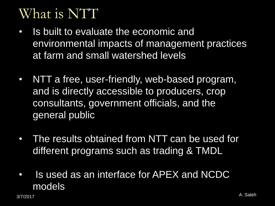
What is NTT• Is built to evaluate the economic and
environmental impacts of management practices
at farm and small watershed levels
• NTT a free, user-friendly, web-based program,
and is directly accessible to producers, crop
consultants, government officials, and the
general public
• The results obtained from NTT can be used for
different programs such as trading & TMDL
• Is used as an interface for APEX and NCDC
models3/7/2017 A. Saleh

How does NTT work?
• Uses Agricultural Policy Environmental eXtender
(APEX) to determine nutrient and sediment losses and
runoff from agricultural fields
• Uses the Farm Economic Model (FEM) to assess the
cost/benefit of farm management practices
• A web-based program that requires no software
installation
• Transparent and easy to use
3/7/2017 A. Saleh

Field and Farm Linkage: NTT
• Ability of connecting the fields in the farm by APEX routing function

Current NTT Applications
3/7/2017 A. Saleh

Science
A. Saleh

APEX (0806)
• APEX 0806 (Dr. Jimmy Williams) with TIAER modifications
• APEX was developed by USDA scientists to predict the effects of different management scenarios on water quality, sediment yields, and pollutant loading from various landuseswithin fields and small watersheds
3/7/2017 A. Saleh

Weather
Hydrology
Erosion (wind and water)
Nutrients (N, P, and K)
CO2
Pesticides
Crop growth
Tillage
Management
Routing
Reservoirs
Groundwater
Grazing
Manure management
Components of Environmental models

• No-till • Contour farming
• Mulch-till • Critical area planting
• Prescribed grazing • Pasture planting
• Riparian forest buffer
• Forestry
• Grassed waterways
• Filter strips
• Terrace
• Range planting
• Field Border
• Fence
• Pipelines
• Nutrient management
• Brush management
• Grade stabilization structure
• Pest management
• Conservation crop rotation
• Wetland creation or enhancement
NRCS Conservation Practices (CPs) Evaluated
in NTT

Input and Output Databases
A. Saleh

Databases
• Weather files• 4-KM2 resolution up to Dec-2014 (PRZM data)
• Soil Data• USDA-NRCS soil survey (SURGO) databases hosted in
NTT site (modified every six month) and debugged automatically before used in NTT
• Ability to modify or create the soil (up to 10 layers)
• Slope calculation using the 10-m DEM resolution
• Economic data and for simulation of FEM
• Capability of users to input their own data basis
3/7/2017 A. Saleh

Output
• Model outputs under Baseline and BMP’s regimes
• N, P, C, Pesticide, Herbicides, and Sediment at different forms and sources
• Crop yield
• Obtaining results at the edge of individual and combined field(s) (sub-watershed) and farm (watershed)
• results of single or multiple scenarios (e.g., Nutrient management and filter strips)
• Graphics
• PDF report3/7/2017 A. Saleh

Interface
A. Saleh

• Fast (fraction of a sec per year of simulation)• Easy steps to create and simulate program• Capability of users to input their own data basis• Ability to modify the parameters for calibration
within the program• Ability to download the project and associated
APEX files• English and Spanish Languages• Electronic help for NTT and associated programs
(e.g., APEX) in English and Spanish languages
3/7/2017 A. Saleh
Accessibility

Selection of Area of Interest (AOI)Interface
• State and County data basis• Google map rather Soil Survey Site• Faster surfing the map• Selection of multiple fields (sub-watersheds) within a
farm (watershed)• Using Shape files to select the AOI• Using longitude and latitude or address to select the
AOI• Ability to obtain the land use data • View the picture of the AOI (if available by GOOGLE
MAP)
3/7/2017 A. Saleh

Project Properties

Area of Interest (AOI) Selection

Weather
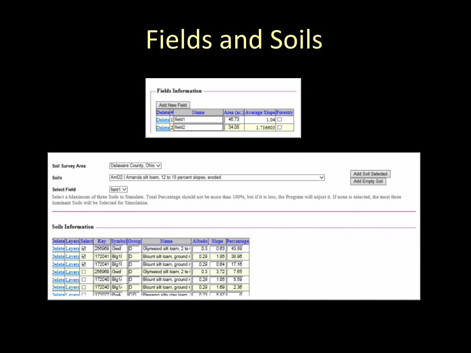
Fields and Soils

Soils Detailed Layers

Management Screen

Simulation Screen

Detailed Result Summary

Graphs – Monthly – Annual

NTT as an APEX Interface
A. Saleh
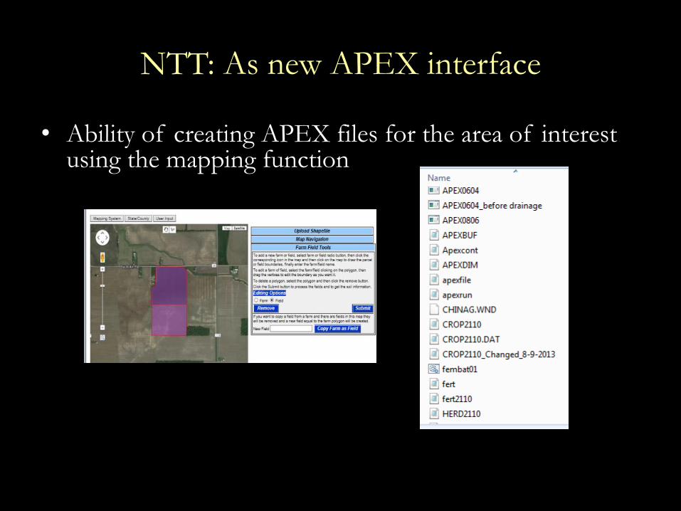
NTT: As new APEX interface
• Ability of creating APEX files for the area of interest using the mapping function

NTT: As new APEX interface
• Ability of modify files (e.g., Parm) and calibrate APEX using NTT program

Current NTT Enhancements
• Working with our colleagues at USDA to create a version of New NTT Program for USDA Trading program
• Incorporation of Forestry management practices
• Assist international users to adopt NTT at their region
• Completion of Economic data for all US for FEM simulation in NTT and CEEOT (Comprehensive Economic and Environmental Optimization Tool) programs
3/7/2017 A. Saleh

Environmental and Economic impacts of CPs on Crop Yield and
Water quality and Quantity

CEEOT and NTT Intergraded Programs
SWAT (Watershed Model)
APEX (Field scale model)
FEM (Farm Economic
Model)
CEEOT(Farm and
Watershed Scales) NTT (Farm Scale)

A. Saleh


An Example of the Economic Simulation Result Screen
A. Saleh

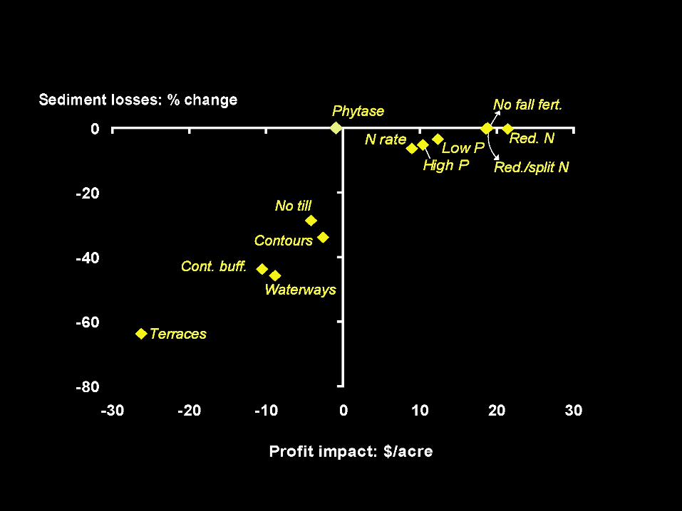
Expected Environmental Results
Lake Earie Region
A. Saleh

Results from site EOF-WGS841: “BASELINE” and “NUTRIENT SUBAPPLICATION” Scenarios

Results from site EOF-WGS842: “BASELINE” and “NUTRIENT SUBAPPLICATION” Scenarios

NTT Results from site DF-22: “CS_NOTILL” and “CS_NOTILL_NO TILE” Scenarios
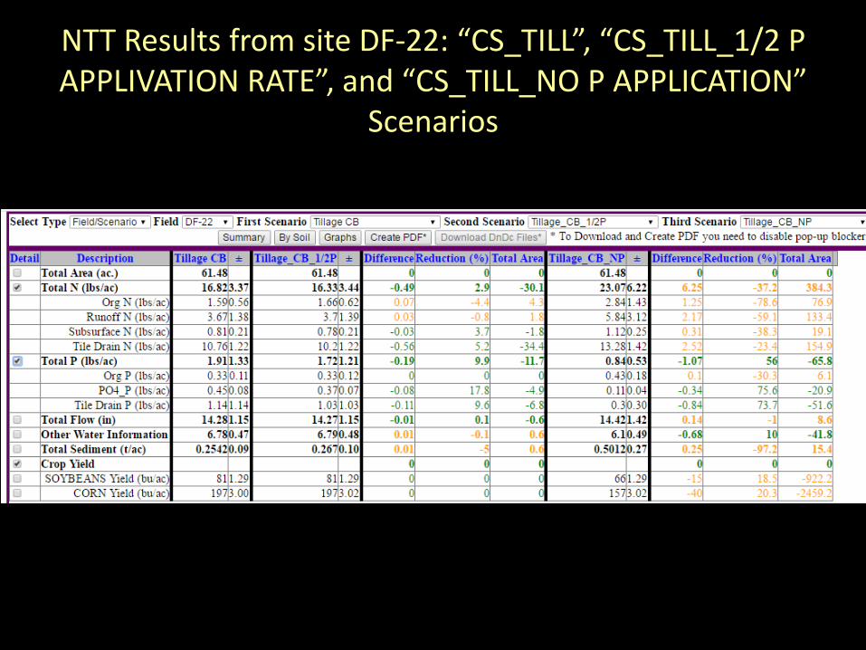
NTT Results from site DF-22: “CS_TILL”, “CS_TILL_1/2 P APPLIVATION RATE”, and “CS_TILL_NO P APPLICATION”
Scenarios

NTT Results from site DF-22: “CS_TILL”, “CS_NOTILL”, AND “CS_NOTILL_SUBAPPLICATION” Scenarios
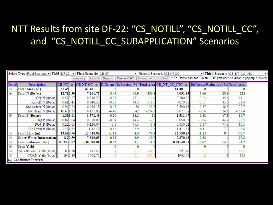
NTT Results from site DF-22: “CS_NOTILL”, “CS_NOTILL_CC”, and “CS_NOTILL_CC_SUBAPPLICATION” Scenarios

Question and Comments
Thanks