Norwegian Shelf - Internal wave€¦ · An Atlas of Oceanic Internal Solitary Waves (February 2004)...
10
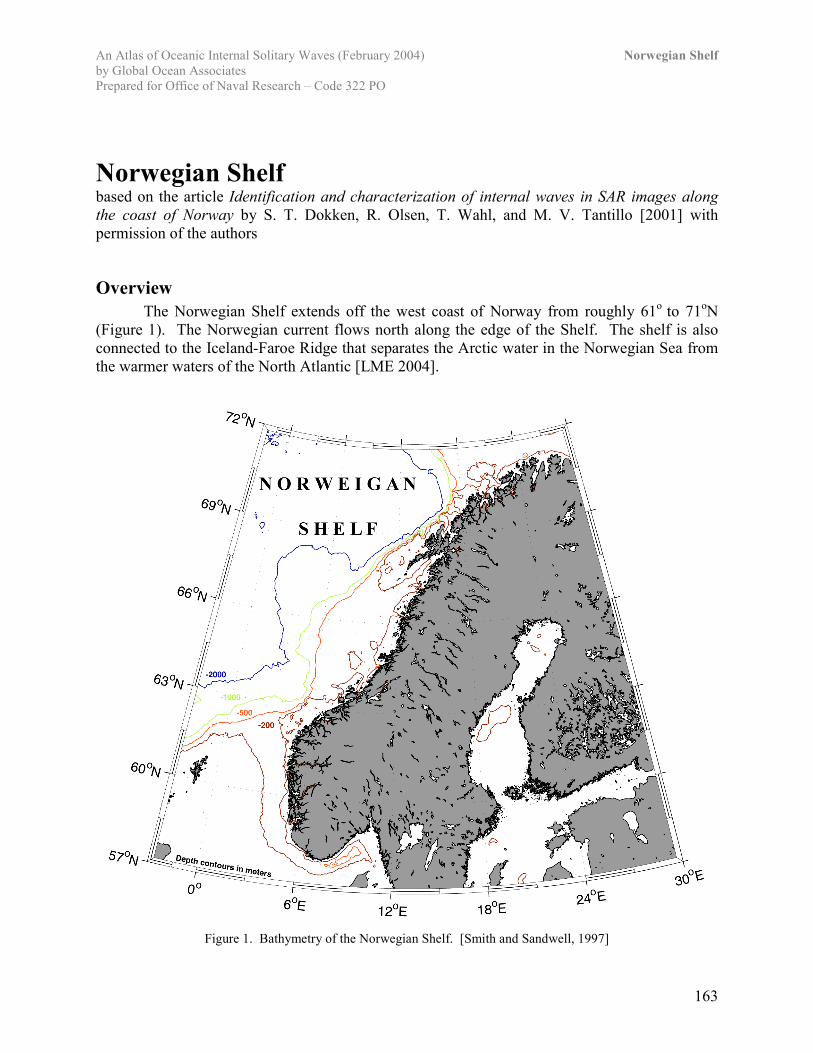
An Atlas of Oceanic Internal Solitary Waves (February 2004) Norwegian Shelf by Global Ocean Associates Prepared for Office of Naval Research – Code 322 PO 163 Norwegian Shelf based on the article Identification and characterization of internal waves in SAR images along the coast of Norway by S. T. Dokken, R. Olsen, T. Wahl, and M. V. Tantillo [2001] with permission of the authors Overview The Norwegian Shelf extends off the west coast of Norway from roughly 61 o to 71 o N (Figure 1). The Norwegian current flows north along the edge of the Shelf. The shelf is also connected to the Iceland-Faroe Ridge that separates the Arctic water in the Norwegian Sea from the warmer waters of the North Atlantic [LME 2004]. Figure 1. Bathymetry of the Norwegian Shelf. [Smith and Sandwell, 1997]
Transcript of Norwegian Shelf - Internal wave€¦ · An Atlas of Oceanic Internal Solitary Waves (February 2004)...
An Atlas of Oceanic Internal Solitary Waves (February 2004) Norwegian Shelfby Global Ocean AssociatesPrepared for Office of Naval Research – Code 322 PO
163
Norwegian Shelfbased on the article Identification and characterization of internal waves in SAR images alongthe coast of Norway by S. T. Dokken, R. Olsen, T. Wahl, and M. V. Tantillo [2001] withpermission of the authors
OverviewThe Norwegian Shelf extends off the west coast of Norway from roughly 61o to 71oN
(Figure 1). The Norwegian current flows north along the edge of the Shelf. The shelf is alsoconnected to the Iceland-Faroe Ridge that separates the Arctic water in the Norwegian Sea fromthe warmer waters of the North Atlantic [LME 2004].
Figure 1. Bathymetry of the Norwegian Shelf. [Smith and Sandwell, 1997]
An Atlas of Oceanic Internal Solitary Waves (February 2004) Norwegian Shelfby Global Ocean AssociatesPrepared for Office of Naval Research – Code 322 PO
164
ObservationsInternal wave activity along the Norwegian Shelf occurs mainly in four "hot-spot" areas
each with distinctive characteristic. These areas include Egga, Moskenes, the Vøring plateau,and the Norwegian Trench. The internal waves occur most frequently in the late summer, whenthermal stratification is most pronounced and wind conditions are moderate.
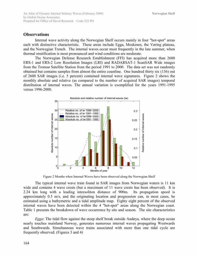
The Norwegian Defense Research Establishment (FFI) has acquired more than 2600ERS-1 and ERS-2 Low Resolution Images (LRI) and RADARSAT-1 ScanSAR Wide imagesfrom the Tromsø Satellite Station from the period 1991 to 2000. The data set was not randomlyobtained but contains samples from almost the entire coastline. One hundred thirty six (136) outof 2600 SAR images (i.e. 5 percent) contained internal wave signatures. Figure 2 shows themonthly absolute and relative (as compared to the number of acquired SAR images) temporaldistribution of internal waves. The annual variation is exemplified for the years 1991-1995versus 1996-2000.
Figure 2 Months when Internal Waves have been observed along the Norwegian Shelf
The typical internal wave train found in SAR images from Norwegian waters is 11 kmwide and contains 4 wave crests (but a maximum of 11 wave crests has been observed). It is2.24 km long with a leading intersoliton distance of 900m. Its propagation speed isapproximately 0.5 m/s, and the originating location and progression can, in most cases, beestimated using a bathymetric and a tidal amplitude map. Eighty eight percent of the observedinternal waves have been detected within the 4 "hot-spot" areas along the Norwegian coast.Table 1 presents the breakdown of wave occurrence by site and season. The site characteristicsare:
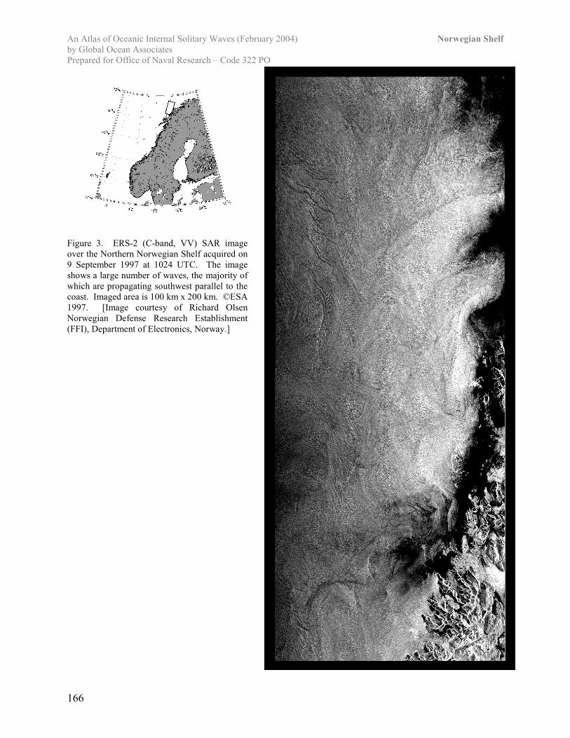
Egga: The tidal flow against the steep shelf break outside Andøya, where the deep oceannearly touches mainland Norway, generates numerous internal waves propagating Westwardsand Southwards. Simultaneous wave trains associated with more than one tidal cycle arefrequently observed. (Figures 3 and 4)
An Atlas of Oceanic Internal Solitary Waves (February 2004) Norwegian Shelfby Global Ocean AssociatesPrepared for Office of Naval Research – Code 322 PO
165
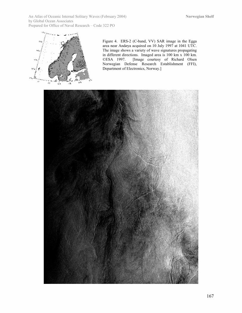
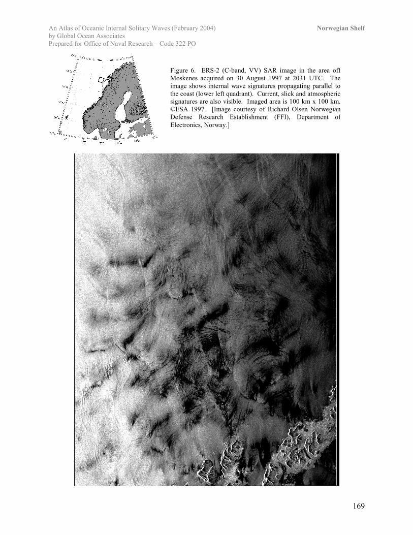
Moskenes: The strong tidal current called the Maelstrøm resides in the Moskenes Sound,located in Lofoten between Moskenesøy and Værøy [Gjevik et al., 1997]. The tidal flow can becharacterized into eight different cases [Dokken and Wahl, 1996], and the 1/2 low and 3/4 lowtide situations generate westward propagating internal waves when the outgoing jet from theMoskenes sound is deflected towards North. Observations and laboratory experiments[McClimans, 1997] substantiate that internal waves cannot be sustained at the eastern part of theMoskenes Sound because of tidal destruction of the ocean stratification. The average middle tideheight difference for the area is 174 cm per year [Nordanger Forlag, 1995]. (Figures 5 and 6)
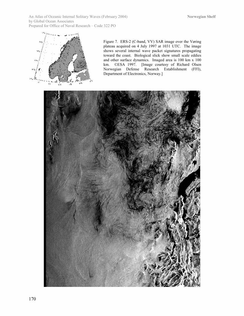
The Vøring plateau: Located at a depth of 1300m, the almost circular shaped Vøringplateau generates internal waves with small front curvatures in the summer season all around theplateau's edges. (Figure 7)
The Norwegian Trench: The internal waves propagate in the Northeast direction along theedges of the end of the Norwegian Trench (i.e. Vestfold). They are observed to be dispersive,having a small front curvature, though quite irregularly shaped. They are believed to be tidallygenerated, although the tidal amplitude is low in this area (typically 20 cm) [Nordanger Forlag,1995]. The tidal flow is assumed to influence the stability of the pycnocline above the trench'sslopes, and thereby generate the internal waves. This explains the higher temporal occurrence inthe summer months associated with a stronger pycnocline, although the SAR internal wavemanifestations are reduced in stormy and turbulent winter weather. (See the case study of theNorth Sea). The beginning of the trench (i.e. Hordaland) frequently generates dispersive internalwaves with relatively large front curvatures.
Location Numberobserved
Season (%);spring-summer-autumn-winter
Dispersivity (%):yes-little-no
The Norwegian Trench:StartEnd
642535
28-48-20-432-60-4-4
20-43-34-3
68-29-380-20-060-37-3
Vøring 21 0-100-0-0 65-35-0
Moskenes 11 0-82-18-0 0-100-0
Egga 62 13-50-35-2 79-21-0
Elsewhere 31 16-45-32-7 50-50-0
Table 1: The location of detected internal waves along the coast of Norway.
An Atlas of Oceanic Internal Solitary Waves (February 2004) Norwegian Shelfby Global Ocean AssociatesPrepared for Office of Naval Research – Code 322 PO
166
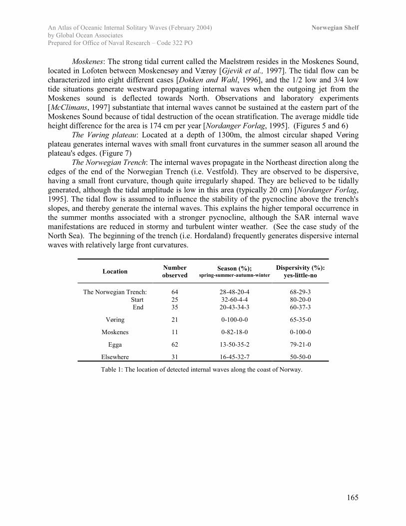
Figure 3. ERS-2 (C-band, VV) SAR imageover the Northern Norwegian Shelf acquired on9 September 1997 at 1024 UTC. The imageshows a large number of waves, the majority ofwhich are propagating southwest parallel to thecoast. Imaged area is 100 km x 200 km. ©ESA1997. [Image courtesy of Richard OlsenNorwegian Defense Research Establishment(FFI), Department of Electronics, Norway.]
An Atlas of Oceanic Internal Solitary Waves (February 2004) Norwegian Shelfby Global Ocean AssociatesPrepared for Office of Naval Research – Code 322 PO
167
Figure 4. ERS-2 (C-band, VV) SAR image in the Eggaarea near Andøya acquired on 10 July 1997 at 1041 UTC.The image shows a variety of wave signatures propagatingin different directions. Imaged area is 100 km x 100 km.©ESA 1997. [Image courtesy of Richard OlsenNorwegian Defense Research Establishment (FFI),Department of Electronics, Norway.]
An Atlas of Oceanic Internal Solitary Waves (February 2004) Norwegian Shelfby Global Ocean AssociatesPrepared for Office of Naval Research – Code 322 PO
168
Figure 5. ERS-2 (C-band, VV) SAR image inthe area between Egga and Moskenes acquiredon 18 June 1997 at 1033 UTC. The upper halfof the image shows internal wave signaturespropagating parallel to the coast in addition tocurrent signatures. Near Mokenes (lower left)several packets can be seen propagating awayfrom shore. Imaged area is 100 km x 200 km.©ESA 1997. [Image courtesy of Richard OlsenNorwegian Defense Research Establishment(FFI), Department of Electronics, Norway.]
An Atlas of Oceanic Internal Solitary Waves (February 2004) Norwegian Shelfby Global Ocean AssociatesPrepared for Office of Naval Research – Code 322 PO
169
Figure 6. ERS-2 (C-band, VV) SAR image in the area offMoskenes acquired on 30 August 1997 at 2031 UTC. Theimage shows internal wave signatures propagating parallel tothe coast (lower left quadrant). Current, slick and atmosphericsignatures are also visible. Imaged area is 100 km x 100 km.©ESA 1997. [Image courtesy of Richard Olsen NorwegianDefense Research Establishment (FFI), Department ofElectronics, Norway.]
An Atlas of Oceanic Internal Solitary Waves (February 2004) Norwegian Shelfby Global Ocean AssociatesPrepared for Office of Naval Research – Code 322 PO
170
Figure 7. ERS-2 (C-band, VV) SAR image over the Vøringplateau acquired on 4 July 1997 at 1031 UTC. The imageshows several internal wave packet signatures propagatingtoward the coast. Biological slick show small scale eddiesand other surface dynamics. Imaged area is 100 km x 100km. ©ESA 1997. [Image courtesy of Richard OlsenNorwegian Defense Research Establishment (FFI),Department of Electronics, Norway.]
An Atlas of Oceanic Internal Solitary Waves (February 2004) Norwegian Shelfby Global Ocean AssociatesPrepared for Office of Naval Research – Code 322 PO
171
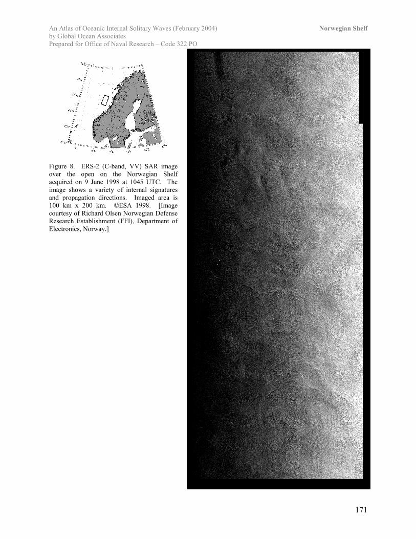
Figure 8. ERS-2 (C-band, VV) SAR imageover the open on the Norwegian Shelfacquired on 9 June 1998 at 1045 UTC. Theimage shows a variety of internal signaturesand propagation directions. Imaged area is100 km x 200 km. ©ESA 1998. [Imagecourtesy of Richard Olsen Norwegian DefenseResearch Establishment (FFI), Department ofElectronics, Norway.]
An Atlas of Oceanic Internal Solitary Waves (February 2004) Norwegian Shelfby Global Ocean AssociatesPrepared for Office of Naval Research – Code 322 PO
172
ReferencesDokken, S. T., R. Olsen, T. Wahl, and M. V. Tantillo, 2001: Identification and characterization
of internal waves in SAR images along the coast of Norway. Geophys. Res. Lett., 28, 2803–2806.
Dokken, S. T. and T. Wahl. ERS SAR Observations of Tidal Currents in the Moskenes Sound.FFI/Rapport -95/04882, Forsvarets Forskningsinstitutt, 1995.
Gjevik, B., H. Moe and A. Ommundsen. Sources of the Maelstrom. Nature, 388, 1997.Large Marine Ecosystems of the World: LME #21: Norwegian Shelf Large Marine Ecosystem;
January 2004, http://na.nefsc.noaa.gov/lme/text/lme21.htmMcClimans, T. Personal Communication. SINTEF Civil and Environmental Engineering, 1997.Nordanger Forlag. Den norske almanakk og kystkalender 1995. ISBN 82-7051-096-3, 1995.Smith, W. H. F., and D. T. Sandwell, Global seafloor topography from satellite altimetry and
ship depth soundings, Science, v. 277, p. 1957-1962, 26 Sept., 1997.http://topex.ucsd.edu/marine_topo/mar_topo.html