Tectonics and basin evolution of the Norwegian shelf...
27
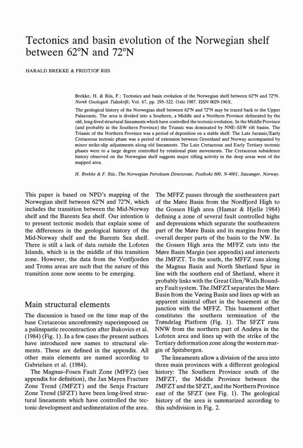
Tecton i cs an d bas i n evolut i on of the Norweg i an shelf between 62°N an d 72°N HARALD BREKKE & FRIDTJOF RIIS Brekke, H. & Riis, F.: Tectonics and basin evolution of the Norwegian shelf between 62°N and n•N. Nok Geologk Tiskri f t, Vol. 67, pp. 29322. Oslo 1987. ISSN 29-196X. The geological history of the Norwegian shelf between 62°N and n•N may be traced back to the Upper Palaeozoic. The area is divided into a Southern, a Middle and a Northern Province delineated by the old, long-Iived structural lineaments which have controlled the tectonic evolution. In the Middle Province (and probably in the Southern Province) the Triassic was dominated by NNE-SSW rift basins. The Triassic of the Northern Province was a peri of deposition on a stable shelf. The Late Jurassic/Early Cretaceous tectonic phase was a period of extension between Greenland and Norway accompanied by minor strike-slip adjustments along old lineaments. The Late Cretaceous and Early Tertiary tectonic phases were to a large degree controlled by rotational plate movements. The Cretaceous subsidence history observed on the Norwegian shelf suggests major rifting activity in the deep areas west of the mapped area. H. Brekke & F. Ri, The Norwegian Petroleum Directorate, Postbo <0, N-(01, Stavanger, Norway. This paper is based on NPD's mapping of the Norwegian shelf between 62°N and 72°N, which includes the transition between the Mid-Norway shelf and the Barents Sea shelf. Our intention is to present tectonic models that explain some of the differences in the geological history of the Mid-Norway shelf and the Barents Sea shelf. There is still a Jack of data outside the Lofoten Islands, which is in the middle of this transition zone. However, the data om the Vestfjorden and Troms areas are such that the nature of this transition zone now seems to be emerging. Main structural element s The discussion is based on the time map of the base Cretaceous unconfoty superimposed on a palinspastic reconstruction aſter Bukovics et al. (1984) (Fig. 1). In a few cases the present authors have introduced new names to structural ele- ments. These are defined in the appendix. All other main elements are named according to Gabrielsen et al. (1984). The MagnuFosen Fault Zone (MFFZ) (see appendix for definition), the Jan Mayen Fracture Zone Trend (JMFZT) and the Senja Fracture Zone Trend (SFZT) have been long-lived struc- tural lineaments which have controlled the tec- tonic development and sedimentation of the area. The MFFZ passes through the southeastern part of the Møre Basin from the Nordfjord High to the Gossen High area (Hamar & Hjelle 1984) defining a zone of several fault controlled highs and depressions which separate the southeastern part of the Møre Basin and its margins from the overall deeper parts of the basin to the NW. In the Gossen High area the MFFZ cuts into the Møre Basin Margin (see appendix) and intersects the JMFZT. To the south, the MFFZ runs along the Magnus Basin and North Shetland Spur in line with the southern end of Shetland, where it probably links with the Great Glen/Walls Bound- ary Fault system. The JMFZT separates the Møre Basin om the Vøring Basin and lines up with an apparent sinistral offset in the basement at the junction with the MFFZ. This basement offset constitutes the southern termination of the Trøndelag Platform (Fig. 1). The SFZT runs NNW from the northern part of Andøya in the Lofoten area and lines up with the strike of the Tertiary deformation zone along the western mar- gin of Spitsbergen. The lineaments allow a division of the area into three main provinces with a different geological history: The Southern Province south of the JMFZT, the Middle Province between the JMFZT and the SFZT, and the Northern Province east of the SFZT (see Fig. 1). The geological history of the area is summarized according to this subdivision in Fig. 2.
Transcript of Tectonics and basin evolution of the Norwegian shelf...
Tectonics and basin evolution of the Norwegian shelf between 62°N and 72°N HARALD BREKKE & FRIDTJOF RIIS
Brekke, H. & Riis, F.: Tectonics and basin evolution of the Norwegian shelf between 62°N and n•N. Norsk Geologisk Tidsskrift, Vol. 67, pp. 295-322. Oslo 1987. ISSN 0029-196X.
The geological history of the Norwegian shelf between 62°N and n•N may be traced back to the Upper Palaeozoic. The area is divided into a Southern, a Middle and a Northern Province delineated by the old, long-Iived structural lineaments which have controlled the tectonic evolution. In the Middle Province (and probably in the Southern Province) the Triassic was dominated by NNE-SSW rift basins. The Triassic of the Northern Province was a period of deposition on a stable shelf. The Late Jurassic/Early Cretaceous tectonic phase was a period of extension between Greenland and Norway accompanied by minor strike-slip adjustments along old lineaments. The Late Cretaceous and Early Tertiary tectonic phases were to a large degree controlled by rotational plate movements. The Cretaceous subsidence history observed on the Norwegian shelf suggests major rifting activity in the deep areas west of the mapped area.
H. Brekke & F. Riis, The Norwegian Petroleum Directorate, Postboks 600, N-4001, Stavanger, Norway.
This paper is based on NPD's mapping of the Norwegian shelf between 62°N and 72°N, which includes the transition between the Mid-Norway shelf and the Barents Sea shelf. Our intention is to present tectonic models that explain some of the differences in the geological history of the Mid-Norway shelf and the Barents Sea shelf. There is still a Jack of data outside the Lofoten Islands, which is in the middle of this transition zone. However, the data from the Vestfjorden and Troms areas are such that the nature of this transition zone now seems to be emerging.
Main structural element s
The discussion is based on the time map of the base Cretaceous unconforrnity superimposed on a palinspastic reconstruction after Bukovics et al. (1984) (Fig. 1). In a few cases the present authors have introduced new names to structural elements. These are defined in the appendix. All other main elements are named according to Gabrielsen et al. (1984).
The Magnus-Fosen Fault Zone (MFFZ) (see appendix for definition), the Jan Mayen Fracture Zone Trend (JMFZT) and the Senja Fracture Zone Trend (SFZT) have been long-lived structural lineaments which have controlled the tectonic development and sedimentation of the area.
The MFFZ passes through the southeastern part of the Møre Basin from the Nordfjord High to the Gossen High area (Hamar & Hjelle 1984) defining a zone of several fault controlled highs and depressions which separate the southeastern part of the Møre Basin and its margins from the overall deeper parts of the basin to the NW. In the Gossen High area the MFFZ cuts into the Møre Basin Margin (see appendix) and intersects the JMFZT. To the south, the MFFZ runs along the Magnus Basin and North Shetland Spur in line with the southern end of Shetland, where it probably links with the Great Glen/Walls Boundary Fault system. The JMFZT separates the Møre Basin from the V øring Basin and lines up with an apparent sinistral offset in the basement at the junction with the MFFZ. This basement offset constitutes the southern termination of the Trøndelag Platform (Fig. 1). The SFZT runs NNW from the northern part of Andøya in the Lofoten area and lines up with the strike of the Tertiary deformation zone along the western margin of Spitsbergen.
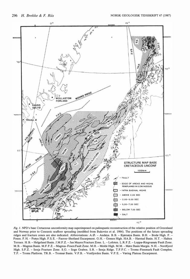
The lineaments allow a division of the area in to three main provinces with a different geological history: The Southern Province south of the JMFZT, the Middle Province between the JMFZT and the SFZT, and the Northern Province east of the SFZT (see Fig. 1). The geological history of the area is summarized according to this subdivision in Fig. 2.
296 H. Brekke & F. Riis
o o
NORSK GEOLOGISK TIDSSKRIFr 67 (1987)
100km
- FAULT
- EOGE OF AREAS AND HIGHS PENEPLAINEO IN E.CRETACEOUS
- ! NTRA BAS! NAL HIGHS - ABOVE 2.00 SEC - 2.00-5,00 SEC
- 5,00-7.00 SEC
- BELOW 7.00 SEC
-SALT
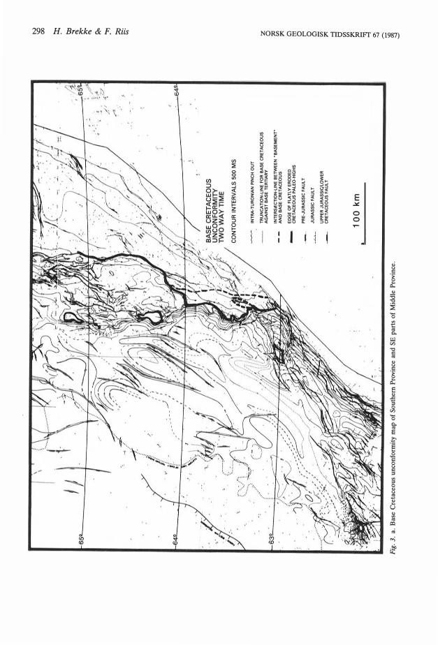
Fig. l. NPD's base Cretaceous unconformity map superimposed on palinspastic reconstruction of the relative position of Greenland and Norway prior to Cenozoic seafloor spreading (modified from Bukovics et al. 1984). The positions of the future spreading ridges and fracture zones are also indicated. Abbreviations: A. Ø.- Andøya. B.B.- Bjørnøya Basin. B.H.- Bodø High. F. Fosen. F.H.- :Frøya High. F. S.E.- Faeroe-Shetland Escarpment. G.H.- Gossen High. HA.B. - Harstad Basin. H. T. - Halten Terrace. H.B.- Helgeland Basin. J.M. F.Z.- Jan Mayen Fracture Zone. L. - Lofoten. L. R.F.Z. - Loppa-Ringvassøy Fault Zone. M.B.- Magnus Basin. M. F.F.Z.- Magnus-Fosen Fault Zone. M.H.- Molde High. M.M. - Møre Basin Margin. N .H.- Nordfjord High. S. F.Z. - Senja Fracture Zone. S.G. - Sogn Graben. S. R. - Senja Ridge. T. F.F.C. - Troms-Finnmark Fault Complex. T.P.- Troms Platform. TR.B.- Tromsø Basin. V. F.B. - Vestfjorden Basin. V.P.E.- V øring Plateau Escarpment.
NORSK GEOLOGISK TIDSSKRIFT 67 (1987) TSGS Symposium 1986 297
T
c
J
p
c
Ml
f-OL
f--EO
L
E
L f--
M
E
L
TAMPEN-JAN MAYEN F.Z. JAN MAYEN F.Z.-SENJA F.Z. NORTH OF SENJA F Z RIFTI STRUCTURAL OEPOSIT10f\ ;J-���1Z1 RIFT l STRUCTURAl OEPOSITION ;f6;�11�1 RIFT l STRUCTURAL DEPOSITIOr. ;e
L6i���T HASE EXPRESSION CENTRE PROVENAN.fHASE EXPRESSION CENTRE PROVENAN. HASEEXPRESSION CENTRE PROVENAN.
TRANS-) RESSIONAL OMES AND A SIN$ ROSION UPLIFT
MINOR TRANS PRESSIONAL OOMES & BASINS
TRANSGRESSION MASSIVE SUBSIDENCE
EROSIQN OF MARGINAL AND BASif\IAL HIGH$
I.JPUFT
tNTENSE BLOCK FAULTING AND GRAS EN
l ��
e�g��
ENT
TRANSPRESSIONAL DOM ING
EAST MØRE EASTERN BA SIN
NE MØRE BA SIN
MØRE BA SIN
MØRE BASIN
MØRE BAS IN
MARGIN
EASTERN MARGIN
MARGINAL & BASINAL HIGHS
MARGINAL & IASINAL HIGHS
FROM SOUTH &?
EAST
FROM SOUTH SW & EAS
TRANSPRESSIONAL
1l ������ AND•
EROSION UPUFT
) DIFFERENTIAL UPLIFT OF NORD-
l ����T�����N OF EASTERN MARGIN OF HAL TEN TERRACE TRANSGRESSION MASSIVE SUBSIDENCE
EROSION OF MARGINAL AND BASINAL HIGHS FRINGING CANYONS UPUFT
\ �NATUEL��;G
s��g
K
GRA BEN DEVElOPM. AND SOME TRANSPRESSIONAL DOMING
MØRE BA SIN? �6��H & r
EASTERN MARGIN
FRØYA HIGH
VØRING BA SIN
V ØRING BASIN
V ØRING & VESTFJORDEN BAS! NS
EASTERN MARGIN
EASTERN MARGIN
MARGINAL & BASINAL HIGHS
MARGINAL & BASINAL HIGHS
GR ASEN MARGINS
ROM EAS & GRABEN MARGINS
FROM EAST
HELGELAN GRABEN 1 VØRING MARGINS
l OEEP EROSION UPLIFT �1 INTRUSIONS
?
OOMING l FAUL TING
DOMING FAUL TING EROSION OF '\. HIGHS UPUFT
�/Il THR�:����N�
EROSION OF HIGHS UPLIFT ��� BLO
�:Ul TING
1 BLOCK FAUL TING
� TRANSGRESSION UPLIFT TRANSGRESSION
TROMSØ BA SIN
HARSTAD BA SIN AND
WEST OF SENJA RIDGE
- ? GAABEN ACTIVITY ALONG VIKING GRABEN TREND AND EAST
EAST & ! \ WEST MARGINS?
EROSION UPUFT BLOCK FAUL TING ? VESTFJ.
LOPPA HIGH AREA
M T
L -E
E
SHETLAND
OEEP EROSION UPliFT
7 BLOCK
l
FAUL TING
BLOCK FAULTING
? ?
? ?
GRA BEN DEVELOPM.
DEEP EROSION ) UPLIFT BLOCK FAUL TING GRABEN DEVELOPM.
1l
BASINS
?
.;..:�ANSGRESSION �f BASEMENT IGHS ) BLOCK FAUL TIN
l� RANSGRESSION
OF BASEMENT HIGHS
SALT ?SLOCK FAUL TING
TROMSØ BA SIN
Fig. 2. Tectono-sedimentary summary of the Norwegian shelf between 62° and 72°N, according to the proposed areal subdivision
(see text).
l' l
: 11
./iJ/
J.. 'l
l� ''
\1�
n;.',
Q>'I�
.. l\
;··/
/!..-;,-·
. /,
·.�
/
CON
TOU
R IN
TERV
ALS
500
MS
Fig.
3. a.
Bas
e C
reta
ceou
s un
conf
orm
ity
map
of
Sout
hem
Pro
vinc
e an
d SE
par
ts o
f M
iddl
e P
rovi
nce.
INT
RA
-TU
RO
NIA
N P
INC
H O
UT
TR
UN
CA
TIO
N-U
NE
FO
R B
AS
E C
RE
TA
CE
OU
S
AG
AIN
ST
BA
SE
TE
RT
IAR
Y
INT
ER
SlE
CT
ION
-LIN
E B
ElW
EE
N -"
8A
SE
ME
NT
'"
AN
D B
AS
E C
RE
TA
CE
OU
S
ED
GE
OF
FLA
TL
Y E
RO
OE
D
CR
ET
AC
EO
US
PA
LE
O-H
IGH
S
PR
E-J
UR
AS
SIC
FA
UL
T
JU
RA
SS
IC F
AU
L T
UP
PE
A J
UA
AS
SI<;IL
OW
EA
CR
ET
AC
EO
US
FA
UL
T
100
km
,.A
J }
N
\0
00 ;:t: t:x:l � � Ro
�
::o !:;: � � � � 5 8 Vl
� ::l o Vl
Vl � � ::J � ,.... �
67
°
·-61)
·T
•'•'
J1j
,-"
~--'/.
.~,
--.;
. J._7,.1~
.
,• V~
-.:~,,
_. ,r~
~ f
~
. )
• "•
•'
V
, 68
0--.
·':;.
....
l
y~ ~
· 1J
jlP
' ..
· ,;
.
' ·-
1
· ........
.... 9"
,.
. .. -:.;
.
. •' .·
_·.
·. '•
. .,..
; .. ·
· .. -
· /
•·..•
· .•• ·
,'
. ·•
..
-.
-.... ·!
.
.·
·_.$
~
-•
• -.~
•••
~· ~~ · .
. ·.
· .... ··~~
~~·
.... :
/
67
°
7/e:
i 1 .:> /1
) \/
~L~F1~7/~~"T-
p., "
;.:-
;;Jr<
_
66
°
~-ii!
~-~
lfr
~r~~r~~cr
-zr
. ,.,. ; ..,.
z o :;.:l
Vl ~
C'l m
o t"' o 8 Vl ~ ::l o Vl
Vl ~ ~ a- ...., ~ .... '(
)
ao ~ ~ ~ ~
~ Sl ~·
...... ~ ~
'-0
300 H. Brekke & F. Riis
+
····
····
�J!i .··
·.
ti O o
..
,oG� .. ·······
�"' �····
"'o" ...
············
.. ·····
..
·····
········
· ····
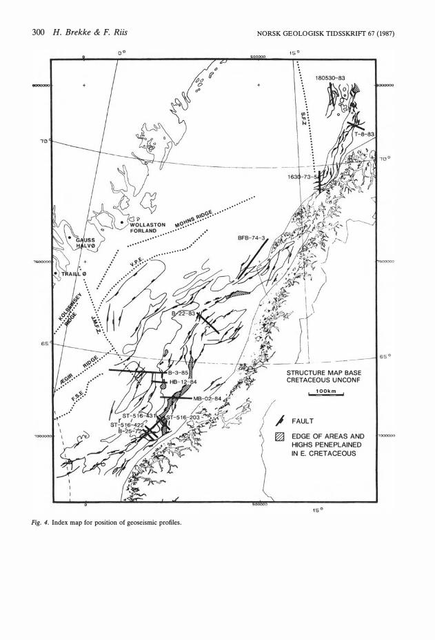
Fig. 4. Index map for position of geoseismic profiles.
. . .
. ... ··
NORSK GEOLOGISK TIDSSKRIFf 67 (1987)
+
STRUCTURE MAP BASE CRETACEOUS UNCONF
100km
.l FAULT
� EDGE OF AREAS AND HIGHS PENEPLAINED IN E. CRET ACEOUS
000000
500000
NORSK GEOLOGISK TIDSSKRIFr 67 (1987)
The Southern Province ( 62°N -JMFZT )
The Møre Basin The Møre Basin is essentially a Cretaceous basin. It is bounded by the northem termination of the Tampen Spur to the south, the JMFZT to the north, the Møre Basin Margin to the east and the eastern limit of early Tertiary basalts to the west (Figs. l and 3a). The basalts mask most of the seismic information from pre-Tertiary levels below, so it is uncertain where the Cretaceous western margin of the Møre Basin was situated. However, the basalt front probably coincides with the Paleocene shoreline along which the eastward flowing flood-basalts stopped (Smythe et al. 1983) There are also indications of large rotated fault blocks along this line (Bøen et al. 1984). Hence, the subaerial Paleocene basalts probably flowed across and deposited on a platform area that bounded the Møre Basin to the west through Cretaceous times.
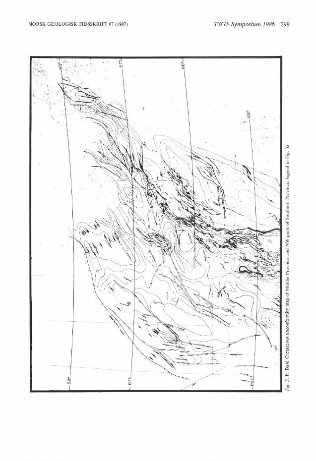
Taking the line of the basalt front as the western boundary of the Møre Basin implies that the Møre Basin is narrower and deeper than the Vøring Basin. This difference is taken up by the JMFZT by an apparent sinistral offset. The basalt front (and the coincident Paleocene shoreline) also closely follows this offset (Fig. 3b).
The Møre Basin Margin The Møre Basin Margin is situated between 62°N and the Gossen High area and is essentially a westward tilted sub-Cretaceous sequence onlapped by Cretaceous sediments. The NE-SW faults along this margin have been defined as part of the Møre-Trøndelag Fault Zone (Gabrielsen et al. 1984). These faults generally downthrow to the east giving small Middle Jurassic to Lower Cretaceous half grabens along the margin. The later westerly tilting has rotated many of these faults to a very low angle present attitude. The tilting must have started in the earliest Cretaceous or latest Jurassic, as most of the Cretaceous sequence is seen to onlap the tilted margin. The downwarp is most pronounced in the south where the base Cretaceous unconformity plunges down to below 6 sec TWT in the Sogn Graben (Fig. 1).
The main zone of faulting in the Late Jurassic/ Early Cretaceous seems to have been along the line of the MFFZ, west of the tilted Møre Basin
TSGS Symposium 1986 301
56 TP - TOP PALEOCENE INTRA PALEOCENE
TC - TOP CRETACEOUS
s - INTRA SANTONIAN? T - INTRA TURONIAN
BC - BASE CRETACEOUS
TT - TOP TRIASSIC
us - UPPER SALT MT - MIDDLE TRIASSIC UNCONFORMITY
MP - MIDDLE PERMIAN UNCONFORMITY?
Fig. 5. Key and proposed ages for seismic horizons in the geoseismic sections from the Southern and Middle Provinces.
Margin itself. The MFFZ has a more easterly trend than the Møre Basin Margin and cuts into the tilted margin in the Gossen High area where it joins the Møre-Trøndelag Fault Zone as defined by Gabrielsen et al. (1984) (Fig. 1).
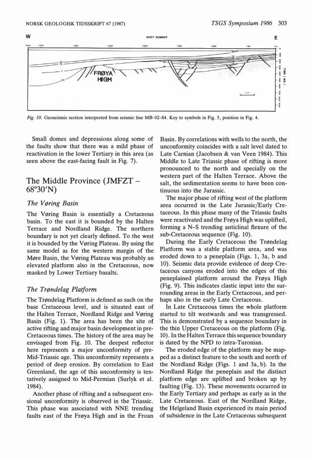
In the area around the Gossen High, the Møre Basin Margin is structurally complicated. This may be seen from the geoseismic sections in Figs. 6, 7, 8 and 9. Here, the JMFZT meets the MFFZ, creating a 'structural corner' which in the Late Jurassic became an area of very high extension. Highly rotated fault blocks are seen to have slid out on low-angle, shallow detachments in Late Jurassic /Early Cretaceous times, forming a core complex at base Cretaceous level (Fig. 8). The detachment partly follows a distinct reflector in the sub-Cretaceous sequence, speculatively interpreted as equivalent to the Mid-Permian unconformity on East Greenland (Surlyk et al. 1984). The core complex is interpreted as part of a complex rollover structure in the hanging wall to the main NW-SE trending fault along the southern termination of the Trøndelag Platform (Fig. 6). This fault is part of the JMFZT. The rollover is bounded to the east by the MFFZ along which it moved with an oblique, sinistral sense. An antithetic fault of the same phase of extension cuts parts of the core complex (Fig. 7).
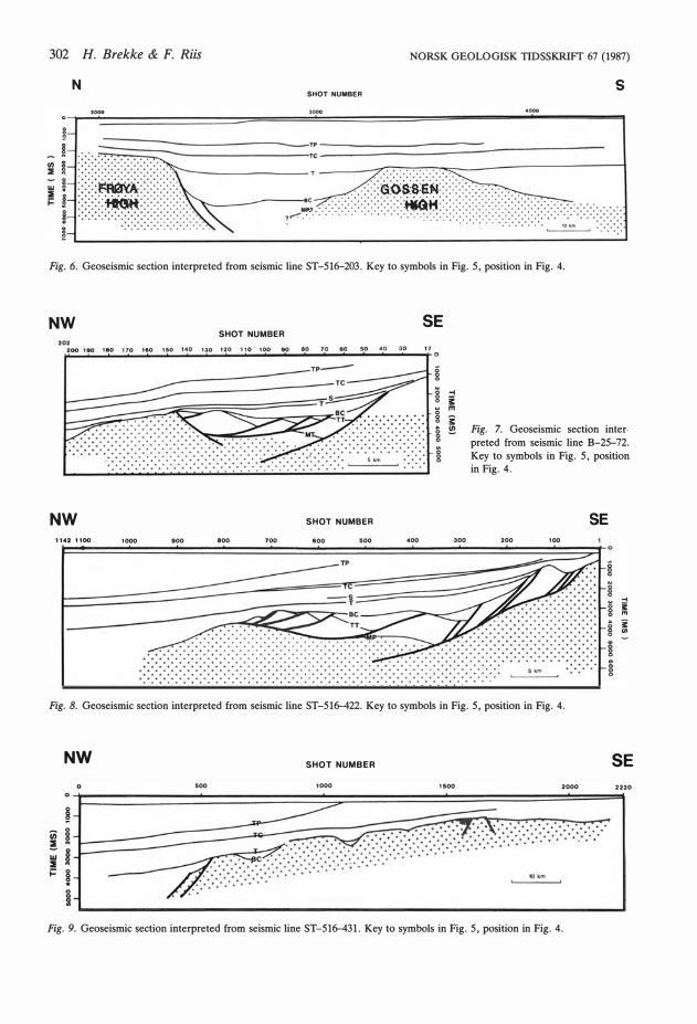
302 H. Brekke & F. Riis NORSK GEOLOGISK TIDSSKRIFr 67 (1987)
N s SHOT NUMBER
Fig. 6. Geoseismic section interpreted from seismic line S T-516-203. Key to symbols in Fig. 5, position in Fig. 4.
NW SE SHOT NUMBER
202 �2� 00�1o� o�1�80�1�7�0�1o�o�1�so� 1�4 0--�13�0 --12•o--'•1o __ •�oo��·�o --•.o--•'o--�•o ___ •.o __ •.o __ .3o---t1' o
� � 8 w g o
& o
i
E:=�;;;�����;;:===�����=��;:�i . �. <.:.:.:.:.:.:.: + • • • • • • • + •
• • + + + + . + + + +
..... :. :. :. :. ::::::::::::::::::::::::::::::::::::::::: �: � � \ � \::::::; �::::::: \ � \ � \ � NW SHOT NUMBER
1142 1100 1000 000 800 700 600 500 400
-1 � m i !!!
300
Fig. 7. Geoseismic section inter· preted from seismic line B-25--72. Key to symbols in Fig. 5, position in Fig. 4.
SE 200 100
o g § �
.... i m
g i o "' � 8 m
g
Fig. 8. Geoseismic section interpreted from seismic line S T-516-422. Key to symbols in Fig. 5, position in Fig. 4.
NW SHOT NUMBER SE 500 1000 1500 2000 2220
� ;;; o
! � Ill l :l i= �
o o 5I
Fig. 9. Geoseismic section interpreted from seismic line S T-516-431. Key to symbols in Fig. 5, position in Fig. 4.
NORSK GEOLOGISK TIDSSKRIFT 67 (1987) TSGS Symposium 1986 303
w SHOT NUMBER E
������ .. ! ! i � ' -•
Fig. JO. Geoseismic section interpreted from seismic line MB--02-84. Key to symbols in Fig. 5, position in Fig. 4.
Small domes and depressions along some of the faults show that there was a mild phase of reactivation in the lower Tertiary in this area (as seen above the east-facing fault in Fig. 7).
The Middle Province ( JMFZT -
68°30'N)
The V øring Basin The V øring Basin is essentially a Cretaceous basin. To the east it is bounded by the Halten Terrace and Nordland Ridge. The northern boundary is not yet clearly defined. To the west it is bounded by the V øring Plateau. By using the same model as for the western margin of the Møre Basin, the V øring Plateau was probably an elevated platform also in the Cretaceous, now masked by Lower Tertiary basalts.
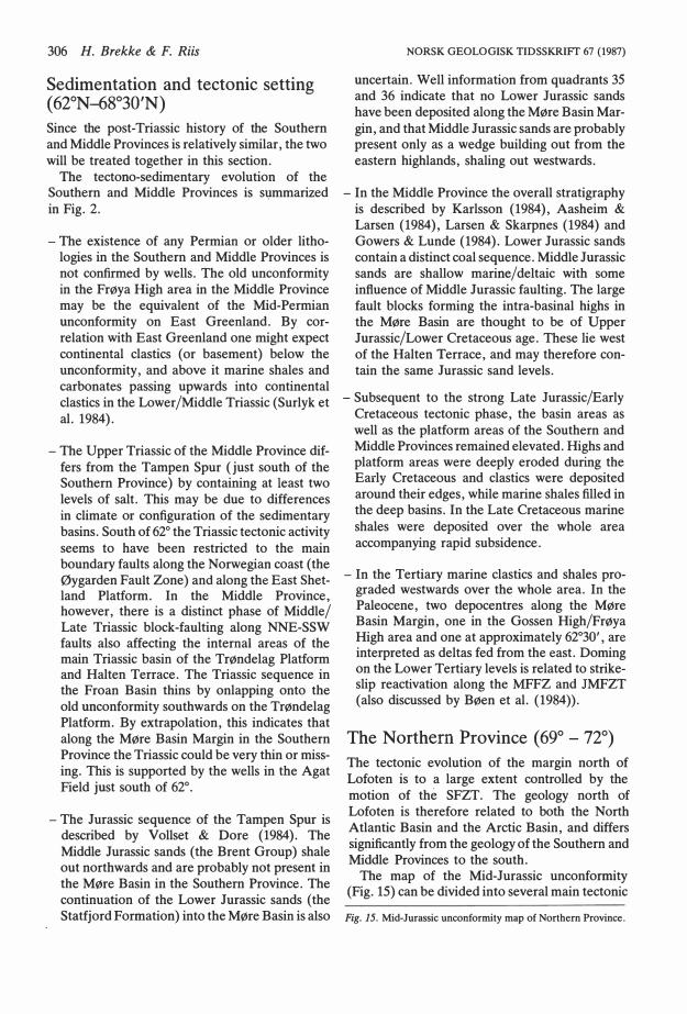
The Trøndelag Platform The Trøndelag Platform is defined as such on the base Cretaceous leve!, and is situated east of the Halten Terrace, Nordland Ridge and Vøring Basin (Fig. 1). The area has been the site of active rifting and major basin development in preCretaceous times. The history of the area may be envisaged from Fig. 10. The deepest reftector here represents a major unconformity of preMid-Triassic age. This unconformity represents a period of deep erosion. By correlation to East Greenland, the age of this unconformity is tentatively assigned to Mid-Permian (Surlyk et al. 1984).
Another phase of rifting and a subsequent erosional unconformity is observed in the Triassic. This phase was associated with NNE trending faults east of the Frøya High and in the Froan
Basin. By correlations with wells to the north, the unconformity coincides with a salt leve! dated to Late Camian (Jacobsen & van Veen 1984). This Middle to Late Triassic phase of rifting is more pronounced to the north and specially on the western part of the Halten Terrace. Above the salt, the sedimentation seems to have been continuous into the Jurassic.
The major p hase of rifting west of the platform area occurred in the Late Jurassic/Early Cretaceous. In this phase many of the Triassic faults were reactivated and the Frøya High was uplifted, forming a N-S trending anticlinal flexure of the sub-Cretaceous sequence (Fig. 10).
During the Early Cretaceous the Trøndelag Platform was a stable platform area, and was eroded down to a peneplain (Figs. l, 3a, b and 10). Seismic data provide evidence of deep Cretaceous canyons eroded into the edges of this peneplained platform around the Frøya High (Fig. 9). This indicates clastic input into the surrounding areas in the Early Cretaceous, and perhaps also in the early Late Cretaceous.
In Late Cretaceous times the whole platform started to tilt westwards and was transgressed. This is demonstrated by a sequence boundary in the thin Upper Cretaceous on the platform (Fig. lO). In the Halten Terrace this sequence boundary is dated by the NPD to intra-Turonian.
The eroded edge of the platform may be mapped as a distinct feature to the south and north of the Nordland Ridge (Figs. l and 3a, b). In the Nordland Ridge the peneplain and the distinct platform edge are uplifted and broken up by faulting (Fig. 13). These movements occurred in the Early Tertiary and perhaps as early as in the Late Cretaceous. East of the Nordland Ridge, the Helgeland Basin experienced its main period of subsidence in the Late Cretaceous subsequent
304 H. Brekke & F. Riis
w SHOT NUMBER E 1172 1100 1000 900 800 700 800 500 400 300 200 100 1
Fig. 11. Geoseismic section interpreted from seismic line HB-12-84. Key to symbols in Fig. 5, position in Fig. 4.
to the Turonian onset of tilting (Fig. 13). This implies that both the Nordland Ridge and the Helgeland Basin were parts of the Trøndelag Platform during the Lower Cretaceous, and were formed subsequent to the deep erosion and peneplaination of that platform.
In the area between the Helgeland and Vestfjorden Basins, the sub-Cretaceous rocks form an E-W trending anticline which was also peneplained in the Early Cretaceous.
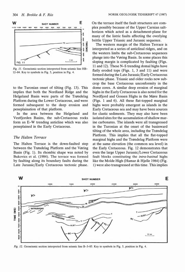
The Halten Terrace The Halten Terrace is the down-faulted step between the Trøndelag Platform and the V øring Basin (Fig. 1). Its rhombic shape was noted by Bukovics et al. (1984). The terrace was formed by faulting along its boundary faults during the Late Jurassic/Early Cretaceous tectonic phase.
NORSK GEOLOGISK TIDSSKRIFT 67 (1987)
On the terrace itself the fault structures are complex possibly because of the Upper Carnian salthorizon which acted as a detachment-plane for many of the listric faults affecting the overlying brittle Upper Triassic and Jurassic sequence.
The western margin of the Halten Terrace is interpreted as a series of anticlinal ridges, and on the western limbs the sub-Cretaceous sequences plunge into the V øring Basin. In some places this sloping margin is complicated by faulting (Figs. 11 and 12). These N-S trending domal highs have flatly eroded tops (Figs. l, 3 and 11) and were formed during the Late Jurassic/Early Cretaceous tectonic phase. Triassic and older rocks now subcrop the base Cretaceous unconformity in the dome cores. A similar deep erosion of marginal highs in the Earl y Cretaceous is also noted for the Nordfjord and Gossen Highs in the Møre Basin (Figs. l and 6). All these flat-topped marginal highs were probably emergent as islands in the Early Cretaceous sea and may have been sources for clastic sediments. They may also have been isolated sites for the accumulation of shallow marine carbonates. The islands were all transgressed in the Turonian at the onset of the basinward til ting of the whole area, including the Trøndelag Platform. This implies that all the flat-topped marginal highs and the Trøndelag Platform were at the same elevation (the common sea leve!) in the Early Cretaceous. Fig. 12 demonstrates that even the large Upper Jurassic/Lower Cretaceous fault blocks constituting the intra-basinal highs like the Molde High (Hamar & Hjelle 1984) (Fig. 1) were also transgressed at this time. This implies
w SHOT NUMBER E 1000 1500 2000 2500 3000 3500
o
e �--------------------
T T
Fig. 12. Geoseismic section interpreted from seismic line B-3-85. Key to symbols in Fig. 5, position in Fig. 4.

NORSK GEOLOGISK TIDSSKRIFT 67 (1987) TSGS Symposium 1986 305
NW SHOT NUMBER SE 1700 11500 1500 1400 1300 1200 1100 1000 900 800 700 600 500 400 300 200 100
� o o
o o -1
� i: m
� � �
o o
� o o
5km o o
g
Fig. 13. Geoseismic section interpreted from seismic line B-22-83. Key to symbols in Fig. 5, position in Fig. 4.
that the basin areas also experienced a transgression and a main period of subsidence in the Upper Cretaceous. In the Lower Cretaceous the sedimentation in the basin areas was an infilling of the pre-existing topography accompanied by some subsidence restricted to the local sub-basins between the fault controlled intra-basinal highs (Fig. 12).
The Vestfjorden Basin and Lofoten area Interpretation of new data indicate that the Vestfjorden Basin is essentially a Lower Cretaceous basin, and not a possible Palaeozoic basin as suggested by Bøen et al. (1984). The southern part of the basin is a tilted margin defining the
s
northern limb of the E-W trending anticline described above for the Trøndelag Platform. The overall geometry of the Vestfjorden Basin is that of a half graben defined by a boundary fault zone along the western margin (Figs. l and 3). The bounding faults were active in Late Jurassic/Early Cretaceous times and were probably reactivated in a separate phase in the Early Cretaceous. This separate Early Cretaceous phase and the Early Cretaceous subsidence make the Vestfjorden/ Lofoten area more like the Northern than the Middle Province in the Cretaceous. The change from Early Cretaceous basin subsidence in the north to Late Cretaceous basin subsidence in the south is very well illustrated by the northward thickening of the Lower Cretaceous outside Lofoten (Fig. 14).
N S H O T NUMBER
Ul ::E w ::E ...
o o
�
500 1000 1500 2000 2500
10 km
Fig. 14. Geoseismic section interpreted from seismic line B FB-74-3. Key to symbols in Fig. 5, position in Fig. 4.
3028 30 o
306 H. Brekke & F. Riis
Sedimentation and tectonic setting ( 62°N-68°30'N)
Since the post-Triassic history of the Southern and Middle Provinces is relative! y similar, the two will be treated together in this section.
The tectono-sedimentary evolution of the Southern and Middle Provinces is s\)mmarized in Fig. 2.
- The existence of any Permian or older lithologies in the Southern and Middle Provinces is not confirmed by wells. The old unconformity in the Frøya High area in the Middle Province may be the equivalent of the Mid-Permian unconformity on East Greenland. By correlation with East Greenland one might expect continental clastics (or basement) below the unconformity, and above it marine shales and carbonates passing upwards into continental clastics in the Lower/Middle Triassic (Surlyk et al. 1984).
- The Upper Triassic of the Middle Province differs from the Tampen Spur ( just south of the Southern Province) by containing at !east two levels of salt. This may be due to differences in climate or configuration of the sedimentary basins. South of 62° the Triassic tectonic activity seems to have been restricted to the main boundary faults along the Norwegian coast (the Øygarden Fault Zone) and along the East Shetland Platform. In the Middle Province, however, there is a distinct phase of Middle/ Late Triassic block-faulting along NNE-SSW faults also affecting the internal areas of the main Triassic basin of the Trøndelag Platform and Halten Terrace. The Triassic sequence in the Froan Basin thins by onlapping onto the old unconformity southwards on the Trøndelag Platform. By extrapolation, this indicates that along the Møre Basin Margin in the Southern Province the Triassic could be very thin or missing. This is supported by the wells in the Agat Field just south of 62°.
- The Jurassic sequence of the Tampen Spur is described by Vollset & Dore (1984). The Middle Jurassic sands (the Brent Group) shale out northwards and are pro babl y not present in the Møre Basin in the Southern Province. The continuation of the Lower Jurassic sands (the Statfjord Formation) into the Møre Basin is also
NORSK GEOLOGISK TIDSSKRIFf 67 (1987)
uncertain. Well information from quadrants 35 and 36 indicate that no Lower Jurassic sands have been deposited along the Møre Basin Margin, and that Middle Jurassic sands are probably present only as a wedge building out from the eastern highlands, shaling out westwards.
- In the Middle Province the overall stratigraphy is described by Karlsson (1984), Aasheim & Larsen (1984), Larsen & Skarpnes (1984) and Gowers & Lunde (1984). Lower Jurassic sands contain a distinct coal sequence. Middle Jurassic sands are shallow marine/deltaic with some inftuence of Middle Jurassic faulting. The large fault blocks forming the intra-basinal highs in the Møre Basin are thought to be of Upper Jurassic/Lower Cretaceous age. These Iie west of the Halten Terrace, and may therefore contain the same Jurassic sand levels.
- Subsequent to the strong Late Jurassic/Early Cretaceous tectonic phase, the basin areas as well as the platform areas of the Southern and Middle Provinces remained elevated. Highs and platform areas were deeply eroded during the Early Cretaceous and clastics were deposited around their edges, while marine shales filled in the deep basins. In the Late Cretaceous marine shales were deposited over the whole area accompanying rapid subsidence.
- In the Tertiary marine clastics and shales prograded westwards over the whole area. In the Paleocene, two depocentres along the Møre Basin Margin, one in the Gossen High/Frøya High area and one at approximately 62°30', are interpreted as deltas fed from the east. Doming on the Lower Tertiary levels is related to steikeslip reactivation along the MFFZ and JMFZT (also discussed by Bøen et al. (1984)).
The Northern Province (69°- 72°)
The tectonic evolution of the margin north of Lofoten is to a large extent controlled by the motion of the SFZT. The geology north of Lofoten is therefore related to both the North Atlantic Basin and the Arctic Basin, and differs significantly from the geology of the Southern and Middle Provinces to the south.
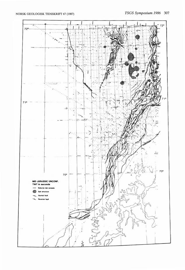
The map of the Mid-Jurassic unconformity (Fig. 15) can be divided into several main tectonic
Fig. 15. Mid-Jurassic unconformity map of Northern Province.
NORSK GEOLOGISK TIDSSKRIFT 67 (1987)
,.
J. . .. . l '· ---
71° -
MID JURASSIC UNCONF. TWT In aeconda
&mc:rop "*l ..u...ac • Salt •truetw• .._.., Normal fawt """""- Reveru fautt
' ·
70° ·-·
TSGS Symposium 1986 307
71°
·· 7o•
l '
308 H. Brekke & F. Riis
elements parallel to the Norwegian mainland, and further subdivided intohighs, sub-basins and terraces (Fig. 1).
The main trends are the following, from east to west:
- The shallow platform along the Norwegian mainland (referred to as the Troms-Finnmark. Platform by Gabrielsen et al. (1984), and termed the Troms Platform in this paper, as it seems useful to subdivide the Troms-Finnmark Platform into two parts). The Middle Jurassic subcrops or is close to subcrop.
- The block-faulted terrace with N-S and NESW trending faults forming rotated fault blocks. The Middle Jurassic here is situated between l and 3 seconds TW T. The faults were active in the Late Jurassic and in the Cretaceous. The northem part of this faulted zone is termed the Ringvassøy-Loppa Fault Complex by Gabrielsen et al. (1984), and the southem part is classified by them as belonging to the TromsFinnmark Fault Complex.
- The deep basin trend where the Jurassic is generally below 5 seconds. The Lower Cretaceous is very thick ( > 2 sec TWT) in both the Harstad and Tromsø basins.
- The outer high which is encountered north of
MO UPPER TERTIARY UNCONF.
- TP TOP PALEOCENE
- IP INTRA PALEOCENE
75 CAMP CAMPANIAN UNCONF.
- ALB ? ALBIAN MARKER
- APT APTIAN MARKER
HAUT HAUTERIVIAN
- TJ UPPER JURASSIC UNCONF.
1 70 MJ MID JURASSIC UNCONF.
230 TPE TOP PERMIAN
BASEMENT
Fig. 16. Key and proposed ages of seismic horizons in geoseismic sections from the Northern Province.
NORSK GEOLOGISK TIDSSKRIFT 67 (1987)
71°, and is termed the Senja Ridge. This ridge. is characterized by a strong positive gravity anomaly and a complex structuring in the Cretaceous and Tertiary.
- The westemmost deep basin which seems to be filled with Cretaceous sediments of thicknesses comparable to the Harstad and Tromsø Basins. However, its Tertiary fill is mainly younger, and this basin is thought to represent the continuation to the south of the Bjørnøy Basin as defined by Gabrielsen et al. (1984). It is strongly eroded in the Late Tertiary, and overlain by a thick Pliocene-Pleistocene wedge.
The Jurassic cannot be mapped in the deep basin areas, except in the northemmost part of the Tromsø Basin, where it is found at 7 to 7.5 sec TWT. In the Senja Ridge, we can only map a deep reflector el ose to the base Cretaceous.
The Northem Province may be subdivided into three segments according to tectonic style; this subdivision is illustrated by three profiles (Fig. 17, Fig. 18, Fig. 19).
Southern segment ( 6<.? -70"25 ')
This segment is characterized by a gently faulted, but steeply tilted Jurassic terrace, a very narrow platform and prominent, extensional faults of Cretaceous age forming large, strongly rotated fault blocks and rollovers in the Harstad Basin. These listric faults show an E-W trend to the south and a NNE-SSW trend to the north (Fig. 15). The profile 1630 (Fig. 17) cuts across the EW trend and continues into Andfjord, where several E-W trending fault blocks cause the Jurassic to Cretaceous sequence to subcrop.
The E-W trending Andfjord segment differs from the NNE trending part in having a JurassicTriassic terrace structured by listric faults sliding on the Permian. The NNE trending segment of Senja to Ringvassøy is characterized by a tilted Jurassic sequence with minor faulting.
The timing of the main fault activity is complicated due to seismic quality and lack of geological information from the Upper Cretaceous and Tertiary sequence. However, in Fig. 17 it seems that the main fault activity ceased at the Jurassic/Cretaceous boundary in the southern old terrace, and in the Late Cretaceous in the northem younger terrace. It will therefore be correlated with the main tectonic phases farther north.
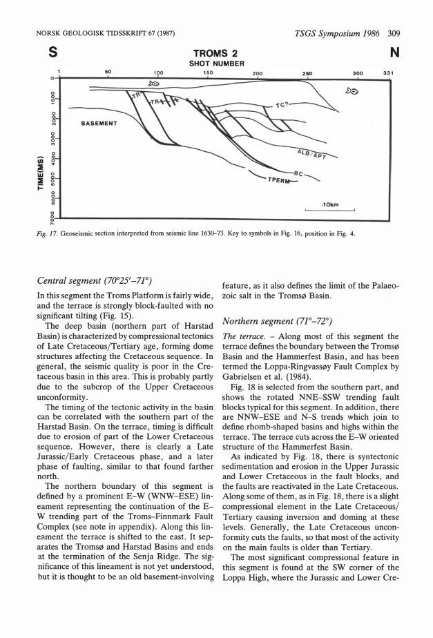
NORSK GEOLOGISK TIDSSKRIFT 67 (1987) TSGS Symposium 1986 309
s
50 100
TROMS 2 SHOT NUMBER
150
N
300 331 o
o o �
o o o "' o
en o o :l ...
w o :l o o j:: .,
o o o "' .10km o o o ....
Fig. 17. Geoseismic section interpreted from seismic line 1630--73. Key to symbols in Fig. 16, position in Fig. 4.
Central segment (70025'-7]0)
In this segment the Troms Platform is fair ly wide, and the terrace is strongly block-faulted with no significant tilting (Fig. 15).
The deep basin (northern part of Harstad Basin) is characterized by compressional tectonics of Late Cretaceous/Tertiary age, forming dome structures affecting the Cretaceous sequence. In .general, the seismic quality is poor in the Cretaceous basin in this area. This is probably partly due to the subcrop of the Upper Cretaceous unconformity.
The timing of the tectonic activity in the basin can be correlated with the southern part of the Harstad Basin. On the terrace, timing is difficult due to erosion of part of the Lower Cretaceous sequence. However, there is clearly a Late Jurassic/Early Cretaceous phase, and a later phase of faulting, similar to that found farther north.
The northern boundary of this segment is defined by a prominent E-W (WNW-ESE) lineament representing the continuation of the EW trending part of the Troms-Finnmark Fault Complex (see note in appendix). Along this lin
. eament the terrace is shifted to the east. It sep-arates the Tromsø and Harstad Basins and ends at the termination of the Senja Ridge. The significance of this lineament is not yet understood, but it is thought to be an old basement-involving
feature, as it also defines the limit of the Palaeozoic salt in the Tromsø Basin.
Northern segment (7J0-72°)
The terrace. - Along most of this segment the terrace defines the boundary between the Tromsø Basin and the Hammerfest Basin, and has been termed the Loppa-Ringvassøy Fault Complex by Gabrielsen et al. (1984).
Fig. 18 is selected from the southern part, and shows the rotated NNE-SSW trending fault blocks typical for this segment. In addition, there are NNW-ESE and N-S trends which join to define rhomb-shaped basins and highs within the terrace. The terrace cuts across the E-W oriented structure of the Hammerfest Basin.
As indicated by Fig. 18, there is syntectonic sedimentation and erosion in the Upper Jurassic and Lower Cretaceous in the fault blocks, and the faults are reactivated in the Late Cretaceous. Along some of them, as in Fig. 18, there is a slight compressional element in the Late Cretaceous/ Tertiary causing inversion and doming at these levels. Generally, the Late Cretaceous unconformity cuts the faults, so that most of the activity on the main faults is older than Tertiary.
The most significant compressional feature in this segment is found at the SW corner of the Loppa High, where the Jurassic and Lower Cre-
310 H. Brekke & F. Riis
NW 100 200
o
'� (i) o o :lE o
"' w :lE i=
TROMS 3 SHOT NUMBER
300 400 500 600
NORSK GEOLOGISK TIDSSKRIFT 67 (1987)
SE 700 776
g�--------------------------------------------� Ill
Fig. 18. Geoseismic section interpreted from seismic line T+83. Key to symbols in Fig. 16, position in Fig. 4.
taceous form an E-W tren ding dome structure (Riis et al. 1985).
The Cretaceous tectonic activity seems to have been restricted to the Ringvassøy-Loppa Fault Zone and the area to the west, and does not extend very far into the Hammerfest Basin as a major event.
Tromsø Basin. - The Tromsø Basin is one of the deepest sedimentary basins on the Norwegian shelf. Below the Jurassic, which is situated at below 7 sec TWT , the re must be a thick Palaeozoic sequence, as indicated by the large salt structures in the basin. Also, the Tromsø Basin and the southernmost part of the Bjørnøy Basin are notable for their Upper Cretaceous sections. Here, these sequences are fair ly thick, as opposed to other areas in the Barents Sea, which contain condensed Upper Cretaceous sequences where they can be observed. Structurally, the Tromsø Basin is a typical salt basin, and most of the tectonic activity is linked to the salt movement. Most of the salt diapirs have reached the surface.
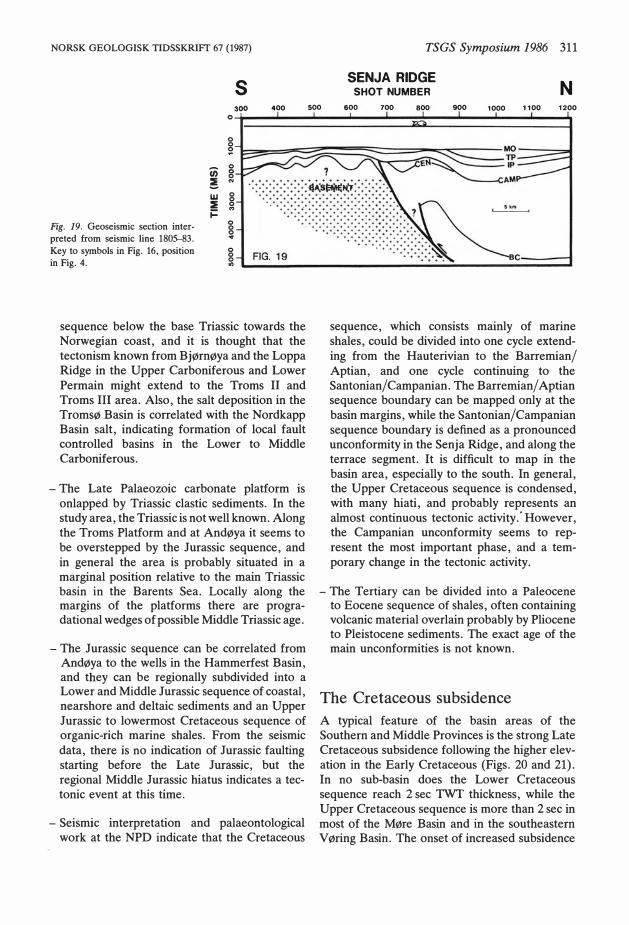
Senja Ridge. - The Senja Ridge is interpreted as a basement high. The top of the basement is difficult to define seismically due to strong tectonic movements and steeply dipping layers. The base Cretaceous refiector mapped on the southern part of the ridge is thought to be close to the top of the basement, but there may be a thin Upper Palaeozoic, Triassic and Jurassic sequence present.
The northern part of the Senja Ridge is separated from the southern part by a WNW-ESE trending fault. This fault probably originated as a normal fault, but has been reversed with a strong compressional component, causing asymmetric folds to develop in the Cretaceous and Tertiary sequences. The compression has taken
place in at !east two phases, terminating in the Upper Cretaceous (Campanian phase) and later than Paleocene (? Oligocene phase) (Fig. 19). This style of deformation, with strong reactivation of basement faults, seems to be typical for the Senja Ridge. The thick shale sequences seem to fiow during the deformation, forming very complicated fold structures.
The southern termination of the Senja Ridge seems to be linked to the junction with the Senja Fracture Zone, but in this area the seismics do not give sufficient resolution.
The Bjørnøy Basin, southern part. - This basin area is poorly known. It is characterized by a thick Cretaceous and Tertiary sequence, and the Upper Cretaceous seems to be well developed. There is a consistent outer high at the Cretaceous leve! as indicated in the map (Fig. 15), and which defines the limit to the thick Tertiary basin linked to the opening of the Greenland Sea. This high has a trend similar to the SFZT. In the Oligocene or· later, the basin area was deeply eroded anØ covered by a very thick Pliocene/Pleistocene wedge. The structuring is complex, but linked to normal faulting. In addition, one can observe a few large domal structures which seem to be caused by Tertiary intrusions possibly combined with compression.
Sedimentation and tectonic setting
The stratigraphy (Fig. 2) is divided into the main sedimentary cycles, as observed from the wells in the Hammerfest Basin, and the outcrop data.
- The Late Palaeozoic cycle is known only from the highs. The basal beds at Andøya are interpreted by Dall and (1981) to be of Carboniferous age. Seismically, there is a thinning of the
NORSK GEOLOGISK TIDSSKRIFf 67 (1987)
Fig. 19. Geoseismic section interpreted from seismic line 1805-83. Key to symbols in Fig. 16, position in Fig. 4.
li) ! w :E j:
s
o o S! o o o N
o o o ..,
o o o ... o o o .,
400
sequence below the base Triassic towards the Norwegian coast, and it is thought that the tectonism known from Bjørnøya and the Loppa Ridge in the Upper Carboniferous and Lower Permain might extend to the Troms Il and Troms Ill area. Also, the salt deposition in the Tromsø Basin is correlated with the Nordkapp Basin salt, indicating formation of local fault controlled basins in the Lower to Middle Carboniferous.
- The Late Palaeozoic carbonate platform is onlapped by Triassic clastic sediments. In the study area, the Triassic is not well known. Along the Troms Platform and at Andøya it seems to be overstepped by the Jurassic sequence, and in general the area is probably situated in a marginal position relative to the main Triassic basin in the Barents Sea. Locally along the margins of the platforms there are progradational wedges of possible Middle Triassic age.
- The Jurassic sequence can be correlated from Andøya to the wells in the Hammerfest Basin, and they can be regionally subdivided into a Lower and Middle Jurassic sequence of coastal, nearshore and deltaic sediments and an Upper Jurassic to lowermost Cretaceous sequence of organic-rich marine shales. From the seismic data, there is no indication of Jurassic faulting starting before the Late Jurassic, but the regional Middle Jurassic hiatus indicates a tectonic event at this time.
- Seismic interpretation and palaeontological work at the NPD indicate that the Cretaceous
500
TSGS Symposium 1986 311
SENJA RIDGE SHOT NUMBER
600 700 800 900
N 1000 1100 1200
sequence, which consists mainly of marine shales, could be divided into one cycle extending from the Hauterivian to the Barremian/ Aptian, and o ne cycle continuing to the Santonian/Campanian. The Barremian/ Aptian sequence boundary can be mapped only at the basin margins, while the Santonian/Campanian sequence boundary is defined as a pronounced unconformity in the Senja Ridge, and along the terrace segment. It is difficult to map in the basin area, especially to the south. In general, the Upper Cretaceous sequence is condensed, with many hiati, and probably represents an alm ost continuous tectonic activity .' However, the Campanian unconformity seems to represent the most important phase, and a temporary change in the tectonic activity.
- The Tertiary can be divided into a Paleocene to Eocene sequence of shales, often containing volcanic material overlain probably by Pliocene to Pleistocene sediments. The exact age of the main unconformities is not known.
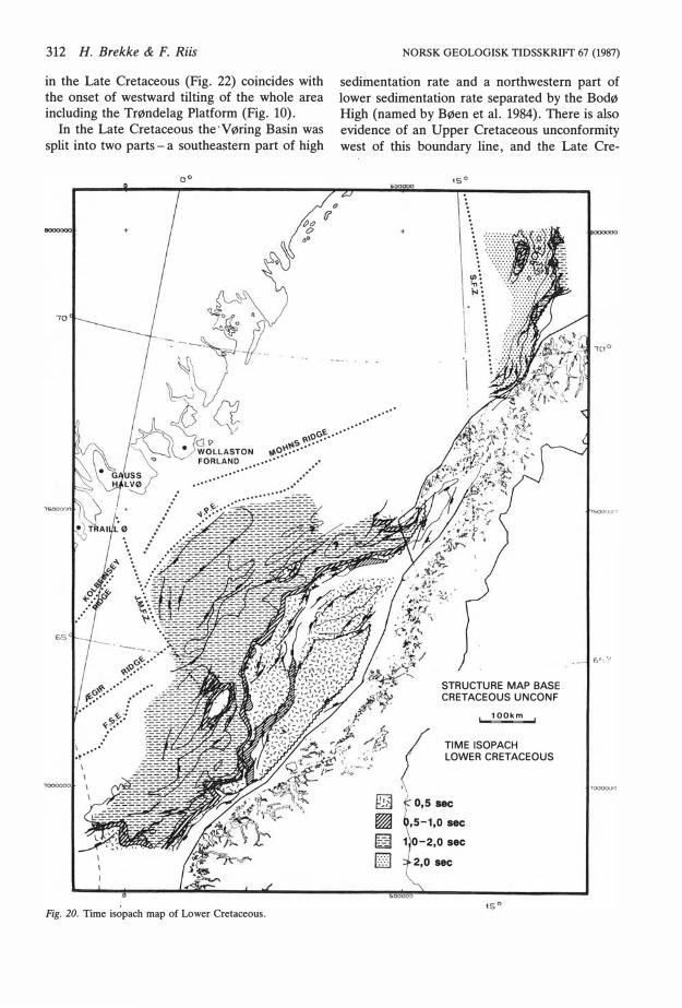
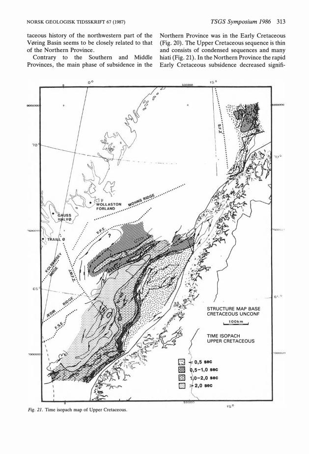
The Cretaceous subsidence
A typical feature of the basin areas of the Southem and Middle Provinces is the strong Late Cretaceous subsidence following the higher elevation in the Early Cretaceous (Figs. 20 and 21). In no sub-basin does the Lower Cretaceous sequence reach 2 sec TWT thickness, while the Upper Cretaceous sequence is more than 2 sec in most of the Møre Basin and in the southeastem V øring Basin. The onset of increased subsidence
312 H. Brekke & F. Riis
in the Late Cretaceous (Fig. 22) coincides with the onset of westward tilting of the whole area including the Trøndelag Platform (Fig. 10).
In the Late Cretaceous the·Vøring Basin was split in to two parts - a southeastern part of high
+
70
NORSK GEOLOGISK TIDSSKRIFT 67 (1987)
sedimentation rate and a northwestern part of lower sedimentation rate separated by the Bodø High (named by Bøen et al. 1984). There is also evidence of an Upper Cretaceous unconformity west of this boundary line, and the Late Cre-
.... ··
s�,o��············
"'0�� .. ··· ········
···· ······
Fig. 20. Time isopach map of Lower Cretaceous.
STRUCTURE MAP BASE CRETACEOUS UNCONF
100km
TIME ISOPACH LOWER CRETACEOUS
2,0 sec
6r.,'-'
NORSK GEOLOGISK TIDSSKRIFT 67 (1987)
taceous history of the northwestern part of the Vøring Basin seerns to be closely related to that of the Northern Province.
Contrary to the Southern and Middle Provinces, the rnain phase of subsidence in the
Fig. 21. Time isopach map of Upper Cretaceous.
TSGS Symposium 1986 313
Northern Province was in the Early Cretaceous (Fig. 20). The Upper Cretaceous sequence is thin and consists of condensed sequences and rnany hiati (Fig. 21). In the Northern Province the rapid Early Cretaceous subsidence decreased signifi-
STRUCTURE MAP BASE CRETACEOUS UNCONF
100km
TIME ISOPACH UPPER CRETACEOUS
sec
314 H. Brekke & F. Riis
AGE IN Ma -zco -150
:1 l
TRØNDELAG PLATFORM
-zco -ISO -100 -sa o
�!��:� :i " ! .. :r -200 -ISO -100 -50 ... lb
o
Q -E BA&IN
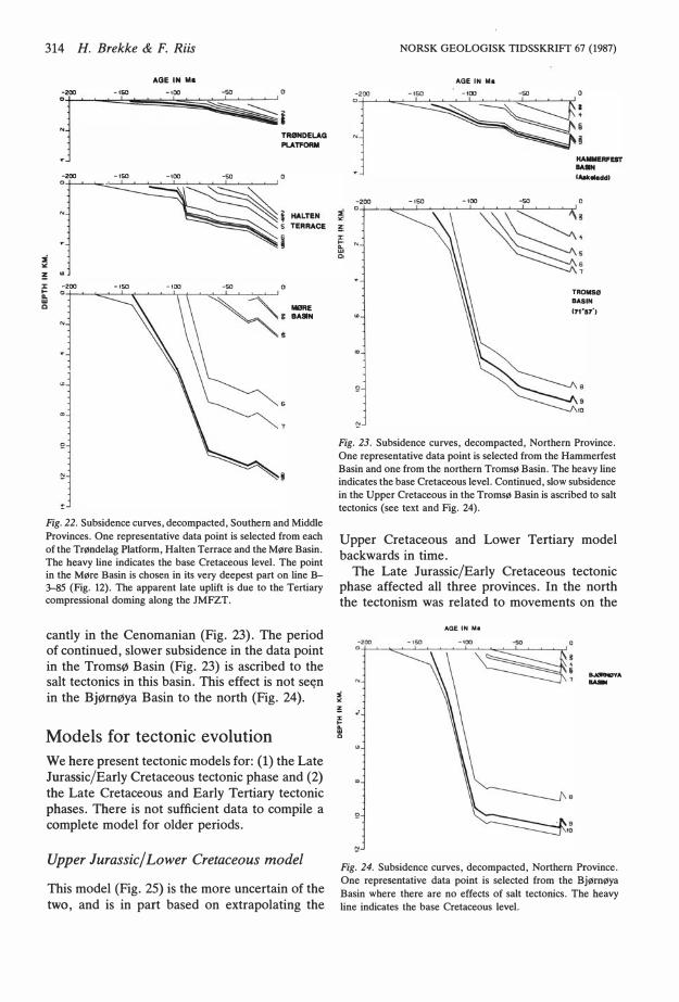
Fig. 22. Subsidence curves, decompacted, Southem and Middle Provinces. One representative data point is selected from each of the Trøndelag Platform, Halten Terrace and the Møre Basin. The heavy line indicates the base Cretaceous leve!. The point in the Møre Basin is chosen in its very deepest part on line B�5 (Fig. 12) . The apparent late uplift is due to the Tertiary compressional doming along the JMFZT.
cantly in the Cenomanian (Fig. 23). The period of continued, slower subsidence in the data point in the Tromsø Basin (Fig. 23) is ascribed to the salt tectonics in this basin. This effect is not settn in the Bjørnøya Basin to the north (Fig. 24).
Models for tectonic evolution We here present tectonic models for: (l) the Late Jurassic/Early Cretaceous tectonic phase and (2) the Late Cretaceous and Early Tertiary tectonic phases. There is not sufficient data to compile a complete model for older periods.
Upper Jurassic/Lower Cretaceous model
This model (Fig. 25) is the more uncertain of the two, and is in part based on extrapolating the
NORSK GEOLOGISK TIDSSKRIFr 67 (1987)
AGE IN Mo
I�L� IAokoladdl
·ISO -100 -50
TROMSØ BAS IN (71·17·)
10
Fig. 23. Subsidence curves, decompacted, Northern Province. One representative data point is selected from the Hammerfest Basin and one from the northern Tromsø Basin. The heavy line indicates the base Cretaceous leve!. Continued, slow subsidence in the Upper Cretaceous in the Tromsø Basin is ascribed to salt tectonics (see text and Fig. 24).
Upper Cretaceous and Lower Tertiary model backwards in time.
The Late Jurassic/Early Cretaceous tectonic phase affected all three provinces. In the north the tectonism was related to movements on the
AGE IN Ma
.__,.A -
Fig. 24. Subsidence curves, decompacted, Northern Province. One representative data point is selected from the Bjørnøya Basin where there are no effects of salt tectonics. The heavy line indicates the base Cretaceous leve!.
NORSK GEOLOGISK TIDSSKRIFf 67 (1987)
500000
TECTONIC M �
Upper Jurassic l �er Cretaceous o•
<o
....
"'o��······
�o"��····
······�····
·········
.. ·······
·······
... ·····
············
TSGS Symposium 1986 315
�\'v 000000
___ ,65°
STRUCTURE MAP BASE CRETACEOUS UNCONF
100km
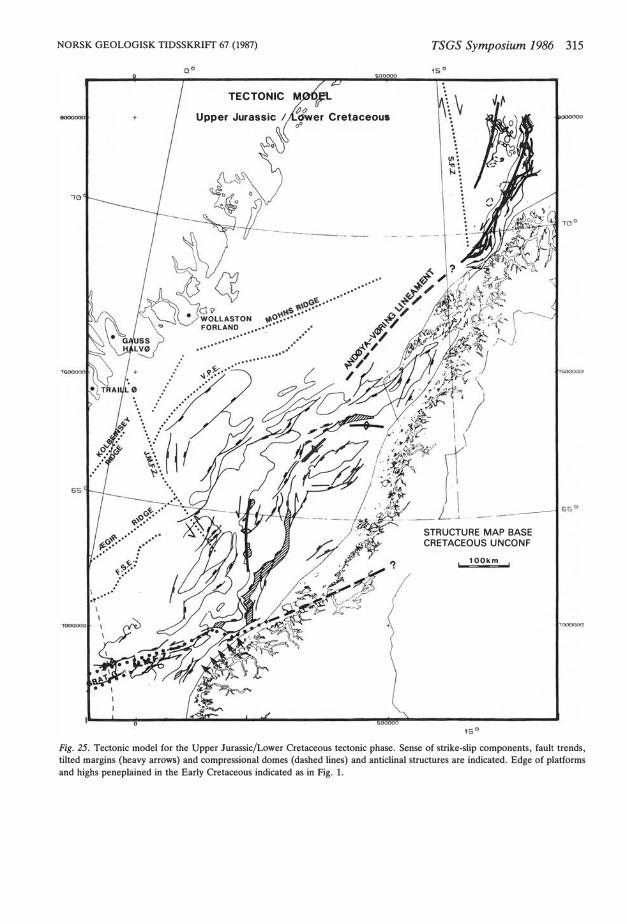
Fig. 25. Tectonic model for the Upper Jurassic/Lower Cretaceous tectonic phase. Sense of strike·slip components, fault trends, tilted margins (heavy arrows) and compressional dom es ( dashed lines) and anticlinal structures are indicated. Edge of platforms and highs peneplained in the Early Cretaceous indicated as in Fig. l.
316 H. Brekke & F. Riis
old lineaments; the SFZT and the NNE trending zones along the Senja Ridge and Troms Terrace (Fig. 25). The sense of movement along these lineaments is not well established for this period. Tectonism was dominated by normal faulting, but a dome in the SW corner of the Loppa High indicates that a NW-SE dextral/NE-sW sinistral shear component on these old lineaments was established in the Lower Cretaceous (Riis et al. 1985). This system continued in the same sense in the Late Cretaceous and Early Tertiary phases. We thus suggest that the SFZT had a dextral component in the Upper Jurassic/Lower Cretaceous phase, too.
To the south, the sinistral component on the complex rollover of the Gossen High and compressional folds in the Nordfjord High area indicate that the MFFZ had a sinistral component in the Upper Jurassic/Lower Cretaceous phase. Such a sense of movement away from the JMFZT also explains formation of the deep parts of the Møre Bas in along the southern side of the JMFZT (Figs. l, 3 and 12).
The JMFZT seems to have had a sinistral component during this tectonic phase, and hence cannot be explained as a simple conjugate system to the MFFZ. The postulation of this sense of movement is based on the following evidence:
- The rhombic shape of the Halten Terrace and its associated NNE to NE trending extensional faults indicate that the Halten Terrace is a pullapart structure in a sinistral system.
- The N-S trending compressional domes along the western margin of the Halten Terrace.
- The sinistral offset of the basement at the southern termination of the Trøndelag Platform.
A relative sinistral displacement on the JMFZT seems also to be necessary to take up the difference in extension between the narrow and deep Møre Basin and the shallower, but much wider extension zone of the combined V øring Bas in and Halten Terrace.
To the north on the Trøndelag Platform, the extensional faults turn to a more northerly strike (east of the Helgeland Basin), and the compressional structures turn to an E-W strike (anticlinal ridge south of Vestfjorden). In our model this is explained by increasing influence from the
NORSK GEOLOGISK TIDSSKRIFT 67 (1987)
SFZT system to the north, through the NNE trending, sinistral conjugate branch along the Troms Terrace extrapolated SSW-wards west of Lofoten. We sugget the name 'Andøya-Vøring Lineament' (AVL) for this structural trend (Figs. 25 and 26) (see appendix for definition).
In summary, the suggested sense of movements on the SFZT and the MFFZ would allow Greenland to move NW-wards away from Norway.
On the Barents Shelf, no strong extension should be expected in this phase, except perhaps in the southwestern part where the SFZT joins the fault zone along the Troms Terrace.
Upper Cretaceous and Lower Tertiary mo del
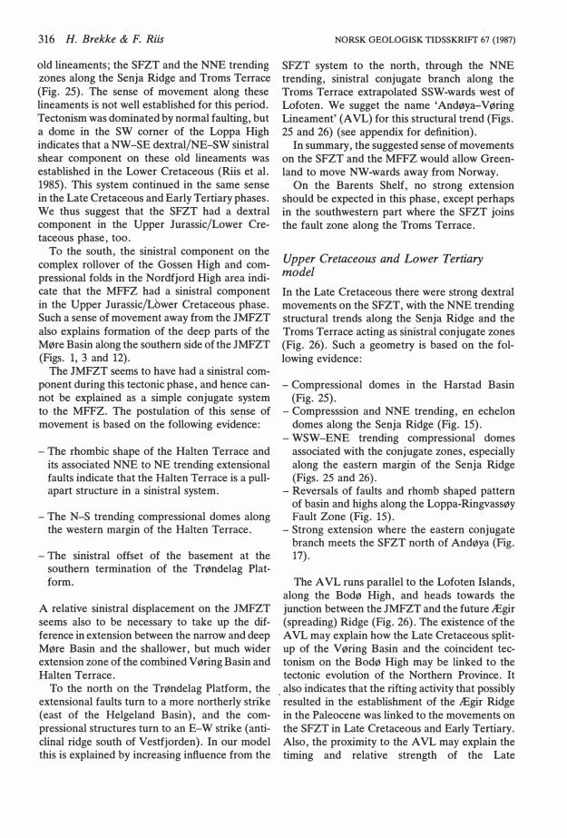
In the Late Cretaceous there were strong dextral movements on the SFZT, with the NNE trending structural trends along the Senja Ridge and the Troms Terrace acting as sinistral conjugate zones (Fig. 26). Such a geometry is based on the following evidence:
- Compressional domes in the Harstad Basin (Fig. 25).
- Compresssion and NNE trending, en echelon domes along the Senja Ridge (Fig. 15).
- WSW-ENE trending compressional domes associated with the conjugate zones, especially along the eastern margin of the Senja Ridge (Figs. 25 and 26).
- Reversals of faults and rhomb shaped pattern of basin and highs along the Loppa-Ringvassøy Fault Zone (Fig. 15).
- Strong extension where the eastern conjugate branch meets the SFZT north of Andøya (Fig. 17).
The AVL runs parallel to the Lofoten Islands, along the Bodø High, and heads towards the junction between the JMFZT and the future Ægir (spreading) Ridge (Fig. 26). The existence of the AVL may explain how the Late Cretaceous splitup of the Vøring Basin and the coincident tectonism on the Bodø High may be linked to the tectonic evolution of the Northern Province. It
. also indicates that the rifting activity that possibly resulted in the establishment of the Ægir Ridge in the Paleocene was linked to the movements on the SFZT in Late Cretaceous and Early Tertiary. Also, the proximity to the AVL may explain the timing and relative strength of the Late
NORSK GEOLOGISK TIDSSKRIFT 67 (1987)
0000000
7()
65
'1>00000
TECTONIC �BEL Upper Cretaceou fJ,.ower Paleoce ..
o•
,oc.� .. ········
�" �····
�o� •• •
......
·
··
... � - -
..
··
············
·
,:_ ...
..
··
...
TSGS Symposium 1986 317
STRUCTURE MAP BASE CRETACEOUS UNCONF
100km
500000
Fig. 26. Tectonic model for the Upper Cretaceous and Lower Tertiary tectonic phases. Structural elements indicated as in Fig. 25.
318 H. Brekke & F. Riis NORSK GEOLOGISK TIDSSKRIFT 67 (1987)
,,_
., .
. l -··;:'l
-,
BASE TER'T'IAAY ...........
-- ...:MOUTI.M: ······ UITUM a.-t OF EAI'Il. Y TnmAIIY BASAlT
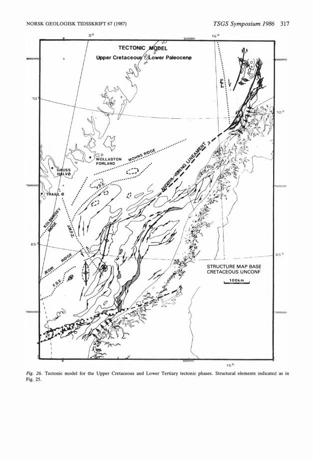
Fig. 27. Base Tertiary map, Møre and V øring Basins (revised from Bøen et al. 1984). The compressional domes are also indicated in Fig. 26. Note that to the west of the Faeroe-Shetland and V øring Escarpments, the contours are on the top-basalt leve!.
NORSK GEOLOGISK TIDSSKRIFf 67 (1987)
Cretaceous/Early Tertiary uplift and faulting of the Nordland Ridge.
On the JMFZT, east of the future Ægir Ridge, the N-S striking Lower Tertiary domes indicate a sinistral sense of movements (Figs. 26 and 27). This fits with a slight conjugate dextral movement on the MFFZ giving fault reversals, as seen in Fig. 7. The doming in the Tertiary along the JMFZT is seen as an uplift in Fig. 22. The sense of movement on the JMFZT west of the Ægir Ridge is not known.
The above evidence and interpretation suggest to the authors that in the Late Cretaceous and Early Tertiary the main tectonism took place in the north and to the west of the AVL. The area to the south and east experienced only minor adjustments linked to the main lineaments.
Correlation with North Atlantic plate tectonics The Jurassic to present tectonic evolution of the Norwegian shelf may be correlated to plate tectonic movements.
The Late Jurassic/Early Cretaceous tectonic phase affected the whole shelf, and in our model we see the SFZT, MFFZ and the JMFZT as main structural province boundaries during this phase. Since the old lineament of the Tornquist Zone as mapped by Pegrum (1984) links with the MFFZ south of Shetland, it seems appropriate to consider this zone in context with the other lineaments. Assuming a conjugate system, the sense of the strike-slip components on the lineaments postulated by us does not fit with the sinistral component on the Tornquist Zone as indicated by Pegrum (op. cit.). In a conjugate system this sense on the Tornquist Zone would demand a dextral component on the MFFZ and a sinistral component (as in our model) on the JMFZT. This would lead to compression in the structural corner of the Gossen High area, and not to high extension as our interpretation shows.
These discrepancies cause us to disregard any mega-scale, controlling strike-slip movements during this phase. The tectonic pattern may be regarded as a simple, overall E-W extension between Norway and Greenland, in which the old lineaments of weakness acted as large-scale transfer faults. The sinistral component on the Tornquist Zone may then be explained as a necessity to accommodate the difference in extension
TSGS Symposium 1986 319
between the Viking and Central Grabens - a parallel to our model for the relationship between the JMFZT and the extension in the Møre and Vøring Basins.
In Late Cretaceous and Early Tertiary times there was dextral movement on the SFZT. This sense fits with the onset of relative anti-clockwise rotation of Greenland due to the onset of opening of the Labrador Sea. These rotational movements put a definite element of strike-slip control on the tectonics of this phase. However, according to our model the shallow areas of the Norwegian Shelf east of the AVL were relatively protected from these movements except for some reactivation on major faults.
The Cretaceous subsidence in the deep basin areas cannot easily be explained by pure Jurassic extension and cooling alone. The authors have compared the subsidence curves with typical exponential cooling curves (McKenzie 1978). Even when the sediment load is removed with full isostatic compensation in each point, it is found that:
- The amount of subsidence is too high to be accounted for by cooling only.
- The shape of the subsidence curves do not fit, as the Late Cretaceous subsidence is too late to be explained by a cooling model.
- The timing of subsidence is different between the north and south, as the whole of the main subsidence period in the north ended as early as the Campanian.
Furthermore, the large amount of Cretaceous subsidence is considered to be too high to be explainable by the world-wide transgression, so we have tried to look at alternative explanations. We suggest that off Mid-Norway the Late Cretaceous subsidence could be linked to the rifting in the central part of the Atlantic (Continuation of the fracture zone along the AVL). A strong rifting here, prior to the opening of the Atlantic, could possibly cause a downwarping of the crust towards the Norwegian mainland.
For the northern areas, it can be speculated that the Barremian/ Aptian opening of the Arctic Canadian Ocean influenced the SFZT and western margin of the Barents Sea causing additional subsidence in the Early Cretaceous.
Acknowledgements. - We thank Statoil for permission to use some of their data.
320 H. Brekke & F. Riis
Appendix Nomenclature/Definitions
Troms Platform
Named after Troms county.
References: Together with the Finnmark Platform referred to as Troms-Finnmark Platform by Gabrielsen et al. (1984), but this term has not be en strictly defined.
Position: 69"20'-71°N, 16°30'-20°E.
Description: The Troms Platform is a fairly narrow platform situated between the subcropping basement along the Norwegian coast and the Troms-Finnmark Fault Complex. It seems to consist mainly of rocks of Permian, Triassic and Jurassic ages, while younger sediments are eroded to a large extent. Its eastem limit to the Finnmark Platform is defined by the
· continuation of the basement high extending from Senja to Ringvassøy and further north.
Correspondingly, the Finnmark Platform is situated between 200 and 25•E, between the subcropping basement and the Troms-Finnmark Fault Complex. It seems to be built up of rocks from Carboniferous to Jurassic ages, while younger rocks are eroded to a large extent. The platform seems to contain sub-basins of Carboniferous or older age. Its eastern limit is difficult to define, but is chosen to be where the throw of the Troms-Finnmark Fault Complex is very small.
As a common name is suggested the Troms-Finnmark Platform and to also include the eastward continuation of the platform area between 200 and 25°E.
Age: The area has been a platform element with its present configuration since Late Jurassic/Early Cretaceous times.
Magnus-Fosen Fault Zone
Named after the Magnus Basin and the Fosen Peninsula.
References: None.
Position: 61°45'-63°45'N, 00040'-100E.
Description: The Magnus-Fosen Fault Zone runs with an ENE trend through the southeastern part of the Møre Basin from the Nordfjord High to the Gossen High, where it cuts in to the Møre Basin Margin. The MFFZ is situated to the west of the MøreTrøndelag Fault Zone (MTFZ), which delimits the Møre Basin to the east (Gabrielsen et al. 1984). The MFFZ has a more easterly trend than the MTFZ and hence intersects the MTFZ in the Smøla-Fosen area.
The MFFZ between the Nordfjord High and the Gossen High is defined by a zone of several fault controlled highs and depressions that separate the shallower southeastern part of the Møre Basin from the overall deeper main parts of the basin to the northwest. The Magnus Basin is situated within the MFFZ.
Age: Mapping based on seismics and well data in the area around the Magnus Basin, shows that MFFZ was formed in a major phase of fault activity, probably with a sinistral component, in Late Jurassic/Early Cretaceous times. The fault ·
NORSK GEOLOGISK TIDSSKRIFT 67 (1987)
zone experienced a less significant phase of reactivation in Early Tertiary times.
Møre Basin Margin
Named after Møre County.
References: The structure was described as a part of the MøreTrøndelag Fault Zone by Gabrielsen et al. (1984), but was not designated a separate name.
Position: 61.50'-63•N, 3"30'-6.40'. The structure is situated within the Møre-Trøndelag Fault Zone (MTFZ), as defined by Gabrielsen et al. (1984).
Description: The Møre Basin Margin constitutes the eastern ftank of the Møre Basin between the Sogn Graben and the Trøndelag Platform. The Møre Basin Margin is defined by a narrow, westward tilted sub-Cretaceous sequence between 0.5 and 5.0 seconds TWT, onlapped by Cretaceous sediments. There are no prominent down to the basin faults in this part of the MTFZ, except in northernmost part (62.55'-63.N) where the Møre Basin Margin is involved in the Magnus-Fosen Fault Zone. Hence, the Møre Basin Margin is essentially a downwarp and not a fault margin. The boundary between the Møre Basin Margin and the Møre Basin is set at 5 sec TWT.
Age: Well information from quadrants 35 and 36 indicate that the faulting is of Middle to Late Jurassic age. The formation of the Møre Basin Margin through downwarping and tilting must have started in the lates! Jurassic or earliest Cretaceous as most of the Cretaceous sequence is seen to onlap the tilted margin. A few down to the basin faults (downthrowing to the west) probably initiated subsequent to the tilting, as they do not appear to be oversteepened by later rotation.
Andøya-V øring Lineament
Named after the island of Andøya and the V øring Basin.
References: None.
Position: 65.30'-69.15'N, 2°-15°E
Description: The Andøya-V øring Lineament (AVL) is defined by a series of NE trending faults and fault controlled depressions and ridges in the V øring Basin including the Røst Sub-basin, the Træn Sub-basin, the Bodø High and the southwestern faulted margin of the Lofoten Islands. Data outside Lofoten are still lacking, but the NE trending structural grain of Lofoten indicates that the AVL lines up with the faulted terrace along the Troms Platform through the junction with the Senja Fracture Zone just north of Andøya. To the south the AVL is intersected by the Jan Mayen Fracture Zone (JMFZ).
Age: Evidence from the Troms area and the Vøring Basin (especially the Bodø High area) strongly indicates that the lineament was in existence at least as early as in Late Jurassic/ Early Cretaceous times. The NE trending faults of the AVL have had two major phases of activity; the first in Late Jurassic/ Early Cretaceous times and the second in Late Cretaceous times. The structure was reactivated in Early and ?Late Tertiary times.
NORSK GEOLOGISK TIDSSKRIFT 67 (1987)
Note on nomenclature of the fault systems in the Troms area
Based on our interpretation, the existing nomenclature of the main fault complexes (Gabrielsen et al. 1984) is somewhat confusing. In our opinion the Loppa-Ringvassøy Fault Zone and the southern, NNE trending part of the Troms-Finnmark Fault Complex should be considered as one fault complex characterized by its N-S to NNE-SSW trend, by the fact that it separates the deep basins from the shallower, and by its different phases of reactivation. The Troms-Finnmark Fault Complex is then considered to terminate where it joins the NS trending fault complex, possibly with a continuation to the west separating the Harstad and Tromsø Basins. This western continuation is too old and deeply buried to be proved from the seismics. The activity on the Troms-Finnmark Fault Complex in this sense seems to be mainly concentrated to the latest Jurassic and earliest Cretaceous, with only small amounts of later reactivation.
References Aasheim, S. M. & Larsen, V. 1984: The Tyrihans discovery
preliminary results from well 6407/1-2. In Spencer et al. (eds.) : Petroleum Geology of the North European Margin,
285-292. Graham & Trotman, London. Bukovics, C., Shaw, N. D. , Cartier, E. G. & Ziegler, P.
A. 1984: Structure and development of the Mid-Norway continental shelf. In Spencer et al. (eds. ): Petroleum Geology
of the North European Margin, 407-425. Graham & Trotman, London.
Bøen, F. , Eggen, S. & Vollset, J. 1984: Structures and basins of the margin from 62° to 69°N and their development. In
Spencer et al. (eds. ) : Petroleum Geology of the North Euro
pean Margin, 271-284. Graham & Trotman, London. Dalland, A. 1981: Mesozoic sedimentary succession at Andøy,
northern Norway, and relation to structural development of the North Atlantic area. In Kerr, J. W. & Fergusson, A. J. (eds. ) : Geology of the North Atlantic Borderlands. Canadian Society of Petroleum Geologists Memoir 7, 563-584.
Gabrielsen, R. H., Færseth, R. B., Hamar, G. & Rønnevik, H. 1984: Nomenclature of the main features on the Norwegian continental shelf north of the 62nd parallel. In Spencer et al. (eds.) : Petroleum Geology of the North European Margin, 41-60. Graham & Trotman, London.
TSGS Symposium 1986 321
Gowers, M. B. & Lunde, G. 1984: Geological history of Trænabanken. In Spencer et al. (eds.) : Petroleum Geology of the
North European Margin, 237-252. Graham & Trotman, London.
Hamar, G. P. & Hjelle, K. 1984: Tectonic framework of the Møre Basin and northern North Sea. In Spencer et al. ( eds. ): Petroleum Geology of the North European Margin, 349-358. Graham & Trotman, London.
Jacobsen, V. & van Veen, P. 1984: The Triassic offshore Norway north of 62°N. In Spencer et al. ( eds. ): Petroleum Geo
logy of the North European Margin, 317-328. Graham & Trotman, London.
Karlsson, W. 1984: Sedirnentology and diagenesis of the Jurassic sediments offshore Mid-Norway. In Spencer et al. (eds.) : Petroleum Geology of the North European Margin, 389-396. Graham & Trotman, London.
Larsen, R. M. & Skarpnes, O. 1984: Regional interpretation and hydrocarbon potential of the Trænabanken area. In Spencer et al. (eds.): Petroleum Geology of the North European
Margin, 217-236. Graham & Trotman, London. McKenzie, D. 1978: Some remarks on the development of
sedimentary basins. Earth and Planetary Science Letters, 40, 25-32.
Pegrum, R. M. 1984: The extension of the Tornquist Zone in the Norwegian North Sea. Norsk Geologisk Tidsskrift 64, 39-68.
Riis, F. , Vollset, J. & Sand, M. 1985: Tectonic development of the western margins of the Barents sea and adjacent areas. In Halbouty, M. T. (ed.): Future Petroleum Provinces of the
World, 661-676. AAPG 40, Tulsa, Oklahoma. Rønnevik, H. & Navrestad, T. 1977: Geology of the Norwegian
shelf between 62° and 6�N. GeoJournall, 33-46. Smythe, D. K. , Chalmers, J. A., Skuce, A. G. , Dobinson, A.
& Mould, A. S. 1983: Early opening of the North AtlanticI. Structure and origin of the Faeroe-Shetland Escarpment. Geophysical Journal of the Royal Astronomical Society 72, 373-398.
Spencer, A. M. , Holter, E., Johnsen, S. 0., Mørk, A., Songstarl, P. & Spinnanger, Å. 1984: Petroleum Geology of
the North European Margin. Graham & Trotman, London. 436 pp.
Surlyk, F., Piasecki, S., Rolle, F., Stemmerik, L., Thomsen, E. & Wrang, P. 1984: The Permian basin of East Greenland. In Spencer et al. (eds.): Petroleum Geology of the North European Margin, 303-316. Graham & Trotman, London.
Vollset, J. & Dore, A. G. 1984: A revised Triassic and Jurassic lithostratigraphic nomen ela ture for the Norwegian North Sea. NPD-Bulletin No. 3. 53 pp.


![Clean Electricity Production from Offshore Natural Gas ... · Scenario 1 Scenario 2 Location Norwegian continental shelf Dutch continental shelf Natural gas input [kg/s] 28.8 7.7](https://static.fdocuments.us/doc/165x107/5f82d3c75be485132667cba0/clean-electricity-production-from-offshore-natural-gas-scenario-1-scenario-2.jpg)