NEW JERSEY DEPARTMENT OF … · lacing, and an upper chord of channels with lacing and a cover...
57
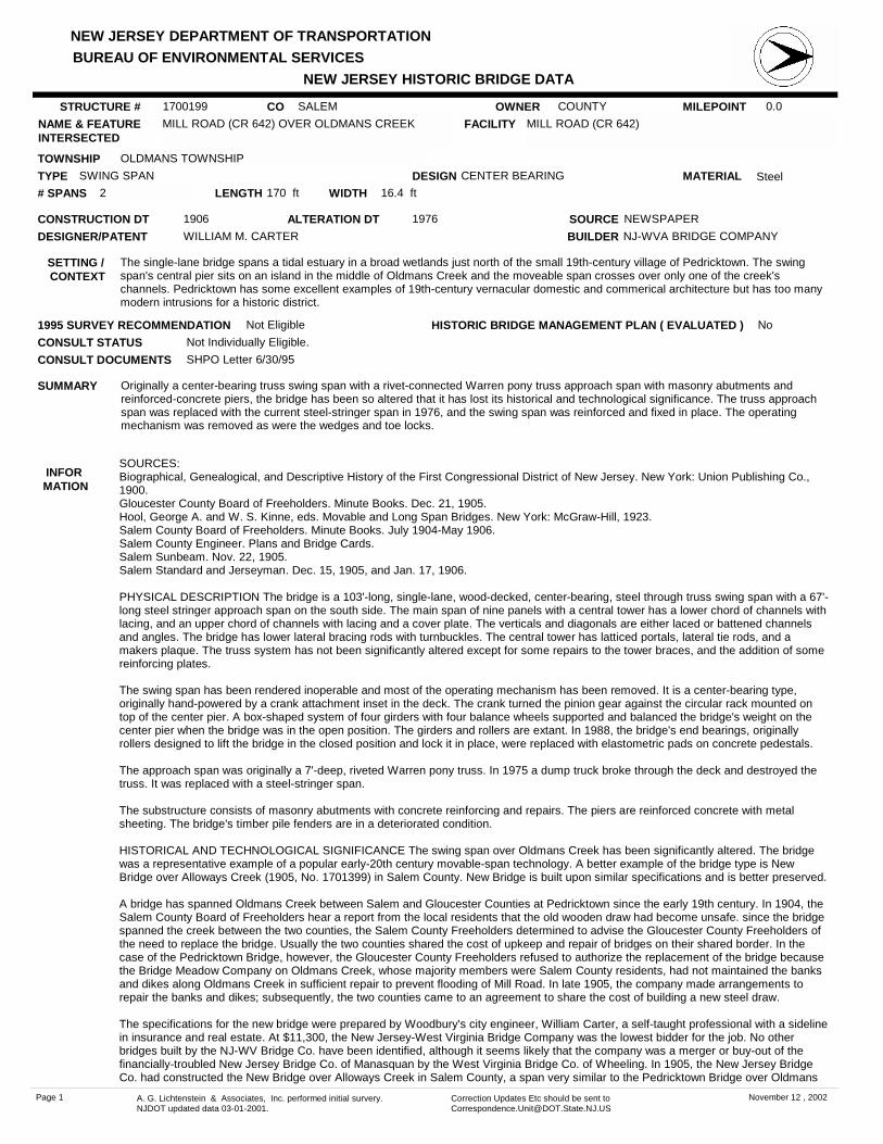
NEW JERSEY DEPARTMENT OF TRANSPORTATION NEW JERSEY HISTORIC BRIDGE DATA BUREAU OF ENVIRONMENTAL SERVICES MILEPOINT 0.0 CO SALEM NAME & FEATURE INTERSECTED MILL ROAD (CR 642) OVER OLDMANS CREEK FACILITY MILL ROAD (CR 642) TOWNSHIP OLDMANS TOWNSHIP OWNER COUNTY CONSTRUCTION DT 1906 SOURCE NEWSPAPER MATERIAL Steel TYPE SWING SPAN LENGTH 170 ft WIDTH 16.4 ft # SPANS 2 DESIGNER/PATENT WILLIAM M. CARTER SETTING / CONTEXT The single-lane bridge spans a tidal estuary in a broad wetlands just north of the small 19th-century village of Pedricktown. The swing span's central pier sits on an island in the middle of Oldmans Creek and the moveable span crosses over only one of the creek's channels. Pedricktown has some excellent examples of 19th-century vernacular domestic and commerical architecture but has too many modern intrusions for a historic district. 1995 SURVEY RECOMMENDATION Not Eligible DESIGN CENTER BEARING BUILDER NJ-WVA BRIDGE COMPANY CONSULT STATUS Not Individually Eligible. SUMMARY Originally a center-bearing truss swing span with a rivet-connected Warren pony truss approach span with masonry abutments and reinforced-concrete piers, the bridge has been so altered that it has lost its historical and technological significance. The truss approach span was replaced with the current steel-stringer span in 1976, and the swing span was reinforced and fixed in place. The operating mechanism was removed as were the wedges and toe locks. STRUCTURE # 1700199 ALTERATION DT 1976 INFOR MATION SOURCES: Biographical, Genealogical, and Descriptive History of the First Congressional District of New Jersey. New York: Union Publishing Co., 1900. Gloucester County Board of Freeholders. Minute Books. Dec. 21, 1905. Hool, George A. and W. S. Kinne, eds. Movable and Long Span Bridges. New York: McGraw-Hill, 1923. Salem County Board of Freeholders. Minute Books. July 1904-May 1906. Salem County Engineer. Plans and Bridge Cards. Salem Sunbeam. Nov. 22, 1905. Salem Standard and Jerseyman. Dec. 15, 1905, and Jan. 17, 1906. PHYSICAL DESCRIPTION The bridge is a 103'-long, single-lane, wood-decked, center-bearing, steel through truss swing span with a 67'- long steel stringer approach span on the south side. The main span of nine panels with a central tower has a lower chord of channels with lacing, and an upper chord of channels with lacing and a cover plate. The verticals and diagonals are either laced or battened channels and angles. The bridge has lower lateral bracing rods with turnbuckles. The central tower has latticed portals, lateral tie rods, and a makers plaque. The truss system has not been significantly altered except for some repairs to the tower braces, and the addition of some reinforcing plates. The swing span has been rendered inoperable and most of the operating mechanism has been removed. It is a center-bearing type, originally hand-powered by a crank attachment inset in the deck. The crank turned the pinion gear against the circular rack mounted on top of the center pier. A box-shaped system of four girders with four balance wheels supported and balanced the bridge's weight on the center pier when the bridge was in the open position. The girders and rollers are extant. In 1988, the bridge's end bearings, originally rollers designed to lift the bridge in the closed position and lock it in place, were replaced with elastometric pads on concrete pedestals. The approach span was originally a 7'-deep, riveted Warren pony truss. In 1975 a dump truck broke through the deck and destroyed the truss. It was replaced with a steel-stringer span. The substructure consists of masonry abutments with concrete reinforcing and repairs. The piers are reinforced concrete with metal sheeting. The bridge's timber pile fenders are in a deteriorated condition. HISTORICAL AND TECHNOLOGICAL SIGNIFICANCE The swing span over Oldmans Creek has been significantly altered. The bridge was a representative example of a popular early-20th century movable-span technology. A better example of the bridge type is New Bridge over Alloways Creek (1905, No. 1701399) in Salem County. New Bridge is built upon similar specifications and is better preserved. A bridge has spanned Oldmans Creek between Salem and Gloucester Counties at Pedricktown since the early 19th century. In 1904, the Salem County Board of Freeholders hear a report from the local residents that the old wooden draw had become unsafe. since the bridge spanned the creek between the two counties, the Salem County Freeholders determined to advise the Gloucester County Freeholders of the need to replace the bridge. Usually the two counties shared the cost of upkeep and repair of bridges on their shared border. In the case of the Pedricktown Bridge, however, the Gloucester County Freeholders refused to authorize the replacement of the bridge because the Bridge Meadow Company on Oldmans Creek, whose majority members were Salem County residents, had not maintained the banks and dikes along Oldmans Creek in sufficient repair to prevent flooding of Mill Road. In late 1905, the company made arrangements to repair the banks and dikes; subsequently, the two counties came to an agreement to share the cost of building a new steel draw. The specifications for the new bridge were prepared by Woodbury's city engineer, William Carter, a self-taught professional with a sideline in insurance and real estate. At $11,300, the New Jersey-West Virginia Bridge Company was the lowest bidder for the job. No other bridges built by the NJ-WV Bridge Co. have been identified, although it seems likely that the company was a merger or buy-out of the financially-troubled New Jersey Bridge Co. of Manasquan by the West Virginia Bridge Co. of Wheeling. In 1905, the New Jersey Bridge Co. had constructed the New Bridge over Alloways Creek in Salem County, a span very similar to the Pedricktown Bridge over Oldmans CONSULT DOCUMENTS SHPO Letter 6/30/95 HISTORIC BRIDGE MANAGEMENT PLAN ( EVALUATED ) No Page 1 A. G. Lichtenstein & Associates, Inc. performed initial survery. NJDOT updated data 03-01-2001. Correction Updates Etc should be sent to [email protected] November 12 , 2002
Transcript of NEW JERSEY DEPARTMENT OF … · lacing, and an upper chord of channels with lacing and a cover...
NEW JERSEY DEPARTMENT OF TRANSPORTATION
NEW JERSEY HISTORIC BRIDGE DATABUREAU OF ENVIRONMENTAL SERVICES
MILEPOINT 0.0CO SALEMNAME & FEATURE INTERSECTED
MILL ROAD (CR 642) OVER OLDMANS CREEK FACILITY MILL ROAD (CR 642)
TOWNSHIP OLDMANS TOWNSHIP
OWNER COUNTY
CONSTRUCTION DT 1906 SOURCE NEWSPAPER
MATERIAL SteelTYPE SWING SPANLENGTH 170 ft WIDTH 16.4 ft# SPANS 2
DESIGNER/PATENT WILLIAM M. CARTER
SETTING / CONTEXT
The single-lane bridge spans a tidal estuary in a broad wetlands just north of the small 19th-century village of Pedricktown. The swing span's central pier sits on an island in the middle of Oldmans Creek and the moveable span crosses over only one of the creek's channels. Pedricktown has some excellent examples of 19th-century vernacular domestic and commerical architecture but has too many modern intrusions for a historic district.
1995 SURVEY RECOMMENDATION Not Eligible
DESIGN CENTER BEARING
BUILDER NJ-WVA BRIDGE COMPANY
CONSULT STATUS Not Individually Eligible.
SUMMARY Originally a center-bearing truss swing span with a rivet-connected Warren pony truss approach span with masonry abutments and reinforced-concrete piers, the bridge has been so altered that it has lost its historical and technological significance. The truss approach span was replaced with the current steel-stringer span in 1976, and the swing span was reinforced and fixed in place. The operating mechanism was removed as were the wedges and toe locks.
STRUCTURE # 1700199
ALTERATION DT 1976
INFOR MATION
SOURCES:Biographical, Genealogical, and Descriptive History of the First Congressional District of New Jersey. New York: Union Publishing Co., 1900.Gloucester County Board of Freeholders. Minute Books. Dec. 21, 1905.Hool, George A. and W. S. Kinne, eds. Movable and Long Span Bridges. New York: McGraw-Hill, 1923.Salem County Board of Freeholders. Minute Books. July 1904-May 1906.Salem County Engineer. Plans and Bridge Cards.Salem Sunbeam. Nov. 22, 1905.Salem Standard and Jerseyman. Dec. 15, 1905, and Jan. 17, 1906.
PHYSICAL DESCRIPTION The bridge is a 103'-long, single-lane, wood-decked, center-bearing, steel through truss swing span with a 67'-long steel stringer approach span on the south side. The main span of nine panels with a central tower has a lower chord of channels with lacing, and an upper chord of channels with lacing and a cover plate. The verticals and diagonals are either laced or battened channels and angles. The bridge has lower lateral bracing rods with turnbuckles. The central tower has latticed portals, lateral tie rods, and a makers plaque. The truss system has not been significantly altered except for some repairs to the tower braces, and the addition of some reinforcing plates.
The swing span has been rendered inoperable and most of the operating mechanism has been removed. It is a center-bearing type, originally hand-powered by a crank attachment inset in the deck. The crank turned the pinion gear against the circular rack mounted on top of the center pier. A box-shaped system of four girders with four balance wheels supported and balanced the bridge's weight on the center pier when the bridge was in the open position. The girders and rollers are extant. In 1988, the bridge's end bearings, originally rollers designed to lift the bridge in the closed position and lock it in place, were replaced with elastometric pads on concrete pedestals.
The approach span was originally a 7'-deep, riveted Warren pony truss. In 1975 a dump truck broke through the deck and destroyed the truss. It was replaced with a steel-stringer span.
The substructure consists of masonry abutments with concrete reinforcing and repairs. The piers are reinforced concrete with metal sheeting. The bridge's timber pile fenders are in a deteriorated condition.
HISTORICAL AND TECHNOLOGICAL SIGNIFICANCE The swing span over Oldmans Creek has been significantly altered. The bridge was a representative example of a popular early-20th century movable-span technology. A better example of the bridge type is New Bridge over Alloways Creek (1905, No. 1701399) in Salem County. New Bridge is built upon similar specifications and is better preserved.
A bridge has spanned Oldmans Creek between Salem and Gloucester Counties at Pedricktown since the early 19th century. In 1904, the Salem County Board of Freeholders hear a report from the local residents that the old wooden draw had become unsafe. since the bridge spanned the creek between the two counties, the Salem County Freeholders determined to advise the Gloucester County Freeholders of the need to replace the bridge. Usually the two counties shared the cost of upkeep and repair of bridges on their shared border. In the case of the Pedricktown Bridge, however, the Gloucester County Freeholders refused to authorize the replacement of the bridge because the Bridge Meadow Company on Oldmans Creek, whose majority members were Salem County residents, had not maintained the banks and dikes along Oldmans Creek in sufficient repair to prevent flooding of Mill Road. In late 1905, the company made arrangements to repair the banks and dikes; subsequently, the two counties came to an agreement to share the cost of building a new steel draw.
The specifications for the new bridge were prepared by Woodbury's city engineer, William Carter, a self-taught professional with a sideline in insurance and real estate. At $11,300, the New Jersey-West Virginia Bridge Company was the lowest bidder for the job. No other bridges built by the NJ-WV Bridge Co. have been identified, although it seems likely that the company was a merger or buy-out of the financially-troubled New Jersey Bridge Co. of Manasquan by the West Virginia Bridge Co. of Wheeling. In 1905, the New Jersey Bridge Co. had constructed the New Bridge over Alloways Creek in Salem County, a span very similar to the Pedricktown Bridge over Oldmans
CONSULT DOCUMENTS SHPO Letter 6/30/95
HISTORIC BRIDGE MANAGEMENT PLAN ( EVALUATED ) No
Page 1 A. G. Lichtenstein & Associates, Inc. performed initial survery. NJDOT updated data 03-01-2001.
Correction Updates Etc should be sent to [email protected]
November 12 , 2002

NEW JERSEY DEPARTMENT OF TRANSPORTATION
NEW JERSEY HISTORIC BRIDGE DATABUREAU OF ENVIRONMENTAL SERVICES
PHOTO: 47:40-42 (09/91) REVISED BY (DATE): QUAD: Marcus Hook
Creek.
The Pedricktown Bridge over Oldmans Creek is not an example of innovative technology. Center-bearing swing spans were popular in the first decades of the 20th century for applications where large channel widths and long periods of interruption to vehicular traffic were not major considerations. The replacement of the approach span and the disablement of the swing span make it a poor candidate for preservation.
Page 2 A. G. Lichtenstein & Associates, Inc. performed initial survery. NJDOT updated data 03-01-2001.
Correction Updates Etc should be sent to [email protected]
November 12 , 2002

NEW JERSEY DEPARTMENT OF TRANSPORTATION
NEW JERSEY HISTORIC BRIDGE DATABUREAU OF ENVIRONMENTAL SERVICES
MILEPOINT 1.45CO SALEMNAME & FEATURE INTERSECTED
HAWK'S BRIDGE ROAD (CR 540) OVER SALEM RIVER
FACILITY HAWK'S BRIDGE ROAD (CR 540)
TOWNSHIP CARNEY'S POINT TOWNSHIP
OWNER COUNTY
CONSTRUCTION DT 1937 SOURCE COUNTY ENGINEER
MATERIAL SteelTYPE STRINGERLENGTH 100 ft WIDTH 40 ft# SPANS 3
DESIGNER/PATENT UNKNOWN
SETTING / CONTEXT
The bridge lies in a small tidal wetlands near the confluence of Salem Creek and the Deepwater Canal leading north to the Delaware River. The bridge spans Salem Creek about 7/10 mile south of the intersection of CR 540, US 40 and the New Jersey Turnpike. Although not visible from the bridge, the area to the north is highly developed with residences, motels, truck stops, and factories (c. 1950-90).
1995 SURVEY RECOMMENDATION Not Eligible
PHOTO: 47:24-25 (09/91) REVISED BY (DATE):
DESIGN
BUILDER UNKNOWN
CONSULT STATUS Not Individually Eligible.
QUAD: Penns Grove
SUMMARY The skewed, steel-stringer bridge has concrete balustrades, encased fascia stringers, and reinforced-concrete substructure. It is one of at least 8 similar existing steel stringers built in Salem County between 1930 and 1941. In 1937-38, the bridge replaced a wooden draw bridge. It is a representative example of a common pre-1946 bridge type in New Jersey, and is not historically or technologically distinguished.
STRUCTURE # 1700200
ALTERATION DT
INFOR MATION
CONSULT DOCUMENTS SHPO Letter 6/30/95
HISTORIC BRIDGE MANAGEMENT PLAN ( EVALUATED ) No
Page 3 A. G. Lichtenstein & Associates, Inc. performed initial survery. NJDOT updated data 03-01-2001.
Correction Updates Etc should be sent to [email protected]
November 12 , 2002

NEW JERSEY DEPARTMENT OF TRANSPORTATION
NEW JERSEY HISTORIC BRIDGE DATABUREAU OF ENVIRONMENTAL SERVICES
MILEPOINT 0.0CO SALEMNAME & FEATURE INTERSECTED
KINGS HIGHWAY (CR 620) OVER SALEM CREEK FACILITY KINGS HIGHWAY (CR 620)
TOWNSHIP PILESGROVE TOWNSHIP
OWNER COUNTY
CONSTRUCTION DT 1919 SOURCE COUNTY ENGINEER
MATERIAL Reinforced Concrete
TYPE T BEAMLENGTH 53 ft WIDTH 22 ft# SPANS 2
DESIGNER/PATENT HOWARD B. KEASBY, CO. ENG.
SETTING / CONTEXT
The two-lane bridge spans Salem Creek in a residential area along tree-lined CR 620 in the village of Sharpstown (c. 1850-1990) about 2/5 mile south of the busy intersection of CR 620 and US 40.
1995 SURVEY RECOMMENDATION Not Eligible
PHOTO: 49:5a-6a (09/91) REVISED BY (DATE):
DESIGN
BUILDER WILLIAM H. SHOUGH
CONSULT STATUS Not Individually Eligible.
QUAD: Woodstown
SUMMARY The continuous T-beam bridge has a reinforced-concrete substructure and beam guide rails. In 1951 the county rebuilt inkind the northern abutment and pier inkind a storm washed out the original substructure. The bridge is one of at least 17 existing T-beam bridges built in Salem County between 1917 and 1944. It is not technologically innovative or historically significant.
STRUCTURE # 1700437
ALTERATION DT 1951
INFOR MATION
CONSULT DOCUMENTS SHPO Letter 6/30/95
HISTORIC BRIDGE MANAGEMENT PLAN ( EVALUATED ) No
Page 4 A. G. Lichtenstein & Associates, Inc. performed initial survery. NJDOT updated data 03-01-2001.
Correction Updates Etc should be sent to [email protected]
November 12 , 2002

NEW JERSEY DEPARTMENT OF TRANSPORTATION
NEW JERSEY HISTORIC BRIDGE DATABUREAU OF ENVIRONMENTAL SERVICES
MILEPOINT 0.0CO SALEMNAME & FEATURE INTERSECTED
MAIN STREET (CR 672) OVER MEMORIAL LAKE FACILITY MAIN STREET (CR 672)
TOWNSHIP WOODSTOWN BOROUGH
OWNER COUNTY
CONSTRUCTION DT 1941 SOURCE PLAQUE
MATERIAL SteelTYPE STRINGERLENGTH 51 ft WIDTH 40 ft# SPANS 2
DESIGNER/PATENT HARRY S. SKINNER, CO. ENG.
SETTING / CONTEXT
The two-lane bridge spans man-made Memorial Lake in Memorial Park on the south side of Woodstown. The borough created the small lakeside park in the early 1920s to commemorate WWI. The surrounding residential area contains houses dating from c.1850 to c.1950. A memorial plaque on the bridge notes that it commemorates nine other bridges destroyed in the flood of 1940. The bridge replaced a steel truss destroyed in the flood.
1995 SURVEY RECOMMENDATION Not Eligible
PHOTO: 47:5-6 (09/91) REVISED BY (DATE):
DESIGN ENCASED
BUILDER JOSEPH W. ROGERS
CONSULT STATUS Not Individually Eligible.
QUAD: Woodstown
SUMMARY The two-span, encased, steel-stringer bridge has reinforced-concrete abutments and pier, and concrete balustrades with decorative Moderne detailing. Except for the embellishments, the bridge is similar to at least 8 other steel-stringer bridges built by Salem County between 1930 and 1941. The bridge is not historically or technologically distinguished.
STRUCTURE # 1700448
ALTERATION DT
INFOR MATION
CONSULT DOCUMENTS SHPO Letter 6/30/95
HISTORIC BRIDGE MANAGEMENT PLAN ( EVALUATED ) No
Page 5 A. G. Lichtenstein & Associates, Inc. performed initial survery. NJDOT updated data 03-01-2001.
Correction Updates Etc should be sent to [email protected]
November 12 , 2002

NEW JERSEY DEPARTMENT OF TRANSPORTATION
NEW JERSEY HISTORIC BRIDGE DATABUREAU OF ENVIRONMENTAL SERVICES
MILEPOINT 0.0CO SALEMNAME & FEATURE INTERSECTED
MILL STREET OVER MEMORIAL LAKE SPILLWAY FACILITY MILL STREET
TOWNSHIP WOODSTOWN BOROUGH
OWNER COUNTY
CONSTRUCTION DT 1922 SOURCE COUNTY ENGINEER
MATERIAL Reinforced Concrete
TYPE T BEAMLENGTH 47 ft WIDTH 20 ft# SPANS 2
DESIGNER/PATENT HOWARD B. KEASBY, CO. ENG.
SETTING / CONTEXT
The one-lane bridge spans the spillway from Memorial Lake in Memorial Park on the south side of Woodstown. The borough created the lakeside park in the early 1920s to commemorate WWI. The area surrounding the park is residential (c. 1850-1950). The bridge is structurally associated with the U-shaped spillway/dam that creates Memorial Lake. The center of the spillway once had a fountain. The park does not appear to be NR eligible.
1995 SURVEY RECOMMENDATION Not Eligible
PHOTO: 47:7-9 (09/91) REVISED BY (DATE):
DESIGN
BUILDER KUCHAR BROTHERS
CONSULT STATUS Not Individually Eligible.
QUAD: Woodstown
SUMMARY The two-span, T-beam bridge with concrete balustrades and substructure is representative of at least 17 examples of the bridge type built in the county between 1917 and 1944. Its setting in a 1920s memorial park is well preserved, but the bridge itself is technologically and historically undistinguished. Utility pipes and a steel platform have been added. The bridge's local historic value is not sufficient to meet National Register criteria.
STRUCTURE # 1700449
ALTERATION DT
INFOR MATION
SOURCES:Combination Atlas and Map of Salem and Gloucester Counties. Philadelphia: Everts and Stewart, 1876.Salem County Board of Freeholders. Minute Books. May 10, 1922 and Nov. 15, 1922.Ketchum, Milo S. The Design of Highway Bridges of Steel, Timber and Concrete. New York: McGraw-Hill, 1920.Shuck, Albert C., et. al. "A Story of Salem County." Typescript. Salem City Public Library. 1938.
PHYSICAL DESCRIPTION The two-span, concrete T-beam bridge has concrete balustrades and substructure. A T-beam bridge is characterized by reinforced concrete beams with T-shaped reinforcing bars. Structurally associated with the bridge is a stepped, semi-circular spillway/dam with a central water fountain display. Molded into the spillway walls are the words "Memorial Lake." The dam/spillway creates Memorial Lake, the central feature of Woodstown's Memorial Park. The bridge has not been significantly altered, but the spillway and fountain are in poor repair. A utility pipe has been suspended from the bridge, and a steel platform erected over the spillway next to the south abutment.
HISTORICAL AND TECHNOLOGICAL SIGNIFICANCE The Memorial Lake Bridge is one of the most distinguished of over 15 similar, short-span T-beam bridges built in Salem County between 1917 and 1944. It is structurally associated with a spillway/dam, and is located in Woodstown's largest city park. The T-beam was a standardized bridge design that came into wide use in Salem County during the tenure of the county's first professional engineer, Howard B. Keasby. The bridge is one of the best examples of a bridge type of local historic importance, but it is not significant enough to merit National Register recognition.
Shortly after WWI, Woodstown bought the Memorial Lake property for a city park, commemorating its wartime veterans. The property had formerly been the site of a grist mill with mill pond. An 1876 map shows a bridge spanning the mill pond spillway and a grist mill downstream from the bridge. The mill buildings no longer exist. In 1922 the worn-out wood-stringer bridge was replaced with a new T-beam bridge. The county was in the midst of a campaign to replace many of its wood bridges with concrete or steel. The plans for the Memorial Lake Bridge included "two spans of 30', a gravel roadway 2' higher than the old bridge, and a tumbling dam." The bridge was to be paid for by the county, and the "tumbling dam" by the Woodstown Chamber of Commerce. The contract to build the new bridge was awarded at a price of $13,240.47 to Kuchar Brothers, contractors from Spring Valley, New York. Kuchar Brothers also held large contracts for improvements to the newly-created state highways in Salem County.
CONSULT DOCUMENTS SHPO Letter 6/30/95
HISTORIC BRIDGE MANAGEMENT PLAN ( EVALUATED ) No
Page 6 A. G. Lichtenstein & Associates, Inc. performed initial survery. NJDOT updated data 03-01-2001.
Correction Updates Etc should be sent to [email protected]
November 12 , 2002

NEW JERSEY DEPARTMENT OF TRANSPORTATION
NEW JERSEY HISTORIC BRIDGE DATABUREAU OF ENVIRONMENTAL SERVICES
MILEPOINT 0.0CO SALEMNAME & FEATURE INTERSECTED
EAST LAKE ROAD OVER SALEM CREEK FACILITY EAST LAKE ROAD
TOWNSHIP PILESGROVE TOWNSHIP
OWNER COUNTY
CONSTRUCTION DT 1921 SOURCE COUNTY ENGINEER
MATERIAL Reinforced Concrete
TYPE T BEAMLENGTH 34 ft WIDTH 21.6 ft# SPANS 1
DESIGNER/PATENT UNKNOWN
SETTING / CONTEXT
The bridge spans the spillway from Webster Mill Pond south of Woodstown. The surrounding area is rural with cow pastures, dairy barns, and residences (c. 1830-1990). A circular-shaped concrete dam and spillway extends from the bridge abutments to create the 3/5-mile long pond. The structural association of bridges and dams is frequent in South Jersey.
1995 SURVEY RECOMMENDATION Not Eligible
PHOTO: 49:2a-4a (09/91) REVISED BY (DATE):
DESIGN
BUILDER WILLIAM H. SHOUGH
CONSULT STATUS Not Individually Eligible.
QUAD: Woodstown
SUMMARY The single-span, T-beam bridge with reinforced-concrete abutments is representative of at least 17 existing T-beams built in Salem County between 1917 and 1944. The county has replaced the original railings with steel guide rails. William H. Shough of Alloway, NJ, built at least seven of the county's existing T-beams. The bridge is not historically or technologically significant.
STRUCTURE # 1700455
ALTERATION DT
INFOR MATION
CONSULT DOCUMENTS SHPO Letter 6/30/95
HISTORIC BRIDGE MANAGEMENT PLAN ( EVALUATED ) No
Page 7 A. G. Lichtenstein & Associates, Inc. performed initial survery. NJDOT updated data 03-01-2001.
Correction Updates Etc should be sent to [email protected]
November 12 , 2002

NEW JERSEY DEPARTMENT OF TRANSPORTATION
NEW JERSEY HISTORIC BRIDGE DATABUREAU OF ENVIRONMENTAL SERVICES
MILEPOINT 0.0CO SALEMNAME & FEATURE INTERSECTED
SWEDESBORO ROAD (CR 605) OVER OLDMANS CREEK
FACILITY SWEDESBORO ROAD (CR 605)
TOWNSHIP PILESGROVE TOWNSHIP
OWNER COUNTY
CONSTRUCTION DT 1923 SOURCE COUNTY ENGINEER
MATERIAL Reinforced Concrete
TYPE ARCHLENGTH 38 ft WIDTH 29.6 ft# SPANS 1
DESIGNER/PATENT HOWARD B. KEASBY, CO. ENG.
SETTING / CONTEXT
The bridge spans a tree-lined creek on the Gloucester-Salem County line. The surrounding area is rural with wooded lots, scattered residences (c. 1850-1990), and fields.
1995 SURVEY RECOMMENDATION Not Eligible
PHOTO: 47:43-44 (09/91) REVISED BY (DATE):
DESIGN BARREL
BUILDER E. P. HENRY AND SON
CONSULT STATUS Not Individually Eligible.
QUAD: Woodstown
SUMMARY The reinforced-concrete arch with concrete parapets spans the county line, and was jointly built by Gloucester and Salem Counties. The bridge is similar to at least 19 arches built between 1912 and 1940 in Gloucester County. No other similar arches are in Salem County. Probably plans provided by Gloucester County engineer William C. Cattell were used. The bridge is not historically or technologically distinguished.
STRUCTURE # 1700482
ALTERATION DT
INFOR MATION
CONSULT DOCUMENTS SHPO Letter 6/30/95
HISTORIC BRIDGE MANAGEMENT PLAN ( EVALUATED ) No
Page 8 A. G. Lichtenstein & Associates, Inc. performed initial survery. NJDOT updated data 03-01-2001.
Correction Updates Etc should be sent to [email protected]
November 12 , 2002

NEW JERSEY DEPARTMENT OF TRANSPORTATION
NEW JERSEY HISTORIC BRIDGE DATABUREAU OF ENVIRONMENTAL SERVICES
MILEPOINT 0.0CO SALEMNAME & FEATURE INTERSECTED
CR 540 OVER MANNINGTON CREEK FACILITY CR 540 (POINTERS-AUBURN ROAD)
TOWNSHIP MANNINGTON TOWNSHIP
OWNER COUNTY
CONSTRUCTION DT 1939 SOURCE COUNTY ENGINEER
MATERIAL Reinforced Concrete
TYPE SLABLENGTH 54 ft WIDTH 31.3 ft# SPANS 4
DESIGNER/PATENT UNKNOWN
SETTING / CONTEXT
The two-lane bridge spans a tidal estuary in broad wetlands near the tidal pond known as Mannington Meadow. On the upstream side of the bridge is a timber tidal barrier and gates supported by lateral I-beams bolted to the bridge. The bridge is a favorite spot of fishermen, and the surrounding area is largely undeveloped. The structural association of bridges and dams is frequent in South Jersey.
1995 SURVEY RECOMMENDATION Not Eligible
PHOTO: 47:16-17 (09/91) REVISED BY (DATE):
DESIGN
BUILDER UNKNOWN
CONSULT STATUS Not Individually Eligible.
QUAD: Salem
SUMMARY The concrete slab with balustrades and reinforced-concrete substructure is the longest in Salem County. In 1972 the county substantially rebuilt the adjoining tidal barrier. Concrete slabs are a common bridge type in New Jersey. The bridge is not historically or technologically distinguished.
STRUCTURE # 1700505
ALTERATION DT 1972
INFOR MATION
CONSULT DOCUMENTS SHPO Letter 6/30/95
HISTORIC BRIDGE MANAGEMENT PLAN ( EVALUATED ) No
Page 9 A. G. Lichtenstein & Associates, Inc. performed initial survery. NJDOT updated data 03-01-2001.
Correction Updates Etc should be sent to [email protected]
November 12 , 2002

NEW JERSEY DEPARTMENT OF TRANSPORTATION
NEW JERSEY HISTORIC BRIDGE DATABUREAU OF ENVIRONMENTAL SERVICES
MILEPOINT 0.0CO SALEMNAME & FEATURE INTERSECTED
KINGS HIGHWAY (CR 620) OVER MANNINGTON CREEK
FACILITY KINGS HIGHWAY (CR 620)
TOWNSHIP MANNINGTON TOWNSHIP
OWNER COUNTY
CONSTRUCTION DT 1931 SOURCE COUNTY ENGINEER
MATERIAL Reinforced Concrete
TYPE T BEAMLENGTH 70 ft WIDTH 31.8 ft# SPANS 3
DESIGNER/PATENT UNKNOWN
SETTING / CONTEXT
The two-lane bridge spans a tidal estuary in broad wetlands near the Delaware River. The surrounding area is undeveloped and the bridge is a favorite spot of fishermen.
1995 SURVEY RECOMMENDATION Not Eligible
PHOTO: 400:2-3 (09/91) REVISED BY (DATE):
DESIGN
BUILDER C. FISKE CAMPBELL
CONSULT STATUS Not Individually Eligible.
QUAD: Salem
SUMMARY The three-span T-beam bridge with reinforced-concrete substructure has balustrades on the center span and paneled parapets on the approach spans. The bridge is a representative example of at least 17 similar T-beam bridges built in Salem County between 1917 and 1944. C. F. Campbell of Bridgeton constructed at least six concrete bridges in the county between 1928 and 1933. The bridge is not historically or technologically distinguished.
STRUCTURE # 1700573
ALTERATION DT
INFOR MATION
CONSULT DOCUMENTS SHPO Letter 6/30/95
HISTORIC BRIDGE MANAGEMENT PLAN ( EVALUATED ) No
Page 10 A. G. Lichtenstein & Associates, Inc. performed initial survery. NJDOT updated data 03-01-2001.
Correction Updates Etc should be sent to [email protected]
November 12 , 2002

NEW JERSEY DEPARTMENT OF TRANSPORTATION
NEW JERSEY HISTORIC BRIDGE DATABUREAU OF ENVIRONMENTAL SERVICES
MILEPOINT 0.0CO SALEMNAME & FEATURE INTERSECTED
LAKE STREET OVER BRANCH OF ALLOWAYS CREEK
FACILITY LAKE STREET
TOWNSHIP QUINTON TOWNSHIP
OWNER COUNTY
CONSTRUCTION DT 1928 SOURCE COUNTY ENGINEER
MATERIAL Reinforced Concrete
TYPE T BEAMLENGTH 32 ft WIDTH 30 ft# SPANS 1
DESIGNER/PATENT UNKNOWN
SETTING / CONTEXT
The two-lane bridge spans the spillway from Laurel Lake Reservoir in the village of Quinton. Just east of the bridge is a concrete dam creating the reservoir, and nearby at the corner of Lake Street and Waterworks Road is a brick pumping station (c. 1920-30). The surrounding neighborhood is residential with many houses dating from the 19th century.
1995 SURVEY RECOMMENDATION Not Eligible
PHOTO: 48:35-36 (09/91) REVISED BY (DATE):
DESIGN
BUILDER C. FISKE CAMPBELL
CONSULT STATUS Not Individually Eligible. Potential Quinton's Bridge Historic District. Contributing.
QUAD: Salem
SUMMARY The single-span T-beam bridge with balustrades and reinforced-concrete substructure is a representative example of at least 17 similar T-beam bridges built by Salem County between 1917 and 1944. C. F. Campbell, the builder, constructed at least six concrete bridges in the county from 1928 to 1933. The bridge is not historically or technologically significant.
STRUCTURE # 1700954
ALTERATION DT
INFOR MATION
CONSULT DOCUMENTS SHPO Letter 6/30/95
HISTORIC BRIDGE MANAGEMENT PLAN ( EVALUATED ) No
Page 11 A. G. Lichtenstein & Associates, Inc. performed initial survery. NJDOT updated data 03-01-2001.
Correction Updates Etc should be sent to [email protected]
November 12 , 2002

NEW JERSEY DEPARTMENT OF TRANSPORTATION
NEW JERSEY HISTORIC BRIDGE DATABUREAU OF ENVIRONMENTAL SERVICES
MILEPOINT 0.0CO SALEMNAME & FEATURE INTERSECTED
WATER WORKS ROAD OVER DEEP RUN FACILITY WATERWORKS ROAD
TOWNSHIP QUINTON TOWNSHIP
OWNER COUNTY
CONSTRUCTION DT 1923 SOURCE COUNTY ENGINEER
MATERIAL Reinforced Concrete
TYPE T BEAMLENGTH 30 ft WIDTH 20 ft# SPANS 1
DESIGNER/PATENT UNKNOWN
SETTING / CONTEXT
The single-lane bridge spans a spillway from the Elkinton Mill Pond dam. To the west of the bridge and extending from the abutments is a U-shaped, concrete spillway/dam. Trees line the banks of the creek and the pond, and the surrounding area is rural with fields and wooded lots. A brick water pump station (c. 1920-30) is next to the bridge. The structural association of bridges and dams is frequent in South Jersey.
1995 SURVEY RECOMMENDATION Not Eligible
PHOTO: 48:37-39 (09/91) REVISED BY (DATE):
DESIGN
BUILDER WILLIAM H. SHOUGH
CONSULT STATUS Not Individually Eligible.
QUAD: Alloway
SUMMARY The T-beam bridge with concrete balustrades and reinforced-concrete substructure is a representative example of at least 17 similar T-beams built in Salem County from 1917 to 1944. Builder W. H. Shough of Alloway constructed at least seven of the county's T-beam bridges. The bridge is not historically or technologically significant.
STRUCTURE # 1700973
ALTERATION DT
INFOR MATION
CONSULT DOCUMENTS SHPO Letter 6/30/95
HISTORIC BRIDGE MANAGEMENT PLAN ( EVALUATED ) No
Page 12 A. G. Lichtenstein & Associates, Inc. performed initial survery. NJDOT updated data 03-01-2001.
Correction Updates Etc should be sent to [email protected]
November 12 , 2002

NEW JERSEY DEPARTMENT OF TRANSPORTATION
NEW JERSEY HISTORIC BRIDGE DATABUREAU OF ENVIRONMENTAL SERVICES
MILEPOINT 0.0CO SALEMNAME & FEATURE INTERSECTED
TELEGRAPH ROAD (CR 540) OVER DEEP RUN FACILITY TELEGRAPH ROAD (CR 540)
TOWNSHIP ALLOWAY TOWNSHIP
OWNER COUNTY
CONSTRUCTION DT 1924 SOURCE COUNTY ENGINEER
MATERIAL Reinforced Concrete
TYPE T BEAMLENGTH 31 ft WIDTH 30 ft# SPANS 1
DESIGNER/PATENT UNKNOWN
SETTING / CONTEXT
The two-lane bridge spans a small creek in a rural section of Salem County. Paralleling the tree-lined road are farmers' fields and wooded lots. A small pond is downstream from the bridge.
1995 SURVEY RECOMMENDATION Not Eligible
PHOTO: 48:4-5 (09/91) REVISED BY (DATE):
DESIGN
BUILDER SAMUEL CAMPBELL
CONSULT STATUS Not Individually Eligible.
QUAD: Alloway
SUMMARY The single-span T-beam bridge with concrete balustrades and reinforced-concrete abutments is a representative example of at least 17 similar T-beam bridges built in Salem County between 1917 and 1944. Builder Samuel Campbell of Bridgeton constructed the bridge, which according to county records replaced a timber-stringer bridge. The bridge is not historically or technologically significant.
STRUCTURE # 1701003
ALTERATION DT
INFOR MATION
CONSULT DOCUMENTS SHPO Letter 6/30/95
HISTORIC BRIDGE MANAGEMENT PLAN ( EVALUATED ) No
Page 13 A. G. Lichtenstein & Associates, Inc. performed initial survery. NJDOT updated data 03-01-2001.
Correction Updates Etc should be sent to [email protected]
November 12 , 2002
NEW JERSEY DEPARTMENT OF TRANSPORTATION
NEW JERSEY HISTORIC BRIDGE DATABUREAU OF ENVIRONMENTAL SERVICES
MILEPOINT 0.0CO SALEMNAME & FEATURE INTERSECTED
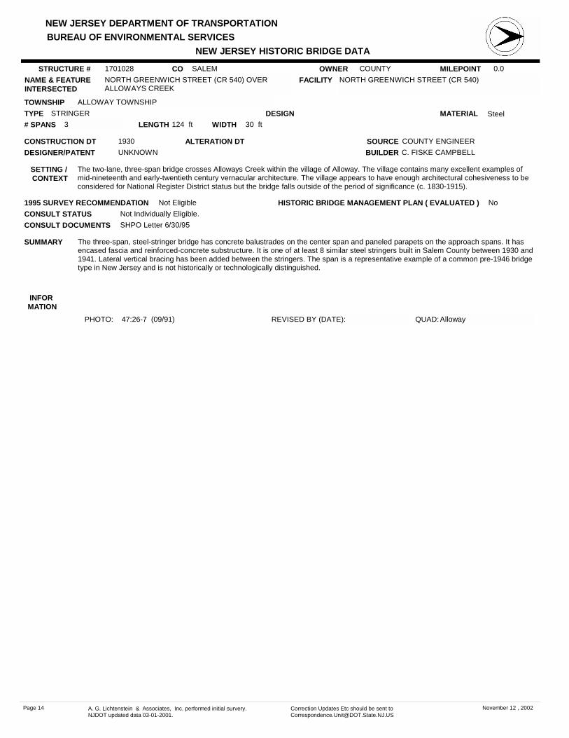
NORTH GREENWICH STREET (CR 540) OVER ALLOWAYS CREEK
FACILITY NORTH GREENWICH STREET (CR 540)
TOWNSHIP ALLOWAY TOWNSHIP
OWNER COUNTY
CONSTRUCTION DT 1930 SOURCE COUNTY ENGINEER
MATERIAL SteelTYPE STRINGERLENGTH 124 ft WIDTH 30 ft# SPANS 3
DESIGNER/PATENT UNKNOWN
SETTING / CONTEXT
The two-lane, three-span bridge crosses Alloways Creek within the village of Alloway. The village contains many excellent examples of mid-nineteenth and early-twentieth century vernacular architecture. The village appears to have enough architectural cohesiveness to be considered for National Register District status but the bridge falls outside of the period of significance (c. 1830-1915).
1995 SURVEY RECOMMENDATION Not Eligible
PHOTO: 47:26-7 (09/91) REVISED BY (DATE):
DESIGN
BUILDER C. FISKE CAMPBELL
CONSULT STATUS Not Individually Eligible.
QUAD: Alloway
SUMMARY The three-span, steel-stringer bridge has concrete balustrades on the center span and paneled parapets on the approach spans. It has encased fascia and reinforced-concrete substructure. It is one of at least 8 similar steel stringers built in Salem County between 1930 and 1941. Lateral vertical bracing has been added between the stringers. The span is a representative example of a common pre-1946 bridge type in New Jersey and is not historically or technologically distinguished.
STRUCTURE # 1701028
ALTERATION DT
INFOR MATION
CONSULT DOCUMENTS SHPO Letter 6/30/95
HISTORIC BRIDGE MANAGEMENT PLAN ( EVALUATED ) No
Page 14 A. G. Lichtenstein & Associates, Inc. performed initial survery. NJDOT updated data 03-01-2001.
Correction Updates Etc should be sent to [email protected]
November 12 , 2002

NEW JERSEY DEPARTMENT OF TRANSPORTATION
NEW JERSEY HISTORIC BRIDGE DATABUREAU OF ENVIRONMENTAL SERVICES
MILEPOINT 0.0CO SALEMNAME & FEATURE INTERSECTED
CR 581 OVER DEEP RUN FACILITY CR 581
TOWNSHIP ALLOWAY TOWNSHIP
OWNER COUNTY
CONSTRUCTION DT 1941 SOURCE PLAQUE
MATERIAL SteelTYPE STRINGERLENGTH 29 ft WIDTH 30.2 ft# SPANS 1
DESIGNER/PATENT UNKNOWN
SETTING / CONTEXT
The two-lane bridge spans a creek about 1/2 mile west of the nineteenth-century village of Alloway. The surrounding area is rural with farmers fields, wooded lots, and residences (c. 1920-1980).
1995 SURVEY RECOMMENDATION Not Eligible
PHOTO: 48:30-31 (09/91) REVISED BY (DATE):
DESIGN
BUILDER UNKNOWN
CONSULT STATUS Not Individually Eligible.
QUAD: Alloway
SUMMARY The single-span, steel-stringer bridge with concrete balustrades, encased fascia, and reinforced-concrete substructure is a representative example of at least 8 similar steel stringers built in Salem County between 1930 and 1941. Steel stringers are a common pre-1946 bridge type in New Jersey. The bridge is not historically or technologically distinguished.
STRUCTURE # 1701030
ALTERATION DT
INFOR MATION
CONSULT DOCUMENTS SHPO Letter 6/30/95
HISTORIC BRIDGE MANAGEMENT PLAN ( EVALUATED ) No
Page 15 A. G. Lichtenstein & Associates, Inc. performed initial survery. NJDOT updated data 03-01-2001.
Correction Updates Etc should be sent to [email protected]
November 12 , 2002

NEW JERSEY DEPARTMENT OF TRANSPORTATION
NEW JERSEY HISTORIC BRIDGE DATABUREAU OF ENVIRONMENTAL SERVICES
MILEPOINT 0.0CO SALEMNAME & FEATURE INTERSECTED
CAMP EDGE ROAD OVER CARLISLE RUN FACILITY CAMP EDGE ROAD
TOWNSHIP ALLOWAY TOWNSHIP
OWNER COUNTY
CONSTRUCTION DT 1927 SOURCE COUNTY ENGINEER
MATERIAL Reinforced Concrete
TYPE T BEAMLENGTH 34 ft WIDTH 20.2 ft# SPANS 1
DESIGNER/PATENT UNKNOWN
SETTING / CONTEXT
The narrow two-lane bridge spans a shallow creek 50 yards downstream from Lake Sycamore, a privately-owned lake and campground in the small village of Remsterville. About 100 feet to the east near the intersection of Camp Edge Road and CR611 are two early-19th century homes with some alterations. The area to the west of the bridge is densely wooded.
1995 SURVEY RECOMMENDATION Not Eligible
PHOTO: 48:2-3 (09/91) REVISED BY (DATE):
DESIGN
BUILDER WILLIAM H. SHOUGH
CONSULT STATUS Not Individually Eligible.
QUAD: Alloway
SUMMARY The single-span T-beam bridge with concrete balustrades and reinforced-concrete substructure is a representative example of at least 17 similar T-beams built by Salem County between 1917 and 1944. Builder W. H. Shough of Alloway constructed at least seven of the county's T-beam bridges. The span replaced an earlier timber stringer bridge. The bridge is not historically or technologically significant.
STRUCTURE # 1701040
ALTERATION DT
INFOR MATION
CONSULT DOCUMENTS SHPO Letter 6/30/95
HISTORIC BRIDGE MANAGEMENT PLAN ( EVALUATED ) No
Page 16 A. G. Lichtenstein & Associates, Inc. performed initial survery. NJDOT updated data 03-01-2001.
Correction Updates Etc should be sent to [email protected]
November 12 , 2002

NEW JERSEY DEPARTMENT OF TRANSPORTATION
NEW JERSEY HISTORIC BRIDGE DATABUREAU OF ENVIRONMENTAL SERVICES
MILEPOINT 0.0CO SALEMNAME & FEATURE INTERSECTED
WITT ROAD OVER ALLOWAYS CREEK FACILITY WITT ROAD
TOWNSHIP ALLOWAY TOWNSHIP
OWNER COUNTY
CONSTRUCTION DT 1920 SOURCE COUNTY ENGINEER
MATERIAL SteelTYPE STRINGERLENGTH 34 ft WIDTH 30.2 ft# SPANS 1
DESIGNER/PATENT UNKNOWN
SETTING / CONTEXT
The two-lane bridge spans a small creek near a cow pasture. The surrounding area is rural with fields, wooded lots and scattered residences (c. 1830-1980).
1995 SURVEY RECOMMENDATION Not Eligible
PHOTO: 48:42-43 (09/91) REVISED BY (DATE):
DESIGN
BUILDER UNKNOWN
CONSULT STATUS Not Individually Eligible.
QUAD: Alloway
SUMMARY According to county records, in 1965, Foundations and Structures, Inc. of Linwood, NJ, widened each side of an existing 15' wide, steel-stringer bridge with the addition of two 6'-wide prestressed concrete beams and parapets. The concrete substructure was also widened. The original design of the bridge has been substantially altered. The bridge is not historically or technologically significant.
STRUCTURE # 1701073
ALTERATION DT 1965
INFOR MATION
CONSULT DOCUMENTS SHPO Letter 6/30/95
HISTORIC BRIDGE MANAGEMENT PLAN ( EVALUATED ) No
Page 17 A. G. Lichtenstein & Associates, Inc. performed initial survery. NJDOT updated data 03-01-2001.
Correction Updates Etc should be sent to [email protected]
November 12 , 2002

NEW JERSEY DEPARTMENT OF TRANSPORTATION
NEW JERSEY HISTORIC BRIDGE DATABUREAU OF ENVIRONMENTAL SERVICES
MILEPOINT 0.0CO SALEMNAME & FEATURE INTERSECTED
COMMISSIONERS PIKE (CR 581) OVER ALLOWAYS CREEK
FACILITY COMMISSIONERS PIKE (CR 581)
TOWNSHIP ALLOWAY TOWNSHIP
OWNER COUNTY
CONSTRUCTION DT 1932 SOURCE COUNTY ENGINEER
MATERIAL SteelTYPE STRINGERLENGTH 52 ft WIDTH 30 ft# SPANS 1
DESIGNER/PATENT UNKNOWN
SETTING / CONTEXT
The two-lane bridge spans a small creek along a tree-lined county road. The surrounding area is rural with pastures, wooded lots, fields, and scattered homes (c. 1800-1990).
1995 SURVEY RECOMMENDATION Not Eligible
PHOTO: 48:1,44 (09/91) REVISED BY (DATE):
DESIGN
BUILDER C. FISKE CAMPBELL
CONSULT STATUS Not Individually Eligible.
QUAD: Alloway
SUMMARY The single-span, steel-stringer bridge with balustrades, encased fascia, and reinforced-concrete substructure is a representative example of at least 16 similar steel-stringer bridges built in Salem County between 1930 and 1941. Builder C. Fiske Campbell of Bridgeton constructed the bridge, which replaced an earlier 24' wood stringer bridge. Steel-stringer bridges are a common type of pre-1946 bridge in New Jersey. The span is not historically or technologically distinguished.
STRUCTURE # 1701074
ALTERATION DT
INFOR MATION
CONSULT DOCUMENTS SHPO Letter 6/30/95
HISTORIC BRIDGE MANAGEMENT PLAN ( EVALUATED ) No
Page 18 A. G. Lichtenstein & Associates, Inc. performed initial survery. NJDOT updated data 03-01-2001.
Correction Updates Etc should be sent to [email protected]
November 12 , 2002

NEW JERSEY DEPARTMENT OF TRANSPORTATION
NEW JERSEY HISTORIC BRIDGE DATABUREAU OF ENVIRONMENTAL SERVICES
MILEPOINT 0.0CO SALEMNAME & FEATURE INTERSECTED
PLEASANT HILL ROAD OVER ALLOWAYS CREEK FACILITY PLEASANT HILL ROAD
TOWNSHIP ALLOWAY TOWNSHIP
OWNER COUNTY
CONSTRUCTION DT 1932 SOURCE COUNTY ENGINEER
MATERIAL SteelTYPE STRINGERLENGTH 45 ft WIDTH 20.3 ft# SPANS 1
DESIGNER/PATENT UNKNOWN
SETTING / CONTEXT
The single-lane bridge spans a shallow creek in a wooded area near some farmers' fields in a rural section of eastern Alloway Township. The bridge is skewed at about 40 degrees.
1995 SURVEY RECOMMENDATION Not Eligible
PHOTO: 48:9-10 (09/91) REVISED BY (DATE):
DESIGN
BUILDER C. FISKE CAMPBELL
CONSULT STATUS Not Individually Eligible.
QUAD: Alloway
SUMMARY The skewed, single-span, steel-stringer bridge with pipe railing has a concrete deck and reinforced-concrete abutments. Builder C. Fiske Campbell of Bridgeton constructed the bridge which replaced a 16'-span wood stringer bridge. Steel stringers are a common pre-1946 bridge type in New Jersey. In Salem County alone there are at least 24 steel-stringer bridges. The span is not historically or technologically distinguished.
STRUCTURE # 1701088
ALTERATION DT
INFOR MATION
CONSULT DOCUMENTS SHPO Letter 6/30/95
HISTORIC BRIDGE MANAGEMENT PLAN ( EVALUATED ) No
Page 19 A. G. Lichtenstein & Associates, Inc. performed initial survery. NJDOT updated data 03-01-2001.
Correction Updates Etc should be sent to [email protected]
November 12 , 2002

NEW JERSEY DEPARTMENT OF TRANSPORTATION
NEW JERSEY HISTORIC BRIDGE DATABUREAU OF ENVIRONMENTAL SERVICES
MILEPOINT 0.0CO SALEMNAME & FEATURE INTERSECTED
WOODSTOWN ROAD (CR 603) OVER ALLOWAYS CREEK
FACILITY WOODSTOWN ROAD (CR 603)
TOWNSHIP ALLOWAY TOWNSHIP
OWNER COUNTY
CONSTRUCTION DT 1941 SOURCE PLAQUE
MATERIAL SteelTYPE STRINGERLENGTH 30 ft WIDTH 30.1 ft# SPANS 1
DESIGNER/PATENT UNKNOWN
SETTING / CONTEXT
The two-lane bridge spans Alloways Creek along a tree-lined section of county highway. To the west, Alloways Creek flows into Alloway Lake, a dammed portion of the stream. Houses (c. 1920-90) on large wooded lots surround the lake.
1995 SURVEY RECOMMENDATION Not Eligible
PHOTO: 48:40-41 (09/91) REVISED BY (DATE):
DESIGN
BUILDER UNKNOWN
CONSULT STATUS Not Individually Eligible.
QUAD: Alloway
SUMMARY The single-span, steel-stringer bridge with concrete balustrades, encased fascia, and reinforced concrete substructure is a representative example of at least 8 similar steel stringers built by Salem County between 1930 and 1941. Steel stringers are a common pre-1946 bridge type in New Jersey. The span is not historically or technologically distinguished.
STRUCTURE # 1701097
ALTERATION DT
INFOR MATION
CONSULT DOCUMENTS SHPO Letter 6/30/95
HISTORIC BRIDGE MANAGEMENT PLAN ( EVALUATED ) No
Page 20 A. G. Lichtenstein & Associates, Inc. performed initial survery. NJDOT updated data 03-01-2001.
Correction Updates Etc should be sent to [email protected]
November 12 , 2002

NEW JERSEY DEPARTMENT OF TRANSPORTATION
NEW JERSEY HISTORIC BRIDGE DATABUREAU OF ENVIRONMENTAL SERVICES
MILEPOINT 2.61CO SALEMNAME & FEATURE INTERSECTED
US 40 WB OVER WEST BRANCH OF GAME CREEK FACILITY US 40 WESTBOUND
TOWNSHIP CARNEY'S POINT TOWNSHIP
OWNER NJDOT
CONSTRUCTION DT 1941 SOURCE NJDOT
MATERIAL Reinforced Concrete
TYPE T BEAMLENGTH 53 ft WIDTH 38 ft# SPANS 2
DESIGNER/PATENT UNKNOWN
SETTING / CONTEXT
The two-lane bridge spans a wide creek 9/10 mile east of the busy intersection of US 40 and the New Jersey Turnpike. The Turnpike spans the West Branch of Game Creek about 1/10 mile north of the bridge. Immediately south of the bridge is a small boat launching area. To the west the area is heavily developed with truck stops, motels, and restaurants (c. 1950-80).
1995 SURVEY RECOMMENDATION Not Eligible
PHOTO: 47:22-23 (09/91) REVISED BY (DATE):
DESIGN
BUILDER UNKNOWN
CONSULT STATUS Not Individually Eligible.
QUAD: Penns Grove
SUMMARY The two-span, T-beam bridge with balustrades and reinforced-concrete substructure is a representative example of at least 17 similar T-beam bridges built by Salem County between 1917 and 1944. The county-built bridge was added to the state highway system in the 1950s. It is not historically or technologically significant.
STRUCTURE # 1701151
ALTERATION DT
INFOR MATION
CONSULT DOCUMENTS SHPO Letter 6/30/95
HISTORIC BRIDGE MANAGEMENT PLAN ( EVALUATED ) No
Page 21 A. G. Lichtenstein & Associates, Inc. performed initial survery. NJDOT updated data 03-01-2001.
Correction Updates Etc should be sent to [email protected]
November 12 , 2002

NEW JERSEY DEPARTMENT OF TRANSPORTATION
NEW JERSEY HISTORIC BRIDGE DATABUREAU OF ENVIRONMENTAL SERVICES
MILEPOINT 0.0CO SALEMNAME & FEATURE INTERSECTED
COMMISSIONERS PIKE (CR 581) OVER SALEM CREEK
FACILITY COMMISSIONERS PIKE (CR 581)
TOWNSHIP UPPER PITTSGROVE TOWNSHIP
OWNER COUNTY
CONSTRUCTION DT 1927 SOURCE COUNTY ENGINEER
MATERIAL Reinforced Concrete
TYPE T BEAMLENGTH 33 ft WIDTH 30 ft# SPANS 1
DESIGNER/PATENT UNKNOWN
SETTING / CONTEXT
The two-lane bridge spans Salem Creek along a tree-lined stretch of county highway. The surrounding area is rural with wooded lots, fields, and scattered residences (c. 1800-1990).
1995 SURVEY RECOMMENDATION Not Eligible
PHOTO: 48:11-12 (09/91) REVISED BY (DATE):
DESIGN
BUILDER JUST F. ERIKSEN
CONSULT STATUS Not Individually Eligible.
QUAD: Alloway
SUMMARY The single-span, T-beam bridge with concrete balustrades and reinforced-concrete substructure is a representative example of at least 17 similar T-beam bridges built by Salem County from 1917 to 1944. Builder J. F. Eriksen of Mantua constructed the bridge which replaced a timber-stringer bridge. The bridge is not historically or technologically significant.
STRUCTURE # 1701161
ALTERATION DT
INFOR MATION
CONSULT DOCUMENTS SHPO Letter 6/30/95
HISTORIC BRIDGE MANAGEMENT PLAN ( EVALUATED ) No
Page 22 A. G. Lichtenstein & Associates, Inc. performed initial survery. NJDOT updated data 03-01-2001.
Correction Updates Etc should be sent to [email protected]
November 12 , 2002

NEW JERSEY DEPARTMENT OF TRANSPORTATION
NEW JERSEY HISTORIC BRIDGE DATABUREAU OF ENVIRONMENTAL SERVICES
MILEPOINT 0.0CO SALEMNAME & FEATURE INTERSECTED
PINE TAVERN-ELMER ROAD (CR 648) OVER MUDDY RUN
FACILITY PINE TAVERN ELMER ROAD (CR 648)
TOWNSHIP UPPER PITTSGROVE TOWNSHIP
OWNER COUNTY
CONSTRUCTION DT 1933 SOURCE COUNTY ENGINEER
MATERIAL SteelTYPE STRINGERLENGTH 46 ft WIDTH 30 ft# SPANS 1
DESIGNER/PATENT UNKNOWN
SETTING / CONTEXT
The two-lane bridge spans a small creek in a wooded area near open farmland about one mile north of the town of Elmer. A T-beam bridge (1924) also spans Muddy Run on Friendship Church Road just downstream from the Pine Tavern-Elmer Road bridge.
1995 SURVEY RECOMMENDATION Not Eligible
PHOTO: 49:16a-17a (09/91) REVISED BY (DATE):
DESIGN
BUILDER C. FISKE CAMPBELL
CONSULT STATUS Not Individually Eligible.
QUAD: Elmer
SUMMARY The single-span, steel-stringer bridge with reinforced-concrete balustrades and substructure is a representative example of at least 8 steel-stringer bridges built by Salem County between 1930 and 1941. Builder C. Fiske Campbell of Bridgeton constructed the bridge, which replaced an earlier steel stringer with stone abutments and wing walls. Steel-stringer bridges are a common type of pre-1946 bridges in New Jersey. The span is not historically or technologically distinguished.
STRUCTURE # 1701198
ALTERATION DT
INFOR MATION
CONSULT DOCUMENTS SHPO Letter 6/30/95
HISTORIC BRIDGE MANAGEMENT PLAN ( EVALUATED ) No
Page 23 A. G. Lichtenstein & Associates, Inc. performed initial survery. NJDOT updated data 03-01-2001.
Correction Updates Etc should be sent to [email protected]
November 12 , 2002
NEW JERSEY DEPARTMENT OF TRANSPORTATION
NEW JERSEY HISTORIC BRIDGE DATABUREAU OF ENVIRONMENTAL SERVICES
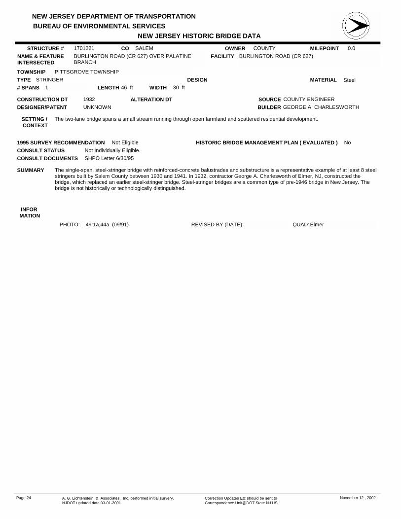
MILEPOINT 0.0CO SALEMNAME & FEATURE INTERSECTED
BURLINGTON ROAD (CR 627) OVER PALATINE BRANCH
FACILITY BURLINGTON ROAD (CR 627)
TOWNSHIP PITTSGROVE TOWNSHIP
OWNER COUNTY
CONSTRUCTION DT 1932 SOURCE COUNTY ENGINEER
MATERIAL SteelTYPE STRINGERLENGTH 46 ft WIDTH 30 ft# SPANS 1
DESIGNER/PATENT UNKNOWN
SETTING / CONTEXT
The two-lane bridge spans a small stream running through open farmland and scattered residential development.
1995 SURVEY RECOMMENDATION Not Eligible
PHOTO: 49:1a,44a (09/91) REVISED BY (DATE):
DESIGN
BUILDER GEORGE A. CHARLESWORTH
CONSULT STATUS Not Individually Eligible.
QUAD: Elmer
SUMMARY The single-span, steel-stringer bridge with reinforced-concrete balustrades and substructure is a representative example of at least 8 steel stringers built by Salem County between 1930 and 1941. In 1932, contractor George A. Charlesworth of Elmer, NJ, constructed the bridge, which replaced an earlier steel-stringer bridge. Steel-stringer bridges are a common type of pre-1946 bridge in New Jersey. The bridge is not historically or technologically distinguished.
STRUCTURE # 1701221
ALTERATION DT
INFOR MATION
CONSULT DOCUMENTS SHPO Letter 6/30/95
HISTORIC BRIDGE MANAGEMENT PLAN ( EVALUATED ) No
Page 24 A. G. Lichtenstein & Associates, Inc. performed initial survery. NJDOT updated data 03-01-2001.
Correction Updates Etc should be sent to [email protected]
November 12 , 2002
NEW JERSEY DEPARTMENT OF TRANSPORTATION
NEW JERSEY HISTORIC BRIDGE DATABUREAU OF ENVIRONMENTAL SERVICES
MILEPOINT 0.0CO SALEMNAME & FEATURE INTERSECTED
CENTERTON BRIDGE (CR 540 & CR 553) OVER MUDDY RUN
FACILITY CENTERTON BRIDGETON ROAD (CR 540 & CR 553)
TOWNSHIP PITTSGROVE TOWNSHIP
OWNER COUNTY
CONSTRUCTION DT 1944 SOURCE PLAQUE
MATERIAL Reinforced Concrete
TYPE T BEAMLENGTH 67 ft WIDTH 30 ft# SPANS 2
DESIGNER/PATENT UNKNOWN
SETTING / CONTEXT
The two-lane, two-span bridge crosses over Muddy Run just downstream from and to the east of Centerton Lake and Dam in eastern Salem County. Centerton is a busy crossroads with an old tavern (c. 1800-50). The northern lakeshore is a residential development (c. 1920-70).
1995 SURVEY RECOMMENDATION Not Eligible
PHOTO: 49:33a-34a (09/91) REVISED BY (DATE):
DESIGN
BUILDER UNKNOWN
CONSULT STATUS Not Individually Eligible.
QUAD: Elmer
SUMMARY The two-span T-beam bridge with reinforced-concrete balustrades and substructure is a representative example of at least 17 similar T-beam bridges built by Salem County between 1917 and 1944. The bridge replaced a New Jersey Bridge Co. steel truss (c. 1904). It is not historically or technologically significant.
STRUCTURE # 1701235
ALTERATION DT
INFOR MATION
CONSULT DOCUMENTS SHPO Letter 6/30/95
HISTORIC BRIDGE MANAGEMENT PLAN ( EVALUATED ) No
Page 25 A. G. Lichtenstein & Associates, Inc. performed initial survery. NJDOT updated data 03-01-2001.
Correction Updates Etc should be sent to [email protected]
November 12 , 2002
NEW JERSEY DEPARTMENT OF TRANSPORTATION
NEW JERSEY HISTORIC BRIDGE DATABUREAU OF ENVIRONMENTAL SERVICES
MILEPOINT 0.0CO SALEMNAME & FEATURE INTERSECTED
WILLOW GROVE-DEERFIELD ROAD OVER MUDDY RUN
FACILITY WILLOW GROVE DEERFIELD ROAD (CR 690)
TOWNSHIP PITTSGROVE TOWNSHIP
OWNER COUNTY
CONSTRUCTION DT 1939 SOURCE COUNTY ENGINEER
MATERIAL Reinforced Concrete
TYPE T BEAMLENGTH 31 ft WIDTH 31.3 ft# SPANS 1
DESIGNER/PATENT UNKNOWN
SETTING / CONTEXT
Built into the upstream side of the two-lane bridge are wooden waste gates supported by concrete columns and beams. The gates create a small lake surrounded by summer cottages (c. 1920-90). The nearby area is predominately rural with fields, wooded lots, and residential developments. The structural association of bridges and dams is frequent in South Jersey.
1995 SURVEY RECOMMENDATION Not Eligible
PHOTO: 49:35a-37a (09/91) REVISED BY (DATE):
DESIGN
BUILDER UNKNOWN
CONSULT STATUS Not Individually Eligible.
QUAD: Elmer
SUMMARY The T-beam with reinforced-concrete balustrades and substructure is a representative example of at least 17 similar T-beam bridges built by Salem County between 1917 and 1944. The bridge replaced an earlier wood-stringer bridge. The T-beam bridge design enjoyed a period of popularity from the mid-1910s to the 1930s. The bridge is not historically or technologically significant.
STRUCTURE # 1701238
ALTERATION DT
INFOR MATION
CONSULT DOCUMENTS SHPO Letter 6/30/95
HISTORIC BRIDGE MANAGEMENT PLAN ( EVALUATED ) No
Page 26 A. G. Lichtenstein & Associates, Inc. performed initial survery. NJDOT updated data 03-01-2001.
Correction Updates Etc should be sent to [email protected]
November 12 , 2002

NEW JERSEY DEPARTMENT OF TRANSPORTATION
NEW JERSEY HISTORIC BRIDGE DATABUREAU OF ENVIRONMENTAL SERVICES
MILEPOINT 0.0CO SALEMNAME & FEATURE INTERSECTED
PALATINE-HUSTED STATION ROAD OVER INDIAN RUN
FACILITY PALATINE-HUSTED STATION ROAD (CR 677)
TOWNSHIP PITTSGROVE TOWNSHIP
OWNER COUNTY
CONSTRUCTION DT 1928 SOURCE COUNTY ENGINEER
MATERIAL Reinforced Concrete
TYPE T BEAMLENGTH 35 ft WIDTH 20.1 ft# SPANS 1
DESIGNER/PATENT UNKNOWN
SETTING / CONTEXT
The two-lane bridge spans a small creek in a wooded area about 1/4 mile south of a farmhouse (c. 1900).
1995 SURVEY RECOMMENDATION Not Eligible
PHOTO: 49:42a-43a (09/91) REVISED BY (DATE):
DESIGN
BUILDER GEORGE A. CHARLESWORTH
CONSULT STATUS Not Individually Eligible.
QUAD: Elmer
SUMMARY The single-span T-beam bridge with reinforced-concrete balustrades and substructure is a representative example of at least 17 similar T-beam bridges built by Salem County from 1917 to 1944. Contractor George A. Charlesworth of Elmer, NJ, constructed the T-beam, which replaced a wood stringer bridge. The bridge is not historically or technologically significant.
STRUCTURE # 1701243
ALTERATION DT
INFOR MATION
CONSULT DOCUMENTS SHPO Letter 6/30/95
HISTORIC BRIDGE MANAGEMENT PLAN ( EVALUATED ) No
Page 27 A. G. Lichtenstein & Associates, Inc. performed initial survery. NJDOT updated data 03-01-2001.
Correction Updates Etc should be sent to [email protected]
November 12 , 2002
NEW JERSEY DEPARTMENT OF TRANSPORTATION
NEW JERSEY HISTORIC BRIDGE DATABUREAU OF ENVIRONMENTAL SERVICES
MILEPOINT 0.0CO SALEMNAME & FEATURE INTERSECTED
STATE PARK-WILLOW GROVE ROAD OVER MUDDY RUN
FACILITY STATE PARK WILLOW GROVE ROAD (CR 645)
TOWNSHIP PITTSGROVE TOWNSHIP
OWNER COUNTY
CONSTRUCTION DT 1941 SOURCE PLAQUE
MATERIAL Reinforced Concrete
TYPE SLABLENGTH 54 ft WIDTH 30 ft# SPANS 2
DESIGNER/PATENT UNKNOWN
SETTING / CONTEXT
The two-lane, two-span bridge is located within the boundaries of wooded Parvin State Park (c. 1933-41). It is structurally associated with the circular spillway and dam that creates 4/5 mile-long Parvin Lake, the park's central recreational feature. On the lake's north shore is a bath house and beach, and on the south nature areas, log cabins, and campgrounds. The early south Jersey park was developed as a CCC project.
1995 SURVEY RECOMMENDATION Not Eligible
PHOTO: 49:30a-32a (09/91) REVISED BY (DATE):
DESIGN
BUILDER CIVILIAN CONSERVATION CORPS
CONSULT STATUS Not Individually Eligible. Potential Parvin Lake Park Historic District. Contributing.
QUAD: Elmer
SUMMARY The 2-span concrete slab bridge with concrete balustrades and substructure ranks as one of the most architectonic of its type in the region. The well-proportioned upstream wing walls with parapets set off the bridge from the circular concrete spillway/dam. Earlier and more historically distinguished examples of concrete-slab bridges exist in the state (e.g. 0809L02). Although not individually significant, the bridge is locally significant as a contributing resource to a potential historic district: the CCC-developed park.
STRUCTURE # 1701252
ALTERATION DT
INFOR MATION
SOURCES:Condit, Carl W. American Build Art: The Twentieth Century. New York: Oxford University Press, 1961.Salem County Board of Freeholders. Minute Books. July 11, 1923, and August 13, 1941.Salem County Engineer. Bridge Cards. #1252.Shuck, Albert C., et. al. "A Story of Salem County." Typescript. Salem City Public Library. 1938.
PHYSICAL DESCRIPTION The 54'-long, two-span concrete-slab bridge with concrete balustrades, concrete abutments, and concrete cutwater pier survives in a good state of preservation. The large upstream wing walls have concrete parapets with horizontal scoring. The parapets meet the bridge's balustrades and form a continuous railing for pedestrians. Extending between the upstream wing walls is the semi-circular concrete spillway/dam that forms Parvin Lake.
HISTORICAL AND TECHNOLOGICAL SIGNIFICANCE The concrete slab bridge is one of the largest and most distinguished of its type in the region. It is a central feature of Parvin State Park, one of the first state parks in South Jersey. It is also an excellent example of a New Deal public works project. The bridge is well-proportioned to provide bridge traffic with a view of the water cascading over the semi-circular spillway/dam.
A bridge has stood at the site since at least the mid-19th century. In 1867 Lemuel Parvin bought the surrounding property and constructed a saw mill, dam, and pond. In 1923 the county replaced the preexisting wood-stringer bridge with a concrete T-beam bridge. At the same time they built a concrete dam/spillway. In the 1920s the bridge was known as Ackley's Mill Pond Bridge after the then current owner of the saw mill. No physical above-ground evidence of the saw mill and its associated structures remains.
In 1933 the mill site and pond were acquired by the New Jersey Department of Conservation and Development as a Civilian Conservation Corps (CCC) camp and state park. The CCC was a New Deal work-relief program for young men. By June 1933, the CCC had 1,300 camps nation-wide and employed 300,000 men. The CCC did much to improve national and state parks. At Parvin State Park the Corps cleared picnic grounds, built cabins and a bath house, constructed roads and bridges, and dredged the pond. Most of these improvements still exist within the park. In the flood of September 1940, the 1923 T-beam bridge and spillway were destroyed. CCC workers built the new two-span concrete-slab bridge with materials provided by the county. The bridge was completed in August 1941.
CONSULT DOCUMENTS SHPO Letter 11/22/95
HISTORIC BRIDGE MANAGEMENT PLAN ( EVALUATED ) Yes
Page 28 A. G. Lichtenstein & Associates, Inc. performed initial survery. NJDOT updated data 03-01-2001.
Correction Updates Etc should be sent to [email protected]
November 12 , 2002

NEW JERSEY DEPARTMENT OF TRANSPORTATION
NEW JERSEY HISTORIC BRIDGE DATABUREAU OF ENVIRONMENTAL SERVICES
MILEPOINT 0.0CO SALEMNAME & FEATURE INTERSECTED
GERSHEL AVE (CR 638) OVER MUDDY RUN FACILITY GERSHEL AVENUE (CR 638)
TOWNSHIP PITTSGROVE TOWNSHIP
OWNER COUNTY
CONSTRUCTION DT 1930 SOURCE COUNTY ENGINEER
MATERIAL SteelTYPE STRINGERLENGTH 122 ft WIDTH 30 ft# SPANS 3
DESIGNER/PATENT UNKNOWN
SETTING / CONTEXT
The two-lane bridge spans a wide but shallow stream in a forested section of the DEP's Union Lake Wildlife Management Area located near the Maurice River in eastern Salem County. The surrounding area is undeveloped.
1995 SURVEY RECOMMENDATION Not Eligible
PHOTO: 49:25a-26a (09/91) REVISED BY (DATE):
DESIGN HYBRID
BUILDER CAMPBELL AND SON
CONSULT STATUS Not Individually Eligible.
QUAD: Millville
SUMMARY The unaltered three-span bridge with reinforced-concrete substructure has T-beam approach spans and a steel-stringer center span with encased fascia stringers. The approaches have paneled concrete parapets and the center span has concrete balustrades. T-beams and steel-stringers are two common bridge types and account for 44 of the 56 existing pre-1946 bridges in Salem County. The bridge is not historically or technologically distinguished.
STRUCTURE # 1701274
ALTERATION DT
INFOR MATION
CONSULT DOCUMENTS SHPO Letter 6/30/95
HISTORIC BRIDGE MANAGEMENT PLAN ( EVALUATED ) No
Page 29 A. G. Lichtenstein & Associates, Inc. performed initial survery. NJDOT updated data 03-01-2001.
Correction Updates Etc should be sent to [email protected]
November 12 , 2002
NEW JERSEY DEPARTMENT OF TRANSPORTATION
NEW JERSEY HISTORIC BRIDGE DATABUREAU OF ENVIRONMENTAL SERVICES
MILEPOINT 0.0CO SALEMNAME & FEATURE INTERSECTED
LOWER ALLOWAYS NECK ROAD OVER LONG BRANCH CREEK
FACILITY LOWER ALLOWAYS NECK ROAD (CR 658)
TOWNSHIP LOWER ALLOWAYS CREEK TOWNSHIP
OWNER COUNTY
CONSTRUCTION DT 1919 SOURCE COUNTY ENGINEER
MATERIAL Reinforced Concrete
TYPE T BEAMLENGTH 26 ft WIDTH 30 ft# SPANS 1
DESIGNER/PATENT UNKNOWN
SETTING / CONTEXT
The two-lane bridge spans a narrow cut through an undeveloped marshy wetlands near the Salem Nuclear Power Plant entrance. About 2/5 mile to the east is the small village of Hancock's Bridge (c.1750-1900) which includes the National Register-listed Hancock House (c.1750). The bridge is not associated or contiguous with the historic property.
1995 SURVEY RECOMMENDATION Not Eligible
PHOTO: 46:44 (09/91) REVISED BY (DATE):
DESIGN
BUILDER WILLIAM H. SHOUGH
CONSULT STATUS Not Individually Eligible.
QUAD: Salem
SUMMARY The single-span T-beam bridge with reinforced-concrete substructure and pipe railing is an older example of at least 17 similar T-beam bridges built by Salem County from 1917 to 1944. Builder William H. Shough of Alloway constructed at least six T-beam bridges in the county. The bridge is not historically or technologically significant.
STRUCTURE # 1701320
ALTERATION DT
INFOR MATION
CONSULT DOCUMENTS SHPO Letter 6/30/95
HISTORIC BRIDGE MANAGEMENT PLAN ( EVALUATED ) No
Page 30 A. G. Lichtenstein & Associates, Inc. performed initial survery. NJDOT updated data 03-01-2001.
Correction Updates Etc should be sent to [email protected]
November 12 , 2002
NEW JERSEY DEPARTMENT OF TRANSPORTATION
NEW JERSEY HISTORIC BRIDGE DATABUREAU OF ENVIRONMENTAL SERVICES
MILEPOINT 0.0CO SALEMNAME & FEATURE INTERSECTED
NEW BRIDGE (CR 623) OVER ALLOWAYS CREEK FACILITY NEW BRIDGE ROAD (CR 623)
TOWNSHIP LOWER ALLOWAYS CREEK TOWNSHIP
OWNER COUNTY
CONSTRUCTION DT 1905 SOURCE COUNTY ENGINEER
MATERIAL SteelTYPE SWING SPANLENGTH 151 ft WIDTH 14.8 ft# SPANS 2
DESIGNER/PATENT UNKNOWN
SETTING / CONTEXT
The single-lane bridge spans a tidal estuary in an undeveloped wetlands near the Delaware Bay. The surrounding area is rural with fields and scattered residences.
1995 SURVEY RECOMMENDATION Eligible
DESIGN CENTER BEARING
BUILDER NEW JERSEY BRIDGE COMPANY
CONSULT STATUS Individually Eligible.
SUMMARY The bridge is a center-bearing, steel-truss swing span with modified Warren pony truss approach span. The bridge was hand operated and the mechanism is in place, although the bridge has not been opened since the mid-1960s. It has ornamental finials, lattice work, and plaque on the tower. The bridge is the best example of its type in the southern part of the state. It is one of a small handful of documented surviving NJ Bridge Co. bridges in the United States.
STRUCTURE # 1701399
ALTERATION DT 1976
INFOR MATION
SOURCES:Hool, George A. and W. S. Kinne, eds. Movable and Long Span Bridges. New York: McGraw-Hill, 1923.Manasquan Chamber of Commerce. Manasquan, New Jersey. 1962.Manasquan Historical Society. "New Jersey Bridge Company File."Salem County Board of Chosen Freeholders. Minute Books. 1905.Salem County Engineer. Plans and Bridge Cards. #1399.Salem Sunbeam. Aug. 11, Aug. 16, and Sept. 20, 1905.
Physical Description: The bridge is a 110'-long, single-lane, wood-decked, center-bearing, steel through truss swing span with a 37'-long, 3-panel, riveted Warren pony truss span on the north side. The main span is a 9-panel truss with a central tower. At the first panel it is 8'-deep, and at the tower it is 22'-deep. The lower chord consists of angles with lacing, and the upper chord of channels with lacing and a cover plate. All connections are riveted. The verticals are laced angles or channels, and the diagonals are channels with battens. The central tower has latticed portals, lateral tie rods, and two of four original urn-shaped finials. Plaques on the tower portals read "1905. Built by New Jersey Bridge Co., Manasquan NJ."
The swing span is inoperable, but the operating mechanism remains extant. It is a center-bearing type, hand-powered by a crank attachment inset in the deck. The crank turned a pinion gear against a circular rack. The rack is mounted to the top of the center pier. The bridge was designed to open in either direction, and turns upon a center bearing. A box-shaped system of four girder with four balance wheels supported and balanced the bridge on the center pier when the bridge was in the open position. The south end of the bridge rests on steel rollers with axles perpendicular to the length of the bridge. They were hand operated by levers and designed to lift the bridge in the closed position, lock it in place, and provide it with a footing on the abutment. The swing span has timber pile fenders. It provided a 42'-channel to river navigation, and last opened in the mid-1960s.
Numerous alterations have been made to the substructure and the approach span, but none seriously compromise the bridge's overall integrity of design. The original piers and abutments were masonry. In 1925 the center pier was widened and reinforced with concrete. In 1942 the south abutment was rebuilt with concrete, and in 1957 the abutments were raised by approximately 12 inches. In 1966 the northern pier and abutment were reinforced with concrete. In 1976, following a vehicular accident, an end post and portion of the lower chord of the west side of the pony truss were replaced and repairs made to the panel points. A vertical on the east side of swing span was replaced, and the lattice railings were removed and beam guard rails added. In 1979 the approach span was strengthened with the addition of longitudinal steel stringers that effectively relieved the pony trusses of load bearing responsibility. In 1991 the single-lane bridge was closed to vehicular traffic due to safety concerns and structural inadequacies.
Historical and Technological Significance: The bridge is one of the few documented surviving examples of a bridge constructed by the New Jersey Bridge Company of Manasquan. Although never recognized as a major national bridge builder, the company was a significant in-state manufacturer of highway bridges. The swing span over Alloways Creek is a good representative example of a popular 20th-century movable span bridge technology that is becoming increasingly rare. It retains integrity of design and of setting.
A bridge has spanned Alloways Creek at the site of New Bridge since the early-19th century. In 1905 the Salem County Board of Freeholders decided to replace the worn-out wooden draw bridge with a new steel swing span. They drew specifications for the new bridge and advertised for bids. At a price of $10,200, the NJ Bridge Co. was the lowest bidder of seven companies.
The NJ Bridge Co. operated from 1890 to 1907. The company was started by two gentlemen from Canton, Ohio, Mr. Wyckoop and Mr. Braly. The built a 300'-deep, 100'-wide shop in Manasquan on Atlantic Avenue, adjacent the railroad tracks. At the height of their operation they employed 15 to 20 draftsmen and 100 men in the fabricating shop. A local history claims that the company "was the largest individual manufacturing facility ever to have existed in Manasquan." In 1904-1907 the company ran into financial difficulties after securing the contract to build a large swing span, Long Bridge over the Fore River, in Portland, Maine. Unable to meet its obligations and material deliveries, the company went out of business in 1907. The company went into bankruptcy at the end of an era of small, regional, independent, bridge manufacturers. The Manasquan Historical Society owns a series of photographs illustrating the company shops. No
CONSULT DOCUMENTS SHPO Letter 6/30/95
HISTORIC BRIDGE MANAGEMENT PLAN ( EVALUATED ) No
Page 31 A. G. Lichtenstein & Associates, Inc. performed initial survery. NJDOT updated data 03-01-2001.
Correction Updates Etc should be sent to [email protected]
November 12 , 2002

NEW JERSEY DEPARTMENT OF TRANSPORTATION
NEW JERSEY HISTORIC BRIDGE DATABUREAU OF ENVIRONMENTAL SERVICES
PHOTO: 46:4-8 (09/91) REVISED BY (DATE): QUAD: Salem
known company records survive.
According to a local history, many of the bridges built by the NJ Bridge Co. were erected in Middlesex and Monmouth Counties. The company had some national contracts; in addition to the Portland Bridge, which has been demolished, a Pratt truss has been identified in Grand Rapids, Michigan. It too is scheduled for replacement. In Salem County a slightly larger, less well-preserved, and similar movable bridge spans Oldmans Creek near Pedricktown (1700199). According to local records, in 1906 the New Jersey-West Virginia Bridge Co. constructed the Pedricktown Bridge based upon the same specifications prepared for the swing span at Alloways Creek. The relationship of the NJ Bridge Company to the NJ-WV Bridge Company is not known, except that it seems a reasonable assumption that the latter was a merger or buy-out intended to save the former from bankruptcy.
Boundary Description and Justification: Although the unspoiled setting contributes to the character of the well-preserved bridge, it is the structure itself that is evaluated as significant. The boundary is thus limited to the bridge, substructure and superstructure, of the approach span and the movable span themselves.
Page 32 A. G. Lichtenstein & Associates, Inc. performed initial survery. NJDOT updated data 03-01-2001.
Correction Updates Etc should be sent to [email protected]
November 12 , 2002

NEW JERSEY DEPARTMENT OF TRANSPORTATION
NEW JERSEY HISTORIC BRIDGE DATABUREAU OF ENVIRONMENTAL SERVICES
MILEPOINT 8.56CO SALEMNAME & FEATURE INTERSECTED
US 40 OVER SALEM CREEK FACILITY US 40
TOWNSHIP PILESGROVE TOWNSHIP
OWNER NJDOT
CONSTRUCTION DT 1919 SOURCE NJDOT
MATERIAL SteelTYPE STRINGERLENGTH 57 ft WIDTH 30.3 ft# SPANS 2
DESIGNER/PATENT H. B. KEASBEY, CO. ENG.
SETTING / CONTEXT
The two-lane bridge spans tree-lined Salem Creek near Richmans Dairy store (c. 1930) outside of Woodstown. The bridge is about 1/5 mile west of the busy commercial intersection of US 40 and CR 620. The area to the east is residential (c.1950).
1995 SURVEY RECOMMENDATION Not Eligible
PHOTO: 47:20-21 (09/91) REVISED BY (DATE):
DESIGN ENCASED
BUILDER UNKNOWN
CONSULT STATUS Not Individually Eligible.
QUAD: Woodstown
SUMMARY The two-span, steel-stringer bridge with reinforced-concrete substructure has been extensively altered (c.1990). Beam guide rails and concrete barrier curbs have been added to the bridge. Concrete encasing has been removed from the fascia stringers but remains on the interior stringers. The original concrete balustrades have been removed. The county-built bridge was transferred to the state highway system in the 1950s. It is not historically or technologically distinguished.
STRUCTURE # 1702154
ALTERATION DT 1990
INFOR MATION
CONSULT DOCUMENTS SHPO Letter 6/30/95
HISTORIC BRIDGE MANAGEMENT PLAN ( EVALUATED ) No
Page 33 A. G. Lichtenstein & Associates, Inc. performed initial survery. NJDOT updated data 03-01-2001.
Correction Updates Etc should be sent to [email protected]
November 12 , 2002

NEW JERSEY DEPARTMENT OF TRANSPORTATION
NEW JERSEY HISTORIC BRIDGE DATABUREAU OF ENVIRONMENTAL SERVICES
MILEPOINT 13.57CO SALEMNAME & FEATURE INTERSECTED
US 40 OVER BRANCH OF SALEM CREEK FACILITY US 40
TOWNSHIP PILESGROVE TOWNSHIP
OWNER NJDOT
CONSTRUCTION DT 1929 SOURCE INSCRIPTION
MATERIAL Reinforced Concrete
TYPE STRINGERLENGTH 24 ft WIDTH 40 ft# SPANS 1
DESIGNER/PATENT NJ STATE HWY DEPT BRIDGE DIV
SETTING / CONTEXT
The two-lane bridge spans a small creek adjacent to a cow pasture and dairy farm (c. 1900) about two miles east of Woodstown. The surrounding area is rural with fields, wooded lots, and scattered 19th and 20th-century residences.
1995 SURVEY RECOMMENDATION Not Eligible
PHOTO: 48:13-14 (09/91) REVISED BY (DATE):
DESIGN ENCASED
BUILDER
CONSULT STATUS Not Individually Eligible.
QUAD: Woodstown
SUMMARY The single-span encased stringer bridge with concrete balustrades and substructure is representative of many bridges built by the NJ State Highway Department in the 1920s and 1930s. Markers indicate the original route designation of the bridge was "State Highway Route 48." Beam guide rails have been added. The bridge is not historically or technologically distinguished.
STRUCTURE # 1703152
ALTERATION DT
INFOR MATION
CONSULT DOCUMENTS SHPO Letter 6/30/95
HISTORIC BRIDGE MANAGEMENT PLAN ( EVALUATED ) No
Page 34 A. G. Lichtenstein & Associates, Inc. performed initial survery. NJDOT updated data 03-01-2001.
Correction Updates Etc should be sent to [email protected]
November 12 , 2002
NEW JERSEY DEPARTMENT OF TRANSPORTATION
NEW JERSEY HISTORIC BRIDGE DATABUREAU OF ENVIRONMENTAL SERVICES
MILEPOINT 20.27CO SALEMNAME & FEATURE INTERSECTED
US 40 OVER ELMER LAKE FACILITY US 40
TOWNSHIP PITTSGROVE TOWNSHIP
OWNER NJDOT
CONSTRUCTION DT 1929 SOURCE INSCRIPTION
MATERIAL SteelTYPE STRINGERLENGTH 38 ft WIDTH 40 ft# SPANS 1
DESIGNER/PATENT NJ STATE HWY DEPT BRIDGE DIV
SETTING / CONTEXT
The two-lane bridge crosses Elmer Lake just to the east of the small village of Elmer (c. 1850-1950). Next to the bridge is a municipal baseball park and playground. Small businesses, gas stations, and a diner (c. 1950) line the stretch of US 40. The bridge approaches are earthen causeways built out into Elmer Lake.
1995 SURVEY RECOMMENDATION Not Eligible
PHOTO: 49:18a-19a (09/91) REVISED BY (DATE):
DESIGN ENCASED
BUILDER
CONSULT STATUS Not Individually Eligible.
QUAD: Elmer
SUMMARY The single-span, encased steel-stringer bridge with reinforced-concrete balustrades and substructure is a representative example of many bridges designed by the State Highway Department in the 1920s and 1930s. Markers indicate the original route designation of the bridge was "State Highway Route 48" before the US 40 designation. Beam guide rails have been added. The bridge is not historically or technologically distinguished.
STRUCTURE # 1703156
ALTERATION DT
INFOR MATION
CONSULT DOCUMENTS SHPO Letter 6/30/95
HISTORIC BRIDGE MANAGEMENT PLAN ( EVALUATED ) No
Page 35 A. G. Lichtenstein & Associates, Inc. performed initial survery. NJDOT updated data 03-01-2001.
Correction Updates Etc should be sent to [email protected]
November 12 , 2002

NEW JERSEY DEPARTMENT OF TRANSPORTATION
NEW JERSEY HISTORIC BRIDGE DATABUREAU OF ENVIRONMENTAL SERVICES
MILEPOINT 0.0CO SALEMNAME & FEATURE INTERSECTED
POINTERS-AUBURN ROAD (CR 646) OVER SALEM CREEK
FACILITY POINTERS AUBURN ROAD (CR 646)
TOWNSHIP PILESGROVE TOWNSHIP
OWNER COUNTY
CONSTRUCTION DT 1931 SOURCE COUNTY ENGINEER
MATERIAL SteelTYPE DECK PLATE GIRDERLENGTH 225 ft WIDTH 29.8 ft# SPANS 3
DESIGNER/PATENT UNKNOWN
SETTING / CONTEXT
The two-lane, three-span steel deck girder crosses Salem Creek along a tree-lined stretch of county road. A small farm (c. 1900) sits next to the bridge, and the surrounding area is predominately rural with farmers' fields, wooded lots, and scattered houses. The bridge is popular with fishermen.
1995 SURVEY RECOMMENDATION Not Eligible
PHOTO: 47:18-19 (09/91) REVISED BY (DATE):
DESIGN ENCASED
BUILDER CAMPBELL AND SON
CONSULT STATUS Not Individually Eligible.
QUAD: Penns Grove
SUMMARY The three-span, deck plate girder bridge with floor beams and cantilevered sidewalks has a reinforced-concrete substructure. The pipe railings on the center span replaced the concrete balustrades lost as a result of a vehicular accident. In 1931 contractor Campbell and Son of Bridgeton constructed the bridge, which replaced an earlier movable span. The bridge is a representative example of the deck girder type. It is not historically or technologically distinguished.
STRUCTURE # 1704000
ALTERATION DT
INFOR MATION
CONSULT DOCUMENTS SHPO Letter 6/30/95
HISTORIC BRIDGE MANAGEMENT PLAN ( EVALUATED ) No
Page 36 A. G. Lichtenstein & Associates, Inc. performed initial survery. NJDOT updated data 03-01-2001.
Correction Updates Etc should be sent to [email protected]
November 12 , 2002

NEW JERSEY DEPARTMENT OF TRANSPORTATION
NEW JERSEY HISTORIC BRIDGE DATABUREAU OF ENVIRONMENTAL SERVICES
MILEPOINT 0.0CO SALEMNAME & FEATURE INTERSECTED
LOCUSON ROAD OVER BRANCH OF SALEM CREEK FACILITY LOCUSON ROAD (RENTER ROAD)
TOWNSHIP PILESGROVE TOWNSHIP
OWNER COUNTY
CONSTRUCTION DT 1924 SOURCE COUNTY ENGINEER
MATERIAL Reinforced Concrete
TYPE T BEAMLENGTH 33 ft WIDTH 19.8 ft# SPANS 1
DESIGNER/PATENT UNKNOWN
SETTING / CONTEXT
The two-lane bridge crosses a small creek on a dead-end road about 300 yards from a horse farm with numerous outbuildings (c. 1870-1950). The creek flows through pasture land.
1995 SURVEY RECOMMENDATION Not Eligible
PHOTO: 48:15 (09/91) REVISED BY (DATE):
DESIGN
BUILDER WILLIAM H. SHOUGH
CONSULT STATUS Not Individually Eligible.
QUAD: Woodstown
SUMMARY The single-span T-beam bridge with reinforced-concrete balustrades and substructure is a representative example of at least 17 similar T-beam bridges built by Salem County from 1917 to 1944. Builder William H. Shough of Alloway, NJ, constructed at least six T-beams in the county. The bridge is not historically or technologically significant.
STRUCTURE # 1704136
ALTERATION DT
INFOR MATION
CONSULT DOCUMENTS SHPO Letter 6/30/95
HISTORIC BRIDGE MANAGEMENT PLAN ( EVALUATED ) No
Page 37 A. G. Lichtenstein & Associates, Inc. performed initial survery. NJDOT updated data 03-01-2001.
Correction Updates Etc should be sent to [email protected]
November 12 , 2002

NEW JERSEY DEPARTMENT OF TRANSPORTATION
NEW JERSEY HISTORIC BRIDGE DATABUREAU OF ENVIRONMENTAL SERVICES
MILEPOINT 0.0CO SALEMNAME & FEATURE INTERSECTED
AVIS MILL ROAD OVER SALEM CREEK FACILITY AVIS MILL ROAD
TOWNSHIP PILESGROVE TOWNSHIP
OWNER COUNTY
CONSTRUCTION DT 1920 SOURCE COUNTY ENGINEER
MATERIAL SteelTYPE STRINGERLENGTH 36 ft WIDTH 29.2 ft# SPANS 1
DESIGNER/PATENT UNKNOWN
SETTING / CONTEXT
Avis Mill Road sits atop the earthen dam that creates Avis Mill Pond. The two-lane bridge crosses a spillway at the dam's southern end while another one-lane bridge (1704139) crosses another spillway at the dam's northern end. The lake and dam are part of the YMCA's Camp Carney (c. 1950). A semi-circular concrete spillway/dam extends between the bridge's abutments.
1995 SURVEY RECOMMENDATION Not Eligible
PHOTO: 48:16-17 (09/91) REVISED BY (DATE):
DESIGN
BUILDER UNKNOWN
CONSULT STATUS Not Individually Eligible.
QUAD: Woodstown
SUMMARY The single-span, encased steel-stringer bridge with concrete substructure has been significantly altered. In 1951, when the dam was built, the county removed the original flood gates built into the bridge's upstream side. In 1964 the bridge was widened with a 16'-wide concrete slab addition on the downstream side. At the same time the original concrete balustrades were replaced with concrete barrier railings. The bridge is not historically or technologically distinguished.
STRUCTURE # 1704138
ALTERATION DT 1951
INFOR MATION
CONSULT DOCUMENTS SHPO Letter 6/30/95
HISTORIC BRIDGE MANAGEMENT PLAN ( EVALUATED ) No
Page 38 A. G. Lichtenstein & Associates, Inc. performed initial survery. NJDOT updated data 03-01-2001.
Correction Updates Etc should be sent to [email protected]
November 12 , 2002

NEW JERSEY DEPARTMENT OF TRANSPORTATION
NEW JERSEY HISTORIC BRIDGE DATABUREAU OF ENVIRONMENTAL SERVICES
MILEPOINT 0.0CO SALEMNAME & FEATURE INTERSECTED
AVIS MILL ROAD OVER SALEM CREEK FACILITY AVIS MILL ROAD
TOWNSHIP PILESGROVE TOWNSHIP
OWNER COUNTY
CONSTRUCTION DT 1917 SOURCE COUNTY ENGINEER
MATERIAL Reinforced Concrete
TYPE T BEAMLENGTH 27 ft WIDTH 18.3 ft# SPANS 1
DESIGNER/PATENT UNKNOWN
SETTING / CONTEXT
Avis Mill Road runs atop the earthen dam that creates Avis Mill Pond. The single-lane bridge spans a spillway at the northern end of the dam while another two-lane bridge (1704138) spans a spillway at the southern end. The pond and dam are part of the YMCA's Camp Carney (c. 1950). A semi-circular concrete dam with metal sheathing extends from the bridge abutments.
1995 SURVEY RECOMMENDATION Not Eligible
PHOTO: 48:18-19 (09/91) REVISED BY (DATE):
DESIGN
BUILDER UNKNOWN
CONSULT STATUS Not Individually Eligible.
QUAD: Woodstown
SUMMARY The single-span T-beam bridge with reinforced-concrete substructure and concrete balustrades has been significantly altered. In 1951, when the circular spillway was built, the original flood gates on the upstream side were removed, and an I-beam column and stringer were added for support. Thus while one of the oldest of at least 17 T-beams in the county, the bridge lacks integrity of design. The bridge is not historically or technologically distinguished.
STRUCTURE # 1704139
ALTERATION DT 1951
INFOR MATION
CONSULT DOCUMENTS SHPO Letter 6/30/95
HISTORIC BRIDGE MANAGEMENT PLAN ( EVALUATED ) No
Page 39 A. G. Lichtenstein & Associates, Inc. performed initial survery. NJDOT updated data 03-01-2001.
Correction Updates Etc should be sent to [email protected]
November 12 , 2002

NEW JERSEY DEPARTMENT OF TRANSPORTATION
NEW JERSEY HISTORIC BRIDGE DATABUREAU OF ENVIRONMENTAL SERVICES
MILEPOINT 0.4CO SALEMNAME & FEATURE INTERSECTED
NJ 45 (MARKET STREET) OVER FENWICK CREEK FACILITY NJ 45 (MARKET STREET)
TOWNSHIP SALEM CITY
OWNER NJDOT
CONSTRUCTION DT 1923 SOURCE INSCRIPTION
MATERIAL SteelTYPE STRINGERLENGTH 75 ft WIDTH 30.8 ft# SPANS 2
DESIGNER/PATENT NJ STATE HWY DEPT BRIDGE DIV
SETTING / CONTEXT
The two-lane bridge spans a wide tidal pond on the outskirts of Salem City. The bridge's south approach is included in the boundaries of the Market Street Historic District (c. 1720-1900). Near the bridge are many significant late-18th and early-19th century homes. To the north is a modern office building owned by the New Jersey Department of Motor Vehicles. The Fenwick Bridge replaced the last covered bridge in Salem County.
1995 SURVEY RECOMMENDATION Not Eligible
PHOTO: 46:33-34 (09/91) REVISED BY (DATE):
DESIGN ENCASED
BUILDER
CONSULT STATUS Bridge was Not Individually Eligible.
QUAD: Salem
SUMMARY The two-span, encased, steel-stringer bridge with reinforced-concrete substructure has concrete balustrades on the two spans and parapets on the long approaches. The Fenwick Bridge is next to the Market Street Historic District, but is not part of the district. The span's construction date is not within the district's period of significance. The bridge is a representative example of a common bridge type in New Jersey. It is not historically or technologically significant.
STRUCTURE # 1704150
ALTERATION DT Demolished
INFOR MATION
CONSULT DOCUMENTS SHPO Finding 4/30/91
HISTORIC BRIDGE MANAGEMENT PLAN ( EVALUATED ) No
Page 40 A. G. Lichtenstein & Associates, Inc. performed initial survery. NJDOT updated data 03-01-2001.
Correction Updates Etc should be sent to [email protected]
November 12 , 2002

NEW JERSEY DEPARTMENT OF TRANSPORTATION
NEW JERSEY HISTORIC BRIDGE DATABUREAU OF ENVIRONMENTAL SERVICES
MILEPOINT 4.1CO SALEMNAME & FEATURE INTERSECTED
NJ 45 OVER MANNINGTON CREEK FACILITY NJ 45
TOWNSHIP MANNINGTON TOWNSHIP
OWNER NJDOT
CONSTRUCTION DT 1915 SOURCE COUNTY ENGINEER
MATERIAL SteelTYPE STRINGERLENGTH 22 ft WIDTH 30.7 ft# SPANS 1
DESIGNER/PATENT UNKNOWN
SETTING / CONTEXT
The two-lane bridge spans a creek in a wetlands. The surrounding area is predominately rural with scattered houses, cow pastures, and farmers' fields. The Jedik Allen House approximately 1/4-mile to the west on Mannington Hill has been determined to be ineligible for inclusion in the National Register (SHPO Meeting 5/8/91). The bridge has been found ineligible by the SHPO Office (Finding 4/30/91).
1995 SURVEY RECOMMENDATION Not Eligible
PHOTO: 47:14-15 (09/91) REVISED BY (DATE):
DESIGN
BUILDER WILLIAM H. SHOUGH
CONSULT STATUS Not Individually Eligible.
QUAD: Salem
SUMMARY The single-span, steel-stringer bridge has reinforced-concrete abutments and wing walls. Beam guide rails have been added. Builder William H. Shough of Alloway constructed at least six bridges in the county between 1915 and 1925. Steel-stringer bridges are a common pre-1946 bridge type in New Jersey. In Salem County alone, over 20 steel-stringer bridges were built between 1911 and 1941. The bridge is not historically or technologically distinguished.
STRUCTURE # 1704151
ALTERATION DT
INFOR MATION
CONSULT DOCUMENTS SHPO Finding 4/30/91
HISTORIC BRIDGE MANAGEMENT PLAN ( EVALUATED ) No
Page 41 A. G. Lichtenstein & Associates, Inc. performed initial survery. NJDOT updated data 03-01-2001.
Correction Updates Etc should be sent to [email protected]
November 12 , 2002

NEW JERSEY DEPARTMENT OF TRANSPORTATION
NEW JERSEY HISTORIC BRIDGE DATABUREAU OF ENVIRONMENTAL SERVICES
MILEPOINT 5.2CO SALEMNAME & FEATURE INTERSECTED
NJ 45 OVER CULLIERS RUN FACILITY NJ 45
TOWNSHIP MANNINGTON TOWNSHIP
OWNER NJDOT
CONSTRUCTION DT 1911 SOURCE NJDOT
MATERIAL SteelTYPE STRINGERLENGTH 23 ft WIDTH 30.1 ft# SPANS 1
DESIGNER/PATENT UNKNOWN
SETTING / CONTEXT
The two-lane bridge spans a small creek along a wooded stretch of state highway between Woodstown and Salem. The surrounding area is predominately rural with farmers' fields, wooded lots, and scattered residences (c. 1800-1990).
1995 SURVEY RECOMMENDATION Not Eligible
PHOTO: 47:12-13 (09/91) REVISED BY (DATE):
DESIGN JACK ARCH
BUILDER UNKNOWN
CONSULT STATUS Not Individually Eligible.
QUAD: Salem
SUMMARY The short steel-stringer bridge with reinforced-concrete substructure and encased fascia stringers has concrete jack arches springing from the lower flanges of the stringers. Beam guide rails have replaced the original pipe railing. The bridge is one of three similar bridges in the region built in 1911-12 (0808F01, 0807D03), and although jack arches in concrete are not common, they are not rare. This example is not historically or technologically distinguished.
STRUCTURE # 1704152
ALTERATION DT
INFOR MATION
CONSULT DOCUMENTS SHPO Finding 03/01/90
HISTORIC BRIDGE MANAGEMENT PLAN ( EVALUATED ) No
Page 42 A. G. Lichtenstein & Associates, Inc. performed initial survery. NJDOT updated data 03-01-2001.
Correction Updates Etc should be sent to [email protected]
November 12 , 2002

NEW JERSEY DEPARTMENT OF TRANSPORTATION
NEW JERSEY HISTORIC BRIDGE DATABUREAU OF ENVIRONMENTAL SERVICES
MILEPOINT 9.15CO SALEMNAME & FEATURE INTERSECTED
NJ 45 & US 40 OVER SALEM CREEK FACILITY NJ 45 & US 40 (WEST AVENUE)
TOWNSHIP WOODSTOWN BOROUGH
OWNER NJDOT
CONSTRUCTION DT 1940 SOURCE INSCRIPTION
MATERIAL SteelTYPE STRINGERLENGTH 56 ft WIDTH 40 ft# SPANS 1
DESIGNER/PATENT NJ STATE HWY DEPT BRIDGE DIV
SETTING / CONTEXT
The two-lane bridge spans Salem Creek on the eastern outskirts of Woodstown. The bridge is near a small municipal veterans' memorial park (c. 1950), a commercial strip, and an apartment housing complex (c. 1970).
1995 SURVEY RECOMMENDATION Not Eligible
PHOTO: 47:10-11 (09/91) REVISED BY (DATE):
DESIGN ENCASED
BUILDER
CONSULT STATUS Not Individually Eligible.
QUAD: Woodstown
SUMMARY The single-span, encased steel-stringer bridge with concrete balustrades and substructure is representative of many steel-stringer bridges designed by the State Highway Department between 1920 and 1940. The bridge is not technologically innovative or historically distinguished.
STRUCTURE # 1705150
ALTERATION DT
INFOR MATION
CONSULT DOCUMENTS SHPO Letter 6/30/95
HISTORIC BRIDGE MANAGEMENT PLAN ( EVALUATED ) No
Page 43 A. G. Lichtenstein & Associates, Inc. performed initial survery. NJDOT updated data 03-01-2001.
Correction Updates Etc should be sent to [email protected]
November 12 , 2002

NEW JERSEY DEPARTMENT OF TRANSPORTATION
NEW JERSEY HISTORIC BRIDGE DATABUREAU OF ENVIRONMENTAL SERVICES
MILEPOINT 10.1CO SALEMNAME & FEATURE INTERSECTED
NJ 45 OVER SALEM BRANCH OF CONRAIL FACILITY NJ 45 (MAIN STREET)
TOWNSHIP WOODSTOWN BOROUGH
OWNER NJDOT
CONSTRUCTION DT 1923 SOURCE NJDOT
MATERIAL SteelTYPE THRU GIRDERLENGTH 68 ft WIDTH 30.9 ft# SPANS 1
DESIGNER/PATENT PA-READING SEASHORE RAILROAD
SETTING / CONTEXT
The skewed, two-lane bridge crosses the Salem Branch of Conrail, the former Pennsylvania-Reading Seashore Lines Railroad. The bridge is located near the northern edge of town near a number of cold storage warehouses and a residential neighborhood (c. 1900-1920).
1995 SURVEY RECOMMENDATION Not Eligible
PHOTO: 47:3-4 (09/91) REVISED BY (DATE):
DESIGN
BUILDER
CONSULT STATUS Not Individually Eligible.
QUAD: Woodstown
SUMMARY The single-span, thru-girder bridge with floor beams has reinforced-concrete substructure and cantilevered sidewalks. The sidewalk has original steel railing on the west elevation, but a chain-link fence has replaced the railing on the east elevation. The bridge has been redecked, and the inside face of the girders is protected by modern concrete barriers. The bridge is a representative example of a popular type of overpass. It is not historically or technologically significant.
STRUCTURE # 1705151
ALTERATION DT
INFOR MATION
CONSULT DOCUMENTS SHPO Letter 6/30/95
HISTORIC BRIDGE MANAGEMENT PLAN ( EVALUATED ) No
Page 44 A. G. Lichtenstein & Associates, Inc. performed initial survery. NJDOT updated data 03-01-2001.
Correction Updates Etc should be sent to [email protected]
November 12 , 2002
NEW JERSEY DEPARTMENT OF TRANSPORTATION
NEW JERSEY HISTORIC BRIDGE DATABUREAU OF ENVIRONMENTAL SERVICES
MILEPOINT 12.45CO SALEMNAME & FEATURE INTERSECTED
NJ 45 OVER OLDMANS CREEK FACILITY NJ 45
TOWNSHIP PILESGROVE TOWNSHIP
OWNER NJDOT
CONSTRUCTION DT 1920 SOURCE INSCRIPTION
MATERIAL SteelTYPE STRINGERLENGTH 35 ft WIDTH 31 ft# SPANS 1
DESIGNER/PATENT NJ STATE HWY DEPT BRIDGE DIV
SETTING / CONTEXT
The two-lane bridge spans a small creek along a tree-lined section of state highway. The surrounding area is rural with scattered homes on large wooded lots, fields, and orchards. The bridge is located on the county line between Salem and Gloucester County.
1995 SURVEY RECOMMENDATION Not Eligible
PHOTO: 47:1-2 (09/91) REVISED BY (DATE):
DESIGN ENCASED
BUILDER
CONSULT STATUS Not Individually Eligible.
QUAD: Woodstown
SUMMARY The single-span, encased steel-stringer bridge with concrete balustrades and substructure is a representative example of many steel-stringer bridges designed by the State Highway Department in the 1920s and 1930s. Beam guide rails have been added. Markers indicate the original route designation was "State Highway Route 6." The bridge is not historically or technologically distinguished.
STRUCTURE # 1705154
ALTERATION DT
INFOR MATION
CONSULT DOCUMENTS SHPO Letter 6/30/95
HISTORIC BRIDGE MANAGEMENT PLAN ( EVALUATED ) No
Page 45 A. G. Lichtenstein & Associates, Inc. performed initial survery. NJDOT updated data 03-01-2001.
Correction Updates Etc should be sent to [email protected]
November 12 , 2002
NEW JERSEY DEPARTMENT OF TRANSPORTATION
NEW JERSEY HISTORIC BRIDGE DATABUREAU OF ENVIRONMENTAL SERVICES
MILEPOINT 8.28CO SALEMNAME & FEATURE INTERSECTED
NJ 49 OVER SALEM RIVER FACILITY NJ 49
TOWNSHIP SALEM CITY
OWNER NJDOT
CONSTRUCTION DT 1927 SOURCE COUNTY ENGINEER
MATERIAL SteelTYPE SINGLE LEAF BASCULELENGTH 381 ft WIDTH 30 ft# SPANS 5
DESIGNER/PATENT STRAUSS BRIDGE COMPANY
SETTING / CONTEXT
The two-lane bridge spans the Salem River on the outskirts of Salem City. On the south bank is a glass factory (c. 1880-1930), an oil storage facility, and other large industrial structures. On the north bank is a small marina. The bridge may be opened to navigation with 24 hours notice. It is a well-known local landmark. The bridge does not lie within Salem's Market Street Historic District.
1995 SURVEY RECOMMENDATION Eligible
DESIGN STRAUSS OVERHEAD
BUILDER PHOENIX BRIDGE COMPANY
CONSULT STATUS Individually Eligible.
SUMMARY The bridge's main span is an operating, single-leaf, steel thru girder, patented Strauss overhead bascule lift bridge with steel tower and overhead counterweight. The four approach spans are encased steel thru girders with floor beams. The bridge has reinforced-concrete substructure and timber pile fenders. The Strauss Bridge Co. of Chicago was the nation's best known designer of movable spans. The bridge is a well-documented and an equally well-preserved example of its type.
STRUCTURE # 1707150
ALTERATION DT
INFOR MATION
SOURCES:Heston, Alfred M., editor. South Jersey: A History 1664-1924. New York: Lewis Historical Publishing Co., 1924.Hool, George A. and W. S. Kinne, editors. Movable and Long Span Steel Bridges. New York: McGraw Hill, 1923.New Jersey Department of Transportation, Bridge Plans File #1707150.Plowden, David. Bridges: The Spans of North America. New York: W. W. Norton, 1974.Salem County. County Engineer's Office. Bridge File #700.Salem County. Minutes of the Board of Freeholders, 1924-1927.Salem Standard and Jerseyman. December 7, 1927; June 9, 1932.Salem Sunbeam. March 13, 1962; January 14, 1964.Sparks, James S. Speech Given at Dedication of Penns Neck Bridge. Salem County Engineer Bridge Files, 1927.Waddell, J. A. L. Bridge Engineering. New York: John Wiley, 1916.
PHYSICAL DESCRIPTION The bridge's main span is a single-leaf trunnion bascule of the overhead counterweight type designed by the Strauss Bascule Bridge Company of Chicago, Illinois. The four approach spans are encased through plate girders. Overall, the bridge is 381' long with 30' roadway.
The bascule span is constructed of two girders that span a distance of 80' from toe bearing to trunnion. The girders are tapered from approximately 12' depth at the trunnion to 6' depth at the toe. Floor beams of 15" depth frame into the girders. In addition, there are steel cross braces which act as stiffening members for the bascule span. The floor beams support steel stringers and a steel grid deck. Two 5'-wide wood-plank sidewalks with steel railing are supported by steel brackets and steel stringers on either side of the movable span. The overall width of the bascule span including sidewalks is 40'.
The counterweight is a steel frame that holds concrete block 13-1/2" x 13-1/2" x 9-1/2". According to plans, the average unit of weight of the counterweight is 148 lbs. per square foot. The counterweight is attached at the bottom by means of a laced steel channel strut and pin connection to the short arm of the bascule girders, and at the top by means of a counterweight link pin and laced steel channel arm to the top of the tower. The tower consists of two riveted laced steel channel legs and lateral bracing.
The bascule leaf is opened by a pinion gear engaging a rack of 10'8" radius on the short arm of the bascule girders. The pinion gears are operated by a electric motor. The bascule moves through a 79 degree angle from the closed to the fully open position. According to Waddell, in his well-known book entitled Bridge Engineering (1916:704), the unique system of counterweight connections in the patented Strauss system "provides for parallel movement of the counterweight at all times, and thus does not alter the ratio of lever arms nor displace the centre of gravity of the system, which is at the main trunnion of the bascule."
The movable span provides a navigational clearance of 60' with a minimum vertical clearance of 6' at mean high water. The bridge has timber-pile fenders. A two-story wood frame operator's house with asbestos siding and hipped roof stands next to the bascule span on the east side of the tower. The operator's house contains a 35 hp. General Electric Motor, an auxiliary gasoline engine, brake, clutch, and other operating machinery and controls. The operator's house rests on the concrete pier and is reached by means of a steel staircase leading down to the first story from the bridge walkway.
The approach spans consists of four concrete-encased, 74'9"-long through plate girder spans, two spans each to the north and the south of the main span. Each span consists of two girders made up of web plates and angles approximately 8' depth. Connecting the girders, which are on 34' centers, are 15 30-inch steel I beams. At the center of the roadway between the floor beams are reinforced-concrete struts and two 8" steel girders originally designed to support trolley tracks. Upon the floor beams rests a concrete slab deck.
The bridge foundations are reinforced concrete and consist of two abutments, four wing walls, and four piers.
HISTORY AND SIGNIFICANCE The Penns Neck Bascule Bridge (1925-1927) is an operating, well-preserved example of a significant bridge type that is becoming increasingly rare in New Jersey and the United States. The bridge was designed by the Strauss Bascule
CONSULT DOCUMENTS SHPO Letter 6/30/95
HISTORIC BRIDGE MANAGEMENT PLAN ( EVALUATED ) No
Page 46 A. G. Lichtenstein & Associates, Inc. performed initial survery. NJDOT updated data 03-01-2001.
Correction Updates Etc should be sent to [email protected]
November 12 , 2002

NEW JERSEY DEPARTMENT OF TRANSPORTATION
NEW JERSEY HISTORIC BRIDGE DATABUREAU OF ENVIRONMENTAL SERVICES
Bridge Company and utilizes details found on most other patented overhead counterweight type bascules. It was erected during the flourishing period of the Strauss Company. The bridge is one of the best preserved of fewer than seven remaining Strauss bascules in the state. Historic documentation at the county engineer's office is outstanding; the bridge was probably the most ambitious bridge project ever undertaken by Salem County. It is a local landmark located on one of the primary highway routes into Salem City.
The bascule is a type of movable bridge, a special structural type combining both civil and mechanical engineering technologies. They are erected where navigation demands vertical clearance and the surrounding landscape does not permit elevated approaches. Thus, they are commonly found in low-lying coastal areas, like South Jersey.
The modern type of bascule bridge developed in the United States during the 1890s in Chicago. The most prevalent types of bascule bridges were the Scherzer and Rall rolling lift bridges, the Chicago City, and the Strauss Trunnion Bascule types. According to Waddell, more Strauss Trunnion types were built than any other. Joseph B. Strauss, the founder of the Strauss Company, was an ambitious engineer who graduated from the University of Cincinnati in 1882. Two years later he started his own engineering firm and became famous as the inventor and designer of the trunnion type bascule, and as the founder of a company to build bascule bridge located in Chicago. Strauss undertook large bridge projects all over the world including Japan, Egypt, China, South America, and Russia, but he is probably best known for his final and largest project, the Golden Gate Bridge in San Francisco completed in 1937 (Plowden 1974:248-250; Waddell 1916:700-716; Hool and Kinne 1923:1-27.)
The current bascule lift is the fifth bridge that has spanned Salem River at or near the present site since ca. 1810. In that year the citizens of Lower Penns Neck Township and Salem requested the Board of Freeholders to build a bridge just below the forks with Fenwick Creek. The bridge has since been known as Penns Neck Bridge. The first bridge was a timber structure with "a lift draw in two sections, being cut diagonally from hinge to end, so that, when opened, two right-angled triangles stood on their bases on each side of the opening" (Sparks 1927:1). In ca. 1819, the first bridge had deteriorated and a second bridge, also with a lift draw, was built. In 1843, a third bridge was constructed after the earlier bridge had again deteriorated. The draw was a pivot, or swing type bridge.
In 1884, a fourth bridge, an iron truss with two stationary spans on the Salem side of the river, a swing draw on the Penns Neck side with two channel ways of 48' each, and a short-span pony truss connecting the swing span with the Penns Neck shore, was constructed by the county. The bridge had masonry abutments and piers, except for the swing span's central pier, which was timber cribbing. In 1914 an oil barge drifted into the stationary thru truss next to the movable span and knocked it from its foundations. A steel Pratt truss was erected by the Bridgeton Construction Company in its place, and the masonry piers were encased in concrete. In 1916 the short pony truss was replaced with a steel stringer span with concrete deck (Sparks 1927:1-2).
In July 1924 the Board of Freeholders faced the proposition of reconstructing the old bridge or building a new one. Mr. John L. Vogel, consulting engineer from Manasquan, NJ, was hired to prepare a report on the condition of the bridge. He concluded that the old structure was not of sufficient width of roadway and could not be strengthened properly to take care of heavy traffic, and recommended that the most economical decision was to build a new bridge. In October 1924, the Board agreed to build a new bridge and authorized the preparation of plans and specifications for a bridge having 30' roadway, two 5' sidewalks, and a movable span of the trunnion bascule type. For a number of years the Board had been setting aside money in the county's annual budget for repair or replacement of the Penns Neck Bridge. In 1925 there had already been raised approximately $200,000 toward the project (Sparks 1927:1-5; Salem Standard and Jerseyman 1927).
James B. Sparks, the assistant county engineer, was placed in charge of the design and construction of the bridge. He had studied engineering and land surveying by correspondence and had been hired as the county's first assistant engineer in 1916. He was active in local politics and was President of the Salem Chamber of Commerce in 1927. Sparks favored the Strauss Bascule design, and had been in correspondence with the Strauss Company from at least as early as 1916 when repairs were made to the Penns Neck Bridge. It was decided that the Strauss Company would provide plans and specifications for the new movable span, and bids would be accepted for a general contractor. The county advertised the project on October 27, 1924, and opened bids on November 8. The contract was awarded to Samuel B. Campbell of Pennsville, NJ for $356,580. Campbell was one of the area's largest contractors and had built numerous bridges in the county including the Quinton Bridge, Fenwick Bridge, Upper Canal Bridge, and Courses Landing Bridge (Sparks 1927:4; Salem Standard and Jerseyman 1932; Salem Sunbeam 1964.)
Work began immediately with preparation of plans, surveying of the site, and securing of the necessary permits. Sparks stated that "the overhead type of counterweight was adopted through necessity owing to the low elevation of the surrounding territory adjacent to the bridge, making it impossible to have an underneath counterweight without the construction of an expensive watertight counterweight pit. This overhead type is not as desirable from an esthetic point of view but just as satisfactory from a mechanical point. A double leaf bascule would have presented a more uniform appearance but would not have been economical" (Sparks 1927:12). The War Department, Corps of Engineers, gave its approval of the project, and the State Highway Commission approved the plans and awarded $25,000 toward construction. Subcontractors included the Phoenix Bridge Company for the structural steel, concrete counterweight, and machinery; Donald J. McCloskey for electrical engineering; Charles S. Wright for the electrical work; and, Robert W. Hunt Company for inspection of materials at the manufacturing plants. Construction began in 1925 and was completed in December 1927. Photographs and engineering notes on the bridge erection are at the Salem County Engineer's office (Bridge Files 1925-1927).
On December 3, 1927, the Penns Neck Bridge was opened to traffic and dedicated. The day's program began with a banquet at the Johnson Hotel with numerous speeches and toasts. Morris Goodkind, the Bridge Engineer of the State Highway Department, was in attendance and stated that "the county had a bridge that all should be very proud.... few counties in the state had expended a like amount on a single bridge construction, and the county is to be congratulated that it is being financed without bond issue and will be paid for before the tax payers realize it.... Mr. Sparks was wise in the selection of this type of bridge and... the county had received a splendid piece of workmanship" (Salem Standard and Jerseyman 1927.) The banquet was followed by a parade with bands and floats, more speech making, and a ceremonial opening of the bascule. Afterward, a committee of ladies served coffee and sandwiches to the paraders from the kitchen of the H. J. Heinz plant.
The bridge has survived with few alterations. In 1932 the trolley tracks and wiring were taken up after the Pennsgrove Traction Company stopped service to Salem. At the same time, the wood block flooring of the bascule span was replaced with a steel grid deck. In 1935, and
Page 47 A. G. Lichtenstein & Associates, Inc. performed initial survery. NJDOT updated data 03-01-2001.
Correction Updates Etc should be sent to [email protected]
November 12 , 2002

NEW JERSEY DEPARTMENT OF TRANSPORTATION
NEW JERSEY HISTORIC BRIDGE DATABUREAU OF ENVIRONMENTAL SERVICES
PHOTO: 46:35-41 (09/91) REVISED BY (DATE): QUAD: Salem
again in 1948 and 1966, repairs were made to the fender system. In 1950 the bridge was transferred to the care of the New Jersey Department of Transportation. In 1982 the concrete piers and counterweight were rehabilitated by the state highway department (Bridge Files and Plans).
Since the construction of the Penns Neck Bridge the maritime economy of Salem has declined. At one time the city boasted a fishing fleet and a cannery, and in 1917, 83,000 tons of water-borne commerce passed along the Salem River. In 1935 the Penns Neck Bridge opened to navigation 176 times; today, the bridge opens so infrequently that no full-time tender is required, and 24 hours notice must be given (Bridge Files 1936; Heston 1924:502).
Page 48 A. G. Lichtenstein & Associates, Inc. performed initial survery. NJDOT updated data 03-01-2001.
Correction Updates Etc should be sent to [email protected]
November 12 , 2002

NEW JERSEY DEPARTMENT OF TRANSPORTATION
NEW JERSEY HISTORIC BRIDGE DATABUREAU OF ENVIRONMENTAL SERVICES
MILEPOINT 12.4CO SALEMNAME & FEATURE INTERSECTED
NJ 49 OVER ALLOWAYS CREEK FACILITY NJ 49 (SALEM QUINTON ROAD)
TOWNSHIP QUINTON TOWNSHIP
OWNER NJDOT
CONSTRUCTION DT 1925 SOURCE PLANS
MATERIAL SteelTYPE SWING SPANLENGTH 141 ft WIDTH 30 ft# SPANS 2
DESIGNER/PATENT NJ STATE HWY DEPT BRIDGE DIV
SETTING / CONTEXT
The two-lane bridge spans Alloways Creek at the center of the village of Quinton (c.1800-1990). Opposite the bridge is a lumber store and a parking lot. Just upstream can be seen a dock with a number of small pleasure craft. The surrounding residential and small commercial neighborhood lacks historic integrity and has many modern intrusions.
1995 SURVEY RECOMMENDATION Not Eligible
DESIGN CENTER BEARING
BUILDER SAMUEL CAMPBELL
CONSULT STATUS Not Individually Eligible.
SUMMARY The bridge's main span is a center-bearing, thru-girder, bobtail swing span with an encased steel stringer with concrete parapets approach span to the south. The bridge has not opened to navigation since the late-1960s, and electrical service and operator's shanty have been removed. The swing span is one of two similar bridges in the region (0601152), and better preserved and more historically and technologically distinguished examples of the swing bridge type exist in the state.
STRUCTURE # 1708151
ALTERATION DT 1968ca
INFOR MATION
SOURCES:Hool, George A. and W. S. Kinne. Movable and Long-Span Steel Bridges. New York: McGraw Hill, 1923.New Jersey State Highway Department Bridge Division. Bridge Plans File No. 1708151. 8 Sheets. 1925.Salem Standard and Jerseyman. 18 February, 4 March, and 19 August 1925.Waddell, J. A. L. Bridge Engineering. New York: John Wiley & Sons, 1916.
PHYSICAL DESCRIPTION The main span of the two-span bridge is a 100'-long, bobtail swing bridge providing a 30' channel for river navigation. The eastern approach span is a 41'-long encased steel-stringer bridge with paneled concrete parapets. The swing span's superstructure consists of two riveted plate girders, I-beam floor beams and stringers with riveted connections, lower lateral bracing, and steel-grid deck. A concrete counterweight with supporting steel-beam framework is underneath the deck on the shorter, eastern end of the span. A 6'-wide cantilevered sidewalk extends from the south side with original pipe railing and decorative lattice. The bridge has a reinforced-concrete substructure and timber pile fenders.
The swing span is a center-bearing type. The bridge has not opened to river navigation since the mid-1960s. The operating machinery remains extant, but the operator's shanty and all electrical service and controls have been removed. An electric motor is mounted to the floor beam system by brackets at the bridge's center. The motor turned a single pinion gear against a rack of approximately 10' radius. The center bearing is mounted to the top of the center pier. The bridge was designed to open in either direction. Four balance wheels are attached to the floor-beam system and roll on a circular track above the rack. These wheels are so adjusted that they carry no load, except when the bridge is out of balance. The whole bridge turns upon a center bearing. A box-shaped system of four cross girders supports the bridge's weight upon the bearing when the bridge is in the open position. A set of six wedges, two at each end of the bridge and two at the center pier, lift the bridge in the closed position and provide it with a seating on the piers and abutments. The wedges were operated by the electric motor and a system of direct-drive line shafting and gears.
The superstructure itself has not been significantly altered. A beam guide rail has been bolted to the interior of the thru girders, and a water pipe has been attached to the north elevation. In 1960 the state highway department added the steel-grid deck, which originally had been wood block pavement.
HISTORICAL AND TECHNOLOGICAL SIGNIFICANCE The center-bearing swing span over Alloways Creek at Quinton is a representative and late example of early 20th-century swing span technology. It is one of two similar bridges in the South Jersey area. The other bridge, NJ 47 over Menantico Creek in Cumberland County (0601152), is less well preserved, the stringer encasing has been removed from the approach span. The Alloways Creek bridge is not technologically innovative or noteworthy, as by 1925 both the type and the design were common technology. There are over 20 swing span bridges in New Jersey, with over half still operating.
The swing span is a type of movable bridge, a special structural type combining both civil and mechanical engineering technologies. Swing spans were one of the most prevalent types of movable bridges during the 19th and early-20th centuries. The NJ 49 over Alloways Creek bridge is a late example of movable-bridge technology employing girder superstructure, wedge end lifts, and electrification, all of which were improvements in swing span design during the period between 1890 and 1920.
A bridge has spanned Alloways Creek at Quinton since at least the late-eighteenth century. According to local lore, during the American Revolution colonists chopped away a bascule bridge at Quinton in an attempt to stay the advance of British soldiers through southern New Jersey. In 1892, the Berlin Iron Bridge Company of East Berlin, Connecticut, erected a pony-truss type swing span at the site. Plans for the 1892 bridge are in the bridge files at the New Jersey Department of Transportation. The current thru-girder type swing span replaced the 1892 bridge, which had become unsafe.
The State Highway Department designed the swing span over Alloways Creek as part of the state highway expansion and improvement campaign of the 1920s. Samuel Campbell, a contractor from Bridgeton, constructed the new bridge. Campbell was the general contractor for many bridges in Salem County including the Fenwick Bridge (1704150) and the substructure and approaches of the Penns Neck bascule (1707150) in Salem. In March 1925 the War Department, reviewing as a matter of course plans for all bridges over navigable
CONSULT DOCUMENTS SHPO Letter 6/30/95
HISTORIC BRIDGE MANAGEMENT PLAN ( EVALUATED ) No
Page 49 A. G. Lichtenstein & Associates, Inc. performed initial survery. NJDOT updated data 03-01-2001.
Correction Updates Etc should be sent to [email protected]
November 12 , 2002

NEW JERSEY DEPARTMENT OF TRANSPORTATION
NEW JERSEY HISTORIC BRIDGE DATABUREAU OF ENVIRONMENTAL SERVICES
PHOTO: 48:32-34 (09/91) REVISED BY (DATE): QUAD: Salem
waters, approved the swing span's design. In August 1925 the state opened the new bridge and the local paper proclaimed "it to be one of the most attractive of its kind in South Jersey." The swing span apparently never saw much navigational use, opening fewer than 30 times per year in the 1930s. The bridge was closed to river traffic in the mid-1960s, a testimony to the declining maritime economy of South Jersey.
Page 50 A. G. Lichtenstein & Associates, Inc. performed initial survery. NJDOT updated data 03-01-2001.
Correction Updates Etc should be sent to [email protected]
November 12 , 2002

NEW JERSEY DEPARTMENT OF TRANSPORTATION
NEW JERSEY HISTORIC BRIDGE DATABUREAU OF ENVIRONMENTAL SERVICES
MILEPOINT 0.0CO SALEMNAME & FEATURE INTERSECTED
WATSON'S MILL ROAD (CR 672) OVER COOL RUN FACILITY WATSON'S MILL ROAD (CR 672)
TOWNSHIP ALLOWAY TOWNSHIP
OWNER COUNTY
CONSTRUCTION DT 1929 SOURCE COUNTY ENGINEER
MATERIAL Reinforced Concrete
TYPE T BEAMLENGTH 34 ft WIDTH 30.5 ft# SPANS 1
DESIGNER/PATENT UNKNOWN
SETTING / CONTEXT
The two-lane bridge spans the spillway from a small lake in a rural section of Alloway Township. Camp Roosevelt, a Boy Scout camp (c. 1950), borders the lake. The semi-circular-shaped concrete spillway/dam with steel sheeting extends from the abutments. The association of dams and bridges is frequent in South Jersey.
1995 SURVEY RECOMMENDATION Not Eligible
PHOTO: 48:6-8 (09/91) REVISED BY (DATE):
DESIGN
BUILDER GEORGE A. CHARLESWORTH
CONSULT STATUS Not Individually Eligible.
QUAD: Alloway
SUMMARY The single-span, T-beam bridge with reinforced-concrete substructure has concrete parapets with rectangular openings corresponding to the former position of flood gates on the upstream side. When the circular-shaped dam/spillway was built in about 1950, the gates were removed, and a supporting steel I-beam column and stringer were added. The bridge is one of 17 similar T-beams built by Salem County between 1917 and 1944. It is not historically or technologically distinguished.
STRUCTURE # 1710109
ALTERATION DT 1950ca
INFOR MATION
CONSULT DOCUMENTS SHPO Letter 6/30/95
HISTORIC BRIDGE MANAGEMENT PLAN ( EVALUATED ) No
Page 51 A. G. Lichtenstein & Associates, Inc. performed initial survery. NJDOT updated data 03-01-2001.
Correction Updates Etc should be sent to [email protected]
November 12 , 2002

NEW JERSEY DEPARTMENT OF TRANSPORTATION
NEW JERSEY HISTORIC BRIDGE DATABUREAU OF ENVIRONMENTAL SERVICES
MILEPOINT 8.8CO SALEMNAME & FEATURE INTERSECTED
US 130 OVER OLDMANS CREEK FACILITY US 130
TOWNSHIP OLDMANS TOWNSHIP
OWNER NJDOT
CONSTRUCTION DT 1936 SOURCE NJDOT
MATERIAL SteelTYPE VERTICAL LIFTLENGTH 228 ft WIDTH 40 ft# SPANS 4
DESIGNER/PATENT ASH, HOWARD, NEEDLES & TAMMEN
SETTING / CONTEXT
The two-lane bridge spans Oldmans Creek about 7/10 mile east of the Delaware River. On the southeast creek bank is the original poured-concrete operator's house. The bridge no longer opens to river navigation. Nearby are numerous earthen dikes to protect farmer's fields from flooding. About 1 mile to the west on the horizon is a chemical factory.
1995 SURVEY RECOMMENDATION Eligible
DESIGN
BUILDER VARE CONSTRUCTION COMPANY
CONSULT STATUS Individually Eligible.
SUMMARY The bridge's main span is a vertical lift with a thru-girder deck, steel towers with portal bracing and lateral stiffening trusses, wire rope lift cables, concrete counterweights with plate girder frames, and central overhead machinery house. The three approach spans are encased steel stringers with concrete balustrades. The bridge is one of three similar Waddell-type, vertical-lift bridges on old NJ 44 in Gloucester and Salem counties. All three are eligible.
STRUCTURE # 1710152
ALTERATION DT 1968ca
INFOR MATION
SOURCES:New Jersey State Highway Commission, Division of Bridges, Oldmans Creek Bridge Plans, 1936.Pulver, H. E. "Vertical Lift Bridges," in George A. Hool and W. S. Kinne, eds., Movable and Long-Span Bridges. New York: McGraw-Hill, 1923.Waddell, J. A. Bridge Engineering. New York: John Wiley & Sons, 1916.
PHYSICAL DESCRIPTION: The two-lane bridge is a single-span movable Waddell-type vertical lift with three encased steel stringer approach spans. Its overall length is 228' with a 40' roadway. The main vertical lift span consists of a single, 92'-long toe-to-toe, 7'-deep thru girder with floor beams. The span is constructed to permit it being lifted vertically to a height of 64' clear above mean low water. At each end of the main span are steel towers approximately 96'-high. Each tower consists of two legs with horizontal and diagonal sway bracing. Between the tops of the opposite towers pass two trusses, and suspended between the trusses is the central overhead machinery house. The towers and bracing are all riveted angles, channels, and beams steel construction. Cantilevered off both sides of the main span are concrete deck sidewalks with sheet metal balustrades. The main span is no longer operable.
Power for lifting the bridge is supplied from the central overhead machinery house that contained an electric motor and a back-up gas engine. At the top of each of the four tower legs are sheaves over which pass steel-wire ropes. The ropes are attached at one end to counterweights and at the other to couplings attached to the roadway. Power was transmitted from the motor to the sheave coupling by means of direct drive line shafting and gears. The span moved up and down along a C-shaped guide on the interior of the tower legs. The machinery was equipped with electric motor brakes and clutch. The two counterweights consist of concrete blocks held within riveted steel plate frames on the exterior side of the tower legs.
The approach spans are concrete encased steel stringers with concrete balustrades and sidewalks. There are three approach spans, two to the north and one to the south of the main span, each approximately 45'-long. The bridge has a concrete substructure with cutwater piers. The fenders are timber piling. At each end of the main span are safety gates original to the bridge construction. East of the south approach is a square-plan, single-story, 2-bay, poured concrete operator's house with hipped roof.
HISTORICAL AND TECHNOLOGICAL SIGNIFICANCE: The vertical lift bridge across Oldmans Creek is a well-preserved, albeit no longer operable, example of a historically and technologically significant bridge type. The vertical lift type represented important advances in structural steel construction, and was an alternative to bascule and swing span type movable bridges. The Oldmans Creek Bridge is one of three vertical lifts along old New Jersey Highway Route 44 in Salem and Gloucester Counties. All three bridges, built between 1935 and 1940, have been recommended as eligible because they represent an increasingly rare early 20th-century bridge type.
Vertical lift bridges are a special bridge type combining both mechanical and civil engineering technologies. The first vertical lift bridge of importance in the United States was designed by well-known bridge engineer, J. A. L. Waddell. In 1894 he oversaw the construction of the South Halsted Street Bridge over the Chicago River in Chicago, Illinois. The bridge, which had overhead trusses between the towers and sheaves at the top of each tower leg, became known as the Waddell-type vertical lift. Beginning in 1908 vertical lift bridges were built in increasing numbers, often replacing swing-span type movable bridges. According to bridge engineer H. E. Pulver (1923) the advantages of the vertical lift included simplicity of design, rigidity, reliability, ease of operation, short time of operation (usually 40-50 seconds), power economy, cost of operation, and less chance of collision with boats. The bridge type was particularly suitable to long span crossings where high navigational clearance was required.
The Oldmans Creek Bridge was built in 1936 as part of the reconstruction of NJ Highway Route 44. The firm of Ash, Howard, Needles, and Tammen of New York and Kansas City acted as consulting engineers on the New Deal public works project. The bridge was sealed to navigation in the late 1960s when South Jersey's declining maritime economy no longer made a movable span on Oldmans Creek necessary. No record of repairs or alterations to the original bridge structure could be located. Plans indicate that the bridge was built with light standards and lanterns.
The Oldmans Creek Bridge is the second youngest of the three bridges on old NJ Highway Route 44. The oldest vertical lift bridge, NJ 44
CONSULT DOCUMENTS SHPO Letter 6/30/95
HISTORIC BRIDGE MANAGEMENT PLAN ( EVALUATED ) Yes
Page 52 A. G. Lichtenstein & Associates, Inc. performed initial survery. NJDOT updated data 03-01-2001.
Correction Updates Etc should be sent to [email protected]
November 12 , 2002

NEW JERSEY DEPARTMENT OF TRANSPORTATION
NEW JERSEY HISTORIC BRIDGE DATABUREAU OF ENVIRONMENTAL SERVICES
PHOTO: 402:10-14 (09/91) REVISED BY (DATE): QUAD: Marcus Hook
over Mantua Creek in Paulsboro (0806150), is nearly identical to the Oldmans Creek Bridge. It is still operable and has been outfitted with new operating machinery and operator's house. The youngest bridge, US 130 over Raccoon Creek (0807151) is also operable. It is of different construction and has been retrofitted with machinery and a new operator's house. As a group the bridges are neither the oldest or largest of their type in the United States, however, they are significant engineering achievements representing the application of vertical lift bridge technology to medium-span crossings.
Page 53 A. G. Lichtenstein & Associates, Inc. performed initial survery. NJDOT updated data 03-01-2001.
Correction Updates Etc should be sent to [email protected]
November 12 , 2002
NEW JERSEY DEPARTMENT OF TRANSPORTATION
NEW JERSEY HISTORIC BRIDGE DATABUREAU OF ENVIRONMENTAL SERVICES
MILEPOINT 0.0CO SALEMNAME & FEATURE INTERSECTED
FRIENDSHIP CHURCH ROAD OVER MUDDY RUN FACILITY FRIENDSHIP CHURCH ROAD
TOWNSHIP UPPER PITTSGROVE TOWNSHIP
OWNER COUNTY
CONSTRUCTION DT 1925 SOURCE COUNTY ENGINEER
MATERIAL Reinforced Concrete
TYPE T BEAMLENGTH 30 ft WIDTH 18.6 ft# SPANS 1
DESIGNER/PATENT UNKNOWN
SETTING / CONTEXT
The narrow two-lane bridge spans a shallow creek along a tree-lined section of county highway. The surrounding area is rural with fields, wooded lots, and scattered residences (c. 1850-1980). The concrete abutment of an earlier bridge is just upstream. Fifty yards further upstream on the Pine Tavern-Elmer Road is a steel stringer bridge (1933) across Muddy Run.
1995 SURVEY RECOMMENDATION Not Eligible
PHOTO: 48:20-21, 49:15a (09/91) REVISED BY (DATE):
DESIGN
BUILDER CLARENCE B. PLATT
CONSULT STATUS Not Individually Eligible.
QUAD: Elmer
SUMMARY The single-span, T-beam bridge with reinforced-concrete substructure is a representative example of at least 17 existing T-beam bridges built by Salem County between 1917 and 1944. Beam guide rails have replaced the original pipe railings. The bridge is not historically or technologically significant.
STRUCTURE # 1711111
ALTERATION DT
INFOR MATION
CONSULT DOCUMENTS SHPO Letter 6/30/95
HISTORIC BRIDGE MANAGEMENT PLAN ( EVALUATED ) No
Page 54 A. G. Lichtenstein & Associates, Inc. performed initial survery. NJDOT updated data 03-01-2001.
Correction Updates Etc should be sent to [email protected]
November 12 , 2002

NEW JERSEY DEPARTMENT OF TRANSPORTATION
NEW JERSEY HISTORIC BRIDGE DATABUREAU OF ENVIRONMENTAL SERVICES
MILEPOINT 0.0CO SALEMNAME & FEATURE INTERSECTED
WILLOW GROVE-PORCHTOWN ROAD OVER MAURICE RIVER
FACILITY WILLOW GROVE PORCHTOWN ROAD
TOWNSHIP PITTSGROVE TOWNSHIP
OWNER COUNTY
CONSTRUCTION DT 1914 SOURCE COUNTY ENGINEER
MATERIAL SteelTYPE STRINGERLENGTH 31 ft WIDTH 29.7 ft# SPANS 1
DESIGNER/PATENT UNKNOWN
SETTING / CONTEXT
The two-lane bridge spans the spillway from Willow Grove Lake leading into the Maurice River. Nearby are summer lakefront homes (c.1920-1950) and a canoe rental.
1995 SURVEY RECOMMENDATION Not Eligible
PHOTO: 49:20a-22a (09/91) REVISED BY (DATE):
DESIGN
BUILDER EDWARD STEELMAN
CONSULT STATUS Not Individually Eligible.
QUAD: Newfield
SUMMARY In 1931, the original 1914 bridge, a single-lane, steel stringer with concrete parapets and substructure, was widened by the addition of four concrete-encased steel stringers with matching concrete parapets on the downstream side. The upstream fascia stringer supports concrete columns and wooden flood gates. Steel stringers are a common type of pre-1946 bridge in New Jersey. The two-stage bridge is not historically or technologically distinguished.
STRUCTURE # 1712120
ALTERATION DT 1931
INFOR MATION
CONSULT DOCUMENTS SHPO Letter 6/30/95
HISTORIC BRIDGE MANAGEMENT PLAN ( EVALUATED ) No
Page 55 A. G. Lichtenstein & Associates, Inc. performed initial survery. NJDOT updated data 03-01-2001.
Correction Updates Etc should be sent to [email protected]
November 12 , 2002

NEW JERSEY DEPARTMENT OF TRANSPORTATION
NEW JERSEY HISTORIC BRIDGE DATABUREAU OF ENVIRONMENTAL SERVICES
MILEPOINT 5.57CO SALEMNAME & FEATURE INTERSECTED
NJ 56 OVER RAINBOW LAKE FACILITY NJ 56
TOWNSHIP PITTSGROVE TOWNSHIP
OWNER NJDOT
CONSTRUCTION DT 1915 SOURCE NJDOT
MATERIAL SteelTYPE STRINGERLENGTH 33 ft WIDTH 29 ft# SPANS 1
DESIGNER/PATENT UNKNOWN
SETTING / CONTEXT
The two-lane bridge spans the spillway from Rainbow Lake. The lake has residential developments (c. 1920-70) on its north and south shores. Extending between the upstream bridge abutments are a series of wood flood gates supported by concrete columns.
1995 SURVEY RECOMMENDATION Not Eligible
PHOTO: 49:27a-29a (09/91) REVISED BY (DATE):
DESIGN ENCASED
BUILDER UNKNOWN
CONSULT STATUS Not Individually Eligible.
QUAD: Millville
SUMMARY The single-span, encased steel stringer bridge with reinforced-concrete substructure has been altered by the removal of the original railing and the addition of modern concrete barriers. The bridge was built by Salem County and transferred to the state highway system in the 1980s. Repair records for the bridge could not be located. Steel stringers are a common pre-1946 bridge type in New Jersey, and the bridge is not historically or technologically distinguished.
STRUCTURE # 1716150
ALTERATION DT
INFOR MATION
CONSULT DOCUMENTS SHPO Letter 6/30/95
HISTORIC BRIDGE MANAGEMENT PLAN ( EVALUATED ) No
Page 56 A. G. Lichtenstein & Associates, Inc. performed initial survery. NJDOT updated data 03-01-2001.
Correction Updates Etc should be sent to [email protected]
November 12 , 2002

NEW JERSEY DEPARTMENT OF TRANSPORTATION
NEW JERSEY HISTORIC BRIDGE DATABUREAU OF ENVIRONMENTAL SERVICES
MILEPOINT 7.5CO SALEMNAME & FEATURE INTERSECTED
NJ 56 OVER MAURICE RIVER FACILITY NJ 56
TOWNSHIP PITTSGROVE TOWNSHIP
OWNER NJDOT
CONSTRUCTION DT 1932 SOURCE PLAQUE
MATERIAL SteelTYPE STRINGERLENGTH 78 ft WIDTH 30 ft# SPANS 3
DESIGNER/PATENT UNKNOWN
SETTING / CONTEXT
The two-lane bridge spans the Maurice River within the Department of Environmental Protection's Union Lake Wildlife Management Area near the intersection of NJ 56 and the NJ 55 freeway outside of Vineland. The Maurice River forms the border between Salem and Cumberland Counties. The area to the east is developed with a motel and residential neighborhood. The area to the west is less developed with a section of dense woods.
1995 SURVEY RECOMMENDATION Not Eligible
PHOTO: 49:23a-24a (09/91) REVISED BY (DATE):
DESIGN
BUILDER UNKNOWN
CONSULT STATUS Not Individually Eligible.
QUAD: Millville
SUMMARY The three-span, steel-stringer bridge with concrete balustrades, encased fascia stringers, and reinforced-concrete substructure is a representative example of a common pre-1946 bridge type in New Jersey. Beam guide rails have been added. The bridge was built as a joint-county project by Salem and Cumberland Counties. It was transferred to the State Highway System in the 1980s. The bridge is not historically or technologically distinguished.
STRUCTURE # 1716151
ALTERATION DT
INFOR MATION
CONSULT DOCUMENTS SHPO Letter 6/30/95
HISTORIC BRIDGE MANAGEMENT PLAN ( EVALUATED ) No
Page 57 A. G. Lichtenstein & Associates, Inc. performed initial survery. NJDOT updated data 03-01-2001.
Correction Updates Etc should be sent to [email protected]
November 12 , 2002