New England North West Draft Regional Plan
84
2036 Planning & Environment Draſt New England North West Regional Plan
Transcript of New England North West Draft Regional Plan

2036Planning &Environment
Draft New England North West
Regional Plan

DRAFT NEW ENGLAND NORTH WEST REGIONAL PLAN December 2016 © Crown Copyright 2016 NSW Government
ISBN: 978-1-76039-282-6
DISCLAIMER
While every reasonable effort has been made to ensure that this document is correct at the time of printing, the State of NSW, its agents and employees, disclaim any and all liability to any person in respect of anything or the consequences of anything done or omitted to be done in reliance or upon the whole or any part of this document.
Copyright Notice
In keeping with the NSW Government’s commitment to encourage the availability of information, you are welcome to reproduce the material that appears in the Draft New England North West Regional Plan for personal in-house or non-commercial use without formal permission or charge. All other rights are reserved. If you wish to reproduce, alter, store or transmit material appearing in the Draft New England North West Regional Plan for any other purpose, request for formal permission should be directed to: Draft New England North West Regional Plan GPO Box 550, Tamworth NSW 2340.
Cover Image: Wheat field in Narrabri Paul Foley Destination NSW
B

The creation of a Draft New England North West Regional Plan is an important and significant strategy to design a road map for strong development and growth over the next 20 years. This draft Plan outlines the vision for that growth and identifies the building blocks to ensure a diverse and sustainable regional economy that continues to drive development.
It outlines the goals and actions that protect and grow the agricultural sector, support agribusiness, develop the mineral and energy sectors and expand opportunities for renewable energy. The development of the Draft New England North West Regional Plan reflects this region’s importance and the need to plan for its sustainable future. The New England North West has one of the strongest economies in regional NSW and is one of the top agricultural producing regions in the State, providing one-quarter of the State’s agricultural output. The varied landscapes of the New England North West – ranging from its cooler and more temperate tablelands to the highly productive slopes and plains - have contributed to the region’s significant agricultural productivity and rich biodiversity, and helped to underpin its prosperous communities. Over the next 20 years, Tamworth and Armidale will grow to accommodate over half the region’s population.
The draft Plan proposes greater housing choice, more jobs and expanded services to help the centres across the region to meet the changing needs of the community, including the ageing population. Road and transport improvements are proposed within and between the centres to improve access to jobs and services. Community prosperity and wellbeing depend on the health and productivity of the region’s natural environment and resources. The majority of the region is located within the Murray Darling Basin where sustainable water management is crucial. Protecting water quality and catchments, areas of high environmental value, and Aboriginal and historic heritage are priorities in the draft Plan. We want to know what you think about the vision, goals and actions in this 20-year plan for the New England North West so we can achieve a sustainable future for this important region.
Please have your say.
Adam Marshall Parliamentary Secretary for Northern NSW
Foreword


Contents5 Introduction
8 Delivering the Plan
10 Vision
15 GOAL 1 – A growing and diversified agricultural sector
16 DIRECTION 1.1 Grow broadacre agriculture and livestock grazing sectors
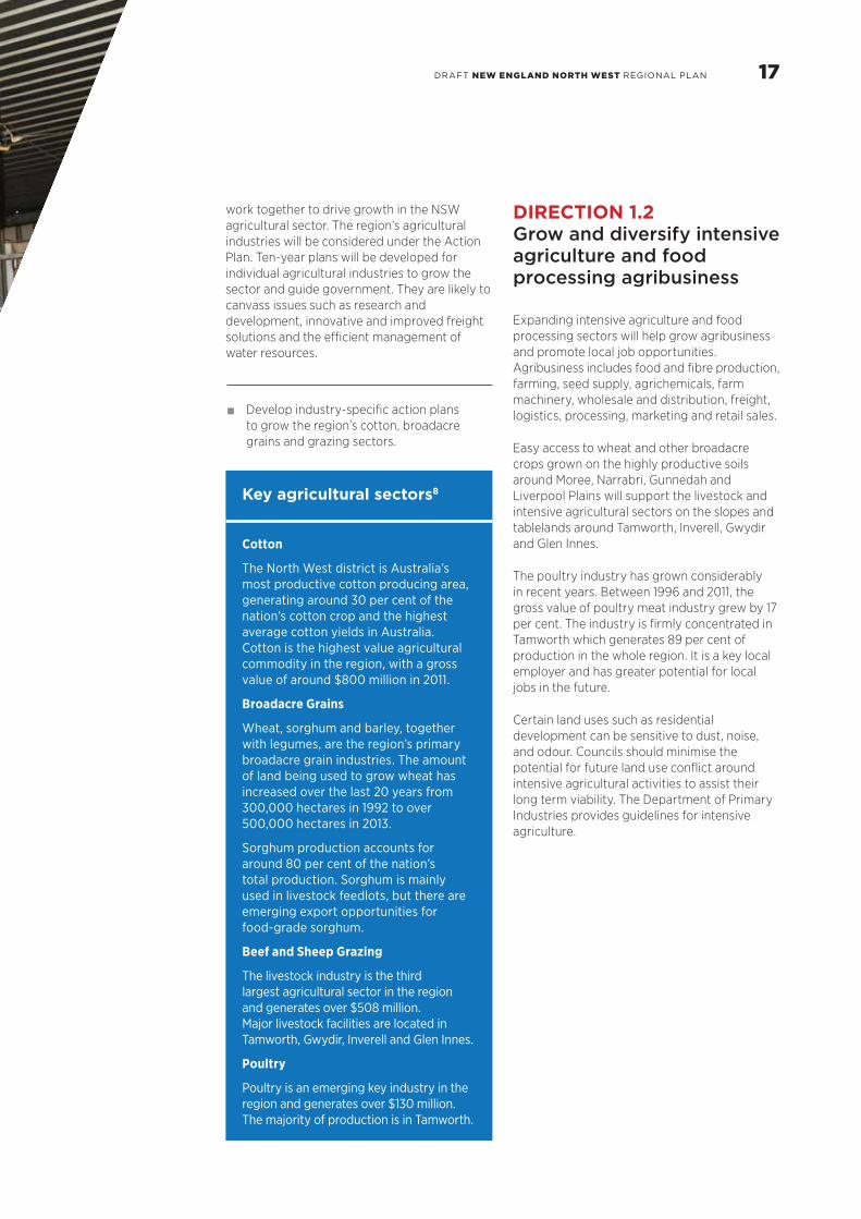
17 DIRECTION 1.2 Grow and diversify intensive agriculture and food processing agribusiness
19 DIRECTION 1.3 Protect agricultural land from urban encroachment and fragmentation
27 DIRECTION 1.4 Increase opportunities to move agricultural produce to market
33 GOAL 2 – A diversified economy through the management of mineral and energy resources including renewable energy generation
35 DIRECTION 2.1 Deliver economic diversity through sustainable use of, and access to mineral and energy resources
36 DIRECTION 2.2 Manage competing and conflicting interests in rural and resource areas to provide greater certainty for investment
39 DIRECTION 2.3 Increase opportunities for renewable energy generation
43 GOAL 3 – Communities resilient to change, with housing choice and services that meet shifting needs and lifestyles
45 DIRECTION 3.1 Strengthen community resilience
47 DIRECTION 3.2 Plan for housing to meet the needs of a growing and changing population
49 DIRECTION 3.3 Deliver housing choice to suit changing needs
49 DIRECTION 3.4 Promote sustainable settlement growth with great places to live
52 DIRECTION 3.5 Increase access to health and education services
54 DIRECTION 3.6 Coordinate infrastructure delivery
57 GOAL 4 – Prosperous urban centres with job opportunities
57 DIRECTION 4.1 Grow the regional cities of Tamworth and Armidale
59 DIRECTION 4.2 Enhance access to jobs, goods and services by improving connections between centres
63 DIRECTION 4.3 Provide well-located and serviced supplies of industrial and employment lands
65 DIRECTION 4.4 Enhance the viability and vitality of commercial centres
67 DIRECTION 4.5 Grow tourism to support employment opportunities and urban centres
69 GOAL 5 – Protected water, environment and heritage
69 DIRECTION 5.1 Manage water resources for a growing economy and environmental sustainability
72 DIRECTION 5.2 Protect areas of high environmental value
76 DIRECTION 5.3 Protect Aboriginal and historic heritage
77 DIRECTION 5.4 Adapt to natural hazards and climate change
80 Endnotes
Top: Lambert Park, Armidale
Bottom: Family fossickingnear Inverell


The Draft New England North West Regional Plan applies to 12 local government areas – Tenterfield, Glen Innes Severn, Inverell, Armidale Regional, Uralla, Walcha, Gwydir, Tamworth Regional, Liverpool Plains, Gunnedah, Narrabri and Moree Plains.
The region encompasses the traditional lands of the Anaiwan, Banbai, Bundjalung, Githabul, Gumbaynggirr, Kamilaroi, Kwaimbul, Ngoorabal and Dunghutti peoples.
This is a region of diverse landscapes, including rainforest-covered volcanic plateaus and escarpments, alpine communities on the Great Dividing Range, remnant inland forests, wetlands of national and international significance, diverse grasslands and productive wide open slopes and plains. These landscapes underpin a quarter of the State’s agricultural output, represent the State’s third largest coal reserves and include significant biodiversity.
The New England North West has a strong and growing economy that is valued at almost $8.9 billion and supports almost 67,000 jobs. The economy grew by 5.1 per cent between 2006 and 2013, which is higher than the 4.8 per cent growth rate for regional NSW over the same period.1
The agricultural and natural resource sectors are at the centre of this region’s economic future. Total agricultural activities contribute around $2.5 billion to the NSW and national economy,2 making the region one of the State’s most significant agricultural producers. Mineral and energy resources contribute in the order of $1.7 billion to the region. The development of these resources, in appropriate locations, will provide more local job opportunities and expand mining-related services. As a prime location for wind and solar power, the region has the potential to be a leader in renewable energy generation.
Over the next 20 years to 2036, the population is expected to grow by 13,800 to over 202,000. The two regional cities, Tamworth and Armidale, will support over half the region’s population by 2036 and their development will help to drive growth for the region. A further 28 per cent of the population will reside in the four strategic centres of Inverell, Narrabri, Gunnedah and Moree.3
The service sectors located in urban centres are important to the economic prosperity of the region, representing almost two-thirds of employment and almost half of the output of the region. The health and education sectors account for 24 per cent of the workforce and will continue to grow and expand.4
Located between Sydney and Brisbane, with good transport connections to Newcastle and South East Queensland, the region is well located to access both domestic and international markets. Producers can choose to move goods north to Brisbane, or south-east to Newcastle and Sydney. The movement of coal dominates the rail freight network. Freight movements generated by the coal industry are funding improved access along the Hunter Valley Coal Chain.
This draft Plan promotes a holistic approach to land, environmental, water and natural resource management. It aims to maintain the productive capacity of natural resources, improve the agriculture sector’s capacity to cope with changes in markets and weather patterns, and maintain and preserve areas of high environmental value, water catchments and heritage. It provides an overarching framework to guide development and investment in the New England North West to 2036.
The draft Plan consolidates strategic planning considerations for land use and infrastructure for the local government areas of the New England North West. Once the plan is finalised, it will replace the New England North West Strategic Regional Land Use Plan, released by the NSW Government in 2012. The relevant policies will continue to apply and are addressed in this draft plan.
Introduction
Top: Grain storage and freight movements in Moree
Bottom: Grey Street, Glen Innes
5DRAFT NEW ENGLAND NORTH WEST REGIONAL PLAN

Underpinning the planning framework for this draft Plan are the following key principles:
• facilitate economic growth, environmental management and social wellbeing;
• respond to the region’s landscape, environmental assets, natural and cultural resources, mineral and energy resources, (including renewable energy);
• respond to long term structural economic and demographic changes, with a focus on ageing, migration patterns and productivity;
• address the implications of climate change and build resilience to natural hazards;
• guide the locations for new housing and provide a diversity of housing choice;
• facilitate economic activities consistent with changing market demands and industry needs;
• inform infrastructure and services investment, coordinated with land use; and
• integrate cross-border drivers of change and coordinate responses Statewide and nationally.
New England North West districts
The New England North West has two discrete districts that focus on specific centres and reflect shared characteristics, landforms, land use, geographical proximity, social links and existing services. These districts are:
• New England – comprising Tenterfield, Inverell, Glen Innes Severn, Armidale Regional, Walcha and Uralla Local Government Areas; and
• North West – comprising Moree Plains, Gwydir, Narrabri, Gunnedah, Liverpool Plains and Tamworth Regional Local Government Areas.
Developing the draft Plan
The draft Plan incorporates research and expert advice about future development challenges and opportunities. Engagement with councils helped to identify community and stakeholder issues.
The following evidence forms the basis of the draft Plan:
• Department of Planning and Environment (2016), NSW Population Projections 2011-36;
• SGS Economics and Planning (2016), Housing Analysis of the New England North West;
• RMCG (2015), Agricultural Expansion Analysis: New England North West;
• Department of Planning and Environment (2016), New England North West Housing and Land Monitor;
• Department of Planning and Infrastructure (2012), New England North West Strategic Regional Land Use Plan; and
• Department of Industry (Division of Resources and Energy) Geoscientific Data, including data held on the Common Ground website.
Additional evidence was also considered as follows:
• Transport for NSW (2013), New England North West Regional Transport Plan;
• Office of Environment and Heritage (2015), Potential High Environmental Value Mapping;
• Department of Industry (2015), Economic Development Strategy for Regional NSW;
• Northern Inland Regional Development Australia (2012), Northern Inland Region of NSW – Freight Study; and
• Catchment Action Plans.
6

FIGURE 1: BUILDING THE DRAFT PLAN
Use economicassets to buildprosperity and
create resilienceto environmental,
social and economicchange
Locate newgrowth to build
the environmentalperformance ofour urban areas
Apply aprecautionary
approach
Understand ourenvironmental
and socialbaseline
Community and industry engagement
• Base design on previous plans and strategies (biodiversity, conservation and regional schemes)
• Use O�ce of Environment and Heritage (OEH) environmental mapping
• Understand and respond to hazards
• Use accurate demographic and housing projections to understand growth
• Protect areas of high environmental value,and Aboriginal and historic heritage
• Build resilience in the environment and reinvest development outcomes (biodiversity certification and biobanking)
• Protect important agricultural lands
• Balance land use conflict
• Use resources responsibly so that they are available for future generations
• Invest in infrastructure that generates economic opportunities
• Support the major growth centres for housing and jobs growth
• Push for development of health, education and aviation precincts
• Cluster commercial facilities in main streets and town centres
• Develop the agribusiness sector
• Apply Settlement Planning Principles for urban and rural residential releases
• Support urban land releases with appropriate infrastructure
• Promote urbandesign that creates active and socially responsible spaces
7DRAFT NEW ENGLAND NORTH WEST REGIONAL PLAN

Achieving the vision and the goals of the final Plan will be a shared responsibility, requiring ongoing commitment from all stakeholders, including councils, agencies and the development and services sectors.
Governance
A Coordination and Monitoring Committee will be established to oversee the implementation of the final Plan. It will comprise representatives from the Department of Planning and Environment, two Local Government representatives determined by the Regional Organisations of Councils (or Joint Organisations once established), Department of Premier and Cabinet, Office of Environment and Heritage, Transport for NSW and Department of Industry (including Department of Primary Industries).
Delivering the Plan
The committee will:
• coordinate and drive delivery of actions, supported by an Implementation Plan;
• establish a framework to monitor issues such as:
population;
housing;
economy and employment; and
natural environment and resources;
• prepare an annual report detailing progress against the actions identified in the Plan; and
• review, update and revise the Plan every five years or as necessary.
FIGURE 2: COORDINATION AND MONITORING COMMITTEE
SUPPORTING GROUPS
O�ce ofEnvironmentand Heritage
Departmentof Industry
Transportfor NSW
Departmentof Premier
and Cabinet
NENW Coordinating and Monitoring Committee
Representatives(from Joint
Organisations and Regional Organisations
of Councils)
ChairNSW Department of Planning and
Environment
The committee will be supplemented by representatives from other State agencies or specific groups to manage particular issues or projects, for example, Regional
Development Australia, Regional Tourism Boards and Organisations, peak industry bodies, service providers, utility providers, technical experts or other relevant stakeholders.
8

The NSW Government will use the final Plan, along with annual monitoring of development activity to advise infrastructure agencies about the timing of new developments in order to inform infrastructure service planning, asset management and services. Opportunities for private sector delivery of infrastructure will also be explored to support growth.
The NSW Government will continue to work with State infrastructure providers to plan and deliver infrastructure that responds to place and community needs across regional NSW. This includes:
• aligning future infrastructure priorities to support planned growth and change;
• coordinating infrastructure delivery to support strategic employment and housing land; and
• exploring innovative design and delivery approaches across infrastructure sectors.
Local planning initiatives
A Ministerial Direction will require all councils to implement the objectives and actions of the final Plan, appropriate to their local area, in their council planning strategies and local environmental plans.
Reviews of and amendments to planning strategies and local environmental plans will need to be consistent with the policies and actions in the final Plan.
Once finalised, the Plan will replace the current strategic plan for the region, the New England North West Strategic Regional Land Use Plan.The relevant policies will continue to apply and are addressed in this draft plan.
The Coordination and Monitoring Committee will be chaired by the Department of Planning and Environment to oversee progress on projects and identify where policy interventions or resourcing may be required.
It will be supplemented by outcome-specific groups that bring in appropriate personnel to provide advice on particular issues or projects in the Plan.
Implementation
The actions in the final New England North West Regional Plan will be implemented through:
• local planning directions under section 117 of the Environmental Planning and Assessment Act 1979, issued by the Minister for Planning;
• whole-of-government policy alignment; and
• regional collaboration across government, business, key stakeholders and the wider community for specific projects and processes.
The NSW Government will be responsible for implementing these actions and will work with councils on relevant initiatives.
Infrastructure coordination
The draft Plan aligns regional planning for housing and economic activity to existing and planned infrastructure investments. The infrastructure context and priorities in this draft Plan are drawn from the Rebuilding NSW – State Infrastructure Strategy (2014), NSW Long Term Transport Master Plan (2012), the Economic Development Strategy for Regional NSW (2015), New England North West Regional Transport Plan (2013), NSW Freight and Ports Strategy (2013), Local Water Utilities’ strategic business plans and the operational plans of electricity providers.
ANZAC Park playground, Glen Innes

10
The region has maximised its expanding cotton, cereals, coal and solar energy potential in the west, and beef, fine wool and wind energy potential in the east, to create resilient and prosperous communities.
The New England North West is a strong, diverse and sustainable regional economy that has responded to changing agricultural practices and the expansion of mineral and energy resource sectors. Economic growth is supported by expanding service jobs and industries.
New opportunities to grow the agriculture sector continue to be promoted. Sheep and cattle grazing, broadacre cereal crops, irrigated cotton, intensive livestock and plant agriculture and poultry production thrives and diversifies through innovation and efficiency improvements.
Important agricultural land is protected as a fundamental component of the region’s rural identity and economic prosperity. The region’s agricultural producers are leaders in sustainable, water-efficient food and fibre production.
Development opportunities around intensive agriculture and food processing industries have created new local job opportunities.
Investment in natural resources has enabled the delivery of new industries, more local jobs and has leveraged the region’s skilled and innovative workforce.
The potential to generate wind power on the tablelands and solar power in the west has been harnessed and this power added to the electricity grid to contribute to targets for renewable energy generation.
The region’s diverse settlements have distinctive characteristics. Communities have great places to live, work, visit and invest. The regional cities of Tamworth and Armidale thrive as centres of activity, providing more jobs, greater housing choice and high levels of services, including education, health and recreation.
Water demands have been managed to support industry, jobs and communities. This region has adapted to the water access reforms under the Murray-Darling Basin Plan and urban settlements have access to safe and reliable water supplies.
Natural and cultural heritage assets have been conserved and celebrated, including the World Heritage listed Washpool, Gibraltar Range, Oxley Wild Rivers and Werrikimbe National Parks, the largest semi-arid woodland in NSW at Pilliga, and the nationally recognised Myall Creek Massacre and Memorial site.
VisionA sustainable future that maximises the advantages of the region’s diverse climates, landscapes and resources.

11DRAFT NEW ENGLAND NORTH WEST REGIONAL PLAN
To achieve this vision, the NSW Government has set the following regionally focused goals:
• A growing and diversified agricultural sector;
• A diversified economy through the management of mineral and energy resources, including renewable energy generation;
• Communities resilient to change, with housing choice and services that meet shifting needs and lifestyles;
• Prosperous urban centres with job opportunities; and
• Protected water, environment and heritage.

Regional City
Strategic Centre
Centre
Local Government Area
District Boundary
Highway
Main Road
Railway
Airport
Hospital
Health Services Precinct
Education Precinct
World Heritage Area
National Park and Reserve
State Forest
Waterway
FIGURE 3: REGIONAL PLAN STRATEGY

13

14

15DRAFT NEW ENGLAND NORTH WEST REGIONAL PLAN
Top: Cattle grazing, Armidale
Centre: Cotton farm, Moree
Bottom: Farm irrigation, Gunnedah
GOAL 1 – A growing and diversified agricultural sector
The New England North West is one of the strongest economies in regional NSW. It boasts highly productive agricultural industries due to superior soils, high land capability, good rainfall and a temperate climate. Productive agricultural land covers around 67 per cent of the region, making it one of the top agricultural producing regions in NSW, generating around $2.5 billion in 2011.5
The growth of the broadacre agriculture and grazing sectors, and the expansion of intensive agriculture and food processing will continue to drive economic prosperity and jobs growth.
Agricultural industries have seized opportunities to increase productivity and production levels through research and development and by diversifying production. Broadacre agriculture and grazing are well established industries and leaders in agricultural production. Future priorities for these industries include research and development and improvements in freight networks.
The intensive agriculture and food processing sectors are rapidly expanding.6 The poultry industry in particular has significantly grown around Tamworth. These sectors provide opportunities to diversify the agricultural economy and promote value-adding opportunities. They can capitalise on the region’s grain and feed production, freight networks and proximity and access to significant national and international markets.
Competition between land uses in rural areas can affect the continued productivity of agricultural land. The draft Plan protects existing agricultural land from uses that compromise long term agricultural productivity and maximises opportunities for co-existence with non-agricultural uses.
The NSW Government has developed the Right to Farm Policy, which presents a comprehensive approach to dealing with the right of farmers to undertake lawful agricultural practices without conflict or interference arising from complaints from neighbours and other land uses.
Agricultural industries rely on efficient freight networks and benefit from access to domestic and international markets due to the proximity of the ports of Newcastle, Brisbane and Sydney and the three international airports. The Newell and New England Highways and the rail line to Newcastle and Sydney provide bulk shipping and high capacity freight networks that are capable of maintaining high levels of productivity and the competitiveness of the region’s agricultural industries. Potential new opportunities exist with the introduction of overseas freight capacity at Toowoomba, Queensland.
The draft Plan:
• promotes the growth of broadacre agriculture and grazing by improving the efficiency of freight networks and applying appropriate controls to support these industries;
• promotes opportunities to expand intensive agriculture and food processing by identifying emerging development opportunities and streamlining approval processes;
• protects agricultural land by limiting land fragmentation and development on important agricultural land; and
• protects the future development of freight and logistics precincts and identifies opportunities to provide greater access for high productivity vehicles.

research and development aimed at innovation in farming practices and the adoption of new technologies that help to sustain production and productivity, open new market opportunities and maintain a competitive edge in the face of economic and climatic challenges.
The application of research findings can contribute to the region’s current production levels, despite the risks posed by reductions in water availability and increasing soil and plant evaporation.
Councils will need to consider the encroachment of potential urban and rural residential uses onto regionally important agricultural land. They will also need to provide an adequate supply of land and flexible planning controls to enable a range of development opportunities for broadacre agriculture and livestock industries, including research institutions and applied research and development jobs.
ACTION 1.1.1 Implement the Government’s Agriculture Industry Action Plan
The Department of Primary Industries Agriculture Industry Action Plan-Primed for growth: Investing locally and connecting globally (2014) provides a roadmap of actions and strategies for industry and government to
DIRECTION 1.1 Grow broadacre agriculture and livestock grazing sectors
The New England North West’s three largest agribusiness sectors are cotton, broadacre grains and livestock grazing. Together, they represent around three-quarters of the region’s total agricultural production. These sectors benefit from the strong local presence of supporting agribusinesses covering bulk handling, marketing, export and processing.
International trade agreements will provide enormous potential for growth; however, farming communities may also face significant challenges. With farm consolidation and capital investment in labour-saving technologies there has been a shift in the type of jobs available. There are now fewer jobs for lower skilled farm labourers. This is reflected in a decline in the number of people employed in agriculture since 1996.7 These trends are likely to continue and ongoing innovation in agricultural practices, as well as the creation of new markets to Asia, will be necessary to meet the challenges of climate change, water availability, variable soil conditions and agronomic factors.
The region has some of the largest agricultural research and development institutions in NSW, with major facilities at Tamworth, Armidale, Narrabri and Glen Innes. These facilities provide
Wool classing near Armidale, Courtesy of TAFE New England
Key agricultural sectors8
Cotton
The North West district is Australia’s most productive cotton producing area, generating around 30 per cent of the nation’s cotton crop and the highest average cotton yields in Australia. Cotton is the highest value agricultural commodity in the region, with a gross value of around $800 million in 2011.
Broadacre Grains
Wheat, sorghum and barley, together with legumes, are the region’s primary broadacre grain industries. The amount of land being used to grow wheat has increased over the last 20 years from 300,000 hectares in 1992 to over 500,000 hectares in 2013.
Sorghum production accounts for around 80 per cent of the nation’s total production. Sorghum is mainly used in livestock feedlots, but there are emerging export opportunities for food-grade sorghum.
Beef and Sheep Grazing
The livestock industry is the third largest agricultural sector in the region and generates over $508 million. Major livestock facilities are located in Tamworth, Gwydir, Inverell and Glen Innes.
Poultry
Poultry is an emerging key industry in the region and generates over $130 million. The majority of production is in Tamworth.
work together to drive growth in the NSW agricultural sector. The region’s agricultural industries will be considered under the Action Plan. Ten-year plans will be developed for individual agricultural industries to grow the sector and guide government. They are likely to canvass issues such as research and development, innovative and improved freight solutions and the efficient management of water resources.
• Develop industry-specific action plans to grow the region’s cotton, broadacre grains and grazing sectors.
DIRECTION 1.2 Grow and diversify intensive agriculture and food processing agribusiness
Expanding intensive agriculture and food processing sectors will help grow agribusiness and promote local job opportunities. Agribusiness includes food and fibre production, farming, seed supply, agrichemicals, farm machinery, wholesale and distribution, freight, logistics, processing, marketing and retail sales.
Easy access to wheat and other broadacre crops grown on the highly productive soils around Moree, Narrabri, Gunnedah and Liverpool Plains will support the livestock and intensive agricultural sectors on the slopes and tablelands around Tamworth, Inverell, Gwydir and Glen Innes.
The poultry industry has grown considerably in recent years. Between 1996 and 2011, the gross value of poultry meat industry grew by 17 per cent. The industry is firmly concentrated in Tamworth which generates 89 per cent of production in the whole region. It is a key local employer and has greater potential for local jobs in the future.
Certain land uses such as residential development can be sensitive to dust, noise, and odour. Councils should minimise the potential for future land use conflict around intensive agricultural activities to assist their long term viability. The Department of Primary Industries provides guidelines for intensive agriculture.
17DRAFT NEW ENGLAND NORTH WEST REGIONAL PLAN

Intensive Agriculture in the New England North West9
Tamworth has a number of food processing facilities, including abattoirs, poultry processing plants and a large wheat mill. Narrabri has the largest oilseed crushing plant in Australia and the only cottonseed crushing plant operating in NSW. Inverell is the operating centre for a large beef processing company. There are four large cattle feedlots (20,000 plus head) operating in the Liverpool Plains, Gwydir and Glen Innes Severn Local Government Areas.
In 2011, the poultry meat industry in the region accounted for 19 per cent of the State’s gross value of poultry meat and was worth around $131 million. The poultry industry represented 5 per cent of the gross agricultural value in the region. The number of birds grown for meat has increased from around 1 million in 1996 to 5 million in 2013. In 2011, the then Guyra Shire produced 56 per cent of the gross value of the State’s tomato production.
FIGURE 4: VALUE OF INTENSIVE AGRICULTURE IN THE NEW ENGLAND NORTH WEST (1996–2011)
Source: RMCG (2015) Agricultural Expansion Analysis
0
5
10
15
20
25
30
35
1996 2001 2006 2011
0
20
40
60
80
100
120
140
160
180
Val
ue (
$m
) fo
r P
oul
try
Mea
t, P
oul
try
Eg
gs
and
Pig
s
Val
ue (
$m
) fo
r V
eget
able
s an
d F
ruit
Poultry Meat, Poultry Eggs and PigsVegetables Fruit
Duck farm, Liverpool Plains
18

ACTION 1.2.1 Prepare and implement a Regional Intensive Agribusiness Strategy to support new opportunities for intensive agricultural and food processing agribusinesses
The Regional Intensive Agribusiness Strategy will identify locations with potential for intensive agricultural development. This will leverage economies of scale and infrastructure benefits by developing clusters of complementary activities. There are opportunities to co-locate industries to use the by-products and waste materials to create new products and services. Providing a sufficient supply of land in appropriate locations will help to facilitate employment opportunities and infrastructure and services.
The strategy will also include Intensive Agricultural and Food Processing Guidelines to minimise the effects of development and assist the local government approval process. It may include the design and layout of intensive agricultural and food processing developments. Strategies to facilitate the growth of agribusiness will also support the strength of the region’s agricultural productivity and contribute to the diversification of the region’s economy.
• Work with councils to prepare a New England North West Regional Intensive Agribusiness Strategy that includes:
Intensive Agriculture and Food Processing Guidelines; and
mapping of suitable future precincts for intensive agricultural production and food processing.
DIRECTION 1.3 Protect agricultural land from urban encroachment and fragmentation
The New England North West has some of the State’s most fertile and productive agricultural areas, with very high class soil and land capability (see Figure 5). Limiting the subdivision of agricultural land will maintain viable and productive farming activity.
Figure 6 shows rural landholding sizes for the region in 2015. Monitoring landholding size changes over time will identify emerging trends in agriculture, the pattern of rural subdivision and the degree of fragmentation or consolidation of rural lands. This will help councils to review and update minimum lot sizes in their local environment plans.
Protecting rural uses from encroachment by sensitive land uses can often be avoided by applying buffers using distance, vegetation or topography.
Fruit and vegetable crops are common on smaller holdings throughout the region. Identifying suitable areas for smaller agricultural holdings will help to minimise the occurrence of incompatible land uses and prevent fragmentation of land. Councils should investigate ways to provide development opportunities for this type of agriculture.
The encroachment of urban uses into agricultural areas can increase biosecurity risks from pests, diseases and invasive species. Risks are increasing due to the globalisation of trade, population growth, climate variability and competing priorities for land and resources, including land use conflicts.10
19DRAFT NEW ENGLAND NORTH WEST REGIONAL PLAN

LAND CAPABILITY CLASS RATINGS
Very High
High
Moderate
Moderate to Low
Low
Very Low
Extremely Low
Waterway
Local Government Area
FIGURE 5: LAND AND SOIL CAPABILITY IN THE NEW ENGLAND NORTH WEST


LANDHOLDINGS SIZE (HA)
0–1
1–50
51–100
101–200
201–400
401–600
601+
Crown Land
National Park
State Forest
Local Government Area
Highway
Main Road
FIGURE 6: LANDHOLDING SIZE ANALYSIS (2015)


Land use planning can support the effective management of biosecurity risks, particularly where the expansion of residential development into rural areas or the expansion of rural or resource industries increases risk. New industries should be located where the potential for conflict with agriculture can be minimised.
Travelling Stock Reserves are parcels of Crown Land reserved under legislation to provide pasture for travelling or grazing stock. These reserves can be beneficial in times of drought, bushfire or flood. They are also used for public recreation, beekeeping sites and conservation. Local Land Services manage the land to strike a balance between the needs of travelling stock and the conservation of native species. Many travelling stock routes have high biodiversity and Aboriginal cultural heritage values.
ACTION 1.3.1 Identify and protect important agricultural lands
Biophysical Strategic Agricultural Land is high quality agricultural land based on characteristics such as soil fertility, access to water and land capability. It is naturally capable of sustaining high levels of productivity and requires minimal management to maintain its quality.
Biophysical Strategic Agricultural Land was mapped in the region in 2012 (see Figure 7). It covers over 1.5 million hectares or around 15 per cent of the New England North West.
Agriculture, Narrabri
There is an opportunity to complement the existing Biophysical Strategic Agricultural Land mapping with additional regional-scale mapping that reflects regional climatic and geographic conditions, as well as regional industry needs.
Important agricultural land will be mapped to guide government when making planning decisions, preparing local plans and investing in infrastructure. The maps can be used to identify areas with potential for land use conflicts, such as the expansion of rural residential uses. The mapping will provide industry with information on the existing agricultural production in the region. It will also identify land that is suitable for future investment for agricultural production and associated activities, such as value-adding/processing, and farm stay accommodation.
The NSW Government will develop guidelines for councils about planning for urban or rural residential development on important agricultural land, including mapped Biophysical Strategic Agricultural Land. These guidelines will also assist councils to identify issues they need to consider when preparing local strategies or planning controls.
• Develop maps that identify important agricultural land.
• Limit urban and rural residential development on important agricultural land, including mapped Biophysical Strategic Agricultural Land unless it is in a strategy that is:
agreed between council and the Department of Planning and Environment; and
consistent with the guidelines for councils on regionally important agricultural land.
24

FIGURE 7: BIOPHYSICAL STRATEGIC AGRICULTURAL LAND
Regional City
Strategic Centre
Centre
Local Government Area
Highway
Main Road
Railway
Biophysical Strategic Agricultural Land
National Park and Reserves
State Forest
Waterway

Packaging flour for wholesale distribution at Wholegrain Milling, Gunnedah
ACTION 1.3.3 Increase the region’s biosecurity through the use of buffers and land use conflict risk assessment
Biosecurity issues can occur at the interface between urban and rural areas, which increases the risk of animal and plant pests and diseases affecting food production, the environment (particularly wildlife) and human health. Development near freshwater catchments is also important to protect natural waterways from pest fish, such as Tilapia.
The risks to biosecurity can be minimised through the application of buffers to separate different land uses. This can be done by distance, the use of vegetation or topography.
The NSW Government’s commitment to strengthen and maintain biosecurity measures across NSW is reflected across a number of documents including the NSW Biosecurity Strategy 2013-2021, the NSW Weeds Action Program 2015-2020 and the Draft NSW Invasive Species Plan 2015- 2022. Local Land Services will continue to play a key role in this issue, in collaboration with other organisations such as the NSW Department of Primary Industries.
• Consider opportunities to minimise biosecurity risks for current and future industries through biosecurity plans, and strategic planning (including a review of zones in local plans).
• Promote the application of buffer areas to minimise biosecurity risks when assessing the potential impacts of new development.
Biosecurity
The Department of Primary Industries has developed the Biosecurity Strategy 2013–2021 to better manage biosecurity risks. It includes the following actions:
• review existing NSW legislation, taking into consideration legislation in other jurisdictions; and
• support the development of best- practice guidelines that outline the roles and responsibilities of stakeholders in biosecurity management.
ACTION 1.3.2 Limit fragmentation of agricultural land and minimise incompatible land uses on or near agricultural land
Protecting agricultural land has historically been achieved by limiting rural land subdivision. Councils should try to retain existing large rural landholdings to maximise production efficiencies and the viability of agricultural sectors. Applying provisions that limit the development of dwellings that are not a primary residence or associated with agriculture will also avoid potential conflicts with agricultural activities. Before approving secondary dwellings or detached dual occupancies in rural areas, councils should consider the possible land use conflicts and the impacts on local agricultural activities.
Councils can identify certain agricultural areas for inclusion in the primary production small lot zone. Local environmental plans can also be used to support these industries, with provisions such as farm boundary adjustments, subdivisions to create a primary production lot without a dwelling and rural worker dwelling controls. The provisions should offer flexibility and opportunity, but prevent fragmentation.
• Monitor annual changes in landholding sizes for each local government area.
• Apply appropriate minimum subdivision standards in rural zones.
• Apply appropriate local planning provisions for rural dwellings to avoid potential conflicts with agricultural activities.
• Develop local planning provisions to avoid and manage conflicts between land uses to help councils assess applications in rural areas.
• Where necessary, conduct land use risk assessments in accordance with the Department of Primary Industries Land Use Conflict Risk Assessment Guidelines (2011).
• Consider appropriate locations and apply minimum lot sizes for areas with a capacity to support existing and emerging intensive small-lot primary production.
26

A number of freight issues affecting agricultural producers arise outside the New England North West, including access, load scheduling and capacity at port facilities. The NSW Government’s NSW Freight and Ports Strategy aims to grow port capacity to match commodity throughput demands. This will improve agricultural export opportunities from the region.
The NSW Government continues to invest in rail capacity through the Fixing Country Rail program. The Australian Government is considering a proposed new inland rail corridor providing direct links from the region into Queensland (potentially to the Port of Brisbane). This would reduce the road freight demands on the Newell Highway. The NSW Government will continue to work with the Australian Government on an agreement for the rail corridor.
ACTION 1.4.1 Investigate opportunities to improve local road connections
All levels of government and stakeholders need to work together to improve freight networks. Local pinch points limit connections with the State and national road network and reduce productivity. The NSW Government will help councils to develop a prioritised rolling program of works to upgrade and improve local roads.
Through the NSW Government’s $550 million Fixing Country Roads and $345 million Bridges for the Bush programs, targeted funding is available to resolve constraints on local road networks and reduce the cost for businesses of transporting goods to market. The programs are funding vital road and bridge upgrades to better connect local and regional roads to highways and freight hubs such as silos, saleyards, rail heads, supermarket distribution centres, industrial parks and depots.
• Work with councils to identify, coordinate and prioritise local road projects that help support the regional freight network.
ACTION 1.3.4 Manage and protect travelling stock reserves for their economic, environmental and social values
Local Land Services are developing a NSW travelling stock reserve state planning framework that will guide how they manage travelling stock reserves with multiple values. Councils will consider incorporating the management arrangements for these reserves in planning strategies and local environmental plans.
• Complete a NSW travelling stock reserve state planning framework to guide the management of travelling stock reserves under the care of Local Land Services.
• Work with councils to identify reserves in planning strategies and local environmental plans.
DIRECTION 1.4 Increase opportunities to move agricultural produce to market
Agricultural producers can transport agri-cultural produce for export north to the Port of Brisbane or Brisbane West Wellcamp Airport (Toowoomba) or south to the Ports of Newcastle and Botany.
The NSW Government is continuing to define and strengthen the freight network across the region. Bridge upgrades along the Kamilaroi and Oxley Highways at Wee Waa and Tamworth will increase the efficiency and safety of freight movements across the region. The NSW Government will continue to explore options and opportunities for a suitable second freight route across the rail line at Gunnedah.
The region currently has intermodal facilities at Narrabri, Moree and Wee Waa. There are opportunities to expand these facilities to shift agricultural freight from bulk to smaller volumes by packaging in containers for export.
27DRAFT NEW ENGLAND NORTH WEST REGIONAL PLAN

ACTION 1.4.2 Investigate opportunities for increased rail freight
The region’s outbound containerised agricultural freight is forecast to grow by nearly 10,000 TEUs (Twenty-foot Equivalent Units) by 2031, with meat and grains experiencing the highest growth.11 There are opportunities to cluster complementary activities to create freight and logistics precincts, based around freight intermodal terminals.
The NSW Government supports regional intermodal terminals and their ongoing role in the freight system. Transport for NSW is committed to engaging with councils to explore planning issues associated with the development of intermodal terminals within industrial precincts, including adjoining land use, and road and rail access to proposed sites.
The Rebuilding NSW – State Infrastructure Strategy (2014) reserved $400 million for the Fixing Country Rail program to meet the forecast growth in rail freight demand and support primary producers.
• Implement local planning controls to protect freight and logistics facilities from encroachment of sensitive land uses.
• Protect freight and transport corridors, and strategically locate freight intermodal terminals to support further industry development.
ACTION 1.4.3 Work with the Australian Government on the proposed Melbourne-Brisbane Inland Rail Corridor
The Melbourne-Brisbane Inland Rail Alignment Study (2010), prepared by the Australian Rail Track Corporation (ARTC), identified the preferred corridor for inland rail, passing through the region in Narrabri, Moree Plains and Gwydir. The fine-scale alignment of the corridor is yet to be settled. The Australian Government and ARTC are working to finalise planning, engineering design and assessment for the corridor.
• Work with the Australian Government to develop an agreement to finalise planning, engineering design and assessment of the Melbourne-Brisbane Inland Rail corridor.
ACTION 1.4.4 Investigate opportunities to provide greater access for high productivity vehicles
High productivity vehicles improve the efficient movement of freight for transport operators, producers and consumers. Infrastructure constraints, however, may make it unsafe for these vehicles to traverse some bridges and roads.
The pilot Namoi Joint Organisation of Councils is undertaking a heavy vehicle route analysis to identify infrastructure constraints and impediments to current and future heavy vehicle access. One of the objectives of this work is to identify an approved regional road train network.
The Rebuilding NSW – State Infrastructure Strategy (2014) reserved $2 billion for the regional road freight corridor and $443 million for the Fixing Country Roads program,12 which will target regional road freight improvements.
• Support the work of councils to investigate funding opportunities to provide greater access for high productivity vehicles across the region to support freight productivity.
28

Case Study: Connections with Queensland
The Newell and New England Highways and Mount Lindesay Road provide road connections to Queensland. Cross-border connectivity between NSW and Queensland will help accommodate the forecast growth of freight movements on the border.
The Newell Highway facilitates the movement of produce and services to regional primary industries and export markets. High value agricultural produce, such as grain, is transported from the North West to Brisbane West Wellcamp Airport (Toowoomba), the Port of Brisbane and Brisbane Airport for export. Livestock from the Moree Plains is typically moved to the Darling Downs for finishing at large South East Queensland feedlots.
The Bruxner Highway provides an important link to southern Queensland for the movement of commodities to the Port of Brisbane via Texas. The New England Highway and Mount Lindesay Road also connect the region with Queensland via Tenterfield to Brisbane West Wellcamp Airport (Toowoomba). They are important links for the meat processing industry, with produce sourced from Queensland and within the region. Around 180,000 head of box beef are distributed per year from Bindaree Beef at Inverell to international markets through the Port of Brisbane.15 Freight volumes along the New England Highway are forecast to increase by around 60 per cent to 2031.
Agricultural Frieght
There are an estimated 2.9 million tonnes of freight generated annually on broadacre grain farms in the region.13 This averages to around 640 heavy vehicle movements per day, although this fluctuates due to the harvesting of crops and seasonal demand.
Access to high productivity vehicle routes is important for transporting agricultural produce between the North West district and Queensland. The most easterly access for these vehicles is along the Newell Highway, with primary grain receival sites located at Bellata, Narrabri and Moree.
The Newell Highway is heavily used by agricultural industries, with significant tonnages of cotton, grains and stock feeds trucked north to Queensland and through to the Port of Brisbane for export. Freight volumes along the Newell Highway from Narrabri to the Queensland border are forecast to increase by around 80 per cent to 4.9 million tonnes to 2031.14 The forecast growth in freight on the Newell Highway does not take into account the proposed Melbourne – Brisbane Inland Rail Corridor.
Adding overtaking lanes on the Newell Highway between Narrabri and Boggabilla will decrease travel times and improve safety. The Moree bypass will also reduce travel times and improve the efficiency of freight movements through this area and connections to Queensland.
The NSW Grain Harvest Management Scheme was developed in response to the grain industry’s need for improved productivity and efficiency of grain transport. It is designed to decrease harvest risk, protect roads and increase productivity and efficiency by facilitating the grain industry to move the average vehicle load towards 100 per cent of the allowable mass. The scheme allows for eligible heavy vehicles to exceed regulated total mass limits by up to 5 per cent when delivering cereals, oil seeds and pulses to participating grain receivers, in participating council areas.
The New England and Bruxner Highways facilitate the transport of livestock from farms to saleyards or feedlots; and from the saleyard to feedlots or abattoirs. It is estimated there are around 150 heavy vehicle movements each day when livestock feedlots are operating at full capacity.
The NSW Government’s Livestock Loading Scheme aims to improve freight productivity for the livestock sector by reducing the number of smaller truck movements. It allows for slightly increased weight limits for livestock trucks, contingent on the adoption of additional vehicle standards, safety measures and driver training.
29DRAFT NEW ENGLAND NORTH WEST REGIONAL PLAN

Regional City
Strategic Centre
Centre
Local Government Area
Highway
Main Road
Freight Rail Network
Primary Freight Route
Secondary Freight Route
Intermodal Terminal
Non-operational Intermodal Terminal
Grain Freight
Livestock Freight
Cotton Freight
Poultry Freight
National Park and Reserves
State Forest
Waterway
FIGURE 8: AGRICULTURAL FREIGHT NETWORK
30


GOAL 2 – A diversified economy through the management of mineral and energy resources, including renewable energy generation
Strategic Release Framework for Coal and Petroleum
The region has a rich and diverse geology creating future potential for mineral and energy resource exploration and production.
It is recognised that there are competing uses for land in this region and that there is a need to balance these interests in order to deliver the vision for this region. That is, to deliver a region with a sustainable future that maximises the advantages of its diverse climates, landscapes and resources.
As part of the process to achieve balanced outcomes, the NSW Government has introduced a Strategic Release Framework for Coal and Petroleum (including coal seam gas). This is a mechanism to review and define which lands may constitute new exploration release areas. New exploration licences will only be issued in areas released by the Minister for Resources and Energy after an assessment of resource potential and economic, environmental, social factors and community issues.
Community engagement and an upfront assessment of social, environmental and economic issues will occur through a preliminary regional issues assessment.
Overall, the new Framework resets the NSW Government’s approach to issuing coal and petroleum exploration titles to ensure that it is transparent, informed and consistent with the NSW Government’s broader land use resource strategies.Moree Solar Farm
The New England North West has great potential for mineral, petroleum and renewable energy generation.
The Gunnedah coal basin contains the State’s third largest coal reserves (12 per cent of NSW’s resources) and has significant potential for coal seam gas, with deposits covering over 3.4 million hectares.16 Not all the coal and coal seam gas reserves are at depths that make it feasible to consider extraction under current market and technology conditions.
The value of the region’s mining production grew by 24 per cent each year between 2006 and 2014, contributing approximately $1 billion in gross domestic product in 2014-15.17 The region will continue to benefit from the economic diversity and employment flow-on effects of the mining industry.
The largest mineral resource development is in the North West. This area contains the region’s coal and coal seam gas reserves, with existing open cut and underground mining concentrated either side of the Kamilaroi Highway between Narrabri and Werris Creek. The New England contains important deposits of other minerals, including gemstones, industrial minerals and extractive materials, with many small-scale mines in operation.
The current planning framework around mining and petroleum (including coal seam gas) proposals will continue. This will allow balance between the mining and agricultural industries, providing a range of economic opportunities for the region.
33DRAFT NEW ENGLAND NORTH WEST REGIONAL PLAN

resources throughout the region through various strategic tools to effectively manage the industry, including the Aquifer Interference Policy.
The Hunter Valley rail network is a key rail infrastructure asset as it enables the mining sector to transport coal from the Gunnedah Basin and produce from agricultural industries in the North West to the export Port of Newcastle. The movement of coal dominates the rail freight network and the coal industry is funding improved track and network capacity.
The region has potential to be a leader in the development of renewable energy generation by harnessing solar in the North West and wind energy in the New England. The region receives 19 to 20 megajoules daily of solar exposure, making it the second highest solar penetration region in NSW. Wind speeds can also reach up to 10 metres per second in some parts of the New England North West. There are proposals for large wind and solar farms that will generate job opportunities and investment in the economy from construction, operations and connection to the State’s electricity grid. These proposals have potential to provide electricity to around 285,000 homes each year, nearly
Parts of the North West’s most productive agricultural land are located in areas with economically viable mineral and energy resources.
In August 2016, the Government secured the cancellation of the Caroona mineral exploration licence, covering approximately 344 square kilometres of the Liverpool Plains. The Liverpool Plains provide some of the most productive and valuable farming land in Australia.
The NSW Government has committed to increasing its efforts to reduce the area of encroachment of coal exploration licences into the strategic agricultural land of the Liverpool Plains. Negotiations have commenced with Shenhua to relinquish parts of its mining title that encroach onto such land. The Government’s recently developed Strategic Release Framework for Coal and Petroleum includes a preliminary regional issues assessment process and community engagement to ensure that, in future, the potential impacts on a region are considered in advance of the release of exploration licences.
The NSW Government has controls in place to prevent impacts on agriculture and water
Construction of Moree Solar Farm
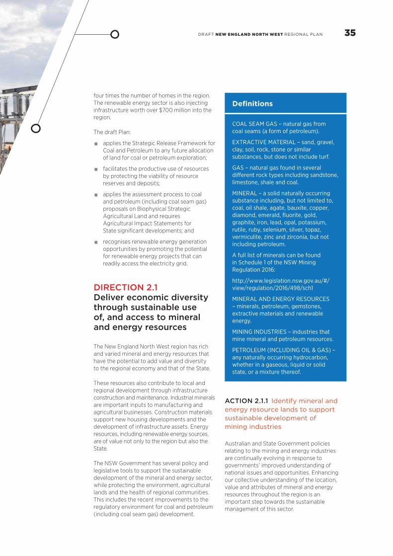
Definitions
COAL SEAM GAS – natural gas from coal seams (a form of petroleum).
EXTRACTIVE MATERIAL – sand, gravel, clay, soil, rock, stone or similar substances, but does not include turf.
GAS – natural gas found in several different rock types including sandstone, limestone, shale and coal.
MINERAL – a solid naturally occurring substance including, but not limited to, coal, oil shale, agate, bauxite, copper, diamond, emerald, fluorite, gold, graphite, iron, lead, opal, potassium, rutile, ruby, selenium, silver, topaz, vermiculite, zinc and zirconia, but not including petroleum.
A full list of minerals can be found in Schedule 1 of the NSW Mining Regulation 2016:
http://www.legislation.nsw.gov.au/#/view/regulation/2016/498/sch1
MINERAL AND ENERGY RESOURCES – minerals, petroleum, gemstones, extractive materials and renewable energy.
MINING INDUSTRIES – industries that mine mineral and petroleum resources.
PETROLEUM (INCLUDING OIL & GAS) – any naturally occurring hydrocarbon, whether in a gaseous, liquid or solid state, or a mixture thereof.
ACTION 2.1.1 Identify mineral and energy resource lands to support sustainable development of mining industries
Australian and State Government policies relating to the mining and energy industries are continually evolving in response to governments’ improved understanding of national issues and opportunities. Enhancing our collective understanding of the location, value and attributes of mineral and energy resources throughout the region is an important step towards the sustainable management of this sector.
four times the number of homes in the region. The renewable energy sector is also injecting infrastructure worth over $700 million into the region.
The draft Plan:
• applies the Strategic Release Framework for Coal and Petroleum to any future allocation of land for coal or petroleum exploration;
• facilitates the productive use of resources by protecting the viability of resource reserves and deposits;
• applies the assessment process to coal and petroleum (including coal seam gas)proposals on Biophysical Strategic Agricultural Land and requires Agricultural Impact Statements for State significant developments; and
• recognises renewable energy generation opportunities by promoting the potential for renewable energy projects that can readily access the electricity grid.
DIRECTION 2.1 Deliver economic diversity through sustainable use of, and access to mineral and energy resources
The New England North West region has rich and varied mineral and energy resources that have the potential to add value and diversity to the regional economy and that of the State.
These resources also contribute to local and regional development through infrastructure construction and maintenance. Industrial minerals are important inputs to manufacturing and agricultural businesses. Construction materials support new housing developments and the development of infrastructure assets. Energy resources, including renewable energy sources, are of value not only to the region but also the State.
The NSW Government has several policy and legislative tools to support the sustainable development of the mineral and energy sector, while protecting the environment, agricultural lands and the health of regional communities. This includes the recent improvements to the regulatory environment for coal and petroleum (including coal seam gas) development.
35DRAFT NEW ENGLAND NORTH WEST REGIONAL PLAN

Over the coming decades, the region will continue benefiting from the economic and employment flow-on effects of the development of the mineral and energy industries. The NSW Government will continue to work with the Australian Government to identify lands capable of accommodating large-scale renewable energy projects to support the development of these industries.
In addition to energy resource lands, the NSW Government has also identified mineral resource lands, which contain an array of other mineral resources that have extractive value. Many of these also provide affordable supply sources for other industries operating in the region, including for example:
• agricultural industries, which use limestone as fertiliser and clay to pelletise stockfeed;
• manufacturing industries that process clays into ceramics and bricks, limestone into cement and sands into pigments and glass; and
• construction industries, which use fine aggregates to make concrete and asphalt and coarse aggregates as road and rail ballast.
Information regarding potential and/or identified mineral and energy resources is available from the Division of Resources and Energy. The data will be updated as geological knowledge is acquired. Current resource titles and title applications are available on the Common Ground Website and geoscientific data is housed in the Department of Industry’s Geoscientific Data Warehouse.
The NSW Government has several policy and legislative tools to support the sustainable development of the mining industry, while protecting the environment, agricultural lands and the health of regional communities, as follows:
• Environmental Planning and Assessment Act 1979;
• Protection of the Environment Operations Act 1997;
• Mining 1992 and Petroleum (Onshore) Act 1991;
• Strategic Release Framework for Coal and Petroleum – a mechanism to review and define which lands may constitute new exploration lease areas for coal and petroleum (see over page);
• NSW Gas Plan (2014), which provides a more strategic and transparent approach for gas exploration through the Strategic Release Framework for Coal and Petroleum to release new areas for oil and gas exploration;
• State Environment Planning Policy (Mining, Petroleum Production and Extractive Industries) 2007, which sets out where mining, petroleum production and extractive industry activities may occur and provides decision-makers with a list of matters that must be considered in assessing a development application;
• Land Use Conflict Risk Assessment Guide; and
• the Preliminary Regional Issues Assessment for Potential Coal and Petroleum Exploration Release Areas Guidelines.
The following will support the sustainable development of the mining industry within the New England North West.
• Provide geoscience information related to the mineral and energy resources of NSW, and transparently monitor development activity. Current resource titles and title applications are available on the Common Ground website and geoscientific data is housed in the Department of Industry’s Geoscientific Data Warehouse.
• Use this information to work with councils, industries and other stakeholders to plan for the future of mining industries and identify the short, medium and long term development priorities to guide investment decisions for these industries.
DIRECTION 2.2 Manage competing and conflicting interests in rural and resource areas to provide greater certainty for investment
Ongoing investment to develop mineral and resource industries will help underpin the economic prosperity and ongoing productivity of the New England North West. This draft Plan identifies priorities for managing mineral and energy resources, Biophysical Strategic Agricultural Land (Figure 7), and the anticipated regional growth demands driving urban expansion within the regional cities and strategic centres around the New England North West.
Railway crossing, Quirindi
36

As the New England North West continues to grow, and new economic development opportunities emerge for mineral and energy resources industries, there is potential for conflict to continue, and for competition over water resources and the infrastructure necessary to support other uses.
Land use conflicts require a whole-of- government response. The NSW Government is already responding to community concerns about the long term future of coal and petroleum (including coal seam gas) mining around the State by developing a policy framework for the strategic release of areas for coal and petroleum exploration licences and assessment leases.
Most urban areas are not close to current production activities; however, land use conflicts can arise if urban uses are expanded close to mining activities or infrastructure (such as rail corridors and electricity easements). It is important that the potential impacts of mining proposals, for example, noise, vibration, dust and traffic, are rigorously assessed and mitigated. Land use planning can also assist by maintaining the availability and quality of terrestrial and aquatic resources that have the potential to sustain industries within the region.
ACTION 2.2.1 Plan for the ongoing productive use of extractive resource lands
Mining activities have specific operational needs that can compete with other sensitive uses; however, they are also temporary, dependent on the productive life of the facility or resource. As mineral and energy resources have been identified (see Action 2.1.1), there may be opportunities to identify interim activities that can occur on the land, without sterilising its future resource potential. However, any land use changes contemplated in advance of the extraction of resources must be carefully considered.
The Council of Australian Governments Standing Council on Energy and Resources prepared a Multiple Land Use Framework to assist in planning and managing multiple land uses.18 The framework includes a series of principles that can assist in planning around mineral and energy resources, where other high value land uses also exist.
Developing land use plans that respond to the lifecycle of mineral and energy resources will enable all stakeholders to better understand the long term productive value of the land and provide greater certainty for investments. These land use plans may consider how identified mineral and energy resources can accommodate a range of uses, either sequentially or simultaneously, with extraction-related activities.
Having a staged approach to land use planning for a resource area will recognise the sequential nature of activities:
• lead-in stage – to determine the project’s suitability and viability, consideration needs to be given to the:
potential local and cumulative environmental or social impacts and benefits of the proposed activity; and
productive value of the resource and the investments in land and infrastructure required to support ongoing operations;
• operational stage – consideration needs to be given to the requirements that should be set to manage the environmentally responsible production of resources in line with global and national demands, and to maintain buffers to sensitive uses; and
• transitional stage – consideration needs to be given to transitioning to other land uses, once the underlying resources have been extracted.
Throughout the lifecycle of the resource, consideration should also be given to opportunities to provide:
• rural and agricultural activities;
• conservation – to protect biodiversity and sustain habitat connectivity;
• housing – to accommodate long term demands for expanding the regional cities and strategic centres; and
• infrastructure that responds to the staging of developments and likely future land uses.
• Work with relevant councils, communities and industry to deliver staged land use plans that respond to the lifecycle of resource activity for active and emerging mining areas in the Liverpool Plains, Gunnedah and Narrabri.
37DRAFT NEW ENGLAND NORTH WEST REGIONAL PLAN

ACTION 2.2.3 Implement a robust assessment process to consider social, economic and environmental implications and manage these throughout the life of the project
The assessment process provides the opportunity to assess mining applications, specifically, to identify and manage potential land use conflicts that may arise during the life of a project. The mineral and energy resource industries are also assessed annually to enforce compliance with their conditions of title. A robust and transparent assessment of mining applications is required to balance social, economic and environmental implications.
The NSW Government already closely manages the mining industry by:
• imposing legally binding pollution reduction programs on coal mines that are anticipated to become or are in breach of pollution limits, requiring them to assess their current operations against best management practice and to use all reasonable and feasible measures to reduce their dust emissions;
• only releasing land for coal or petroleum exploration after a rigorous consideration of all social, environmental and economic factors and community views through the Strategic Release Framework for Coal and Petroleum;
• requiring new coal mines and applications seeking to modify existing approvals to benchmark their proposals against best management practice to minimise dust emissions;
• requiring open cut coal mines to develop strategies to manage and minimise blast fumes;
Mining activities in New England North West
ACTION 2.2.2 Avoid urban and rural residential encroachment into identified mineral and energy resources when preparing long term settlement strategies
Urban and rural residential encroachment into identified mineral and energy resource areas impacts on the viability and future growth potential of rural and resource businesses and can result in land use conflict.
Local demand for housing in long term settlement strategies should be assessed based on regional priorities, including support for the sustainable development of the mineral and energy resources industries within the region. Long term settlement strategies should recognise and respond to:
• opportunities to provide similar housing outcomes in other locations in the region to avoid potential land use conflict;
• the specific operational requirements of existing or potential future mineral and energy resource industries; and
• effective and efficient provision and management of infrastructure and services associated with mining activities.
• Work with councils to avoid potential land use conflict between urban and rural housing and identified mineral and energy resources when preparing local strategies.
• Work with councils and industry to identify where demands for additional urban lands coincide with identified mineral and energy resources, and develop strategies to sequence the release of these in line with mining activities.

• considering options to address noise impacts from emerging mining precincts, including through a recent review of the Industrial Noise Policy; and
• improving mechanisms to protect biodiversity and manage offsets in mining areas.
The NSW Government is currently responding to community concerns about mining by clarifying the requirements for assessing and determining mining applications through the implementation of the Integrated Mining Policy. The policy will improve transparency, consistency and accountability of assessment decisions. Providing consent authorities with a more comprehensive understanding of the environmental impacts and proposed mitigation measures will improve decision-making. The policy does not lower environmental standards or community consultation requirements.
Existing processes to manage and mitigate the environmental impacts of a mining development will be further supported by improving methods to assess the cumulative impact of all relevant activities (including mining) on air, water and soil quality around settlements and strategic agricultural lands.
• Implement the Integrated Mining Policy, including finalising economic assessment guidelines.
• Develop a cumulative impact assessment methodology for mining proposals.
• Investigate appropriate methods for encouraging best practice rehabilitation and visual impact management for mines.
• Prepare a development assessment guideline for impacts on human health from dust generated by mining and other activities.
DIRECTION 2.3
Increase opportunities for renewable energy generation
A strategic and integrated approach to renewable energy projects is needed to leverage the high wind and solar exposure in the region and contribute to the diversification of NSW energy supplies. The Department of Industry’s Renewable Energy Action Plan (2013) guides renewable energy development in the State to support the national renewable energy target.19 As part of the plan, the NSW Government will help to streamline negotiations between network service providers and investors so that timeframes for grid connections in NSW are competitive.
TransGrid is seeking to build a renewable energy hub in the New England that will connect the region’s wind farms to the NSW electricity grid.20 The hub will more than double the capacity of renewable energy that can be connected to the electricity grid.
Councils can support the growth of the renewable energy sector by incorporating environmentally sustainable measures into the design of developments and subdivisions (for example, stormwater re-use and cogeneration) and providing employment lands for possible research and development opportunities in the sector.
Mining activities at Narrabri, courtesy of Whitehaven Mine
39DRAFT NEW ENGLAND NORTH WEST REGIONAL PLAN

ACTION 2.3.1 Map opportunities for renewable energy generation in the region
Identifying locations that have the necessary infrastructure and corridors to allow renewable energy projects to access the electricity transmission network is a priority. Councils will identify these locations in planning strategies and apply appropriate zonings in local environmental plans.
• Work with councils and infrastructure providers to identify potential renewable energy projects by mapping renewable energy resource precincts and infrastructure corridors with access to the electricity network.
• Develop analytical tools to identify and map large-scale renewable energy potential, including wind, large-scale solar, bioenergy and geothermal by building on existing information such as the NSW Renewable Energy Resources Map (http://www.resourcesandenergy.nsw.gov.au/energy-supply-industry/renewable-energy/renewable-resources-map) and the Australian Government’s Renewable Energy Mapping Infrastructure.
• Support the development of renewable energy projects in line with the NSW Renewable Energy Action Plan.
• Share knowledge of potential renewable energy projects, renewable energy resource precincts, hubs and infrastructure corridors with access to the electricity network and the like.
• Work with councils and industry to identify and support smaller-scale renewable energy projects such as those using bioenergy or waste coalmine methane.
Case Study: New England North West Renewable Energy Projects
Several renewable energy projects have already commenced or are scheduled for construction in the region, including:
• an abattoir at Inverell that has incorporated a $43 million bio-digester using waste products to produce heat, steam and electricity to help run the plant. This energy from waste project will replace 7,000 tonnes of coal, and reduce greenhouse gas emissions by over 28,000 tonnes of CO2 per year;
• a $167 million 56 MW solar farm at Moree that will provide enough energy for 15,000 homes and reduce greenhouse gas emissions by over 95,000 tonnes of CO2 per year. The project is one of the largest in Australia and will support 130 jobs during construction;
• three wind farms between Glen Innes and Inverell that have received development approval, with some having commenced construction. The farms are estimated to have a total of 278 turbines, with the potential to supply the energy needs of 270,000 households. It is expected that just one wind farm near Glen Innes, with 119 wind turbines, will reduce greenhouse gas emissions by over 754,000 tonnes of CO2 per year;
• a 20MW solar farm connected with the White Rock Wind Farm;
• a further two solar farms in the planning phase at Narrabri (120 MW at an estimated cost of $170 million) and one at Metz near Armidale (300 MW, at an estimated cost of $330 million; and
• Uralla has been identified, along with several other NSW communities to be part of the Zero Net Energy Towns (ZNET) initiative. This project, which is funded by the Office of Environment and Heritage helps towns to generate and source their own energy from renewable sources.
Moree solar farm development
40


Lampada housing estate, Tamworth
GOAL 3 – Communities resilient to change, with housing choice and services that meet shifting needs and lifestylesBetween 2006 and 2011, the population of the New England North West grew to 182,600.21 By 2036 an additional 19,500 people are expected to be living in the region.22
The quality of life and the diversity of lifestyle choices in the region makes it a desirable place to live. The draft Plan aims to capitalise on these attributes by creating highly liveable places that contribute to social cohesion and community wellbeing.
As agricultural restructuring has occurred over the last century, the population has shifted towards the regional cities of Tamworth, Armidale, and to a lesser extent Inverell, Gunnedah, Moree and Narrabri (see Figure 9).
This settlement trend is expected to continue. The Tamworth and Armidale Regional Local Government Areas will support more than half of the region’s population and dwellings by 2036. Other communities are projected to experience lower population growth, remain stable or in some cases decline.
It is important that communities are resilient and capable of adapting to economic, environmental and social changes.
Armidale
Glen Innes
Gunnedah
Inverell
Moree
Narrabri
Tamworth
Balance
1921
1954
2011
FIGURE 9: HISTORICAL URBAN CENTRE POPULATION DISTRIBUTION: 1921, 1954 & 2011
Source: Australian Bureau of Statistics 1921, 1954 & 2011 Census Data
43DRAFT NEW ENGLAND NORTH WEST REGIONAL PLAN

As the population ages over the next 20 years to 2036, the average household size is projected to decline from 2.4 to 2.2 persons per household.23 Single and couple-only households are projected to increase by 30 per cent (6,050 households) and 23 per cent (4,850 households) respectively.24 This is likely to increase demand for one and two-bedroom homes to meet the needs of smaller households and improve housing affordability.
The draft Plan:
• encourages proposals that raise the profile and job opportunities of areas and enhance local amenity;
• directs housing growth to locations that are readily serviced by infrastructure and close to services and jobs;
• promotes greater housing choice and affordability; and
• facilitates the timely delivery of health and education infrastructure and prioritises these facilities as important destinations in public transport planning.
FIGURE 10: CURRENT AND PROJECTED POPULATION AGE DISTRIBUTION
2011 2036
0-4 years
5-14 years
15-19 years
20-24 years
25-34 years
35-44 years
45-54 years
55-64 years
65-74 years
75-84 years
85 years +
15% 15%10% 5% 10% 5% 0%
Percentage of regional population
Grey Street, Glen Innes
The expansion of the region’s natural resource sectors may lead to relatively large and rapid fluctuations in population for some communities. The population is also ageing, which is part of a natural process occurring across the State and a result of migration trends. The New England North West, like many regional areas, is experiencing the outward migration of young adults (aged 20-30 years). As a result of these trends the region is expected to have relatively fewer younger people and more older people.
This change will have implications for future housing, jobs and services. There is likely to be higher demand for age-related services, and supporting health infrastructure and public transport. Fewer people of traditional working age may see pressure for people to extend their working life and a greater focus on skills and training. At the same time, an ageing population presents economic opportunities, for example, an expansion of related products and services across education and training, supported housing, health and leisure, tourism and recreation and home services.
Source: Department of Planning and Environment, Household and Population Projections, 2016
44

DIRECTION 3.1 Strengthen community resilience
Communities can become more resilient and adaptive to growth and change by diversifying their local economies and export base. The expansion of service-based sectors, tourism and agribusiness, will provide opportunities to expand and diversify economic activity and provide a broader and deeper economic base to support communities.
The Western NSW Mining and Resource Development Taskforce has been reviewing scenario planning tools that forecast the impacts of mining development on communities. The overarching objective is to help communities respond and adapt to growth and change. There is an opportunity to develop a district scenario planning model that the Joint Organisations of Councils could use to develop community resilience plans for future growth or change from mining developments.
There are a number of Australian and NSW Government programs that help rural communities access the infrastructure and services they need to build community capacity, including the NSW Rural Health Plan, NSW Community Transport Program and the Stronger Communities Program.
ACTION 3.1.1 Undertake local planning that supports community resilience
Implementing solutions at a local level can help to mitigate the impacts of static or declining populations and encourage community resilience and adaptability.
Councils are encouraged to consider developing local strategies to capitalise on community strengths, diversify the economy, attract investment, integrate infrastructure and transport planning, and deal with growth pressures.
A particular strength for many centres is that they offer affordable housing and attractive lifestyle choices, compared to larger centres. Local strategies will need to be developed with strong local leadership and formalised partnerships.
• Improve coordination between State agencies and councils to support council-led strategic planning, particularly local strategies and precinct planning, that:
allows communities to engage in the development of policies that guide the development of localities, enhance amenity and deliver required infrastructure;
develops initiatives aimed at raising the profile of the area and awareness of opportunities for employment, business development, quality of life, and targetting young families; and
works with business sectors to develop employment opportunities to attract and retain younger people and professional and skilled workers.
• Continue to scope the application and implementation of a scenario planning modelling tool that councils can use to deal with change and growth associated with mining developments.
45DRAFT NEW ENGLAND NORTH WEST REGIONAL PLAN

ACTION 3.1.2 Work with Local Aboriginal Land Councils to conduct a strategic assessment of their landholdings to identify priority sites for further investigation of their economic or housing opportunities
OCHRE (Opportunity, Choice, Healing, Responsibility, Empowerment) is the NSW Government’s plan for Aboriginal communities. It focuses on revitalising and promoting Aboriginal languages and culture; creating opportunities; increasing the Aboriginal community’s capacity; providing choice; and empowering Aboriginal people to exercise that choice, as well as giving them the tools to take responsibility for their own future.
Many of the OCHRE actions are outside the planning system, however, there is an opportunity to work with Local Aboriginal Land Councils to help them plan, manage and develop their landholdings for the benefit of the local Aboriginal community. This will allow Aboriginal people the opportunity to gain real economic benefit from their land and provide greater opportunities for economic independence.
Together, Aboriginal Affairs NSW, Department of Primary Industries (Lands), and the Department of Planning and Environment will work with the Land Councils to identify their landholdings and to map the level of constraints for each site. This information can be used by Aboriginal communities to consider potential uses of the land for housing and employment opportunities. It has potential to provide economic returns to the Land Councils, which can be invested in assistance programs in the region.
• Work with Local Aboriginal Land Councils to identify priority sites for potential housing and employment development.
Left: Parkes Drive, TenterfieldRight: Aged care facility, Warialda
Case Study: Promoting ageing-in-place in the Gwydir Shire
Gwydir Shire Council has recognised that changing socio-economic and demographic dynamics mean they have to adapt local services to meet the changing needs of the community.
Gwydir Shire is projected to have the highest proportion of residents aged over 65 years in the region in 2036 – 38 per cent of the Shire’s total population. Migration data illustrates that outward migration of people in this age bracket is relatively small, indicating a strong preference to age-in-place.
Council has taken a proactive approach to providing health services and aged care housing to support its ageing population. The Council owns and operates self-care aged accommodation facilities, Multipurpose Health Services and Medical Centres at both Bingara and Warialda. The Council also provides training in aged care and nursing at Certificate III level for the shire’s residents via its Gwydir Regional Learning Centre.
Council has taken a holistic approach to reducing social isolation by providing a range of facilities that contribute to the wellbeing of aged persons in the community.

ACTION 3.1.3 Facilitate the delivery of temporary housing for mining and seasonal or itinerant agriculture employees
The mineral, energy and agricultural sectors can generate rapid increases in temporary populations, increasing pressure on housing and accommodation, health, education and community services and infrastructure. This can also affect housing affordability and increase the cost of living.
Temporary accommodation offers an alternative to expanding permanent housing stock and avoids a potential oversupply of permanent housing in the longer term. Moree Plains and Liverpool Plains Shire Councils have permitted temporary workers’ accommodation in their local environmental plans. Other councils facing similar challenges could consider this approach.
Temporary accommodation for employees in the resource industry is currently available at Narrabri and Boggabri, and an additional temporary village is proposed at Werris Creek. The size and scale of these facilities require a strategic approach to planning in partnership with local communities.
In some circumstances, locating temporary populations on the outskirts of established urban areas may be preferable. This approach enables temporary residents to use and contribute positively to facilities that serve the entire community and to better integrate into these communities. This decision must be informed by an understanding of likely changes to economic opportunities over time.
• Prepare planning guidelines for temporary accommodation of mining and agriculture employees to inform the location and design of future facilities to maximise social integration and economic benefits to local communities, and to minimise land use conflicts and amenity impacts.
DIRECTION 3.2 Plan for housing to meet the needs of a growing and changing population
Expected population growth and changing household types will increase the demand for new housing. A projected 15,700 new houses are likely to be needed to support the additional population and provide for changing household types.
Changes to household structure and a reduction in average household size will mean the growth in housing demand will continue to be higher than the population growth rate. In some locations the demand for housing will stabilise as a result of overall poulation decline.
Significant zoned land exists in each local government area to meet projected demand for residential and rural residential housing over the next 20 years. A number of councils have also identified additional land in their local growth management strategies to accommodate future demand.
47DRAFT NEW ENGLAND NORTH WEST REGIONAL PLAN

ACTION 3.2.1 Facilitate the supply of more affordable housing
The NSW Government recognises that more needs to be done to meet the housing needs of people on very low, and low incomes. The Government aims to develop a comprehensive approach to affordable housing that involves all stakeholders – the Government, councils and the private and community sectors.
Councils can help to improve affordable housing by including model controls and development incentives in their planning strategies and local environmental plans.
• Prepare guidelines for local housing strategies.
• Work with councils, where appropriate, to prepare local housing strategies that plan for a range of housing types and consider local affordable housing needs.
• Consider amendments to relevant environmental planning instruments informed by updated strategies.
Councils should maintain adequate supplies of zoned land to support new housing. Factoring in a modest housing surplus will provide a buffer against unforeseen constraints to development, including delays in the supply of housing, uneven rates of development or unexpected population growth. This is particularly important in the New England North West where population change has been difficult to predict due to variable external factors.
People on lower incomes in the region may find it difficult to access affordable housing without reducing their ability to pay for other essential items. This can lead to people experiencing housing stress when they are spending more than 30 per cent of their income on rent or mortgage costs. Affordable and social housing plays an important role in local communities by providing housing for workers in essential services and others on low incomes and it helps avoid issues associated with social disadvantage. Communities will have differing needs for affordable housing and local planning solutions will be required to help meet those needs.
Housing NSW has indicated there is a moderate to high need for affordable housing in Moree Plains, Narrabri and Gunnedah. A moderate need for affordable housing is also recorded in Armidale and Tamworth.
Left: Kingfisher Drive, Inverell Right: Shop top housing, Armidale

DIRECTION 3.3 Deliver housing choice to suit changing needs
In 2011, around 90 per cent of the region’s housing was single detached.25 This proportion has remained relatively constant since 2001 and reflects the low density nature of settlements.
By 2036, the number of people aged 65 years or older is projected to increase to 26 per cent of the region’s population (an additional 20,900 people). This is the result of the natural ageing of residents and migration trends. By 2036, Glen Innes Severn, Gwydir and Tenterfield will have over one-third of their total population over the age of 65 years.
During the next 20 years, this ageing trend is expected to increase demand for greater housing choice, particularly in the regional cities of Tamworth and Armidale, close to services such as health and transport.
Councils can prepare local strategies to encourage more housing for the ageing community, including supported accommodation and aged care facilities. Councils and the building industry should take a proactive approach to promoting ageing-in-place by adopting Livable Housing Australia’s Livable Housing Design Guidelines in development controls, where possible. The guidelines aim to increase the volume and variety of age-friendly housing that requires minimal or no adaptation as people age.
ACTION 3.3.1 Provide for a range of dwelling types in local controls
A greater mix of housing will be necessary to satisfy projected demand for smaller housing types, for example townhouses, villas and apartments (see Figure 11). Existing planning provisions across the region provide for a range of residential accommodation types in appropriate locations.
• Provide for a diversity of housing types in local environmental plans.
DIRECTION 3.4 Promote sustainable settlement growth with great places to live
The draft Plan aims to direct growth to existing urban areas that already have jobs, infrastructure, commercial and retail services, and transport connections. This will limit the potential land use conflict with surrounding rural and agricultural areas, and minimise the impacts on environmental and heritage values. New development will need to be integrated into existing urban areas and supported by the appropriate infrastructure.
Centres with a strong local identity and sense of place contribute to community wellbeing. Councils should consider locality planning as a way of enriching the quality of life and wellbeing of residents, for example, by providing recreation and sporting facilities, open space, and infrastructure and services that promote healthy and active lifestyles.
49DRAFT NEW ENGLAND NORTH WEST REGIONAL PLAN

Statewide criteria for land release in regional NSW are in place. The criteria will provide for a consistent approach to identifying and planning for future growth across regional areas.
• Require that future urban and rural residential land is only zoned if it is in accordance with the Draft Settlement Planning Principles.
• Prepare Statewide land release criteria to assess locations for residential, rural residential and industrial uses across regional NSW to be used in settlement planning.
FIGURE 11: CURRENT AND PROJECTED MIX OF DWELLING TYPES BY LOCAL GOVERNMENT AREA
Source: SGS 2015, Housing Market Analysis for the New England and North West
Wherever possible, opportunities should be provided to reconnect communities with the surrounding landscape. Walkways, cycleways and public transport will be provided to make access to these places easier.
ACTION 3.4.1 Direct future growth to the most appropriate locations by applying Draft Settlement Planning Principles
Future urban growth should be located to allow infrastructure to expand efficiently and cost-effectively. Proposals to release new land for residential, industrial or rural residential purposes will need to apply the Draft Settlement Planning Principles outlined in Table 1. These principles will apply until the
Uralla Town Centre
Arm
idal
e R
egio
nal
Gle
n In
nes
Seve
rn
Gun
ned
ah
Gw
ydir
Inve
rell
Live
rpo
ol P
lain
s
Mo
ree
Pla
ins
Nar
rab
ri
Tam
wo
rth
Reg
iona
l
Tent
erfi
eld
Ura
lla
Wal
cha50
0.55
60
75
90
0.95
10084
%
94
%
90
%
97%
91%
97%
88%
91%
88%
96
%
97%
96
%
82%
90
%
89%
96
%
86%
96
%
91%
91%
88%
94
%
95%
94
%
16%
6%
10% 3% 9% 3% 12%
9%
12%
4% 3% 4%
18%
10%
11%
4%
14%
4%
9%
9%
12%
6% 5% 6%
2011 Detached Dwellings 2011 Multi-unit Dwellings
2036 Detached Dwellings 2036 Multi-unit Dwellings
Pro
po
rtio
n o
f al
l dw
ellin
gs
%
50
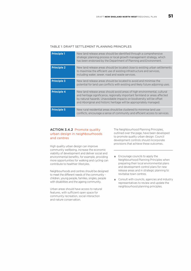
TABLE 1: DRAFT SETTLEMENT PLANNING PRINCIPLES
Principle 1 New land release areas should be identified through a comprehensive strategic planning process or local growth management strategy, which has been endorsed by the Department of Planning and Environment.
Principle 2 New land release areas should be located close to existing urban settlements to maximise the efficient use of existing infrastructure and services, including water, sewer, road and waste services.
Principle 3 New land release areas should be located to avoid and minimise the potential for land use conflicts with existing and likely future adjoining uses.
Principle 4 New land release areas should avoid areas of high environmental, cultural and heritage significance, regionally important farmland or areas affected by natural hazards. Unavoidable impacts on biodiversity will be offset and Aboriginal and historic heritage will be appropriately managed.
Principle 5 New rural residential areas should be clustered to minimise land use conflicts, encourage a sense of community and efficient access to services.
ACTION 3.4.2 Promote quality urban design in neighbourhoods and centres
High quality urban design can improve community wellbeing, increase the economic viability of development and deliver social and environmental benefits, for example, providing more opportunities for walking and cycling can contribute to healthier lifestyles.
Neighbourhoods and centres should be designed to meet the different needs of the community – children, young people, families, singles, people with disabilities and the ageing community.
Urban areas should have access to natural features, with sufficient open space for community recreation, social interaction and nature conservation.
The Neighbourhood Planning Principles, outlined over the page, have been developed to promote quality urban design. Council development controls should incorporate provisions that achieve these outcomes.
• Encourage councils to apply the Neighbourhood Planning Principles when preparing their local environmental plans and development control plans for new release areas and in strategic planning to revitalise town centres.
• Consult with councils, agencies and industry representatives to review and update the neighbourhood planning principles.
51DRAFT NEW ENGLAND NORTH WEST REGIONAL PLAN

ACTION 3.4.3 Encourage healthy living by increasing options for walking and cycling
Transport for NSW, in partnership with councils, has created a number of programs in centres to increase opportunities for people to be more active and therefore healthier. They include the Cycling Towns Program, Walking Communities Program, the Connecting Centres Cycling Program and NSW Bike Week.
These programs focus on:
• prioritising infrastructure improvements for two-kilometre walking catchments and five-kilometre cycling tracks that lead to town centres, as well as improving access to transport interchanges; and
• using information and events to promote walking and cycling as a form of transport.
• Work with councils to develop and implement programs that improve opportunities for walking and cycling.
DIRECTION 3.5 Increase access to health and education services
Together, the NSW and Commonwealth Governments have invested over $382 million to improve health services in the region over the last five years.26 This includes the redevelopment of Narrabri Hospital, the New England North West Regional Cancer Centre, the University of Newcastle’s Education Centre in Tamworth and the University of New England’s Tablelands Clinical Education Centre in Armidale. Tamworth Rural Referral Hospital has also been upgraded and Armidale Hospital will be upgraded by 2019.
The NSW Government is continuing to invest in the redevelopment and expansion of health services. The NSW Rural Health Plan aims to build healthy rural communities and reduce inequities between rural and metropolitan areas by providing access to high quality care and improving the integration of health services.
Campbell Park, Inverell
• Future growth is compatible with existing and potential land uses and community expectations for growth.
• Proposed development standards for growth areas reinforce positive aspects of the streetscape and adjoining development by promoting appropriate separation and scale.
• New residential development should respond to site characteristics such as topography and climate.
• Development should be designed to make sure there is public access to an adequate supply of appropriately located public open space and recreation areas, to provide for a range of recreational uses and visual amenity.
• Future growth considers the regional settlement hierarchy.
• Future growth areas will be located where they minimise potential adverse impacts on environmental and cultural heritage values and will avoid areas most affected by physical constraints such as flooding, bushfire or mine subsidence, or that have high cultural significance. Unavoidable impacts on biodiversity will be offset and Aboriginal and historic heritage will be appropriately managed.
• Future growth areas will have the capacity to promote energy efficiency and water sensitive urban design.
Neighbourhood Planning Principles
52

With an ageing population, the delivery of healthcare is likely to change. Health services will increasingly be delivered through the home or community-based ambulatory care services. Access to health facilities will still be necessary when clinically required.
The expansion of the mineral and energy resource, agriculture and food processing sectors will provide career and training opportunities across a number of fields. The region has leading education providers that are offering courses and pathway programs to help people pursue careers in these sectors.
The NSW Government is also investing in education infrastructure in the region which is based around the University of New England and TAFE New England. It is funding a $6.6 million upgrade to the Tamworth TAFE to provide community services, health, plumbing, facilities for people with disabilities, and an Indigenous Learning Centre. Upgrades to Moree East Public School and Narrabri Public School are also ongoing.
The Department of Planning and Environment will work with Transport for NSW to prioritise connections to health and education facilities when bus network planning is undertaken.
Providing more workplace learning and trade skills training by using or upgrading existing infrastructure is becoming more common. Funding from the Australian Government is providing opportunities to develop trade workshops or technical facilities that provide training in trade specialities that are important to the region’s economic growth, including engineering, primary industries and hospitality.
The NSW Government’s Smart and Skilled program will help the region’s residents improve their skills and gain employment.
ACTION 3.5.1 Realign health services to the needs of the community
A number of health facilities across the region are expected to realign their services in response to the changing health needs of the population. Multipurpose health facilities may help to provide integrated health and aged care services outside of hospitals.
• Identify capacity for health facilities to align their functions and services in response to the changing health needs of the community.
ACTION 3.5.2 Facilitate planning for additional primary and secondary school places
The Department of Education and Communities is preparing a long term strategic plan to 2031, as well as regional plans and school cluster plans to respond to changing demands across the State.
By 2031, there are expected to be around 450 more primary school places and 300 more high school places in public schools in the New England North West.27 The projected growth in the number of school-age children is likely to be accommodated in existing schools. The Department will monitor changes in demand in all the region’s public schools over time and plan for additional school places as required.
Private schools are also important contributors to primary and secondary education and will continue to provide services throughout the New England North West.
• Continue to develop a revised service model and approach to school asset planning.
• Monitor the rate and uptake of development in centres and new release areas to respond to increased school enrolments.
53DRAFT NEW ENGLAND NORTH WEST REGIONAL PLAN

ACTION 3.6.2 Monitor development activity to support infrastructure planning
The New England North West Housing and Land Monitor was introduced to monitor housing, jobs and infrastructure delivery. It provides information about the rate at which land is being developed and the nature of housing approvals across the region on an annual basis. This information will be used to adjust infrastructure and service priorities to match changing growth patterns.
• Continue to monitor development activity and regularly report on growth across the region.
DIRECTION 3.6 Coordinate infrastructure delivery
New development will be located to maximise the use of existing infrastructure and leverage the capacity to cost-effectively extend services. Proposed new land releases and development should demonstrate how they will be supported by existing infrastructure or how new infrastructure can be provided and funded, prior to approval.
The NSW Government will support councils and infrastructure and utility providers to identify appropriate sites and capacity to provide for future needs, including water security, wastewater service capacity, electricity supply, emergency service facilities, cemeteries and crematoria.
ACTION 3.6.1 Coordinate urban growth and infrastructure delivery
Councils should undertake detailed infrastructure service planning to establish that land can be feasibly and economically serviced, prior to rezoning. This will support the timely release and development of land. Councils should also undertake detailed design investigations and analyse the infrastructure requirements associated with rezoning proposals.
• Support the work of councils to complete detailed infrastructure plans to support new land release.
Left: Narrabri District Health ServiceRight: Train Station, Tamworth

Water infrastructure
Groundwater and bulk storages are used for agriculture and town water supplies and maintaining a secure yield is a priority for the region. The NSW Government’s Water Security for Regions program, part of the Restart NSW fund, has been set up to improve water security. Under Water Security for Regions, $366 million has been reserved to help communities prepare for future drought conditions. Dam augmentation, pipeline and bore works and water efficiency mechanisms are being funded to help farmers and regional industries deal with drier conditions.
A number of projects have been undertaken in the region, including the Glen Innes Off Stream Storage project, Wallabadah Bore and Pipe project (Liverpool Plains), Willow Tree Pipeline project (Liverpool Plains), and Baa Baa Water Supply Provision project (Narrabri Shire).
Current bulk water supplies can support the forecast town water supply to 2036. Dam safety upgrades are under way or have recently been completed at Chaffey, Keepit, Split Rock and Copeton.
Electricity infrastructure
Energy providers need to understand development activity across the region to undertake their service planning. Early engagement between mining and renewable energy companies and the operators of the transmission/distribution network will reduce long lead-in times for planning.
TransGrid has identified short term constraints for the 132 kV transmission system supplying the Gunnedah, Narrabri and Moree areas, however, options to resolve these constraints are being considered. TransGrid has commenced construction of a new substation in Tamworth, which is a major investment into the reliability and efficiency of current and future supply for homes and industries.
The northern NSW supply system has also been identified as a longer term supply constraint and the region is projected to exceed transmission capacity. As part of the Northern Telecommunications Link Project, TransGrid will connect communication systems to the North Coast to meet regulatory requirements and to maintain a reliable electricity supply for northern NSW.
In recent years, Essential Energy has completed upgrades to zone substations at Armidale, Inverell and Tamworth to secure predicted electricity demand. The existing electricity distribution network will meet forecast electricity demand across the region to 2036.
55DRAFT NEW ENGLAND NORTH WEST REGIONAL PLAN


GOAL 4 – Prosperous urban centres with job opportunities
Over the last century, the region’s population has become increasingly concentrated in the larger urban centres, primarily as a result of agricultural restructuring, mechanisation and changes in labour markets. This trend is likely to continue.
The two regional cities, Tamworth and Armidale, are projected to support over half the region’s population by 2036 and their development will help to drive growth for the region. A further 28 per cent of the population is projected to reside in the four strategic centres of Inverell, Narrabri, Gunnedah and Moree,28 which provide a range of employment opportunities and services to their communities and to other adjoining centres.
Efficient transport networks will support economic activity and more local job opportunities in centres. The growth of mining services and agriculture-related industries will also drive demand for additional industrial land and commercial opportunities in centres. An ongoing supply of industrial and commercial land for development, which is not constrained by adjoining land uses or access to infrastructure, is essential to grow jobs.
The draft Plan:
• identifies planning controls and infrastructure to support the delivery of new housing and job opportunities that will facilitate the growth of Tamworth and Armidale;
• improves linkages across the region and inter-regionally by investigating options for improved road and transport connections;
• secures adequate supplies of land to support jobs by prioritising infrastructure planning and delivery for industrial and commercial land;
• reinforces the vitality and viability of commercial centres;
• grows tourism employment opportunities; and
• acknowledges the importance of education and agricultural research facilities.
DIRECTION 4.1 Grow the regional cities of Tamworth and Armidale
The regional cities of Tamworth and Armidale provide access to State and regional services, higher-order retailing, major health and education facilities, and industry and related employment for the region. These services and facilities will continue to generate population and employment growth.
Tamworth is particularly influential and provides high-level services and facilities that are used by residents across the New England North West. Around one in three of the region’s houses and jobs are located in this local government area.29
Armidale provides a range of services for the New England district, with 17.4 per cent of the region’s jobs30 in 2011 and a 16 per cent share of the gross regional product in 2013-14.31
Top: Peel Street, Tamworth
Centre: Balo Street, Moree
Bottom: Beardy Street, Armidale
57DRAFT NEW ENGLAND NORTH WEST REGIONAL PLAN

services and opportunities they offer. These major institutions create employment and research nodes and include the recently redeveloped Tamworth Base Hospital, the Armidale Rural Referral Hospital which is currently being upgraded, the University of New England, and TAFE New England.
Encouraging the clustering of complementary activities in these precincts will drive employment and economic growth in the region.
Figures 13 and 14 illustrate the location of growth precincts and the areas where future growth is projected for Tamworth and Armidale.
Armidale has the highest concentration of people employed in education and training in the region, with 2,144 people employed in the sector.32 As an education hub, there are significant future growth opportunities associated with the expanding education export sector.
Tamworth and Armidale have growth precincts (see Figure 12) that contribute to the wider regional economy and influence the region through the services and opportunities they provide. These precincts are based around a number of major institutions which are anchors for economic growth and new jobs, due to the
TABLE 2: TAMWORTH AND ARMIDALE – SHARE OF POPULATION, HOUSING AND JOBS IN THE REGION
TAMWORTH ARMIDALE
Share of regional population 201133 31.9% 16.2%
Share of regional population 203634 35.1% 19.1%
Share of regional housing 201135 30.5% 15.5%
Share of regional housing 203636 33.8% 18.2%
Share of jobs 201137 33.2% 17.4%
Share of Gross Regional Product 2013–1438 32.2% 16%
Business &ServiceCentres
AirportPrecincts
EducationPrecincts
HealthPrecincts
ResidentialRelease
Areas
RuralResidential
ReleaseAreas
EmploymentLands
FIGURE 12: GROWTH PRECINCTS
Tamworth Rural Referral Hospital
58

• Identify opportunities to accelerate housing supply in land release areas to support projected population growth.
• Identify opportunities to improve transport connectivity to other settlements and markets.
• Update planning strategies and policies relevant to regional needs.
DIRECTION 4.2 Enhance access to jobs, goods and services by improving connections between centres
Having reliable transport connections within and between settlements improves access to health services, education and job opportunities.
The NSW Government has invested over $65 million in the last five years to improve the connectivity of the region’s local and State roads.40 This has increased the efficiency of road movements and helped to reduce local congestion.
The passenger rail network provides services to regional cities and strategic centres, connecting Moree, Narrabri, Gunnedah, Armidale and Tamworth to Newcastle and Sydney on a daily basis. The bus and coach networks also provide regional connections between urban centres, Sydney, Newcastle and Brisbane.
The regional airports are experiencing increasing domestic and business air travel. In 2014, Tamworth, Armidale and Moree airports handled over 310,000 passenger movements with Sydney Airport.41 Daily flights to Brisbane are also available. The airports provide services for fly-in fly-out workers and access to specialist health, education and commercial facilities. The expansion of mining activities will place increasing demands on the region’s airports. Growth opportunities also exist in association with airports located outside the region, such as the Brisbane West Wellcamp Airport (Toowoomba), to improve agricultural freight movement and access the rapidly growing Asian market.
Case Study: Armidale Airport Master Plan39
Armidale Regional Council is developing an Airport Master Plan for their airport precinct. To date, the precinct has focused on aviation-related activities. Land outside the airspace protection zone offers major development potential for tourism and residential development associated with private aviation and commercial development, including an airport hotel and highway service centre.
Approximately 14 hectares of industrial zoned land is available in Stage 1 for aviation-related activities and commercial development and a further 5.5 hectares of business zoned land for an airport hotel, museums, highway service centre and visitor information centre. A further 8.5 hectares is proposed for development of a residential air-park, offering combined residential housing and aircraft storage.
ACTION 4.1.1 Work with Tamworth and Armidale Regional Councils to provide opportunities for increased jobs, services and housing
The growth of Tamworth and Armidale will strengthen the region’s economy. Residential release areas in these regional cities will deliver the majority of new housing that will be required in the region to support projected population growth. Additional housing in and around business and service centres, new land releases for urban housing and rural residential uses, and land for industry, commercial and retail development will be needed to support population and economic growth and change in these regional cities.
• Deliver strategies that strengthen the role, vitality and vibrancy of commercial centres and potential employment nodes.
• Identify infrastructure that supports growth, including the activation of health, education and aviation precincts.
59DRAFT NEW ENGLAND NORTH WEST REGIONAL PLAN

FIGURE 13: TAMWORTH GROWTH PRECINCTS
City Centre
Health Precinct
Education Precinct
Airport Precinct
Regional Sports and Entertainment Precinct
Key Transport Connections
Railway
Industrial/Employment Area
Future IndustrialInvestigation Area
Commercial Core
Commercial/Business Area
Future BusinessInvestigation AreaDeveloping Commercial/ Business Area or Business Park
Existing Residential Area
Developing Residential Area
Future ResidentialInvestigation AreaExisting Large LotResidential AreaFuture Large Lot Residential Investigation Area
National Park and Reserve
Waterway

FIGURE 14: ARMIDALE GROWTH PRECINCTS
City Centre
Health Precinct
Education Precinct
Airport Precinct
Key Transport Connections
Railway
Industrial/Employment Area
Future IndustrialInvestigation Area
Commercial Core
Commercial/Business Area
Existing Residential Area
Future ResidentialInvestigation AreaExisting Large LotResidential AreaFuture Large Lot Residential Investigation Area
National Park and Reserve
Waterway

ACTION 4.2.2 Deliver improved transport connectivity for urban centres
Integrating community transport services into the public transport system will improve connections between centres and communities across the region. The NSW Government currently funds several community transport programs for people living in regional areas including the:
• Community Transport Program;
• Regional Transport Coordination Program;
• Country Passenger Transport Infrastructure Grants Scheme; and
• Commonwealth Home Support Program (an Australian Government initiative).
The New England North West Regional Transport Plan (2013) identified that the region will receive a share of the $389 million to support and improve rural and regional bus services. Transport for NSW will work with bus operators in the region to develop routes and timetables to improve services.
• Investigate further opportunities to improve bus operations in urban centres and their connections with regional communities.
ACTION 4.2.3 Minimise the impact of development on the efficiency of the transport network
Limiting inappropriate development along existing and proposed bypasses, and ribbon development along highways, will minimise the potential effects of development on the efficiency of the transport network. It will also protect the productivity and safety improvements from the investment in bypasses and highway upgrades.
• Identify buffer measures in local environmental plans for heavy vehicle bypasses around urban centres.
• Limit ribbon development along the region’s key transport routes.
The NSW Government does not support changes to the protections for existing regional flights to Sydney Airport. It is aiming to preserve current regular passenger transport services to Sydney Airport. Ongoing access for the regional airlines to Sydney Airport and the nearby CBD is important for regional communities, as well as providing transfers to interstate and overseas destinations. Transport for NSW licences routes that operate with less than 50,000 passengers per annum, for example, Narrabri and Moree.42 These licences grant exclusive rights of operation on the route for the term of the licence until 2018. Ensuring ongoing access to the rapidly expanding South East Queensland region via Brisbane Airport, will also provide important economic and social links for the region.
ACTION 4.2.1 Identify connectivity improvements for key State roads in the region
Transport for NSW and Roads and Maritime Services are progressively preparing network and corridor strategies to cover every State road in NSW to better manage transport infrastructure and maximise benefits for all road users. The corridor strategies will set a 20-year framework, which brings road safety, traffic efficiency and asset management activities together with freight access policy.
Network and corridor strategies provide the following benefits for the State road network:
• a plan for improvement that considers all modes of transport;
• transparency for the community and councils about planning and investment decisions;
• consistency in planning, management and the operation of roads; and
• the integration of road safety, traffic and asset maintenance projects.
The Newell Highway Corridor Strategy (2015) outlines the investment priorities to develop, manage and maintain the Newell Highway. The New England Highway Corridor Strategy is also being prepared.
• Progressively prepare corridor strategies for State roads in the region.
Tamworth Railway Station
62

0
200
400
600
800
1000
1200
1400
1600
Arm
idal
e R
egio
nal
Gle
n In
nes
Seve
rn
Gun
ned
ah
Gw
ydir
Inve
rell
Live
rpo
ol P
lain
s
Mo
ree
Pla
ins
Nar
rab
ri
Tam
wo
rth
Reg
iona
l
Tent
erfi
eld
Ura
lla
Wal
cha
Hec
tacr
es
Developed Industrial LandRemaining Vacant Industrial Land
Better monitoring of relevant industrial and employment land supply in the region is needed as well as forecasting when new industrial and employment land will be required and where it should be located.
Councils should identify and maintain an adequate supply of zoned industrial and employment land in planning strategies and local environmental plans which is:
• capable of being developed due to minimal environmental constraints;
• supported by strong transport links to markets and workers;
• unlikely to be affected by land use conflict with adjoining uses;
• capable of being cost-effectively provided with any necessary services and infrastructure; and
• able to meet changing employment needs.
Existing and future industrial and employment lands need to be protected from the encroachment of incompatible land uses.
DIRECTION 4.3 Provide well-located and serviced supplies of industrial and employment lands
Industrial and employment land plays a critical role in the regional economy by providing space for local job opportunities across a range of industries – including mining, agriculture and food processing – through to small-scale engineering and processing firms.
Well-located and well-serviced industrial and employment land can help to drive employment potential and support existing and emerging industries. The availability of industrial and employment land varies greatly across the region. Overall, there is sufficient supply of industrial land to accommodate projected growth in the region for the next 20 years. However, some locations have limited surplus and will need further investigation (see Figure 15).
FIGURE 15: AVAILABILITY OF INDUSTRIAL LAND BY LOCAL GOVERNMENT AREA IN 2012–13
Source: Department of Planning and Environment 2016, New England North West Housing and Land Monitor
63DRAFT NEW ENGLAND NORTH WEST REGIONAL PLAN

Some developments may need to be located away from traditional mixed use industrial areas and into specialised precincts due to their type, scale and nature, for example, concrete batching plants, bitumen works, food processing facilities, research facilities and other activities that may have special needs as the economy changes and evolves and as employment nodes develop.
ACTION 4.3.1 Secure a supply of relevant industrial and employment lands to support employment growth
The NSW Government’s New England North West Housing and Land Monitor provides information on industrial land supply in each local government area and indicates the rate at which industrial land is being developed on an annual basis. It is produced with council input.
The supply of land can be restricted at times by the economic cost of road, drainage, water, sewer, gas, and electricity infrastructure. There may be increases in demand in some urban areas in the region because of the expansion of manufacturing, mining and agricultural and food processing industries. The Government may need to work with stakeholders to accelerate supply in regionally significant industrial areas.
Planning for freight access should be undertaken when identifying new industrial areas. Industrial release areas should be located in close proximity to the Restricted Access Vehicle Network and have efficient access to a serving railhead where available.
Case Study: Glen Artney Industrial Estate at Tamworth
The Glen Artney Industrial Estate is approximately 600 hectares in size and is located about seven kilometres west of the Tamworth Central Business District, adjacent to the Tamworth Regional Airport. The estate accommodates a wide range of uses including abattoirs, manufacturing, transport/logistics and service industries.
Tamworth Regional Council prepared the Glen Artney Development Strategy in 2008 to consider site constraints, infrastructure issues and opportunities for the ongoing provision of employment land. The strategy has helped to provide employment land to support new and existing employment opportunities in Tamworth.
• Monitor industrial development activity for each local government area through the New England North West Housing and Land Monitor.
• Prepare Statewide land release criteria to assess locations for industrial uses across regional NSW to be used in settlement planning.
• Work with councils and servicing agencies to prioritise infrastructure planning and delivery for employment and commercial lands.
TamindaIndustrial Estate, Tamworth
64

DIRECTION 4.4 Enhance the viability and vitality of commercial centres
Considerable investment in social, economic and transport infrastructure has been made in the commercial centres of existing settlements. Centres can contribute to the quality of life of residents and create a sense of place and community identity. They are also an important source of economic diversity and employment.
Traditional commercial centres are facing challenges due to the growth of online and bulky goods retailing, and from declining discretionary retail spending on non-food and beverage goods over the last 20 years. Centres need to adapt to remain vibrant and capable of delivering their important commercial functions and to provide community and social benefits.
Focusing major commercial activities such as shops, offices, banks and government services in town centres or existing commercial zones strengthens the role, vitality and vibrancy of centres.
Opportunities for residents to live and work in and around town centres and main streets can be made available in the form of shop top housing, villas and townhouses.
ACTION 4.4.1 Encourage retail and commercial uses in main streets and town centres to enhance the vitality and viability of these areas
It is important to support retail and business activity in existing commercial centres with sufficient zoned and appropriately located land. Councils should regularly review their retail commercial land supply in areas experiencing population growth to plan for sufficient zoned land.
Where it is not possible to expand or accommodate growth in existing centres, or where there is significant market demand, councils may need to consider new centres of an appropriate size and scale.
Proposals for new centres (including retail proposals) will need to demonstrate how they:
• respond to retail supply and demand;
• respond to innovations in the retail sector; and
• maximise the use of existing infrastructure (including public transport and community facilities) commensurate with the scale of the proposal.
The net community benefit should be a factor when assessing these proposals.
• Focus new retail areas in existing commercial centres, unless there is a demonstrated need and positive social and economic benefits for the community.
Case Study: Glen Innes Town Centre Master Plan
Glen Innes Severn Council has made significant investments in the Glen Innes Town Centre to support a vibrant retail and commercial centre and encourage urban activation and investment.
In 2011, the Council adopted a Central Business District (CBD) Master Plan which proposed a $2.2 million investment to improve pedestrian safety, upgrade street lighting and create a town square shared zone and street tree planting.
In 2012, the Council received $1.8 million as a loan from the NSW Government Local Infrastructure Renewal Scheme to enable the works proposed under the Master Plan to be completed in a shorter timeframe.
Work on the CBD revitalisation began in 2013, and is being carried out in stages.
65DRAFT NEW ENGLAND NORTH WEST REGIONAL PLAN


Top:Oxley Scenic Lookout, Tamworth
Middle:Maitland Street, Narrabri
Bottom: Rotary Park, Tenterfield
DIRECTION 4.5 Grow tourism to support employment opportunities and urban centres
Tourism is an important contributor to the region’s economy. In 2015, there were over 1.2 million domestic and international overnight visitors to the region43 and they contributed over $740 million to the economy.44 This represented the highest tourism expenditure in inland NSW.
The New England North West has an array of tourism attractions and experiences that support economic activity and employment opportunities, including:
• bushwalking and birdwatching in World Heritage Areas, such as the Washpool, Gibraltar, Oxley Wild Rivers and the Werrikimbe National Parks;
• nationally significant Aboriginal cultural sites, such as the Myall Creek Massacre and Memorial site;
• important heritage buildings, such as the Anglican and Catholic cathedrals in Armidale;
• world-class events and conference facilities, such as the Australian Equine and Livestock Events Centre and the Tamworth Regional Entertainment and Conference Centre;
• internationally recognised events and festivals, such as the Tamworth Country Music Festival and AgQuip Field Days at Gunnedah;
• fossicking in the local waterways around Uralla, Glen Innes and Inverell;
• driving and cycling day trips to local wineries, farm gates and local produce suppliers;
• world-class hang-gliding around Manilla; and
• hot artesian waters in and around Moree.
Good transport connections and the region’s proximity to larger settlements in South East Queensland, the Hunter, North Coast and Sydney, provide opportunities to develop and build diversity in the economy by growing the tourism sector. Tourism-related transport services, such as festival bus services and park and ride services, will be considered through the development of annual servicing plans for major events, as outlined in the New England North West Regional Transport Plan (2013).
ACTION 4.5.1 Facilitate opportunities for a range of tourist experiences and accommodation
The NSW Government will work with councils to plan for a range of tourist experiences and accommodation. This includes providing scope for complementary land uses, and infrastructure and services that support and build on existing and emerging tourist attractions across the region. This can be done by:
• providing flexible planning controls to facilitate a range of tourist accommodation options, such as farm stay and bed and breakfast developments;
• enabling a diverse range of cultural heritage tourism, including opportunities to engage with Aboriginal communities and their culture; and
• supporting the development of complementary tourism experiences associated with agriculture.
• Planning strategies and local environmental plans to provide land and opportunities to support tourist experiences and accommodation.
67DRAFT NEW ENGLAND NORTH WEST REGIONAL PLAN
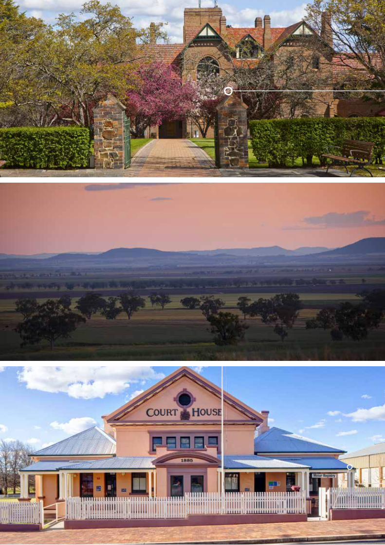

GOAL 5 – Protected water, environment and heritage
The New England North West has a wealth of environmental and heritage assets that underpin the economy and create a unique lifestyle for residents and visitors.
The region boasts diverse landscapes, including rainforest covered volcanic plateaus and escarpments, alpine communities on the Great Dividing Range, remnant inland forests, wetlands of national and international significance and a variety of grasslands and forest ecosystems. These landscapes and their remnant vegetation provide important habitat for threatened flora and fauna species.
Healthy ecosystems are better able to recover from drought, pests, wildfire and climate change, support the economic prosperity of agriculture and tourism, and contribute to community health and wellbeing. The natural environment is important to the identity, spirituality and resource base of the region’s Aboriginal peoples. Growth needs to be managed sustainably to protect environmental and heritage values for current and future generations.
Water catchments and groundwater aquifers provide water for urban areas, agriculture and industry, and they help to sustain the environment, economy and lifestyles. Protecting water quality, managing access to water supplies and managing activities that interrupt natural ecological processes are essential for the health of water catchments and to support population and economic growth.
The NSW Government recognises the conservation, social and economic values of the region’s environment, heritage and water catchments, and the importance of managing them sustainably. A holistic management approach is required to maximise productive capacity, while preserving environmental and heritage values.
The draft Plan:
• protects water catchments, waterways and riparian lands to secure long term water quality, biodiversity, recreation and economic outcomes;
• identifies and protects areas of high environmental and heritage value; and
• promotes adaptation to climate change and natural hazards.
DIRECTION 5.1 Manage water resources for a growing economy and environmental sustainability
The majority of the region is located in the Murray-Darling Basin. The main river systems are the Namoi, Gwydir and Macintyre and the upper reaches of the coastal river systems of the Clarence, Macleay and Manning Rivers (see Figure 16). The main sources of groundwater are the Great Artesian Basin and various alluvial aquifers. The region also contains some major floodplain wetlands, including the internationally significant Gwydir Wetlands (Gingham and Lower Gwydir [Big Leather] waterways) and Little Llangothlin Lagoon.
Water is a limited resource and must be carefully managed. Groundwater and surface water are vulnerable to the pressures of urban growth, increasing climate variability and growing agricultural and natural resource needs. Water extraction from rivers contributes to economic prosperity; however, too much extraction may severely affect aquatic ecosystems, especially during periods of low river flows.
Top: Booloominbah, University of New England, Armidale
Centre: Liverpool Plains
Bottom: Historic Tenterfield Courthouse
69DRAFT NEW ENGLAND NORTH WEST REGIONAL PLAN

opportunities to trade water. The Department will develop water sharing plans, in accordance with the Murray-Darling Basin Plan, for all major river and groundwater systems.
Access to water and favourable soil conditions have helped the agricultural sector to grow and prosper. The scale of potential changes in the region from water trading and sharing associated with the Basin Plan is not yet fully understood. By monitoring the impacts of these changes, the effects on river health, agricultural land use and settlements will be better understood.
• Finalise water sharing plans in accordance with the Murray Darling Basin Plan for rivers and groundwater systems.
• Investigate ways of monitoring the long term impacts of water sharing and trading on river health, agricultural land use and settlements.
ACTION 5.1.2 Identify measures to improve the efficient use of water
The Rebuilding NSW – State Infrastructure Strategy (2014) identified the Gwydir catchment as a high priority for the $1 billion Regional Water Security and Supply Fund due to its low drought security and the low water delivery efficiency of existing infrastructure. The NSW Government will investigate projects that deliver the most efficient and sustainable outcomes in the Gwydir catchment.
Many farms rely on dams and onsite water storages to undertake routine agricultural activities. Poorly built farm dams can be structurally unstable, have inadequate compaction, use unsuitable soil types or are too shallow. This can lead to dam failure and unnecessarily high water loss. With climate change and limited water resources it is important that dams and onsite water storages are constructed to best practice standards.
The NSW Department of Primary Industries manages water access and licences, however some dams and onsite water storages may not require a licence depending on the ‘maximum harvestable right dam capacity’, which takes into account rainfall and variations in rainfall pattern.
Water for irrigation is sourced from regulated river systems (water released from large river dams), groundwater production bores and unregulated river and overland flows captured or pumped into on-farm storages. These sources are particularly important for irrigated cotton around Moree and Narrabri. Groundwater and surface water support the livestock sector.
Responding to changes in water allocation and climate change will be a major challenge for the region. Improving water use efficiency will help to maximise this limited resource and support the ongoing growth of the economy.
Councils have an important role in improving water efficiency through water sensitive urban design and planning controls that avoid or mitigate impacts of development on drinking water catchments.
Water Management in the New England North West
The Murray-Darling Basin Plan (2012) guides water resource management in the Murray–Darling Basin. The Basin Plan outlines the water that must be returned from each catchment to meet environmental needs.
The Department of Primary Industries, Water is recovering water in the Great Artesian Basin by capping and piping free-flowing artesian bores. The Cap and Pipe the Bores Program provides landholders in the Great Artesian Basin with financial incentives to cap and pipe their bores. This increases artesian pressure, while establishing reliable and efficient supplies of good quality water to properties across the North West.
ACTION 5.1.1 Manage water access and trading across the region
The Department of Primary Industries’ water sharing plans establish important water access, trading and accounting rules. They affect the type of licences required, the entitlement, and the source of the water. The plans protect the health of rivers and groundwater while providing water users with perpetual access licences, equitable conditions and increased
Keepit Dam spillway, near Gunnedah, courtesy of WaterNSW
70

Regional City
Strategic Centre
Centre
Gwydir
Macintyre-Dumaresq
Namoi
Clarence
Macleay
Manning
Hastings
River Direction Flow
FIGURE 16: NEW ENGLAND NORTH WEST RIVER CATCHMENTS
71DRAFT NEW ENGLAND NORTH WEST REGIONAL PLAN

Water Sensitive Urban Design45
Water sensitive urban design techniques can be incorporated into homes, streets, parking areas, subdivisions and multi-unit, commercial and industrial developments, and public land. The techniques include:
• permeable paving of footpaths, common areas and parking spaces above underground water storage facilities;
• water-efficient fittings and appliances;
• maintaining fixtures (for example, stopping leaks and drips from plumbing and taps);
• green roofs and living walls (that is, planting on roofs and down walls);
• appropriate landscaping (for example, efficient irrigation, mulching, wind and sun protection, minimising lawn area and selection of suitable plants);
• wetlands to capture and treat run-off water;
• capture and storage of rainwater and stormwater for residential re-use, or to irrigate parks, sporting fields and other open space; and
• capture, treatment and re-use of wastewater.
Improving the water efficiency of buildings in urban areas can help to extend the life and reliability of water supplies. Councils should promote water sensitive urban design techniques to improve water use planning, efficiency and supply. Councils can also apply water sensitive urban design through wastewater re-use, for example, by substituting water currently used for watering parks and reserves or to supplement agricultural uses near settlements.
• Investigate projects that will deliver the most efficient and sustainable outcomes in the Gwydir catchment.
• Work with councils to prepare construction guidelines for dams that do not need a licence.
• Encourage councils to incorporate water sensitive urban design in new land release areas.
• Encourage councils to use alternate water sources on local government assets such as playing fields.
Aspley Falls, Walcha, courtesy of Office of Environment and Heritage
ACTION 5.1.3 Maintain healthy waterways and wetlands, including downstream environments
Water quality influences the ability of waterways and aquifers to sustain healthy aquatic ecosystems. The NSW Government’s Water Quality and River Flow Objectives represent the agreed environmental values and long term goals for the State’s waterways. Councils can use them as a resource in their catchment and local strategic plans to achieve healthy waterways.
New development will be located to minimise impacts on aquatic habitats, such as waterways and wetlands, including potential downstream impacts. The Department of Primary Industries’ Guidelines for Fish Habitat Conservation and Management outline how to maintain and enhance fish habitat. Additionally, the Controlled Activities on Waterfront Land – Guidelines for riparian corridors on waterfront land (2012) outline the requirements to ensure no more than minimal harm is done to waterfront land as a result of carrying out a controlled activity.46
• Use appropriate provisions to protect water catchment areas and groundwater sources from the potential effects of development. (Any development should have a neutral or beneficial effect on water quality).
• Minimise the impacts of development on fish habitat, aquaculture and waterways (including watercourses, wetlands and riparian lands) and meet the Water Quality and River Flow Objectives.
DIRECTION 5.2 Protect areas of high environmental value
The region has unique environmental values. Around 882,000 hectares, or 9 per cent of the region, is protected in the public reserve system.47 This permanently conserves the land and protects areas of natural and cultural heritage significance to Aboriginal people.
The Office of Environment and Heritage has mapped areas of potential high environmental value in the region (see Figure 17).
72

TABLE 3: NEW ENGLAND NORTH WEST RESERVE SYSTEM48
Reserve Hectares
National Parks 622,794
Nature Reserves 84,185
State Conservation Areas 153,643
Aboriginal Areas 21,179
World Heritage Areas 152,455
ACTION 5.2.1 Protect areas of high environmental value
Many of the region’s natural features and environmental values are already protected through existing legislation. The potential high environmental values map (Figure 17) can be used to inform council planning strategies and local environmental plans and to consider opportunities for biodiversity certification for areas of high environmental value.
Groundwater-dependent ecosystems and aquatic habitats also have high environmental values. Maps identifying fish community status, aquatic threatened species distribution and key fish habitat are available from the Department of Primary Industries, Fisheries.
• Work with councils, when they are preparing planning strategies or local environmental plans for new or more intensive development to:
identify and implement appropriate planning controls to protect areas of high environmental value;
implement the ‘avoid, minimise, offset’ hierarchy, by striving to avoid and minimise impacts on areas of high environmental value, and where impacts cannot be avoided, identify and secure appropriate biodiversity offsets through an offset strategy; and
consider the use of biodiversity certification.
• Continue to refine the potential high environmental values mapping as new information arises.
This mapping shows regionally important conservation and habitat areas and the potential location of biodiversity offset areas. It is a useful tool if a new development is likely to have an environmental impact that cannot be avoided or mitigated and a biodiversity offset is considered. Mapping will be routinely updated as better information becomes available.
Some areas not identified on the map, including terrestrial and aquatic environments, may also contain high environmental values.
The data used to identify high environmental values in this draft Plan is intended to provide a regional-level overview for the purposes of strategic planning. This data will continue to be updated as new information becomes available. Planning authorities should contact the Office of Environment and Heritage to obtain the most recent spatial data.
The future legislative and policy framework for biodiversity conservation and native vegetation management in New South Wales will be guided by the outcomes of the biodiversity legislation review.
Explanatory Note: High Environmental Values map
A range of criteria was used to map high environmental values land including:
• existing conservation areas, including national parks and reserves, declared wilderness areas, Crown reserves dedicated for environmental protection and conservation, and flora reserves;
• native vegetation of high conservation value, including vegetation types that have been over-cleared or occur within over-cleared landscapes, old growth forests and rainforests;
• threatened ecological communities and key habitats;
• important wetlands and lakes; and
• sites of geological significance.
73DRAFT NEW ENGLAND NORTH WEST REGIONAL PLAN

Regional City
Strategic Centre
Centre
Local Government Area
Highway
Main Road
Railway
Ramsar Wetland
Potential High Environmental Values
World Heritage Area
National Park and Reserve
State Forest
Wetlands
Waterway
FIGURE 17: AREAS OF POTENTIAL HIGH ENVIRONMENTAL VALUE
74


Town Hall, Glen Innes
DIRECTION 5.3 Protect Aboriginal and historic heritage
The region has significant Aboriginal and historic heritage assets. The State Heritage Inventory contains 65 items listed under the Heritage Act 1977 and 1,315 items listed by councils and State agencies, including iconic sites such as Thunderbolt’s Grave, the Myall Creek Massacre and Memorial Site and St Peters Anglican Cathedral at Armidale.49 Aboriginal and historic heritage items are generally protected by the National Parks and Wildlife Act 1974, the Heritage Act 1977 or local environmental plans.
Aboriginal cultural heritage includes places and objects that are of significance to Aboriginal people because of their traditions, observances, lore, customs, beliefs and history. It is dynamic and may comprise physical (tangible) or non-physical (intangible) elements. Aboriginal cultural heritage also relates to the connection and sense of belonging that people have with the landscape and with each other.
It is likely that objects and sites of Aboriginal heritage significance in the region are under-recorded, which makes them more vulnerable to accidental damage or destruction and consequently improper conservation management. This is particularly the case for sites associated with pre-contact habitation and usage, burial sites, battle sites and camping, hunting and fishing sites.
ACTION 5.3.1 Identify and, where appropriate, map areas of Aboriginal and historic heritage in new land release areas
The Office of Environment and Heritage will review proposals for new land release to identify Aboriginal and historic heritage issues, and their advice will be used to inform council planning strategies and local environmental plans.
Local places and objects and items of Aboriginal and historic heritage should be identified, protected and preserved. Local cultural heritage studies should be prepared in consultation with local communities, to identify places of Aboriginal and historic heritage significance. Where impacts on
ACTION 5.2.2 Identify areas of potential high environmental value in new land release areas
The areas of potential high environmental value map has been produced at the regional-scale to provide general strategic guidance. Areas proposed for urban release will need further detailed, site-based studies to identify areas of natural and cultural significance.
The Office of Environment and Heritage will review proposals for new urban development to identify significant environmental issues that may constrain development. Their advice will also be used to consider opportunities for biodiversity certification and to inform council planning strategies and local environmental plans.
• Review proposals for new land release to identify areas of potential high environmental value.
• Assist councils to achieve biodiversity certification and identify any potential offset requirements in new land release areas.
Biodiversity Certification
Conservation planning tools can help proponents, communities and decision-makers protect or manage biodiversity that is subject to development pressure.
Biodiversity certification offers planning authorities a streamlined biodiversity assessment process for areas marked for development at the strategic planning stage. The process identifies areas of high conservation value at a landscape scale. These areas can be avoided and protected while identifying areas suitable for development.
Biodiversity certification offers a range of secure options for offsetting impacts on biodiversity, including aquatic biodiversity protected under the Fisheries Management Act 1994.
76

Aboriginal and historic heritage from agriculture, natural resource development and urban and rural residential development cannot be avoided, appropriate heritage management mechanisms should be implemented.
• Provide information, where available, to identify sites, objects and items of potential Aboriginal and historic heritage in areas proposed for new land release.
• Encourage councils to review or prepare local cultural heritage studies to identify and protect sites, objects and items of Aboriginal and historic heritage significance when preparing planning strategies or local environmental plans, and appropriately manage any unavoidable impacts from development.
ACTION 5.3.2 Identify appropriate and innovative opportunities to preserve heritage assets
Adaptive or sympathetic use of heritage items can give them a new purpose and promote heritage conservation and appreciation. Where impacts from new development near heritage items and areas cannot be avoided, proposals that reduce any impacts through sympathetic design should be developed in accordance with relevant statutory processes.
• Encourage councils to regularly review and update their planning controls and heritage studies so that opportunities for the adaptive or sympathetic use of heritage items are promoted and available.
DIRECTION 5.4 Adapt to natural hazards and climate change
The potential impacts of climate change will be a major challenge for the region. The NSW Climate Impact Profile (2010) forecasts increased temperatures, more hot days, fewer cold nights and decreased winter rainfall by 2050. This is expected to increase the risk and severity of natural hazards.
Planning strategies need to reflect and respond to the potential risks of climate change. Local environmental plans, development control plans and council planning strategies can do this in a number of ways, including:
• providing controls that allow for innovation in farming practices and new emerging industries as a result of climate change;
• creating more liveable conditions by developing building standards and urban design approaches that create resilient environments for the future such as thermal efficient building designs and creating greenways; and
• introducing policies that permit large-scale renewable energy projects.
Projected climatic changes in the New England North West50
Maximum temperatures in the region are projected to increase by 0.4 to 1 degree in the near future (from 2020 to 2039). The greatest maximum temperature increase is projected for the North West, which will experience an additional 10 to 20 hot days in the near future and an additional 40 hot days each year by 2070.
Winter rainfall is projected to decrease over most of the region, while rainfall is projected to increase in autumn. Droughts are forecast to become more severe because of higher temperatures.
The CSIRO and Department of Primary Industries are undertaking research on adapting agricultural production to climate change, including breeding and evaluating new plant varieties for agriculture and forestry, to cope with changed climatic conditions.
Between 2004 and 2014, 57 natural disaster declarations were made due to bushfires in the region (see Figure 18).51 Reduced rainfall increases the risk of bushfires. The conditions for large and intense fires – low humidity, high wind, extreme temperature – are likely to become more common further inland.
77DRAFT NEW ENGLAND NORTH WEST REGIONAL PLAN
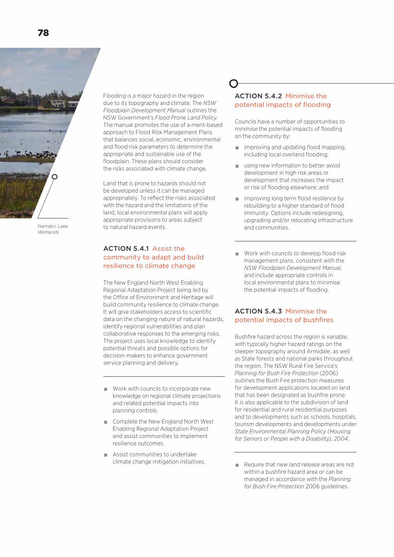
ACTION 5.4.2 Minimise the potential impacts of flooding
Councils have a number of opportunities to minimise the potential impacts of flooding on the community by:
• improving and updating flood mapping, including local overland flooding;
• using new information to better avoid development in high risk areas or development that increases the impact or risk of flooding elsewhere; and
• improving long term flood resilience by rebuilding to a higher standard of flood immunity. Options include redesigning, upgrading and/or relocating infrastructure and communities.
• Work with councils to develop flood risk management plans, consistent with the NSW Floodplain Development Manual, and include appropriate controls in local environmental plans to minimise the potential impacts of flooding.
ACTION 5.4.3 Minimise the potential impacts of bushfires
Bushfire hazard across the region is variable, with typically higher hazard ratings on the steeper topography around Armidale, as well as State forests and national parks throughout the region. The NSW Rural Fire Service’s Planning for Bush Fire Protection (2006) outlines the Bush Fire protection measures for development applications located on land that has been designated as bushfire prone. It is also applicable to the subdivision of land for residential and rural residential purposes and to developments such as schools, hospitals, tourism developments and developments under State Environmental Planning Policy (Housing for Seniors or People with a Disability), 2004.
• Require that new land release areas are not within a bushfire hazard area or can be managed in accordance with the Planning for Bush Fire Protection 2006 guidelines.
Flooding is a major hazard in the region due to its topography and climate. The NSW Floodplain Development Manual outlines the NSW Government’s Flood Prone Land Policy. The manual promotes the use of a merit-based approach to Flood Risk Management Plans that balances social, economic, environmental and flood risk parameters to determine the appropriate and sustainable use of the floodplain. These plans should consider the risks associated with climate change.
Land that is prone to hazards should not be developed unless it can be managed appropriately. To reflect the risks associated with the hazard and the limitations of the land, local environmental plans will apply appropriate provisions to areas subject to natural hazard events.
ACTION 5.4.1 Assist the community to adapt and build resilience to climate change
The New England North West Enabling Regional Adaptation Project being led by the Office of Environment and Heritage will build community resilience to climate change. It will give stakeholders access to scientific data on the changing nature of natural hazards, identify regional vulnerabilities and plan collaborative responses to the emerging risks. The project uses local knowledge to identify potential threats and possible options for decision-makers to enhance government service planning and delivery.
• Work with councils to incorporate new knowledge on regional climate projections and related potential impacts into planning controls.
• Complete the New England North West Enabling Regional Adaptation Project and assist communities to implement resilience outcomes.
• Assist communities to undertake climate change mitigation initiatives.
Narrabri Lake Wetlands
78

ACTION 5.4.4 Minimise the potential impacts of naturally occurring asbestos
Within the New England North West, the Great Serpentine Belt from Tamworth to Bingara is identified as one of the main areas in NSW for naturally occurring asbestos. This type of asbestos only poses a health risk when elevated levels of fibres are released into the air, either by human activities or by natural weathering, and these fibres are inhaled by humans.
Local Government NSW has developed a Model Asbestos Policy on behalf of the Heads of Asbestos Coordination Authorities. The policy has been developed to help councils formulate an asbestos policy and to promote a consistent approach to asbestos management.
• Require that councils affected by areas of naturally occurring asbestos use appropriate approaches to manage the risks of disturbance.
FIGURE 18: NATURAL DISASTER DECLARATIONS FROM 2004–05 TO 2013–14
Number of Natural Disaster Declarations
Storm/Flood Bushfire
0 1 2 3 4 5 6 7 8 9 10 12 14 16
Liverpool Plains
Moree Plains
Armidale Regional
Narrabri
Glen Innes Severn
Gwydir
Tenterfield
Gunnedah
Inverell
Tamworth Regional
Walcha
Uralla
Source: Ministry for Police and Emergency Services
79DRAFT NEW ENGLAND NORTH WEST REGIONAL PLAN

Endnotes
1 NSW Trade & Investment, (2015), New England North West Economic Profile, Prepared for the Economic Development Strategy for Regional NSW, Sydney
2 RMCG (2015) Agricultural Expansion Analysis: New England North West, Bendigo
3 NSW Department of Planning and Environment, (2016), NSW Population Projections 2011-36, Sydney
4 Op cit., New England North West Economic Profile
5 Op cit., Agricultural Expansion Analysis: New England North West
6 Ibid.
7 Australian Bureau of Statistics (2011), Census of Population and Housing, Canberra
8 Op cit., Agricultural Expansion Analysis: New England North West
9 Ibid.
10 Local Land Services, (2013), NSW Biosecurity Strategy 2013-2021, www.lls.nsw.gov.au/biosecurity/strategy-and-policy
11 Transport for NSW, (2015), Northern NSW Containerised Cargo Demand Assessment, Sydney
12 NSW Government, (2014), Rebuilding NSW, State Infrastructure Strategy, Sydney
13 Op cit., Agricultural Expansion Analysis: New England North West
14 Transport for NSW (2015), Newell Highway Corridor Strategy, Chippendale
15 RMCG (2015), Stakeholder consultation meetings report, Agricultural Expansion Analysis New England North West, Bendigo
16 NSW Department of Industry, (2015), Division of Resources and Energy Policy officer-level input into the New England North West Regional Plan
17 Ibid.
18 Council of Australian Governments, Standing Council on Energy and Resources (2013), Multiple Land Use Framework, Canberra
19 Department of Industry, Resources and Energy, (2013), Renewable Energy Action Plan, Sydney
20 TransGrid, (2015), Next steps for the Renewable Energy Hub, https://www. transgrid.com.au/news-views/blog/Lists/ Posts/Post.aspx?ID=47
21 Calculation based on Australian Bureau of Statistics, Estimated Resident Population by LGA (ASGS 2014), 2001 to 2014, Canberra
22 Op cit., NSW Population Projections 2011-36, Sydney
23 Op cit., NSW Household and Dwelling Projections 2011-36, Sydney
24 Ibid.
25 Op cit., Census of Population and Housing, Canberra
26 NSW Treasury, NSW Budget Papers 2010-11 – 2015-16, Sydney
27 NSW Department of Education and Communities, (2014), Analysis using Department of Planning and Environment, NSW Household and Dwelling Projections, 2014, Sydney
28 Op cit., NSW Population Projections 2011-36, Sydney
29 Op cit., Census of Population and Housing, Canberra
80

45 Joint Steering Committee for Water Sensitive Cities, (2009), Evaluating Options for Water Sensitive Urban Design (WSUD)
46 Department of Primary Industries, Office of Water, (2012), Controlled activities on waterfront land – Guidelines for riparian corridors on waterfront land, Sydney
47 NSW Department of Planning and Environment, (2015), Calculation based on Geographic Information System Analysis of Office of Environment and Heritage Data
48 Ibid.
49 NSW Office of Environment and Heritage, (2015), State Heritage Register and AHIMS Register, Sydney
50 NSW Office of Environment and Heritage, (2014), New England North West Climate Change Snapshot, Sydney
51 Analysis provided by the Ministry for Police and Emergency Services, 2015
30 Ibid.
31 National Institute of Economic and Industry Research, (2014), National economic indicators for local government areas, 2013/2014 http://economic-indicators.id.com.au/, Victoria
32 Op cit., Census of Population and Housing, Canberra
33 Op cit., NSW Population Projections 2011-36, Sydney
34 Ibid.
35 Ibid.
36 Ibid.
37 Op cit., Census of Population and Housing, Canberra
38 Op cit., National economic indicators for local government areas, 2013/2014 http://economic-indicators.id.com.au/
39 Armidale Dumaresq Council, (2015), New England Regional Airport Master Plan, http://create2350.com.au/wp-content/uploads/2015/06/NE-Regional-Airport-Master-Plan-FINAL.pdf
40 NSW Treasury, NSW Budget Papers 2010-11 to 2015-16 Budget Papers, Sydney
41 Transport for NSW, (2015), NSW Intrastate Regional Aviation Statistics, Patronage Summary September 1996 to June 2015, Sydney
42 Ibid.
43 Destination NSW, (2015), New England North West Visitor Statistics – Snapshot year ending June 2015, Sydney
44 NSW Trade & Investment, (2015), New England North West Economic Profile, Prepared for the Economic Development Strategy for Regional NSW, Sydney
81DRAFT NEW ENGLAND NORTH WEST REGIONAL PLAN

82 DRAFT NEW ENGLAND NORTH WEST REGIONAL PLAN
For more information about the Draft New England North West Regional Plan 2036 visit planning.nsw.gov.au