Neighborhood Park Maps, Plans and Drawings Collection FP ...
90
Fairmount Archives 10/1/2012 Neighborhood Park Maps, Plans and Drawings Collection FP.2012.002 Finding aid prepared by Caity Tingo This finding aid was produced using the Archivists' Toolkit October 01, 2012 Describing Archives: A Content Standard
-
Upload
truongtruc -
Category
Documents
-
view
218 -
download
1
Transcript of Neighborhood Park Maps, Plans and Drawings Collection FP ...
Fairmount Archives10/1/2012
Neighborhood Park Maps,Plans and Drawings Collection
FP.2012.002 Finding aid prepared by Caity Tingo
This finding aid was produced using the Archivists' Toolkit
October 01, 2012
Describing Archives: A Content Standard

Neighborhood Park Maps, Plans and Drawings Collection FP.2012.002
- Page 2 -
Table of Contents
Summary Information ................................................................................................................................. 3
Scope and Contents Note.............................................................................................................................. 4
Arrangement Note..........................................................................................................................................4
Administrative Information .........................................................................................................................4
Related Materials ........................................................................................................................................ 5
Controlled Access Headings..........................................................................................................................5
Collection Inventory...................................................................................................................................... 7
Awbury Park, Bainbridge Green, Bradford Park, Cloverly Park, Delaware Avenue, and Delaware
Avenue area parks................................................................................................................................... 7
Burholme Park....................................................................................................................................... 14
Eastwick Park and Elmwood Park........................................................................................................ 20
Eden Hall, Fluehr Park, Fox Chase Recreation Center, and Franklin Square...................................... 23
Fernhill Park, Fisher Park, Germany Hill, and Girard Park................................................................. 29
Harpers Hollow, Hunting Park, and Kemble Park................................................................................33
John F. Byrne Golf Course, Krewstown Stables, La Noce Park, Loudoun Park, Marconi Plaza..........44
Palmer Park, Pastorius Park, Penn Treaty Park, Poquessing Creek Park, and Pulaski Park................. 56
Rittenhouse Square and Roosevelt Boulevard...................................................................................... 66
Wakefield Park, Washington Square, Winston Park, Wister's Woods Park, Woodford Pines and the
Vine Street Expressway.........................................................................................................................80

Neighborhood Park Maps, Plans and Drawings Collection FP.2012.002
- Page 3 -
Summary Information
Repository Fairmount Archives
Title Neighborhood Park Maps, Plans and Drawings Collection
Date [bulk] Bulk, 1922-1983
Date [inclusive] 1860-2011
Extent 20.0 Linear feet
Language English
Abstract Included in this collection are maps, plans, and drawings of some of the
locations operated by the Philadelphia Parks and Recreation Department.
It primarily contains documentation on smaller neighborhood parks and
squares. In addition to operating these locations, the Philadelphia Parks
and Recreation Department also cares for street trees throughout the city,
and a small number of records related to prominent streets (particularly
Roosevelt Boulevard) are also included in this collection.
Preferred Citation note
[Description and date of item], FP.2012.002, Neighborhood Park Maps, Plans and Drawings Collection,Fairmount Park Historic Resource Archives.

Neighborhood Park Maps, Plans and Drawings Collection FP.2012.002
- Page 4 -
Scope and Contents Note
Of the 70+ parks within the Fairmount Park system, there is a disparate amount of material available inthis collection. Major watershed parks (such as Fairmount Park and Wissahickon Park) are not coveredin this collection, nor are significant indepedent parks such as FDR Park and Bartram's Garden. Thiscollection is concentrated on neighborhood parks, particularly smaller parks and squares.
Some parks are undocumented, or have only one or two related items, while other parks have a wealthof material available. The collection is particularly strong in material related to Awbury Park. BurholmePark, Fernhill Park, Franklin Square, Eastwick Park, Hunting Park, Pastorius Park, Penn Treaty Park, andWashington Square. Specific areas of note include Awbury Arboretum, the Burholme Mansion, LoganHouse, and the Rittenhouse Square Guard House. Also included are documents relating to RooseveltBoulevard and the Vine Street Expressway, as they are under the jurisdication of the Fairmount ParkCommission.
Within the collection are variety of materials, roughly 99% of which are maps, drawings, or plans. Thereis a very limited number of correspondence directly relating to materials which have been arrangedaccordingly to preserve their relationship. The documents are largely printed on paper, mylar or linen, andrange from pencil sketches to blueprints and bluelines. Size varies from legal-sized documents to large,oversized items.
Arrangement Note
This collection has been arranged into ten series, which divide the collection alphabetically by park orgroup of parks within the Fairmount Park system. These series have been further subdivided into files,continuing the alphabetical order. Parks which are particularly well-documented have their own folder orfolders within a series, which may slightly affect alphabetical groupings. Additionally, certain parks arecommonly paired with nearby park neighbors. In these cases- Delaware Avenue area parks, Fluehr Parkand Eden Hall, Harpers Hollow and Kemble Park, and Wakefield Park and Wister Woods- priority hasbeen given to their relationships over alphabetical order.
Administrative Information
Publication Information

Neighborhood Park Maps, Plans and Drawings Collection FP.2012.002
- Page 5 -
Fairmount Archives 10/1/2012
Conditions Governing Access note
This collection is open for research.
Conditions Governing Use note
Copyright restrictions may apply. Please contact the Archives with requests for copying and forauthorization to publish, quote or reproduce the material.
Related Materials
Related Archival Materials note
Please see the Basement Recovery Collection for additional plans of neighborhood parks (limited).
Controlled Access Headings
Geographic Name(s)
• Awbury Arboretum (Philadelphia, Pa.)• Awbury Park (Philadelphia, Pa.)• Bainbridge Green (Philadelphia, Pa.)• Bradford Park (Philadelphia, Pa.)• Burholme Mansion• Burholme Park (Philadelphia, Pa.)• Cloverly Park (Philadelphia, Pa.)• Delaware Avenue• Eden Hall (Philadelphia, Pa.)• Fernhill Park (Philadelphia, Pa.)• Fisher Park• Fluehr Park (Philadelphia, Pa.)• Foglietta Plaza• Fox Chase Recreation Center (Philadelphia, Pa.)

Neighborhood Park Maps, Plans and Drawings Collection FP.2012.002
- Page 6 -
• Franklin Square (Philadelphia, Pa.)• Germany Hill (Philadelphia, Pa.)• Girard Park (Philadelphia, Pa.)• Harpers Hollow• Hunting Park (Philadelphia, Pa.)• I-95 Park (Philadelphia, Pa.)• John F. Byrne Golf Course• Kemble Park• Krewstown Stables (Philadelphia, Pa.)• La Noce Park (Philadelphia, Pa.)• League Island Park• Logan House (Philadelphia, Pa.)• Loudon Mansion (Philadelphia, Pa.0• Loudoun Park (Philadelphia, Pa.)• Marconi Plaza (Philadelphia, Pa.)• Palmer Park (Philadelphia, Pa.)• Pastorius Park (Philadelphia, Pa.)• Penn Treaty Park (Philadelphia, Pa.)• Penn's Landing• Poquessing Creek Park (Philadelphia, Pa.)• Pulaski Park• Rittenhouse Square Guard House• Roosevelt Boulevard (Philadelphia, Pa.)• Vine Street Expressway• Wakefield Park (Philadelphia, Pa.)• Winston Park• Wister's Woods Park (Philadelphia, Pa.)• Woodford Pines
Subject(s)
• Rittenhouse Square (Philadelphia, Pa.)--Maps, Pictorial.• Washington Square (Philadelphia, Pa.)--Buildings, structures, etc.--Pictorial works.
Neighborhood Park Maps, Plans and Drawings Collection FP.2012.002
Awbury Park, Bainbridge Green, Bradford Park, Cloverly Park, Delaware Aven...
- Page 7 -
Collection Inventory
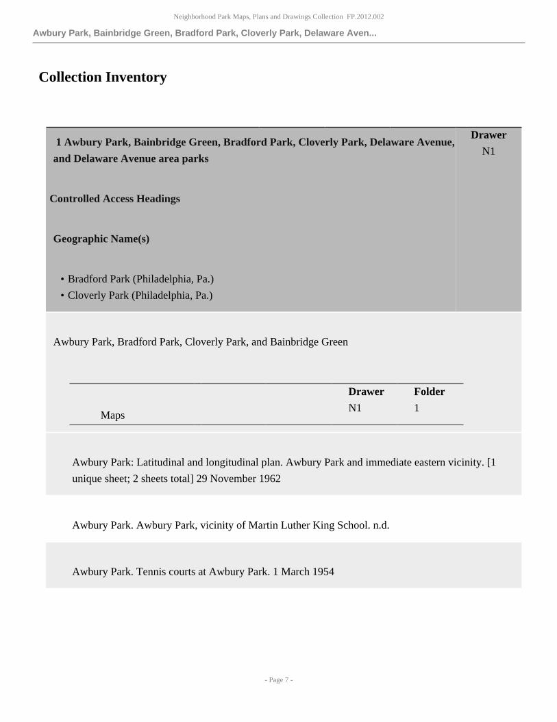
1 Awbury Park, Bainbridge Green, Bradford Park, Cloverly Park, Delaware Avenue,
and Delaware Avenue area parks
Controlled Access Headings
Geographic Name(s)
• Bradford Park (Philadelphia, Pa.)
• Cloverly Park (Philadelphia, Pa.)
Drawer
N1
Awbury Park, Bradford Park, Cloverly Park, and Bainbridge Green
Drawer Folder
Maps N1 1
Awbury Park: Latitudinal and longitudinal plan. Awbury Park and immediate eastern vicinity. [1
unique sheet; 2 sheets total] 29 November 1962
Awbury Park. Awbury Park, vicinity of Martin Luther King School. n.d.
Awbury Park. Tennis courts at Awbury Park. 1 March 1954

Neighborhood Park Maps, Plans and Drawings Collection FP.2012.002
Awbury Park, Bainbridge Green, Bradford Park, Cloverly Park, Delaware Aven...
- Page 8 -
Awbury Park. Topographic plan of Awbury Park, labeled "incorrect". 8 August 1960
Awbury Park. Awbury Park School, construction encroachment. n.d.
Awbury Park: Awbury Arboretum. Plan made for the use of the Board of View in the matter of the
condemnation of a tract of land placed on the city plan as a public park under the name of Awbury
Arboretum bounded by Haines Street, Ardleigh Street, Tulpehocken Street, Stenton Avenue, the
property line in th bed of the present Walnut Lane and the property line extending southeastward
therefrom to Haines Street. [fragile] 27 February 1933
Awbury Park: Awbury Arboretum. Plan showing properties in the vicinity of Awbury Arboretum,
area bounded by Haines Street, Chew Street, Reading Railroad, Johnson Street, Ardleigh Street,
Washington Lane and Stenton Avenue, 190 acres more or less. 4 March 1932
Awbury Park: Awbury Arboretum. Plan to revise the lines and grades of a portion of city plan no.
177 and to place thereon a public park under the name of Awbury Arboretum. [1 unique sheet; 2
sheets total] 18 January 1926
Controlled Access Headings
Geographic Name(s)
• Awbury Arboretum (Philadelphia, Pa.)
Bainbridge Green. Irrigation system for Bainbridge Green: Site plan, section, P1. [1 unique sheet; 4
sheets total]

Neighborhood Park Maps, Plans and Drawings Collection FP.2012.002
Awbury Park, Bainbridge Green, Bradford Park, Cloverly Park, Delaware Aven...
- Page 9 -
Bradford Park. Topographic plan of Bradford Park. 13 March 1983
Cloverly Park. Plan of existing conditions for proposed sidewalk and curb. 15 May 1970
Cloverly Park. Landscape plan with notes on pathway conditions. [fragile] 8 December 1954
Cloverly Park. Plan of Cloverly Park. 6 May 1937
Cloverly Park. Latitudinal and longitudinal plan of Cloverly Park with topographic details. 2 April
1982
Cloverly Park. Plan of Cloverly Park with landscape, pathway, and shelter details. 24 May 1961
Cloverly Park. Plan of pavilion. n.d.
Delaware Avenue and Delaware Avenue area parks: Foglietta Plaza, I-95 Park, and Penns Landing
Drawer Folder
Maps N1 2
Delaware Avenue. Delaware Expressway Cover: Special 12 inch square by 20 inch high Kube-Lite
on 4 inch square straight aluminum poles; special 12 inch square by twenty inch high Kube-Lite
detail. [2 unique sheets; 2 sheets total] October 1977

Neighborhood Park Maps, Plans and Drawings Collection FP.2012.002
Awbury Park, Bainbridge Green, Bradford Park, Cloverly Park, Delaware Aven...
- Page 10 -
Delaware Avenue. Pennsylvania Department of Transportation L.R. 1000 B-63: Base plate "C" 30
inches by 30 inches for support tube S-1; base plate "B" 30 inches by 30 inches for support tube
S-2; base plate "A' 30 inches by 30 inches for support tube S-3. [3 unique sheets; 3 sheets total] 6
October 1968
Delaware Avenue. Philadelphia Water Department, contract no. 68, Lardner's Point Pumping Station
no. 3: General plan of buildings (2); elevations of boiler house (11). [2 unique sheets; 2 sheets total]
[reproduction] 29 January 1904
Delaware Avenue. Philadelphia Water Department, Lardner's Point Pumping Station fire pipe line.
[reproduction] 20 October 1904
Delaware Avenue. Philadelphia Water Department, Lardner's Point Pumping Station no. 3 extension
of fire services and boiler feed lines. [reproduction] 10 June 1908
Delaware Avenue. Philadelphia Water Department, contract no. 141, discharge pipe connections
Lardner's Point Pumping Station no. 3, plan and profile. 19 February 1908
Delaware Avenue. Philadelphia Water Department, contract no. 29, Lardner's Point Pumping Station
no. 3: Conduits and piping (3); general plan of buildings (2). [2 unique sheets; 2 sheets total] June
1902
Foglietta Plaza: The Korean War Memorial. The Korean War Memorial, Foglietta Plaza, Front
Street and Spruce Street: Cover sheet, CS-1; existing conditions plan, CE-1; demolition plan, CE-2;
site plan, CE-3; details, CE-4; plans and elevations, A2.01; elevations and details, A2.02; plans and
details, S2.01. [8 unique sheets; 8 sheets total] 1 September 2000

Neighborhood Park Maps, Plans and Drawings Collection FP.2012.002
Awbury Park, Bainbridge Green, Bradford Park, Cloverly Park, Delaware Aven...
- Page 11 -
I-95 Park. Topographic plan for I-95 Park: Front Street at Chestnut Street, sheet 1 of 3; Front Street
from Pine Street to Dock Street, sheet 2 of 3; Front Street from Kenilworth Street to Fitzwater
Street, sheet 3 of 3. [3 unique sheets; 3 sheets total] 13 March 1983
I-95 Park. Earthwork summary, entire project: Index, location map, public utilities chart; site plan A
at the western intersection of Spruce Street and Delaware Avenue; site plan B at the intersection of
Spruce Street and Mattis Street; site plan C at the eastern intersection of Spruce Street and Delaware
Avenue; site plan D at the intersection of Delaware Avenue and Chestnut Street. [4 unique sheets; 4
sheets total] n.d.
Drawer Folder
Maps N1 2
Woodacre, G.G. I-95 Park: The Irish Memorial. Sketch drawing of The Irish Memorial,
Philadelphia, Pennsylvania. 1998
I-95 Park. Philadelphia I-95: Plan of fountain and pump room, section of sump and grate; pumproom
equipment, pumproom north wall elevation, and base of fountain feature. [2 unique sheets; 2 sheets
total] 4 January 1978
I-95 Park. Bench plans for I-95 Park: Plan condition "A" and typical section with equipment notes;
type 1 wood benches, type 2 wood benches, and type 3 benches. 27 March 1978
I-95 Park. I-95 Philadelphia: Pool and equipment details, sheet 1 of 4; pumproom details, sheet 2 of
4; fountain feature assembly details, sheet 3 of 4; fountain feature assembly details, sheet 4 of 4. [4
unique sheets; 4 sheets total 9 February 1978

Neighborhood Park Maps, Plans and Drawings Collection FP.2012.002
Awbury Park, Bainbridge Green, Bradford Park, Cloverly Park, Delaware Aven...
- Page 12 -
I-95 Park. Fountain plans: Fountain feature tube measurements, plan for sculpture and piping
schematic, typical section tubes and spacers, spacer length and placement, drawing 1 of 2; fountain
feature sections, riser diagrams, and details, drawing 2 of 2; pump room and fountain plan piping
schematic, sections, and details, sheet 1 of 2; pump room equipment and sections, sheet 2 of 2. [4
unique sheets; 8 sheets total] [bound] 6 October 1978
I-95 Park. Fountain feature: Custom play unit (type 1) with hardware descriptions, sheet 1 of 6;
custom play unit (type 2) plan and line elevations, sheet 2 of 6; custom play unit (type 2) line
elevations, sheet 3 of 6; custom play unit (type 2) line elevations and deck construction details, sheet
4 of 6; custom play unit (type 40 plan and elevations, sheet 5 of 6; assembly information, sheet 6 of
6. [6 unique sheets; 12 sheets total] 12 October 1978
I-95 Park. I-95 restroom: Hardware information and elevations, sheet 1 of 2; plan with sections and
details, sheet 2 of 2. [2 unique sheets; 2 sheets total] 30 June 1978
I-95 Park. Pennsylvania Department of Transportation restrooms, foot of Spruce Street,
Philadelphia, Pennsylvania, elevations, chart of door types and frames, and general notes. 21 July
1978
I-95 Park. Ceiling grid details, restrooms and pumproom, Spruce Street. 31 October 1978
I-95 Park. Water supply and irrigation, tabulation of water supply and irrigation quantities,
sheet 1 of 6; water supply and irrigation details, sheet 2 of 6; water supply and irrigation plan A,
sheet 3 of 6; water supply and irrigation plan B, sheet 4 of 6; water supply and irrigation plan
C, sheet 5 of 6; water supply and irrigation plan D, sheet 6 of 6. [6 unique sheets, 4 copy sheets;
10 sheets] n.d. Generally, sheets 1 through 6 of these drawings are available in two formats- a
larger 22" x 36" version, and a smaller 12" X 18" format. The smaller copies are heavily marked in
comparison with the larger drawings.

Neighborhood Park Maps, Plans and Drawings Collection FP.2012.002
Awbury Park, Bainbridge Green, Bradford Park, Cloverly Park, Delaware Aven...
- Page 13 -
Other Finding Aids note
Drawings sheet 1, sheet 2, sheet 3, sheet 4, and sheet 5 are available in the larger format, while
drawings sheet 1, sheet 2, sheet 4, sheet 5, and sheet 6 are available in the smaller format.
Controlled Access Headings
Geographic Name(s)
• I-95 Park (Philadelphia, Pa.)
I-95 Park. Pedestrian lighting system, tabulation of pedestrian lighting system quantities, sheet 1 of
7; pedestrian lighing system details plan 1, sheet 2 of 7; pedestrian lighting system details plan 2,
sheet 3 of 7; pedestrian lighting system plan A, sheet 4 of 7; pedestrian lighting system plan B, sheet
5 of 7; pedestrian lighting system plan C, sheet 6 of 7; pedestrian lighting system plan D, sheet 7 of
7. [7 unique sheets; 7 sheets total] n.d. All sheets are heavily marked from use.
Controlled Access Headings
Geographic Name(s)
• I-95 Park (Philadelphia, Pa.)
I-95 Park. Electrical distribution system: Construction sketch B 63-8; construction sketch B 63-9;
electrical distribution system sheet 1 of 2; electrical distribution system sheet 2 of 2. [4 sheets] 12
September 1978
Penn's Landing: The Philadelphia Vietnam Veterans Memorial. The Philadelphia Vietnam Veterans
Memorial: Cover sheet; site plan, A1; sections, elevations, and planter corner detail, A2; brick

Neighborhood Park Maps, Plans and Drawings Collection FP.2012.002
Burholme Park
- Page 14 -
details, detail elevations, and wall sections, A3; wall sections with flagpole and light, A4; site plan,
A5; landscape specifications and plan, A6; foundation plan, S1; wall details and sections and general
structural notes, S2; power plan and control box detail, E1; lighting fixture schedule and details, E2;
site drainage plan, P1. [1 copy] [12 unique sheets; 13 sheets total] 12 June 1987
Penn's Landing: The Philadelphia Vietnam Veterans Memorial. Irrigation plan. 1 August 1987
Penn's Landing: The Philadelphia Vietnam Veterans Memorial. Site plan "A", with legend site
plans. n.d.
2 Burholme Park Drawer
N2
Burholme Park
Drawer Folder
Maps N2 1
Burholme Park. Sewer through Burholme Park from Cottman Avenue to a point at Shelmire Avenue
and Fillmore Street and in Fillmore Street from Shelmire Avenue to Napfle Avenue. [1 unique sheet;
2 sheets total] 14 June 1943
Burholme Park. Plan showing property line made for Fairmount Park Commission. 24 June 1974
Burholme Park. Grade plan of streets in Burholme Terrace, Abington Township, Montgomery
County, Pennsylvania, made for Charles C. Klein, bounded by Church Toad, Sylvandale Avenue,
Fillmore Street, and Cottman Avenue. 7 May 1925
Neighborhood Park Maps, Plans and Drawings Collection FP.2012.002
Burholme Park
- Page 15 -
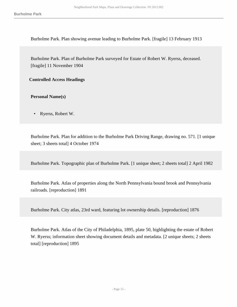
Burholme Park. Plan showing avenue leading to Burholme Park. [fragile] 13 February 1913
Burholme Park. Plan of Burholme Park surveyed for Estate of Robert W. Ryerss, deceased.
[fragile] 11 November 1904
Controlled Access Headings
Personal Name(s)
• Ryerss, Robert W.
Burholme Park. Plan for addition to the Burholme Park Driving Range, drawing no. 571. [1 unique
sheet; 3 sheets total] 4 October 1974
Burholme Park. Topographic plan of Burholme Park. [1 unique sheet; 2 sheets total] 2 April 1982
Burholme Park. Atlas of properties along the North Pennsylvania bound brook and Pennsylvania
railroads. [reproduction] 1891
Burholme Park. City atlas, 23rd ward, featuring lot ownership details. [reproduction] 1876
Burholme Park. Atlas of the City of Philadelphia, 1895, plate 50, highlighting the estate of Robert
W. Ryerss; information sheet showing document details and metadata. [2 unique sheets; 2 sheets
total] [reproduction] 1895

Neighborhood Park Maps, Plans and Drawings Collection FP.2012.002
Burholme Park
- Page 16 -
Burholme Park. 1860, section 25, area of Livezeytown. [reproduction] [1 unique sheet; 2 sheets
total] 1860
Burholme Park. Atlas of the City of Philadelphia, 35th Ward, plate 14. [reproduction] 1927
Burholme Park. Atlas of the 23rd, 33rd, and 41st wards of the City of Philadelphia, plate 22.
[reproduction] 1910
Burholme Park. Atlas of the City of Philadelphia, 35th ward, plate 14. [reproduction] 1921
Burholme Park. Plan for striking from city plan no. 346 and the vacation of Shelmire Avenue from
a point approximately ninety-six feet southeast of Burholme Avenue (fifty feet wide) extended,
to Central Avenue the striking from the city plan of Burholme Avenue from Shelmire Avenue
to Cottman Avenue and of Orville Avenue from Burholme Avenue to Cottman Avenue and the
revision of lines and grades of intersecting and adjacent streets affected thereby. [1 unique sheet; 2
sheets total] [fragile] 1 August 1955
Burholme Park. Study of proposed road and parking area. 17 May 1963
Burholme Park. Site plan and building improvements at Burholme Park: Baseball fields and toilet
building, A1 [2 copies]; landscaping plan, schedule, details, A2 [1 copy]; plan and estimate for
resurfacing roads and paving parking lots, character of work descriptions, A3 [1 copy]; plan and
estimate for resurfacing roads and paving parking lots, A4 [1 copy]. [4 unique sheets; 9 sheets
total] November 1984
Burholme Park. Plot plan, Burholme Park, with platform detail. [1 unique sheet; 2 sheets total] n.d.

Neighborhood Park Maps, Plans and Drawings Collection FP.2012.002
Burholme Park
- Page 17 -
Burholme Park. Plan of Burholme Park; topographic overlay. [2 unique sheets; 2 sheets total] 1966
Burholme Park. Plan and estimate for paving Central Avenue from Cottman Avenue to Hasbrook
Avenue: Cottman Avenue to Line "A", sheet no. 1 of 3 sheets; Line "A" to Line "B", sheet no. 2 of 3
sheets. [2 unique sheets; 2 sheets total] n.d.
Burholme Park: Sewer plan. Plan no. 83, Torresdale High Service, vicinity of Burholme Park. [1
unique sheet; 3 sheets total] October 1959
Burholme Park. Plan and estimate for paving and grading roadway in Burholme Park from Cottman
Avenue west of Central Avenue to north of Cottman Avenue: Burholme Park existing roads, sheet
1 of 2; Burholme Driving Range grading sections and location plan, sheet 2 of 2 [1 copy]. [2 unique
sheets; 2 sheets total] June 1966
Burholme Park. Zoning plan, Fox Chase Cancer Center, 100 Laurel Lane, proposed Hope Lodge
Villa. 28 July 2003
Burholme Park. Northeast Optimist Club, Northeast Optimist Support Facility: Cover sheet, site
plan and details, CS; site survey, topographic plan, C1; plans, elevations and details, A1.0; building
wall section and details, A2.0; schedules and details, A3.0; details, A4.0; structural drawing, S1;
mechanical floor plan, M1; plumbing floor plan, P1; electrical site plan and electrical floor plan, E1.
[10 unique sheets; 2 sheets total] 29 June 1998
Burholme Park. Plan showing location of buildings in Burholme Park. [fragile] 22 December 1920

Neighborhood Park Maps, Plans and Drawings Collection FP.2012.002
Burholme Park
- Page 18 -
Burholme Park. Plan and estimate for paving and grading new road in Burholme Park 20 feet wide
from Cottman Avenue 1400 feet west of Central Avenue to 850 feet north of Cottman Avenue. 6
April 1964
Burholme Park. Construction of Burholme Park lighting Cottman Avenue and Central Avenue, bid
no. 5813: Electrical site plan, E1, sheet 1 of 2; details, E2, sheet 2 of 2. [2 unique sheets; 2 sheets
total] n.d.
Burholme Park. Proposed road and repaving. 7 March 1965
Burholme Park. Burholme Park new tot lot, Cottman and Central avenues. 31 March 1970
Burholme Park. Plan of Burholme Driving Range with grade elevations. 29 October 1956
Burholme Park. Cross sections east and south of Cottman Avenue. [1 unique sheet; 2 sheets total] 29
June 1966
Burholme Park. Burholme Park Golf Driving Range, notes on pavement conditions and
revisions. April 1977
Burholme Park. Plan of Cottman Avenue and Central Avenue, 23 locations of new paving, notes on
grass and concrete. 7 May 1982
Burholme Park. Burholme Park encroachment. n.d.

Neighborhood Park Maps, Plans and Drawings Collection FP.2012.002
Burholme Park
- Page 19 -
Burholme Park. Plan and profile, Fillmore Street between Mayfield Avenue and Shelmire
Street. February 1966
Burholme Park: Landscape plan. Preliminary entrance road - Burholme Park - Fox Chase Cancer
Center. [reproduction] 5 October 1988
Burholme Park: Burholme Mansion and Carriage House
Drawer Folder
Maps N2 2
Burholme Park: Burholme Mansion. Inventory of blueprints in 3rd floor Rare Books Room of
Burholme Mansion: page 1 of 3; page 2 of 3; page 3 of 3. [3 unique sheets; 3 sheets total] 7
November 2003
Burholme Park: Burholme Mansion and Carriage House. Alterations to Mansion, Burholme Park:
First floor plan, drawing no. 1; second floor plan, drawing no. 2; third floor plan, details, etc.,
columns, bookcases, etc.; basement plan, drawing no. 4. [3 unique sheets; 3 sheets total] [fragile] 1
March 1907 These items are in extremely fragile condition. The material is brittle, portions are
missing and torn away, and many have nearly torn in half. Handle with care.
Burholme Park: Burholme Mansion and Carriage House. Alterations and additions to Mansion,
Burholme Park: First floor plan, second floor plan, basement plan, and roof plan, drawing no.
1 [1 copy]; elevations and section plan, drawing no. 2; plot plan, exterior plans, plan of toilets;
second floor cornice plan, drawing no. 3 [2 copies]. [3 unique sheets; 6 sheets total] [fragile] June

Neighborhood Park Maps, Plans and Drawings Collection FP.2012.002
Eastwick Park and Elmwood Park
- Page 20 -
1921 These items are in extremely fragile condition. The material is brittle, portions are missing
and torn away, and many have nearly torn in half. Handle with care.
Burholme Park: Burholme Mansion and Carriage House. Alterations and additions to Mansion,
Burholme Park: First floor plan; second floor plan; basement plan; northeast elevation; northwest
elevation; new and existing section. [6 unique sheets; 6 sheets total] [fragile] 17 January 1921
Burholme Park: Burholme Mansion and Carriage House. Restoration of the Burholme Mansion and
Carriage House: Cover; basement and first floor plans and details, A2; second and third floor plans
and details, A3; attic and tower plans and details, A4; elevations and sections, A5; sections/stair
sections and details, A6; stair plans, sections and details, A7; Carriage House plans and elevations
and details, A8; site plan and details, AHP E1; structural basement and first floor plans, sectionss
and details, S1; structural second floor plans sections, and details, S2; HVAC- basement and first
floor plans, schedules, and details, H2; HVAC- second and third floor plans and attic details, H3;
basement and first floor plan (plumbing) sanitary riser diagram, P2; second and third floor plan
(plumbing), basement floor plan, sprinkler, and halon, P3; basement and first floor plan and details
(electrical), E2 [1 copy]; second floor and third floor plan and details (electrical), E3 [1 copy]; attic
and tower plan and details (electrical), E4 [1 copy]. [18 unique sheets; 21 sheets total] 1 February
1978
Burholme Park: Burholme Mansion and Carriage House. Painting and woodwork repair at Burholme
Mansion, elevations. September 1985
Burholme Park: Burholme Mansion and Carriage House. Exterior renovations to: Burholme
Mansion and Carriage House: Title sheet, location map, symbols, index, G-001; first floor veranda
plan, A-101; Mansion south elevation, A-201; Mansion north elevation, A-202; Mansion east
elevation, A-203; Mansion west elevation, A-204; Mansion partial elevations, A-205; Carriage
House elevations, A-206. [9 unique sheets; 9 sheets total] 2 November 2001
5 Eastwick Park and Elmwood Park Drawer
N3

Neighborhood Park Maps, Plans and Drawings Collection FP.2012.002
Eastwick Park and Elmwood Park
- Page 21 -
Elmwood Park and Eastwick Park
Drawer Folder
Maps N3 1
Elmwood Park: The Labor Monument. The Labor Monument, Philadelphia's tribute to the American
worker: Cover sheet; existing conditions plan, G-1; erosion and sedimentation control plan, ES-1;
erosion and sedimenation control details, ES-2; site preparation and demolition plan, L-1; grading
plan, L-2; materials and planting plan, L-3; layout plan, L-4; details, path and pavement sections,
L-5; details, bench and planting sections and plans, footing details, L-6. [10 unique sheets; 20 sheets
total] 15 April 2011
Eastwick Park: Urban renewal. Eastwick urban renewal boundary and land use map. October 1969
Eastwick Park: Urban renewal. Eastwick urban renewal lande use map. [reproduction] May 1990
Eastwick Park: Urban renewal. Eastwick urban renewal land use plan, with detail on redevelopment
stages. n.d.
Eastwick Park: Plat plan. No. 42-S-22, depicting the area of Darby Creek at the Delaware County
line from 87th Street to 85th Street. September 1970
Eastwick Park: Plat plan. No. 44-S-12, approximately bounded by Darby Creek, 87th Street,
Grovers Avenue and 90th Street. 8 February 1973

Neighborhood Park Maps, Plans and Drawings Collection FP.2012.002
Eastwick Park and Elmwood Park
- Page 22 -
Eastwick Park: Plat plan. No. 26S23, approximately bounded by Cobbs Creek, 75th Street, Elmood
Avenue, and 77th Street. 29 December 1976
Eastwick Park: Plat plan. No. 37-S-13, approximately bounded by Cobbs Creek, 77th Street,
Chelwynde Avenue, and 79th Street. December 1969
Eastwick Park: Plat plan. No. 37-S-20, approximately bounded by Darby Creek, 83rd Street, Guyer
Avenue, and 85th Street. 26 March 1970
Eastwick Park: Plat plan. No. 50-S-7, approximately bounded by Cobbs Creek, 78th Street, Mars
Place, 80th Street, and Alpha Avenue. 27 January 1970
Eastwick Park: Plat plan. No. 30S21, approximately bounded by Island Avenue, Grays Avenue, 75th
Street, and Cobbs Creek. 11 May 1979
Eastwick Park: Plat plan. No. 35S4A, approximately bounded by Lloyd Street, Paschall Avenue,
Island Avenue, and Woodland Avenue. 11 May 1979
Eastwick Park. Eastwick Regional Park phases II and III: Grading and drainage plan. 12 May 1978
Eastwick Park. Eastwick Regional Park BERM phase: Site/grading plan. 6 January 1986
Eastwick Park. Eastwick Regional Park: Grading and drainage plan. 16 July 1976
Neighborhood Park Maps, Plans and Drawings Collection FP.2012.002
Eden Hall, Fluehr Park, Fox Chase Recreation Center, and Franklin Square
- Page 23 -
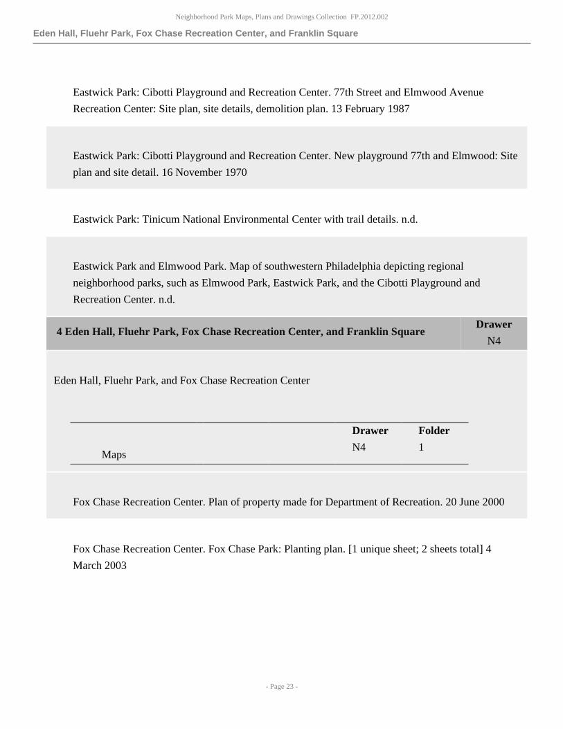
Eastwick Park: Cibotti Playground and Recreation Center. 77th Street and Elmwood Avenue
Recreation Center: Site plan, site details, demolition plan. 13 February 1987
Eastwick Park: Cibotti Playground and Recreation Center. New playground 77th and Elmwood: Site
plan and site detail. 16 November 1970
Eastwick Park: Tinicum National Environmental Center with trail details. n.d.
Eastwick Park and Elmwood Park. Map of southwestern Philadelphia depicting regional
neighborhood parks, such as Elmwood Park, Eastwick Park, and the Cibotti Playground and
Recreation Center. n.d.
4 Eden Hall, Fluehr Park, Fox Chase Recreation Center, and Franklin Square Drawer
N4
Eden Hall, Fluehr Park, and Fox Chase Recreation Center
Drawer Folder
Maps N4 1
Fox Chase Recreation Center. Plan of property made for Department of Recreation. 20 June 2000
Fox Chase Recreation Center. Fox Chase Park: Planting plan. [1 unique sheet; 2 sheets total] 4
March 2003

Neighborhood Park Maps, Plans and Drawings Collection FP.2012.002
Eden Hall, Fluehr Park, Fox Chase Recreation Center, and Franklin Square
- Page 24 -
Fox Chase Recreation Center. Fox Chase Recreation Center landscape improvement project. May
2003
Fleuhr Park. Topographic plan of Fluehr Park. [1 unique sheet; 3 sheets total] 18 April 1982
Fluehr Park. Fleuhr Park site improvements: Add alternate key plan, L-1. 1 February 2000
Fluehr Park. Plot plan made for Ramex International, Incorporated. 4 April 1986
Fluehr Park. Preliminary and final plat: Correspondence from Barbara J. Kaplan, Executive Director
of the Philadelphia City Planning Commission, to Stephen G. Pollock, Esquire; preliminary
and final plan made for Ramex International, Incorporated. [2 unique sheets; 2 sheets total] 14
November 1986
Fluehr Park. Plan showing immediate vicinity of Fluehr Park, approximately bounded by Convent
Lane, Torresdale Avenue, Grant Avenue, and the Pennsylvania Railroad. [fragile] n.d.
Fluehr Park. Plan of storm conduit on Longfield Street from Fitler Street to Grant Avenue. n.d.
Fluehr Park. Plan of Convent Lane, Torresdale Avenue to Tulip Street, depicts intersection of
Convent Lane and Hegerman Street. [in 3 pieces] [1 unique sheet; 2 sheets total] n.d.
Fluehr Park. Plan of Hegerman Street from N.H.L. Convent Avenue to N.H.L. Eden Street.
[reproduction] 28 September 1939
Neighborhood Park Maps, Plans and Drawings Collection FP.2012.002
Eden Hall, Fluehr Park, Fox Chase Recreation Center, and Franklin Square
- Page 25 -
Fluehr Park: Sewer plan. Plan of Longfield Street from Eden Street to Grant Avenue with notes on
sewer piping. [reproduction] n.d.
Fluehr Park: Sewer plan. Convent Lane: Hegerman Street to Tulip Street, sheet 3 of 4 [1 copy];
Torresdale Avenue to Hegerman Street, sheet 4 of 4 [in 2 pieces]. [2 unique sheets; 3 sheets total] 15
December 1972 Sheet 4 of 4, Torresdale Avenue to Hegerman Street, was initially taped together
to create one plan. The tape has since become brittle and the plan is now in two pieces. It is still in
fair condition.
Fluehr Park. Sanitary and storm drainage for 4725 Convent Lane, Fluehr Park. 19 March 1987
Fluehr Park. Plan of property made for public property, bounded by Torresdale Avenue, Grant
Avenue, Tulip Street, and Convent Lane with Eden Hall details. [1 unique sheet; 2 sheets total] 26
February 1975
Fleuhr Park: Sewer and water plan. Sewer and water plan: 8 inch diameter D.I. pipe water main and
10 inch diameter V.C. pipe sewer with 18 inch diameter R.C. pipe S.W. conduit in Torresdale Place
(private road) from Convent Lane at Torresdale Avenue to Convent Lane 200 feet, more or less,
southeast and 6 inch diameter D.I. pipe water main in 15 feet wide easement and Fluehr Park from
Torresdale Place to a point in Fluehr Park; plan of satellite maintenance building at Eden Hall dated
27 April 1987; plan of satellite maintenance building at Eden Hall dated 26 May 1987. [3 unique
sheets; 3 sheets total] 1987
Fluehr Park: Latitudinal and longitudinal plan. Plan of Fluehr Park, bounded by Torresdale Avenue,
Grant Avenue, Tulip Street and Convent Lane, with Eden Hall details. n.d.
Eden Hall. Topographic plan of Eden Hall. 18 April 1982

Neighborhood Park Maps, Plans and Drawings Collection FP.2012.002
Eden Hall, Fluehr Park, Fox Chase Recreation Center, and Franklin Square
- Page 26 -
Eden Hall. Fairmount Park satellite maintenance building, door and frame chart, elevations, sections,
and notes. 8 October 1985
Eden Hall. Satellite maintenance building: Cast iron wall grilles and frames, drawing no. 2; cast iron
wheel guards and fixed lintel, drawing no. 3; erection plan - roof steel, drawing no. 4; steel details,
drawing no. 5 [1 copy]. [4 unique sheets; 5 sheets total] 5 November 1986
Eden Hall. Pl. lam. top details. 5 January 1978
Franklin Square
Drawer Folder
Maps N4 2
Franklin Square. Franklin Square Renovations: Planting plan and planting key. [fragile] May 1935
Franklin Square. Franklin Square Station entrances and ventilators, 7th Street Extension. [fragile] 22
November 1933
Franklin Square. Plan of Franklin Square, bounded by Vine Street, Sixth Street, Race Street, and
Franklin Street. 11 September 1895
Franklin Square: Electrical Plan. Philadelphia Electric Company, plan of Franklin Square. 9
November 1935

Neighborhood Park Maps, Plans and Drawings Collection FP.2012.002
Eden Hall, Fluehr Park, Fox Chase Recreation Center, and Franklin Square
- Page 27 -
Franklin Square. Improvements to Franklin Square fountain lighting plan, fountain plumbing plan,
electrical notes, new pump vault plan, riser diagram, schematic elevations for pool equipment, and
schematic control diagram. [reproduction] [1 unique sheet; 3 sheets total] 29 August 1975
Franklin Square. Topographic plan of Franklin Square. 13 March 1983
Franklin Square. Franklin Square comfort station, Philadelphia. January 1928
Franklin Square. Plan of Franklin Square with locations of sewer, water, electrical, and signage
objects. n.d.
Franklin Square. Layout of Franklin Square with identification of structural components. 28 October
1975
Franklin Square. Plan of branch sewer constructed in Eighth Street, Race Street, Franklin Square and
Sixth Street from Arch Street to Willow Street. 11 December 1916
Franklin Square. Plan of Franklin Square with marked entrances. [1 unique sheet; 2 sheets
total] n.d.
Franklin Square. Proposed tree planting, Race - Vine Street widening Franklin Square, with list of
trees to be removed and tree planting list. 8 April 1954
Franklin Square. Plan showing proposed improvements at Franklin Square. [fragile] March 1883

Neighborhood Park Maps, Plans and Drawings Collection FP.2012.002
Eden Hall, Fluehr Park, Fox Chase Recreation Center, and Franklin Square
- Page 28 -
Franklin Square. Water system, Vine and Race between Sixth and Seventh streets. [fragile] n.d.
Franklin Square: Sewer plan. Plan no. 28-A, area south and west of Franklin Square, from Franklin
Square to City Hall. March 1963
Franklin Square. Plan to revise the southerly curb line and grade and establising the southerly street
line of Vine Street from Sixth Street to Franklin Street and to revise the northerly curb line and
grade and establishing the northerly street line of Race street from Sixth Street to Franklin Street and
revising the lines and grades of intersecting and adjacent streets affected thereby, portion of city plan
no. 307. [fragile] 25 January 1954
Franklin Square. Broad Street Subway, plan of proposed location 36 inch water main, Franklin
Square. [fragile] 25 May 1925
Franklin Square. Franklin Square: Fountain layout plan; pump room detail; piping schematic;
electrical schematic; material detail for low voltage transformer for 900 watts lamp load. [5 unique
sheets; 5 sheets total] 2 February 1976
Franklin Square: Guard house. Improvements to Franklin Square guard house plans and details. 29
August 1975 Document is in fragile condition, with severe creasing and moderate tears and missing
portions around creased areas.
Controlled Access Headings
Geographic Name(s)

Neighborhood Park Maps, Plans and Drawings Collection FP.2012.002
Fernhill Park, Fisher Park, Germany Hill, and Girard Park
- Page 29 -
• Franklin Square
3 Fernhill Park, Fisher Park, Germany Hill, and Girard Park Drawer
N5
Fernhill Park
Drawer Folder
Maps N5 1
Fernhill Park. Topographic plan of Fernhill Park. [1 unique sheet; 6 sheets total] 2 April 1982
Fernhill Park. Plan of Fernhill Park with topographic and landscape details, elevation details, and
entrance details. 14 May 1919
Fernhill Park. Area plan of Fernhill park with structural identifications. 17 January 1966
Fernhill Park. Tennis courts at Fernhill Park. 24 February 1954
Fernhill Park. Planting plan for public comfort cottage in Fernhill Park, with planting list. [1 unique
sheet; 2 sheets total] 15 May 1918
Fernhill Park. Plan showing proposed change of line and grade at intersection of Morris and Milne
streets. 26 October 1925

Neighborhood Park Maps, Plans and Drawings Collection FP.2012.002
Fernhill Park, Fisher Park, Germany Hill, and Girard Park
- Page 30 -
Fernhill Park: Estate plan. Estate and lot plan for Fern Hill Park area, specifically the lot belonging
to H. Pratt McKean. [reproduction] [in 2 pieces] n.d.
Fernhill Park: Sewer plan. Plan showing sewer and water main lines in the region of Fern Hill Park.
[in 2 pieces] n.d.
Fernhill Park: Sewer plan. Immediate vicinity of Fern Hill Park, Oaklane High Service.
[reproduction] n.d.
Fernhill Park. Map of Wissahickon Avenue from Clapier to south side Roberts: Sheet 4 of 5; sheet 5
of 5. [2 unique sheets; 2 sheets total] n.d.
Fernhill Park. Subdivision plan for M. J. McCrudden, 22nd ward, Milne Street from Morrist Street
to Pulaski Avenue. [fragment] n.d.
Fernhill Park. Plan of Fernhill Park. 1966
Fernhill Park. Plan of the revision of lines and grades on that portion of city plan no. 285 bounded
by Abbotssford Avenue, Roberts Avenue, Wissahickon Avenue and Fox Street including northeast
corner of Roberts Avenue and Wissahickon Avenue, city plan no. 145. 6 August 1923
Fernhill Park. Plan of Fernhill Park showing properties and buildings thereon erected and streets
bounding the same. [fragile] [in 2 pieces] 7 March 1916

Neighborhood Park Maps, Plans and Drawings Collection FP.2012.002
Fernhill Park, Fisher Park, Germany Hill, and Girard Park
- Page 31 -
Fernhill Park. Plan showing proposed revision of Roberts Avenue, Pulaski Avenue to Wissahickon
Avenue. [fragile] 25 September 1916
Fernhill Park. Plan to place upon city plan Milne Street, Pulaski Avenue to Morris Street, portion of
plan no. 145. [fragile] [in 2 pieces] 17 June 1921
Fernhill Park. Map of the McKean Estate called "Fern Hill" with adjoining property of the Midvale
Steel Works. n.d.
Fernhill Park. Plan and estimate for paving and grading roadway in Fernhill Park. n.d.
Fernhill Park: Topographic plan. Proposed location of playground, Fernhill Park. n.d.
Fisher Park, Germany Hill, and Girard Park
Drawer Folder
Maps N5 2
Girard Park. Roof restoration and rehabilitation for: Donald Finnegan Playground, Barry Playground
and Girard Park: Cover sheet, general notes and location plan, CS; Girard Park, roof plan, A3.1;
Girard Park, north and south elevations, A3.2; east and west elevations, A3.3; Girard Park, details,
A4.4. [5 unique sheets; 5 sheets total] 7 November 2003
Girard Park. Plan of Girard Park, bounded by Porter Street, 21st Street, Shunk Street, and 22nd
Street. n.d.

Neighborhood Park Maps, Plans and Drawings Collection FP.2012.002
Fernhill Park, Fisher Park, Germany Hill, and Girard Park
- Page 32 -
Girard Park. Girard Estate Caretaker's Quarters rehabilitation project, Girard Park, 21st and Shunk
streets: Cover sheet, location map, CS-1; basement plan, code notes, general notes, A-1; first floor
plan and first floor reflected ceiling plan, A-2; second floor plan and second floor reflected ceiling
plan, A-3; interior elevations, A-4; interior elevations and electric layout, A-5;door schedule,
window schedule, and exterior porch repair, A-6; exterior elevations, A-7; electric layout, A-8;
notes, plans, sections, and details, S-1. [10 unique sheets; 20 sheets total] 19 February 2010
Fisher Park. Improvements to existing facilities at Fisher Park, Fifth Street and Spencer Avenue,
Philadelphia: Electrical floor plan and details, MPE1; electrical floor plan, E2 [1 copy]. [2 unique
sheets; 3 sheets total] [fragile] 30 August 1979
Fisher Park. Public comfort for Fisher Park, sections, front elevation, end elevation, roof plan. 15
December 1930
Fisher Park. Fisher Park Day Camp, Fisher Park, Fifth Street and Spencer Street: Elevations,
sections and details. 6 March 1961
Fisher Park. Fisher Park, 5th and Spencer avenues, floor plan and section. [1 unique sheet; 2 sheets
total] 14 December 1981
Fisher Park. Proposed shelter at Fisher Park. 25 January 1957
Fisher Park. The Spring at Fisher Park. [fragile] 3 November 1936
Fisher Park. Plan and profile of proposed drive from Spencer Avenue to Champlost Avenue in
Fisher Park. December 1925
Neighborhood Park Maps, Plans and Drawings Collection FP.2012.002
Harpers Hollow, Hunting Park, and Kemble Park
- Page 33 -
Fisher Park. Plan for Wharton Memorial, Fisher Park, Fifth and Spencer Streets. [fragile] 1 April
1936
Fisher Park. Wharton Memorial, Fisher Park, front elevation plan. 1936
Fisher Park. Topographic plan of Fisher Park. 26 January 1948
Germany Hill: Sewer plan. Plan no. 47, area north east of Germany Hill. n.d.
Glen Foerd on the Delaware
Drawer Folder
Maps N5 3
Glen Foerd on the Delaware. Bellaire Manor and Glen Foerd sewer improvements, project no.
17-01-4268-02: Cover sheet with location map, A-1; site plan and profile, A-2; details, A-4. [3
unique sheets; 3 sheets total] September 2001
Glen Foerd on the Delaware. Boathouse: Floor plans, A1.1; elevations, A2.1; building sections
A3.1; details, A4.1; structrual framing plans and details, S-1; structural notes, S-2. [6 unique sheets;
6 sheets total] 23 October 2001
6 Harpers Hollow, Hunting Park, and Kemble Park Drawer
N6
Harpers Hollow and Kemble Park

Neighborhood Park Maps, Plans and Drawings Collection FP.2012.002
Harpers Hollow, Hunting Park, and Kemble Park
- Page 34 -
Drawer Folder
Maps N6 1
Kemble Park. Topographic plan of Kemble Park. [1 unique sheet; 4 sheets total] 13 March 1983
Kemble Park. Demolition work at Kemble Park acquisition, Ogontz and Olney avenues: Demolition
plan, D-1. 1989
Kemble Park. Plan to revise the lines and grades of portions of city plans no. 178 and no. 243
bounded by 20th Street, Nedro Avenue, Ogontz Avenue and Olney Avenue and to place on the city
plan 19th Street, 50 feet wide, from Thorp's Lane to Kemble Avenue and to reduce the width of
Kemble Avenue between Ogontz Avenue and 20th Street from 100 feet to 70 feet. [1 unique sheet; 2
sheets total] [fragile] 7 February 1927
Kemble Park. Location plan - shelter in Kemble Park. 18 March 1958
Kemble Park: Latitudinal and longitudinal plan. Plan made for Land Title Bank and Trust Company,
depicting the intersection of Ogontz Avenue and Olney Avenue. 15 June 1949
Kemble Park: Latitudinal and longitudinal plan. Plan made for Morris Lubeck, depicting the
intersection of Ogontz Avenue and Chew Street. 20 October 1936
Kemble Park: Latitudinal and longitudinal plan. Plan made for Apartment Homes, Incorporated,
depicting the intersection of Ogontz Avenue and Chew Avenue. 19 October 1954
Neighborhood Park Maps, Plans and Drawings Collection FP.2012.002
Harpers Hollow, Hunting Park, and Kemble Park
- Page 35 -
Kemble Park: Latitudinal and longitudinal plan. Plan made for Samuel Elgart, Incorporated,
depicting Ogontz Avenue, 178-30. 15 June 1950
Kemble Park: Latitudinal and longitudinal plan. Plan made for Harry C. Lieberman, depicting the
intersection of Ogontz Avenue and Chew Avenue. 6 February 1945
Kemble Park: Latitudinal and longitudinal plan. Plan of property in the 42nd ward, Philadelphia,
made for Herbert Hope, Incorporated. 8 July 1929
Kemble Park: Latitudinal and longitudinal plan. Plan made for Mas Homes, Incorporated, depicting
the intersection of Kemble Avenue and Conlyn Street. 27 January 1950
Kemble Park: Latitudinal and longitudinal plan. Plan made for Mardel Corporation, depicting the
intersection of Ogontz Avenue and Chew Street. 6 May 1938
Kemble Park. Plan to revise the lines and grades of the addition of city plan nos. 178 and 243
bounded by Broad Street, Somerville Avenue, Ellicott Street, 20th Street, Conlyn Street, Ogontz
Avenue and Chew Street. [fragile] 13 December 1924
Harpers Hollow and Kemble Park. Plan to revise the lines and grades upon that portion of city
plan nos. 178 and 243 bounded by Sixteenth Street, Church Lane, 20th Street, Kemble Avenue,
Ogontz Avenue and Olney Avenue and to place upon the city plan Edna Street, Limekiln Turnpike
to 19th Street, Widener Terrace, Ogontz Avenue to 19th Street, Grange Street, 16th Street to Ogontz
Avenue, Gratz Street, Conlyn Street to Nedro Avenue, 17th Street, Chew Street to Nedro Avenue,
Chew Street, 16th Street to Ogontz Avenue. 17 April 1922

Neighborhood Park Maps, Plans and Drawings Collection FP.2012.002
Harpers Hollow, Hunting Park, and Kemble Park
- Page 36 -
Harpers Hollow and Kemble Park. Plan of Harpers Hollow and Kemble Park. 25 January 1952
Harpers Hollow and Kemble Park: Sewer plan. Plan no. 64, encompassing Harpers Hollow, Kemble
Park, Wakefield Park, and Wister Woods Park, approximately bounded by the intersections of
Magnolia Road and Walnut Lane, Conlyn Street and 15th Street, Windram Avenue and Ruscomb
Street, and Chelten Road and Green Street. July 1960
Harpers Hollow and Kemble Park: Sewer plan. Plan no. 243, approximately bounded by the
intersections of Devon Street and Wister Street, Champlost Street and 16th Street, Sydenham Street
and Chew Street, and Chew Avenue and Olney Avenue. [fragile] n.d.
Harpers Hollow: Plot plan. Plan depicting the plots surrounding Harpers Hollow, primarily along
Grange Street and Conlyn Street. [in 2 pieces] [reproduction] n.d.
Harpers Hollow. Plan to revise the lines and grades upon that portion of city plan no. 243 bounded
by Nedro Avenue, Ogontz Avenue, and Kemble Avenue and to place upon the city plan Conlyn
Street, Ogontz Avenue to present Conlyn Street, and to strike from the city plan Gratz Street, Nedro
Avenue to Conlyn Street. 3 March 1924
Hunting Park: Blueprints and bluelines
Drawer Folder
Maps N6 2

Neighborhood Park Maps, Plans and Drawings Collection FP.2012.002
Harpers Hollow, Hunting Park, and Kemble Park
- Page 37 -
Hunting Park. Plan showing water main and pump station near the corner of Lycoming Street and
York Road. c. 1973
Hunting Park. Vicinity of Hunting Park police station. March 1971
Hunting Park. New Hunting Park Bathing Lake: Electrical plan, existing filter building; electrical
plan, exterior lighting, E-2 [1 copy]. [2 unique sheets; 3 sheets total] 6 January 1958
Hunting Park. Plan of greenhouse for Hunting Park. [fragile] 6 March 1891
Existence and Location of Copies note
The paper version of this document is available in Drawer N6.2, labeled under the same name.
Hunting Park. Public comfort, Hunting Park: plans, sections, and elevations. [fragile] c. 1920s Item
is in poor physical condition. The blueprint material has become extremely brittle which makes
handling difficult. The item is torn in several places, and portions are missing throughout. Handle
with care.
Hunting Park: Sewer plan. Plan showing water mains and sewer system with required materials lists:
Sta. 0-5 to sta. 3+97; sta. 3+97 to sta. 8+44; sta 8+44 to sta. 13+01; sta. 13+01 to 17+97; sta. 17+97
to 18+88. n.d.
Hunting Park: Sewer plan. Plan no. 57, approximately bounded by the intersections of Broad Street
and Rockland Avenue, Rockland Avenue and "C" Street, Whitaker Street and Hunting Park, and
Broad Street and Lycoming Street. [1 unique sheet; 2 sheets total] March 1961

Neighborhood Park Maps, Plans and Drawings Collection FP.2012.002
Harpers Hollow, Hunting Park, and Kemble Park
- Page 38 -
Hunting Park. Roof rehabilitation work at Hunting Park recreation building: Roof plan and
details. April 1984
Hunting Park. Playing area improvements at Hunting Park: Site plans, details. May 1985
Hunting Park. Bandstand rehabilitation at Hunting Park: Floor plan, elevation, section. March 1983
Hunting Park. Topographic plan made for Fairmount Park Commission, Hunting Park: northern
section, S1; southern section, S2 [1 copy]. [2 unique sheets; 3 sheets total] 19 March 1976
Hunting Park. Philadelphia Electric Company: Hunting Park no. 1 file 2423; Hunting Park no. 2.
2424 [2 sheets] 15 April 1981
Controlled Access Headings
Geographic Name(s)
• Hunting Park (Philadelphia, Pa.)
Hunting Park. Philadelphia Electric Company: Continuation map of Ninth and Bristol streets. 22
October 1925
Controlled Access Headings
Geographic Name(s)

Neighborhood Park Maps, Plans and Drawings Collection FP.2012.002
Harpers Hollow, Hunting Park, and Kemble Park
- Page 39 -
• Hunting Park (Philadelphia, Pa.)
Hunting Park. Philadelphia Electric Company: Hunting Park no. 1 file 2423. 26 June 1933
Controlled Access Headings
Geographic Name(s)
• Hunting Park (Philadelphia, Pa.)
Hunting Park: Hunting Park Lake. Bath house and recreation building, Hunting Park Bathing Lake,
general plan. 31 March 1955 Generally in good condition, two minor tears on creases due to
storage in folded form.
Controlled Access Headings
Geographic Name(s)
• Hunting Park (Philadelphia, Pa.)
Hunting Park. Additions to bath house and recreation building. 30 May 1958
Controlled Access Headings
Geographic Name(s)

Neighborhood Park Maps, Plans and Drawings Collection FP.2012.002
Harpers Hollow, Hunting Park, and Kemble Park
- Page 40 -
• Hunting Park (Philadelphia, Pa.)
Hunting Park. Site plan: Demolition and landscape plans. 10 November 1976 Item contains a
medium-sized watermark stain on the upper right side of the drawing.
Controlled Access Headings
Geographic Name(s)
• Hunting Park (Philadelphia, Pa.)
Hunting Park: Linens, papers and mylars
Drawer Folder
Maps N6 3
Hunting Park. Hunting Park phase 1A improvements: Loop Road lighting plan - south, LP-1; Loop
Road lighting plan - north, LP-2; Loop Road lighting details, LP-3; Loop Road lighting schematic
wiring diagram, LP-4. [4 unique sheets; 8 sheets total] 2012
Hunting Park. Proposed basketball court, vicinity of 12th and Lycoming streets, Hunting Park. 8
March 1962
Hunting Park. Proposed shelter, Hunting Park. September 1950

Neighborhood Park Maps, Plans and Drawings Collection FP.2012.002
Harpers Hollow, Hunting Park, and Kemble Park
- Page 41 -
Hunting Park. 1/4 inch scale of shelter at Hunting Park. [fragile] 12 February 1890
General note
The edges of the material have become warped with age. Overall, the document remains in fair
condition, and this should not affect use.
Hunting Park. Study "C', proposed tennis court at Hunting Park showing physical details. 21
November 1961
Hunting Park. Hunting Park basketball court, 5 foot grids. 30 July 1962
Hunting Park. Plan and estimate for paving a parking area at Park Guard Headquarters, Hunting
Park, with estimated quantities feature. 20 December 1972
Hunting Park. Plan of south portion of Hunting Park, bounded by Hunting Park Avenue, Ninth
Street, Lycoming Street, and Old York Road. 28 September 1936
Hunting Park. Hunting Park Bathing Lake: Foundation plan - detail of spray nozzle and suction
well; Layout of filters -pumps, chlorinator, and ammoniator. [2 unique sheets; 2 sheets total] 10
August 1939
Hunting Park: Sewer plan. Plan of Hunting Park. April 1936
Hunting Park. Plan of addition to public comfort for women, Hunting Park. 5 September 1922

Neighborhood Park Maps, Plans and Drawings Collection FP.2012.002
Harpers Hollow, Hunting Park, and Kemble Park
- Page 42 -
Hunting Park. Plan of addition to public comfort for men, Hunting Park. 5 September 1922
Hunting Park. Tennis locker house: Plans, drawing no. 1; elevations, drawing no. 2. [2 unique
sheets; 2 sheets total] 14 April 1927
Hunting Park. Plan showing location of proposed tennis courts and shrubbery in the vicinity of
Ninth Street and Lycoming Street, Hunting Park. 1 October 1924
Hunting Park. Plan of rustic bridge over north end of lake. 24 December 1913 The material for this
item has become spotted with age. The edges are particularly dark, as a result. Overall, the item is in
fair condition.
Hunting Park. Floor plans for building at Hunting Park. [fragile] [fragment] n.d.
Hunting Park. Plan and estimate for paving main drive through Hunting Park. 20 September 1930
Hunting Park. Plan of greenhouse for Hunting Park. 6 March 1891
Existence and Location of Copies note
The blueprint version of this document is available in Drawer N6.1, labeled under the same name.
Hunting Park. Tennis courts at Hunting Park. 1 March 1954

Neighborhood Park Maps, Plans and Drawings Collection FP.2012.002
Harpers Hollow, Hunting Park, and Kemble Park
- Page 43 -
Hunting Park. Hunting Park Bathing Lake: Plan of proposed chlorination - ammoniation and
filtration of lake, general piping and layout plan. 29 October 1937
Hunting Park. Topographic plan of Hunting Park. 2 April 1982
Hunting Park. Hunting Park Bathing Lake: General plan showing alternate locations of bath house. 7
March 1955
Hunting Park. Plan of Hunting Park, 25th ward, Philadelphia, depicting the intersection of Old York
Road and Nicetown Lane. [1 unique sheet; 5 sheets total] n.d.
Hunting Park. Plan of Hunting Park, 25th ward, Philadelphia, showing physical details and
numbered parcels. [fragile] 1891
Hunting Park: Physical map. Hunting Park parking lot. 27 July 1965
Hunting Park: Physical map. Proposed parking area, Hunting Park. 1 March 1966
Hunting Park. Fairmount Park, Hunting Park phase 1A improvements, field 4 - baseball field/loop
road lighting: Cover sheet, L-001; baseball field - existing conditions survey, partial park plan,
L-002; baseball field - demolition and tree protection plan, L-003; baseball field - tree removal
plan (not in contract), L-004; baseball field - site layout plan and site detalis, L-101; baseball field -
grading and drainage plan and details, L-201; erosion and sediment control and water main details,
CE-501; baseball field - post construction stormwater management details, SW-101; baseball field -
site details, L-301; baseball field - landscape plan, plant schedule, planting details, L-401; baseball
field - irrigation plan and details, L-501; baseball field - electrical details, L-601; loop road lighting
plan - south, LP1; loop road lighting plan - north, LP2; loop road lighting plan - details, LP3; loop

Neighborhood Park Maps, Plans and Drawings Collection FP.2012.002
John F. Byrne Golf Course, Krewstown Stables, La Noce Park, Loudoun Park, ...
- Page 44 -
road lighting - schematic diagram, LP4; baseball field - add alternates, ALT-1; section SL102 -
street lighting luminaire, 250 W HPS; section SL000 - street lighting general specifications. [19
unique sheets; 19 sheets total] 7 February 2011
Hunting Park. Hunting Park phase A1 improvements: Irrigation as-built plan. [1 unique sheet; 2
sheets total] 29 September 2011
Hunting Park: Logan House. Logan House - phase I - roof replacement: Cover sheet and location
plan, CS; Logan House roof replacement, proposed roof replacement, A-1; Logan House roof
replacement, elevations and sections, A-2; Logan House roof replacement, elevations and
sections, eave detail, A-3; Logan House rehabilitation, existing floor plans, EX-1; Logan House
rehabilitation, proposed floor plans rehabilitation, A-4. [5 unique sheets; 10 sheets total] [large
version bound] 7 January 2000
Hunting Park: Logan House. Logan House - phase II rehabilitation: Cover sheet and location plan,
CS; demolition floor plans, D-1; proposed floor plans rehabilitation, A-1; elevations, A-2; sections
and details, A-3; existing and proposed site layout plans, A-4; room finishes, hardware, door,
window and shutter schedules, A-5; electrical plans, E-1; electrical shedules and risers, E-2; floor
plans - HVAC, M-1; schedules and details, M-2; floor plans - plumbing, P-1; plumbing - legend,
symbols, schedules and site plan, P-2; plumbing riser diagram and details, P-3. 26 January 2001
7 John F. Byrne Golf Course, Krewstown Stables, La Noce Park, Loudoun Park,
Marconi Plaza
Drawer
N7
John F. Byrne Golf Course, Krewstown Stables, La Noce Park, and Marconi Plaza
Drawer Folder
Maps N7 1

Neighborhood Park Maps, Plans and Drawings Collection FP.2012.002
John F. Byrne Golf Course, Krewstown Stables, La Noce Park, Loudoun Park, ...
- Page 45 -
John F. Byrne Golf Course: Latitudinal and longitudinal map. John F. Byrne Golf Course, Grant Avenue
and Frankford Avenue. 15 May 1972
Drawer Folder
Maps N7 1
John F. Byrne Golf Course. Bridge plans: 10 feet by 50 feet bridge foundation, SK-2; west abutment 10
feet by 50 feet bridge. [2 unique sheets; 2 sheets total] 1983
Drawer Folder
Maps N7 1
John F. Byrne Golf Course. Bridge plans: 50 feet by 10 feet pedestrian bridge, S50..10; 70 feet by 6 feet
pedestrian bridge, S70..6. [2 unique sheets; 2 sheets total] 28 July 1983
Drawer Folder
Maps N7 1
John F. Byrne Golf Course. Plan of John Byrne Golf Course, with easement and right-of-way details. 1
May 1972
Drawer Folder
Maps N7 1

Neighborhood Park Maps, Plans and Drawings Collection FP.2012.002
John F. Byrne Golf Course, Krewstown Stables, La Noce Park, Loudoun Park, ...
- Page 46 -
John F. Byrne Golf Course. Topographic map of Holmesburg Golf Course. March 1959
Drawer Folder
Maps N7 1
John F. Byrne Golf Course. Torresdale Recreation Center golf course irrigation system details. 20
December 1963
Drawer Folder
Maps N7 1
John F. Byrne Golf Course. Plan of John Byrne Golf Course. n.d.
Drawer Folder
Maps N7 1
John F. Byrne Golf Course. Topographic plan of John F. Byrne Golf Course. 12 April 1982
Drawer Folder
Maps N7 1

Neighborhood Park Maps, Plans and Drawings Collection FP.2012.002
John F. Byrne Golf Course, Krewstown Stables, La Noce Park, Loudoun Park, ...
- Page 47 -
Krewstown Stables. City of Philadelphia Mounted Patrol Headquarters, Krewston Stables Sprinkler
Project: First and second floor plan, fire protection, FP-4; office and stable sections, fire protection,
FP-5; details, fire protection, FP-6. [3 unique sheets; 3 sheets total] 13 August 2001
Drawer Folder
Maps N7 1
La Noce Park. La Noce Park: Planting improvements with plant list. October 1987
Drawer Folder
Maps N7 1
Marconi Plaza. Marconi Plaza, Philadelphia, Pennsylvania: Location plan for 4 foot high vinyl coated
chain link fence at quadrant no. 4; location plan for 4 foot high vinyl coated chain link fence at Tot-Lot
quadrant no. 2; typical lay out of baseball backstop (all together two backstops and four side wings)
and 6 foot high chain link fence side wings; fencing detail for fences at Marconi Plaza, Philadelphia,
Pennsylvania; corner post detail for fencing at Marconi Plaza, Philadelphia, Pennsylvania; gate detail for
fencing at Marconi Plaza, Philadelphia, Pennsylvania. [6 unique sheets; 6 sheets total] 30 August 1976
Drawer Folder
Maps N7 1
Marconi Plaza. Details: Baseball backstop, D-13; section - basketball paving, section - Tot Lot paving
with fence. [2 unique sheets; 2 sheets total] 5 November 1975

Neighborhood Park Maps, Plans and Drawings Collection FP.2012.002
John F. Byrne Golf Course, Krewstown Stables, La Noce Park, Loudoun Park, ...
- Page 48 -
Drawer Folder
Maps N7 1
Marconi Plaza: Christopher Columbus Monument. Relocated statue at Marconi Plaza: Overall site plan;
site plan focused on statue area, 1 of 2; plan - foundation for relocated statue, section - foundation for
relocated statue, 2 of 2. [3 unique sheets; 3 sheets total] 5 January 1976
Drawer Folder
Maps N7 1
Marconi Plaza: Christopher Columbus Monument. Proposed pedestal for the Christopher Columbus
Memorial. [1 unique sheet; 2 sheets total] [fragile] [in two pieces] n.d.
Drawer Folder
Maps N7 1
Marconi Plaza. Selected spot grades. 13 June 1975
Drawer Folder
Maps N7 1
Marconi Plaza. Plan of Marconi Plaza bounded by Oregon Avenue, 13th Street, Bigler Street, 15th
Street, and Moyamensing Avenue. n.d.

Neighborhood Park Maps, Plans and Drawings Collection FP.2012.002
John F. Byrne Golf Course, Krewstown Stables, La Noce Park, Loudoun Park, ...
- Page 49 -
Drawer Folder
Maps N7 1
Marconi Plaza. South Broad Street Subway extension Snyder to Patterson avenues alteration of subway
entrances and granite work: Location of granite blocks, Marconi Plaza. [1 unique sheet; 2 sheets total] 26
January 1973
Drawer Folder
Maps N7 1
Marconi Plaza. Plan of Marconi Plaza, with notes on dimensions. 7 July 1970
Drawer Folder
Maps N7 1
Marconi Plaza. Plan of Marconi Plaza, with notes on approximate dimensions and sewer details. 7 July
1970
Drawer Folder
Maps N7 1
Marconi Plaza. Fencing plan, elevations and details for Marconi Plaza. 19 July 2006
Drawer Folder
Neighborhood Park Maps, Plans and Drawings Collection FP.2012.002
John F. Byrne Golf Course, Krewstown Stables, La Noce Park, Loudoun Park, ...
- Page 50 -
Maps N7 1
Marconi Plaza. Proposed location of playground, Marconi Plaza. n.d.
Drawer Folder
Maps N7 1
Marconi Plaza. Plaza paving plan (base bid). [1 unique sheet; 2 sheets total] 6 October 1979
Drawer Folder
Maps N7 1
Marconi Plaza. Landscape plan of Marconi Plaza with planting list and topographic details. 13 March
1983
Drawer Folder
Maps N7 1
Marconi Plaza. Plan of the revision of lines and grades upon that portion of plan no. 37-5 (part of former
plan 37-5) bounded by Johnson Street, Darien Street, Packer Avenue, Broad Street, Bigler Street, and
13th Street. [fragile] 17 September 1923
Drawer Folder

Neighborhood Park Maps, Plans and Drawings Collection FP.2012.002
John F. Byrne Golf Course, Krewstown Stables, La Noce Park, Loudoun Park, ...
- Page 51 -
Maps N7 1
Marconi Plaza. Plan of the revision of lines and grades, City Plan no. 38-S. [fragile] [fragment] 17
September 1923
Drawer Folder
Maps N7 1
Loudoun Park
Drawer Folder
Maps N7 2
Loudoun Park. Survey of Loudoun Park and Loudoun Mansion. [1 unique sheet; 2 sheets total] n.d.
Drawer Folder
Maps N7 2
Loudoun Park. Plan of property made for Maria Dickinson Logan, bounded by Wyneva Street,
Germantown Avenue, Apsley Street, and Greene Street. 24 April 1937
Drawer Folder
Maps N7 2

Neighborhood Park Maps, Plans and Drawings Collection FP.2012.002
John F. Byrne Golf Course, Krewstown Stables, La Noce Park, Loudoun Park, ...
- Page 52 -
Loudoun Park. Plan of Loudoun Park with details on proposed improvements. 25 August 1961
Drawer Folder
Maps N7 2
Loudoun Park. Topographic plan of Loudoun Park. 2 April 1982
Drawer Folder
Maps N7 2
Loudoun Park. Plan of Loudoun Park depicting the intersection of Apsley Street and Germantown
Avenue with physical details. 9 March 1964
Drawer Folder
Maps N7 2
Loudoun Park. Plan to revise the lines and grades of Germantown Avenue, between Stenton Avenue
and Abbottsford Avenue, as may be necessary to make a cut-back at the angle point on the east
side of Germantown Avenue north of Stenton Avenue, and the two angle points on the west side of
Germantown Avenue north of Apsley Street, portion of City Plans nos. 135 and 145. 5 January 1942
Drawer Folder
Maps N7 2
Neighborhood Park Maps, Plans and Drawings Collection FP.2012.002
John F. Byrne Golf Course, Krewstown Stables, La Noce Park, Loudoun Park, ...
- Page 53 -
Loudoun Park: Gas main plan. Philadelphia Gas Works, plan depicting the depth and location of gas
mains in the vicinity of Germantown Avenue, Abbottsford Avenue, and Stenton Avenue. 19 January
1981
Drawer Folder
Maps N7 2
Loudoun Park. Loudoun Park, Germantown Avenue and Apsley Street: Site plan - lighting, E-1. [1
unique sheet; 3 sheets total] March 1985
Drawer Folder
Maps N7 2
Loudoun Park. Loudoun Park out-building renovation work, Apsley Street and Germantown Avenue:
Floor plans, elevations, etc., A-1. [1 unique sheet; 2 sheets total] April 1981
Drawer Folder
Maps N7 2
Loudoun Park. Loudoun Park: Colored pencil sketch of building in Loudoun Park; public toilets
in Loudoun Park floor plan, east elevation and north elevation. [2 unique sheets; 2 sheets total]
[fragile] July 1950
Drawer Folder

Neighborhood Park Maps, Plans and Drawings Collection FP.2012.002
John F. Byrne Golf Course, Krewstown Stables, La Noce Park, Loudoun Park, ...
- Page 54 -
Maps N7 2
Loudoun Park: Loudoun Mansion. Fire and burglar alarm, Loudoun Mansion, Fairmount Park. 21
December 1971
Drawer Folder
Maps N7 2
Loudoun Park: Loudoun Mansion. Loudoun Mansion kitchen floor plan. 22 November 1967
Drawer Folder
Maps N7 2
Loudoun Park: Loudoun Mansion. Emergency stabilization planning and design, Loudoun, 4650
Germantown Avenue: Site and location plan, S; existing and proposed basement plan, A-B; existing
and proposed 1st floor plan, A-1; existing and proposed 2nd floor plan, A-2; existing and proposed
3rd floor plan, A-3; proposed roof framing plan, A-4; existing and proposed roof plan, A-5; east-west
roof sections and elevations, A-6; existing and proposed roof section, A-7; existing and proposed roof
cornice, A-8; new column detail, A-9. [10 unique sheets; 10 sheets total] 5 October 1993
Drawer Folder
Maps N7 2
Loudoun Park: Loudoun Mansion. Loudoun Mansion restoration phase III: Cover sheet, page 1; list of
drawings LD-1 to A-39, page 2; list of drawings M-1 to E-20, page 3; site plan, wood H.C. ramp, SP1;

Neighborhood Park Maps, Plans and Drawings Collection FP.2012.002
John F. Byrne Golf Course, Krewstown Stables, La Noce Park, Loudoun Park, ...
- Page 55 -
details, wood H.C. ramp, foundation plan, framing plan, decking plan, SP2; details, wood H.C. ramp,
sections, joints, footing, wlkas and sonotube, SP3; railing, wood H.C. ramp, SP4; site utility plan, SP-5;
basement plan general notes, page 4; basement plan, A-2; first floor plan demolition and construction
notes and general notes, page 5; first floor plan, A-4; second floor plan demolition and construction notes
and general notes, page 6; second floor plan, A-6; third floor plan demolition and construction notes
and general notes, page 7; third floor plan, A-8; Caretaker's Cottage - plan and elevations, A-9; exterior
elevations, south and east, A-10; exterior elevations, west and north, A-11; basement interior elevation
notes, page 8; basement interior photos, A-13A; basement interior photos, A-13B; baement interior
elevations, room B01 and room B05, A-14; basement interior elevations, room B02, A-15; first floor
interior elevation notes, page 9; first floor interior elevation photos, A-17; first floor interior elevations,
room 108 and room 105, A-18; first floor interior elevations, room 101 and room 102, A-19; first floor
cabinet details, A-20; second floor interior elevation notes, page 10; second floor interior photos, A-22A;
second floor interior photos, A-22B; second floor interior photos, A-22C; second floor interior photos,
A-22D; second floor interior elevations, room 210, A-23; second floor interior elevations, room 211,
room 201, room 202, A-24; second floor interior elevations, room 209 and room 203, A-25; third floor
interior elevation notes, page 11; third floor interior photos, A-27A; third floor interior photos, A-27B;
third floor interior photos, A-27C; third floor interior photos, A-27D; third floor interior elevations, room
310, A-28; third floor interior elevations, room 301, room 302, room 305, A-29; section and details,
roof framing, new beam, section at third floor wall and roof, new basement ceiling, A-30; sections and
details at porch and ramp, A-31; sections and details for roof and railing, A-32; sections and details for
condenser support, bathroom skylight, roof railing connection, A-33; room finish schedule, A-34 page 1;
room finish schedule, A-34 page 2; partition types, A-35; reflected ceiling plan, A-36; window and door
types and details, A-37; door and frame schedule, A-38 page 1; door and frame schedule, A-38 page 2;
window schedule, A-39 page 1; window schedule, A-39 page 2; basement heating and plumbing, M-1;
first floor heating and plumbing, M-2; second floor heating and plumbing, M-3; third floor heating and
plumbing, M-4; third floor air conditioning system, M-5; cottage plumbing and heating, M-6; diagrams,
M-7; basement power plan, E1 of 20; basement lighting plan, E2 of 20; first floor power plan, E3 of
20; first floor lighting plan, E4 of 20; second floor power plan, E5 of 20; second floor lighting plan, E6
of 20; third floor power plan, E7 of 20; third floor lighting plan, E8 of 20; general electrical notes, E9
of 20; service notes, E10 of 20; single line diagram, E11 of 20; N.E.C. load calculations, E12 of 20;
panel schedules, E13 of 20; panel LP3 schedule, E14 of 20; mechanical equipment schedule, E15 of 20;
security system and telephone notes, E16 of 20; intercom notes and Cottage House details, E17 of 20;
lighting fixture schedule, E18 of 20; fire alarm system and notes, E19 of 20; symbols, E20 of 20. [82
unique sheets; 164 sheets total] 1995

Neighborhood Park Maps, Plans and Drawings Collection FP.2012.002
Palmer Park, Pastorius Park, Penn Treaty Park, Poquessing Creek Park, and ...
- Page 56 -
Drawer Folder
Maps N7 2
Loudoun Park: Loudoun Mansion. Interior renovation, Loudoun Mansion, project no. 17-04-4928-01:
Cover sheet, site plan, drawing list, CS-1; basement and first floor plans, A-1; second and third floor
plans, gutter details and window details, A-2; roof plans and details, A-3. [4 unique sheets; 4 sheets
total] 29 January 2004
Drawer Folder
Maps N7 2
8 Palmer Park, Pastorius Park, Penn Treaty Park, Poquessing Creek Park, and
Pulaski Park
Drawer
N8
Palmer Park and Pastorius Park
Drawer Folder
Maps N8 1
Palmer Park. Topographic plan of Palmer Park. n.d.
Palmer Park. Plot plan showing location of public comfort. [fragile] c. 1920s Item is in extremely
poor condition. Portions are missing, it is torn in places, and it has nearly completely separated into
two pieces. The material has also become very brittle, due to its age. Handle with care.

Neighborhood Park Maps, Plans and Drawings Collection FP.2012.002
Palmer Park, Pastorius Park, Penn Treaty Park, Poquessing Creek Park, and ...
- Page 57 -
Palmer Park. Plan of Palmer Park. [fragile] [fragment] 4 April 1918 Item is in extremely poor
condition, and has become fragmented due to age and use. Portions are missing, and it is torn
throughout. The plan was glued to manila paper, however the glue has since dried and the plan is
flaking away from the paper. Handle with care.
Palmer Park. Topographic plan of Palmer Park. 15 March 1983
Pastorius Park. Revised planting plan for north section of Pastorius Park. [fragile] 16 May 1935
Pastorius Park. Revised planting plan for south section of Pastorius Park. [fragile] 16 May 1935
Pastorius Park. Plan for a pond in Pastorius Park, Chestnut Hill, Pennsylvania. 1 July 1927
Pastorius Park. Shelter, Pastorius Park, Chestnut Hill, project no. 1485. [fragile] 1935
Pastorius Park. Plan of Pastorius Park bounded by Millman Street, Southampton Avenue, Roanoke
Street and Abington Avenue. [fragile] 2 September 1915
Pastorius Park. Plan of property made for Mr. and Mrs. Gerald F. Rohrer, in the vicinity of Navajo
Road, Willow Grove Avenue, and Lincoln Drive. 18 May 1982
Pastorius Park. Plan showing proposal of Mr. Gerald F. Rorer to exchange certain small parcels
of ground at Pastorius Park of Fairmount Park between himself and the city of Philadelphia, in
the vicinity of Navajo Road, Willow Grove Avenue, and Lincoln Drive. [1 unique sheet; 2 sheets
total] 22 December 1960

Neighborhood Park Maps, Plans and Drawings Collection FP.2012.002
Palmer Park, Pastorius Park, Penn Treaty Park, Poquessing Creek Park, and ...
- Page 58 -
Pastorius Park. Plan of area surrounding Pastorius Park in the vicinity of the proposal of Mr. Gerald
F. Rorer. [reproduction] n.d.
Pastorius Park. Map of Pastorius Park with details showing land conveyed by Gerald F. Rorer. 26
December 1961
Pastorius Park. Survey of Pastorius Park and immediate surrounding area with notes related to
conveyance proposal by Gerald Rorer. n.d.
Pastorius Park. Plan of southwest corner of Pastorius Park, with physical, sewer, and latitudinal and
longitudinal details. [2 pieces] n.d.
Pastorius Park. Grading plan for lake, Pastorius Park. n.d.
Pastorius Park. Plan to revise the lines and grades of that portion of City Plan no. 149, bounded
by Gravers Lane, Germantown Avenue, Abington Avenue, Crefeld Street, Willow Grove Avenue
and Seminole Avenue, including the relocation, widening, reduction in width, placing on the City
Plan, striking from the City Plan and vacating the legally open portions of streets, lanes, drives and
avenues, and the revision of the lines and grades of intersecting streets affected thereby. [1 unique
sheet; 2 sheets total] 16 January 1950
Pastorius Park. Amphitheatre, Pastorius Park. [fragile] 9 August 1937
Pastorius Park: Sewer plan. Hartwell Lane: E.H.L. Millman to E.H.L. Navajo; W.H.L. Roanoke
to E.H.L. Millman; W.H.L. Germantown to W.H.L. Shawnee. [3 unique sheets; 3 sheets
total] 1947-1960

Neighborhood Park Maps, Plans and Drawings Collection FP.2012.002
Palmer Park, Pastorius Park, Penn Treaty Park, Poquessing Creek Park, and ...
- Page 59 -
Pastorius Park: Sewer plan. Plan depicting locations and depths of sewer lines in the vicinity of
Abington Avenue, Lincoln Drive, and Crefeld Street. n.d.
Pastorius Park. Plan of Pastorius Park with topographic and physical details and amphitheatre
dimensions. n.d.
Pastorius Park. Pastorius Park, general plan. July 1952
Pastorius Park. Plan to place upon the City Plan Sunrise Lane from Millman street to a dead end
located northeastwardly from Millman Street, and the revision of the grades of Millman Street from
Hartwell Lane to Gravers Lane, portion of City Plan no. 149. 17 July 1950
Pastorius Park. City Plans Division, Bureau of Surveys and Design, survey of Lincoln Drive from
Willow Grove Avenue to Bethlehem Pike. 5 March 1962
Pastorius Park. Plan to revise the lines and grades of that portion of City Plan no. 149 bounded by
Germantown Avenue, Willow Grove Avenue, Seminole Avenue, and Gravers Lane, and to place
upon the City Plan at the intersection of Lincoln Avenue and Hartwell Lane Pastorius Park and such
parking places as may be necessary to complete the plan. [fragile] 17 January 1921
Pastorius Park. Pastorius Park water line location plan. 3 February 1967
Pastorius Park. Pastorius Park grading plan. 10 May 1921
Pastorius Park. Plan surrounding Pastorius Park. 2 December 1916

Neighborhood Park Maps, Plans and Drawings Collection FP.2012.002
Palmer Park, Pastorius Park, Penn Treaty Park, Poquessing Creek Park, and ...
- Page 60 -
Pastorius Park. Plan showing registered owners within the boundaries of a tract of ground
condemned for park purposes. 17 May 1915
Pastorius Park. Planting plan for available ground, file no. 6678, plan no. 3. 27 March 1919
Pastorius Park. Pastorius Park topographic plan. [fragile] 5 April 1921
Pastorius Park. Stage arrangement, Pastorius Park. 3 December 1935
Pastorius Park. Plan of property made for Department of Public Property, depicting area
northwestwardly from the intersection of Hartwell Lane and Shawnee street. 22 July 1975
Pastorius Park. Plan showing revised walks and planting mass, Pastorius Park. [fragile] 4 December
1935
Pastorius Park. Map of area surrounding Pasotrius Park. n.d.
Pastorius Park. Plan of electrical wiring and circuits, Pastorius Park amphitheatre. 10 February 1938
Pastorius Park. Planting plan, Pastorius Park, Chestnut Hill, Philadelphia, with plant species. n.d.
Pastorius Park. Plan of Pastorius Park bounded by Millman Street, Southampton Avenue, Roanoke
Street and Abington Avenue. 2 September 1915

Neighborhood Park Maps, Plans and Drawings Collection FP.2012.002
Palmer Park, Pastorius Park, Penn Treaty Park, Poquessing Creek Park, and ...
- Page 61 -
Pastorius Park. Plan made for Bureau of Surveys and Design. 23 July 1974
Pastorius Park. Proposed shelter building, Pastorius Park, Lincoln Drive and Hartwell Lane,
project no. 1485: Floor plan and elevations [1 copy]; alternate front elevation, alternate design
"A", Pastorius Park shelter; guard's house and toilets, 18 May 1936; guard's house and toilets, 5
June 1936; guard's house and toilets, revised 7 July 1936; detail of fire place, elevation; detail
of fire place, sections and elevation; details of andirons; chimney study, 19 April 1937; chimney
study, 21 April 1937; chimney study, rear elevation; foundation plan of shelter with depth and
excavation details; foundation plan of shelter, 13 October 1936. [12 unique sheets; 13 sheets total]
[fragile] 1936-1937
Pastorius Park. Details - Masonry steps for amphitheatre building, Pastorius Park. n.d.
Pastorius Park. Plan of stage, Pastorius Park. [fragile] n.d.
Pastorius Park. Plan revising the lines and grades on City Plans nos. 149 and 165 by striking from
the city plan certain portions of Lincoln Drive, from Germantown Avenue to Abington Avenue, and
vacating certain legally opened portions thereof, by widening certain portions of Abington Avenue,
Roanoke Street, Hartwell Lane and Shawnee Street, and by placing on the City Plan Roanoke
Street,, from Hartwell Lane to Shawnee Street, and Shawnee Street, from Roanoke Street to Gravers
Lane. [1 unique sheet; 2 sheets total] 5 November 1962 A portion of the far right-hand side of one
copy of the document appears to be missing, which obscures the title given to the map. Otherwise,
no further relevant information seems to be missing as a result.
Pastorius Park. Detail of design for stage and surrounding Pastorius Park. [fragile] 4 May 1935

Neighborhood Park Maps, Plans and Drawings Collection FP.2012.002
Palmer Park, Pastorius Park, Penn Treaty Park, Poquessing Creek Park, and ...
- Page 62 -
Pastorius Park. Plan of property, 22nd ward, City of Philadelphia, made for Geo. Woodward, M.D.;
ordinance. [2 unique sheets; 2 sheets total] [fragile] 18 January 1939
Pastorius Park. Plan of property surveyed for Dr. George Woodward. [fragile] 29 November 1932
Pastorius Park. Plan of drive to property for Dr. George Woodward at 8100 Lincoln Drive. 29
September 1929
Pastorius Park. Plan showing property line made for Fairmount Park Commission.
Pastorius Park. Topographic map of Pastorius Park from Roanoke Street to the park line, north of
Abington Avenue. 5 October 1982
Pastorius Park. Map of area surrounding Pastorius Park. n.d.
Pastorius Park: Sewer plan. Plan of Pastorius Park and surrounding area, with sewer and water main
details. [reproduction] n.d.
Penn Treaty Park, Poquessing Creek Park and Pulaski Park
Drawer Folder
Maps N8 2
Penn Treaty Park. Penn Treaty Park site improvements: Landscape plan. 31 May 1994

Neighborhood Park Maps, Plans and Drawings Collection FP.2012.002
Palmer Park, Pastorius Park, Penn Treaty Park, Poquessing Creek Park, and ...
- Page 63 -
Penn Treaty Park. Landscape improvements at Penn Treaty Park: Site plan, S-1. 11 September 1989
Penn Treaty Park. Penn Treaty Park landscape improvements. n.d.
Penn Treaty Park. Penn Treaty Park planting plan, S-5. October 1986
Penn Treaty Park. Plan of Penn Treaty Park with physical and electrical details, bounded by Beach
Street, Columbia Avenue, and Pier no. 57. 29 August 1960
Penn Treaty Park: Sewer plan. Penn Treaty Park: Columbia Avenue from existing outfall 320 feet,
more or less, south of Beach Street to Delaware River, sheet no. 1 of 3 sheets; Columbia Avenue and
Marlborough Street details and sections, sheet no. 2 of 3 sheets; Columbia Avenue and Marlborough
Street details, sections and test borings, sheet no. 3 of 3 sheets. [3 unique sheets; 3 sheets total] 19
May 1982
Penn Treaty Park. North Delaware wharves between Laurel Street and Berks Street, Pier no. 45 to
Pier no. 66. August 1950
Penn Treaty Park. Penn Treaty Pier no. 57 north: Substructure location plan, sheet no. 1, 24B-101;
approach to pier, sheet no. 2, 24B-102; substructure, first deck plan, sheet no. 2, 24B-104; portion of
Penn Treaty Park effected by construction of proposed recreation pier, 24B-206. [4 unique sheets; 4
sheets total] 5 September 1917
Penn Treaty Park: Planting plan. Penn Treaty Park. [1 unique sheet; 2 sheets total] 7 June 1971

Neighborhood Park Maps, Plans and Drawings Collection FP.2012.002
Palmer Park, Pastorius Park, Penn Treaty Park, Poquessing Creek Park, and ...
- Page 64 -
Penn Treaty Park. Plan of Penn Treaty Park, 18th ward, Philadelphia, made for Lighting survey,
Department of Public Works. 28 February 1933
Penn Treaty Park. Plan for plaque with information on treaty. 12 May 1978
Poquessing Creek Park. Poquessing Creek trail extension: Site details (L9); site details (L10);
overall layout plan (L1); overall layout plan (L2); layout plan (L3); layout plan (L4); layout plan
(L5); layout plan (L6); layout plan (L7); layout plan (L8). [10 unique sheets; 10 sheets total] 18
September 2009
Poquessing Creek Park. Plan depicting Comley Road from Academy Avenue to Decatur Street. n.d.
Poquessing Creek Park. City property, Academy Road and Torrey Road. 21 July 1970
Poquessing Creek Park. Transparency of Poquessing Creek Park as bounded by Cabel Road,
Medford Road, Nanton Drive, Academy Road, and Torrey Road. n.d.
Poquessing Creek Park. Topographic plan of Poquessing Creek Park: Poquessing Valley - 1;
Poquessing Valley - 2; Poquessing Valley -3; Poquessing Valley - 4; Poquessing Valley - 5;
Poquessing Valley - 6; Poquessing Valley - 7; Poquessing Valley - 8; Poquessing Valley - 9;
Poquessing Valley -10. [10 unique sheets; 10 sheets total] 14 March 1982
Poquessing Creek Park. Park property vicinity of Knights Road and Red Lion Road. 9 June 1972

Neighborhood Park Maps, Plans and Drawings Collection FP.2012.002
Palmer Park, Pastorius Park, Penn Treaty Park, Poquessing Creek Park, and ...
- Page 65 -
Poquessing Creek Park: Sewer plan. Plan no. 99, Torresdale High Service, approximately bounded
by the intersections of Red Lion Road and Decatur Street, Chalfont Drive and Kipley Lane,
Crestmont Road and Red Lion Road, and Academy Road at Grant Street. 6 October 1966
Poquessing Creek Park: Sewer plan. Plan no. 100, Torresdale High Service, approximately bounded
by Poquessing Creek, and the intersections of Crestmont Avenue and Red Lion Road, and Chalfont
Drive at Knight's Road. February 1963
Poquessing Creek Park: Sewer plan. Plan no. 103, Torresdale High Service, approximately bounded
by the intersections of Academy Road at Byberry Street, Violet Drive and Patrician Drive, Decatur
Street and Red Lion Road, and Caroline Road at Charter Road. 21 June 1962
Poquessing Creek Park: Sewer plan. Plan no. 104, Torresdale High Service, approximately bounded
by Poquessing Creek and the intersections of Knights Road and Patrician Drive, and Academy Road
at Nanton Drive. 1962
Poquessing Creek Park: Sewer plan. Plan no. 107, Torresdale High Service, approximately bounded
by the City of Philadelphia airport addition, Townsend Road, and the intersection of Academy Road
and Byberry Road. December 1960
Poquessing Creek Park: Sewer plan. Plan no. 108, Torresdale High Service, approximately bounded
by the intersections of Poquessing Creek and Knights Road, Academy Road and Torrey Road,
Dunks Ferry Road and Belgreen Street, and Mechanicsville Road and Poquessing Creek. February
1963
Poquessing Creek Park: Sewer plan. Plan no. 110, Torresdale High Service, approximately bounded
by Poquessing Creek, Townsend Road, and Southampton Road. February 1963

Neighborhood Park Maps, Plans and Drawings Collection FP.2012.002
Rittenhouse Square and Roosevelt Boulevard
- Page 66 -
Poquessing Creek Park: Sewer plan. Plan no. 111, Torresdale High Service, approximately bounded
by Poquessing Creek, Mechanicsville Road, and Burlings Road. February 1963
Poquessing Creek Park: Sewer plan. Plan no. 113, Torresdale High Service, approximately bounded
by Poquessing Creek and the Bucks County line. February 1963
Pulaski Park. Pulaski Park - schematics. 1 March 1981
Pulaski Park. Kasimir Pulaski Park, preliminary site improvements: Proposed first phase
improvements, SP-1; proposed second phase improvements, SP-2. [2 unique sheets; 2 sheets
total] 25 September 1979
Pulaski Park. Pulaski Park: Truck clearance conditions, sheet 1; existing curb conditions, sheet 2;
proposed divider, sheet 3. [3 unique sheets; 3 sheets total] 25 September 1979
Pulaski Park. Landscaping details and tree planting, D-1. n.d.
Pulaski Park. Casimir Pulaski Pier Park: Clarification sketch - "reduce parking area". 10 May 1984
9 Rittenhouse Square and Roosevelt Boulevard Drawer
N9
Rittenhouse Square
Drawer Folder

Neighborhood Park Maps, Plans and Drawings Collection FP.2012.002
Rittenhouse Square and Roosevelt Boulevard
- Page 67 -
Maps N9 1
Rittenhouse Square: Guard House. Guard House replacement for Rittenhouse Square, 18th
and Walnut streets, Philadelphia, Pennsylvania: Letter of transmittal of plans from Friends
of Rittenhouse Square to Stephanie Craighead; memorandum from Amy L. Frietag, Historic
Preservation Officer, regarding related materials; cover sheet, A-0; overall site plan, A-1; detail site
plan, A-2; base plan and adjacent site area, A-3; foundation plan details and sections, A-4; electrical
site plan, E-1; power, lighting, and heating plans, E-2; electrical notes and details, E-3; panel LP and
panel LP alternative, E-4; single line diagram, E-5; single line diagram alternate bid, E-6; service
notes load calculations, E-7; base panel and floor detail; window and post details; base panel details;
floor deck; plinth plan; window frame and post details; fanlight and roof eaves; door elevation. [2
sets of plans] [22 unique sheets; 42 sheets total] 1997
Rittenhouse Square: Guard House. 1876 Centennial Guard Box: front view, sheet 1 of 2; aerial view,
sheet 2 of 2. [2 unique sheets; 2 sheets total] Spring 1987
Rittenhouse Square: Guard House. Centennial Guard House, Philadelphia, Pennsylvania: Rear
elevation, sheet 1 of 2; plan, sheet 2 of 2. [2 unique sheets; 2 sheets total] May 1987
Rittenhouse Square: Guard House. Guard House, Fairmount Park, Philadelphia County,
Pennyslvania: Elevation [1 copy]; floor plan. [2 unique sheets; 2 sheets total] 1987?
Rittenhouse Square: Guard House. The restoration of the Fairmount Park Guard House: Site plan,
moulding profiles, foundation and base details, and plans, A1; entry elevation, floor plan, reflected
ceiling plan, A2; fret-work panel, reflected ceiling plan - cupola, cupola elevation, and cupola
section, A3; elevations and cresting details, A4. [4 unique sheets; 4 sheets total] [reproduction] n.d.

Neighborhood Park Maps, Plans and Drawings Collection FP.2012.002
Rittenhouse Square and Roosevelt Boulevard
- Page 68 -
Rittenhouse Square: Gardener's Cottage. Renovations to the Gardener's Cottage, Rittenhouse
Square: Coversheet, CS; general notes, A0; floor plan, A1; elevations, A2; roof plan and details,
A3; wall section and details, A4; fixed casement window details, A5; sing hung window details, A6;
metal canopy details, A7. [8 unique sheets; 8 sheets total] [bound] 17 December 2008
Rittenhouse Square. Portable toilet building, Rittenhouse Square. 7 July 1965
Rittenhouse Square. Topographic plan of Rittenhouse Square. [1 unique sheet; 3 sheets total] 13
March 1983
Rittenhouse Square: Sewer blueprints. Plan no. 27C, approximately bounded by the intersections of
Chestnut Street and 15th Street, 15th Street and Lombard Street, Lombard Street and 26th Street,
and Chestnut Street and 24th Street. [1 unique sheet; 2 sheets total] 9 August 1965
Rittenhouse Square. Plan of Rittenhouse Square. [1 unique sheet; 4 sheets total] 25 May 1962
Rittenhouse Square: Electrical plan. Philadelphia Electric Company, street lighting circuit from
Rittenhouse Square to 24th and Armory streets. 14 July 1967
Rittenhouse Square: Electrical plan. Street lighting circuit from Rittenhouse Square to 21st and Arch
streets. [reproduction] n.d.
Rittenhouse Square: Electrical plan. Philadelphia Electric Company, street lighting circuit, from
Rittenhouse Square to 20th and Ludlow streets, and from Rittenhouse Square to 17th and Market
streets. [reproduction] 4 January 1967
Neighborhood Park Maps, Plans and Drawings Collection FP.2012.002
Rittenhouse Square and Roosevelt Boulevard
- Page 69 -
Rittenhouse Square: Blueline electrical plan. Philadelphia Electric Company, 19th and Walnut
streets. n.d.
Rittenhouse Square. Blueprint of water lines in Rittenhouse Square. [fragile] n.d.
Rittenhouse Square. Detail of inscription - left side, Memorial to Dr. J. William White, Rittenhouse
Square. [fragile] [2 pieces] 17 May 1922
Rittenhouse Square: Blueprint plans. Diagram of stonework, Memorial to J. William White,
Rittenhouse Square, Philadelphia. [fragile] 21 February 1922
Rittenhouse Square. Perimeter planting bed irrigation system, Rittenhouse Square. [1 unique sheet; 2
sheets total] 20 June 1981
Rittenhouse Square: Blueprint plans. Improvements to the northeast corner, Rittenhouse Square.
[fragile] 15 June 1934
Rittenhouse Square. Improvement for Rittenhouse Square, details of fountain and pool and of
cement curbs. [reproduction] 9 July 1913
Rittenhouse Square. Improvement for Rittenhouse Square, details of balustrades. [fragile] 9 July
1913? Item is in extremely poor condition. The blueprint material has become extremely brittle,
and the document contains ripped and missing portions, as well as significant tears. Handle with
care.

Neighborhood Park Maps, Plans and Drawings Collection FP.2012.002
Rittenhouse Square and Roosevelt Boulevard
- Page 70 -
Rittenhouse Square. Irrigation system planned for Rittenhouse Square. 25 September 1975
Rittenhouse Square: Electrical plan. The Philadelphia Electric Company, plan of Rittenhouse Square
and surrounding area. n.d.
Rittenhouse Square: Blueline sewer plan. Reconstruction of sewer built in West Rittenhouse Square
from Walnut Street to Locust Street. 29 March 1960
Rittenhouse Square. Blueline plan of public utilities, northeast corner of Rittenhouse Square, 18-
S-2A. December 1933
Rittenhouse Square. Blueline plan of public utilities, northwest corner of Rittenhouse Square, 19-
S-2A. January 1934
Rittenhouse Square. Blueline plan of public utilities, southeast corner of Rittenhouse Square, 18-
S-2B. December 1933
Rittenhouse Square. Blueline plan of public utilities, southwest corner of Rittenhouse Square, 19-
S-2B. January 1934
Rittenhouse Square: Blueline sewer plan. Sewer reconstruction project, west Rittenhouse Square
from Walnut Street to Locust Street. 30 September 1959
Rittenhouse Square: Blueprint plans. Plans of the Philadelphia Electric Company showing proposed
lamp posts in Rittenhouse Square. [fragile] n.d. Item is in extremely poor condition. The blueprint

Neighborhood Park Maps, Plans and Drawings Collection FP.2012.002
Rittenhouse Square and Roosevelt Boulevard
- Page 71 -
material has become extremely brittle, and the document contains ripped and missing portions, as
well as significant tears. Handle with care.
Rittenhouse Square. Rehabilitation of fountain, Rittenhouse Square. [1 unique sheet; 4 sheets total]
[fragile] 29 March 1956
Rittenhouse Square. Improvement for Rittenhouse Square, general plan. [fragile] 9 July 1913 Item
is in extremely poor condition. The blueprint material has become extremely brittle, and the
document contains ripped and missing portions, as well as significant tears. Handle with care.
Rittenhouse Square: Landscape plan. Rittenhouse square existing conditions. [1 original; 1
reproduction] [1 unique sheet; 2 sheets total] 25 November 1965
Rittenhouse Square. Pedestal for Bronze Goat by Albert Laessle to be placed in Rittenhouse Square,
Philadelphia, plans, elevations and sections. 20 February 1919
Cret, Paul Rittenhouse Square: Blueprint plans. Drinking fountain at back of pool, Rittenhouse
Square. [fragile] 30 July 1920 Item is in extremely poor condition. The blueprint material has
become extremely brittle, and the document contains ripped and missing portions, as well as
significant tears. Handle with care.
Rittenhouse Square. Rittenhouse Square analysis. 12 November 1965
Rittenhouse Square. Rittenhouse Square fence: Plot plan, L1; fence detail, L2. [2 unique sheets; 2
sheets total] n.d.
Rittenhouse Square. Rittenhouse Square - toilet location. 5 February 1965

Neighborhood Park Maps, Plans and Drawings Collection FP.2012.002
Rittenhouse Square and Roosevelt Boulevard
- Page 72 -
Rittenhouse Square. Paving of walks and related locations, Rittenhouse Square, plans and details. 7
April 1989
Roosevelt Boulevard
Drawer Folder
Maps N9 2
Roosevelt Boulevard. Roosevelt Boulevard and Bensalem Avenue study for revised conditions, with
comparison of existing and proposed boulevard crossings. 25 March 1936
Roosevelt Boulevard. Plan for planting Bensalem Avenue, Lexington Avenue to Welsh Road,
with planting list. 19 May 1916 Item is moderately damaged due to age, with dark spots present
throughout the document, as well as yellowing and curling of the edges.
Roosevelt Boulevard. Plan of proposed planting for Bensalem Pike prepared by the Fairmount Park
Commission. [fragile] 18 March 1915
Roosevelt Boulevard: Sewer plan blueprints. Plan of sewer from parcel no. 22 to parcel no. 26,
sheet 24 of 30; plan of sewer from parcel no. 24 to parcel no. 31, sheet 26 of 30; plan of sewer from
parcel no. 30 to parcel no. 32, sheet 28 of 30; spot elevations plan, sheet 30 of 30. [4 unique sheets;
4 sheets total] 28 June 1960
Roosevelt Boulevard: Index map. Blueprints depicting parcel numbers and parcel ownership along
Roosevelt Boulevard west of Bensalem Pike. n.d.

Neighborhood Park Maps, Plans and Drawings Collection FP.2012.002
Rittenhouse Square and Roosevelt Boulevard
- Page 73 -
Roosevelt Boulevard. Blueprints for right-of-way: Special details of superelevation transitions in the
north terminus taper area, location map, public utilities, and general notes, sheet 3 of 42; detail of
pavement widening and resurfacing southbound inside, from sta. 865 +00.00 to sta. 1040 + 85.00,
sheet 4 of 42; 3 inch bituminous surface course JA-I on 10 inch plain cement concrete base course
type "A", sheet 5 of 42; profile - Grant Avenue, sheet 6 of 42; northbound inside and northbound
outside, sheet 7 of 42; plan depicting Roosevelt Boulevard from Lott Street to Bowler Street, sheet
9 of 42; plan of Roosevelt Boulevard from parcel of Alfred P. Orleans and Montague H. Tyson to a
paved channel, sheet 11 of 42. [9 unique sheets; 9 sheets total] n.d.
Roosevelt Boulevard. Blueprints for right-of-way construction, sheet 36 of 60. n.d.
Roosevelt Boulevard: Map of gas lines. Philadelphia Gas Works, map depicting gas lines
approximately bounded by the intersections of Bringhurst Street and Wakefield Street, Fisher
Avenue and 8th Street, Cayuga Street and the Reading Railroad, and Roosevelt Boulevard and
Berkeley Street. 4 June 1982
Roosevelt Boulevard. Proposed water main, Bowler Street - Rooseveltn Boulevard to Hoff Street,
drawing no. 140B-7415, sheet no. 1 of 9. 2 April 1957
Roosevelt Boulevard. Blueline plan depicting ordained and legal right of way line. n.d.
Roosevelt Boulevard. Roosevelt Boulevard - Philadelphia, Pennsylvania, typical cross sections. 19
October 1961
Roosevelt Boulevard. Broad Street subway extensions, northeast portion: Borings and plan and
profile - Broad Street, sta. 549 to 571, sheet C4; Borings and plan and profile - Broad Street, sta. 571

Neighborhood Park Maps, Plans and Drawings Collection FP.2012.002
Rittenhouse Square and Roosevelt Boulevard
- Page 74 -
to 594, sheet C5; Borings and plan and profile - Broad Street, sta. 594 to 617, sheet C6. [3 unique
sheets; 3 sheets total] 1963
Roosevelt Boulevard, The Bell Telephone Company of Pennsylvania, plan depicting public utilities
at the intersection of Mascher Street and Roosevelt Boulevard, SK no. 91382. [1 unique sheet; 2
sheets total] c. 1982
Roosevelt Boulevard. The Bell Telephone Company of Pennsylvania sh no. 020679, depicting the
intersection of Roosevelt Boulevard and Tremont Street. [reproduction] c. 1979?
Roosevelt Boulevard. The Bell Telephone Company of Pennsylvania, estimate no. 01196-1, new
manhole details, depicting the intersection of Roosevelt Boulevard and Murray Street. 17 January
1978
Roosevelt Boulevard. The Bell Telephone Company of Pennsylvania, estimate no. 2139-7, details
for building new manhole with materials list and contractors note, depicting the intersection of
Roosevelt Boulevard and Woodward Street. 9 September 1983
Roosevelt Boulevard. The Bell Telephone Company of Pennsylvania, no. 27554, new construction,
depicting the intersection of Roosevelt Boulevard and Welsh Road. September 1979?
Roosevelt Boulevard. The Bell Telephone Company of Pennsylvania, estimate no. 01018-26, details
for two new manholes, depicting the intersection of Roosevelt Boulevard and Red Lion Road.
[reproduction] 22 March 1977

Neighborhood Park Maps, Plans and Drawings Collection FP.2012.002
Rittenhouse Square and Roosevelt Boulevard
- Page 75 -
Roosevelt Boulevard. The Bell Telephone Company of Pennsylvania, estimate no. P2139-8, details
for new manhole cover, with materials list and contractors note, depicting the intersection of
Roosevelt Boulevard and Michener Street. [reproduction] 19 September 1982?
Roosevelt Boulevard. The Bell Telephone Company of Pennsylvania, SK no. 62367, present
manhole details and section of conduit, depicting the intersection of Roosevelt Boulevard and "F"
Street. n.d.
Roosevelt Boulevard. The Bell Telephone Company of Pennsylvania, SK no. 1208-82, proposed
manhole details and locations, depicting the intersection of Roosevelt Boulevard and Longshore
Street. n.d.
Roosevelt Boulevard. The Bell Telephone Company of Pennsylvania, SK no. 10212, plan to dig
test holes, Roosevelt Boulevard west of Mascher Street. [reproduction] [1 unique sheet; 2 sheets
total] 21 December 1982
Roosevelt Boulevard: Electrical plan. Philadelphia Electric Company, City of Philadelphia - Water
Department, C.I. Roosevelt Boulevaed 250 feet northeast of Bingham Street, CORAD 410, job no.
294-2474. 7 September 1984
Roosevelt Boulevard: Electrical plan. Philadelphia Electric Company, replace street light CCT. on
Roosevelt Boulevard CCT's DX, 14, 4, 15, 42-F8-B8, ward 42, job no. 294-9664. 18 November
1983
Roosevelt Boulevard: Electrical plan. Philadelphia Electric Company,replace street light CCT on
Roosevelt Boulevard CCT's DX 16 and 17, 43F1B5, ward 42, job no. 294-9751. [1 unique sheet; 2
sheets total] 15 December 1983

Neighborhood Park Maps, Plans and Drawings Collection FP.2012.002
Rittenhouse Square and Roosevelt Boulevard
- Page 76 -
Roosevelt Boulevard: Electrical plan. Philadelphia Electric Company, plan to replace traffic light,
job no. 296-8546. [reproduction] n.d.
Roosevelt Boulevard: Electrical plan. Philadelphia Electric Company, re-locate street lighting J.G.
240 V service, depicting the intersection of Roosevelt Boulevard and Poquessing Creek, job no.
296-8507. 4 April 1983
Roosevelt Boulevard: Electrical plan. Philadelphia Electric Company, replace defective street
lighting cables, remake lamp taps on CCT DX23, depicting Roosevelt Boulevard from Castor
Avenue to Oxford Avenue, job no. 294-8930. 5 April 1983
Roosevelt Boulevard: Electrical plan. Philadelphia Electric Company, Roosevelt Boulevard and
Woodhaven Road, job no. 294-1498 1, 2, 3, 4. 9 July 1984
Roosevelt Boulevard: Electrical plan. Philadelphia Electric Company, replace defective street
lighting cables 240/280 volts on DX20 and Dx21 CCT, depicting Roosevelt Boulevard from
Allengrove Street to Fillmore Terrace, with detail and operation notes, job no. 294-7350. 27 July
1982
Roosevelt Boulevard: Electrical plan. Philadelphia Electric Company, replace defective street
lighting cables DX12 CCT, job no 294-7318. 15 July 1982
Roosevelt Boulevard: Electrical plan. Philadelphia Electric Company, vicinity of "F" Street and
Roosevelt Boulevard, CRRS. 140 DX16 CCT 43-E1-G6, job no. 294-7271. 30 June 1982

Neighborhood Park Maps, Plans and Drawings Collection FP.2012.002
Rittenhouse Square and Roosevelt Boulevard
- Page 77 -
Roosevelt Boulevard: Electrical plan. Philadelphia Electric Company, DX23 CCT, vicinity of
Roosevelt Boulevard and Bridge Street, Philadelphia, Pennsylvania, job no. 294-7211. [1 unique
sheet; 2 sheets total] 18 June 1982
Roosevelt Boulevard: Electrical plan. Philadelphia Electric Company, replace defective street
lighting cables, 240 480 volt SECD., DX18-1 CCT., depicting the intersection of Roosevelt
Boulevard and Smylie Road, job no. 294-7351. [1 unique sheet; 2 sheets total] 23 July 1982
Roosevelt Boulevard: Electrical plan. Philadelphia Electric Company, Northwood Square, Roosevelt
Boulevard south of Foulkrod Street showing proposed manhole, conduit and UNDG. cables, 6
residences, job no. 294-4165. 26 January 1981
Roosevelt Boulevard: Electrical plan. Philadelphia Electric Company, City of Philadelphia - Water
Department, Roosevelt Boulevard east of Bingham Street, N.S. two locations, CRES. 140, job no
294-3501-2. 15 September 1980
Roosevelt Boulevard: Electrical plan. Philadelphia Electric Company, plan showing 3-1X no. 2
aluminum CONCL CAS trenched in footway of east side of Roosevelt Boulevard for Service to
7015 Roosevelt Boulevard (front), job no. 294-. 19 March 1980
Roosevelt Boulevard: Electrical plan. Philadelphia Electric Company, depicting the intersection of
Roosevelt Boulevard and Grant Avenue, job nol. 294-5060. [reproduction] n.d.
Roosevelt Boulevard: Electrical plan. Philadelphia Electric Company, east side of Roosevelt
Boulevard (LR 67009) north of Southampton-Byberry Road showing proposed extension of UNDG.
cables to new city street light., job no. 294-5020. [reproduction] 28 July 1981

Neighborhood Park Maps, Plans and Drawings Collection FP.2012.002
Rittenhouse Square and Roosevelt Boulevard
- Page 78 -
Roosevelt Boulevard: Electrical plan. Philadelphia Electric Company, NBSD Roosevelt Boulevard
and Grant Avenue, job no. 294-2791. 15 May 1980
Roosevelt Boulevard: Electrical plan. Plan showing the vicinity of Roosevelt Boulevard and
Pennypack Circle. n.d.
Roosevelt Boulevard. Section one of plan and estimate for completion of improvements of
Boulevard (300 feet wide) from Second Street to "F" Street. [fragment] 11 April 1910 The
blueprints have been cut, and it appears that nearly half of the plan is missing. It is unknown if this
was the intent of the document creator or if it occurred after completion.
Roosevelt Boulevard. Map of apartment buildings and walkways adjacent to Roosevelt Boulevard in
the vicinity of Holme Circle. n.d.
Roosevelt Boulevard. Philadelphia Gas Works, rectifier maintenance of Roosevelt Boulevard south
of Winchester Avenue. 12 April 1984
Roosevelt Boulevard. Philadelphia Gas Works, main and service to 9475-95 Roosevelt
Boulevard. 14 May 1984
Roosevelt Boulevard. Philadelphia Gas Works, 30 feet valve and manhole, Roosevelt Boulevard and
Harbison Street: plan, notification list, and notes, sheet 1 of 2; plan view and elevations, sheet 2 of 2.
[2 unique sheets; 2 sheets total] 3 November 1983
Roosevelt Boulevard. Philadelphia Gas Works, 6 inch STL. LP. replacement gas main due to sewer
construction, Roosevelt Boulevard, Godfrey to Pratt: plan, notes, notification list, and service
Neighborhood Park Maps, Plans and Drawings Collection FP.2012.002
Rittenhouse Square and Roosevelt Boulevard
- Page 79 -
standard requirements, sheet 1 of 2; plan and section, sheet 2 of 2. [2 unique sheets; 2 sheets
total] 30 December 1983
Roosevelt Boulevard. Philadelphia Gas Works, prop 1 1/4 inch steel H.P. service to new fire house,
8205 Roosevelt Boulevard. 10 June 1982
Roosevelt Boulevard. Philadelphia Gas Works Distribution Department, east side of Roosevelt
Boulevard south of Red Lion road. [reproduction] 7 April 1982
Roosevelt Boulevard. Philadelphia Gas Works project no. D-81-5, proposed monitor and district
regulator station, east side of Roosevelt Boulevard north of Grant Avenue: plan, description of
material, notification list, and notes, sheet 1 of 5; section "A" - "A", sheet 2 of 5; plan views and
elevations, sheet 3 of 5; plan views, elevations and details, sheet 4 of 5; monitor stations, district
stations, plan view, and elevation, sheet 5 of 5. [5 unique sheets; 5 sheets total] 6 March 1981
Roosevelt Boulevard. Philadelphia Gas Works, 2 inch and 1 1/4 inch STL. I.P. main and services
to new dwellings, Tremont and Roosevelt Boulevard. [1 unique sheet; 2 sheets total] 26 December
1978
Roosevelt Boulevard. Cast iron water main in Blue Grass Road from Grant Avenue to the Roosevelt
Boulevard. 18 July 1960
Roosevelt Boulevard. Proposed water mains, Napfle Avenue, Roosevelt Boulevard to Bradford
Street, Roosevelt Boulevard, Napfle Avenue to Hartell Avenue. 26 April 1957

Neighborhood Park Maps, Plans and Drawings Collection FP.2012.002
Wakefield Park, Washington Square, Winston Park, Wister's Woods Park, Wood...
- Page 80 -
Roosevelt Boulevard. Proposed water mains, Old Line Road, 520 feet north of Grakyn Lane
to Caledonia Street North, east side of Roosevelt Boulevard from Stanwood Street to Holme
Avenue. 29 April 1957
Roosevelt Boulevard. 12 inch cast iron water main in Roosevelt Boulevard (southeast side), Red
Lion Road to Comly Road: Plat nos. 102 and 106, sheet 1 of 2; plat nos. 106 and 107, sheet 2 of 2.
[2 unique sheets; 4 sheets total] 30 June 1964
Roosevelt Boulevard: Sewer blueprint. Plan no. 67, approximately bounded by the intersections of
Charles Street and Unruh Road, Benner Street and Hegerman Street, Wakeland Street and Oakland
Street, and Alma Road and Comley Street. September 1962
Roosevelt Boulevard. Preliminary plat, tract "C", North Philadelphia Airport. 17 April 1962
Roosevelt Boulevard. Broad Street Subway extensions, "A" Street to Oxford Avenue, boring plan:
Sheet B-1; sheet B-2; sheet B-3; sheet B-4; sheet B-5; sheet B-6; sheet B-7; sheet B-8; sheet B-9;
sheet B-10; sheet B-11. [11 unique sheets; 11 sheets total] [fragile] 15 October 1965
10 Wakefield Park, Washington Square, Winston Park, Wister's Woods Park,
Woodford Pines and the Vine Street Expressway
Drawer
N10
Wakefield Park, Winston Park, Wister's Woods Park, Woodford Pines and the Vine Street Expressway
Drawer Folder
Maps N10 1

Neighborhood Park Maps, Plans and Drawings Collection FP.2012.002
Wakefield Park, Washington Square, Winston Park, Wister's Woods Park, Wood...
- Page 81 -
Wakefield Park: Wakefield Mansion. Wakefield Mansion window replacement plans: Front
elevation, 1; rear elevation, 2; right side elevation, 3; left side elevation, 4; item schedule, 1 to 19;
item schedule, 20 to 28; item schedule, 39 to 57; item schedule, 58 to F. [8 unique sheets; 8 sheets
total] n.d.
Wakefield Park: Wakefield Mansion. Wakefield Mansion: South and east elevations, FS-3; north
and west elevations, FS-4. [2 unique sheets; 2 sheets total] 14 June 1983
Wakefield Park: Wakefield Mansion. Gutter downspout, Wakefield Mansion, section "A": Drawing
no. 1, roof plan. 1975
Wakefield Park: Wakefield Mansion. Sketch of front elevation and dimensions of Wakefield
Mansion. n.d.
Wakefield Park: Wakefield Mansion. Wakefield Park sewers - Mansion vicinity, labeled "do not
use". 23 June 1966
Wakefield Park: Wakefield Mansion. Wakefield Park sewers - Mansion vicinity. 28 June 1966
Wakefield Park. Topographic plan of Wakefield Park with landscape details. n.d.
Wakefield Park. Plan made for the Board of View showing Wakefield Park as confirmed on the City
Plan. [fragile] [1 unique sheet; 2 sheets total] [1 original; 1 reproduction] March 1921

Neighborhood Park Maps, Plans and Drawings Collection FP.2012.002
Wakefield Park, Washington Square, Winston Park, Wister's Woods Park, Wood...
- Page 82 -
Wakefield Park. Plan to revise the lines and grades of Ogontz Avenue from Somerville Avenue
to Lindley Avenue including the revision of the lines and grades of intersecting streets affected
thereby. [1 unique sheet; 2 sheets total] 3 April 1950
Wakefield Park. Proposed road paving. [1 unique sheet; 2 sheets total] 5 February 1964 The paper
copy of this item contains slight damage. The document is dog-eared, partially torn, and contains a
small stain on the right-hand side.
Wakefield Park. Ogontz Avenue and Somerville Avenue channel and curb change. 2 October 1957
Wakefield Park. Plan of Wakefield Park depicting the section northeast of the intersection of
Lindley Avenue and 16th Street. 7 September 1965
Wakefield Park. Garden layout of Wakefield Park. 1961 Appears to contain slight chemical
damage on the left-hand side of the document.
Wakefield Park. Plan of Wakefield Park and surrounding area. n.d. The lower right-hand corner of
this plan is damaged. It is torn and yellowed.
Wakefield Park. Plan of proposed playground, Wakefield Park, with topographic and landscape
details.
Wakefield Park and Wister's Woods Park. Topographic plan. [1 unique sheet; 2 sheets total] 13
March 1983

Neighborhood Park Maps, Plans and Drawings Collection FP.2012.002
Wakefield Park, Washington Square, Winston Park, Wister's Woods Park, Wood...
- Page 83 -
Wakefield Park and Wister's Woods Park. Plan showing boundaries of Wister, Wakefield, Kemble
and Harpers Hollow Parks, with notes on the Wakefield Complex. [fragile] 23 July 1936 This plan
has been stored in folded form for quite some time. As a result, it is severely creased and beginning
to tear along the lines where it has been folded.
Wakefield Park and Wister's Woods Park. Plan to strike from City Plan no. 178 and vacate
Somerville Avenue from Ogontz Avenue to 20th Street and Belfield Avenue. [1 unique sheet; 2
sheets total] 3 August 1959
Wakefield Park and Wister's Woods Park. Plan to place upon City Plan no. 178 Ashdale Street from
Belfield Avenue to Ogontz Avenue. 8 May 1928
Wakefield Park and Wister's Woods Park. Topographic plan of Wakefield Park and Wister's Woods
Park and surorunding area. n.d.
Wakefield Park and Wister's Woods Park. Plan to accompany report on Bill no. 696, an ordinance
to authorize the striking from the City Plan and vacating of Ellicott Road from Lindley Avenue to
Somerville Avenue, Rodman Road from Ellicott Road to Somerville Avenue, Somerville Avenue
from Rodman Street to Ellicott Road and placing upon the City Plan in a new location Somerville
Avenue from Rodman Road to Ellicott Road, and the revision of the lines and grades of intersecting
streets affected thereby. [fragile] [1 unique sheet; 2 sheets total] 16 December 1953 Item is in
fragile condition, and contains severe creasing and small tears along where it has been folded. The
edges are beginning to curl, and there are small portions separated from the plan along the sides.
Wakefield Park and Wister's Woods Park. Plan to strike from the City Plan and vacate Ellicott
Road from Lindley Avenue to Somerville Avenue, Rodman Road from Ellicott Road to Somerville
Avenue, Somerville Avenue from Rodman Road to Ellicott Road, to place upon the City Plan in
a new location Somerville Avenue from Rodman Road to Ellicott Road, and the reservation and

Neighborhood Park Maps, Plans and Drawings Collection FP.2012.002
Wakefield Park, Washington Square, Winston Park, Wister's Woods Park, Wood...
- Page 84 -
placing upon the City Plan a right-of-way for drainage purposes; the revision of the lines and grades
of intersecting and adjacent streets affected thereby. [1 unique sheet; 3 sheets total] 1 March 1954
Wister's Woods Park. Paving and sewer work at Wister Woods: Site plan and details. October 1986
Wister's Woods Park. Plan of the revision of the lines and grades of the portion of City Plan no.
178 bounded by Olney Avenue, Ogontz Avenue, Somerville Avenue, Ellicott Road and 20th Street
and to strike from City Plan Peale Road from 20th Street and Ellicott Road to Rodman Road and to
widen Rodman Road from the north house line of Peale Road as now upon City Plan, to Somerville
Avenue, from 50 feet to 60 feet. 16 May 1927
Wister's Woods Park. Tennis court lighting at Wister Woods: Electrical plan, E-1. June 1978
Wister's Woods Park. Property 3 inch STL. H.P. gas service, St. Basil's Orphanage and School,
Belfield Avenue N.N.C. Lindley Avenue: Plan of location and sewer main, sheet 1 of 2; plan of
location and sewer main, sheet 2 of 2. [2 unique sheets; 2 sheets total] 21 June 1983
Wister's Woods Park. Plan of properties to be exchanged by Mrs. W.R. Wright and the Fairmount
Park Commission. [fragile] 2 April 1917 Item has darkened with age, and contains chemical
spotting. The edges are curled, as well. Handle with care.
Wister's Woods Park. Plan of proposed addition to Wisters Woods. 21 February 1923 Item has
darkened with age, and contains chemical spotting. The edges are curled, and the corners contain
small tears. Handle with care.
Wister's Woods Park. Bronze War Memorial Tablet: Correspondence from the Art Jury to the
Fairmount Park Commission approving design; blueprint design. [fragile] [3 pieces] 29 October
1921 Both items are in poor condition. The blueprint has torn into three pieces along crease lines,

Neighborhood Park Maps, Plans and Drawings Collection FP.2012.002
Wakefield Park, Washington Square, Winston Park, Wister's Woods Park, Wood...
- Page 85 -
and the edges are curled and folded. The correspondence is torn on the upper right-hand side. The
correspondence was paperclipped to the blueprint, and the paperclip became severely rusted over
time. After removal the rusted stains left on both items are easily visible. Handle with care.
Wister's Woods Park. Belfield Avenue and Wister Street proposed new roadway and island. 4
February 1960 Item is torn on the upper left-hand corner.
Wister's Woods Park: Plot plan. City of Philadelphia, John Spicer, Woodford Tennis Club,
Incorporated, depicting the area northwest of the intersection of Wister Street and the Reading
Railroad. [reproduction] n.d.
Wister's Woods Park. Tennis courts, Wister Woods, present elevations and location plan. 1
December 1956
Wister's Woods Park. House: Wister Woods, Belfield Avenue north of Lindley Avenue, W.P.A.
project no. 14191. March 1938
Wister's Woods Park. Plan of revision of lines and grades of that portion of City Plan no. 176,
22nd ward, Philadelphia, bounded by the northwest side of East Logan Street, Wakefield Streetm
Shedaker Street, Rubicam Street, Wister Street and the westwardly right-of-way of the Germantown
and Chestnut Hill Branch of the Philadelphia and Reading Railway also to place on City Plan
Stenton Avenue from East Logan Street to Shedaker Street, Elwood Street from East Logan Street
to Sheldon Street, Sheldon Street from Stanton Avenue to Shedaker Street, Rubicam Street from
Stenton Avenue to Shedaker Street and the open parking space formed by the intersection of Stenton
Avenue, Rubicam Street and Shedaker Street. 16 April 1923
Wister's Woods Park. Plan placing upon city plan Wister's Woods Park bounded by Fishers Lane
or East Logan Street, Philadelphia and Reading Railway, Wister Street, Stenton Avenue, Belfield
Avenue, Somerville Avenue and 19th Street. [fragile] [1 unique sheet; 2 sheets total] 27 December

Neighborhood Park Maps, Plans and Drawings Collection FP.2012.002
Wakefield Park, Washington Square, Winston Park, Wister's Woods Park, Wood...
- Page 86 -
1911 Item is in fair physical condition. The item was torn into two pieces along a central crease
line and previously taped together, however the tape has become brittle and is beginning to come
apart. Handle with care.
Wister's Woods Park. Plan to place upon the City Plan a tract of ground on the southeast side of
Wister Street and southwest of the Philadelphia and Reading Railroad, to be named Wister's Woods
Park. [reproduction] 15 April 1912
Wister's Woods Park. Topographic plan of Wister's Woods Park. 26 January 1948 The edges of
this item are curled and fraying.
Wister's Woods Park: Topographic plan. Topographical plan made for Fairmount Park
Commission. 16 September 1980
Wister's Woods Park. Plan of property to be conveyed from the Sisters of St. Basil to Fairmount
Park. 24 October 1956
Wister's Woods Park. Plan of the residue of "Belfield". [reproduction] 8 December 1922
Winston Park. Plan of Winston Park with dimensions. n.d.
Winston Park. Plan of proposed improvements of triangular lot bounded by Winston Road, Willow
Grove Avenue, and Ardleigh Street. [1 unique sheet; 2 sheets total] [reproduction] 16 September
1942
Woodward Pines. Topographic plan of Woodward Pines. 13 March 1983
Neighborhood Park Maps, Plans and Drawings Collection FP.2012.002
Wakefield Park, Washington Square, Winston Park, Wister's Woods Park, Wood...
- Page 87 -
Vine Street Expressway. On and off ramps for the Vine Street Expressway. [1 unique sheet; 3 sheets
total] [various sizes] April 2002
Washington Square
Drawer Folder
Maps N10 2
Washington Square. Washington Square restoration plan, phase 3 - planting: Cover sheet, CS;
removals, 1; planting plan, 2; gas service plan, 3; planting plan final - plant replacements as per
inspection 3/15/03, revised 8/28. [4 unique sheets; 4 sheets total] 2002-2003
Washington Square: Eternal Flame. Eternal Flame: Gas plan, P-1. 13 July 2001
Washington Square. Washington Square Bicentennial Project: Key map, location map, Philadelphia
city map; cover sheet. [2 unique sheets; 2 sheets total] 12 August 1975 Portions of both items
were taped or otherwise affixed to the mylar, and are beginning to become separated from the base
document. Handle with care.
Washington Square. Plan revising the lines and grades on City Plan no. 308 of Spruce Street from
Sixth Street to Seventh Street by striking from the City Plan and vacating the southernmost two feet
wide portion. 19 July 1965
Washington Square. Plan of Washington Square with light and path details. [1 unique sheet; 2 sheets
total] n.d.

Neighborhood Park Maps, Plans and Drawings Collection FP.2012.002
Wakefield Park, Washington Square, Winston Park, Wister's Woods Park, Wood...
- Page 88 -
General note
The paper copy contains slight watermark damage and the edges are frayed.
Washington Square. Plan of Washington Square with electrical and physical details, contractors
notes, and detail for lighting fixture. 7 August 1975
Washington Square Park. Landscape and planting plan of Washington Square Park. [fragile] 12
August 1979
Washington Square. Memorial and fountain at Washington Square: Lettering on memorial, drawing
no. 7; details of scrolls on memorial, drawing no. 3; sarcophagus, drawing no. 4; coffin; memorial,
drawing no. 2 [reproduction]; mechanical, electrical wiring diagram, partial site plan, pool details,
and pump pit details; guard chain and post around sarcophagus [fragile] [fragment], drawing no. 25;
benches and bronze lilly pad, drawing no. 5; general layout, plans, sections, and elevations, drawing
no. 1 [reproduction]. [9 unique sheets; 9 sheets total] 1956-1957 Condition of items vary widely,
from good to very poor. Certain documents are ripped, frayed, torn, and contain yellowing and slight
water damage. Handle with care.
Washington Square. Underground toilet, Washington Square. n.d.
Washington Square. Suggested street and walkway lighting, Washington Square, Walnut, 6th and
7th streets. 10 November 1954
Washington Square. Washington Square shrub planting. April 1990
Washington Square. Plan for grading and paving 7th Street from West Washington Square to
Walnut Street, for repaving Walnut Street from West Washington Square to 7th Street, for repaving
Neighborhood Park Maps, Plans and Drawings Collection FP.2012.002
Wakefield Park, Washington Square, Winston Park, Wister's Woods Park, Wood...
- Page 89 -
West Washington Square from Walnut Street to St. James Street, and for improving a portion of
Washington Square, with removals list. [1 unique sheet; 2 sheets total] 8 August 1947
Washington Square. Plan showing lights in Washington Square. [reproduction] April 1933
Washington Square. Irrigation as built, Washington Square. 15 May 1976
Washington Square. Plan of Washington Square with water, hose, and physical details. [1 unique
sheet; 2 sheets total] 21 October 1958
Washington Square: Sewer plan. Plan no. 28-C, approximately bounded by the intersections of
Chestnut Street and 6th Street, 6th Street and Lombard Street, Lombard Street and Broad Street, and
Broad and Chestnut Street. March 1963
Washington Square. Washington Square Guard House, elevations, floor plan, and cross
section. 1988
Washington Square. Revolutionary War Soldiers Monument: Sections and limestone paver details,
sheet 1 of 2; inscription and lettering details, sheet 2 of 2. [2 unique sheets; 6 sheets total] [1
original; 2 reproductions] 7 May 2002
Washington Square. Topographic plan of Washington Square. [1 unique sheet; 2 sheets total] 13
March 1983
Washington Square. Plan showing proposed water pipe to be placed in Washington Square.
[fragile] c. 1934

Neighborhood Park Maps, Plans and Drawings Collection FP.2012.002
Wakefield Park, Washington Square, Winston Park, Wister's Woods Park, Wood...
- Page 90 -
Washington Square. Preliminary planting plan, Washington Square. [fragile] [fragment] 28
November 1913 Item is in extremely poor condition. It currently is in two fragments, which
comprise roughly half of the original document. It contains significant rips and tears, as well. Handle
with care.
Washington Square: Sewer plan. Delivery loop sewer plan. [fragile] [fragment] n.d. Item is in
extremely poor condition. It currently is in two fragments, which comprise roughly half of the
original document. It contains significant rips and tears, as well. Handle with care.