Need and Purpose Technical Report -...
25
IH 35 PEL Study Need and Purpose Technical Report Prepared by: Texas Department of Transportation Alamo Regional Mobility Authority January 2013
Transcript of Need and Purpose Technical Report -...
IH 35 PEL Study Need and Purpose
Technical Report
Prepared by:
Texas Department of Transportation Alamo Regional Mobility Authority
January 2013

IH 35 PEL Need and Purpose Technical Report Page i
Table of Contents 1. Introduction ..................................................................................................................................... 1
1.1 Need and Purpose for Improvements to IH 35 in the Study Area ................................................... 1 2. Background ...................................................................................................................................... 2
2.1 Study Area ........................................................................................................................................ 2 2.2 Regional Planning Context ............................................................................................................... 3 2.3 Previous Studies ............................................................................................................................... 4
3. The Need for Improvements to IH 35 ............................................................................................. 5 3.1 Population ........................................................................................................................................ 5 3.2 Traffic ............................................................................................................................................... 7 3.3 Roadway Design and Safety ........................................................................................................... 13
4. Problems and Solutions ................................................................................................................ 14 4.1 Problems Identified by Studies and Stakeholder Groups .............................................................. 14 4.2 Project Goals/Objectives and Potential Solutions ......................................................................... 15
5. Conclusion ..................................................................................................................................... 15
List of Figures Figure 1 - IH 35 PEL Study Area Map............................................................................................................. 2 Figure 2 - Future Population Projections for the Study Area Counties......................................................... 7 Figure 3 - Traffic Generators in and around the IH 35 PEL Study Area ......................................................... 8 Figure 4 - Peak Hour Levels of Service within the IH 35 PEL Study Area, 2010 .......................................... 10 Figure 5 - TxDOT Most Congested Roadways List in Texas ......................................................................... 11 Figure 6 - Travel Time to Work in Bexar, Guadalupe, and Comal Counties for 1990 and 2008 ................. 12 Figure 7 - Peak Hour Levels of Service within the IH 35 PEL Study Area, 2035 (No-Build) ......................... 13
List of Tables Table 1: IH 35 Capacity and Operational Improvements from Mobility 2035 Plan ...................................... 3 Table 2: Past and Present Population in the IH 35 PEL Study Area Counties ............................................... 6 Table 3: Historical Traffic Counts at Locations along the IH 35 PEL Study Area Corridor ............................. 9 Table 4: 2035 Traffic Forecast for the IH 35 PEL Study Area (No-Build) ..................................................... 12 Table 5: Crash Rates in the IH 35 PEL Study Area Compared to Statewide Averages ................................ 14
List of Appendices
Appendix A - Summary of MIS and Listing of Previous Planning Studies Appendix B - Summary of Problems and Solutions Identified by MIS and Stakeholders

IH 35 PEL Need and Purpose Technical Report Page 1
1 Introduction
The San Antonio Region is uniquely positioned to serve both the local and regional travel demand of area residents and employees in addition to facilitating national and international trade. As a primary trade and travel route for the region, Interstate Highway (IH) 35 serves a critical role in the efficient function of the regional transportation system. But necessary improvements on IH 35 have not kept pace with population growth and subsequent increases in vehicular traffic over the years. Thus, travel demand on the IH 35 corridor in the San Antonio Region has now exceeded available capacity.
This document provides background information and data to support the need and purpose for improvements in the IH 35 corridor from Farm to Market Road (FM) 1103 in Schertz to U.S. Highway (US) 281/IH 37 in downtown San Antonio. Discussion is provided on previous studies, current and future conditions in the Study Area, and problems and solutions related to mobility in the corridor. The need and purpose discussed in this document will be used as a basis to compare transportation alternatives and determine recommended solutions that will be evaluated further in subsequent stages of project development. In developing potential solutions and alternatives to address the transportation challenges on the IH 35 facility, the issues discussed in this document should be utilized.
1.1 Need and Purpose for Improvements to IH 35 in the Study Area
Improvements to IH 35 within the Study Area are needed to address the following issues:
• Increasing traffic demand and congestion • Inadequate roadway capacity • Roadway safety and operational concerns • Structural and functional roadway deficiencies • Limited integration of IH 35 with other existing and planned transportation modes
These issues lead to increased vehicle delay and have negative economic and environmental consequences to area residents, commuters, businesses, and freight movements.
The purpose of the IH 35 PEL study is:
To develop transportation alternatives that improve mobility and safety in the IH 35 corridor in a manner that will manage vehicle congestion for the projected 25-year planning horizon, promote efficient use of existing transportation facilities, minimize impacts to the natural and built environment and complement other modes of transportation and economic development initiatives in the region.
The remainder of this document will provide a background context and data to support the need and purpose elements described above.
2 Background
This section provides background information relevant to the IH 35 PEL study. Information is provided on the Study Area, regional planning context, and previous studies related to the project. More detailed

IH 35 PEL Need and Purpose Technical Report Page 2
information concerning the current and future projected conditions in the Study Area is provided in Section 3.
2.1 Study Area
The IH 35 PEL Study Area includes sections of existing IH 35 and IH 410 on the northeastern side of the San Antonio metropolitan area, located in Comal, Guadalupe, and primarily, Bexar County, Texas. The northern terminus of the Study Area begins along existing IH 35 at Hubertus Road/FM 1103 in Schertz and continues south along the facility for a distance of approximately 21.3 miles, terminating at the intersection of IH 37/US 281 in downtown San Antonio. In addition, the Study Area also includes a 3-mile section of existing IH 410 that extends from IH 35 to IH 10 in central San Antonio1. The Study Area is bounded by a 0.25 mile buffer on either side of the existing facilities described above, for a total Study Area width of 0.5 mile along existing IH 35 and IH 410. A map depicting the approximate Study Area limits is provided in Figure 1.
Figure 1 - IH 35 PEL Study Area Map
Source: IH 35 PEL Study Project Team, 2011.
1 Roadway lengths from TxDOT Roadway Inventory File (2010).

IH 35 PEL Need and Purpose Technical Report Page 3
2.2 Regional Planning Context
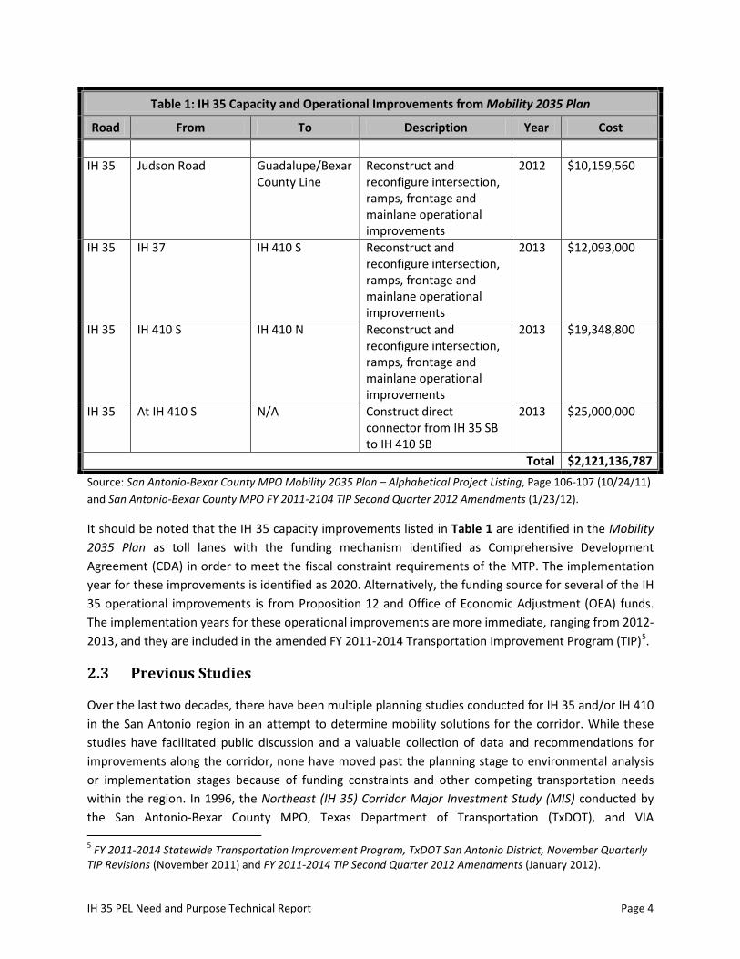
The San Antonio-Bexar County Metropolitan Planning Organization (MPO) is responsible for long-range transportation planning in the greater San Antonio metropolitan area. Their most recent Metropolitan Transportation Plan (MTP) is the San Antonio-Bexar County MPO Mobility 2035 Plan. This multi-modal plan forecasts population and employment growth and transportation needs and solutions based on that growth for the next 25 years. The Mobility 2035 Plan also communicates the region’s transportation vision, goals and strategies for surface modes of transportation. The project list is constrained by the amount of funding that is anticipated to be available to the region over the life of the plan, and the plan identifies over $11.5 billion in funded transportation improvements for the region over the 2010-2035 time period2. Among these improvements, the Mobility 2035 Plan identifies the need for additional roadway capacity in the IH 35 PEL project area along IH 35 from Schertz Parkway to IH 37/US 281 in downtown San Antonio. Additionally, the plan lists operational improvements planned on IH 35 from FM 3009 to Judson Road and from IH 410 N to IH 37, including a direct connector at IH 35 and IH 410 S. These IH 35 improvements total over $2.1 billion in estimated cost. There is only one planned improvement for the section of existing IH 410 located in the Study Area, which involves the installation of a concrete median barrier and illumination enhancements from IH 35N to IH 10E3. Table 1 below summarizes the major capacity and operational improvements4 to IH 35 that are contained in the Mobility 2035 Plan and subsequent revisions.
Table 1: IH 35 Capacity and Operational Improvements from Mobility 2035 Plan
Road From To Description Year Cost
Capacity Improvements IH 35 0.3 Mi N of
Randolph Blvd 0.2 Mi S of Schertz Pkwy
Expand from 8 to 14 lanes, including direct connectors at Loop 1604
2020 $1,018,355,254
IH 35 0.5 Mi S of Binz Engleman
0.3 Mi N of Randolph Blvd
Expand from 6 to 12 lanes, including direct connectors at IH 410 S and IH 410 N
2020 $688,144,172
IH 35 US 281/IH 37 0.5 Mi S of Binz Engleman
Expand from 6 to 10 lanes
2020 $335,546,368
Operational Improvements IH 35 Bexar/Guadalupe
County Line FM 3009 Reconstruct and
reconfigure intersection, ramps, frontage and mainlane operational improvements
2012 $12,489,633
2 Mobility 2035 Plan, Page ES-12. San Antonio-Bexar County MPO (2009). 3 FY 2011-2014 STIP, TxDOT San Antonio District February Quarterly Revisions. 4 In addition to the major IH 35 capacity and operational improvements listed in Table 1, there are several other minor projects (e.g., installation of illumination on IH 35 at IH 37 and around Rittiman Rd.) located in the Study Area. These have been omitted from Table 1 since they would have a minimal impact on mobility.
IH 35 PEL Need and Purpose Technical Report Page 4
Table 1: IH 35 Capacity and Operational Improvements from Mobility 2035 Plan
Road From To Description Year Cost
IH 35 Judson Road Guadalupe/Bexar
County Line Reconstruct and reconfigure intersection, ramps, frontage and mainlane operational improvements
2012 $10,159,560
IH 35 IH 37 IH 410 S Reconstruct and reconfigure intersection, ramps, frontage and mainlane operational improvements
2013 $12,093,000
IH 35 IH 410 S IH 410 N Reconstruct and reconfigure intersection, ramps, frontage and mainlane operational improvements
2013 $19,348,800
IH 35 At IH 410 S N/A Construct direct connector from IH 35 SB to IH 410 SB
2013 $25,000,000
Total $2,121,136,787 Source: San Antonio-Bexar County MPO Mobility 2035 Plan – Alphabetical Project Listing, Page 106-107 (10/24/11) and San Antonio-Bexar County MPO FY 2011-2104 TIP Second Quarter 2012 Amendments (1/23/12).
It should be noted that the IH 35 capacity improvements listed in Table 1 are identified in the Mobility 2035 Plan as toll lanes with the funding mechanism identified as Comprehensive Development Agreement (CDA) in order to meet the fiscal constraint requirements of the MTP. The implementation year for these improvements is identified as 2020. Alternatively, the funding source for several of the IH 35 operational improvements is from Proposition 12 and Office of Economic Adjustment (OEA) funds. The implementation years for these operational improvements are more immediate, ranging from 2012-2013, and they are included in the amended FY 2011-2014 Transportation Improvement Program (TIP)5.
2.3 Previous Studies
Over the last two decades, there have been multiple planning studies conducted for IH 35 and/or IH 410 in the San Antonio region in an attempt to determine mobility solutions for the corridor. While these studies have facilitated public discussion and a valuable collection of data and recommendations for improvements along the corridor, none have moved past the planning stage to environmental analysis or implementation stages because of funding constraints and other competing transportation needs within the region. In 1996, the Northeast (IH 35) Corridor Major Investment Study (MIS) conducted by the San Antonio-Bexar County MPO, Texas Department of Transportation (TxDOT), and VIA 5 FY 2011-2014 Statewide Transportation Improvement Program, TxDOT San Antonio District, November Quarterly TIP Revisions (November 2011) and FY 2011-2014 TIP Second Quarter 2012 Amendments (January 2012).

IH 35 PEL Need and Purpose Technical Report Page 5
Metropolitan Transit (VIA) recommended major capacity and operational improvements to IH 35. In addition to the 1996 MIS, there have been several other planning studies initiated in subsequent years related to IH 35 and IH 410 in San Antonio. A brief summary of the MIS and listing of the other previous studies is included in Appendix A.
In addition to the MPO planning process and the MIS, the IH 35 Corridor Advisory Committee, a citizen-led needs-based planning entity responsible for long-range statewide planning in the IH 35 corridor, has identified several improvements relevant to the IH 35 PEL Study Area in their MY 35 Plan6. First, the MY 35 Plan recommends interchange improvements at IH 35/Loop 1604 and both IH 35/IH 410 interchanges on the north side of the San Antonio region, all of which are located in the IH 35 PEL Study Area. Additionally, the MY 35 Plan recommends expanding general IH 35 mainlane capacity to a minimum of eight lanes, in addition to constructing a managed lane in each direction for the entire section of IH 35 located in the IH 35 PEL Study Area and extending to south Austin.
3 The Need for Improvements to IH 35
This section examines the current and future conditions in and around the Study Area which support the need for improvements in the IH 35 corridor, focusing on population, traffic, safety, and roadway design. The issues discussed in this section are central to the need and purpose of the IH 35 PEL study. Further discussion of some of the issues raised in this section and proposed solutions from the 1996 MIS and current stakeholder groups is provided in Section 4 and Appendix B.
3.1 Population
Over the past twenty years, the Greater San Antonio Metropolitan area, including the counties of Bexar, Comal, and Guadalupe, has experienced substantial population growth. This growth has outpaced major transportation improvements in the region and has resulted in worsening congestion in and around the Study Area; furthermore, this growth is forecast to continue into the future. This section presents a historical overview of population characteristics in the Study Area counties and future projections for growth, which form the underlying basis of the need and purpose of the IH 35 PEL study.
Historical Population Trends
As noted previously, the Study Area for the IH 35 PEL study travels through portions of Bexar, Comal, and Guadalupe Counties. Population data are presented at the county-level in this section for each county in the Study Area. As shown in Table 2, the three Study Area counties added over 650,000 residents between 1990 and 2010, equating to a 50.1% increase in population.
6 MY 35 Plan, IH 35 Corridor Advisory Committee (August, 2011).

IH 35 PEL Need and Purpose Technical Report Page 6
Table 2: Past and Present Population in the IH 35 PEL Study Area Counties
County 1990 2000 2010 Total Change (1990-2010)
Percent Change (1990-2010)
Bexar 1,185,394 1,392,931 1,714,773 529,379 44.7% Comal 51,832 78,021 108,472 56,640 109.3% Guadalupe 64,873 89,023 131,533 66,660 102.8%
Total 1,302,099 1,559,975 1,954,778 652,679 50.1% Source: U.S. Census Bureau (1990, 2000, 2010).
From an absolute perspective, Bexar County added the majority of residents during this time period, with over 529,000 people added between 1990 and 2010, representing a 44.7% increase in population for the county. From a relative perspective, both Comal and Guadalupe County more than doubled in size during the 1990 to 2010 time period, with 109.3% and 102.8% increases in population, respectively. For comparison purposes, the population in the entire state of Texas grew by approximately 48% and the population of the United States increased by 24.1% during the 1990-2010 time period7.
Future Population Projections
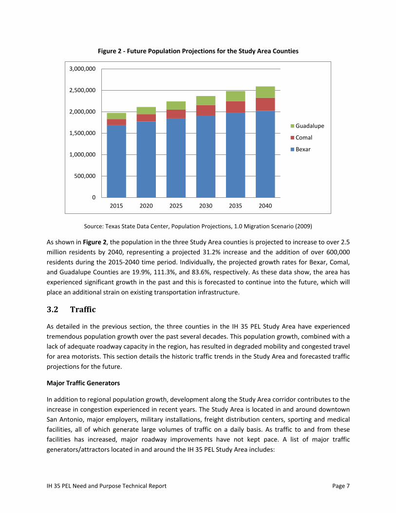
The Texas State Data Center (TxSDC) calculates future population projections at the county and statewide-level in single-year increments to the year 2040. Several projection scenarios are available based on different assumptions regarding growth and migration rates. The latest TxSDC population projections were calculated in 2008 and released in early 20098. Typically, TxSDC recommends utilizing the 0.5 migration scenario for long-range planning efforts, as this represents half of the migration rate that was experienced during the 1990-2000 time period, a period of high growth for many Texas counties. However, because of the high growth that has been experienced in the IH 35 PEL Study Area counties (Bexar, Comal, Guadalupe), utilizing the 0.5 migration scenario would provide 2020 population estimates that are less than the 2010 actual Census counts. As a result, the 1.0 migration scenario projections are presented in this section. Figure 2 below shows the projected population growth for Bexar, Comal and Guadalupe Counties from 2015 to 2040, in five-year increments.
7 U.S. Census Bureau. Official 1990 and 2010 Population Counts for the United States and State of Texas. 8 Texas State Data Center. Projections of the Population of Texas and Counties in Texas by Age, Sex and Race/Ethnicity for 2000-2040 (February 2009).
IH 35 PEL Need and Purpose Technical Report Page 7
Figure 2 - Future Population Projections for the Study Area Counties
Source: Texas State Data Center, Population Projections, 1.0 Migration Scenario (2009)
As shown in Figure 2, the population in the three Study Area counties is projected to increase to over 2.5 million residents by 2040, representing a projected 31.2% increase and the addition of over 600,000 residents during the 2015-2040 time period. Individually, the projected growth rates for Bexar, Comal, and Guadalupe Counties are 19.9%, 111.3%, and 83.6%, respectively. As these data show, the area has experienced significant growth in the past and this is forecasted to continue into the future, which will place an additional strain on existing transportation infrastructure.
3.2 Traffic
As detailed in the previous section, the three counties in the IH 35 PEL Study Area have experienced tremendous population growth over the past several decades. This population growth, combined with a lack of adequate roadway capacity in the region, has resulted in degraded mobility and congested travel for area motorists. This section details the historic traffic trends in the Study Area and forecasted traffic projections for the future.
Major Traffic Generators
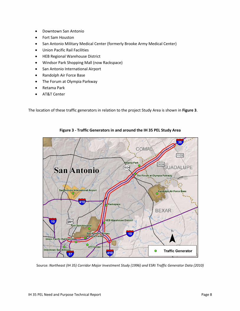
In addition to regional population growth, development along the Study Area corridor contributes to the increase in congestion experienced in recent years. The Study Area is located in and around downtown San Antonio, major employers, military installations, freight distribution centers, sporting and medical facilities, all of which generate large volumes of traffic on a daily basis. As traffic to and from these facilities has increased, major roadway improvements have not kept pace. A list of major traffic generators/attractors located in and around the IH 35 PEL Study Area includes:
0
500,000
1,000,000
1,500,000
2,000,000
2,500,000
3,000,000
2015 2020 2025 2030 2035 2040
Guadalupe
Comal
Bexar
IH 35 PEL Need and Purpose Technical Report Page 8
• Downtown San Antonio • Fort Sam Houston • San Antonio Military Medical Center (formerly Brooke Army Medical Center) • Union Pacific Rail Facilities • HEB Regional Warehouse District • Windsor Park Shopping Mall (now Rackspace) • San Antonio International Airport • Randolph Air Force Base • The Forum at Olympia Parkway • Retama Park • AT&T Center
The location of these traffic generators in relation to the project Study Area is shown in Figure 3.
Figure 3 - Traffic Generators in and around the IH 35 PEL Study Area
Source: Northeast (IH 35) Corridor Major Investment Study (1996) and ESRI Traffic Generator Data (2010)

IH 35 PEL Need and Purpose Technical Report Page 9
Historical Traffic Trends
As might be expected, because of the high rate of population growth in the region and major traffic generators located in and around the Study Area, traffic volumes in the corridor have increased significantly over the past two decades. Table 3 presents traffic counts from five locations along the study corridor from 1990, 2000, and 2010. These locations are depicted graphically in Figure 4. As shown in Table 3, traffic has increased from between 36% to 200% at the locations along the corridor during the last twenty years. This fact coupled with no major increase in roadway capacity has equated to gridlock at many locations along the corridor.
Table 3: Historical Traffic Counts at Locations along the IH 35 PEL Study Area Corridor
Location Description 1990 2000 2010 Total Increase (1990-2010)
% Increase (1990-2010)
1 IH 35 east of IH 37/281 111,000 159,000 151,000 40,000 36% 2 IH 35 south of Rittiman 127,000 169,000 181,000 54,000 43% 3 IH 35 north of IH 410W 120,000 169,000 200,000 80,000 67% 4 IH 35 northeast of Lp 1604 53,000 105,000 159,000 106,000 200% 5 IH 410 north of IH 10 52,000 69,000 80,000 28,000 54%
Source: TxDOT Transportation Planning and Programming Division, 1990-2010 Traffic Counts, ADT Volumes.
Within the Study Area, 2010 truck volumes represented approximately 8-10% of the total average daily traffic volume on IH 35, ranging from 9,000 to 14,000 trucks per day9. Trucks present additional capacity and safety concerns as they physically consume more capacity on the roadway than passenger vehicles and can make driving conditions more challenging for all motorists because their large size impairs other drivers’ view of the roadway and they are often moving slower than passenger vehicles.
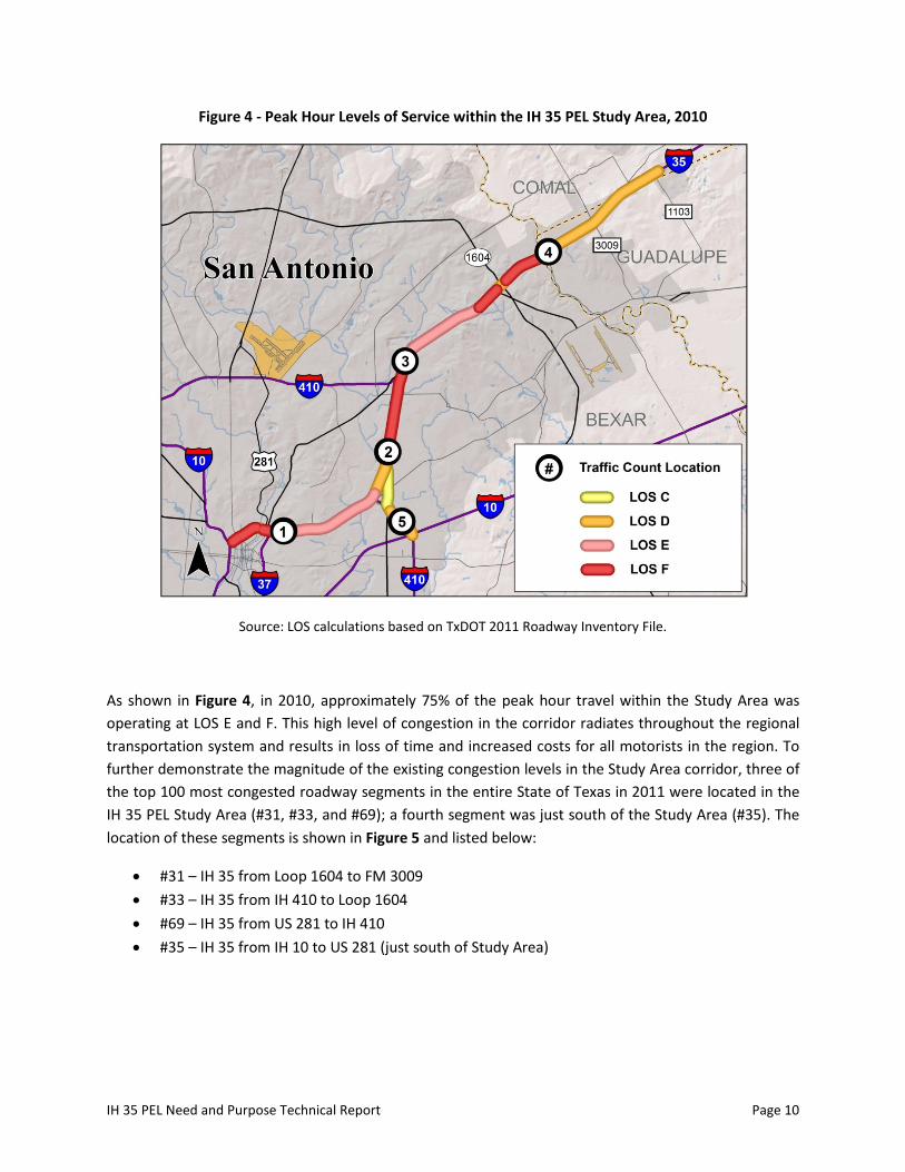
In order to determine whether roadway capacity is adequate to accommodate efficient travel, overall traffic volumes must be compared to available roadway capacity. The most common indicator of roadway efficiency is Level of Service (LOS). LOS is a measure of operational conditions along a roadway section during peak travel hours (generally 7AM-9AM and from 4PM-6PM). LOS is reported on a scale of A through F, with LOS A indicating free-flow travel conditions with gradually declining conditions through LOS F. Figure 4 presents the peak hour LOS in 2010 for the sections of IH 35 and IH 410 in the IH 35 PEL Study Area.
9 TxDOT Transportation Planning and Programming Division. 2010 Year End Roadway Inventory File.
IH 35 PEL Need and Purpose Technical Report Page 10
Figure 4 - Peak Hour Levels of Service within the IH 35 PEL Study Area, 2010
Source: LOS calculations based on TxDOT 2011 Roadway Inventory File.
As shown in Figure 4, in 2010, approximately 75% of the peak hour travel within the Study Area was operating at LOS E and F. This high level of congestion in the corridor radiates throughout the regional transportation system and results in loss of time and increased costs for all motorists in the region. To further demonstrate the magnitude of the existing congestion levels in the Study Area corridor, three of the top 100 most congested roadway segments in the entire State of Texas in 2011 were located in the IH 35 PEL Study Area (#31, #33, and #69); a fourth segment was just south of the Study Area (#35). The location of these segments is shown in Figure 5 and listed below:
• #31 – IH 35 from Loop 1604 to FM 3009 • #33 – IH 35 from IH 410 to Loop 1604 • #69 – IH 35 from US 281 to IH 410 • #35 – IH 35 from IH 10 to US 281 (just south of Study Area)

IH 35 PEL Need and Purpose Technical Report Page 11
Figure 5 - TxDOT Most Congested Roadways List in Texas
Source: TxDOT’s 100 Most Congested Roadways List for 2011 (released 2012)
As a result of the increasing congestion in the Study Area corridor, travel times have increased for residents in the Study Area counties. In 2008, over 265,000 workers in Bexar, Comal, and Guadalupe Counties traveled 30 minutes or longer to work10. As shown in Figure 6, the percentage of workers with commute travel times of less than 15 minutes and 15-29 minutes have decreased substantially from 1990-2008, whereas the percentage of workers with commutes taking 30-59 minutes and greater than 60 minutes have increased.
10 US Census Bureau, American Community Survey, 2005-2009

IH 35 PEL Need and Purpose Technical Report Page 12
Figure 6 - Travel Time to Work in Bexar, Guadalupe, and Comal Counties for 1990 and 2008
Source: U.S. Census Bureau 1990 and American Community Survey 2005-2009.
The impact of increased congestion and travel time in the region has a tangible effect from both an economic and a quality of life standpoint for all area residents and travelers. It is estimated that in 2010, the average annual delay per commuter was 30 hours during the peak period, which equates to over an entire day stuck in congestion out of the year. Additionally, the average peak period commuter consumed an excess of 9 gallons of gas and the total congestion cost per peak period auto commuter was $59111.
Future Traffic Projections
As might be expected, the traffic volumes on existing IH 35 and IH 410 in the Study Area are expected to increase over the planning horizon of the study. As shown in Table 4, the No-Build traffic volumes on IH 35 and IH 410 are expected to increase from current levels by 20.4% to 77.5% at various locations throughout the Study Area by 2035.
Table 4: 2035 Traffic Forecast for the IH 35 PEL Study Area (No-Build)
Location Description 2010 Traffic Volume
2035 Traffic Forecast
% Increase (2010 to 2035)
1 IH 35 east of IH 37/US 281 151,000 208,000 37.7% 2 IH 35 south of Rittiman Road 181,000 218,000 20.4% 3 IH 35 north of IH 410W 200,000 297,000 48.5% 4 IH 35 northeast of LP 1604 159,000 242,000 52.2% 5 IH 410 north of IH 10 80,000 142,000 77.5%
Source: TxDOT Transportation Planning and Programming Division, 2010 Traffic Counts, ADT Volumes; and IH 35 PEL Study Team Modeling Data. See Figure 4 for traffic count locations.
11 Texas Transportation Institute, 2011 Urban Mobility Report, Performance Measure Summary – San Antonio, TX
0%5%
10%15%20%25%30%35%40%45%50%
Worked fromHome
< 15 min. 15-29 min. 30-59 min. ≥ 60 min.
1990
2008
IH 35 PEL Need and Purpose Technical Report Page 13
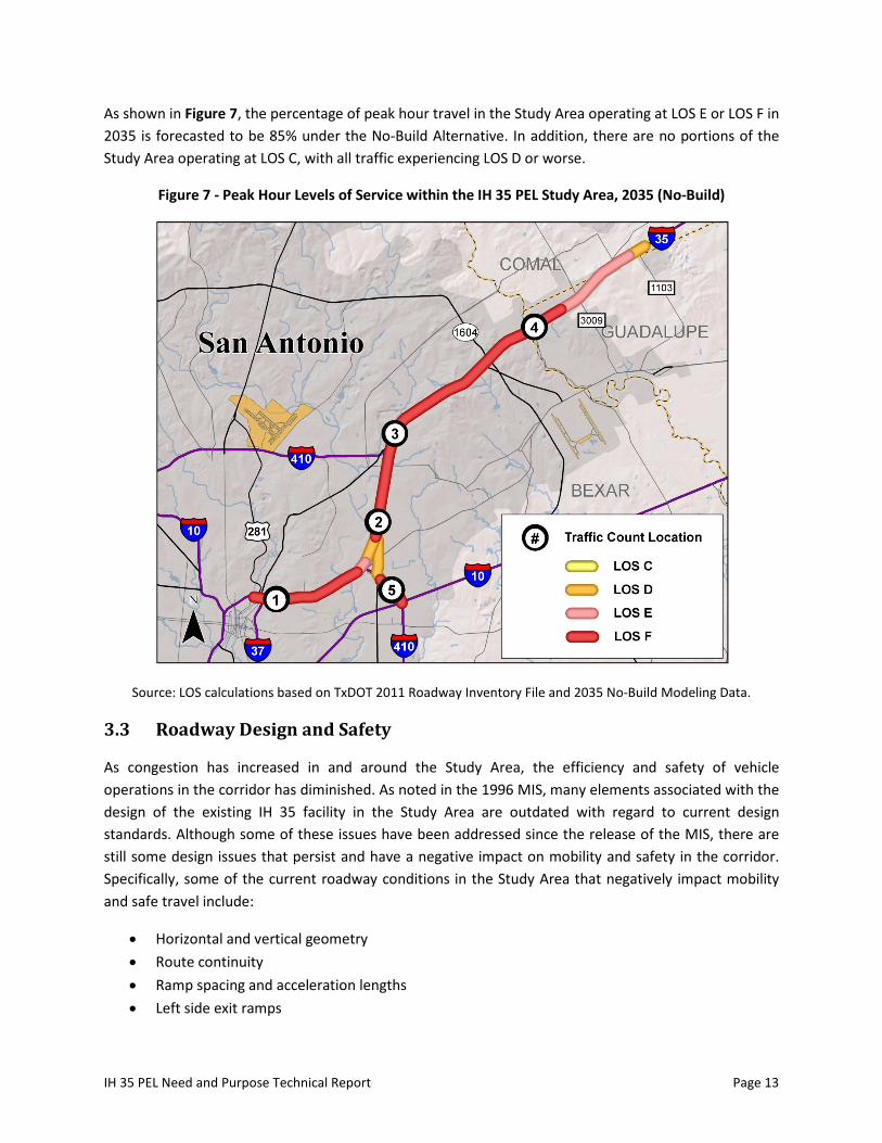
As shown in Figure 7, the percentage of peak hour travel in the Study Area operating at LOS E or LOS F in 2035 is forecasted to be 85% under the No-Build Alternative. In addition, there are no portions of the Study Area operating at LOS C, with all traffic experiencing LOS D or worse.
Figure 7 - Peak Hour Levels of Service within the IH 35 PEL Study Area, 2035 (No-Build)
Source: LOS calculations based on TxDOT 2011 Roadway Inventory File and 2035 No-Build Modeling Data.
3.3 Roadway Design and Safety
As congestion has increased in and around the Study Area, the efficiency and safety of vehicle operations in the corridor has diminished. As noted in the 1996 MIS, many elements associated with the design of the existing IH 35 facility in the Study Area are outdated with regard to current design standards. Although some of these issues have been addressed since the release of the MIS, there are still some design issues that persist and have a negative impact on mobility and safety in the corridor. Specifically, some of the current roadway conditions in the Study Area that negatively impact mobility and safe travel include:
• Horizontal and vertical geometry • Route continuity • Ramp spacing and acceleration lengths • Left side exit ramps
IH 35 PEL Need and Purpose Technical Report Page 14
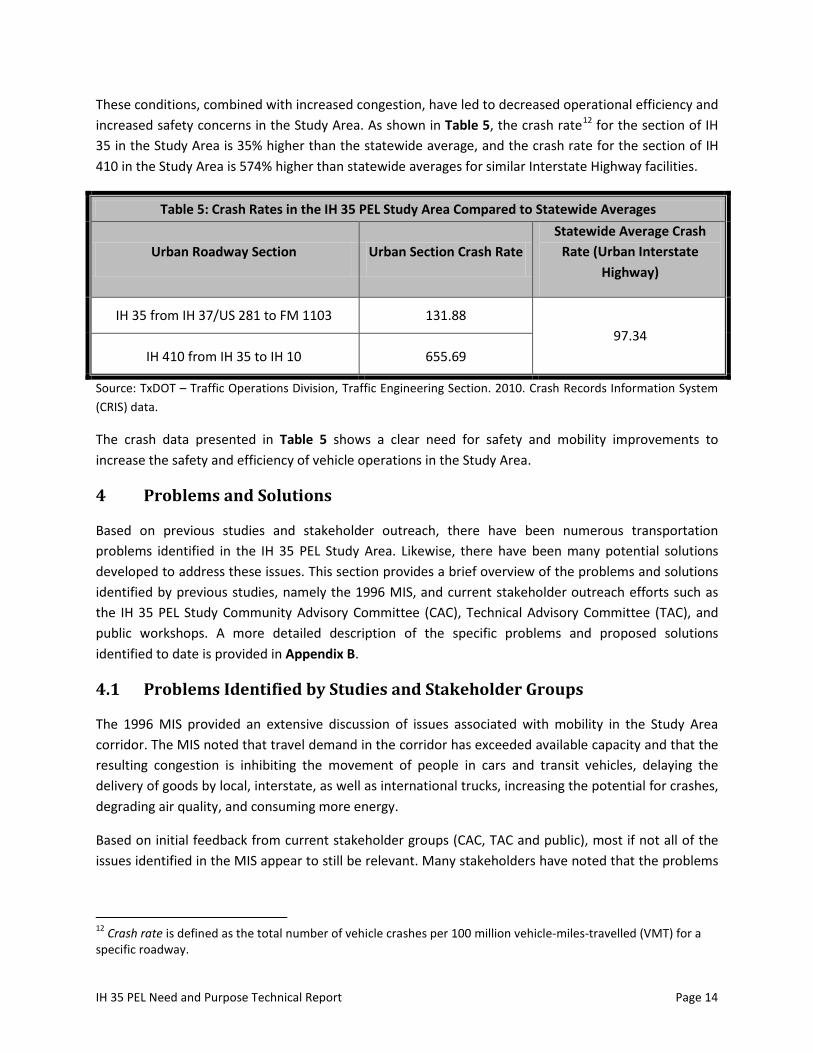
These conditions, combined with increased congestion, have led to decreased operational efficiency and increased safety concerns in the Study Area. As shown in Table 5, the crash rate12 for the section of IH 35 in the Study Area is 35% higher than the statewide average, and the crash rate for the section of IH 410 in the Study Area is 574% higher than statewide averages for similar Interstate Highway facilities.
Table 5: Crash Rates in the IH 35 PEL Study Area Compared to Statewide Averages
Urban Roadway Section Urban Section Crash Rate Statewide Average Crash
Rate (Urban Interstate Highway)
IH 35 from IH 37/US 281 to FM 1103 131.88 97.34
IH 410 from IH 35 to IH 10 655.69
Source: TxDOT – Traffic Operations Division, Traffic Engineering Section. 2010. Crash Records Information System (CRIS) data.
The crash data presented in Table 5 shows a clear need for safety and mobility improvements to increase the safety and efficiency of vehicle operations in the Study Area.
4 Problems and Solutions
Based on previous studies and stakeholder outreach, there have been numerous transportation problems identified in the IH 35 PEL Study Area. Likewise, there have been many potential solutions developed to address these issues. This section provides a brief overview of the problems and solutions identified by previous studies, namely the 1996 MIS, and current stakeholder outreach efforts such as the IH 35 PEL Study Community Advisory Committee (CAC), Technical Advisory Committee (TAC), and public workshops. A more detailed description of the specific problems and proposed solutions identified to date is provided in Appendix B.
4.1 Problems Identified by Studies and Stakeholder Groups
The 1996 MIS provided an extensive discussion of issues associated with mobility in the Study Area corridor. The MIS noted that travel demand in the corridor has exceeded available capacity and that the resulting congestion is inhibiting the movement of people in cars and transit vehicles, delaying the delivery of goods by local, interstate, as well as international trucks, increasing the potential for crashes, degrading air quality, and consuming more energy.
Based on initial feedback from current stakeholder groups (CAC, TAC and public), most if not all of the issues identified in the MIS appear to still be relevant. Many stakeholders have noted that the problems
12 Crash rate is defined as the total number of vehicle crashes per 100 million vehicle-miles-travelled (VMT) for a specific roadway.

IH 35 PEL Need and Purpose Technical Report Page 15
have increased in magnitude since the MIS was completed. Therefore, the MIS provides a valuable resource for information relevant to the current IH 35 PEL study.
4.2 Project Goals/Objectives and Potential Solutions
Goals and objectives for improving IH 35 in the Study Area were established to help define the direction of the study and to serve as a point of reference during the development and evaluation of potential solutions. Project goals/objectives developed in the MIS and reaffirmed by the current stakeholder groups include:
• Improve Mobility • Achieve Project Affordability and Constructability • Improve Safety • Achieve Environmental and Air Quality Benefits • Maximize Use of Existing Right of Way • Promote Economic Development • Achieve Land Use Benefits • Gain Public Support
To address the transportation problems in the corridor, the MIS and project stakeholders have proposed various preliminary solutions including combinations of major capacity, design, safety, operational, and modal improvements. These are discussed further in Appendix B.
5 Conclusion
After reviewing the current and future projected conditions in the IH 35 PEL Study Area and the current issues associated with efficient and safe transportation operations within the corridor, it is evident that major transportation improvements are needed in the Study Area in order to enhance and preserve mobility for the future. As such, the IH 35 PEL project is needed primarily to address the following issues in the Study Area:
• Increasing traffic demand and congestion • Inadequate roadway capacity • Roadway safety and operational concerns • Structural and functional roadway deficiencies • Limited integration of IH 35 with other existing and planned transportation modes
The aforementioned need and purpose statement, along with project goals, objectives, and issues identified to date, should be utilized when developing and screening project-level alternatives for the IH 35 PEL study to ensure that the most pressing transportation issues are being addressed by any proposed improvement projects.

APPENDIX A - SUMMARY OF MIS
AND LISTING OF PREVIOUS PLANNING STUDIES

Draft IH 35 PEL Need and Purpose Technical Report Page A-1
Summary of MIS and Listing of Previous Planning Studies
Northeast (IH 35) Corridor Major Investment Study Technical Report (1996)
The Northeast (IH 35) Corridor Major Investment Study was sponsored by the San Antonio-Bexar County
MPO and performed in collaboration with TxDOT and VIA in 1996. The project Study Area extended
along IH 35 from IH 37 in downtown San Antonio to Loop 1604 in northeastern Bexar County. It also
included the IH 410 roadway segment that connects IH 35 to IH 10. The MIS evaluated the
transportation issues in the corridor and determined that “travel demands on the corridor have
exceeded available capacity. The resulting congestion is inhibiting the movement of people in cars and
transit, delaying the delivery of goods by local, interstate, and international trucks, increasing the
potential for accidents, and consuming more energy13.” To address these issues, the MIS defined,
developed, and evaluated eight alternative strategies, which were divided into three categories:
Base Case – Maintain existing transportation system and near future committed improvements
Minimal Improvements – Minimal corridor operating system improvements and improved bus
service
Major Improvements – Safety and operations improvements at major interchanges
The MIS then identified a Locally Preferred Alternative which incorporated elements of several
alternative strategies and included major capacity improvements to IH 35. Specifically, the Locally
Preferred Alternative involved improving the section to six general purpose freeway lanes and four
barrier-separated special purpose lanes. The four special purpose lanes would consist of one express
lane and one diamond marked HOV lane in each direction. It was believed that this alternative would
provide an incentive for commuters to car pool or use transit, allow for congestion pricing (or the sale of
excess capacity), and channel the through movement traffic efficient from Loop 1604 to downtown San
Antonio.
Although the MIS provided extensive analysis of the underlying transportation issues associated with the
corridor and provided several potential solutions, no major capacity improvements and only minor
operational improvements have been implemented in the corridor since the study was released,
primarily because of funding constraints. In many ways, the same problems identified by the MIS still
exist today, with the only difference being they are much more severe than in 1996. Thus, many
elements of the need and purpose identified in the MIS are still relevant and will be built upon and
updated in the current PEL study. A more detailed discussion of specific issues, problems, and solutions
identified in the corridor by the MIS, along with elements of the project need and purpose statement,
are provided in Appendix B.
13
Northeast (IH 35) Corridor Major Investment Study, Page 1-1. San Antonio-Bexar County MPO (1996).

Draft IH 35 PEL Need and Purpose Technical Report Page A-2
Other Previous Studies (2000-2010)
In addition to the 1996 MIS, there have been numerous other studies that have been performed in
recent years related to this section of the IH 35 and/or IH 410 corridor(s). A listing of these studies (in
chronological order beginning with the most recent) is provided below:
1. IH 35 Corridor Level-2 Tolled Lanes Planning Study, Draft Final Report, 2010, for the Alamo RMA
and TxDOT-TTA, by Rodriguez Transportation Group
2. IH 35 Managed Lanes Project, Initial Conceptual Alternatives Studies (Phase 1), From:
Bexar/Guadalupe County Line, To: US 281, Bexar County, Texas, for the Alamo RMA, by HNTB.
This series of studies included:
o IH 35 Environmental Constraints DRAFT, March 2007
o Conceptual Drainage Assessment Technical Memorandum DRAFT, March 2007
o Initial Screening of Conceptual Alternatives Technical Memorandum DRAFT, revised May
11, 2007
o Traffic Demand Modeling Technical Memorandum DRAFT, March 2007
o Draft Utilities Mapping, 2007
o Draft Right of Way Mapping, 2007
o Conceptual Schematic Drawings, 2007
3. San Antonio I-35 Northeast Corridor Value Pricing Study, 2005, for Texas Department of
Transportation and Federal Highway Administration, by the Texas Transportation Institute
4. IH 35 San Antonio Northeast Corridor From IH 37/US 281 to Loop 1604, IH 35 at Loop 1604
Interchange, Interchange Study, January 2003, for Texas Department of Transportation San
Antonio District, by Rodriguez Transportation Group
5. IH 35 (San Antonio) Comparison of Existing and Proposed Traffic Patterns, by Carter Burgess,
January 8, 2003
6. IH 35 San Antonio Northeast Corridor Schematic Design Study, Managed Lanes At-Grade in
Median Area, From IH 410 North to IH 410 South, Prepared for Texas Department of
Transportation San Antonio District, Prepared by Carter & Burgess, Inc., December 2002
7. IH 35 San Antonio Northeast Corridor, From IH 37/US 281 to Loop 1604, Evaluation of Railroad
Grade Separations at Walzem, Eisenhauer and Rittiman with Intersection of the Union Pacific
Railroad, Prepared for Texas Department of Transportation San Antonio District, Prepared by
Carter & Burgess, Inc., December 2002
8. IH 35 San Antonio Northeast Corridor, From IH 37/US 281 to Loop 1604, Evaluation of Minimum
Right-of-Way Requirements, IH 37/US 281 to Loop 410 North, Prepared for Texas Department of
Transportation San Antonio District, Prepared by Carter & Burgess, Inc., December 2002
9. IH 35 San Antonio Northeast Corridor Traffic Report, Operational Analysis Performed on the Lane
Arrangement Concepts, Prepared for Texas Department of Transportation San Antonio District,
by Carter & Burgess, Inc., November 2001

Draft IH 35 PEL Need and Purpose Technical Report Page A-3
10. IH 35 San Antonio Northeast Corridor Traffic Report, Travel Demand Model Activities Performed
on the Lane Arrangement Concepts, Prepared for Texas Department of Transportation San
Antonio District, and Carter & Burgess, Inc., Prepared by: Alliance-Texas Engineering Company,
Austin, Texas, November 2001
11. IH 35 Traffic Impact Assessment, Transportation Analysis for the IH 35 Corridor, Prepared for
Texas Department of Transportation San Antonio District, Prepared by Carter & Burgess, Inc.,
January 2001
12. IH 35 San Antonio Operational Analysis Travel Modeling, Travel demand model activities
performed for the IH 35 Corridor, From: Olympia To: US 281, and IH 410 From: IH 35 To: IH 10,
Sponsors: Carter & Burgess, Inc. and Texas Department of Transportation San Antonio District,
Prepared by: Alliance-Texas Engineering Company, Austin, Texas, February 15, 2000
The volume of previous analyses that have been performed for this corridor further highlights the
intense need for improvement in this critical corridor. As with the 1996 MIS, regional funding constraints
have prevented any of the previous studies from advancing past the planning stage and into the
implementation phase with regard to any significant capacity improvements.

APPENDIX B – SUMMARY OF PROBLEMS AND SOLUTIONS
IDENTIFIED BY MIS AND CURRENT STAKEHOLDERS
Draft IH 35 PEL Need and Purpose Technical Report Page B-1
Summary of Problems and Solutions Identified by MIS and Current
Stakeholders
Issues Identified in MIS
The 1996 MIS provides an extensive discussion of issues associated with mobility in the Study Area
corridor. The MIS noted that travel demand in the corridor has exceeded available capacity and that the
resulting congestion is inhibiting the movement of people in cars and transit vehicles, delaying the
delivery of goods by local, interstate, as well as international trucks, increasing the potential for crashes,
degrading air quality, and consuming more energy. Specific problems identified by the MIS in the
corridor include:
Conflicts between local and thru traffic on Loop 410 and IH 35
Issues with left side freeway exit ramps
Traffic demand exceeds capacity on IH 35 and adjacent local street system
Congestion increases the potential for crashes
Poor pavement conditions on some sections of IH 35
Poor traffic flows at both interchanges between IH 35 and Loop 410
Lack of route and lane continuity on Loop 410
A high number of trucks use the corridor
Cars and trucks inhibit each other's movements
Limited transportation choices (modes) within the corridor
Existing Randolph “park and ride” lot not easily accessible
Limited bicycle and pedestrian facilities within the corridor
Air ambulance helipad directly adjacent to IH 35 may cause "rubbernecking"
Rail lines (at-grade) inhibit traffic at crossings on adjacent arterial streets
Increasing rail traffic in the corridor
Issues Identified by Current Stakeholder Groups
Based on initial feedback from the IH 35 PEL Study stakeholder groups (TAC and CAC) and the public, it
appears that many issues identified in the MIS are still present in the corridor; thus, much of the
previous analysis is still relevant. In addition to the problems previously identified in the MIS and listed
in the previous sections, other issues identified by the IH 35 PEL Study TAC and CAC include:
Concerns about increased traffic in Brooke Army Medical Center (BAMC) area (now San Antonio
Military Medical Center)
Choke points along corridor (at BAMC, Loop 1604, FM 3009, etc.)
Lack of alternate routes to IH 35 because other arterials have at-grade train crossings
Lack of connecting facilities or capacity on connecting facilities to IH 35
Not enough emphasis on mixed use development
Not enough transit coverage or options in the IH 35 corridor

Draft IH 35 PEL Need and Purpose Technical Report Page B-2
Traffic related to HEB distribution facility
Single lane exits causing congestion and traffic merging issues because of roadway geometry
Crash/incident clearance issues in the corridor
High volumes of truck traffic in the corridor impact mobility and safety
Inadequate storage capacity for both exit and merging lanes
Some other issues identified by the public in the first round of public workshops include:
Need to address traffic bottlenecks and merging issues at specific interchanges
Need for design, safety, and operational improvements such as adding, eliminating, or
improving direct connections and left-lane exits, addressing ramp lengths and curve angles, and
adding signage and traffic barriers
Concern related to integrity of the historical areas of IH 35
Concern related to drainage and flooding issues along the IH 35 frontage roads
Lack of support for improvements involving tolls
A full summary of all activities related to the first round of IH 35 PEL Public Workshops, including more
detailed results of public comments and suggestions are provided in the IH 35 PEL Study Public
Workshop Summary and Analysis Report – November 2011.
Project Goals/Objectives and Potential Solutions
In addition to identifying issues in the Study Area corridor, the current IH 35 PEL Study stakeholders
(TAC, CAC, and public) have helped develop a set of project goals/objectives and potential solutions
related to mobility in the IH 35 PEL Study Area. Note that these goals confirm those developed in the
MIS, and include:
Improve Mobility – a primary goal of this study is to enhance mobility and decrease travel times
within the corridor. Alternative improvement strategies should be developed to enhance
passenger capacity and convenience.
Achieve Project Affordability and Constructability – the alternative development strategies
should be cost effective and reasonable from a construction perspective.
Improve Safety – the study should identify and correct any design deficiencies associated with
the existing facility that have a negative impact on safe travel in the corridor.
Achieve Environmental and Air Quality Benefits – alternative improvement strategies should
facilitate reductions in vehicle congestion and emissions. In addition, such strategies should
identify, mitigate, or avoid adverse impacts on the surrounding natural environment and
existing communities.
Maximize Use of Existing Right of Way – alternative improvements strategies should make every
attempt to maximize the utilization of existing transportation rights of way.
Promote Economic Development – alternative improvement strategies should be evaluated for
their contribution to the corridor and the region’s economic growth and competitiveness.

Draft IH 35 PEL Need and Purpose Technical Report Page B-3
Achieve Land Use Benefits – alternative improvement strategies should promote more efficient
use of new and existing transportation capacity and be a catalyst for efficient land use and
development.
Gain Public Support – secure the support of the community when evaluating the proposed
alternative investment strategies that meet their transportation needs.
Some of the solutions developed to address the transportation issues in the corridor by the MIS and
identified by public and stakeholder involvement efforts include:
Address major traffic bottlenecks and choke points in the corridor
Implement design, safety, and operational improvements such as interchange direct
connections, merging lanes, turn-around lanes, and modified entrance/exit ramps
Consider expanded transit, bus, and pedestrian options that are better integrated with the
overall transportation system
Provide additional main lane capacity on IH 35 in the corridor
Provide additional High-Occupancy Toll (HOT), High-Occupancy Vehicle (HOV), or designated
truck-lane capacity in the corridor
Improve connecting or parallel transportation facilities to IH 35 to provide alternate routes of
travel
Implement Transportation Systems Management (TSM), Transportation Demand Management
(TDM), and/or Intelligent Transportation Systems (ITS) improvements in the corridor
Improve routing of hazardous materials in the corridor
A more detailed discussion of all potential solutions developed in the MIS and through public and
stakeholder involvement efforts can be found in the 1996 MIS14 and IH 35 PEL Study Public Workshop
Summary and Analysis Report – November 2011.
14
Northeast (IH 35) Corridor Major Investment Study. San Antonio-Bexar County MPO (1996).