NATIONAL SENIOR CERTIFICATE GRADE 12 GEOGRAPHY … P1 Eng Prep Ex… · Geography/P1 4...
23
Copyright reserved Please turn over MARKS: 300 TIME: 3 hours This question paper consists of 17 pages and an annexure of 6 pages. GEOGRAPHY P1 PREPARATORY EXAMINATION 2008 NATIONAL SENIOR CERTIFICATE GRADE 12
Transcript of NATIONAL SENIOR CERTIFICATE GRADE 12 GEOGRAPHY … P1 Eng Prep Ex… · Geography/P1 4...
Copyright reserved Please turn over
MARKS: 300 TIME: 3 hours
This question paper consists of 17 pages and an annexure of 6 pages.
GEOGRAPHY P1
PREPARATORY EXAMINATION 2008
NATIONAL SENIOR CERTIFICATE
GRADE 12
Geography/P1 2 DoE/Preparatory Examination 2008 NSC
Copyright reserved Please turn over
INSTRUCTIONS AND INFORMATION 1. This question paper consists of FOUR questions.
2. Answer ANY THREE questions of 100 marks each.
3. ALL diagrams are included in the ANNEXURE.
4. Number ALL your answers in the CENTRE of the line.
5. Leave a line between subsections answered.
6. Start EACH question at the top on a NEW page.
7. Number the answers correctly according to the numbering system used in this question paper.
8. Do NOT write in the margins of the ANSWER BOOK.
9. Where possible, illustrate your answers with labelled diagrams.
10. Write neatly and legibly.
Geography/P1 3 DoE/Preparatory Examination 2008 NSC
Copyright reserved Please turn over
SECTION A: CLIMATE AND WEATHER, FLUVIAL PROCESSES AND
STRUCTURAL LANDSCAPES
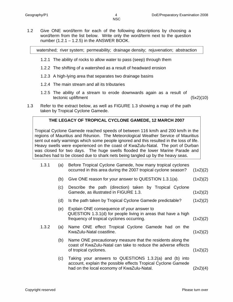
Answer at least ONE question from this section. QUESTION 1
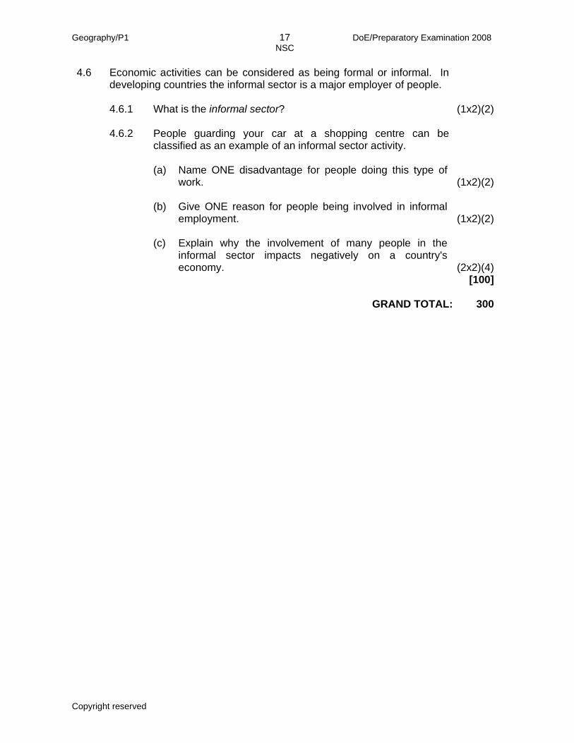
1.1 Refer to FIGURE 1.1 showing the tri-cellular arrangement of the atmosphere.
Various options are provided as possible answers to each of the following questions. Choose the answer and write only the letter (A – D) next to the question number (1.1.1 – 1.1.5) in the ANSWER BOOK, for example 1.1.6 B.
1.1.1 The front at A is known as the … front.
A tropical B mid-latitude C polar D moisture
1.1.2 The air circulation cell labelled B is the … cell.
A Hadley B Ferrel C polar D tropical
1.1.3 The surface air flow in the air circulatory cell labelled C is …
A convergence. B divergence. C uplift. D subsidence.
1.1.4 The … winds meet at D.
A polar easterly B tropical easterly C polar westerly D tropical westerly
1.1.5 At E there is a general … of air.
A subsidence and heating B rising and heating C subsidence and cooling D rising and cooling (5x2)(10)
Geography/P1 4 DoE/Preparatory Examination 2008 NSC
Copyright reserved Please turn over
1.2 Give ONE word/term for each of the following descriptions by choosing a word/term from the list below. Write only the word/term next to the question number (1.2.1 – 1.2.5) in the ANSWER BOOK.
watershed; river system; permeability; drainage density; rejuvenation; abstraction 1.2.1 The ability of rocks to allow water to pass (seep) through them
1.2.2 The shifting of a watershed as a result of headward erosion
1.2.3 A high-lying area that separates two drainage basins
1.2.4 The main stream and all its tributaries
1.2.5 The ability of a stream to erode downwards again as a result of
tectonic upliftment (5x2)(10) 1.3 Refer to the extract below, as well as FIGURE 1.3 showing a map of the path
taken by Tropical Cyclone Gamede.
THE LEGACY OF TROPICAL CYCLONE GAMEDE, 12 MARCH 2007
Tropical Cyclone Gamede reached speeds of between 116 km/h and 200 km/h in the regions of Mauritius and Réunion. The Meteorological Weather Service of Mauritius sent out early warnings which some people ignored and this resulted in the loss of life. Heavy swells were experienced on the coast of KwaZulu-Natal. The port of Durban was closed for two days. The huge swells flooded the lower Marine Parade and beaches had to be closed due to shark nets being tangled up by the heavy seas.
1.3.1 (a) Before Tropical Cyclone Gamede, how many tropical cyclones
occurred in this area during the 2007 tropical cyclone season? (1x2)(2) (b) Give ONE reason for your answer to QUESTION 1.3.1(a). (1x2)(2)
(c) Describe the path (direction) taken by Tropical Cyclone
Gamede, as illustrated in FIGURE 1.3. (1x2)(2) (d) Is the path taken by Tropical Cyclone Gamede predictable? (1x2)(2)
(e) Explain ONE consequence of your answer to QUESTION 1.3.1(d) for people living in areas that have a high
frequency of tropical cyclones occurring. (1x2)(2) 1.3.2 (a) Name ONE effect Tropical Cyclone Gamede had on the
KwaZulu-Natal coastline. (1x2)(2) (b) Name ONE precautionary measure that the residents along the
coast of KwaZulu-Natal can take to reduce the adverse effects of tropical cyclones. (1x2)(2)
(c) Taking your answers to QUESTIONS 1.3.2(a) and (b) into
account, explain the possible effects Tropical Cyclone Gamede had on the local economy of KwaZulu-Natal. (2x2)(4)
Geography/P1 5 DoE/Preparatory Examination 2008 NSC
Copyright reserved Please turn over
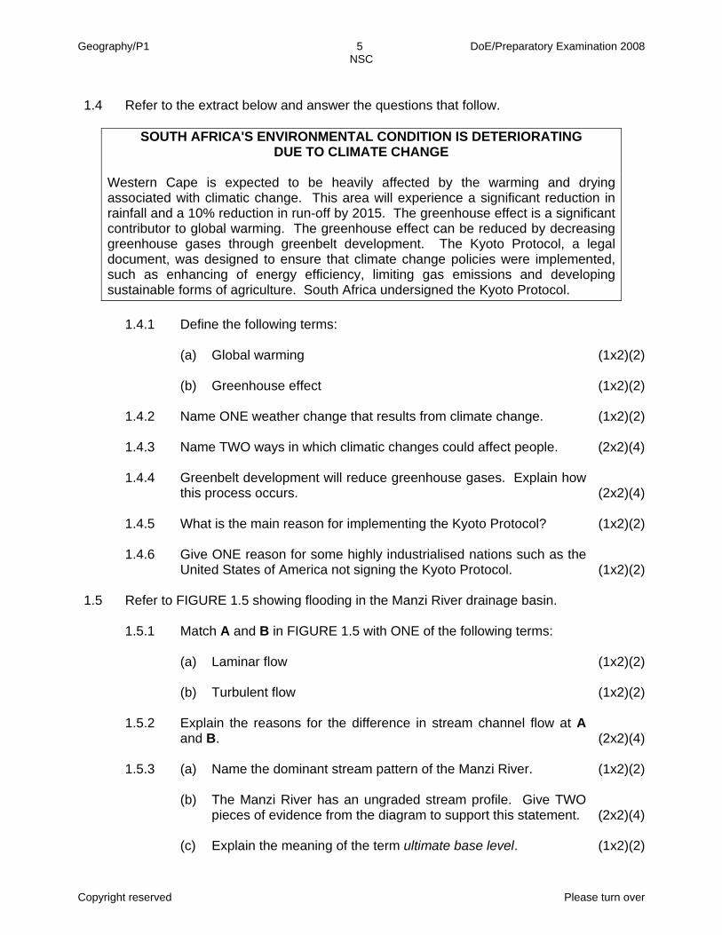
1.4 Refer to the extract below and answer the questions that follow.
SOUTH AFRICA'S ENVIRONMENTAL CONDITION IS DETERIORATING
DUE TO CLIMATE CHANGE
Western Cape is expected to be heavily affected by the warming and drying associated with climatic change. This area will experience a significant reduction in rainfall and a 10% reduction in run-off by 2015. The greenhouse effect is a significant contributor to global warming. The greenhouse effect can be reduced by decreasing greenhouse gases through greenbelt development. The Kyoto Protocol, a legal document, was designed to ensure that climate change policies were implemented, such as enhancing of energy efficiency, limiting gas emissions and developing sustainable forms of agriculture. South Africa undersigned the Kyoto Protocol.
1.4.1 Define the following terms:
(a) Global warming (1x2)(2)
(b) Greenhouse effect (1x2)(2)
1.4.2 Name ONE weather change that results from climate change. (1x2)(2)
1.4.3 Name TWO ways in which climatic changes could affect people. (2x2)(4)
1.4.4 Greenbelt development will reduce greenhouse gases. Explain how
this process occurs. (2x2)(4) 1.4.5 What is the main reason for implementing the Kyoto Protocol? (1x2)(2)
1.4.6 Give ONE reason for some highly industrialised nations such as the
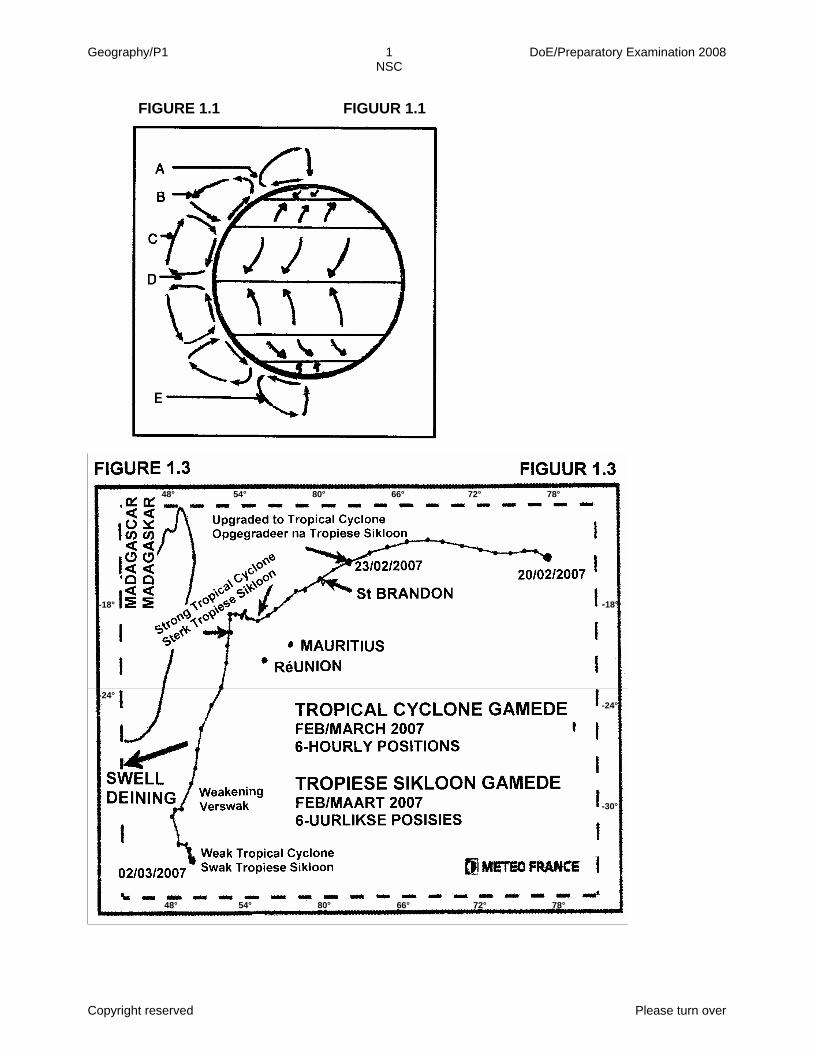
United States of America not signing the Kyoto Protocol. (1x2)(2) 1.5 Refer to FIGURE 1.5 showing flooding in the Manzi River drainage basin.
1.5.1 Match A and B in FIGURE 1.5 with ONE of the following terms:
(a) Laminar flow (1x2)(2)
(b) Turbulent flow (1x2)(2)
1.5.2 Explain the reasons for the difference in stream channel flow at A
and B. (2x2)(4) 1.5.3 (a) Name the dominant stream pattern of the Manzi River. (1x2)(2)
(b) The Manzi River has an ungraded stream profile. Give TWO
pieces of evidence from the diagram to support this statement. (2x2)(4) (c) Explain the meaning of the term ultimate base level. (1x2)(2)
Geography/P1 6 DoE/Preparatory Examination 2008 NSC
Copyright reserved Please turn over
1.5.4 (a) What was the extreme weather condition that resulted in the flooding of the Manzi River drainage basin? (1x2)(2)
(b) Name any TWO natural features of the drainage basin which
contributed to flooding. (2x2)(4) (c) Explain how the two natural features mentioned in QUESTION 1.5.4(b) contributed to flooding in the Manzi River
drainage basin. (2x2)(4) (d) Name THREE consequences of this flood for the people living
in the Manzi River drainage basin. (3x2)(6) (e) Explain TWO ways in which human intervention contributed to
the flooding in the urban settlement. (2x2)(4) (f) The introduction of early warning systems in the Manzi River
drainage basin could reduce the impact of flooding in future. Explain this statement. (2x2)(4)
(g) Explain the importance of proper drainage management in the
Manzi River drainage basin. (2x2)(4) [100]
QUESTION 2
2.1 Refer to FIGURE 2.1 showing the deflection of winds. Match each of the
letters A, B, C, D and E with ONE of the terms listed below. Write down only the letter (A – E) and next to it the correct term, for example G – Pressure cell.
• High pressure area
• Frictional force
• Low pressure area
• Convergence
• Geostrophic wind
• Pressure gradient force
• Coriolis force (5x2)(10)

Geography/P1 7 DoE/Preparatory Examination 2008 NSC
Copyright reserved Please turn over
2.2 Refer to FIGURE 2.2 showing a flow hydrograph. Choose a term/word from
COLUMN B that matches a description in COLUMN A. Write only the Roman numerals (i – vii) next to the question number (2.2.1 – 2.2.5) in the ANSWER BOOK, for example 2.2.6 (viii).
COLUMN A COLUMN B
2.2.1 2.2.2 2.2.3 2.2.4 2.2.5
The maximum run-off that will occur in the river (A) The maximum precipitation that will occur (B) Water that flows underground (C) Water that flows on the surface (D) Interval between the maximum rainfall and maximum run-off (E)
(i) (ii) (iii) (iv) (v) (vi) (vii)
lag time flood peak water table rainfall peak run-off bankfull stage base flow
(5x2)(10) 2.3 Refer to FIGURE 2.3 showing a synoptic weather map of Southern Africa for
16 November 2007. 2.3.1 (a) Identify the weather system labelled A. (1x2)(2)
(b) Weather system A has reached its occlusion stage (cold front
occlusion). Draw a clearly labelled cross-section of a cold front occlusion showing the position of the air masses and the cold and warm fronts. (3x2)(6)
2.3.2 (a) Name the high pressure systems labelled B and C
respectively. (2x2)(4) (b) Explain how high pressure system B influenced the weather
conditions over the Western Cape. (2x2)(4) 2.3.3 (a) Name the high pressure system often found over the interior of
South Africa. (1x2)(2) (b) Explain the effect that the high pressure system referred to in
QUESTION 2.3.3(a) has on rainfall on the plateau. (2x2)(4)
Geography/P1 8 DoE/Preparatory Examination 2008 NSC
Copyright reserved Please turn over
2.4 Refer to the extract below, FIGURE 2.3 and FIGURE 2.4, a synoptic weather
map and satellite image respectively.
COLD WEATHER SET TO CONTINUE OVER THE CAPE, 29 JUNE 2007
Another cold front is set to cause a continuation of very cold and wet conditions over the Western Cape. The South African Weather Service appeals to the public to forward any reports of heavy rain, damaging winds, hailstorms et cetera to them.
2.4.1 The position of the cold front in relation to South Africa in
FIGURE 2.4 is different to FIGURE 2.3. Make a sketch showing the position of the cold front in FIGURE 2.4, in relation to South Africa. (1x2)(2)
2.4.2 Name TWO weather conditions that resulted from the cold front. (2x2)(4)
2.4.3 These weather conditions, mentioned in QUESTION 2.4.2, have a
far greater effect on people living in the informal settlements of Cape Town than on those in the suburbs. Explain this statement. (2x2)(4)
2.5 Refer to FIGURE 2.5 showing a pollution dome over a large urban settlement.
2.5.1 During night-time the pollution dome is much lower than during day-
time. Give reasons why this is so. (2x2)(4) 2.5.2 State the environmental problem resulting from a pollution dome that
is situated closer to the earth's surface. (1x2)(2) 2.5.3 Name ONE way in which we can minimise the environmental
problem mentioned in QUESTION 2.5.2. (1x2)(2) 2.6 Refer to FIGURE 2.6 showing two drainage basins, A and B.
2.6.1 (a) Match drainage basins A and B with flow hydrographs 1 and 2. (2x2)(4)
(b) Give ONE reason for each of your choices made in
QUESTION 2.6.1(a). (2x2)(4) 2.6.2 (a) In which drainage basin is flooding more likely to occur? (1x2)(2)
(b) Give ONE reason for your answer to QUESTION 2.6.2(a). (1x2)(2)
Geography/P1 9 DoE/Preparatory Examination 2008 NSC
Copyright reserved Please turn over
2.7 Refer to FIGURE 2.7 showing a ridge labelled A.
2.7.1 (a) Identify the ridge labelled A. (1x2)(2)
(b) State ONE significance of ridge A to humans. (1x2)(2)
(c) Briefly explain the formation of ridge A. (3x2)(6)
2.7.2 Identify slopes B and C respectively. (2x2)(4) 2.7.3 Mesas will not develop in this landscape. Give a reason why this is
so. (1x2)(2) 2.8 Refer to the extract below and FIGURE 2.8, showing mass movement.
PEOPLE AND SLOPE FAILURE
All slopes are affected by gravity, by one or more of the several mass movement processes by which weathered material is transported downslope. Human activity, such as the extraction of a natural resource, urbanisation and recreation have all contributed to increased mass movement.
2.8.1 Explain the term mass movement. (1x2)(2)
2.8.2 Identify the type of mass movement that is taking place in
FIGURE 2.8. (1x2)(2) 2.8.3 Give ONE reason, visible in FIGURE 2.8, for your answer to
QUESTION 2.8.2. (1x2)(2) 2.8.4 Name ONE way in which humans contribute to mass movements. (1x2)(2)
2.8.5 Human intervention in nature, which results in an increase in mass
movements, has a negative impact on the environment. Explain this statement. (2x2)(4)
[100]
Geography/P1 10 DoE/Preparatory Examination 2008 NSC
Copyright reserved Please turn over
SECTION B: PEOPLE AND PLACES: RURAL AND URBAN SETTLEMENTS,
PEOPLE AND THEIR NEEDS
Answer at least ONE question from this section. QUESTION 3
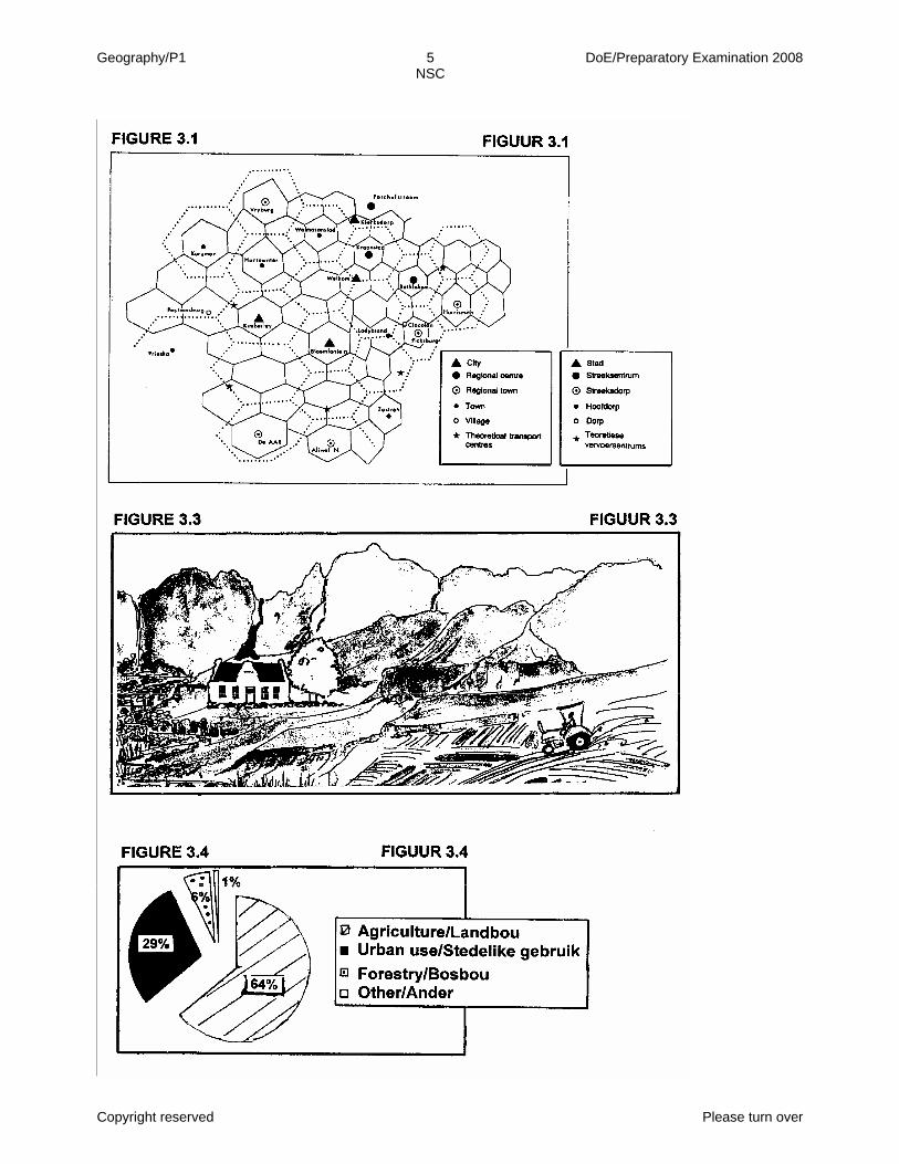
3.1 Refer to FIGURE 3.1 illustrating the application of the central place theory for a
section of South Africa. Indicate whether the following statements are TRUE or FALSE. Choose the answer and write only 'true' or 'false' next to the question number (3.1.1 – 3.1.5) in the ANSWER BOOK, for example 3.1.6 False.
3.1.1 A central place is the commercial zone in the centre of the city that
serves the people in the surrounding residential areas. 3.1.2 FIGURE 3.1 shows real urban hierarchies in South Africa.
3.1.3 Bloemfontein occupies a higher rank order than Kroonstad.
3.1.4 Kroonstad will have fewer high-order services than Wolmaransstad.
3.1.5 Kimberley has a larger sphere of influence than Hartswater. (5x2)(10)
3.2 The definitions in COLUMN A all refer to economic activities. The correct
terms used to describe each of these definitions is given in COLUMN B. Choose a term from COLUMN B that matches a definition in COLUMN A. Write only the Roman numerals (i – vii) next to the question number
(3.2.1 – 3.2.5) in the ANSWER BOOK, for example 3.2.6 (viii).
COLUMN A COLUMN B
3.2.1 3.2.2 3.2.3 3.2.4 3.2.5
The value of goods and services produced in a country in one year The payment obligations that arise when a country imports or exports goods A statement of account showing transactions with the rest of the world, over one year Activities that involve the exploitation of raw materials from the environment Activities that involve high-level scientific research
(i) (ii) (iii) (iv) (v) (vi) (vii)
balance of trade quaternary gross domestic product tertiary primary balance of payment gross national product
(5x2)(10)

Geography/P1 11 DoE/Preparatory Examination 2008 NSC
Copyright reserved Please turn over
3.3 Agriculture is the practice of growing crops and raising livestock (farm animals).
South Africa's agricultural sector is dominated by a large, almost exclusively white-owned-and-controlled commercial sector. Other farmers have few resources, especially land. The land that is available to them is generally of poor soil quality and has steep gradients. Refer to FIGURE 3.3.
3.3.1 Identify the rural settlement type shown in this figure. (1x2)(2)
3.3.2 Give reasons for your answer to QUESTION 3.3.1. (2x2)(4)
3.3.3 Which TWO possible factors influenced the choice of site of this
settlement? (2x2)(4) 3.3.4 Would you classify this farming as subsistence or commercial
farming? (1x2)(2) 3.3.5 Give a reason for your answer to QUESTION 3.3.4. (1x2)(2)
3.3.6 Name any TWO environmental problems the farmer might
experience. (2x2)(4) 3.3.7 Explain TWO measures being implemented by the South African
government to address the dual economy (commercial farming and subsistence farming) that exists in the agricultural sector. (2x2)(4)
3.4 Water is a critical resource in South Africa and much of the success of this
farmer (FIGURE 3.3) is dependent on the supply of water. Refer to FIGURE 3.4 showing the use of water by different economic sectors in South Africa.
3.4.1 Which economic sector uses the most water in South Africa? (1x2)(2)
3.4.2 Explain why this sector uses the most water. (1x2)(2)
3.4.3 Name THREE ways in which South Africa's scarce water supply can
be preserved. (3x2)(6) 3.4.4 Briefly explain why it is important to preserve South Africa's water
supply. (3x2)(6)
Geography/P1 12 DoE/Preparatory Examination 2008 NSC
Copyright reserved Please turn over
3.5 At the Earth Summit held in Rio de Janeiro (1992), 179 countries, including
South Africa, agreed to a programme of action called Agenda 21. This agreement emphasises development and poverty alleviation together with environmental issues. It aims to improve the living and working environments of all people, in particular the rural and urban poor.
3.5.1 Development in rural areas must be sustainable. Define the term
sustainable development. (1x2)(2) 3.5.2 Despite programmes of action like Agenda 21, people are still moving
away from rural areas to urban areas. (a) Explain the term rural depopulation. (1x2)(2)
(b) Name any TWO push factors encouraging people to move from
rural areas. (2x2)(4) 3.5.3 Agenda 21 encourages programmes that are planned, managed and
organised by the people in a local area. Why is the success of this programme dependent on the participation of local people? (1x2)(2)
3.5.4 Agenda 21 includes access to basic education for all individuals.
Suggest THREE measures that may be implemented in a poorly developed rural area to raise the level of literacy. (3x2)(6)
3.6 Women account for 75% of the labour force and produce 90% of household food in rural areas. When they are weakened by HIV/Aids they are less able to produce their own food.
3.6.1 Why are women in rural areas so vulnerable to HIV/Aids? (2x2)(4)
3.6.2 Most of these women's husbands are working in mines or urban
centres in Southern Africa as migrant labourers. (a) When is someone considered a migrant labourer? (1x2)(2)
(b) Explain why the migrant labour system plays a major role in the
spread of HIV/Aids in Southern Africa. (2x2)(4)
Geography/P1 13 DoE/Preparatory Examination 2008 NSC
Copyright reserved Please turn over
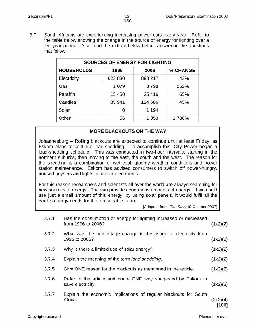
3.7 South Africans are experiencing increasing power cuts every year. Refer to
the table below showing the change in the source of energy for lighting over a ten-year period. Also read the extract below before answering the questions that follow.
SOURCES OF ENERGY FOR LIGHTING HOUSEHOLDS 1996 2006 % CHANGE Electricity 623 830 893 217 43%
Gas 1 079 3 798 252%
Paraffin 15 450 25 416 65%
Candles 85 941 124 686 45%
Solar 0 1 194
Other 56 1 053 1 780%
MORE BLACKOUTS ON THE WAY!
Johannesburg – Rolling blackouts are expected to continue until at least Friday, as Eskom plans to continue load-shedding. To accomplish this, City Power began a load-shedding schedule. This was conducted in two-hour intervals, starting in the northern suburbs, then moving to the east, the south and the west. The reason for the shedding is a combination of wet coal, gloomy weather conditions and power station maintenance. Eskom has advised consumers to switch off power-hungry, unused geysers and lights in unoccupied rooms. For this reason researchers and scientists all over the world are always searching for new sources of energy. The sun provides enormous amounts of energy. If we could use just a small amount of this energy, by using solar panels, it would fulfil all the earth’s energy needs for the foreseeable future.
[Adapted from: The Star, 10 October 2007]
3.7.1 Has the consumption of energy for lighting increased or decreased from 1996 to 2006? (1x2)(2)
3.7.2 What was the percentage change in the usage of electricity from
1996 to 2006? (1x2)(2) 3.7.3 Why is there a limited use of solar energy? (1x2)(2)
3.7.4 Explain the meaning of the term load shedding. (1x2)(2)
3.7.5 Give ONE reason for the blackouts as mentioned in the article. (1x2)(2)
3.7.6 Refer to the article and quote ONE way suggested by Eskom to
save electricity. (1x2)(2) 3.7.7 Explain the economic implications of regular blackouts for South
Africa. (2x2)(4) [100]
Geography/P1 14 DoE/Preparatory Examination 2008 NSC
Copyright reserved Please turn over
QUESTION 4
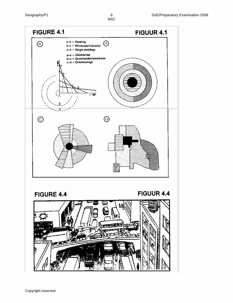
4.1 Refer to FIGURE 4.1 showing models of urban land use. Read the paragraph
below. Choose the correct word(s) from those given in brackets to make ALL the statements TRUE. Write only the word(s) next to the question number (4.1.1. – 4.1.5) in the ANSWER BOOK, for example
4.1.6 Medium. Diagram B represents the (4.1.1) [concentric zone/sector] model. In the
(4.1.2) [concentric zone/multiple nuclei] model, the land use zones display a cellular pattern. Urban land use model B was developed by (4.1.3) [Hoyt/Burgess]. According to diagram A, the highest land values are in zone (4.1.4) [1/3].
In diagram A, zone 2 is associated with (4.1.5) [heavy/light] industries. (5x2)(10) 4.2 Read the paragraph below. Choose the correct word(s)/phrase from those
given in brackets to make ALL the statements TRUE. Write only the word(s)/phrase next to the question number (4.2.1 – 4.2.5) in the ANSWER BOOK, for example. 4.2.7 Tertiary.
The mining industry is a (4.2.1) [primary/secondary] activity that plays a major
role in South Africa's economic development. The lack of (4.2.2) [water/global markets] hampers mining activities in South Africa. The gold mines in Gauteng receive their electricity from (4.2.3) [thermal power stations in Mpumalanga/a nuclear power station in the Western Cape]. Once gold has been processed, the value of the raw material (4.2.4) [decreases/increases]. This will have a (4.2.5) [negative/positive] effect on South Africa's balance of trade. (5x2)(10)
4.3 At present approximately 59% of all South Africans are living in cities. However, the rate of urbanisation is still increasing.
4.3.1 Explain the following terms:
(a) Urbanisation (1x2)(2)
(b) Rate of urbanisation (1x2)(2)
4.3.2 Give TWO reasons why South Africa's rate of urbanisation is
increasing by referring to pull factors. (2x2)(4) 4.3.3 Name TWO disadvantages of urbanisation for South Africa's rural
community. (2x2)(4) 4.3.4 Name and explain ONE measure the local government in rural areas
could put in place to slow down the rate of urbanisation. (2x2)(4)

Geography/P1 15 DoE/Preparatory Examination 2008 NSC
Copyright reserved Please turn over
4.4 As a city's population increases, the demand for transport (both public and
private) increases. Traffic congestion increases as this demand is met. Refer to FIGURE 4.4 showing a traffic jam in an urban settlement.
4.4.1 What is a traffic jam? (1x2)(2)
4.4.2 Give TWO possible reasons for traffic congestion in the CBD. (2x2)(4)
4.4.3 Traffic congestion threatens the sustainability of cities. Explain this
statement. (2x2)(4) 4.4.4 Give TWO possible solutions to solve the problem of traffic
congestion in the CBD of a large urban settlement. (2x2)(4) 4.4.5 Apart from traffic congestion, name TWO other factors that threaten
the sustainability of cities. (2x2)(4) 4.4.6 Give TWO reasons why it is important to maintain cities as
sustainable units. (2x2)(4) 4.4.7 Explain any TWO measures that town planners must adopt when
planning cities of the future. (2x2)(4)
Geography/P1 16 DoE/Preparatory Examination 2008 NSC
Copyright reserved Please turn over
4.5 The Eastern Cape has the lowest per capita income in South Africa with a
population of over 7 million people. Urban areas like the Nelson Mandela Metropolitan area houses most of the economic activities, like the Coega IDZ project. Refer to the extract below and answer the questions that follow.
IDZ PRODUCTS UNLIKELY TO HIT LOCAL MARKETS
The Eastern Cape experienced the greatest level of poverty in South Africa in 1998. Of the three regions that make up the present Eastern Cape, the former Transkei was by far in the worst position. In 2006 the government introduced a new economic strategy, Accelerated and Shared Growth Initiative for South Africa (ASGISA), to halve poverty and unemployment in South Africa. As part of their economic development strategy in the Eastern Cape, the government introduced the Coega Industrial Development Zone (IDZ) – an 11 000 hectare green fields, duty-free manufacturing and logistics park situated 20 km outside of Port Elizabeth. It was reported by a senior government official that goods manufactured in this IDZ were unlikely to find their way into the South African market. These IDZs are export-processing areas that are designed to accelerate economic growth by boosting South Africa's export market and attracting foreign direct investment, which enjoys the advantages of tax and tariff concessions. The four IDZs are Coega, East London, Johannesburg and Richards Bay and these areas will be used as gateways to global markets. They are situated at break-of-bulk locations to allow easy transportation of finished goods to parts of the world where there is a demand. The businesses and industry operating in IDZs would not be charged import duties on raw materials sourced overseas. They would also be exempt from paying VAT on supplies obtained locally.
4.5.1 Define the term globalisation. (1x2)(2)
4.5.2 Explain why the Coega development is classified as a break-of-bulk
point. (2x2)(4) 4.5.3 Briefly explain TWO advantages to a company relocating to an IDZ
such as Coega. (2x2)(4) 4.5.4 One of the companies relocating in the Coega area is manufacturing
goods from wood – a renewable resource. Explain what a renewable resource is. (1x2)(2)
4.5.5 Suggest TWO measures that may be adopted to ensure the
sustainable exploitation (use) of wood. (2x2)(4) 4.5.6 Goods manufactured at the Coega IDZ will not benefit the local
communities in the Eastern Cape. Explain why this is the case. (2x2)(4) 4.5.7 Explain why it is important to include the local communities in the
development of the Coega IDZ. (2x2)(4) 4.5.8 The provision of free housing, education and health services are
being implemented by the government to improve the standard of living of rural communities. Name TWO problems that may arise from this practice. (2x2)(4)
Geography/P1 17 DoE/Preparatory Examination 2008 NSC
Copyright reserved
4.6 Economic activities can be considered as being formal or informal. In
developing countries the informal sector is a major employer of people. 4.6.1 What is the informal sector? (1x2)(2)
4.6.2 People guarding your car at a shopping centre can be
classified as an example of an informal sector activity. (a) Name ONE disadvantage for people doing this type of
work. (1x2)(2) (b) Give ONE reason for people being involved in informal
employment. (1x2)(2) (c) Explain why the involvement of many people in the
informal sector impacts negatively on a country's economy. (2x2)(4)
[100]
GRAND TOTAL: 300
Geography/P1 1 DoE/Preparatory Examination 2008 NSC
Copyright reserved Please turn over
48° 54° 80° 66° 72° 78°
48° 54° 80° 66° 72° 78°
-18° -24°
FIGURE 1.1 FIGUUR 1.1
-18° -24° -30°
Geography/P1 2 DoE/Preparatory Examination 2008 NSC
Copyright reserved Please turn over
60 dead, 600 homeless 80 cars lost
Arch of bridge far too narrow
River channel made narrow due to buildings
Bridge trapped boulders and trees causing temporary dams which later broke causing a wave 12 m high to travel downstream at 30 km/h
December relatively wet so ground already reached saturation level
Small catchment area, rainfall soon collects in the river
Heavy intensive rainfall Manzi had 250 mm in 12 hours
No recording of early warning system in the Manzi River drainage basin
ENGLISH DIAGRAM FIGURE 1.5
MANZI RIVER DRAINAGE BASIN
Rapid
Manzi River
Narrow steepsided valleys
URBAN SETTLE- MENT
Waterfall

Geography/P1 3 DoE/Preparatory Examination 2008 NSC
Copyright reserved Please turn over
FIGURE 2.1 FIGUUR 2.1
1 012 mb 1 008 1 004 1 000
04:
00
0
6:00
08:
00
1
0:00
Geography/P1 4 DoE/Preparatory Examination 2008 NSC
Copyright reserved Please turn over
Trees lean over Bome staan skuins
Tree roots grow up the slope Boomwortels groei teen die helling op
Soil piles up at foot of slope Grond versamel teen die hellingvoet
Soil moves slowly down the slope Grond beweeg stadig teen die helling af
Terraces form Terrasse vorm
Poles lean over Pale staan skuins
Retaining walls crack Keerwalle breek
FIGURE 2.4 FIGUUR 2.4
FIGURE 2.7 FIGUUR 2.7
FIGURE 2.6 FIGUUR 2.6
FIGURE 2.8 FIGUUR 2.8
DayDag
NightNag
Geography/P1 5 DoE/Preparatory Examination 2008 NSC
Copyright reserved Please turn over
Geography/P1 6 DoE/Preparatory Examination 2008 NSC
Copyright reserved