National Military Sensing · PDF fileNational Military Sensing Symposium ... Mr. George...
16
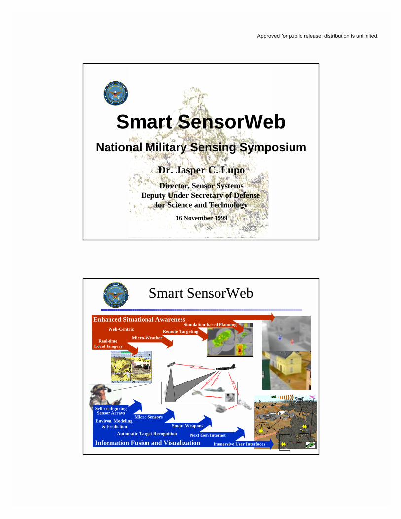
Dr. Jasper C. Lupo Director, Sensor Systems Deputy Under Secretary of Defense for Science and Technology 16 November 1999 Smart SensorWeb National Military Sensing Symposium Smart SensorWeb UAV Enhanced Situational Awareness Web-Centric Real-time Local Imagery Micro-Weather Remote Targeting Simulation-based Planning Self-configuring Sensor Arrays Automatic Target Recognition Information Fusion and Visualization Micro Sensors Next Gen Internet Smart Weapons Environ. Modeling & Prediction Immersive User Interfaces Approved for public release; distribution is unlimited.
Transcript of National Military Sensing · PDF fileNational Military Sensing Symposium ... Mr. George...
Dr. Jasper C. LupoDirector, Sensor Systems
Deputy Under Secretary of Defense for Science and Technology
16 November 1999
Smart SensorWebNational Military Sensing Symposium
Smart SensorWeb
UAV
Enhanced Situational AwarenessWeb-Centric
Real-time Local Imagery
Micro-WeatherRemote Targeting
Simulation-based Planning
Self-configuringSensor Arrays
Automatic Target Recognition
Information Fusion and Visualization
Micro Sensors
Next Gen Internet
Smart WeaponsEnviron. Modeling
& Prediction
Immersive User Interfaces
Approved for public release; distribution is unlimited.

Form SF298 Citation Data
Report Date("DD MON YYYY") 16111999
Report TypeN/A
Dates Covered (from... to)("DD MON YYYY")
Title and Subtitle Smart SensorWeb National Military Sensing Symposium
Contract or Grant Number
Program Element Number
Authors Project Number
Task Number
Work Unit Number
Performing Organization Name(s) and Address(es) Deputy Under Secretary of Defense for Science and Technology
Performing Organization Number(s)
Sponsoring/Monitoring Agency Name(s) and Address(es) Monitoring Agency Acronym
Monitoring Agency Report Number(s)
Distribution/Availability Statement Approved for public release, distribution unlimited
Supplementary Notes
Abstract
Subject Terms
Document Classification unclassified
Classification of SF298 unclassified
Classification of Abstract unclassified
Limitation of Abstract unlimited
Number of Pages 15

Smart SensorWeb
“… emphasizes large arrays oflocal sensors joined with otherassets: imagery, weather,weapons, simulations, etc. . . .”
Vision: An intelligent, web-centric distribution and fusionof sensor information . . . that provides greatly enhancedsituational awareness, on demand, to Warfightersat lower echelons.
Unprecedented Advances inCommercial Technologies
• Mobile wireless networks• Micro computers• Tele-presence• Geo-location and tracking devices
• Wireless internet connectivity• Virtual reality (entertainment,video games, immersiveinteraction)

Relevant DoD S&T• DARPA
– Sensor Progams• VSAM• AVS• SensIT
– Knowledge-Base Programs• Dynamic Databases• Command Post of the Future• Warfighter Visualization• Intelligent Integration of Information
Technology• Rapid Knowledge Formation
– Comm Network Programs• Service Programs
– ACTDs: MOUT, ELB, JISR, FMP– Warrior Extended Battlespace Sensors– Multifunction RF Sensor Technology– Cooperative Engagement Capability– Battlespace Infosphere
• DUSD(S&T) Initiatives– Cognitive Readiness, ATR, etc.
• DMSO– HLA– Environmental & HB Reps
• Basic Research– MURI
• Data Fusion in Large Array Mirco-sensors
• Mobile Augmented BattlespaceVisualization
• Real-Time Fault-Tolerant NetworkProtocols
• Adaptive Mobile, Wireless Networksfor Highly Dynamic Environments
– Basic Research Plan efforts• Sensors, algorithms, environmental
and cognitive modeling, etc.
Clip
AudioAlarm(Optional)
Keypad
Force Medical Protection ACTD
Providing force protectionthrough superior
technology!
Phase I:Chemical Dosimeter(Non Real-time)
Phase II:Chemical Dosimeter (Real-time)/Biological Dosimeter(Non Real-time)
Estimated unit cost for production:Between $10-$100 per badge

Micro FLIR
Sensors…• Multi-domain sensors• Low cost and micro size• Capable of target ID (ATR)• Autonomous & platform based
The Evolution
SensorWeb…• Sensor arrays• Wireless, high-bandwidth communications• Next Generation Internet• Efficient links to weapons and simulations
Smart SensorWeb…• Adaptive, intelligent sensor arrays• Intelligent information management and dissemination-- Avoids “information overload”
• Dynamic databases and knowledge-bases• Intelligent agents as mediators• Multi-sensory, natural user interfaces
Smart SensorWeb:Objectives (FY00 - FY02)
- Identify Warfighter requirements for SSW
- Showcase/illuminate current S&T products and capabilities
- Demonstrate SSW technical feasibility
- Demonstrate enhanced situational awareness
- Assess utility to the Warfighter
- Identify future research priorities

SSW Elements• ImageWeb
– Adaptive sensor arrays– Intelligent data fusion
SituationalAwareness
IMAGE
• WeaponsWeb– Sensor-shooter links– Optimized engagements
WEAPONS
WEATHER
Clear
Fog
Clouds&
Rain
• WeatherWeb– Nowcasts & predictions– Dynamic weather effects
SIMULATION
• SimulationWeb– Simulation-based development– Mission planning, rehearsal, & training
No where to hide!• Information Integration
– Info fusion & visualization– Data standards
Enhanced
SSW Concept
• ImageWeb
DecisionDominance
- ID Sensor Arrays- Add Sensor Arrays

SSW Concept
• ImageWeb
DecisionDominance
- ID sensor arrays- Add sensor arrays- Sensor alerts- Visualize data- Obtain images
SSW Concept
• ImageWeb
• WeaponsWeb
DecisionDominance
- ID sensor arrays- Add sensor arrays- Sensor alerts- Visualize data- Obtain images
- Determine threat- Friendly situation- Engage target- Assess damage
“Fire Mission.Enemy Tank in
Town.”

H
L
Fog0400-0530
Sandstorm1500-1800
SSW Concept
• ImageWeb
• WeaponsWeb
• WeatherWeb
DecisionDominance
- ID sensor arrays- Add sensor arrays- Sensor alerts- Visualize data- Obtain images
- Determine threat- Friendly situation- Engage target- Assess damage
- Nowcasts &predictions- Dynamic effects
SSW Concept
• ImageWeb
• WeaponsWeb
• WeatherWeb
• SimulationWeb
DecisionDominance
- ID sensor arrays- Add sensor arrays- Sensor alerts- Visualize data- Obtain images
- Determine threat- Friendly situation- Engage target- Assess damage
- Nowcasts & pred.- Dynamic effects
- Fly-through- Planning/rehearsal

✰ Testbeds allow a near-term technology “build-and-demonstrate” that evolves to the long-term vision
✰ Four Key Testbed Projects to DemonstrateCapability:◆ ImageWeb◆ WeatherWeb◆ WeaponsWeb◆ SimulationWeb
Smart SensorWeb:Testbed Approach
RouterDatabase
Processor
Cellular Comm Links
Long Haul Comms NodeUnattended
RouterDatabase
Processor
Long Haul Comms NodeMobile
Command Post
UAV
UGS
RouterProcessor
“One Ring to rule them all,One Ring to find them,
One Ring to bring them all, andin the darkness bind them.”
JRR Tolkien, “Lord of the Rings”
Dat
a ledge
Unders
Information
Know
tanding
Information Integration Decision Dominance
Focus on MOUT ScenarioCenter for Army Lessons Learned
– Majority of MOUT casualties due to inadequate situational awareness– Commanders have difficulty “seeing” the fight
Changing Environments
Conflict Increasing
Proliferation of Military andCommercial Technologies
Operations in UrbanEnvironments
Preponderance of Coalitions
Ethnic Strife
Rogue NationStates/Alliances
International CrimeOrganizations
Transnational Actors/Terrorists
Weapons ofMass Destruction
Greater Range ofSolutions
No US Monopoly inall Technologies
Complex Targets/Terrain
InformationManagement Crit ical
SecurityThreats 21st Century Impact

ImageWeb: Dr. Don Reago, Army NVESD Ms. Mun-Won Fenton, ONRWeatherWeb: Dr. Douglas Brown, ARL Dr. John McCarthy, NRL, MontereyWeaponsWeb: Col Norman Leonpacher, AFRL-Eglin AFB Dr. James Chew, ONRSimulationWeb: Mr. William Jarvis, US Army NVESD CAPT Robert Eberth, MCWLInformation Integration: Mr. John Graniero, AFRL Mr. George Lukes, DARPA Dr. Lee Hammarstrom, NRO
Smart SensorWeb:Key Players
Smart SensorWeb: Dr. Jasper Lupo, DUSD(S&T)/SS Dr. Charles Holland, DUSD(S&T)/IS LTC Bruce Gwilliam, DUSD(S&T)/SS Mr. Jeff Paul, DUSD(S&T)/SS Mr. Marshall Potter, DUSD(S&T)/ISCAPT David Martin, DUSD(S&T)/IS
ImageWebYear 1 - Web on Line
Point, click and see in an urban environment:• Priority alert to operator• 3-D visualization• Multiple sensors
•IR/EO,•acoustic, &•seismic•µµµµ-sensors
• Internet/LAN real-time access• Images registered to site map (Compact Terrain Data Base)• Target classification• Target geolocation• Target tracking• Target hand-off
Alerting icon queriedfor imagery

Year 2 - ImageWeb Assistant
Building on Year 1 to automate target ofinterest detection/recognition and tracking• Data fusion between multiple viewpoints• Multi-modal data fusion (thermal /daylight)• Random sensor placement experiments• Weather Web integration• Image to model registration• MTI/Change Detection/Cross-cueing• Sensor arbitration for ‘best view’• Geolocation via N-camera registration• Simulation integration via HLA protocol
Multi-modal Data Fusion Image to model registration
Smart Sensor Webs• Mobile Ad Hoc Network• Air dropped sensors• Tactical mobile robots• Multi-sensor coordination• Leveraging DARPA’s SUO, IU, DDB, MEMS Programs• Novel sensors• Managed video/data streams• Tactical sensor integration• 4-D model - live simulation
Year 3 - Intelligent Image Agent
Router
Database
Processor
Cellular Comm Links
Long Haul Comms NodeUnattended
Router
Database
Processor
Long Haul Comms NodeMobile
Command Post
UAV
UGS
RouterProcessor

WeatherWeb
Sensor Models
Terrain
PropagationModeling Configuration
CommunicationsProcessing
Simulation Uses– System design– Experiment planning– Deployment planning– ConOps development– Training
Simulated sensor dataCommunications performanceSensor energy expenditure
User Display
Compare
WeatherSimulation
Sensor WebSimulation
ForecastAlgorithm
Pre-mission Planning
Target Simulation
Weapons Fly-out Simulation
RPV Weapon EmulationInter-Weapon LAN Simulation
Web portal
Web portal
Weather
Imagery
Pre-mission Planning
Target Simulation
Weapons Fly-out Simulation
RPV Weapon EmulationInter-Weapon LAN Simulation
Web portal
Web portal
Weather
Imagery
WeaponsWeb
Smart SensorWeb

LADAR Automatic TargetRecognition Captive Flight Test Results
SimulationWeb
ImageWeb
VirtualTOC Model
Sensor Network Model
LiveSensors(WEBS)
UGV/UAV
CVs
Live Sensors
Virtual Sensors
ImageGenerator
SensorModels
Communication Model
Micro DDB
ASAS
DDB
Theater LevelVirtual
Micro (Tactical) LevelLive/Virtual
World ModelScenarios, Ground Truth, GIS Data, Maps,
Site Models, Reference Imagery
C2/SA Interface to Warfighter
Theater Sensors
Tactical Sensor Network

SSW:From Data to Understanding
Information
Data
Knowledge
Under-standing
An image of a section of a map
There is a tank in the image
Enhanced visualization ofthe battlefield:• 3D view of the area• Tank is one of three in a column• Friendly locations
Column of enemy tanks is reconnaissance element of larger tank regiment• Hills provide the enemy cover fromfriendly direct fire for next 20 minutes• Indirect fire engagement now can haltregiment’s narrow route of advance untilattack air arrives
Managing SSW InformationApproaches for Handling Information
Specific Information Management(registered to discreet objects,
locations, & events) This patch of ground is swampy. These four vehicles are tanks. This building is a military HQ. Click forfloor plan.
Generalized Information Management(associated with classes of objects,
locations, & events) Low lying ground tends to be swampy. Tanks move in platoons of four. Military buildings are located at the edge of thetown and the headquarters building is the largestin the group.

FY00 FY01 FY02
InformationIntegration
SimulationWeb
ImageWeb
WeaponsWeb
WeatherWeb
SSW Testbed Plan
•Broad initiative– Large arrays of local sensors
– Testbed emphasis to prove concept
•Leverages DoD and commercialinvestments
•Long term research opportunities
Summary
“seeding” the battlefieldwith a network of
distributed sensors
Operational DecisionDominance