Nonpersonal Communications: Advertising, PR & Sales Promotion Dr. John Gaskins.
Upload
cybera-incCategory
view
3.659download
1


[-]
Application Template
NASA World Wind JavaDemo Applications andAppletsLast modified March 5, 2010
This page gives you access to a number of World Wind Java example applications orapplets, and user applications of the SDK.
World Wind Java Example Applications
Application Template
This is the most basic usage of the SDK. Itshows the default globe with the default layer listand panel.
It features the Earth with SRTM Plus elevationand bathymetry, the Blue Marble NextGeneration may 2004, I Cubed Lansat 15m, andUnited States Department of Agriculture NAIPimagery layers among others. It also displays thestars background, atmospheric effect, compass,world map and scalebar that are common tomost of the example applications.
> ApplicationTemplate.jnlp - launch with Java Web Start.
> WWJDemo.jnlp - features an array of World Wind capabilities: surface graticules,terrain profiling, on screen view controls, and real time manipulation of terrain verticalexaggeration.
WMS Layer Manager
NASA World Wind Java Demo Applications and Applets http://worldwind.arc.nasa.gov/java/demos/
1 of 16 9/22/10 5:42 PM

WMS Layer Manager
SectorSelectAndSave
Scankort Denmark Data
This example application demonstrates the SDKWMS capabilities. It features a WMS layer panelthat allows you to access any WMS server andlayers.
To add a server, click on the "+" tab and enter theserver url. After the WMS discovery process, thelist of available layers will be displayed. Selectone to add it to the current globe layer list.Unselect it to remove it.
> WMSLayerManager.jnlp - launch with Java Web Start.
Exporting Surface Imagery and Elevations
Demonstrates how to use the SectorSelectorutility to save a selected region of surfaceimagery and elevations to a GeoTIFF file.
> SectorSelectAndSave.jnlp - launch with JavaWeb Start.
Scankort Denmark Data
Demonstrates high resolution imagery (0.2meters per pixel) and elevation data (1.6 metersper pixel) served by the World Wind WMS, andvisualized by the World Wind Java client.
> ScankortDenmark.jnlp - launch with Java WebStart.
Analytic Surface
NASA World Wind Java Demo Applications and Applets http://worldwind.arc.nasa.gov/java/demos/
2 of 16 9/22/10 5:42 PM

Analytic Surface
Terrain Profiler
Annotations
Demonstrates visual representation of scalarvalues over a grid of geographic positions.AnalyticSurface supports dynamic scalar data byproviding a simple, high throughput renderingpipeline for the application.
This demonstrates two unique surface types:
A dynamic surface representing randomaltitudes over the Coast of Florida, USA.A static surface representing annualprecipitation in Washington State, USA.
> AnalyticSurface.jnlp - launch with Java Web Start.
Terrain Profiler
This application shows the terrain profile layer inaction with its various controls. It allows you toview a realtime section profile graph for anyplace on the planet, at any scale - continent,country or mountain range... just by moving themouse.
It proves particulary useful to explore the oceanfloors where the bathymetry data revealsimportant geologic features.
> TerrainProfiler.jnlp - launch with Java Web Start.
Annotations
This example allows you to experiment with themultiple options of World Wind Java annotationfeature.
Annotations are text labels with support formultiline text, simple HTML and many stylingattributes such as font face, size and colors,bubble shapes and background image.
> Annotations.jnlp - launch with Java Web Start.
NASA World Wind Java Demo Applications and Applets http://worldwind.arc.nasa.gov/java/demos/
3 of 16 9/22/10 5:42 PM

Latest earthquakeson Mercator Flat World
Line Builder
Runtime Statistics
Flat World Earthquakes
This example shows the latest earthquakes overa flat world projection. It allows you to see thewhole globe at once while retaining the capabilityto zoom onto the surface and still experience 3Dterrain.
> FlatWorldEarthquakes.jnlp - launch with JavaWeb Start.
Line Builder
This simple example allows you to interactivelydraw a path over the terrain surface.
It demonstrates how an application can use andconsume mouse events before they get to thedefault view input handler.
> LineBuilder.jnlp - launch with Java Web Start.
Runtime Statistics
This example shows the runtime statistics panelthat displays important information about theSDK memory usage and response time.
> RuntimeStatistics.jnlp - launch with Java WebStart.
Dragging Shapes
NASA World Wind Java Demo Applications and Applets http://worldwind.arc.nasa.gov/java/demos/
4 of 16 9/22/10 5:42 PM

Dragging Shapes
Surface Objects
Anaglyph Stereo
This example shows how you can select anddrag surface shapes and icons in World WindJava.
> DraggingShapes.jnlp - launch with Java WebStart.
Surface Objects
Demonstrates visualization of terrain followingsurface objects such as text, icons, annotationshadows, and custom dynamic objects.
> SurfaceObjects.jnlp - launch with Java WebStart.
Anaglyph Stereo
This is essentialy the above application templatebut with anaglyph stereo viewing capability. Itallows you to explore the world in 'real' 3D usingred and cyan glasses with the red filter over theleft eye.
To get a confortable experience use the slider toadjust the interocular distance.
> AnaglyphStereo.jnlp - launch with Java WebStart.
The Moon
NASA World Wind Java Demo Applications and Applets http://worldwind.arc.nasa.gov/java/demos/
5 of 16 9/22/10 5:42 PM

Moon
Blue Marble Twelve Month
World Wind Web Service Catalogs
World Wind can display any globe if providedwith the data. Here is the Moon with the full layersets available from NASA's servers.
> Moon.jnlp - launch with Java Web Start.
Blue Marble Twelve Month
This example application gives you access to thetwelve month of the Blue Marble Next Generationdataset for the year 2004.
It also lets you play an animation of the fulltwelve month cycle, showing how the Earth facechanges over the year, as seen from space.
> BMNGTwelveMonth.jnlp - launch with JavaWeb Start.
World Wind Web Service Catalogs
The World Wind Web Service Catalogsapplication provides easy access to geospatialimagery via web service catalogs. NASA's EarthScience Gateway catalog, and the NavalResearch Laboratory's Geospatial InformationDatabase (GIDB) Portal System are included asexamples.
This application utilizes OGC Catalog Servicesupport built into World Wind Java.
> WorldWindCatalogs.jnlp - launch with Java Web Start.
Multimedia Annotations
NASA World Wind Java Demo Applications and Applets http://worldwind.arc.nasa.gov/java/demos/
6 of 16 9/22/10 5:42 PM

Multimedia Annotations
On Screen Controls
Airspaces
Demonstrates the use of World Wind annotationsto communicate images and sound.
> MultimediaAnnotations.jnlp - launch with JavaWeb Start.
On Screen Controls
Demonstrates the use of World Wind annotationsto create simple user interfaces embedded intothe World Window.
> AnnotationControls.jnlp - launch with Java WebStart.
Airspaces
Demonstrates the World Wind Java controlledairspaces tookit.
Airspaces feature 3D volumes controlled bygeographic coordinates and upper- and lower-altitude boundaries. Airspaces optionally conformto the terrain as you move them. Theydemonstrate what's possible in terms of dynamicmanipulation of data in 3D space.
> Airspaces.jnlp - launch with Java Web Start.
Airspace Builder
NASA World Wind Java Demo Applications and Applets http://worldwind.arc.nasa.gov/java/demos/
7 of 16 9/22/10 5:42 PM

AirspaceBuilder
[-]
Demonstrates runtime construction of 3D shapesusing the World Wind Java controlled airspacestookit
> AirspaceBuilder.jnlp - launch with Java WebStart.
Controls
Create a new shape:Press the "New shape" button.If the option "Auto fill new shapes" is checked, a defaultshape will be created for you.
Select a shape: Left mouse button click
Delete a shape: Select the shape, then press the delete key.
Move a shape or move acontrol point: Drag the shape or control point with the left mouse button
Resize a shape: Hold the Shift key and drag any control point with the leftmouse button
Create a control point: Hold the Alt key and click the left mouse button
Delete a control point: Hold the Ctrl key and click the left mouse button
World Wind Java Applets Examples
Cascade Volcanoes Tour Applet
NASA World Wind Java Demo Applications and Applets http://worldwind.arc.nasa.gov/java/demos/
8 of 16 9/22/10 5:42 PM

Cascade Volcanoes Tour Applet
Javascript Location-marks Applet
[-]
This page shows a World Wind applet controlledfrom HTML hyperlinks in the page body text.
In this example all the specific elements - textlabels and view positions, are controlled from theHTML and Javascript code within the page. Thesame java applet could be used for many otherpurposes without any change.
> Cascade Volcanoes Tour Applet page...
See also:> The 'full page' applet...
Javascript Location-marks Applet
This page allows you to save the view currentlocation into a list of favorite places.
When double clicking on a location in the list, theview is sent flying to the position and angle it hadwhen you saved that location. The list is savedinto a permanent cookie on the local computerand will be retreived the next time you comeback.
> Javascript Location-marks Applet page...
User Applications
GLIDER - Globally Leveraged integrated data explorer for research
GLIDER (Globally Leveraged Integrated DataExplorer for Research) is a NASA ACESS fundedproject. The goal of this project is to integratethree existing applications, namely World Wind,Interactive Visualizer and Image Classifier(IVICS) and the Algorithm Development andMining (ADaM) toolkit into a single seamless toolfor research and education community. GLIDERwill be a complete comprehensive, easy to use
NASA World Wind Java Demo Applications and Applets http://worldwind.arc.nasa.gov/java/demos/
9 of 16 9/22/10 5:42 PM

GLIDER
GeoWind
EOLi-sa
tool for thematic information extraction fromNASA imagery.
> GLIDER home page by UAHuntsville ITSC
GeoWind
GeoWind is an open source GIS platform thatintegrates OGC as implemented in GeoToolswithin NASA's WorldWind.
The vision of this effort is the creation of an opengeospatial system that enables the scientificmodeling process to be closer to a 'real world'experience.
> GeoWind home page
EOLi (Earth Observation Link) by ESA (European Space Agency)
EOLi (Earth Observation Link) is the EuropeanSpace Agency's client for Earth ObservationCatalogue and Ordering Services.
Using EOLi, you can browse the metadata andpreview images of Earth Observation dataacquired by the satellites ENVISAT, ERS,Landsat, IKONOS, DMC, ALOS, SPOT,Kompsat, Proba, JERS, IRS, Nimbus, NOAA,SCISAT, SeaStar, Terra/Aqua.
By default, EOLi-sa uses a 2d drawing mode. To enable World Wind, click on thelayered map icon in the upper right for map settings. Then choose Orthographic or PlateCarrée (new 3D map) for a projection.
> ESA EOLi home page by ESA/ESRIN, Italy
Gaea+
NASA World Wind Java Demo Applications and Applets http://worldwind.arc.nasa.gov/java/demos/
10 of 16 9/22/10 5:42 PM
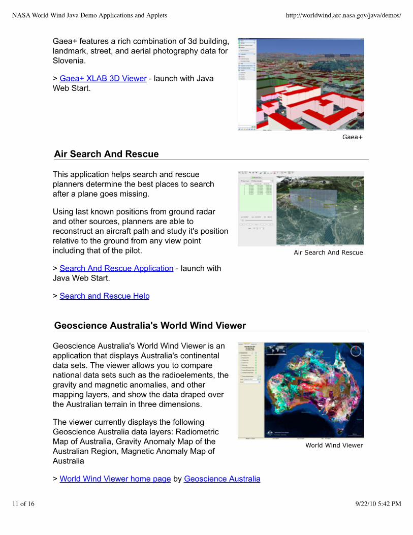
Gaea+
Air Search And Rescue
World Wind Viewer
Gaea+ features a rich combination of 3d building,landmark, street, and aerial photography data forSlovenia.
> Gaea+ XLAB 3D Viewer - launch with JavaWeb Start.
Air Search And Rescue
This application helps search and rescueplanners determine the best places to searchafter a plane goes missing.
Using last known positions from ground radarand other sources, planners are able toreconstruct an aircraft path and study it's positionrelative to the ground from any view pointincluding that of the pilot.
> Search And Rescue Application - launch withJava Web Start.
> Search and Rescue Help
Geoscience Australia's World Wind Viewer
Geoscience Australia's World Wind Viewer is anapplication that displays Australia's continentaldata sets. The viewer allows you to comparenational data sets such as the radioelements, thegravity and magnetic anomalies, and othermapping layers, and show the data draped overthe Australian terrain in three dimensions.
The viewer currently displays the followingGeoscience Australia data layers: RadiometricMap of Australia, Gravity Anomaly Map of theAustralian Region, Magnetic Anomaly Map ofAustralia
> World Wind Viewer home page by Geoscience Australia
NASA World Wind Java Demo Applications and Applets http://worldwind.arc.nasa.gov/java/demos/
11 of 16 9/22/10 5:42 PM

World Wind Geo
blueMarine
World Wind Geo
"World Wind Geo is an experimental geo browserbuilt on top of two of the best open sourcetechnologies: the World Wind Java SDK andEclipse."
"The new version of our 3D globe is closing thegap between GIS & SIS (Scientific InformationSystems) by incorporating low/med/hi resolutionGIS datasets from multiple sources: NASA, MSVirtual Earth, and others plus the great javaNetCDF library for plotting/subsetting capabilitiesof scientific data."
> World Wind Geo home page by Vladimir Silva.
blueMarine
BlueMarine is an open source application for thedigital photo workflow. It uses World Wind todisplay the positions of georeferenced imagesover a 3D map.
"The blueMarine project will provide you anall-in-one tool for managing your photos, from theshoot up to the archiving and beyond."
> blueMarine home page by Fabrizio Giudici.
JSatTrack
NASA World Wind Java Demo Applications and Applets http://worldwind.arc.nasa.gov/java/demos/
12 of 16 9/22/10 5:42 PM

JSatTrack
GeoMapApp
"JSatTrak is a Satellite tracking program writtenin Java. It allows you to predict the position ofany satellite in real time or in the past or future. Ituses advanced SGP4/SDP4 algorithmsdeveloped by NASA/NORAD to propagate thesatellite orbits."
"The program also allows for easy updating ofcurrent satellite tracking data via CelesTrak.com.Because this application was written in Java, itshould run on almost any operating system ordirectly off the web using java web start!"
"Version 3.0 requires Java 1.6 - and usesNASA's World Wind Java SDK (included) andJOGL for 3D rendering (included for win)."
> JSatTrack home page by Shawn Gano.
GeoMapApp
"GeoMapApp (formerly MapApp) is a freelydownloadable Java application, which permitsusers to browse bathymetry data from the world’soceans, generate and download custom gridsand maps, and explore a variety of other datatypes."
"GeoMapApp is a data exploration andvisualization tool that is continually beingexpanded as part of the Marine Geoscience DataSystem. GeoMapApp is an integrated mappingapplication developed at Lamont-Doherty EarthObservatory."
> GeoMapApp home page by William Haxby, with support from the LDEO MarineGeoscience Data System.
DARPA ARGUS-IS
NASA World Wind Java Demo Applications and Applets http://worldwind.arc.nasa.gov/java/demos/
13 of 16 9/22/10 5:42 PM

DARPA ARGUS-IS
MyUniPortal
GeoAgSys 4D
"The mission of the Autonomous Real-timeGround Ubiquitous Surveillance - ImagingSystem (ARGUS-IS) program is to providemilitary users a flexible and responsive capabilityto find, track and monitor events and activities ofinterest on a continuous basis in areas ofinterest."
"The ground processing subsystem enablesusers to interact with the ARGUS-IS airbornesystems. The user interface, based on NASAWorld Wind software, facilitates specification ofareas where imagery is desired throughout theentire ARGUS-IS field of view."
> DARPA ARGUS-IS home page.> A next-generation system enables persistent surveillance of wide areas BrianLeininger, ARGUS-IS Program Manager, SPIE March 2008.
MyUniPortal
"The free high tech learning portal for kidsthroughout the world."
"MyUniPortal combines information from differentsources such as html, video media, searchengines into an interface that allows the data tobe placed into separate windows specific for thatdata (Browser, Video Viewer, Query Viewer, 3DMaps)."
> MyUniPortal home page by Anthony Anecito.
GeoAgSys 4D
"GeoAgSys is an Agricultural based softwaresystem built on top of the NASA World WindSDK. It is currently in development."
"GeoAgSys will rely on hardware systems suchas GPS, Radio Telemetry, and Embeddedcontroller systems to achieve geographic basedmonitoring and remote control of on-farmsystems including frost protection and precision
NASA World Wind Java Demo Applications and Applets http://worldwind.arc.nasa.gov/java/demos/
14 of 16 9/22/10 5:42 PM

Knowledge Planet
IFGI Multi-Touch Wall (video)
irrigation."
> GeoAgSys 4D home page.
Media Watch on Climate Change - Knowledge Planet
"The Knowledge Planet applet shows that virtualglobes are not only suited to explore geographicmaps, but can also serve as rendering enginesfor other types of imagery. It visualizes largedocument collections using a landscapemetaphor. The peaks of the virtual landscapeindicate abundant coverage on a particular topic,whereas valleys and oceans represent sparselypopulated parts of the information space."
"The Media Watch on Climate Change isdeveloped as part of the IDIOM (InformationDiffusion across Interactive Online Media)research project. The consortium partners behind the project share an interest in thedeterminants and impacts of anthropogenic climate change, and in the potential ofthree-dimensional interface technology to support communication and collaboration invirtual communities."
> The Media Watch on Climate Change home page.
IFGI Multi-Touch Wall
The University of Muenster Institute forGeoinformatics is using World Wind Java for amulti-touch wall project.
"We developed a Multi-Touch version of NasaWorld Wind on a 7.9 x 6.2 feet tall FTIR(frustrated total internal reflection) based MultiTouch wall. This implementation is based on amulti-touch tracking library developed within theProject: Multitouch at the Deutsche Telekom AGLaboratories, which is part of the TU Berlin."Johannes Schöning IFGI
> IFGI Project Multi-Touch home page.> WWJ on Multi-Touch Wall video - YouTube.
NASA World Wind Java Demo Applications and Applets http://worldwind.arc.nasa.gov/java/demos/
15 of 16 9/22/10 5:42 PM

Requirements
As for the whole World Wind Java project, please check the following points :
Up to date video card drivers - especially for OpenGL support.Sun Microsystem Java Runtime Environment (JRE) 1.5.0_07 or more recent.
JOGL applet setup can be tested with this sample Gears 3D JOGL animation applet.
Links
NASA World Wind Java Home PageNASA World Wind ForumNASA World Wind JIRA Issue DatabaseWorld Wind Central Community Wiki
NASA World Wind Java Demo Applications and Applets http://worldwind.arc.nasa.gov/java/demos/
16 of 16 9/22/10 5:42 PM