Name Physical Geography Lab Activity #03avconline.avc.edu/mpesses/pdfs/geog101l/lab03.pdf15...
12
15 Name______________________ Physical Geography Lab Activity #03 Due date___________ Navigation COR Objective 2, SLO 2 3.1. Introduction In the previous lab you learned how to use latitude and longitude to find a location on a map or globe, but what if you didn’t have those coordinates to begin with? Imagine being on a ship out in the middle of the Atlantic Ocean with no idea as to where you were exactly. Are you close to land? Are you dangerously close to jagged coastal rocks? Ptolemy developed our system of the graticule back in the year A.D. 2. The ability to actually measure the graticule out in the real world didn’t come for another 1,700 years. This lab will introduce you the basic theories behind locating your latitude and longitude using the shape of the Earth and our place in the solar system. Yes, GPS can tell us where we are, but electronics aren’t always reliable. Plus it’s way cooler to navigate using the stars… 3.2. Latitude The ability to find one’s latitude came before longitude. We can use the angle of the stars in the sky to calculate our angle of latitude. For this lab we will use the sun, but both Polaris (the North Star) and the Southern Cross constellation can be used depending on your hemisphere. 3.3. The Analemma The one trick with using the sun to measure your latitude is that you need to take into account the changing declination of the sun throughout the year. Fortunately, we have the Analemma, a lopsided figure 8 the charts the subsolar point for every day of the year (see figure 3.1). 1. What is the subsolar point? (use De Blij et al’s Physical Geography or your class notes to answer this)
Transcript of Name Physical Geography Lab Activity #03avconline.avc.edu/mpesses/pdfs/geog101l/lab03.pdf15...

15
Name______________________
Physical Geography Lab Activity #03 Due date___________
Navigation COR Objective 2, SLO 2 3.1. Introduction In the previous lab you learned how to use latitude and longitude to find a location on a map or globe, but what if you didn’t have those coordinates to begin with? Imagine being on a ship out in the middle of the Atlantic Ocean with no idea as to where you were exactly. Are you close to land? Are you dangerously close to jagged coastal rocks? Ptolemy developed our system of the graticule back in the year A.D. 2. The ability to actually measure the graticule out in the real world didn’t come for another 1,700 years. This lab will introduce you the basic theories behind locating your latitude and longitude using the shape of the Earth and our place in the solar system. Yes, GPS can tell us where we are, but electronics aren’t always reliable. Plus it’s way cooler to navigate using the stars… 3.2. Latitude The ability to find one’s latitude came before longitude. We can use the angle of the stars in the sky to calculate our angle of latitude. For this lab we will use the sun, but both Polaris (the North Star) and the Southern Cross constellation can be used depending on your hemisphere. 3.3. The Analemma The one trick with using the sun to measure your latitude is that you need to take into account the changing declination of the sun throughout the year. Fortunately, we have the Analemma, a lopsided figure 8 the charts the subsolar point for every day of the year (see figure 3.1).
1. What is the subsolar point? (use De Blij et al’s Physical Geography or your class notes to answer this)

16
In Figure 3.1 below you should notice the lopsided figure-eight shape that is divided into 365 days. Running along the left side are latitude values, starting with 24° S at the bottom, reaching 0° (the Equator) at the middle, and 24° N at the top. By picking a day on the Analemma and looking directly to the left, you can see the latitude of the subsolar point on that day. For example, on November 10 the subsolar point is at 17° S. Use the Analemma to find the subsolar point for the dates listed below:
2. October 15 3. August 15 4. June 22 5. December 22 6. September 23 7. March 21 8. What is special about the dates for questions 4-7?

17
Figure 3.1. The Analemma, courtesy of the U.S. Coast and Geodetic Survey

18
3.4. Finding Latitude Now that you can use the Analemma, you are ready to find latitude based on the sun’s angle in the sky. As long as you know the sun’s angle, the date, your hemisphere (north or south), and the correction based on the Analemma you can locate your current line of latitude.
Figure 3.2. “Using” a sextant to measure the Sun’s altitude
To determine latitude you only need to know three things. They are:
• The sun's angle above the horizon at the highest point in it's daily arc found using a sextant (or protractor for this lab),
• The date, and • The correction for Earth's seasonal variations for that day
as shown on the analemma. Here is the formula used by sailors to determine their latitude: Latitude = (90 - solar angle at midday) ± the analemma correction for that day Let’s work through this together. Assume that Figure 3.3 below shows the location of a person at mid-day on April 20.

19
Figure 3.3. Sun’s altitude on April 20th
9. First, draw a pencil line from the X at the bottom of the sextant through the middle of the sun. Measure this angle exactly using a protractor. This is the solar angle for this location:
Solar angle ___________________
10. Subtract the solar angle from 90
90 - _________ =___________
11. Analemma correction for this date is:
April 20th = ____________________
12. Notice that the formula both adds and subtracts (±) the analemma correction giving us two possible locations. Write them here:
_______________ & ________________
13. Generally one is in the northern hemisphere and the other in the southern
hemisphere. The larger of the two possible numbers will be located the hemisphere which is experiencing longer days (i.e. experiencing spring or summer). Let’s assume that the Figure 3.3 is from somewhere in the Northern Hemisphere. What is the latitude of our lost person?

20
3.5. Practicing Finding Latitude Using the technique outlined above, find the latitude for the following locations.
14. Location 1 – Northern Hemisphere, February 1
15. Location 2 – Northern Hemisphere, May 20

21
16. Location 3 – Southern Hemisphere, July 1
17. Location 4 – Southern Hemisphere, November 5
3.6. Finding Longitude Longitude proved to be elusive for early explorers. In fact, the British Government was so desperate for a way to calculate one’s longitude out at sea that they offered up a cash prize to whoever could come up with a viable technique. Many people tried, and it would ultimately be clockmaker John Harrison who came up with a watch that could keep accurate time while rocking on a ship at sea. That watch was crucial to calculating longitude. His first model was completed in 1735; over 1,700 years after Ptolemy had developed the graticule.

22
The method is rather simple. You need to know the time at a fixed point, typically somewhere back home, and the local time. For example, if I head out to sea from England, I have a watch set to Greenwich Time (Greenwich, England is where the Prime Meridian originates). When I get out to sea and cannot see any landmarks, I wait until noon (calculated by the sun at its highest point in the sky) and check the time back home. Now in order to derive my actual longitude, I need to know something about the rotation of the Earth and the speed at which the sun “travels” through the sky.
18. If we assume the Earth is a perfect sphere, it represents how many degrees? 19. How long does it take for the sun to return to the same point each day (i.e. how
many hours pass between solar noon on Tuesday and solar noon on Wednesday)?
20. Using the previous two answers calculate how many degrees the sun “travels”
through the sky per hour. Be sure to show your work.
21. How many minutes go by for each degree travelled? This also ties in with time zones. Each time zone on the planet corresponds with your answer to question 20 above.
22. If we have 24 equal time zones on the planet, how wide is each one (in degrees)?
To keep track of our time zones, we use a standard, or controlling, meridian in the middle of each one, as shown in the following map.
23. Pacific Standard Time has a controlling meridian of 120° W, meaning when our watches here at Antelope Valley College say 12:00pm, the sun is at its highest point in the sky over 120° W. But what is the exact longitude (to the degree) of Lancaster, California?
24. Since the Earth rotates to the East, will the sun in Lancaster reach the highest point in its daily arc before or after our watches show 12:00pm?

23
25.
24
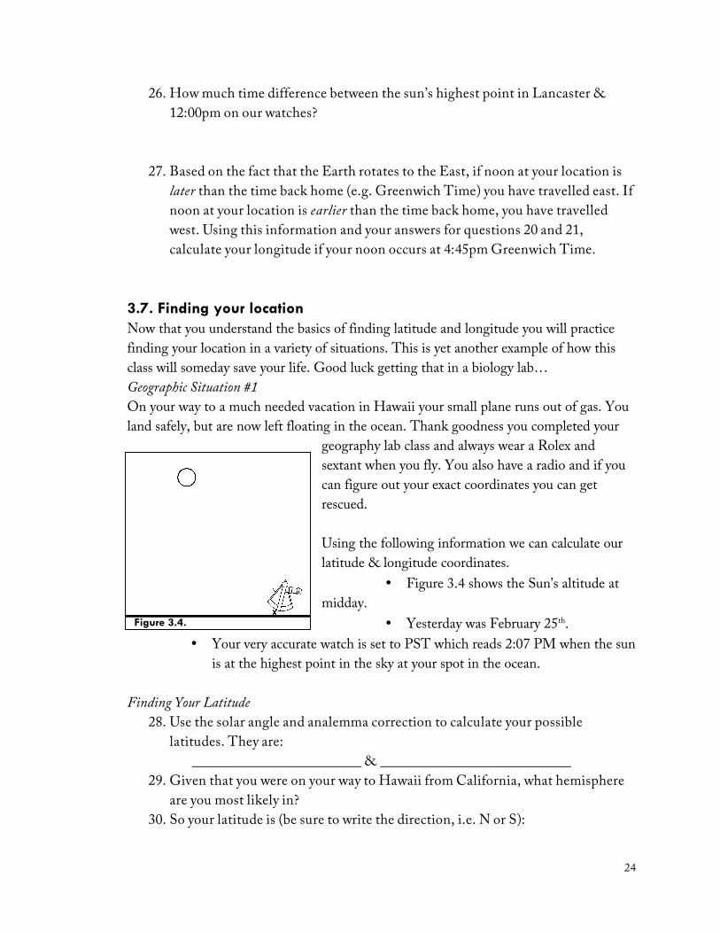
26. How much time difference between the sun’s highest point in Lancaster & 12:00pm on our watches?
27. Based on the fact that the Earth rotates to the East, if noon at your location is later than the time back home (e.g. Greenwich Time) you have travelled east. If noon at your location is earlier than the time back home, you have travelled west. Using this information and your answers for questions 20 and 21, calculate your longitude if your noon occurs at 4:45pm Greenwich Time.
3.7. Finding your location Now that you understand the basics of finding latitude and longitude you will practice finding your location in a variety of situations. This is yet another example of how this class will someday save your life. Good luck getting that in a biology lab… Geographic Situation #1 On your way to a much needed vacation in Hawaii your small plane runs out of gas. You land safely, but are now left floating in the ocean. Thank goodness you completed your
geography lab class and always wear a Rolex and sextant when you fly. You also have a radio and if you can figure out your exact coordinates you can get rescued. Using the following information we can calculate our latitude & longitude coordinates.
• Figure 3.4 shows the Sun’s altitude at midday.
• Yesterday was February 25th. • Your very accurate watch is set to PST which reads 2:07 PM when the sun
is at the highest point in the sky at your spot in the ocean. Finding Your Latitude
28. Use the solar angle and analemma correction to calculate your possible latitudes. They are:
________________________ & ___________________________ 29. Given that you were on your way to Hawaii from California, what hemisphere
are you most likely in? 30. So your latitude is (be sure to write the direction, i.e. N or S):
Figure 3.4.
25
Finding Your Longitude 31. First you need to compare local noon to the time at a known location. What is
the time difference between the time at your watch and local noon? 32. Convert that time to minutes (no hours)
33. What is the time difference as you travel one degree east or west (you answered
this in question 21)?
34. Using your answers for 31 and 32, convert the time minutes to longitude degrees.
35. What is the longitude of the controlling meridian for the time zone at your
known location?
36. Are you in the Eastern or Western hemisphere?
37. Are you east or west of your known location? How do you know?
38. Your longitude is (be sure to write the direction, i.e. E or W): Geographic Situation #2 Fortunately you paid attention in geography lab and were rescued from certain death in the Pacific Ocean. The stress of that ordeal led you take another vacation, this time driving across country to sunny Florida. Of course you bring your geography equipment with you just in case and while fiddling with your radio you pick up a faint cry for help:
Mayday... Mayday.... My yacht has sunk leaving me on a deserted island. The sun is directly overhead at its highest point each day. And my watch, which is set to Greenwich Mean Time, gives the time of 5:13 PM when it's noon here. There's a $10,000,000 reward for anyone who can save me before I go crazy!
Luckily the stranded wealthy person was very specific. That information along with the fact that today is May 15 should be enough to help you find him. What are the latitude & longitude coordinates where you will begin your search?

26
Geographic Situation #3 Geography has paid off once again! You collect the reward and are able to retire to a life of leisure. You quickly blow a large chunk of your money on a sailing yacht and crew. Money has made you lazy though and you allow others to do your navigation for you. While traveling in the South Pacific your navigator gets drunk and falls overboard. You haven’t been paying attention to where you are but know the next stop was to have been Singapore. You notice the Southern Cross constellation one evening and wake up in the morning with land in sight. What country are you looking at? Here are your clues:
• You are able to measure the solar angle at local noon as shown in Figure 3.5.
• Today is December 15. • Your Rolex, which was set to local time in Perth,
Australia reads 4:30 PM when the sun is at its highest point overhead. Luckily you kept a copy of your Essential World Atlas and De Blij et al’s Physical Geography on your ship just in case you had to look up Perth’s location and time zone…
39. What are your latitude & longitude coordinates? 40. What country are you closest to? 41. In what compass direction should you head if you want to get to Singapore?
Geographic Situation #4 You cancel the Singapore trip and instead head to the Seychelles. After exactly three months of island life, the sea is calling once again. A crew member mentions “I always wanted to see the Maldives…” After six days of debauchery and a lack of proper navigation (money certainly has changed you) you wake up becalmed. The sun is directly over head at its highest point and your watch, which you never bothered to change from Perth time, reads 10:20 AM.
42. What are your latitude & longitude coordinates? 43. Which direction should you go to get to the Maldives?
End of Lab 03
Figure 3.5