
Mountain-Block Hydrology and Mountain-Front … · Mountain-Block Hydrology and Mountain-Front...
23
Mountain-Block Hydrology and Mountain-Front Recharge * John L. Wilson and Huade Guan New Mexico Institute of Mining and Technology, Socorro, New Mexico In semiarid climates, a significant component of recharge to basin aquifers oc- curs along the mountain front. Traditionally called “mountain-front recharge” (MFR), this process has been treated by modelers of basins as a boundary condi- tion. In general, mountain-front recharge estimates are based on the general pre- cipitation characteristics of the mountain (as estimated, e.g., by the chloride mass balance and water balance methods), or by calibration of a basin groundwater model. These methods avoid altogether the complexities of the hydrologic sys- tem above the mountain front, or at best consider only traditional runoff process. Consequently hydrology above the mountain front is an area ripe for significant scientific advancement. A complete view would consider the entire mountain block system and examine hydrologic processes from the slope of the highest peak to the depth of the deepest circulating groundwater. Important aspects above the mountain front include the partitioning of rainfall and snowmelt into vegetation-controlled evapotranspiration, surface runoff, and deep infiltration through bedrock, especially its fractures and faults. Focused flow along mountain stream channels and the diffuse movement of groundwater through the underly- ing mountain block would both be considered. This paper first defines some key terms, then reviews methods of studying MFR in arid and semiarid regions, dis- cusses hydrological processes in the mountain block, and finally addresses some of the basic questions raised by the new mountain-block hydrology approach, as well as future directions for mountain-block hydrology research. * Preprint of paper to be published in Groundwater Recharge in A Desert Environment: The Southwestern United States, edited by Fred M. Phillips, James Hogan, and Bridget Scanlon, 2004, AGU, Washington, DC. 1. INTRODUCTION The term “mountain-front recharge” (MFR) is gen- erally used in arid and semiarid climates to describe the contribution of mountains regions to the recharge of aquifers in adjacent basins. Basin aquifer recharge is typically focused along stream channels and the moun- tain front; in many cases MFR is the dominant source of replenishment [Hely et al., 1971; Maurer et al., 1999]. Diffuse recharge of basin aquifers, through direct infiltration of precipitation, is limited or absent due to small precipitation volumes, deep vadose zones, and the water scavenging vegetation found in dry cli- mates [Foster and Smith-Carrington, 1980; Phillips, 1994; Izbicki ,et al., 2000; Flint, 2002a; Walvoord et al., 2002]. Mountains, due to orographic effects, re- ceive more precipitation than the basin floor, with a significant fraction in the form of snow. In addition, mountains have lower temperatures, and sometimes a larger surface albedo due to the snow cover, thus re- ducing the potential for evapotranspiration (ET). Mountains also have thin soils that can store less water, reducing the amount potentially lost by transpiration. Fast flow along bedrock fractures that underlie the thin soil cover may also limit water loss to ET (Plate 1). A study of 20 selected catchments worldwide shows that the area-weighted mountain contribution to annual river basin discharge is about 4 times that of the basin floor [Viviroli et al., 2003]. In arid and semiarid re- gions, the mountain contribution can be greater. MFR has been studied from one of two perspectives: (1) the traditional basin-centered view (Plate 2a), or (2) a mountain-centered view (Plate 2b). With a basin- centered perspective, the mountain front is viewed as a boundary condition for the basin aquifers, thus avoid- ing the complexities of the hydrologic system above the mountain front. Basin-centered methods include Darcy’s law calculations along the mountain front [Maurer and Berger, 1997] and calibration of ground- water models of the basin aquifer [Tiedeman et al., 1998a; Sanford et al., 2000]. With a mountain-centered
Transcript of Mountain-Block Hydrology and Mountain-Front … · Mountain-Block Hydrology and Mountain-Front...

Mountain-Block Hydrology and Mountain-Front Recharge*
John L. Wilson and Huade Guan
New Mexico Institute of Mining and Technology, Socorro, New Mexico
In semiarid climates, a significant component of recharge to basin aquifers oc-curs along the mountain front. Traditionally called “mountain-front recharge” (MFR), this process has been treated by modelers of basins as a boundary condi-tion. In general, mountain-front recharge estimates are based on the general pre-cipitation characteristics of the mountain (as estimated, e.g., by the chloride mass balance and water balance methods), or by calibration of a basin groundwater model. These methods avoid altogether the complexities of the hydrologic sys-tem above the mountain front, or at best consider only traditional runoff process. Consequently hydrology above the mountain front is an area ripe for significant scientific advancement. A complete view would consider the entire mountain block system and examine hydrologic processes from the slope of the highest peak to the depth of the deepest circulating groundwater. Important aspects above the mountain front include the partitioning of rainfall and snowmelt into vegetation-controlled evapotranspiration, surface runoff, and deep infiltration through bedrock, especially its fractures and faults. Focused flow along mountain stream channels and the diffuse movement of groundwater through the underly-ing mountain block would both be considered. This paper first defines some key terms, then reviews methods of studying MFR in arid and semiarid regions, dis-cusses hydrological processes in the mountain block, and finally addresses some of the basic questions raised by the new mountain-block hydrology approach, as well as future directions for mountain-block hydrology research.
* Preprint of paper to be published in Groundwater Recharge in A Desert Environment: The Southwestern United States, edited by Fred M. Phillips, James Hogan, and Bridget Scanlon, 2004, AGU, Washington, DC.
1. INTRODUCTION
The term “mountain-front recharge” (MFR) is gen-erally used in arid and semiarid climates to describe the contribution of mountains regions to the recharge of aquifers in adjacent basins. Basin aquifer recharge is typically focused along stream channels and the moun-tain front; in many cases MFR is the dominant source of replenishment [Hely et al., 1971; Maurer et al., 1999]. Diffuse recharge of basin aquifers, through direct infiltration of precipitation, is limited or absent due to small precipitation volumes, deep vadose zones, and the water scavenging vegetation found in dry cli-mates [Foster and Smith-Carrington, 1980; Phillips, 1994; Izbicki ,et al., 2000; Flint, 2002a; Walvoord et al., 2002]. Mountains, due to orographic effects, re-ceive more precipitation than the basin floor, with a significant fraction in the form of snow. In addition, mountains have lower temperatures, and sometimes a larger surface albedo due to the snow cover, thus re-
ducing the potential for evapotranspiration (ET). Mountains also have thin soils that can store less water, reducing the amount potentially lost by transpiration. Fast flow along bedrock fractures that underlie the thin soil cover may also limit water loss to ET (Plate 1). A study of 20 selected catchments worldwide shows that the area-weighted mountain contribution to annual river basin discharge is about 4 times that of the basin floor [Viviroli et al., 2003]. In arid and semiarid re-gions, the mountain contribution can be greater.
MFR has been studied from one of two perspectives: (1) the traditional basin-centered view (Plate 2a), or (2) a mountain-centered view (Plate 2b). With a basin-centered perspective, the mountain front is viewed as a boundary condition for the basin aquifers, thus avoid-ing the complexities of the hydrologic system above the mountain front. Basin-centered methods include Darcy’s law calculations along the mountain front [Maurer and Berger, 1997] and calibration of ground-water models of the basin aquifer [Tiedeman et al., 1998a; Sanford et al., 2000]. With a mountain-centered

MOUNTAIN-BLOCK HYDROLOGY AND MOUNTAIN-FRONT RECHARGE 2
perspective, precipitation amounts over the mountains are crudely related to MFR rates, and do not consider the subsurface hydrologic mechanics in the mountains. Examples of mountain-centered methods include: (1) comparing the geochemical or isotopic characteristics of mountain precipitation with the groundwater at the mountain front (e.g., the chloride mass balance method) [Dettinger, 1989; Maurer and Berger, 1997; Anderholm, 2000]; (2) using locally developed empiri-cal relations between MFR and precipitation [Maxey and Eakin, 1949; Anderson et al., 1992; Maurer et al., 1999; Anderholm, 2000]; and (3) subtracting estimated ET from precipitation [Feth, 1966; Huntley, 1979]. The studies of MFR in either perspective so far neglect detailed hydrologic processes in mountains.
Hydrologic processes in mountains have been stud-ied in detail at the hillslope scale, with a focus on streamflow responses to precipitation in humid regions (e.g., McGlynn et al., 2002; Peters et al., 1995; Tani, 1997). Few of these studies were conducted in arid and semiarid regions [Wilcox et al., 1997; Puigdefabregas et al., 1998]. Hillslope studies typically only examine hydrologic processes in the thin soil layer above the bedrock surface (Plate 1). Studies of semiarid moun-tain hydrologic processes below the bedrock surface have mostly been limited to Yucca Mountain, the pro-posed vadose zone nuclear waste repository in Nevada, with an emphasis on solute migration issues.
Plate 1. Vegetation, thin soil cover, and limestone bedrock on a hillslope of the eastern Sandia Mountains, New Mexico. The rock is dipping to the north (left). The vegetation is mainly Pinõn and Juniper.
Hydrologic science above the mountain front, incor-
porating a full view of the entire mountain block sys-tem and not just the thin soil cover and its vegetation, is an area ripe for significant scientific advancement. This more complete perspective examines hydrologic processes from the slopes of the highest peak to the depths of deepest circulating groundwater. It includes the focused flow of mountain stream channels, and the
diffuse movement of groundwater through the sur-rounding and underlying mountain blocks. It considers recharge from rainfall, snowmelt, surface runoff, and through fractures and faults, as well as water returned to the atmosphere through vegetation-controlled evapotranspiration. When water is discharged from the mountain block to the adjacent basin, through focused and diffuse surface and subsurface components, it be-comes MFR.
Plate 2. Two different remote sensing perspectives on MFR. (a) The valley-centered perspective is represented by this horizontal view of the Albuquerque Basin bounded by the Sandia Mountains Mountains (~25 km visible in this view). The view is east across the city of Albuquerque, with a 5-times vertical exaggeration (TM image 7, 4, 2 bands draping over a DEM). (b) The mountain-centered perspective is rep-resented by this ~130 km wide vertical view of the southern Sangre de Cristo Mountains, New Mexico and part of Rio Grande valley, with a 5-times vertical exaggeration (TM 7, 4, 2 bands draping over a DEM). The east slopes of the Jemez Mountains are on the left.
MFR is an important, if not predominant, source of
recharge to basins in arid and semiarid regions, how-ever it is simultaneously the least well quantified. Es-timates of the basin-margin recharge to the Middle Rio Grande Basin vary by one order of magnitude [Sanford et al., 2000]. Uncertainty is amplified by climate vari-ability, climate change, and increasing anthropogenic
WILSON AND GUAN
3
disturbances that alter mountain environments [Luck-man and Kavanagh, 2002], mountain hydrology, and thus mountain-front recharge. Some direct human im-pacts (e.g., septic systems, transportation, resort devel-opment, mine dewatering/contamination) also affect water quality in mountains. A more complete approach to studying MFR in a mountain-centered perspective would provide observations of the temporal and spatial variations of its different components, and improve prediction of how the mountain hydrologic system (including MFR) responds to climate and to local dis-turbances such as changing vegetation patterns. Moun-tain-centered observations and predictions are essential for effective groundwater resource management in adjacent basins.
This paper first defines some key terms, then reviews methods of studying MFR in arid and semiarid regions, describes hydrologic processes in the mountain block, and finally addresses some of the basic questions raised by a proposed new mountain-block hydrology approach, as well as future directions for mountain-block hydrology research.
2. MOUNTAIN BLOCK, MOUNTAIN FRONT, AND RECHARGE
A mountain block includes all the mass composing the mountains, including vegetation, soil, bedrock (ex-posed and unexposed), and water. A mountain block can be formed through a number of geological proc-esses, such as normal faulting in extensional settings, thrust faulting in compressional settings, and volcanic eruption. These processes yield the mountain block’s most important characteristic: significant topographic relief. Mountain-block hydrology examines all hydro-logic processes in the mountain block, including the temporal and spatial distribution of precipitation, vege-tation interception, snow and snowmelt, ET, runoff, interflow (throughflow) in the soil layer, water flow through bedrock matrix and fractures, and surface wa-ter and subsurface water interactions.
The term mountain-front recharge is frequently used to describe the contribution from mountains to ground-water recharge of the adjacent basins along the moun-tain front. The mountain front is positioned somewhere between the mountain block and the basin floor. However, a clear and consistent definition of the mountain front is lacking. Estimates of mountain-front recharge are consequently ambiguous and difficult to compare. Is the mountain front a strict line or a narrow zone? If it is a line, how is it determined? If it is a zone, what criteria are used to identify this zone?
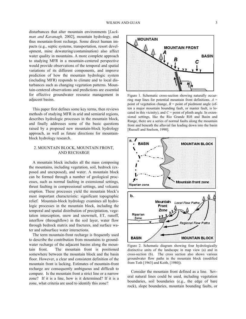
Figure 1. Schematic cross-section showing naturally occur-ring map lines for potential mountain front definitions. A = point of vegetation change, B = point of piedmont angle (of-ten a major mountain bounding fault, or master fault, is lo-cated in this vicinity), and C = point of plinth angle. In exten-sional settings, like the Rio Grande Rift and Basin and Range, there are a series of normal faults along the mountain front and beneath the alluvial fan leading down into the basin [Russell and Snelson, 1990].
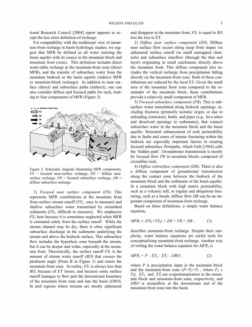
Figure 2. Schematic diagram showing four hydrologically distinctive units of the landscape in map view (a) and in cross-section (b). The cross section also shows various groundwater flow paths in the mountain block (modified from Toth [1963] and Keith, [1980]).
Consider the mountain front defined as a line. Sev-eral natural lines could be used, including vegetation boundaries, soil boundaries (e.g., the edge of bare rock), slope boundaries, mountain bounding faults, or

MOUNTAIN-BLOCK HYDROLOGY AND MOUNTAIN-FRONT RECHARGE 4
even the snow line. Based on Ruxton and Berry’s [1961] description of landforms and weathering pro-files in arid regions, we define three alternative defini-tions of the mountain front boundary: the point where there is a change in vegetation (Figure 1, point A), the point where the mountain abuts the piedmont, often corresponding to a change in soil type and presence of the mountain bounding faults (point B), and the plinth angle where the piedmont meets the edge of the basin floor (point C). Each of these boundaries is a candi-date for defining the mountain front because each might represent a distinct hydrologic transition (Table 1).
Suppose instead the mountain front is defined as a transition zone between the mountain and the basin floor. Theoretically, any zone that utilizes the bounda-ries defined in Figure 1 can be a potential mountain
front zone. For the purpose of studying mountain-front recharge in arid and semiarid areas we believe that the piedmont zone (the area between points B and C) is the best definition of the mountain front. The streamflow at point B represents surface runoff from the mountain block; the stream loss between points B and C reflects the water returned to the atmosphere by ET and by recharge into the mountain front zone (and eventually to the basin aquifer). Mountain bounding faults are typically located within this zone, thus including their hydrologic effect on mountain-front recharge. With this defined as the mountain front zone, the landscape is then divided into four hydrologically distinctive ar-eas: mountain block, mountain front, basin floor, and discharge zones (e.g., phreatic playas and basin ripar-ian areas), illustrated in Figures 2a and 2b.
Table 1 Comparison of three potential boundaries for mountain front determination
Types of boundaries Significant change across the boundary
Advantage Disadvantage
A: Vegetation Vegetation type, Evapotranspiration.
Good for ecological study. Varies with climate, slope aspect, etc. Not good for studying mountain front recharge.
B: Piedmont angle Slope, soil, infiltration and runoff characteristics.
Good point to quantify surface runoff from the mountain, generally ac-companied with soil change and buried moun-tain bounding fault zone.
Recharge from surface runoff beyond this point is not included in mountain front recharge.
C: Plinth angle Slope, soil, surface structures.
Surface runoff measured past this point is definitely excluded from mountain front recharge.
May be covered by anthro-pogenic structures; the point is difficult to iden-tify.
MFR is defined by Keith [1980] as groundwater re-
charge to a regional (basin) aquifer at the margin of the aquifer that parallels a mountain area. MFR is often divided into two components [Anderson et al., 1992; Chavez et al., 1994a; Manning, 2002]: (1) subsurface inflow from the adjacent mountains; and (2) infiltration from streams near the mountain front. In this defini-tion, MFR includes the addition of water to the basin aquifer both from the saturated zone under the moun-tains and through the unsaturated zone at the mountain front. We, and others, call the first component “moun-tain-block recharge” [Manning, 2002]. Some scientists do not regard this as a component of recharge because it fails their strict definition of recharge as water reach-ing the water table through the unsaturated zone or
from direct contact with surface water bodies [Flint et al., 2001a]. With this definition, the combined satu-rated zone of mountain and basin is considered one system, and recharge is the process of adding water from above through the vadose zone. From this per-spective, “mountain-block recharge” would perhaps be termed “underflow” between two portions of the sys-tem. If instead we consider only the basin aquifer as the system of concern, the broader definition acknowl-edges that “recharge” occurs when water is added to the aquifer. Meinzer [1923] distinguished these two contributions to aquifer replenishment as direct re-charge (from the unsaturated zone) and indirect re-charge (from other saturated formations). A recent Na-
WILSON AND GUAN
5
tional Research Council [2004] report appears to ac-cept the less strict definition of recharge.
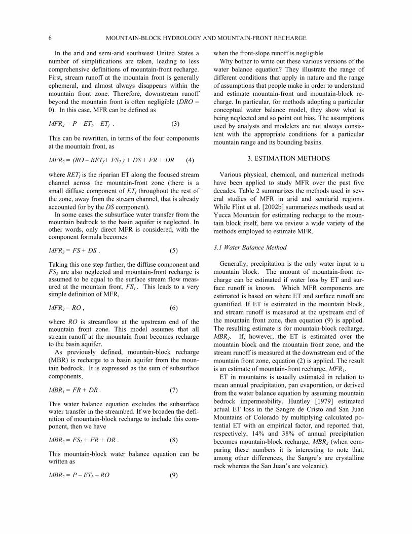
For compatibility with the traditional view of moun-tain-front recharge in basin hydrologic studies, we sug-gest that MFR be defined as all water entering the basin aquifer with its source in the mountain block and mountain front (zone). This definition includes direct water-table recharge at the mountain-front zone (direct MFR), and the transfer of subsurface water from the mountain bedrock to the basin aquifer (indirect MFR or mountain-block recharge). In addition to near sur-face (direct) and subsurface paths (indirect), one can also consider diffuse and focused paths for each, lead-ing to four components of MFR (Figure 3).
Figure 3. Schematic diagram illustrating MFR components. FS = focused near-surface recharge, DS = diffuse near-surface recharge, FR = focused subsurface recharge, DR = diffuse subsurface recharge.
1) Focused near surface component (FS). This
represents MFR contributions at the mountain front from surface stream runoff (FS1,, easy to measure) and shallow subsurface water transmitted by streambed sediments (FS2, difficult to measure). We emphasize FS2 here because it is sometimes neglected when MFR is estimated solely from the surface runoff. While the stream channel may be dry, there is often significant subsurface discharge in the sediments underlying the stream and above the bedrock surface. This subsurface flow includes the hyporheic zone beneath the stream, but it can be deeper and wider, especially at the moun-tain front. Theoretically, the surface runoff FS1 is the amount of stream water runoff (RO) that crosses the piedmont angle (Point B in Figure 1) and enters the mountain front zone. In reality, FS1 is always less than RO, because of ET losses, and because some surface runoff manages to flow past the downstream boundary of the mountain front zone and into the basin (DRO). In arid regions where streams are mostly ephemeral
and disappear at the mountain front, FS1 is equal to RO less the loss to ET.
2) Diffuse near surface component (DS). Diffuse near surface flow occurs along steep front slopes via ephemeral surface runoff (in small unmapped chan-nels) and subsurface interflow (through the thin soil layer) originating in small catchments directly above the mountain front. This diffuse component also in-cludes the vertical recharge from precipitation falling directly on the mountain-front zone. Both of these con-tributions are reduced by the local ET. Given the small area of the mountain front zone compared to the re-mainder of the mountain block, these contributions provide a relatively small component of MFR.
3) Focused subsurface component (FR). This is sub-surface water transmitted along bedrock openings, in-cluding fractures (primarily tectonic origin, or due to unloading extension), faults, and pipes (e.g., lava tubes and dissolved openings in carbonates), that connect subsurface water in the mountain block and the basin aquifer. Structural enhancement of rock permeability due to faults and zones of intense fracturing within the bedrock are especially important factors in creating focused subsurface flowpaths, which Feth [1964] calls the ‘hidden path’. Groundwater transmission is mostly by focused flow FR in mountain blocks composed of crystalline rock.
4) Diffuse subsurface component (DR). There is also a diffuse component of groundwater transmission along the contact zone between the bedrock of the mountain block and the sediments of the basin aquifer. In a mountain block with high matrix permeability, such as a volcanic tuff, or regular and ubiquitous frac-turing, such as a basalt, diffuse flow DR can be an im-portant component of mountain-front recharge.
Based on these definitions, a simple water balance equation,
MFR1 = (FS1+FS2) + DS + FR + DR , (1)
describes mountain-front recharge. Despite their sim-plicity, water balance equations are useful tools for conceptualizing mountain-front recharge. Another way of writing the water balance equation for MFR1 is
MFR1 = P – ETb – ETf – DRO , (2)
where P is precipitation input in the mountain block and the mountain-front zone (P=Pb+Pf , where Pb » Pf), ETb and ETf are evapotranspiration in the moun-tain block and mountain-front zone, respectively, and DRO is streamflow at the downstream end of the mountain-front zone into the basin.
MOUNTAIN-BLOCK HYDROLOGY AND MOUNTAIN-FRONT RECHARGE 6
In the arid and semi-arid southwest United States a number of simplifications are taken, leading to less comprehensive definitions of mountain-front recharge. First, stream runoff at the mountain front is generally ephemeral, and almost always disappears within the mountain front zone. Therefore, downstream runoff beyond the mountain front is often negligible (DRO = 0). In this case, MFR can be defined as MFR2 = P – ETb – ETf . (3)
This can be rewritten, in terms of the four components at the mountain front, as
MFR2 = (RO – RETf + FS2 ) + DS + FR + DR (4)
where RETf is the riparian ET along the focused stream channel across the mountain-front zone (there is a small diffuse component of ETf throughout the rest of the zone, away from the stream channel, that is already accounted for by the DS component).
In some cases the subsurface water transfer from the mountain bedrock to the basin aquifer is neglected. In other words, only direct MFR is considered, with the component formula becomes
MFR3 = FS + DS . (5)
Taking this one step further, the diffuse component and FS2 are also neglected and mountain-front recharge is assumed to be equal to the surface stream flow meas-ured at the mountain front, FS1,. This leads to a very simple definition of MFR,
MFR4 = RO , (6)
where RO is streamflow at the upstream end of the mountain front zone. This model assumes that all stream runoff at the mountain front becomes recharge to the basin aquifer.
As previously defined, mountain-block recharge (MBR) is recharge to a basin aquifer from the moun-tain bedrock. It is expressed as the sum of subsurface components,
MBR1 = FR + DR . (7)
This water balance equation excludes the subsurface water transfer in the streambed. If we broaden the defi-nition of mountain-block recharge to include this com-ponent, then we have
MBR2 = FS2 + FR + DR . (8)
This mountain-block water balance equation can be written as
MBR2 = P – ETb – RO (9)
when the front-slope runoff is negligible. Why bother to write out these various versions of the
water balance equation? They illustrate the range of different conditions that apply in nature and the range of assumptions that people make in order to understand and estimate mountain-front and mountain-block re-charge. In particular, for methods adopting a particular conceptual water balance model, they show what is being neglected and so point out bias. The assumptions used by analysts and modelers are not always consis-tent with the appropriate conditions for a particular mountain range and its bounding basins.
3. ESTIMATION METHODS
Various physical, chemical, and numerical methods have been applied to study MFR over the past five decades. Table 2 summarizes the methods used in sev-eral studies of MFR in arid and semiarid regions. While Flint et al. [2002b] summarizes methods used at Yucca Mountain for estimating recharge to the moun-tain block itself, here we review a wide variety of the methods employed to estimate MFR.
3.1 Water Balance Method
Generally, precipitation is the only water input to a mountain block. The amount of mountain-front re-charge can be estimated if water loss by ET and sur-face runoff is known. Which MFR components are estimated is based on where ET and surface runoff are quantified. If ET is estimated in the mountain block, and stream runoff is measured at the upstream end of the mountain front zone, then equation (9) is applied. The resulting estimate is for mountain-block recharge, MBR2. If, however, the ET is estimated over the mountain block and the mountain front zone, and the stream runoff is measured at the downstream end of the mountain front zone, equation (2) is applied. The result is an estimate of mountain-front recharge, MFR1.
ET in mountains is usually estimated in relation to mean annual precipitation, pan evaporation, or derived from the water balance equation by assuming mountain bedrock impermeability. Huntley [1979] estimated actual ET loss in the Sangre de Cristo and San Juan Mountains of Colorado by multiplying calculated po-tential ET with an empirical factor, and reported that, respectively, 14% and 38% of annual precipitation becomes mountain-block recharge, MBR2 (when com-paring these numbers it is interesting to note that, among other differences, the Sangre’s are crystalline rock whereas the San Juan’s are volcanic).
WILSON AND GUAN
7
Table 2 Quantitative assessment on mountain front recharge by various methods
Location Authors Methods MFR or MBR amount in mm/year (percentage of precipi-tation )
Precipita-tion mm/year
Notes
Wasatch Range / Weber Delta Dsitrict, Utah
Feth et al. [1966]
Water balance method, precipitation and ET estimated by increments of eleva-tion.
MBR2 = 201 (22%) 926 Streamflow at moun-tain front is 25% annual precipitation in the mountain.
San Juan Mtns / San Luis Valley, Colorado
Huntley [1979]
Water balance method, ET estimated from calculated potential, ET multiplied by crop coefficient.
MBR2 = (38%) Not re-ported
Volcanic rock with high permeability in the mountain.
Sangre de Cristo Mtns / San Luis Valley, Colorado
Huntley [1979]
Water balance method, ET estimated from calculated potential, ET multiplied by crop coefficient.
MBR2 = (14%) Not re-ported
Shists, gneiss, and granitic intrusives, well-cemented sedi-mentary rocks in the mountain.
White River Val-ley, Navada
Maxey and Eakin [1949]
Maxey-Eakin method. Not reported Not re-ported
Sandia Mtns / Albuquerque Basin, New Mex-ico
Anderholm [2000]
Precipitation-runoff regression method, using two empirical equations.
MFR4 = 23 (4.6%) (Waltemeyer model) MFR4 = 66 (13%) (Hearne and Dewey model)
510 Subsurface inflow and ET at mountain front was believed negligible.
Carson Mtns, Virgina Mtns / Eagle Valley, Navada
Maurer et al. [1997]
Chloride mass bal-ance.
MFR3 = 27 (7.8%) (data resulted from four subcatchments)
350 Weathered and frac-tured granitic, basal-tic and metamorphic rocks.
Sandia Mtns / Albuquerque Basin, New Mex-ico
Anderholm [2000]
Chloride Mass Bal-ance.
MFR3 = 31 (6.1%) 510 0.3 mg/l chloride conc. used for bulk precipitation.
Santa Catalina Mtns / Tucson Basin, Arizona
Chavez et al. [1994]
Analytical seasonal stream flow model with stochastic esti-mation procedures.
MBR2 = 1.1 (0.2%)
280-760
Layered gneiss with folds.
Carson Mtns, Virgina Mtns / Eagle Valley, Nevada
Maurer et al. [1997]
Darcy’s law. MFR1 = 31 (8.8%) [data resulted from four subcatchments]
350 Weathered and frac-tured granitic, basal-tic and metamorphic rocks.
Sandia Mtns / Albuquerque Basin, New Mex-ico
Tiedeman et al. [1998]
Modeling of basin aquifer, calibrated using in-verse method.
MFR1 = 132 (26%) 510 Precipitation data from Anderholm [2000].
Sandia Mtns / Albuquerque Basin, New Mex-ico
Sanford et al. [2000]
Modeling of basin aquifer, calibrated using 14C groundwater age
MFR1 = 15 (3%) 510 Precipitation data from Anderholm [2000].
Eagle Mtns / Red Light Draw Val-ley, Texas
Hibbs and Darling [1995]
2D Numerical model-ing of both mtns and valley area, calibrated using groundwater age.
MFR1 = 1.8 (0.6%) 300 Widespread, well-developed calcic soil horizon in basin.
Yucca Mtns, Nevada
Flint et al. [2001]
Modeling in moun-tains.
MBR1 = 4.5 (2.7%) 170 Welded and non-welded tuff.

MOUNTAIN-BLOCK HYDROLOGY AND MOUNTAIN-FRONT RECHARGE 8
Feth et al. [1966] calculated MBR2 from the Wasatch Mountains to the Weber Delta District of Utah using a similar approach. MBR2 was reported to be 22% of annual precipitation with an ET loss of 53% (Table 2). Hely et al. [1971] estimated MBR2 for another section of the Wasatch Mountains to be 19% annual precipita-tion, with an ET loss of 44% (reviewed by Manning [2002]).
The accuracy of a water balance approach depends mainly on the estimation of ET, which is difficult to quantify, especially for the complex terrain and varied vegetation of mountains. In semiarid regions, ET is a dominant water balance component even in mountains [Brandes and Wilcox, 2000]. The uncertainty of the ET estimate is amplified by the uncertainty of other bal-ance components. Take water balance equation (2) as an example. If the actual ET is 60% of P, and MFR1 is 20% of P, then a 20% uncertainty in the ET estimate leads to a 60% uncertainty in MFR1 , assuming that P and DRO are measured exactly. This undermines the reliability of MFR quantification using the water bal-ance method.
Due to large uncertainty in ET quantification, ET is often empirically related to the local mean annual pre-cipitation, reflecting a direct function between MFR and the mountain’s mean annual precipitation. Maxey and Eakin [1949] considered the high spatial variation of precipitation in mountains and demonstrated an em-pirical relationship between precipitation zones and the MFR to groundwater basins in Nevada. In the Maxey-Eakin method, MFR is estimated by the following steps [Avon and Durbin, 1994]: (1) identifying several mean annual precipitation zones; (2) assigning each zone a scaling factor to account for the loss of water by ET and runoff; and (3) summing the recharge amount of each zone. Since, both ET and runoff loss is consid-ered in Maxey-Eakin method, the recharge estimate is conceptually either MBR2 or MFR1, depending on the spatial extent of precipitation estimation and the loca-tion of runoff estimation (see above). Since the Maxey-Eakin method crudely considers spatially distributed precipitation, it is preferable to other water balance methods that use only a single scaling factor for ET for an entire mountain area. Avon and Durbin [1994] re-ported that applications of the Maxey-Eakin method in Nevada were generally in fair agreement with esti-mates from other independent methods.
More recently, Anderson [1992] presented an em-pirical relationship between the total volume of direct MFR (or MFR3) and the total volume of mountain pre-cipitation exceeding 203 mm, based on basin-scale water balance estimates in south-central Arizona and
parts of adjacent states. This relation can be approxi-mated by
98.0
3 )203(042.0 −= mPMFR , (10)
where MFR is direct mountain-front recharge in mm per year, and Pm is mean annual precipitation in mm per year.
Maurer and Berger [1997] gave another empirical regression for mountain water yield (including surface runoff and subsurface flow, approximately equivalent to MFR2) at Carson Basin, Nevada,
43.25
2 1084.2 mPMFR −×= , (11)
where Pm is the mean annual precipitation in mm per year.
When estimated recharge by the Maxey-Eakin method is plotted against the mid-value of each of four precipitation zones, with Pm = 8-12, 12-15, 15-20, and >20 inches, and with scaling factors 0.03, 0.07, 0.15, and 0.25, respectively (for the White River Basin, Ne-vada [Maxey and Eakin, 1949]), another power law empirical relationship is revealed,
72.39109 mPMFR −×= , (12)
where Pm is the mean annual precipitation in mm per year. Equation (12) deviates from Maxey-Eakin esti-mates when Pm > 600mm ≅ 23.6 inches.
Figure 4. MFR vs. mean annual precipitation for three em-pirical relations provided by Anderson [1992], Maurer and Berger [1997], and Maxey and Eakin [1949], equations (10)-(12), respectively. Note that Anderson’s equation gives direct MFR, while Maurer and Berger’s version gives the total wa-ter yield [both surface and subsurface] from the mountain.
These three empirical equations (10)-(12) provide
substantially different MFR estimates (Figure 4), even though they were all developed for portions of the Ba-sin and Range Province of the southwestern United

WILSON AND GUAN
9
States, and have somewhat similar climates. Although different MFR components are quantified in these equations, the large deviation between MFR3 and MFR2, i.e. (10) and (11), suggests that these empirical estimates are likely restricted to the locale where they were developed and should not be transferred to other areas.
3.2 Precipitation-Runoff Regression Method
When subsurface recharge (MBR2) is negligible, stream runoff at the mountain front (runoff measured at point B in Figure 1, or RO) may be considered the total contribution to MFR [Anderholm, 2000]. The moun-tain-front recharge estimate is given by MFR4 in equa-tion (6). Regression analysis can be used to find the relationship between runoff from a mountain area and the mean annual precipitation [Waltemeyer, 1994; Maurer and Berger, 1997] or winter precipitation [Hearne and Dewey, 1988] for that mountain area. Three assumptions are implicit in the application of a precipitation-runoff regression method to estimate MFR: (1) all steam runoff recharges at the mountain front (i.e., RETf and DRO are negligible); (2) interflow (FS2) in the stream sediments is negligible compared to the stream runoff; and (3) the bedrock in the mountain block is impermeable.
In arid and semiarid areas, most streams at the moun-tain front are ephemeral, and most water infiltrates into the underlying basin sediments. Does all this water actually recharge the basin aquifer or is some lost to near channel ET? Stream flow at the mountain front can result from intense convective storms during the summer or spring snowmelt. During the snowmelt period, the stream may flow for a few months and, before the start of the growing season, ET loss may be small in comparison to the water that becomes re-charge. In summer, the stream only flows for a few hours or days following a storm and ceases between storms. ET loss can be substantial in this situation. Izbicki [2002] estimates that recharge over the 15-km length of Oro Grande Wash in the Mojave Desert, is about one-tenth the average streamflow as reported by Lines [1996]. This suggests that much of the stream-flow along the wash is lost by ET.
Besides the surface runoff at the mountain front, some shallow subsurface flow in the channel sediments may contribute to the focused recharge along the chan-nel. How does this subsurface flow (FS2) recharge compare to the surface runoff? Wroblicky et al. [1998] used numerical modeling to study the cross-sectional area and temporal variation of the lateral hyporheic zone underlying mountain streams in two geologic
environments. Their results suggest that the hyporheic zone can conduct significant water into the mountain front. At Clear Creek (10,000 acres) of the Carson Range, Nevada, [Maurer and Berger, 1997] subsurface flow in the sediments was about 4% of the annual pre-cipitation, and 23% of the surface runoff.
There are also reports that subsurface flow through mountain bedrock can be important [e.g., Maurer and Berger, 1997]. Thus, the three basic assumptions for precipitation runoff regression method are not always reasonable. The first assumption, neglecting RETf and DRO, leads to an overestimate of MFR, while the last two assumptions, neglecting FS2, FR and DR, result in an underestimate. While these biases may compensate for each other, sometimes yielding reasonable esti-mates of MFR, the precipitation-runoff regression method is conceptually less reasonable than the water balance method. Its empirical nature and bias makes the precipitation-runoff regression method less useful for predicting the effects of climate and land use change, and non-transferable to other regions.
3.3 Chloride Mass Balance Method
The chloride mass balance method is commonly used to estimate groundwater recharge in arid and semiarid areas. Recharge estimates on the basin floor use the chloride profile in the upper 10-15 meters of the vadose zone [Scanlon et al., 1997, 2002; Walvoord et. al, 2002]. A different approach must be used in mountains, which have only a few tens of centimeters of soil cover over the bedrock. To estimate MFR, the chloride concentration of groundwater resulting from MFR is compared to that of bulk precipitation, to give the fraction of precipitation which results in recharge [Dettinger, 1989; Maurer and Berger, 1997; Ander-holm, 2000]. When integrated over the entire moun-tain block, this method ignores the complex hydrologic processes within the mountain block. The chloride mass balance method can be expressed as
g
rp
CRCPC
MFR−
= (13)
where Cg is the chloride concentration in MFR groundwater, P is the precipitation on the mountain, Cp is chloride concentration in bulk precipitation, and R and Cr are respectively the runoff and its chloride con-centration at the mountain front.
Major assumptions include: (1) that the bulk pre-cipitation (dry fall and precipitation) is the only source of chloride in the system, and chloride is inert in the system; (2) that the chloride deposition rate and mean annual precipitation rate are accurately estimated and

MOUNTAIN-BLOCK HYDROLOGY AND MOUNTAIN-FRONT RECHARGE 10
have been constant over the period of groundwater residence time within the mountain block; and (3) that the measured chloride concentration of groundwater at the mountain front accurately represents the mean value of total groundwater resulting from MFR. Re-garding the first assumption, the chloride mass balance method may not work in mountain blocks that have a chloride source in the rocks (e.g., marine-derived sedimentary rock [Claassen and Halm, 1996]) or a chloride source due to anthropogenic activities (e.g., the application of road salt) [Maurer and Berger, 1997]. Failure to account for additional chloride sources leads to an underestimate of MFR. As for the second assumption, the chloride mass balance method only applies to a mountain hydrologic system in equi-librium with current climate conditions. Changes in the average precipitation rate or chloride deposition rates over the period of groundwater residence time within the mountain block may lead to over- or under-estimates depending on the nature of the change. The third assumption may lead to an erroneous MFR esti-mate when there is significant spatial variation in MFR. For example, if the measured MFR does not include some fast-flow deep MBR (that experiences less ET loss), MFR will be underestimated. Specifi-cally, if the water is sampled at mountain front alluvial aquifer, the chloride mass balance more possibly gives MFR3, shown in equation (5).
3.4 Darcy’s Law
MFR can be estimated using a simple Darcy’s law calculation, provided that water equipotential lines and the hydraulic properties of sediments and rocks at the mountain front are known [Hely et al., 1971; Belan and Matlock, 1973; Maurer and Berger, 1997; NRC, 2004]. This method is based only on observation data at the mountain front, avoiding the complex hydrologic processes in the mountain block but potentially missing MFR contribution from some deep MBR flow paths. The accuracy of this method strongly depends on the estimated aquifer hydraulic parameters. Furthermore, a simple calculation of Darcy’s law cannot deal with complex geological structures and heterogeneity of the aquifer materials that are often present at the mountain front [Koltermann and Gorelick, 1996].
3.5 Numerical Modeling of Basin Groundwater
Due to the scarcity of surface and subsurface hydro-logic data in mountains, MFR is often estimated based on hydrologic modeling of the adjacent basins. Few basin numerical simulations have been extended to the
mountain block [Hibbs and Darling, 1995; Tiedeman et al., 1998b; Manning, 2002; Keating et al., 2003]. In a basin-centered view, MFR is a boundary condition of the basin aquifer and calibration of a numerical model, based on observed data, is used to estimate the amount of MFR [Tiedeman et al., 1998a; Sanford et al., 2000]. In calibration of a groundwater model, recharge rates and hydraulic conductivity are highly correlated and therefore the accuracy of the recharge estimate strongly depends on the availability of hydraulic conductivity data, a parameter that can range over several orders of magnitude. Keating et al. [2003] show that simulation results also depend on the spatial resolution of the hy-drographic units used by the model.
Model calibration uniqueness issues are especially important for this approach. In cases where only basin hydraulic head data are available, the ratio of recharge to hydraulic conductivity can be estimated, but not the conductivity itself [Townley and Wilson, 1989; San-ford, 2002; Scanlon et al., 2002]. The addition of flux observations (e.g., baseflow in streams) or groundwa-ter ages can improve uniqueness and the accuracy of the recharge estimate [Sanford, 2002]. For example, the addition of 14C groundwater age data in calibrating a groundwater model of the Albuquerque Basin pro-vided estimated MFR one order of magnitude less than when calibrated without the data [Sanford et al., 2000]. This complementary data could also be used to esti-mate how recharge rates have varied over the last 30 kyrs [Sanford, 2002]. Manning [2002] shows that groundwater temperature can be another excellent complement to obtain more unique estimates of moun-tain-block recharge.
3.6 Hydrologic Modeling in Mountains
There have been extensive field observations and many numerical simulations of water flow and solute transport, in both the unsaturated and saturated zones, at Yucca Mountain [Wittwer et al., 1995; Ho et al., 1995; Bagtzoglou et al., 2000; Doughty, 1999; and Flint et al., 2001a]. This attention on a single geologi-cal and climatic setting has helped improve our under-standing of subsurface hydrologic processes in moun-tain blocks, yet that understanding remains primitive. The Yucca Mountain studies have not dynamically coupled surface and subsurface processes, and obvi-ously do not address subsurface flow in more humid, high-elevation mountain blocks common throughout the western U.S., or in different mountain geological settings.
Several other groundwater models focus on ground-water flow within the mountain block itself, taking as a

WILSON AND GUAN
11
boundary condition percolation into the bedrock from the surface. These are usually models that extend out into the basin (see previous section). For example, Manning [2002] developed a two-dimensional steady state cross-sectional model of the Wasatch Mountains near Salt Lake City, with prescribed recharge into the mountain block, estimated by model calibration (see previous section). One difficulty with this approach is that, under steady flow conditions, the prescribed re-charge rate into the block simply becomes the rate of discharge from the block; that is, it becomes the rate of mountain-block recharge (MBR) to the adjacent ba-sin(s).
The many other studies of mountain hydrology con-sidered near surface hydrologic processes, but give little or no attention to deep percolation into the moun-tain block or to any other deep subsurface processes within the block. These studies have examined a wide variety of settings, sometimes focused at the hillslope scale, and other times at surface watersheds. For ex-ample, Kafri and Ben-Asher (1976) used a numerical model to simulate individual rainfall events resulting in percolation through thin mountain soil cover, without further investigating water flow at depth. An interest-ing contrast are the papers by Chavez et al. [1994a and 1994b], who developed an analytic model with a sto-chastic estimation procedure to estimate stream runoff and MBR (=MBR1 or possibly MBR2). This model ap-plied Eagleson’s [1978] vegetal equilibrium hypothesis to estimate ET based on vegetation cover. The increas-ing availability of remote sensing data (e.g., precipita-tion, fractional vegetation cover, interception, ET, etc.) and high resolution DEMs, together with improved models of vegetation and the surface energy balance, will substantially improve the feasibility of coupled models of the surface and subsurface of mountain blocks.
3.7 Environmental Tracers
Environmental tracers other than chloride have also been intensively used to study water flow and estimate groundwater recharge [Scanlon, 1992; Phillips, 1994; Unnikrishna et al., 1995; Scanlon et al., 1997]. The vertical concentration profile in the thick vadose zone of basin floor gives clues to its history of water flow and groundwater recharge. This approach is some-times also applied on the mountain hillslopes with good soil covers. Newman et al. [1996] used profiles of chloride and aqueous stable isotopic composition to estimate the evaporation depth and the downward wa-ter flux through the soil layers near Los Alamos, New Mexico. However, thin soil cover, root controlled sub-
horizontal soil macropores [e.g., Wilcox et al., 1997], and fractures in the bedrock make profile methods much less useful in mountains than on basin floors. Instead, integrated tracer measures and ratios are used, in which concentrations in MFR components are exam-ined and compared to each other and to precipitation, as we earlier saw with the chloride mass balance method.
The stable isotopic composition of water (δ2H and δ18O) is the most frequently used environmental tracer. Stable isotope composition of precipitation varies with altitude and season. In the Southwestern United States this is useful for determining the relative importance of winter and summer (monsoon) precipitation for groundwater recharge [Simpson et al., 1972; Cunning-ham et al., 1998; Winograd et al., 1998; Newman and Duffy, 2001] and for identifying the location of this recharge (mountain vs. basin) [Eastoe et al, this vol-ume; Plummer et al., this volume]. Its not only used in the southwest, Abbott et al. [2000] identified two dis-tinctive recharge zones in a mountain in Vermont, USA, by comparing the stable isotopic compositions of precipitation and groundwater.
Using multiple conservative environmental tracers it is possible to delineate detailed groundwater recharge paths and quantities at a higher spatial resolution. Adar et al. [1990] used environmental tracers (ions and O/H isotopes) combined with a mixing-cell model to quantitatively assess the spatial distribution of MFR. Some radioactive isotopes can be used to obtain groundwater residence times and thus to estimate re-charge rates. Guerin [2001] reported fast fracture flow in Yucca Mountain based on tritium and 36Cl data. Recently, dissolved gases in groundwater have been used to estimate the elevation of mountain-block re-charge [Manning and Solomon, this volume].
3.8 Other Methods
Temperature profiles in the near surface have been used to estimate water percolation rates under the ephemeral streambeds along the mountain front [Nis-wonger and Constantz, 2000]. MFR from stream flow infiltration can be calculated, given that the stream timing and saturated channel width are known. Reiter [2000] used the temperature profile at depth in the ba-sin aquifer to estimate the lateral flow rate due to MFR. While this may not provide a quantitative estimate of MFR, it can show evidence of MFR. Manning [2002] found that a heat and fluid flow model calibrated with temperature data from basin wells could place impor-tant constraints on MBR. Together, these studies sug-

MOUNTAIN-BLOCK HYDROLOGY AND MOUNTAIN-FRONT RECHARGE 12
gest that temperature data could be very useful in quan-tification of MFR.
In addition to these physical tools, Duffy and col-leagues have used time series analysis tools in order to investigate the multiple paths that water can take from the mountain top to the basin floor, with water moving back and forth between the mountain streams and the underlying mountain block. They combine multichan-nel, singular-spectrum data analysis with low-dimensional models to understand the temporal and spatial characteristics of hydrologic processes in moun-tains [Shun and Duffy, 1999; Brandes et al., 1998; Newman and Duffy, 2001].
4. MOUNTAIN BLOCK HYDROLOGY
We have seen that most studies of MFR avoid the complexity of hydrologic processes within and on mountain blocks. While near-surface hydrologic proc-esses have been investigated at the hillslope and water-shed scales, these studies almost always assume that the bedrock is impermeable. Likewise, some deep bedrock processes have been investigated for locations like Yucca Mountain and the Wasatch Mountains out-side of Salt Lake City, but with an assumed percolation rate at the top of the bedrock surface. There are few integrative studies that bring these two fields together for a full view of the mountain hydrologic system.
Meteorological, hydrologic, and ecological condi-tions vary considerably across a mountain due to the steep altitude gradient. Compared to the basin floor, a mountain block provides less storage for water, and thus is more sensitive to climatic changes. Small varia-tions in atmospheric forcing on the mountain block may cause detectable hydrologic impacts, including the occurrence of springs, the amount and distribution of snow, vegetative cover, and MFR.
Mountain-block hydrology would address these con-ditions through the integrated study of processes across a variety of temporal and spatial scales. For example, mountain-block recharge to an adjacent basin requires that water enter the block in the first place. This takes place at the hillslope scale, where precipitation is parti-tioned into deep percolation that enters the mountain block and to other processes. Upon entering the block some water may then discharge to head-water or higher-order streams, and the block may receive other water from the streams, both occurring along a range of shallow and deep flow paths. Water leaves the mountain block as run-off (RO, as defined in Section 2) originated as surface runoff from rain and snowmelt, as interflow through the shallow soil cover, or as in-trablock discharge of shallow or deep mountain-block
groundwater. In mountain-block hydrology we expect multiple exchanges of water between these different reservoirs, controlled by topography, geology, soil cover and vegetation, and leading to a confusion of response and residence time scales.
Among the many space scales we believe that the two most important for the study of mountain-block hydrology are the hillslope scale and the scale of the entire mountain block. It is at the hillslope scale that water enters the block, a result of partitioning of pre-cipitation. It is the scale of the mountain block that determines surface, shallow (local), and deep (re-gional) flow pathways, and how they are linked in time and space.
An integrated mountain-block hydrologic model would allow us to predict changes in MFR in response to climate change and variability, vegetation change (including the effects of fire), and direct human im-pacts. But a sound understanding of mountain-block hydrology has other benefits, such as the accurate pre-diction of water-related geological hazards in moun-tains [Bell, 1998]. In this section the components and processes that comprise mountain-block hydrology are discussed, stressing first the hillslope scale and then the entire mountain block. At first reading this review may appear to be a primer on hydrology, but we use it to point out the processes and problems that are espe-cially important in mountain-block hydrology.
4.1 Precipitation
Precipitation is the only water input to the mountain block. Temporal and spatial variability of precipita-tion, as well as its effects on hydrologic processes, has been recognized as important [e.g., Goodrich et al., 1995]. Because of topographic complexity and eleva-tion, precipitation varies even more markedly within a mountain block and is difficult to measure. The prob-lem of measurement is exacerbated by a lack of pre-cipitation gauge stations in mountains. Recently, radar has improved the estimation of spatially distributed precipitation; however, beam blockage, underestima-tion, and non-detection of precipitation are significant problems when radar is used in mountainous terrains [Young et al., 1999].
Geostatistics and other tools can be used to synthe-size spatial distribution estimates of mountainous pre-cipitation. In addition to rain gauge measurements and radar, secondary variables, such as terrain and atmos-pheric characteristics that correlate with precipitation, are used to estimate precipitation distribution [Hevesi et al., 1992; Goovaerts, 2000; Kyriakidis et al., 2001].
WILSON AND GUAN
13
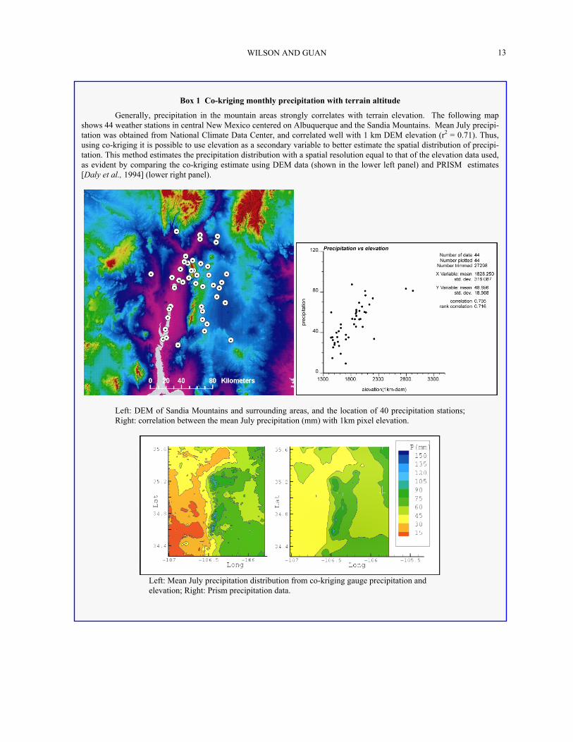
Box 1 Co-kriging monthly precipitation with terrain altitude
Generally, precipitation in the mountain areas strongly correlates with terrain elevation. The following map shows 44 weather stations in central New Mexico centered on Albuquerque and the Sandia Mountains. Mean July precipi-tation was obtained from National Climate Data Center, and correlated well with 1 km DEM elevation (r2 = 0.71). Thus, using co-kriging it is possible to use elevation as a secondary variable to better estimate the spatial distribution of precipi-tation. This method estimates the precipitation distribution with a spatial resolution equal to that of the elevation data used, as evident by comparing the co-kriging estimate using DEM data (shown in the lower left panel) and PRISM estimates[Daly et al., 1994] (lower right panel).
Left: DEM of Sandia Mountains and surrounding areas, and the location of 40 precipitation stations; Right: correlation between the mean July precipitation (mm) with 1km pixel elevation.
Left: Mean July precipitation distribution from co-kriging gauge precipitation and elevation; Right: Prism precipitation data.

MOUNTAIN-BLOCK HYDROLOGY AND MOUNTAIN-FRONT RECHARGE 14
In mountainous terrain precipitation generally corre-lates well with elevation, providing a strong secondary variable to improve the estimate of spatially distributed precipitation (Box 1).
Accuracy of precipitation gauge measurement is also a significant concern [Goodrich et al., 1995]. Major systematic errors result from the wind’s influence on falling precipitation, rain gauge evaporation, and wet-ting of the walls of rain gauge [Lapin, 1990]. Wind speed is the most important factor in determining gauge error [Nespor and Sevruk, 1999], especially when snow and mixed precipitation falls during the winter [Yang et al., 1999]. Precipitation intensity also contributes to wind-induced measurement error. These problems exist for all gauge measurements but are more challenging in mountains because of complex terrain and extreme weather conditions. Before using rain gauge data it is important to assess the potential magnitude of these errors and make the necessary cor-rections.
Snow and ice pose another problem to mountain hy-drology. In most mountains, winter precipitation falls in the form of snow. Afterwards the snow is redistrib-uted by strong winds and avalanches. This adds to the spatial variability inherited from the snowfall. In western United States, snow water equivalence (SWE) is estimated at over 600 SNOTEL sites, many located in mountainous headwater catchments, but which have poor spatial coverage for any one basin or range. Mountain hydrology requires a more detailed mapping of the spatial statistics and distribution of SWE [Balk and Elder, 2000; Marks et al., 2002], using remote sensing and other tools. Another problem of snow and ice hydrology is the timing of the snowmelt. Solid wa-ter is not immediately active in the hydrologic proc-esses; therefore it is necessary to determine when melt occurs and the equivalent liquid volume. In addition to locking water in a solid form, snow cover dramatically changes the surface albedo, altering the energy balance and consequently changing the dynamics of mountain hydrology. Two types of models are currently applied to estimate snowmelt rate: energy-balance models and temperature-index models [Dingman, 1994]. The en-ergy-balance model involves more physical processes and thus requires substantial data [Brock and Arnold, 2000; Marks et al., 2002]. The temperature-index model is less complex, based only on temperature dis-tribution that may be related to topographic data (e.g. DEM).
4.2 Interception
Not all measured precipitation reaches the ground surface; some is lost through interception by the vege-tation canopy. In some tropical forests canopy inter-ception may approach 50% of gross precipitation [Schellekens et al., 1999]. In semiarid regions, where vegetation cover is generally sparse, interception is less but may still be as much as 30% of the gross annual rainfall [Llorens and Gallart, 2000; Navar and Bryan, 1990]. Interception loses for the vegetation found in the mountains of the southwestern Unitied States has not been well studied.
A water balance for interception [Crockford and Re-chardson, 1990] illustrates some of the many processes that must be accounted for before the precipitation reaches the ground,
I = E + S = P – TF – SF , (14)
where I = interception, E = water evaporated during the precipitatio event, S = water stored in vegetation during the event and evaporated after the event, P = gross precipitation, TF = throughfall, and SF = stem flow.
The magnitude of interception is controlled by vegeta-tion characteristics (areal vegetation density, vegetation type, leaf area index, etc.) and meteorological charac-teristics (such as precipitation form, intensity and dura-tion, temperature, and wind speed). For continuous precipitation events, water evaporation during the storm is negligible, thus interception approaches the canopy storage capacity. For intermittent events, water evaporated during the storm can be several times the canopy storage capacity, leading to greater interception losses.
4.3 Evapotranspiration
Hydrologically active water (from rainfall and snowmelt) at the ground surface partitions into surface runoff, interflow within the soil and sediments at the surface, ET, and deep percolation through bedrock fractures and matrix. In arid and semiarid mountain environments ET represents the largest water loss from the mountain block [Brandes and Wilcox, 2000]. ET can be estimated from point measurements, as with (1) lysimeters [Gee et al., 1991; Tomlinson, 1996], (2) the Bowen ratio method [Gay, 1991; Stannard, 1991; and Tomlinson, 1996], (3) the eddy-covariance method

WILSON AND GUAN
15
[Tanner et al., 1985; Weaver, 1991], or (4) by calculat-ing potential ET derived from point meteorological data or from pan evaporation [Beyazgul et al., 2000; Allen, 2000]. ET can be estimated from areal meas-urements with instruments such as (5) scintillometers [Meijninger and de Bruin, 2000], or (6) derivation us-ing remote sensing data [Bastiaanssen et al., 1998; Granger et al., 2000; Caparrini and Castelli, 2002; Nishida et al., 2003]. ET can also be derived from (7) hydrologic modeling [Droogers, 2000; Kite, 2000]. Most ET quantification in semiarid and arid regions has been conducted on irrigated agricultural areas. Some ET measurement has been done on naturally vegetated surface areas that are topographically flat and homogenous, or located in lower elevation riparian zones. Few ET quantifications have been attempted in mountainous terrains, partially because measuring ET in complex terrain remains a major technical problem.
Because of the spatial variability of topography, vegetation, and incoming solar radiation in the moun-tain block, upscaling a few point ET measurements to estimate ET for a whole mountain block makes little sense. However, point data can be synthesized with remote sensing data to provide spatially distributed ET with high spatial resolution at the time remote sensed data is obtained. ET during periods between instanta-neous remote sensed events can be estimated by inter-polation with the assumption of constant crop coeffi-cients or evaporative fraction [Allen, 2000]. Accuracy of the remote sensing method in the complex terrain of mountainous areas has not been well tested.
Another approach for estimating spatially distributed ET is via distributed hydrologic modeling with system-dependent ET simulations. The ET in the model is con-strained by the atmospheric demand (potential ET) and soil water potential (a root-water-uptake model). The root-water-uptake model is a key link to demonstrate the vegetation effects in the hydrologic models. How-ever, little of the data needed to develop these models for natural vegetation exists. A root-water-uptake data-base of natural vegetation is necessary for rigorous hydrologic modeling of arid and semiarid environ-ments.
4.4 Bedrock Percolation
Seepage into bedrock has been noticed for decades [Chorley, 1978]. However, most hillslope hydrologic studies assume that the bedrock is essentially imperme-able and do not allow significant deep percolation. Does much of the water that reaches the soil-bedrock interface partition into deep percolation (into the bed-rock), or does it all move down the hillslope, as inter-
flow through the shallow soil that coves the bedrock? That is, under what conditions can we assume essen-tially impervious bedrock?
We ran some preliminary steady-state numerical simulations of saturated-unsaturated flow on 2-D cross-sections of hypothetical hillslopes. These simula-tions indicate that bedrock with sufficiently high bulk (fracture and matrix) permeability has the potential to allow for significant deep percolation. For the studied conditions this threshold permeability is 10-16 m2. Some mountain bedrock, such as a tuff, has a matrix permeability far exceeding this value, whereas intact crystalline rock is essentially impermeable to signifi-cant flow through the matrix. When rock is fractured, its permeability can increase by several orders magni-tude. For example, Gimmi et al. [1997] estimated a permeability of 10-18 m2 for a crystalline rock that lacks fractures at the investigation scale. Using packer tests, Snow [1979] reported bulk (or composite) permeability at 10-14 m2 for most of the fractured crystalline rocks he considered. Caine et al. [2003] similarly estimated a bulk permeability of 10-13 to 10-14 m2 for intensively fractured crystalline rock in the Turkey Creek Water-shed of the Front Range of Colorado. Most of these bulk permeabilities are above the threshold, suggesting that if the water is available, and the rock is fractured, it can accept water at rates high enough to lead to sig-nificant deep percolation.
What can prevent water from reaching the soil-bedrock interface? Conditions may be sufficiently arid that not enough water infiltrates into the soil to begin with, or actual ET may be strong enough to remove it before water content at the interface is large enough to cause deep percolation. The main barrier observed in the field [Wilcox et al., 1997], which we have simu-lated, appears to be the development of strong soil lay-ering. It prevents downward infiltration to the soil-bedrock interface, diverts water to down slope inter-flow, and stores water for later extraction by transpira-tion. What can cause water to reach the interface, even in the presence of these conditions? Significant pre-cipitation variability can lead to occasional wet periods with substantial percolation, despite average dry condi-tions [NRC, 2004]. Surface, soil layer, and bedrock topography can focus water into areas with enhanced flow and enhanced water content at the interface, lead-ing to percolation into the bedrock [Flint et al., 2002b].
Some of the water entering the bedrock may return, mostly via fractures, to streams, the sediments underly-ing streams, or even to the surface. The rest recharges the bedrock aquifer of the mountain block and eventu-ally becomes MBR. Water in the shallow soil layer that does not percolate into the bedrock will flow in the

MOUNTAIN-BLOCK HYDROLOGY AND MOUNTAIN-FRONT RECHARGE 16
soils and sediments toward streams or the mountain front, or be lost to the atmosphere via ET.
4.5 Groundwater Flow in Mountain Blocks
After the water percolates into the bedrock, where does it go and how long does it take to get there? Flow paths with various lengths can occur in mountain blocks (Figure 2b) [Toth, 1963; Keith, 1980]. Local flow paths involve shallow water circulation, transmit-ting water to nearby streams, or back to the shallow soil cover. Regional flow paths involve deep water circulation in the mountain block, which transmit water to the adjacent basins, i.e., MBR. A study conducted by Tiedeman et al. [1998b] near Mirror Lake, New Hampshire, shows that about 60% of the MFR (or its equivalent) into the basin travels along deeper flow paths in bedrock. Research conducted by Maurer and Berger [1997] in Eagle Valley, Nevada, also showed that more than 40% of water was transmitted through the bedrock in the mountain block to the adjacent basin (Figure 5). Deep water circulation is also evident by persistent water discharge in tunnels and mine open-ings constructed in some mountains [e.g., Feth, 1964; Marechal, 2000], the drawdown in the overlying aqui-fer due to the tunnel or mine construction [e.g., Olofsson, 1994], and the geochemical signals in tunnel or mine water [e.g., Olofsson, 1994].
Figure 5. Comparison of water discharge from a mountain block by different paths, summarized from Maurer and Ber-ger [1997] for watersheds tributary to Eagle Valley of west-ern Nevada. The watersheds are: A: C-Hill, B: Kings Canyon, C: Goni, and D: Centenial Park, Carson City, Nevada.
The capacity of a mountain block to transmit subsur-face water to the basin depends on the hydrogeological architecture of the mountain block. Heterogeneous and anisotropic hydrologic properties (e.g., permeability), especially those controlled by geologic structural ele-ments like faults, strongly control groundwater flow.
Stratigraphic units with different hydrologic properties may lead to the lateral water movement along some interfaces [Flint et al., 2001b], and even discharge to the surface as springs [Mayo et al., 2003]. In a moun-tain block with low matrix permeability it is fracture networks, especially zones of intense fractures near faults, that play the major role in transmitting subsur-face water. Fractures also connect water in different hydrostratigraphic units, which would otherwise be isolated by lower permeability features [Flint et al., 2001b].
Theoretically, fracture density and aperture, and bed-rock matrix porosity, decrease with depth due to an increase of over-burden stress, leading to a decrease of bulk permeability with depth in the mountain block. However, data from some deep boreholes indicates that at least in some cases, fracture distribution does not decrease significantly within the first several thousand meters (Box 2). This presents the possibility that some mountain blocks are permeable to significant depths, allowing deep groundwater circulation and MBR to adjacent basin aquifers. It should be noted that this active deep groundwater circulation can be confined to permeable zones, leaving inactive zones between [Mayo et al., 2003]. In stratified mountain blocks, some low-permeable sub-horizontal formations may impede vertical groundwater movement, and strongly reduce groundwater circulation at depth [Mayo et al., 2003].
Faults play an important role in regulating water flow paths in mountain blocks. Faults are believed to act as both hydraulic conduits and barriers. Faults that developed in brittle crystalline or lithified sedimentary rock have a damage zone and a core zone. Due to in-tense fracturing, the saturated permeability of the dam-age zone is several orders of magnitude higher than undamaged rock, whereas the core zone has a perme-ability several orders of magnitude lower [Evans et al., 1997]. Brittle-rock faults may become a saturated flow hydraulic conduit in a direction parallel to the fault plane, while acting as a hydraulic barrier when perpen-dicular to the fault. Faults in poorly lithified sedi-ments, including non-welded tuffs, usually develop deformation bands with significantly reduced perme-ability [Rawling et al., 2001; Ogilvie et al., 2001; Wil-son, et al., 2003], instead of fractures, and other fea-tures that lead them to become saturated flow hydraulic barriers. The type of deformation also influences the hydraulic effects of faults. For example, brittle-rock faults and fractures developed in structurally exten-sional domains, like the Basin and Range, may poten-tially conduct more water than those in structurally contractional domains [Ohlmacher, 1999].

WILSON AND GUAN
17
Plate 3. Subsurface saturated-unsaturated flow field within a mountain block bounded by a Basin-and-Range type high-angle normal fault that juxtaposes basin-fill sediments (k = 4×10-12m2) and the mountain bedrock. (a) A fractured granite (bulk k = 1×10-16m2) mountain with a 20-meter unloading and weathering zone (k = 1×10-15m2) at the top. (b) A moun-tain with highly permeable tuff (bulk k = 1.6×10⁻¹⁵m2). The magnitude of the vectors is shown next to the legend. These isothermal steady-state simulations have a prescribed uni-form infiltration rate at the top boundary (note the different infiltration rates for the two cases), and a constant hydraulic head at the distal end of the basin. Fault internal architecture was not simulated.
Faults may also juxtapose two distinctive hydraulic units and change the groundwater flow field [Titus, 1963; Huntoon, 1983; Haneberg, 1995; Mailloux et al., 1999]. We present simulated subsurface saturated-unsaturated flow fields for two hypothetical mountain blocks in Plate 3. The mountain blocks are juxtaposed with basin-filled sediments by normal faulting. One mountain block is composed of a high (bulk) perme-ability volcanic tuff and the other of a crystalline gran-ite. The fault zone at the mountain front becomes a focused MFR recharge path for the low-permeability granite mountain block. However, the mountain bounding fault does not have a significant effect on
MFR for a mountain block composed of high-permeability tuff.
In the vadose zone, which comprises a significant portion of many mountain blocks, the presence of cap-illary forces can dramatically alter the role of faults. Subvertical fractured damage zones still provide en-hanced fault-parallel permeability, but only if condi-tions are sufficiently wet [NRC, 2001]. Instead of bar-riers, deformation bands enhance fault-parallel perme-ability under sufficiently dry conditions [Sigda and Wilson, 2003]. Under wetter conditions tilted deforma-tion band [Sigda et al., 2003] and brittle-rock faults redistribute and focus unsaturated flows laterally.
5. CONCLUSIONS AND FUTURE WORK
MFR is an important and even predominant compo-nent of the basin groundwater balance in arid and semiarid areas. Improved understanding of mountain-block hydrology and estimation of MFR is critical for effective basin water management.
Box 2. Fracture characteristics with depth
Fracture aperture, connectivity, and density are three factors that control the capacity of bedrock to conduct water. Because of unloading and weathering processes, bed-rock near the surface tends to have higher fracture density and larger apertures. This unloading fracture zone in granite usually occurs in the top 20 meters and is characterized by fracture planes parallel to the ground surface [Price and Cosgrove, 1990]. Data from 40 bedrock wells at the frac-tured-rock research site in the Mirror Lake area, New Hamp-shire indicate that at shallow depths, there appear to be more fractures beneath the hillslope than beneath the valley [John-son, 1999; Harte, 1997]. Fracture density at this site de-creases with depth in the top 100 meters [Johnson, 1999]. However, this trend does not continue with greater depth. Similarly, no decrease in fracturing with depth was observed in the Cajon Pass scientific drill hole, California, at depths between 1800 and 3500 meters [Barton and Zoback, 1992]. Data of hydro-conductive fractures from 227 wells in crystal-line rocks in Coastal Maine indicate that there is no evidence that fracture yield or fracture density decrease with depth in at least the upper 180 meters [Loiselle and Evans, 1995]. These studies suggest that for some situations fracture charac-teristics may not change significantly with depth in mountain blocks, except for the top weathering zone. In fact, fracture flow has been observed at a depth of 2000 meters [Barton et al., 1995]. Fracture networks in the mountain mass may therefore be able to carry water to an elevation below the valley floor and recharge valley aquifer by “hidden paths”, as first suggested by Feth [1964].

MOUNTAIN-BLOCK HYDROLOGY AND MOUNTAIN-FRONT RECHARGE 18
MFR is traditionally estimated using basin-centered approaches, such as basin groundwater modeling or by a Darcy’s law calculation at mountain fronts. These methods take advantage of data available in the basin, but do not consider the hydrology above the mountain front. Isotopic signatures, temperature, and age of groundwater in basins can improve these basin-centered MFR estimates. Most mountain-centered MFR estimation approaches have been empirical; MFR is estimated by the equations derived from locally in-strumented mountain watersheds and the results are difficult to transfer to other areas or to use predictively if climate, vegetation, or land-use changes.
The mountain-block hydrologic system is ripe for new studies that advance understanding, improve ob-servational and synthesis capabilities, and make predic-tive modeling possible. These studies are currently challenged by the size, complexity, and even the acces-sibility of mountain systems, as well as the limited availability of historic and paleo hydrologic data. Most recent efforts have been limited to the mountain front or the thin mantle of soil and vegetation overlying the mountains. These studies are insufficient for inte-grated understanding of hydrologic processes through-out an entire mountain block.
To overcome limited understanding of MFR we pro-pose an integrated mountain-centered approach, yield-ing high-resolution models and visualization of water movement in mountain blocks. This approach inte-grates hydrologic processes across time and space scales: water input from precipitation (accounting for snow and interception), surface processes (ET, infiltra-tion, and runoff), interflow through the thin soil layer covering bedrock, deep percolation into fractured bed-rock, and water discharged via near-surface and deep flow paths to streams and to the basin at the mountain front. New scientific methods, such as precipitation radar, remote sensing techniques for accessing ET, snow cover, and vegetation cover, and digital elevation models (DEM) and GIS techniques, are all necessary to improve both understanding and characterization. Geo-physical techniques for characterizing geology of the mountain block and mountain front, geochemical and paleohydrology approaches (especially environmental tracers) for characterizing water flow paths and resi-dence time distributions, field-sampling campaigns and long-term observations are also required to unravel the complexity of mountain-block hydrologic systems. By reducing the uncertainty of mountain hydrology, and closing the water balance at the hillslope, watershed and mountain block scales, we will move mountain hydrology closer to a predictive science, including pre-dictions of MFR.
Several key questions should be among those pur-sued in order to develop a better understanding of MFR. These questions are aimed at improved under-standing of processes, and the integration of observing strategies and technology with models.
Form, intensity, duration, pattern and redistribution of mountain precipitation. How can better estimates of the space-time distribution of mountain precipitation be obtained? How is hydrologically active water (at the land surface) affected by interception and the redistri-bution of snow by wind and avalanche? What effect does distribution have on mountain hydrologic proc-esses? In particular, how does precipitation affect deep percolation into bedrock?
Evapotranspiration. What approaches can be most effectively used to improve estimates of the space-time distribution mountain ET? How is mountain ET af-fected by soil moisture and the nature of soil layering in the thin soil cover? What are appropriate root-water-uptake models and parameterizations for mountain vegetation, soils and rock, and what are appropriate root distributions?
Partitioning to bedrock. At the hillslope scale, how do slope and aspect, bedrock characteristics (matrix and fracture), vegetation cover, and soil cover (type and thickness) affect the partitioning of water between interflow in the thin overlying soil and deep percola-tion into mountain bedrock?
Water flow through mountain blocks. What is the pattern of shallow and deep flow paths and residence times within typical mountain blocks? How do the hy-drogeologic characteristics of mountain blocks, and the stream network geometry, affect these patterns and rates? In particular how do they affect the rates and patterns of flow to streams and to adjacent basins? What is the relative streamflow contribution of surface runoff, the shallow soil cover interflow, and the dis-charges from shallow to deep subsurface mountain-block flow paths? How does the geologic “architec-ture” of the mountain block, especially the dominant fracture and fault zones (e.g., mountain bounding faults), influence the relative importance of different pathways to produce MFR, and how does it influence the amount of that recharge? How can we efficiently improve characterization of important hydrogeologic structures within mountain blocks?
Mountain front recharge. What controls the contri-bution of each component of MFR at the mountain front? In particular, for what conditions is the subsur-face (MBR) component important? When is flow through streambed sediments (FS2) significant relative to surface runoff (RO)? Does all surface runoff arriv-ing at the mountain front actually recharge the adjacent

WILSON AND GUAN
19
basin groundwater? If not, what determines the portion of stream runoff at the mountain front that becomes MFR leaving the remainder to ET or downstream flow (DRO)? Which of the existing MFR estimation meth-ods shows the most promise for continued use, when a whole mountain-block hydrology approach is unrealis-tic or inappropriate? Is there another, simple MFR es-timation approach, perhaps relying on new technology, that can be used for these situations?
The integrated mountain-centered hydrologic ap-proach provides estimates of all four components of MFR previously described in equation (1). With var-ied atmospheric boundary conditions due to climate change or variability, the response of mountain block hydrologic systems to past and potential future condi-tions can be simulated. Likewise, an improved under-standing of how water partitions within the mountain block and mountain front will improve our ability to predict how land use (e.g., grazing, housing develop-ments) and land cover changes (e.g., thickening forests due to fire suppression or fire itself) impact mountain block hydrology and MFR rates. These models can also help detect the impacts of long-term climate change and local disturbances, and help estimate po-tential hydrogeological hazards due to high-rate snowmelt or intensive summer storms. Although a bet-ter understanding of mountain block hydrology has these and other ancillary benefits, our prime motive here is that it will quantify the link between precipita-tion and recharge to basins bounding the mountain front.
Acknowledgements. Laurel B. Goodwin from New Mex-
ico Institute of Mining and Technology provided assistance in building mountain block archetypes for the simulations in Plate 3. Mary Black and James Hogan provided editorial assistance. Valuable comments from two reviewers are greatly appreciated. This material is based upon work sup-ported by SAHRA (Sustainability of semi-Arid Hydrology and Riparian Areas) under the STC Program of the National Science Foundation, Agreement No. EAR-9876800. PACES, a NASA university research center located at UTEP, pro-vided the remote sensing images.
REFERENCES
Abbott, M.D., A. Lini, and P.R. Bierman, δ18O, δ D and 3H measurements constrain groundwater recharge patterns in an upland fractured bedrock aquifer, Vermont, USA, J. of Hy-drology, 228, 101-112, 2000.
Adar, E.M., A.S. Issar, and E. Rosenthal, The use of environ-mental tracers for quantitative assessment of MFRs into an arid basin, in Water Resources in Mountainous Regions, vol. 22, edited by A. Parriaux, MEMOIRES of the 22nd Congress
of IAH, Lausanne, Switzerland, 571-581, 1990. Allen, R.G., Using the FAO-56 dual crop coefficient method
over an irrigated region as part of an evapotranspiration in-tercomparison study, J. of Hydrology, 229, 27-41, 2000.
Anderholm, S.K., Mountain-front recharge along the eastern side of the Middle Rio Grande Basin, central New Mexico, U.S. Geological Survey Water-Resources Investigation Re-port 00-4010, 2000.
Anderson, T.W., G.W. Freethey, and P. Tucci, Geohydrology and water resources of alluvial basins in south central Ari-zona and parts of adjacent states, U.S. Geological Survey Professional Paper 1406-B, 1992.
Avon, L., and T.J. Durbin, Evaluation of the Maxey-Eakin method for estimating recharge to ground-water basins in Nevada, Water Resources Bulletin, 30, 99-111, 1994.
Bagtzoglou A.C., T.L. Tolley, S.A. Stothoff, and D.R. Turner, Perched aquifers in arid environments and inferences for recharge rates, IAHS-AISH Publication no.262, 401-406, 2000.
Balk, B., and K. Elder, Combining binary decision tree and geostatistical methods to estimate snow distribution in a mountain watershed, Water Resources Research, 36, 13-26, 2000.
Barton, C.A., and M.D. Zoback, Self-similar distribution and properties of macroscopic fractures at depth in crystalline rock in the Cajon Pass Scientific Drill Hole, J. of Geophysi-cal Research, 97(B4), 5181-5200, 1992.
Barton, C.A., M.D. Zoback, and D. Moos, Fluid flow along potentially active faults in crystalline rock, Geology, 23, 683-686, 1995.
Bastiaanssen, W.G.M., M. Menenti, R.A. Feddes, and A.A.M. Holtslag, A remote sensing surface energy balance algorithm for land (SEBAL), J. of Hydrology, 212-213, 198-212, 1998.
Belan, R.A., and W.G. Matlock, Groundwater recharge from a portion of the Santa Catalina Mountains, Hydrology and Water Resources in Arizona and the Southwest, 3, 33-40, 1973.
Bell, F.G., Environmental Geology: Principles and Practice, Blackwell Science Ltd, London, 594p, 1998.
Beyazgul, M., Y. Kayam, and F. Engelsman, F., Estimation methods for crop water requirements in the Gediz Basin of western Turkey, J. of Hydrology, 229, 19-26, 2000.
Brandes D., C. J. Duffy, and J. Cusumano, Stability and damp-ing in a dynamical model of hillslope hydrology, Water Re-sources Research, 34, 3303-3313, 1998.
Brandes, D., and B.P. Wilcox, Evapotranspiration and soil moisture dynamics on a semiarid ponderosa pine hillslope, J. of the American Water Resources Association, 36, 965-974, 2000.
Brock, B.W. and N.S. Arnold, A spreadsheet-based (Microsoft Excel) point surface energy balance model for glacier and snow melt studies, Earth Surface Processes and Landforms 25, 649-658, 2000.
Caine, J.S., and S.R.A. Tomusiak, Brittle structures of the Turkey Creek Watershed, Colorado Rocky Mountain Front Range: aquifer system characterization and controls on groundwater hydrology, Geological Society of America Bul-letin, in press, 2003.

MOUNTAIN-BLOCK HYDROLOGY AND MOUNTAIN-FRONT RECHARGE 20
Caparrini, F., and F. Castelli, Remote sensing used to estimate land surface evaporation, EOS Transactions, 83(27), 290-291, 2002.
Chavez, A., S.N. Davis, and S. Sorooshian, Estimation of mountain-front recharge to regional aquifers 1: Development of an analytical hydroclimatic model, Water Resources Re-search, 30(7), 2157-2167, 1994a.
Chavez, A., S. Sorooshian, and S.N. Davis, Estimation of mountain-front recharge to regional aquifers 2: A maximum likelihood approach incorporation prior information, Water Resources Research, 30(7), 2169-2181, 1994b.
Chorley, R.J., The hillslope hydrological cycle, in Hillslope Hydrology, edited by M.J. Kirby, pp. 1-42, John Wiley & Sons, Ltd., New York, 1978.
Claassen, H.C., and D.R. Halm, Estimation of evapotranspira-tion or effective moisture in Rocky Mountain watersheds from chloride ion concentrations in stream flow, Water Re-sources Research, 32(2), 363-372, 1996.
Crockford, R.H., and D.P. Richardson, Partitioning of rainfall in an eucalypt forest and pine plantation in southeastern Aus-tralia: III. Determination of the canopy storage capacity of a dry sclerophyll eucalypt forest, Hydrological Processes, 4, 157-167, 1990.
Cunningham, E.E.B., A. Long, C. Eastoe, and R.L. Bassett, Migration of recharge waters downgradient from the Santa Catalina Mountains into the Tucson basin aquifer, Arizona, USA, Hydrogeology J., 6, 94-103, 1998.
Daly, C., R.P. Neilson, D.L. Phillips, A statistical-topographic model for mapping climatological precipitation over moun-tain terrain, J. of Applied Meteorology, 33, 140-158, 1994.
Davis, S.N., D.O. Whittemore and J. Fabryka-Martin, Uses of chloride/bromide ratios in studies of potable waters, Ground Water, 36, 338-350, 1998.
Doughty, C., Investigation of conceptual and numerical ap-proaches for evaluating moisture, gas, chemical, and heat transport in fractured unsaturated rock, J. of Contaminant Hydrology, 38,(1-3), 69-106, 1999.
Dettinger, M.D., Reconnaissance estimates of natural recharge to desert basins in Nevada, U.S.A., by using chloride balance calculations, J. of Hydrology, 106, 55-78, 1989.
Dingman, S.L., Snow and snowmelt, in Physical Hydrology, edited by S.L. Dingman, pp. 159-209, Prentice Hall, Engle-wood Cliffs, N.J., 1994.
Droogers, P., Estimating actual evapotranspiration using a detailed agro-hydrological model, J. of Hydrology, 229, 50-58, 2000.
Eagleson, P.S., Climate, soil and vegetation, 6, Dynamics of the annual water balance, Water Resources Research, 4(5), 749-764, 1978.
Eastoe, C.J., A. Gu and A. Long, The origins, ages and flow paths of groundwater in Tucson Basin: results of a study of multiple isotope systems, this volume.
Evans, J.P., C.B. Forster, and J.V. Goddard, Permeability of fault-related rocks, and implications for hydraulic structure of fault zones, J. of Structural Geology, 19, 1393-1404, 1997.
Feth, J. H., Hidden recharge, Ground Water, 2(4), 14-17, 1964. Feth, J.H., D.A. Barker, L.G. Moore, R.J. Brown, and C.E.
Veirs, Lake Bonneville: geology and hydrology of the Weber
Delta District, including Ogden, Utah, U. S. Geological Sur-vey Professional Paper 518, 1966.
Flint, A.L., L.E. Flint, E.M. Kwicklis, G.S. Bodvarsson, and J.M. Fabryka-Martin, Hydrology of Yucca Mountain, Ne-vada, Reviews of Geophysics, 39, 447-470, 2001a.
Flint, A.L., L.E. Flint, G.SW. Bodvarsson, E.M. Kwicklis, and J. Fabryka-Martin, Evolution of the conceptual model of unsaturated zone hydrology at Yucca Mountain, Nevada, J. of Hydrology, 247, 1-30, 2001b.
Flint, A.L., L.E. Flint, J. Blainey, and J.A. Hevesi, Determining regional ground-water recharge in the Great Basin, Geologi-cal Society of America, Rocky Mountain Section, 54th annual Meeting, Abstracts with Programs, 34(4), 56, 2002a.
Flint, A.L., L.E. Flint, E. M. Kwicklis, J.T. Fabryka-Martin, and G. S. Bodvarsson, Estimating recharge at Yucca Moun-tain, Nevada, USA: comparison of methods, Hydrogeology J., 10, 180-204, 2002b.
Foster, S.S.D., and A. Smith-Carrington, The interpretation of tritium in the Chalk unsaturated zone, J. of Hydrology, 46, 343-364, 1980.
Gay, L.W., Bowen ratio measurements at sites C and L, in Evapotranspiration measurements of native vegetation, Owens Valley, California, June 1986, edited by D.H. Wilson, R.J. Reginato, and K.J., Hollet, U.S. Geological Survey Wa-ter-Resources Investigation Report 91-4159, 1991.
Gee, G.W., M.D. Campbell, and S.O. Link, Arid site water balance using monolith weighing lysimeters: Richland, Wash., Battelle, Pacific Northwest Laboratory, Report PNL-SA-18507, 1991.
Gimmi, T., M. Schneebeli, H. Fluhler, H. Wydler, and T. Baer, Field-scale water transport in unsaturated crystalline rock, Water Resources Research, 33, 589-598, 1997.
Goodrich, D.C., J. Faures, D.A. Woolhiser, L.J. Lane, S. Sorooshian, Measurement and analysis of small-scale con-vective storm rainfall variability, J. of Hydrology, 173, 283-308, 1995.
Goovaerts, P., Geostatistical approaches for incorporating elevation into the spatial interpolation of rainfall, J. of Hy-drology, 228, 113-129, 2000.
Granger, R.J., Satellite-derived estimates of evapotranspiration in the Gediz basin, J. of Hydrology, 229, 70-76, 2000.
Guerin, M., Tritium and 36Cl as constraints on fast fracture flow and percolation flux in the unsaturated zone at Yucca Moun-tain, J. of Contaminant Hydrology, 51, 257-288, 2001.
Haneberg, W.C., Steady state groundwater flow across ideal-ized faults, Water Resources Research, 31, 1815-1820, 1995.
Harte, P.T., Preliminary assessment of the lithologic and hydraulic properties of the glacial drift and shallow bedrock in the Mirror Lake area Grafton County, New Hampshire, U.S. Geological Survey Open-File Report 96-654A, 1997.
Hearne, G.A., and J.D. Dewey, Hydrological analysis of the Rio Grande Basin north of Embudo, New Mexico, Colorado and New Mexico, U.S. Geological Survey Water-Resources Investigations Report 86-4113, 1988.
Hely, A.G., R.W. Mower, and C.A. Harr, Water resources of Salt Lake County, Utah, Utah Dept. of Natural Resour., Technical Publication No.31, 1971.

WILSON AND GUAN
21
Hevesi, J.A., J.D. Istok, and A.L. Flint, Precipitation estimation in mountain terrain using multivariate geostatistics, Part I: structure analysis, J. of Applied Meteorology, 31 (7), 661-676, 1992.
Hevesi, J.A., A.L. Flint, and J.D. Istok, Flint, Precipitation estimation in mountain terrain using multivariate geostatis-tics, Part II: isohyetal maps, J. of Applied Meteorology, 31(7), 677-688, 1992.
Hibbs, B.J., and B.K. Darling, Environmental isotopes and numerical models for understanding aquifer dynamics in southwestern basins, In Advances in the Development and Use of Models in Water Resources, edited by T. G. Cleve-land, 195-201, Houston, Texas, 1995.
Ho, C.K., S.J. Altman, and B.W. Arnold, Alternative concep-tual models and codes for unsaturated flow in fractured tuff: preliminary assessments for GWTT-95, Sandia Report Sand 95-1546, 1995.
Huntley, D., Groundwater recharge to the aquifers of northern San Luis Valley, Colorado. Geological Society of America Bulletin, Part II, 90(8), 1196-1281, 1979.
Huntoon, P.W., Fault severing of aquifers and other geologi-cally controlled permeability contrasts in the basin-mountain interface, and the implications for ground water recharge to and development from the major artesian basins of Wyo-ming, Wyoming Water Research Center, Research Project Technical Completion Report (A-034-WYO), 1983.
Izbicki, J.A., J. Radyk, and R.L. Michel, Water movement through a thick unsaturated zone underlying an intermittent stream in the western Mojave Desert, southern California, USA, J. of Hydrology, 238, 194-217, 2000.
Izbicki, J. A., Geologic and hydrologic controls on the move-ment of water through a thick, heterogeneous unsaturated zone underlying an intermittent stream in the western Mojave Desert, southern California, Water Resources Research, 38, 21-214, 2002.
Johnson, C.D., Effects of lithology and fracture characteristics on hydraulic properties in crystalline rock: Mirror Lake Re-search Site, Grafton County, New Hampshire, in U.S. Geo-logical Survey Toxic Substances Hydrology Program, Pro-ceedings of the Technical Meeting, U.S. Geological Survey Water-Resources Investigations 99-4018c, Vol 3 of 3, pp, 795-802. 1999.
Kafri, U., and J. Ben-Asher, Evaluation of recharge through soils in a mountain region: a case study on the Empire and the Sonoita basins, Hydrology and Water Resources in Ari-zona and the Southwest, 6, 203-213, 1976.
Keating, E.H., V.V. Vesselinov, E. Kwicklis, and Z.Lu, Cou-pling basin-and site-scale inverse models of the Espanola aquifer, Ground Water, 41(2), 200-211, 2003.
Keith, S.J., Mountain front recharge, in Regional Recharge Research for Southwest Alluvial Basins, edited by L.G. Wil-son et al., pp. 4-1 to 4-44, Chapter 4, Tucson, University of Arizona, 1980.
Kite, G.W., Using a basin-scale hydrological model to estimate crop transpiration and soil evaporation, J. of Hydrology, 229, 59-69, 2000.
Koltermann, C.E., and S.M. Gorelick, Heterogeneity in sedi-mentary deposits: A review of structure-imitating, process-
imitating, and descriptive approaches, Water Resources Re-search, 32, 2617-2658, 1996.
Kyriakidis P.C., J. Kim, and N.L. Miller, Geostatistical map-ping of precipitation from rain gauge data using atmospheric and terrain characteristics, J. of Applied Meteorology, 40, 1855-1877, 2001.
Lapin, M., Measurement and processing of atmospheric precipi-tation in mountainous areas of Slovakia, in Hydrology of Mountainous Areas, edited by L. Molnar, pp. 47-56, Interna-tional Association of Hydrological Sciences, Publication no. 190, 1990.
Lines, G.C., Ground-water and surface-water relations along the Mojave River, Southern California, U.S. Geol. Surv. Wa-ter Resource Investigation Report 95-4189, 1996.
Llorens, P., and F. Gallart, A simplified method for forest water storage capacity measurement, J. of Hydrology, 240, 131-144, 2000.
Loiselle, M., and D. Evans, Fracture density distributions and well yields in Coastal Maine, Ground Water, 33, 190-196, 1995.
Luckman, B., and T. Kavanagh, Impact of climate fluctuations on mountain environments in the Canadian Rockies, AMBIO, 29, 371-380, 2002.
Mailloux, B.J., M. Person, S. Kelley, N. Dunbar, S. Cather, L. Strayer, and P. Hudleston, P., Tectonic controls on the hydrogeology of the Rio Grande Rift, New Mexico, Water Resources Research, 35, 2641-2659, 1999.
Manning, A.H., Using noble gas tracer to investigate mountain-block recharge to an intermountain basin, Dissertation, Uni-versity of Utah, 2002.
Manning, A.H., and D.K. Solomon, , Constraining mountain-block recharge to the eastern Salt Lake Valley, Utah with dissolved noble gas and tritium data, this volume.
Marechal, J.C., The Mont-Blanc massif: identification of a water-bearing important structure, Houille Blanche-Revue Internationale De Leau, (2000), no.6, 78-86, 2000.
Marks, D., A. Winstral, and M. Seyfried, Simulation of terrain and forest shelter effects on patterns of snow deposition, snowmelt and runoff over a semi-arid mountain catchment, Hydrological Processes, 16, 3605-3626, 2002.
Maurer, D.K., and D. L. Berger, Subsurface flow and water yield from watersheds tributary to Eagle Valley hydrographic area, west-central Nevada, U.S. Geological Survey Water-Resources Investigation Report 97-4191, 1997.
Maurer, D.K., D.E. Prudic, D.L. Berger, and C.E. Thodal, Sources of water flowing into basin-fill aquifers underlying Carson City, Nevada, Geological Society of America, 1999 Annual Meeting, Abstracts with Programs, 31(7), 87, 1999.
Maxey, G.B., and T.E. Eakin, Ground water in White River Valley, White Pine, Nye, and Lincoln Counties, Nevada, Nevada Department of Conservation and Natural Resources Water Resources Bulletin, no. 8, 1949.
Mayo, A.L., T.H. Morris, S. Peltier, E.C. Petersen, K. Payne, L.S. Holman, D. Tingey, T. Fogel, B.J. Black, and T.D. Gibbs, Active and inactive groundwater flow systems: Evi-dence from a stratified, mountainous terrain, Geological Society of America Bulletin, 115, 1456-1472, 2003.
MOUNTAIN-BLOCK HYDROLOGY AND MOUNTAIN-FRONT RECHARGE 22
McGlynn, B.L., J.J. McDonnel, and D.D. Brammer, A review of the evolving perceptual model of hillslope flowpaths at the Maimai catchments, New Zealand, J. of Hydrology, 257, 1-26, 2002.
Meijninger, W.M.L., and H.A.R. de Bruin, The sensible heat fluxes over irrigated areas in western Turkey determined with a large aperture scintillometer, J. of Hydrology, 229, 42-49, 2000.
Meinzer, O.E., Outline of ground-water hydrology with defini-tions, US Geological Survey Water Supply Paper 494, 1923.
National Research Council, Conceptual Models of Flow and Transport in the Fractured Vadose Zone, National Research Council, Washington, DC, 382 p., 2001.
National Research Council, Groundwater Fluxes Across Interfaces, National Research Council, Washington, DC, 84 p., 2004.
Navar, J., and R. Bryan, Interception loss and rainfall redistri-bution by three semi-arid growing shrubs in northeastern Mexico, J. of Hydrology, 115, 51-63, 1990.
Nespor V., and B. Sevruk, Estimation of wind-induced error of rainfall gauge measurements using a numerical simulation, J. Atmospheric and Oceanic Technology, 16(4), 450-464, 1999.
Newman, B.D., A.R. Campbell, and B.P. Wilcox, Tracer-based studies of soil water movement in semi-arid forest of New Mexico, J. of Hydrology, 196, 251-270, 1997.
Newman, B.D., and C.J. Duffy, Evaluating the hydrogeochemi-cal response of springs using singular spectrum analysis and phase-plane plots, in New Approaches Characterizing Groundwater Flow, edited by K.P.Seiler and S. Wohnlich, v.2, pp. 763-767, A.A. Balkema Publishers, Rotterdam, 2001.
Nishida, K., R.R. Nemani, S.W. Running, and J.M. Glassy, Remote sensing of land surface evaporation (I) theoretical basis for an operational algorithm, J. of Geophysical Re-search D (Atmosphere), 108(9), ACL5-1 to -14, 2003.
Niswonger, R.G., and J. Constantz, Using heat as a tracer to estimate mountain-front recharge at Bear Canyon, Sandia Mountains, New Mexico, U.S. Geological Survey Middle Rio Grande Basin Study—Proceedings of the Third Annual Workshop, Albuquerque, New Mexico, I 19.76:99-203, 71-72, 2000.
Ogilvie, S.R., J.M. Orribo, and P.W.J. Glover, The influence of deformation bands upon fluid flow using profile per-meametry and positron emission tomography, Geophysical Research Letters, 28, 61-64, 2001.
Ohlmacher, G.C., Structural domains and their potential impact on recharge to intermontane-basin aquifers, Environmental & Engineering Geoscience, 5(1), 61-71, 1999.
Olofsson, B., Flow of groundwater from soil to crystalline rock, Applied Hydrogeology, 2(3), 71-83, 1994.
Peter, D.L., J.M. Buttle, C.H. Taylor, and B.D. LaZerte, Runoff production in a forested, shallow soil, Canadian Shield basin, Water Resources Research, 31, 1291-1304, 1995.
Phillips, F.M., Environmental tracers for water movement in desert soils of the American Southwest, Soil Science Society of America J., 58, 15-24, 1994.
Plummer L.N., W.E. Sanford, L.M. Bexfield, S.K. Anderholm and E Busenberg, Using geochemical data and aquifer simu-
lation to characterize recharge and groundwater flow in the Middle Rio Grande Basin, New Mexico, this volume.
Price, N.J., and J.W. Cosgrove, Diapirs, related structures and circular features, in Analysis of Geological Structures, pp. 89-122, Cambridge University Press, 1990.
Puigdefabregas, J., G. del Barrio, M.M. Bore, L. Gutierrez, and A. Sole, Differential responses of hillslope and channel ele-ments to rainfall events in a semi-arid area, Geomorphology, 23, 337-351, 1998.
Rawling, G.C., L.B. Goodwin, and J.L. Wilson, Internal archi-tecture, permeability structure, and hydrologic significance of contrasting fault-zone types, Geology, 29, 43-46, 2001.
Reiter, M., Hydrogeothermal studies in the Albuquerque Basin—preliminary results, U.S. Geological Survey Open-file Report 00-488, 44, 2000.
Russell, L. R., and S. Snelson, Structural style and tectonic evolution of the Albuquerque Basin segment of the Rio Grande rift, in The Potential of Deep Seismic Profiling for Hydrocarbon Exploration, edited by B. Pinet and C. Bois,: Institut Francais Petrole Research Conference Proceedings, Editions Technip, Paris, 1990.
Ruxton, B.P., and L. Berry, Weathering profiles and geomor-phic position on granite in two tropical regions, Rev. Geo-morphic Dynamics, 12, 16-31, 1961.
Sanford, W.E., L.N. Plummer, D.P. McAda, L.M. Bexfield, and S.K. Anderholm, Estimation of hydrologic parameters for the ground-water model of the Middle Rio Grande Basin using carbon-14 and water-level data. U.S. Geological Survey Open-file Report 00-488, 4-6, 2000.
Sanford, W.E. Recharge and groundwater model: an overview. Hydrogeology J., 10, 110-120, 2002.
Scanlon, B.R., Evaluation of liquid and vapor water flow in desert soils based on chlorine 36 and tritium tracers and noni-sothermal flow simulations, Water Resources Research, 28, 285-297, 1992.
Scanlon, B.R., S.W. Tyler, and P.J. Wierenga, Hydrologic issues in arid, unsaturated systems and implications for con-taminant transport, Reviews of Geophysics, 35, 461- 490, 1997.
Scalon, B.R., R.W. Healy and P.G. Cook, Choosing appropriate techniques for quantifying groundwater recharge, Hydro-geology J., 10, 18-39, 2002.
Schellekens, J., F.N. Scatena, L.A. Bruijnzeel, and A.J. Wickel, Modelling rainfall interception by a lowland tropical rain forest in northeastern Puerto Rico, J. of Hydrology, 225, 168-184, 1999.
Shun, T., and C.J. Duffy, Low-frequency oscillations in precipi-tation, temperature, and runoff on a west facing mountain front: A hydrogeologic interpretation, Water Resources Re-search, 35, 191-201, 1999.
Sigda, J.M., and J.L. Wilson, Are faults preferential flow paths through semiarid and arid vadose zone?, Water Resources Research, 39, 1225-1240, 2003.
Sigda, J.M., J. L. Wilson, L.B. Goodwin, and J.L. Conca, J, Conduits to catchments: deformation band faults in arid and semi-arid vadose zone sands, EOS Transactions, Absract T12G-11, 83(47), 2002.
WILSON AND GUAN
23
Simpson, E.S., D.B. Thorud, and I. Friedman, Distinguishing seasonal recharge to groundwater by deuterium analysis in southern Arizona, in World water balance, Proceedings of the 1970 Reading Symposium, International Association of Scientific Hydrology – UNESCO-WMO, pp. 623-633, 1972.
Snow, D.T., Packer injection test data from sites on fractured rock, LBL (Lawrence Berkeley Laboratory, Energy and Envi-ronment Division) Rpt. No. 10080 (197911), 15p., 1979.
Stannard, D.I., Bowen ratio measurements at sites C and F, in Evaportranspiration measurements of native vegetation, Owens Valley, California, June 1986, edited by Wilson, D.H., Reginato, R.J., Hollet, K.J., U.S. Geological Survey Water-Resources Investigation Report 91-4159, 1991.
Tani, M., Runoff generation processes estimated from hydro-logical observations on a steep forested hillslope with a thin soil layer, J. of Hydrology, 200, 84-109, 1997.
Tanner, B.D., M.S. Tanner, W.A. Dugas, E.C. Campbell, and B.L. Bland, Evaluation of and operational eddy correlation system for evapotranspiration measurements, in Advances in Evaportranspiration, American Society of Agricultural En-gineers, Publication 14-85, pp 87-99, 1985.
Tiedeman, C.R., J.M. Kernodle, and D P. McAda, Application of nonlinear-regression methods to a ground-water flow model of the Albuquerque Basin, New Mexico. U.S. Geo-logical Survey Water-Resources Investigation Report 98-4172, 90p. 1998a.
Tiedeman, C.R., D.J. Goode, and P.A. Hsieh, Characterizing a ground water basin in a New England mountain and valley terrain, Ground Water, 36, 611-620, 1998b.
Titus, F.B., Jr., Geology and ground-water conditions in eastern Valencia County, New Mexico, New Mexico Bureau of Mines and Mineral Resources Ground Water Report, 7, 1963.
Tomlinson, S.A., Comparison of Bowen-ratio, eddy-correlation, and weighing–lysimeter evapotranspiration for two sparse-canopy sites in Eastern Washington, U.S. Geological Survey Water-Resources Investigation Report 96-4081, 1996.
Toth, J., A theoretical analysis of groundwater flow in small drainage basins, J. of Geophysical Research, 68(16), 4795-4812, 1963.
Townley, L.R. and J.L. Wilson, Estimation of boundary values and identification of boundary types, Transport in Porous Media, 4(6), 567-584, 1989
Unnikrishna, P.V., J.J. McDonnell, D.G. Tarboton, and C. Kendall, Isotopic analysis of hydrologic processes in a small semiarid catchment, paper presented at International Union of Geodesy and Geophysics; XXI general assembly, Colo-rado, 237-238, 1995.
Viviroli, D., R. Weingartner, and B. Messerli, Assessing the hydrological significance or the world’s mountains, Moun-tain Research and Development, 23, 32-40, 2003.
Waltemeyer, S.D., Methods for estimating streamflow at mountain fronts in southern New Mexico, U.S. Geological Survey Water Resources Investigations Report 93-4213, 1994.
Walvoord, M.A. M.A., Plummer, F.M. Phillips, and A.V. Wolfsberg, Deep arid system hydrodynamics 1. Equilibrium states and response times in thick desert vadose zones, Water Resources Research, 38(12), 1291-1302, doi:10.1029/2001 WR000824, 2002.
Weaver, H.L., Eddy-correlation measurements at sites C and F, in Evaportranspiration measurements of native vegetation, Owens Valley, California, June 1986, edited by D.H. Wilson, R.J. Reginato, and K.J. Hollet, U.S. Geological Survey Wa-ter-Resources Investigation Report 91-4159, 1991.
Wilcox, B.P., B.D. Newman, D. Brandes, D.W. Davenport, and K. Reid, Runoff from a semiarid ponderosa pine hillslope in New Mexico, Water Resources Research, 33, 2301-2314, 1997.
Wilson, J.E., L.B. Goodwin, and C.J. Lewis, Deformation bands in nonwelded ignimbrites: Petrophysical controls on fault-zone deformation and evidence of preferential fluid flow, Geology, 31(10), 837-840, 2003.
Winograd, I.J., A.C. Riggs, A.C., and T.B. Coplen, The relative contribution of summer and cool-season precipitation to groundwater recharge, Spring Mountains, Nevada, USA, Hydrogeology J., 6, 77-93, 1998.
Wittwer, C., G. Chen, G. Bodvarsson, M. Chornack, A. Flint, L. Flint, E. Kwicklis, and R. Spengler, Preliminary development of the LBL/USGS three-dimensional site-scale model of Yucca Mountain, Nevada, U.S. Department of Energy, Rpt. Lawrence Berkeley National Laboratory, LBL 37356, UC0814, 69p., 1995.
Wroblicky, G.J., M.E. Campana, H.M. Valett, and C.N. Dahm, Seasonal variation in surface-subsurface water exchange and lateral hyporheic area of two stream-aquifer systems, Water Resources Research, 34, 317-328, 1998.
Yang, D., E. Elomaa, A. Tuominen, A. Aaltonen, B. Goodison, T. Gunther, V. Golubev, B. Sevruk, H. Madsen, and J. Milk-ovic, Wind-induced precipitation undercatch of the Hellmann gauges, Nordic Hydrology, 30, 57-80, 1999.
Young, C. B., C.D. Peters-Lidard, A. Kruger, M.L. Baeck, B. R. Nelson, A.A. Bradley, and J.A. Smith, An evaluation of NEXRAD precipitation estimates in complex terrain. J. of Geophysical Research, 104 (D16), 19691-19703, 1999.
___________ Mr. Huade Guan, Dept. of Earth & Environmental Sci-
ence, New Mexico Tech, Socorro, NM 87801. Prof. John L. Wilson, Dept. of Earth & Environmental
Science, New Mexico Tech, Socorro, NM 87801.


![[Hydrology] Groundwater Hydrology - David K. Todd (2005)](https://static.fdocuments.us/doc/165x107/548ce7beb47959e2288b45f9/hydrology-groundwater-hydrology-david-k-todd-2005.jpg)


![[Hydrology] groundwater hydrology david k. todd (2005)](https://static.fdocuments.us/doc/165x107/55a8e6001a28ab6c2f8b4687/hydrology-groundwater-hydrology-david-k-todd-2005-55b0d9a792c06.jpg)