Mono Basin Watershed Assessment
100
Mono County Community Development Department P.O. Box 347 Mammoth Lakes, CA 93546 (760) 924-1800, fax 924-1801 [email protected] Planning Division P.O. Box 8 Bridgeport, CA 93517 (760) 932-5420, fax 932-5431 www.monocounty.ca.gov Planning / Building / Code Compliance / Environmental / Collaborative Planning Team (CPT) Local Agency Formation Commission (LAFCO) / Local Transportation Commission (LTC) / Regional Planning Advisory Committees (RPACs March 2007 MONO BASIN WATERSHED ASSESSMENT 1. Introduction Watershed approach California watershed programs and Mono County’s involvement What is a watershed assessment? Publicly perceived problems and issues Water quantity Water quality Aquatic habitat Recreation Wildfire Invasive species List of assorted issues Publicly perceived key resources Driving questions Watershed boundaries 2. Descriptive geography Climate Precipitation Snowpack Air temperature Wind Evaporation Climate change impacts Topography Geology and soils Upland vegetation Special-status plants Wildfire history and risk 3. Riparian areas and wetlands Rush Creek Parker Creek Walker Creek Bohler Creek Horse Creek Lee Vining Creek Post Office Creek Mill Creek
Transcript of Mono Basin Watershed Assessment

Mono County Community Development Department
P.O. Box 347 Mammoth Lakes, CA 93546 (760) 924-1800, fax 924-1801 [email protected]
Planning Division
P.O. Box 8 Bridgeport, CA 93517
(760) 932-5420, fax 932-5431 www.monocounty.ca.gov
Planning / Building / Code Compliance / Environmental / Collaborative Planning Team (CPT) Local Agency Formation Commission (LAFCO) / Local Transportation Commission (LTC) / Regional Planning Advisory Committees (RPACs
March 2007 MONO BASIN WATERSHED ASSESSMENT 1. Introduction Watershed approach California watershed programs and Mono County’s involvement What is a watershed assessment? Publicly perceived problems and issues Water quantity Water quality Aquatic habitat Recreation Wildfire Invasive species List of assorted issues Publicly perceived key resources Driving questions Watershed boundaries 2. Descriptive geography Climate Precipitation Snowpack Air temperature Wind Evaporation Climate change impacts Topography Geology and soils Upland vegetation Special-status plants Wildfire history and risk 3. Riparian areas and wetlands Rush Creek Parker Creek Walker Creek Bohler Creek Horse Creek Lee Vining Creek Post Office Creek Mill Creek

2
Wilson Creek DeChambeau Creek 4. Fish and wildlife Fish Invasive species Wildlife 5. Human history and land use Land use Agriculture Timber harvesting Mining Gravel extraction Roads Hydroelectric development Residential development Recreation Land ownership and interagency cooperation 6. Descriptive hydrology Runoff generation processes Water balance Streamflow averages and extremes Floods and droughts Lakes Groundwater Diversions and storage Water rights, use and management Domestic water systems Lee Vining Public Utility District Lundy Mutual Water Company June Lake Public Utility District Conway Ranch Wastewater treatment and disposal 7. Descriptive geomorphology Stream channels Surface erosion Hillslope processes Sediment transport Human influences Restoration 8. Description of water quality Water quality measurements Categories Sediment Minerals

3
Nutrients Metals Organics Toxics Temperature Dissolved oxygen Pathogens Measurements of surface water quality Measurements of groundwater quality Biological indicators 9. Known and potential impacts of altered water quantity and quality Water availability for human uses Riparian and aquatic habitat Wetlands 10. Subwatersheds Rush Creek Parker Creek Walker Creek Lee Vining Creek North Mono Basin Mill Creek Wilson Creek DeChambeau Creek Other Mono Basin streams and springs 11. Evaluation of problems and issues Water quantity and associated aquatic/riparian habitat Water quality Vegetation change Potential watershed problems Knowledge and information gaps Summary and simplifications 12. Literature cited INTRODUCTION WATERSHED APPROACH The natural unit for considering most water-related issues and problems is the watershed. A watershed can be defined simply as the land contributing water to a stream or river above some particular point. Natural processes and human activities in a watershed influence the

4
quantity and quality of water that flows to the point of interest. Despite the obvious connections between watersheds and the streams that flow from them, many water problems have been looked at and dealt with in an isolated manner. Many water problems have been treated within the narrow confines of political jurisdictions, property boundaries, technical specialties, or small geographic areas. Many water pollution problems, flood hazards, or water supply issues have been examined only within a short portion of the stream or within the stream channel itself. What happens upstream or upslope has been commonly ignored. The so-called watershed approach attempts to look at the broad picture of an entire watershed and how processes and activities within that watershed affect the water that arrives at the defining point. The watershed approach is a convenient means of considering water problems in a comprehensive manner. This report describes how the 800-square mile (677 square miles within California) watershed influences the quantity and quality of water that flows into Mono Lake. It will largely ignore the lake itself except as an end point for the water contributed from the lands surrounding the lake. The Mono Basin is watershed #601 in the Calwater system of watershed delineation (http://www.ca.nrcs.usda.gov/features/calwater/ and http://cwp.resources.ca.gov).

5

6
1 Figure. Overview map of Mono basin.

7
CALIFORNIA WATERSHED PROGRAMS and MONO COUNTY'S INVOLVEMENT Within California, the U.S. Environmental Protection Agency and the state Regional Water Quality Control Boards are the principal agencies charged with minimizing water pollution and maintaining or improving water quality. These entities have been largely successful at reducing water pollution that starts at a known point, such as a sewer outfall from a city or a waste pipe from a factory. As these so-called point sources have been brought under control, the agencies found that pollution from broader areas of land was still degrading water quality. Sediment from dirt roads and bare construction sites, pesticide runoff from farms, nutrients and bacteria from livestock operations, chemicals and oil residues from urban streets are all examples of so-called non-point-source water pollution. The agencies concerned with limiting water pollution have adopted the watershed approach to studying and controlling non-point-source pollution. In 1997, the Governor's office directed state agencies that deal with natural resources (e.g., State Water Resources Control Board and Regional Water Quality Control Boards, Department of Fish and Game, Department of Conservation, and Department of Forestry and Fire Protection) to coordinate activities on a watershed basis. In March 2000, California voters passed Proposition 13, the Costa-Machado Water Act, which included substantial grant funding for local watershed management activities. In early 2001, Mono County in cooperation with the Mono County Collaborative Planning Team responded to a request for proposals from the State Water Resources Control Board by submitting two proposals to develop watershed assessments and plans. Both proposals were successful, and scopes of work were developed and eventually approved in 2004. Work began on these projects in January 2005. WHAT IS A WATERSHED ASSESSMENT? The California Watershed Assessment Manual (Shilling, et al., 2004) defines a watershed assessment as "a process for analyzing a watershed's current conditions and the likely causes of these conditions." This manual lists the usual components of a watershed assessment as: - a question or set of questions about watershed condition that puts boundaries on the
assessment; - a collection of relevant information about human and natural processes at the watershed
scale; - the identification of gaps in knowledge; - the combination of information about various processes to reflect the integrated nature
of watersheds; - analysis and synthesis of the information regarding the watershed's condition drawn
from data compilations, often at various geographic scales;

8
- a description of how the analysis can assist with decision making in the watershed; - a design for the collection of future monitoring data; and - a strategy to evaluate future data and communicate that information via a status-and-
trends analysis. The fundamental concept is to describe any known problems concerning water quantity and quality and attempt to connect those problems with conditions, processes, and activities within the watershed. Such linkages between problems and potential causes can provide the basis for subsequent planning and management that attempt to address the identified problems. PUBLICLY PERCEIVED PROBLEMS AND ISSUES The Mono Basin has received national and international attention over the past 30 years as a result of political and legal efforts to limit the amount of water diverted out of Mono Basin streams for export to Los Angeles. Such attention has created greater public awareness of the water resources in the Mono Basin than for most parts of California. WATER QUANTITY The primary focus of concern over water in the Mono Basin has been how much water flows into hypersaline Mono Lake and, consequently, how the level of the lake rises and falls. From 1941 through 1990, most of the flow of the main tributaries to Mono Lake was diverted, and the lake level fell dramatically from an elevation of 6,417 feet to 6,372 feet. In the years since diversions were curtailed and in response to a few heavy winters, the lake level has risen to a level of 6,484 feet in 2006 (http://www.monolake.org/live/lakelevel/yearly.htm). In the past decade, a local controversy has ensued over the distribution of water between Mill Creek and Wilson Creek in the northwestern part of the basin. WATER QUALITY Compared to the quantity of water, relatively little public attention has been directed at the quality of water within streams of the Mono Basin. A few issues have surfaced such as sedimentation of Silver Lake, contamination of drinking water supplies in Mono City, and microbial pollution of backcountry streams.

9
AQUATIC HABITAT Degradation of aquatic habitat below the LADWP diversions was a fundamental issue regarding the political and legal campaigns to limit the diversions. In many stream reaches, the complete absence of water was an extreme impact on the habitat. In the past 15 years, a series of efforts has been made to restore those affected channels. RECREATION The primary water-related recreation issues in the Mono Basin are associated with recreational fishing in Rush and Lee Vining creeks and management of the water level in Grant Lake. WILDFIRE As is the case for most of the western states, the successful suppression of fire during the 20th century has allowed fuel loads to build up to levels that create the potential for catastrophic fires in parts of the Mono Basin. Wildfires that burn both intensely and cover large areas constitute a threat to streams and aquatic habitat by contributing to increased erosion and sediment transport. INVASIVE SPECIES Salt cedar (Tamarix spp.) is established at levels currently under control (due to an interagency effort) along the lower reaches of Rush and Lee Vining Creeks. Tamarix crowds out most beneficial riparian shrubs and trees and uses large amounts of water. Soapwort (Saponaria officinalis), also known as Bouncing Bet, is established along portions of Lee Vining Creek and in certain areas of June Lake. Botanists have noticed its spread in recent years and have become concerned about its displacement of native vegetation. In 2006, a pilot project tested several methods of control, and is expected to continue in the future. Woolly mullein, Russian thistle, cheatgrass, Russian olive, and other invasives have implications for terrestrial and aquatic ecosystems. LIST OF ASSORTED ISSUES Generic Water export Sediment from roads Fish habitat Risks associated with catastrophic wildfire

10
Flood hazards Exotic species Loss of wetlands Polluted stormwater/snowmelt runoff from paved roads and parking lots Climate change EPA / Lahontan RWQCB list of impaired streams and lakes (303d list) Lee Vining Creek Flow alterations Mill Creek Flow alterations Mono County planning Water availability for community infill Water quality concerns in individual wells and community supplies Long-term effectiveness of septic tanks / leach fields Erosion from construction activities Local and specific concerns Erosion from OHV use on east side of Mono Lake Erosion from trails and other recreational facilities Loss of riparian vegetation (associated habitat loss and rise in stream temperature) Campgrounds and other recreation facilities close to streams Restoration of Mono Basin streams Eutrophication of Silver Lake Water level changes in Grant Lake reservoir with respect to recreation Coliform bacteria and nutrients from human, livestock, and pet waste Landfills Groundwater contamination by gasoline from historic tanks and spills Overuse of fertilizers and pesticides Meadow degradation Erosion from June Mountain Ski Area Atmospheric deposition MTBE and gasoline (June Lake, Silver Lake, Grant Lake) Aging dam infrastructure (SCE dams are approaching 100 yrs old and requiring more maintenance and fixing of leaks and limitations of operations due to safety concerns) Floodplain development (esp. Silver Lake area) constraining wet year flow management and risking property damage

11
PUBLICLY PERCEIVED KEY RESOURCES Adequate quantity of water that is safe for drinking in existing communities Stream ecosystems that support recreational fisheries Restored riparian corridors along Mono Basin streams Irrigated green pastures in north Mono Basin DRIVING QUESTIONS Are water supplies adequate in existing communities for present population and some growth? Can streams and riparian zones be restored to resemble pre-diversion conditions? WATERSHED BOUNDARIES The Mono Basin is defined as all lands that contribute water to Mono Lake, which serves as the downstream end of the watershed, rather than the typical point along a stream. The drainage divide that separates the Mono Basin from lands that drain away from Mono Lake is a ragged loop that encircles the Mono Basin. On the inner side, water that falls as rain or snow has the potential to flow into Mono Lake if it is not evaporated or stored along the way. On the outside of this loop, water drains away from Mono Lake into the San Joaquin, Merced, Tuolumne, Walker, or Owens River basins or into small basins to the east and southeast that lack significant surface drainage under the present climate. Arbitrarily starting at Mount Lyell (13,114 feet), the highest point on the rim and a triple divide between the Mono Basin, Merced River basin, and Tuolumne River basin, the watershed divide trends north along the eastern boundary of Yosemite National Park. Landmarks along this boundary include Kuna Peak (12,951 feet), Mount Dana (13,053 feet), Tioga Pass (9,945 feet), Mount Conness (12,590 feet), and Excelsior Mountain (12,446 feet). Just north of Excelsior Mountain, the divide heads east, separating the Mono Basin from the watershed of Virginia Creek, a tributary to the East Walker River. Some water has been diverted from Virginia Creek into the north Mono Basin since the 1860s forming an artificial change in the contributing area to Mono Lake. A maximum flow of 6 cfs from Virginia Creek has been allocated to Conway Ranch in a water right granted in 1936. A few of the named points along the northern portion of the watershed divide include Black Mountain (11,797 feet), Conway Summit (8,143 feet), Mount Biedeman (8,981 feet), Bodie Mountain (10,195 feet), and Brawley Peaks (9,312 feet). At the east end of the Brawley Peaks, just over the Nevada border, the divide turns to the southeast, separating the Mono Basin from Alkali Valley. After passing over Cedar Hill (8,457 feet), the divide turns east-northeast and stays slightly north of Highway 167 until Anchorite Pass (7,600 feet) where the divide follows the crest of the Anchorite Hills. The divide then crosses back into California and trends southwest to Cowtrack Mountain (8,874 feet) and to the pass on Highway 120 at 8,140 feet. The divide then trends south to Sagehen Peak (9,193 feet) where it turns west-southwest to Deadman Summit (8,041 feet) on Highway 395. The loop is then closed as the divide heads west over June Mountain (10,135 feet) to San Joaquin Mountain (11,600 feet), then to Mount Davis (12,311 feet) and back to Mount Lyell. The lands

12
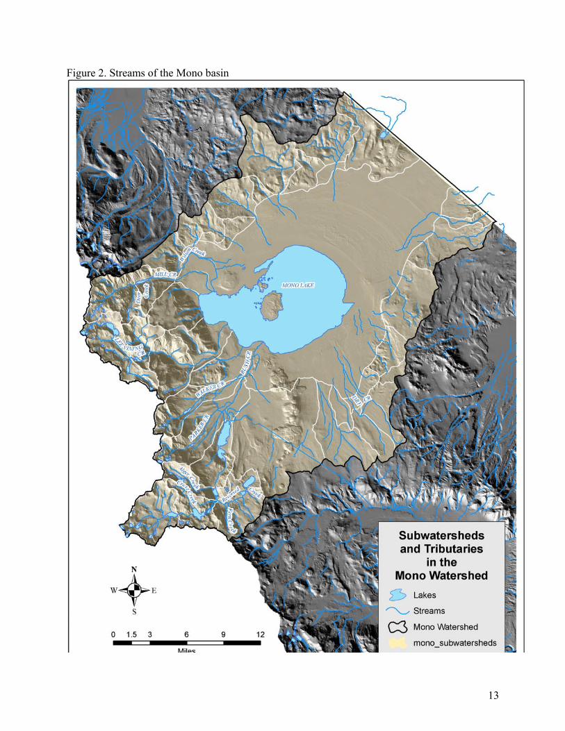
south of the divide between San Joaquin Mountain and Mount Lyell drain into the San Joaquin River. Within the watershed divide described above, the following named creeks are the principal streams in the Mono Basin (listed in a clockwise direction starting from the southwest near Mount Lyell): Rush Creek (with Parker Creek, Walker Creek and Reversed Creek tributaries) Lee Vining Creek (with Mine Creek, Glacier Creek, Gibbs Creek, and Warren Fork of Lee Vining Cr tributaries) Post Office Creek DeChambeau Creek Mill Creek Wilson Creek Bridgeport Creek Cottonwood Creek Dry Creek
13
Figure 2. Streams of the Mono basin

14
DESCRIPTIVE GEOGRAPHY Climate The climate of a region can be considered to be the "average" weather as well as the extremes over some period of time. We are usually limited to the historical period and then often only a few decades during which some systematic measurements of precipitation and temperature were made and recorded. The term "normal" is a convention that includes only the past 30 years. Similar to the warnings that accompany a financial investment prospectus, we should remember that past climate is no guarantee of future conditions. Nevertheless, recent climate is the best indicator we have of what to expect in the near future. Where inferences are available regarding prehistoric climate, such information is valuable to suggest the range of extremes that are possible in a given region. Most of the climatic data that is available for the Mono Basin was collected in association with the water management activities of the Los Angeles Department of Water and Power or Southern California Edison. NOAA Cooperative Observers have been monitoring precipitation and temperature in Lee Vining since 1988 (as well as wind since 1996) and at the Mono Inn from 1950-1988. The Sierra Nevada Aquatic Research Lab (SNARL) has maintained a weather station on the south tip of Paoha Island since 1991. A new data collection effort was getting started in the summer of 2006 in the alpine zone under the auspices of the Scripps Institute of Oceanography and the Desert Research Institute. Precipitation: Upper portions of the watershed can average 30 to 40 inches of annual precipitation, primarily as snow. Around the shore of Mono Lake, only 8 to 15 inches fall annually (diminishing from west to east) due to the rain shadow effect of the Sierra Nevada.

15
Precipitation declines rapidly from west (near the crest) to east (near Mono Lake). Precipitation is at a maximum in the upper elevation areas where measurements of the water equivalence of the snowpack at sites in upper Lee Vining Creek suggest that average annual precipitation is between 30 and 40 inches. Precipitation at the lower elevations near Mono Lake has been estimated for a few sites: lower DeChambeau Creek 13 inches, Conway Ranch 16 inches, and Black Butte 10 inches (Mann and Blevin, 1982; Vorster, 1985; Triad Engineering, 1988). One study estimated the average precipitation for the entire watershed was 12.4 inches per year (Los Angeles Department of Water and Power, 1984). This study estimated the average in the hill and mountain area to be 15.6 inches per year and the average on the valley floor (not including the lake) was 9.6 inches per year (Los Angeles Department of Water and Power, 1984). The great majority of precipitation in the Mono Basin falls as snow during the winter, except for small amounts from scattered thundershowers during the summer. The rain-snow elevation for most winter storms is below lake level, but sometimes can be up to 7,500 feet. On rare occasions, a warm midwinter storm may bring rainfall to elevations as high as 10,000 feet.
Precipitation gages have been located at a dozen (or more) sites in the Mono Basin periodically since 1926: Cain Ranch (1932-1982) ave 11.5" (LADWP, 1984) East Side Mono Lake (1976-1982) ave 5.7" (LADWP, 1984) Ellery Lake (1926-1982) ave 25.6" (LADWP, 1984); (1948-2005) ave 23.6" (WRCC, 2006) Ellery Lake (1973-2000) ave 26" Gem Lake (1926-1982) ave 21.8" (LADWP, 1984); (1948-2004) ave 19.9" (WRCC, 2006) Rush Creek Power House (1957-1979) ave 25.2" (LADWP, 1984) interesting and counterintuitive that Gem is lower than the powerhouse! Period of record, inaccurate measurements, or topographical weirdness? Lee Vining Ranger Station (1989-1993) ave 10" Lee Vining (Mono Lake Committee) (1988-2005) ave 14. 5" (WRCC, 2006) Conway Ranch 16" Mark Twain Camp (1950-1955) ave 6.8" (LADWP, 1984) Mono Lake (1951-1968) ave 12.5" (LADWP, 1984); (1950-1988) ave 14.0" (WRCC, 2006) Simis Ranch Bodie (1 mile outside the watershed boundary) (1964-2005) ave 13.09” (WRCC, 2006) (WRCC, 2006 = Western Regional Climate Center http://www.wrcc.dri.edu)

16
0
1
2
3
4
5
J F M A M J J A S O N D
Prec
ipita
tion
(inch
es)
Ellery Lake Lee Vining
Figure 3. Monthly mean precipitation (inches) at Ellery Lake and Lee Vining Ellery Lake 1948-2005; Lee Vining 1988-2005 Snowpack The hydrology of Mono Basin is dominated by winter accumulation of snow in the upper elevations of the Sierra Nevada and subsequent snowmelt runoff in the May-July period. Five snow courses (consistent points of measurement) have been measured in most, but not all, years since the late 1920s in the upper portions of the Lee Vining and Rush Creek watersheds. Snow courses Elevation period of record April 1 average April 1 max/min Gem Pass 10750 1931-2006 33.7 67.9(1983) / 7.8(1931) Tioga Pass 9800 1927-2006 26.8 56.6(1969) / 7.4(1977) Saddlebag Lake 9750 1927-2006 31.3 60.9(1969) / 9.9(1977) Ellery Lake 9600 1927-2006 29.0 57.2(1969) / 9.7(1977) Gem Lake 9150 1929-2005 30.0 60.3(1969) / 5.9(1976) Air temperature The station in the Mono Basin with the longest record of air temperature is at Cain Ranch, where the Los Angeles Department of Water and Power maintained a weather station from 1931 through the present (http://wsoweb.ladwp.com/Aqueduct/operations/monobasin.htm). The mean from 1931 through 1979 was 43ºF with a maximum of 94ºF and a minimum of -18ºF (Los Angeles Department of Water and Power, 1987). Two sites in and near Lee Vining have monitored air temperature for the periods 1950-88 and 1988-2005. The averages from these sites are remarkably close with an average maximum of about 62ºF and an average minimum of about 34ºF (data from Western Regional Climate Center

17
http://www.wrcc.dri.edu).
020406080
100
J F M A M J J A S O N DMonths
Maximum Minimum
Figure 4. Mean monthly maximum and minimum temperatures (ºF) from the Lee Vining station for the period 1988-2005. (data from Western Regional Climate Center http://www.wrcc.dri.edu) At Conway Ranch, summer temperatures range from the mid-40s to mid-80s, and winter temperatures range from 20ºF to 40ºF. The Conway Ranch area has a frost-free growing period of 45 to 130 days (Triad Engineering, 1988). Wind Winds are generated by storms moving across the Sierra Nevada from west to east, regional pressure differences, and differences in temperature across the elevation range of the basin. Wind speeds tend to be relatively low during the growing season. Wind speed was measured at Cain Ranch from 1961 through 1979. The average was 5.5 mph with a maximum of 60 mph (Los Angeles Department of Water and Power, 1987). This report mentions a minimum of 2.8 mph, but the time period for which that value is an average is not mentioned; the instantaneous minimum is certainly zero. Prevailing winds in the basin, as in the Sierra Nevada generally, are from the southwest. Almost all winter storms are accompanied by strong southwest winds. During summer, local winds usually arise each afternoon in response to temperature differences between the mountains and Mono Basin.

18
Evaporation Open-water evaporation from lakes above 9,000 feet has been estimated at about 20-25 inches per year, and is limited by ice cover. Open water evaporation from Mono Lake was estimated at about 40-45 inches per year in several studies through the 1960s and at 39 inches per year by the Los Angeles Department of Water and Power (1984). An estimate of 48 inches per year (apparently derived from a 1992 modeling study) was used in the EIR water balance (Jones and Stokes Associates, 1993a: Appendix A). Actual evapotranspiration at Conway Ranch was estimated at about 17-24 inches per year. Evaporation from June Lake has been estimated as 38 inches per year (or 940 acre-feet in volume, given the lake's surface area of about 297 acres) (California Department of Water Resources, 1981). Evaporation pans have been monitored at a few locations in the basin and provide an index of evaporation from small water bodies. Evaporation from a pan at Grant Lake totaled 43 inches, and average evaporation from a pan floating in Mono Lake from 1957 to 1959 was 74 inches (Lee, 1969). An evaporation pan was measured at Grant Lake between 1941 and 1985 during June, July, August, and September. The mean value over this period of record was 26 inches (Los Angeles Department of Water and Power, 1987). The reason for the large discrepancy between the two values at Grant Lake is unknown. Updated estimates of evaporation from Grant Lake have an average of 36 inches over the period from 1941 through 1994 (Greg Reis, personal communication, 2006). Two regional studies by Harding (1935 and 1965, cited by Lee, 1969) estimated evaporation in Mono Basin as 39 inches. Vorster (1985) estimated an average growing season evapotranspiration rate of 24 inches.
02468
1012
May Jun Jul Aug Sep Oct
Pan
Evap
orat
ion
(inch
es)
Grant Simis
Figure 5. Monthly averages of evaporation pan data from Grant Lake (floating pan 1942-69 and land pan 1968-69) and Simis Ranch (1980-83) (Vorster, 1985; Jones and Stokes Associates, 1993a: Appendix A). Climate Change Impacts

19
Under various global climate change scenarios, California is likely to see average annual temperatures rise by 4°F to 6°F in the next century, assuming actions are taken to reduce emissions of greenhouse gases. If no such changes are made, a “higher-emissions scenario” projects statewide temperature averages in California 7°F to 10.5°F higher. The range of figures comes from two models whose projections were summarized by the Union of Concerned Scientists in 2004. A theory suggests that high-elevation areas, such as the Mono basin, may warm more rapidly than regions as a whole. The Department of Water Resources estimates that a 3ºF temperature increase could mean an 11 percent decrease in annual statewide water supply. Under the coolest climate change projections, there could be a loss of about 5 million acre-feet/year in snowpack water statewide. In the Mono Basin, the snowpack would not be affected as much as in lower-elevation watersheds of the western slope because most of the heavy snowpack zone in the Mono Basin is at higher elevations (above 8,500 feet) that would still receive mostly snow except under severe warming scenarios. If more thunderstorms form over the land, due to more moisture in the warm air, that might increase the delivery of acids and pollutants to Sierra Nevada lakes. Cloudiness cuts both ways, however. Clouds can cool an area by blocking sunlight or keep it warm, functioning as a blanket in cold weather. There is uncertainty about how the effects of clouds might play out. Under either scenario, it is possible that the glaciers and permanent snowfields of the Mono basin will disappear at the end of summer by mid-century. The Dana Glacier has already shrunk dramatically since the late 1800s. Topography The Mono Basin spans the border between two major physiographic provinces—the Sierra Nevada and the Great Basin. Elevations within the Mono Basin range from 13,114 at Mount Lyell to 6,382 ft. (the approximate level of Mono Lake in August 2005). Stratigraphy reveals layers of glacial moraines (from 12 major glacial advances), volcanic pumice and ash, and sedimentary deposits from streams. Several terrain features have particular scientific and scenic value, including Bloody Canyon (a classic example of Sierran glaciation), the Mount Dana glacier, the Mono Craters and the islands in Mono Lake, Paoha and Negit.

20
Figure 6. Elevation bands

21
Geology and soils The Mono Basin is a sediment-filled depression created by faulting and tectonic downwarping. Granite and metamorphic rocks form the eastern Sierra Nevada escarpment to the west. The northern, eastern, and southern edges of the basin are volcanic formations: the Bodie Hills, Anchorite Hills, Cowtrack and Glass mountains, and Mono Craters. Glacial debris formed moraines and alluvial cobble deposits on slopes at the base of the Sierra Nevada (e.g., Bursik and Gillespie, 1993). Glacial erosion formed the broad, flat floors of Lundy, Lee Vining, Bloody, and Parker canyons. The major surface streams drain from the melting snowpack and alpine lakes high in the Sierra Nevada down across the glacial deposits to the sedimentary and volcanic layers of material that fill the basin. Soils on the west, southwest and northwest edges of the basin are derived mostly from the granitic core of the Sierra, along with sedimentary rocks uplifted with the Sierra. These are coarse soils that include rock fragments. The rest of the basin soils are from either volcanic deposits or lake sediments (ice-age Mono Lake has filled the basin as much as 700 feet higher than its present elevation; maximum elevation of Lake Russell estimated to be about 7,140 feet). Below this elevation, much of the present topography, soils, and groundwater hydrology were influenced by ancestral Lake Russell. Black Point is formed by basalt. The Mono Craters, in contrast, are rhyolitic deposits from relatively recent volcanic activity that are highly permeable to water and infertile. As the Mono Lake level dropped, salts have accumulated in the more recent sediments, particularly on the gently sloping gradients of the north and east sides of the basin. Soils derived from these sediments tend to have high salt content. The western and southern shores, where the landscape rises more steeply, have not been as affected by the salinity and alkalinity (National Research Council, 1987). UPLAND VEGETATION Plant communities dominated by big sagebrush (Artemisia tridentata), bitterbrush (Purshia tridentata), and/or rabbitbrush (Chrysothamnus nauseosus, C. viscidiflorus) currently occupy over 50 percent of the Mono Basin. They lack diversity due to historic fire suppression and grazing pressure. Vegetation on hillsides above the west and north shores of Mono Lake is dominated by pinyon pine (Pinus monophylla) and sagebrush. At higher elevations of the Sierra Nevada, lodgepole pine (Pinus contorta spp. murrayana), curl-leaf mountain mahogany (Cercocarpus ledifolius), and aspen (Populus tremuloides) appear, depending on local water availability. Jeffrey pines (Pinus jeffreyi) are found east of the Mono Craters and on south-facing draws and hillsides of the eastern Sierra Nevada escarpment. There are also rocky areas with very little vegetation cover consisting of alpine herbs. Limber pine (Pinus flexilis), western white pine (Pinus monticola), and whitebark pine (Pinus albicaulis) are found in the higher elevations of the watershed.

22
Figure 7. General vegetation types of the Mono basin.

23

24

25

26

27

28
SPECIAL-STATUS PLANTS Six special-status plants are known to occur below the 7,000-foot elevation in Mono Basin: Mono buckwheat (Eriogonum ampullaceaum), Utah monkeyflower (Mimulus glabratus), Mono milk vetch (Astragulus monoensis var. monoensis), Mono Lake lupine (Lupinus duranii), Tonopah milk vetch (Astragulus pseudiodanthus), and Bodie Hills draba (Cusickiella quadricostata draba) (Natural Diversity Data Base 1991; Jones and Stokes Associates, 1993). None of these plants is known or expected to occur along the tributary streams. Mono buckwheat occurs at several locations around Mono Lake above the pre-diversion (before 1941) lake level of 6,417 feet: near DeChambeau Ponds, Goat Ranch Road, Kirkwood Spring, Sulfur Pond, and south of Simon's Spring. Populations occur near or below the pre-diversion lake level near Danburg Beach, DeChambeau Ponds, Warm Springs, Simon's Spring, and the mouth of Rush Creek. Utah monkeyflower has been reported from Mono Vista Spring and the site of the Old Marina north of Lee Vining. It may occur at additional freshwater springs on the west side of the lake. Both known sites are near or below the 1941 lake level. Mono milk vetch occurs in small valleys filled with pumice sand in the Mono-Inyo Craters area. All known populations in Mono Basin are several miles south of the lakeshore or tributary streams. Mono Lake lupine has nearly the same distribution and habitat as Mono milk vetch. The known population nearest to the lake or tributary streams is at Panum Crater. Tonopah milk vetch is scattered throughout the northeastern portion of Mono Basin between the Bodie Hills and Cowtrack Mountain. The mapped location nearest to Mono Lake is over four miles from the eastern lakeshore. Bodie Hills draba has been found on hillsides north of Black Point (above 7,200 feet). WILDFIRE HISTORY and RISK Fire is a natural disturbance feature of the landscape. Prior to the 20th century, the primary cause of fire was lightning, coinciding with summer thunderstorms. When ignited at higher elevations, the fires were typically not large. Lower elevations experience fewer lightning ignitions, but the shrublands have the potential to burn more extensively, and have in the past. The Kuzedika of the Mono Basin did not use fire to manage resources in plant communities as much as Native Americans on the west slopes of the Sierra Nevada. Fire suppression policies were instituted when the Mono Forest Reserve became part of the early National Forest System. Most of this unit later became the Inyo National Forest. With the near absence of wildfire in the past century, fuel loads in forest and shrublands far exceed natural levels. Therefore, modern fires are likely to be both intense and extensive.

29
In 2005, the Bureau of Land Management began a study of mechanical fuels reduction within pinyon pine stands in the Bodie Hills. Experimental plots were to be cleared of pinyon pine and other vegetation in various densities and patterns of slash disposal. An ecologically significant and unusual fire occurred in 1954 when much of the riparian vegetation of lower Lee Vining Creek burned. The microclimate and well-watered vegetation of riparian zones usually limits fire damage in those areas. However, the minimal flow releases to lower Lee Vining Creek after 1941 predisposed the area to risk of a catastrophic fire. Following the fire, the channel was much more susceptible to erosion without living plants and their roots to stabilize the channel. Extensive erosion occurred in 1967 and 1969 when snowmelt runoff overwhelmed the structures intended to store and divert the water.
Recent Wildfires in the Mono Basin Month-Year Name Area (acres) Agency 8-1989 French 44 BLM 7-1996 Tioga 13 USFS 5-1997 DeChambeau 42 USFS 12-1999 DeChambeau 11 USFS 5-2000 Azusa 28 USFS 5-2000 Azusa 671 USFS 8-2001 Crater 5589 USFS 4-2003 Lundy 739 BLM 9-2003 June 50 USFS 4-2005 Near Simons Springs 6 or 7 2006 June 10-2006 Tioga or LV Canyon

30
Figure 8. Map of major wildfires [watershed jpegs mono_fire_and_flood]

31
RIPARIAN AREAS and WETLANDS Riparian areas border the streams and springs of the Mono Basin. The principal riparian systems occur along the three major streams that enter Mono Lake: Mill Creek, Lee Vining Creek, and Rush Creek. Mill Creek enters in the northwestern corner of the western embayment of Mono Lake. Lee Vining Creek enters the western embayment of Mono Lake from the southwest. Rush Creek enters Mono Lake from the south. Walker and Parker creeks are tributaries to Rush Creek. Three other small, perennial tributary streams (Wilson, Post Office, and DeChambeau creeks) enter Mono Lake from the west. Springs and intermittent streams drain the volcanic and alkaline hills that surround the rest of Mono Lake. Several geothermal springs exist within the basin (Jones and Stokes Associates, 1993a). Before the major water diversions began in 1941, about 385 acres of land bordering Rush and Lee Vining creeks was covered by mature riparian forest, dominated by black cottonwood (Stine, 1993). A fire in October 1954 burned much of the former cottonwood forest along Lee Vining Creek below the town. The lowest reach of Mill Creek was routinely dewatered by diversions for irrigation between the 1890s and 1920, resulting in the loss of riparian woodland on the delta. Photos show that most of the riparian stand in the lower reaches had already been lost by 1929. A study of riparian vegetation of eastern Sierra streams (Taylor, 1982) showed that Mill Creek above Upper Thompson Ditch supported a well-developed aspen-dominated riparian community, while the mid-reach, between U.S. Highway 395 and the bottom of Mono City, supported declining stands of black cottonwood (Populus balsamifera ssp. trichocarpa) and Jeffrey pine (Pinus jeffreyi). Further downstream, the riparian vegetation continued to decline, in terms of total cover and diversity. Taylor (1982) described the lowest reach on LADWP land as nearly devoid of riparian species with the exception of a few stunted clumps of narrowleaf willow (Salix exigua). Only a small amount of vegetation had colonized the existing channels in that reach. Recent observations show continuing limited recolonization. Annual flows and removal of grazing since the mid-1980s increased water availability and allowed for reestablishment of some riparian vegetation in parts of lower Mill Creek. Much of the system of multiple channels remained dry due to reductions in natural flows. Non-native species, such as woolly mullein (Verbascum thapsus) and sweet clover (Melilotus sp.), sporadically occupy the Mill Creek floodplain. There are also lake-fringing wetlands around Mono Lake (Figure 9) and some of the higher-elevation lakes (Figure 10). Water that has flowed downslope through the soil and subsoil often comes to the surface at streambanks and lakeshores, creating wetland environments adjacent to the waterbodies. Before diversions, the Mono Lake shoreline supported about 615 acres of wetlands, including 260 acres of brackish lagoon and 356 acres of marsh, wet meadow, alkali meadow, and wetland scrub habitat (their relative extent could not be distinguished using historical aerial photographs [Stine, 1993]).

32
Figure 9. Lake-fringing wetlands. Source: Jones and Stokes (1993a)

33
Figure 10. Wetlands of the Mono basin [ESLT Mono Basin Overview]
More than 200 acres of lagoons were found along the shorelines of Mono Lake in the prediversion period. Most of the lagoons were east of Sulfur Springs. A 23-acre lagoon developed at the DeChambeau embayment in the late 1940s after the lake dropped five feet below the prediversion level of 6,417 feet (Stine, 1993). Irrigation at DeChambeau Ranch likely enhanced wetlands at the DeChambeau embayment, but relatively fresh groundwater does reach this site (Balance Hydrologics, 1993a). Irrigation also appears to have contributed to maintenance of a narrow band of wetlands at Bridgeport Creek (Jones and Stokes Associates, 1993a). Brackish marshlands are found below the Mono Lake County Park (near the mouth of DeChambeau Creek), at the Old Marina site (north of Lee Vining) and at Warm Springs, on the eastern shore of Mono Lake (Jones and Stokes Associates, 1993a). Some initial wetland mapping was done as part of the Lahontan / U.C. Santa Cruz project (Curry, 1996). Several large wetlands are identified in Figures 11 and 12, which were reproduced from that report and from the June Lake Area Plan Final Environmental Impact Report (Mono County Planning Department, 1991: page II-7, Figure 3). Much of the present June Lake Village area was once wetlands that have been drained and/or filled (Curry, 1996). The water table in the southwestern portion of the June Lake Village has been artificially lowered for at least 20 years, but drainage efforts in the central portion of the Village were less

34
successful and extensive fill was required to raise building sites above the seasonally saturated level (Curry, 1996). High water levels are still evident in spring and early summer in some parts of the Village as well as in the Down Canyon area.

35
Figure 11. Wetlands of the June Lake Loop. Source: Curry, 1996: Figure 11

36
Figure 12. Wetlands of the June Lake Loop. Source: Mono County, 1991: Figure 3

37
Figure 13. Wetlands of the June Lake Loop. Source: Mono County GIS

38
Figure 14. Wetlands of the June Lake Loop. Source: U.S. Fish and Wildlife Service data layer
Dry meadows were of limited extent under prediversion conditions, because the relatively steeper shoreline minimized the area exposed to springs and seeps. Many of the springs supporting wetlands were underwater and forming tufa. As part of the conditions and mitigation measures of a 10-unit condominium project in the Down Canyon area, a replacement wetland of about 4,400 square feet was to be constructed following project completion that disturbed more than 4,000 square feet of natural wetland. Reports on the function of the replacement wetland were to be filed with the Lahontan Regional Water Quality Control Board. Invasive plants are a threat to native riparian vegetation. Salt cedar (Tamarix spp.) has become common through the southwestern United States and moved north from the Owens Valley in the past fed decades. It is present but under control (because of an interagency effort) along the lower reaches of Rush and Lee Vining Creeks. Tamarix crowds out most beneficial riparian shrubs and trees and uses large amounts of water.

39
Soapwort (Saponaria officinalis), also known as Bouncing Bet, is established along portions of Lee Vining Creek and in certain areas of June Lake. Botanists have noticed its spread in recent years and have become concerned about its displacement of native vegetation. In 2006, a pilot project tested several methods of control, and is expected to continue in the future. Other invasive plants, such as woolly mullein, Russian thistle, cheatgrass, and Russian olive, also have implications for terrestrial and aquatic ecosystems. More than 20 invasive species were found in 174 riparian transects along Rush and Lee Vining Creeks in 2005 (McBain and Trush report on file at Mono Lake Committee). Rush Creek Subalpine and forest riparian zones occur along the higher-elevation tributaries of Rush Creek wherever there is sufficient soil to support vegetation. Subalpine meadows are found throughout the headwaters of Rush Creek. Small pockets of wetlands are present in many parts of the June Lake Loop. Several types of wetland areas were identified in the 1991 June Lake Area Plan. Marshlands are located on the south side of June Lake and Gull Lake and adjacent to Rush Creek where it enters Silver Lake. In the 1991 June Lake Area Plan, the Silver Lake meadow was designated as a "Natural Habitat Protection District" and was proposed for a future land exchange into public holdings. The largest areas of open-grass meadows are southwest of Gull Lake in the Rodeo Meadows area and between State Route 158 and Nevada Street south of Silver Lake. A riparian woodland - meadow is located along State Route 158 between the Reversed Creek outlet of Gull Lake and the eastern boundary of Silver Lake Pines Tract #2 (Mono County Planning Department, 1991). The riparian corridor between Silver Lake and Grant Lake looks basically intact but has been impacted by the road, campground, and extensive recreational use. One of the largest historic wetlands in the Mono Basin occupied the area now inundated by Grant Lake reservoir (Stine, et al., 1984). The dam that enlarged Grant Lake was completed in 1941, but little change occurred downstream until 1947 because of a series of wetter-than-average years. Following low flows from 1948-51, pines started dying downstream of U.S. Highway 395. Cottonwoods and willows declined above the narrows throughout the 1950s as releases from Grant Lake varied from year to year. Consistently low releases during the early 1960s caused a rapid loss of riparian vegetation, though some vegetation managed to survive on springflow in parts of the bottomlands. Without healthy riparian vegetation to armor the streambanks, floods in 1967 and 1969 severely scoured the channels and removed large amounts of vegetation and bed and bank material. Because Mono Lake had dropped 28 feet by this time, Rush Creek incised down through its bed to reach this lower lake level. The water table dropped along with the elevation of the stream, causing most remaining vegetation to die or become severely degraded as the stream was almost completely diverted through the 1970s. High runoff in 1980, 1982, and 1984 caused even more damage by increasing incision and, consequently, draining more groundwater from adjacent riparian habitats. Near its mouth, Rush Creek ultimately incised 30 feet below its former floodplain, and the new delta floodplain was considerably narrower. Most of the side channels parallel to the main channel were dry and blocked with debris. Instream fish habitat was diminished by a lack of pools, spawning gravels, and woody debris. The high flows in the 1980s returned trout to the creeks, however. California Trout, Inc., the

40
National Audubon Society, and the Mono Lake Committee sued LADWP for not complying with Fish and Game code sections 5937 and 5946 that require sufficient flows below dams to maintain fish populations in good condition. A legal decision in 1985 led to resumption of flows in Rush Creek (Hart 1996). Consistent streamflow and a 1991 grazing moratorium also allowed riparian vegetation to begin recovering. As of 1989, there were 135 acres of mature woody vegetation, 33 acres of newly establishing riparian vegetation, and 40 acres of meadows in the Rush Creek riparian zone, These areas represent a 50 percent loss of pre-diversion woody riparian vegetation and a 70 percent loss of pre-diversion meadowlands (Jones and Stokes Associates, 1993a). Restoration of the Rush Creek riparian zone has been under way for more than a decade. Although the initial response to riparian restoration has been very encouraging, riparian acreage and ecological values are not expected to return to prediversion conditions because the physical channel situation has been altered so much (Jones and Stokes Associates and Trihey & Associates, 1994). Parker Creek Before 1941, Parker Creek below Parker Lake was lined with meadows, watercress, and dense riparian vegetation near its confluence with Rush Creek. The Lee Vining Conduit crosses Parker Creek above the irrigated pasturelands of Cain Ranch, and diverted virtually all of the water in Parker Creek into the Los Angeles Aqueduct via Grant Lake between 1947 and 1990. Drying the stream below the conduit caused loss of riparian vegetation and aquatic habitat. Gravel was pushed into the dry channel by Caltrans, forming a feature known as "Parker Plug," which was removed in 1990, marking the beginning of stream restoration on Parker Creek. As of 1989, 49 acres of woody riparian vegetation remained along Parker Creek, mostly highly stressed willow scrub; nine acres less than pre-1941 conditions. There were also extensive rush-dominated meadows, and a total of 32 different species of birds, mammals, and reptiles (Jones and Stokes Associates, 1993a). In 1990, water flowed down Parker Creek again as a result of a court order. The State Water Resources Control Board (SWRCB) set minimum flows in 1994, and stream restoration began in 1990. Walker Creek Walker Creek below Walker Lake is lined with meadows, watercress, and near the confluence with Rush Creek, dense riparian vegetation. The Lee Vining Conduit crosses Walker Creek above the irrigated pasturelands of Cain Ranch, and since 1947 diverted virtually all of the water in Walker Creek into the Los Angeles Aqueduct via Grant Lake. This diversion dried up the stream below the conduit, causing a loss of riparian vegetation and aquatic habitat. As of 1989, there were 43 acres of woody riparian vegetation along Walker Creek, mostly highly stressed willow scrub; seven acres less than pre-1941 conditions. There were also extensive rush-dominated meadows, and a total of 29 different species of birds, mammals, and reptiles. Walker Creek began to be rewatered in 1990.

41
Bohler Creek Most of the water in Bohler Creek below the aqueduct road is diverted for pasture irrigation at the north end of Cain Ranch. The main channel and irrigation ditches support about the same amount of scattered mixed riparian and willow scrub as was present in 1940. Riparian vegetation is essentially absent in the Bohler Creek canyon east of U.S. Highway 395 (as it was in 1940), and the willow scrub near the mouth of the canyon appears to have about the same extent and condition as in 1940 (Jones and Stokes Associates, 1993a). Horse Creek Dense coyote willow scrub occurs along the main channel of Horse Creek (the northern of two ravines crossed by U.S. Highway 395) from about 1,000 feet above to about 100 feet below the highway. Scattered coyote willow and mountain rose extend another 1,800 feet downstream. Willow and rose also occur along some of the irrigation ditches and the historical main channel, which crosses the highway 1,000 feet south of the current main channel (Jones and Stokes Associates, 1993a). Lee Vining Creek In 1941, diversion of water from Lee Vining Creek into the Los Angeles Aqueduct began. The diversion dam is just upstream from the Lee Vining Ranger Station. After 1947, high runoff ceased and pasture irrigation ended, causing the stream to be virtually dry below the diversion dam. The canyon is narrow below the diversion dam to a point a half-mile below U.S. Highway 395, and this kept soils moist enough for riparian vegetation to survive. Below this point, vegetation declined rapidly, and was severely affected all the way to Mono Lake. In 1954, a fire consumed much of this dead and some live riparian vegetation. The stream was nearly or completely dewatered until a 1969 flood caused severe channel widening, migration, and incision. In 1986, continuous low flows were obtained with a court order, and modest recovery of riparian vegetation occurred in places. A grazing moratorium was instituted in 1991, allowing further recovery of vegetation. As of 1989, there were 60 acres of mature woody riparian vegetation (44 acres upstream of 0.5 miles below U.S. Highway 395), a loss of 50 percent of what existed before 1941 (Jones and Stokes Associates, 1993a). A series of restoration measures began in the early 1990s. The riparian zone of the reach of Lee Vining between the Southern California Edison powerhouse and the intake for the LADWP diversion was described in a California Department of Fish and Game report (Deinstadt, et al., 1997) as narrow with vegetation consisting of lodgepole pine, aspen, willow, grasses, and a few Jeffrey pine. The channel was judged to have an adequate amount of large woody debris (Deinstadt, et al., 1997). Numerous campgrounds exist in this reach. The Forest Service is considering removal of campsites from floodplain and streambank areas.

42
Post Office Creek
About 27 acres of willow scrub occur on the small Post Office Creek delta below the 1940 lake level of 6,417 feet. Above U.S. Highway 395, the creek supports a narrow but generally continuous strip of willow and cottonwood-willow vegetation. Willows and cottonwoods also grow at several small hillside seeps above the creek (Jones and Stokes Associates, 1993a). Mill Creek Mill Creek, the third largest stream in the Mono Basin, has a wide, continuous riparian corridor characterized by Jeffrey pines and quaking aspen in the upper reaches and (before stream diversions) a dense, multi-storied, cottonwood-dominated stand in the lower reaches. The Mill Creek bottomlands near Mono Lake were a seasonally wet complex of riparian forests, thickets, wet meadows, ponds and sinuous channels. The shrub vegetation in the delta was comprised of narrowleaf (Salix exigua) and Pacific willows (Salix lucida ssp. lasiandra), creek dogwood (Cornus nuttalliisericea) and interior rose (Rosa woodsii var. ultramontana) while, upstream of the delta, Pacific willow and creek dogwood dominated (USDA-Forest Service, 2003). Following diversions to the Lundy power plant and Conway Ranch, stands of black cottonwood and Jeffrey pines declined along the mid-reach, between U.S. Highway 395 and the lower boundary of Mono City. Similarly, the narrow riparian corridor diminished through the bottomlands approaching Mono Lake (USDA-Forest Service, 2003). Locally high groundwater levels have created small seasonal wetlands on Conway Ranch and Thompson Ranch Meadow, which are enhanced by irrigation based upon Mill Creek water rights held by Mono County and LADWP (USDA-Forest Service, 2003). Wilson Creek Pre-diversion vegetation along Wilson Creek was typical of other ephemeral desert creeks such as Bridgeport Creek. Willow shrubs grew near the headwaters and in the vicinity of springs; the lower reaches passed through sagebrush, rabbitbrush, and bitterbrush along a channel lacking significant riparian vegetation. At present, a narrow band of riparian vegetation, primarily narrow-leafed willow, follows Wilson Creek (USDA-Forest Service, 2003). Distribution of vegetation on the Conway Ranch is associated with the location of natural seeps and the long history of irrigation for grazing on the property. Much of the Conway Ranch property has been flood irrigated for at least 100 years, resulting in the presence of hydrophytic (water-loving) vegetation in some irrigated portions. Natural wetland portions, representing approximately 47 acres of this property, consist of several areas of wet meadow located both north and south of Wilson Creek and a narrow fringe of narrowleaf willow paralleling Wilson Creek (Jane Schmit NRCS, personal communication, 2001).

43
There is debate about where the natural channel of Wilson Creek was located downstream of Cemetery Road. There is evidence that under natural conditions, neither of the channels that now carry water had significant flow or riparian vegetation.
DeChambeau Creek DeChambeau Creek and various springs support extensive willow scrub thickets between U.S. Highway 395 and Mono Lake. About eight acres of willow scrub occur below the 1940 lake level of 6,417 feet. Native and non-native cottonwoods and poplars occur along the main channel and irrigation ditches almost to U.S. Highway 395. Intermittent to continuous willow scrub, cottonwood-willow, quaking aspen, and conifer-broadleaf habitats follow the stream above the highway (Jones and Stokes Associates, 1993a).
FISH and WILDLIFE FISH No fish existed in the streams of the Mono Basin when European settlers arrived. However, there is fossil evidence to indicate that prehistoric fish populations at one time existed in the Mono Basin. Fish planting began in the middle of the 19th century, when Lahontan cutthroat trout (Oncorhynchus clarki henshawi) were introduced to the streams, and an abundant fishery flourished by 1900 (Beak Consultants Incorporated, 1991). Brown (Salmo trutta), rainbow (Oncorhynchus mykiss), and eastern brook trout (Salvelinus fontinalis) were stocked in Rush Creek from Fern Creek and Mount Whitney State fish hatcheries in the early 1900s (Beak Consultants Incorporated, 1991). Above Grant Lake, golden trout (Oncorhynchus mykiss aguabonita) were planted in the 1920s and 1930s, and at some point threespine stickleback (Gasterosteus aculeatus) were introduced into the system along with steelhead trout (also
Summary of impairment of riparian areas within the Mono Basin Entire basin 60 percent of riparian corridors eliminated by water export Another 19 percent modified by streamflow regulation Rush Creek 500 acres of riparian habitat inundated by Grant and Waugh reservoirs 75 percent of riparian corridor below wilderness eliminated by diversion Lee Vining Cr 44 percent of riparian vegetation below wilderness eliminated by diversion another 55 percent altered by flow regulation Mill Creek 80 percent of riparian vegetation below wilderness eliminated by diversion source: Federal Energy Regulatory Commission, 1990, and citations within.

44
known as rainbow trout) from the Ventura River. An egg-collecting station was constructed on Lower Rush Creek in 1925 and operated through 1953. Eggs were shipped to the Mount Whitney Hatchery or the Hot Creek Hatchery (after it was opened in the late 1930s). The Fern Creek Hatchery between Silver Lake and Gull Lake produced approximately 1 million fish per year from 1928 to 1942. Rush Creek became renowned for its brown trout fishery. They were introduced in 1919, were well established by 1931, where 3/4 lb. to 2 lb. brown trout were common, and occasionally a 6 lb. fish was caught. During the Great Depression, trout from Rush Creek regularly supplemented the diets of local residents. In the 1940s, the California Department of Fish and Game monitored a trophy fishing area for brown trout about a mile upstream of Mono Lake, where trout in excess of three pounds were regularly caught (Heinrich, personal communication, 2005). Today, rainbow, brown, and eastern brook trout are found in most of the lakes and streams in the Mono Basin, with reproducing populations supplemented by hatchery plantings (Jones and Stokes Associates, 1993a). The California Department of Fish and Game conducted electro-fishing surveys of different reaches of Lee Vining Creek during the mid-1980s. The reaches above the LADWP intake supported standing crops of brown, brook, and rainbow trout of 20 to 100 lbs per acre (Deinstadt, et al., 1997). Surveys in 2000 found fish abundance was low and brook trout were more abundant than rainbow trout in the lower reach of Rush Creek. Both species were most abundant in autumn. Fish populations were also small upstream, but rainbow trout were slightly more abundant there than brook trout during both surveys. Spawning success was poor in this area of Rush Creek. Spawning habitat quality for these species may be degraded by high flows in spring (> 300 cfs) that scour incubating eggs from the substrate, and low autumn and winter flows (< 4 cfs) that allow harsh winter conditions to reduce survival rates of incubating eggs (Donald Sada research, 2000, reported via Mono Lake Committee research clearinghouse). Annual reports from LADWP provide more recent information on the recovery of the fishery. The California Department of Fish and Game stocks rainbow trout in both Lundy Lake and Mill Creek below Lundy Lake. There is a self-propagating population of brown trout between Deer Creek and the Mill Creek Return Ditch, and both brown trout and rainbow trout may be taken as far downstream as Cemetery Road. The Wilson Creek fish community is almost exclusively comprised of brown trout (Beak Consultants Incorporated, 1986). Fish densities range from 103 to 370 fish per acre (17 to 52 pounds per acre by weight), and few fish exceed 8 inches in length. Small size of fish and low fish biomass suggest that Wilson Creek is a stream of low productivity, likely due to fluctuating water flow, relatively few nutrients, limited cover from riparian vegetation and a high sediment load from streambeds and banks altered by livestock (Triad Engineering, 1988). Also, there is little to no shade in the lower reach of Wilson Creek, below State Route 167, which allows surface water temperatures to rise, affecting temperature fluctuations along that reach. The reach also lacks undercut banks and streamside grasses, shrubs, and trees, providing little cover for aquatic species that reside in the creek (California Department of Fish and Game, 1998).

45
Mono County recently entered into an agreement with the Eastern Sierra Trout Foundation to manage and operate a fish-rearing facility on Conway Ranch The Foundation is entitled to priority usage of Mono County’s water right to rear trout of a variety of species, noting that this water use will be substantially non-consumptive. Flow rates needed to maintain current levels of fish rearing at the Mono County facility have been estimated at two to three cfs during the winter months, but a flow of approximately five cfs may be required to eliminate the freezing problems associated with the transport of water. If there is an expansion of the fish-rearing program as described in the MOU between the Sierra Trout Foundation and Mono County, those water needs would increase. Invasive Species The New Zealand mud snail is an invasive species occupying some streams of the eastern Sierra Nevada, such as the upper Owens River. The New Zealand mud snails quickly colonize streams and displace native invertebrate species. As of late 2004, no snails had been found in the Mono Basin. WILDLIFE Natural water flows support riparian habitat along all creeks and sustain a diversity of avian and other riparian dependent species. Populations of wildlife species such as mallards, teals, other ducks, geese, mountain lions, bobcats, coyotes, bighorn sheep, mule deer, pronghorn and sage grouse fluctuated due to natural changes affecting habitat and forage, and predator-prey relationships that included hunting pressure from the Native Americans. The small Native American population had a modest impact on wildlife species that inhabited the area. Over 150 years have passed since Europeans arrived in the Mono Basin in 1852. Impacts through development of lands and water resources, first for agricultural and mining purposes, and later for residential and recreational uses have altered wildlife habitats throughout the basin. Of the several wildlife species that use these habitats for foraging, nesting, or cover, some are threatened or endangered or are of special concern. These species include the willow flycatcher (Empidonax traillii), peregrine falcon (Falco peregrinus), bald eagle (Haliaeetus leucocephalus), osprey (Pandion haliaetus), yellow warbler (Dendronica petechia), mountain beaver (Aplodontia rufa), Inyo shrew (Sorex tenellus), and sage grouse (Centrocercus urophasianus) (USDA Forest Service, 1989; California Department of Fish and Game, 1990). Wildlife surveys suggest that riparian willow scrub habitats throughout the Mono Basin provide high-quality nesting, escape, feeding, and resting cover for a large diversity of resident and migrant birds and other wildlife; only cottonwood-willow forests supported more species. However, riparian habitats vary greatly in their overall condition and attractiveness to wildlife. Width and continuity increase their wildlife value, while human disturbance decreases it. Riparian habitats that are narrow and fragmented (e.g., Mill Creek bottomlands and Wilson Creek below State Route 167) do not appear to offer a high-quality movement corridor, especially for species with low dispersal capabilities such as most small mammals and reptiles.

46
Willow scrub habitats near the mouth of Mill and Wilson creeks support less than one-third of the wildlife species that were observed in similar willow scrub habitats on tributary streams such as Lee Vining and Rush creeks (18 species compared to 64 species, respectively). The relatively low wildlife diversity of lakeshore willow scrub habitats could be related to their isolation from riparian forests that are present along the tributary streams. The saturated soils associated with lakeshore willow scrub habitats also make them unsuitable for ground-dwelling species such as most small mammals and reptiles (Beedy, 1997). Wildlife values associated with continuous, tall, cottonwood-willow forests along restored reaches of mid- and lower Mill Creek are superior to those presently associated with the narrow and discontinuous stands of willow scrub vegetation on Wilson Creek. A Jones and Stokes Associates (1991) survey of birds, mammals, reptiles, and amphibians in riparian and wetland habitats indicated that multistoried, cottonwood-willow habitats supported more wildlife species (68) than any other riparian or wetland habitat type in the Mono Basin. This habitat is important to wildlife because it offers a tall canopy and a dense shrub and herbaceous understory that meets the habitat requirements of a high diversity of riparian wildlife species. Long-distance migrant birds depend on riparian habitats as they travel through the arid Great Basin. Mule deer (Odocoileus hemionus) are the most prominent big game species of the eastern Sierra Nevada. The Mono Lake mule deer herd, estimated at about 4,000 to 5,000 animals (Mono County Planning Department, 1991), winters in western Nevada and summers at high elevations on both the eastern and western slopes of the Sierra Nevada. This herd is considered relatively stable and not subject to short-term threats (Ferranto, 2006). Pronghorn (Antilocapra americana) were abundant in the Mono Basin prior to the 1880s; however, pressures of hunting, livestock-induced range degradation, and increased settlement resulted in their extirpation from the basin. Several reintroductions of pronghorn have since reestablished a herd that winters in Nevada and summers primarily in the Bodie Hills, although a small number occasionally wanders to the north shore of Mono Lake. Sightings have been made at DeChambeau Ranch and Conway Ranch. The peregrine falcon and bald eagle, both federally listed as endangered in California, are occasionally sighted within the Mono Lake watershed. It is currently unknown if there are any other listed species in the area due to lack of current survey data. Small numbers of bald eagles nest along the June Lake Loop and are periodically sighted along the shore of Mono Lake and DeChambeau Ranch; they winter near DeChambeau Ponds. While not common, peregrine falcon sightings occur irregularly on the shores of Mono Lake and at the DeChambeau Ponds. Mono Basin area sage grouse are considered a subpopulation of greater sage grouse (Centrocercus urophasianus). A petition for listing the Mono Basin area sage grouse as threatened or endangered was filed in November 2005 (Stanford Law School Environmental Law Clinic, 2005) and denied in late 2006. The birds are found throughout the Mono Basin. Suitable habitat consists of large expanses of sagebrush range with an interspersion of small meadows. Overgrazing of meadows and sagebrush range, over-hunting of the grouse, and human disturbance at leks have contributed to a depletion of habitat and abundance. Regular sightings occur near Thompson Ranch and on Conway Ranch. Areas northwest of Grant Lake

47
and Crater Mountain are also high use areas. A group of 30-50 sage grouse historically used the Parker Creek meadow as a lekking site (Banta, personal communication, 2005). Among the special-interest species known to occur within the Mono Basin include the Apache silverspot butterfly (Speyeria nokomis apacheana), large satyr butterfly (), and Mono checkerspot butterfly (Euphydryas editha monoensis), which occupy the wet meadow systems. Some of these species have critical needs for specific vegetation types for successful breeding within the riparian areas. The Mono Basin hosts a significant interior population of nesting snowy plovers found mainly on the exposed alkali flats of the northeast and east shore. The interior population is listed as a California State Species of Special Concern (3rd Priority). The remoteness of this colony away from well-known access points to the lakeshore has been enough to isolate these birds from the potential disturbance by visitors. A fence was constructed by the Bureau of Land Management in the early 1980s above the 1941 shoreline from a point above the north shore to a point above the southeast shore. Since revegetation of the recessional lands in this region is a slow process, the fence was constructed specifically to keep cattle from straying onto these sensitive recessional lands, preventing further impact on the limited vegetation growing here. An additional benefit of this fence is deterring off-road vehicles from venturing onto the alkali flats in this area. Yosemite toad (Bufo canorus) and mountain yellow-legged frog (Rana muscosa) have been observed in the upper reaches of Mono Basin drainages. Little is known of their habitat ranges in the Mono Basin, as suitable habitat for frogs and toads has not yet been surveyed. Reliable accounts from a century ago indicate that frogs were abundant in the high country. Known riparian species within riparian habitat include: Nuttall’s cottontail (Sylvilagus nuttallii), montane vole (Microtus montanus), mountain beaver (Aplodontia rufa), red-winged blackbird (Agelaius phoeniceus), song sparrow (Melospiza melodia), waterfowl, northern goshawk (Accipiter gentilis), osprey and red-tailed hawk (Buteo jamicensus), Sierra Nevada mountain beaver, mink (Mustela vison), willow flycatcher, Yosemite toad, and mountain yellow-legged frog. Beaver (Castor canadensis) were introduced along Mill Creek by the Department of Fish and Game in the 1950s. The population thrives above Lundy Reservoir for nearly the entire length of upper Lundy Canyon. Indications of beaver were found along DeChambeau Creek a few years ago, and in early 2006 a dead beaver was found along the shore of Mono Lake between Old Marina and Lee Vining Creek. In his travels through Mono Basin, Fisher (1902) made incidental observations of wildlife in meadows and willow thickets near the current Cain Ranch. He noted that the willow-lined streams flowing down Bloody Canyon and neighboring areas formed "natural highways" for wildlife moving between montane areas and the lowlands of the eastern slope. They were also, he noted, inviting stopover points for migrating birds through the arid Great Basin. In his surveys of riparian corridors, he observed house wrens, yellow-rumped warblers, MacGillivray's warblers, western tanagers, and whitecrowned sparrows (Fisher 1902). Dixon

48
(1916) and Grinnell (1915) surveyed willow and cottonwood thickets and boggy meadows along lower Rush Creek and observed a diversity of nesting and migratory bird species in this vicinity, including great horned owls, long-eared owls, house wrens, black-headed grosbeaks, Wilson's warblers, MacGillivray's warblers, yellow warblers, common yellowthroats, American robins, warbling vireos, song sparrows, red-winged blackbirds, and willow flycatchers. These are the same species that continue to visit Mono Basin today, although long-eared owls, yellow warblers, and willow flycatchers have declined substantially in recent decades. Willow flycatchers, a California state endangered species, have been observed in areas of riparian willow scrub on state recessional lands though no nests have been found. Willow flycatchers in the Mono Basin are being banded and monitored by scientists from Point Reyes Bird Observatory. The first nests in recent history were found in 2001 in riparian willow habitat upstream from recessional lands along Rush Creek (McCreedy and Heath, 2004). One long-term resident described the land near the mouth of Rush Creek as a "paradise where the vegetation was lush and green and the wildlife was abundant." According to her, it was dominated by aspens, cottonwoods, and Jeffrey pines. Her grandfather hunted wild game, principally rabbits, deer, ducks, and geese. Mallards and teals were especially abundant in the ponds and marshes of Rush Creek bottomlands. Another resident recalled the presence of large riparian trees, mostly cottonwoods, large flocks of ducks at the mouth of the creek, and abundant waterfowl and other wildlife farther upstream. Other historical observers recalled that dense riparian vegetation in the bottomlands supported abundant wildlife, including ducks, geese, deer, mountain lions, bobcats, and coyotes. Many more deer browsing and resting in the sage scrub upland used the creek as a source of water (Jones and Stokes Associates, 1993a). Grinnell (1915) and Taylor (1915) surveyed the aspen and conifer forests of upper Lee Vining Creek canyon in September 1915. There they observed northern flickers, American robins, mountain bluebirds, Townsend's solitaires, ruby-crowned kinglets, mountain chickadees, whitebreasted nuthatches, red-breasted nuthatches, Steller's jays, Clark's nutcrackers, brown creepers, yellowrumped warblers, MacGillivray's warblers, pine siskins, lazuli buntings, fox sparrows, song sparrows, white-crowned sparrows, and dark-eyed juncos. They noted broad stands of lush riparian vegetation along the length of the creek, describing it as a continuous corridor for wildlife species moving between the montane forests and the shores of Mono Lake (Grinnell, 1915; Taylor, 1915; Jones and Stokes Associates, 1993a). HUMAN HISTORY and LAND USE The North Mono Basin is the ancestral home to the Mono Lake Piute (or Kuzedika Piute) Indians and has been occupied continuously for the last 10,000 years. The population and geographical distribution of the native people of the Mono Basin is not known, but they survived upon the natural resources of the basin and traded surpluses with people to the west. Following the discovery of gold and silver in the 1860s, there was a sudden influx of

49
EuroAmericans into the Mono Basin and surrounding areas and towns emerged in Lundy Canyon and Rattlesnake Gulch. Logging deprived the Kudezika Piute of pine nuts from pinyon pines and caterpillars from Jeffrey pines; sheep grazing damaged the meadows that were the source of seeds, roots, and bulbs; hunting reduced the antelope, bighorn sheep, and sage grouse (Gaines, 1989). Bodie, Dogtown, and Aurora were significant population centers outside, but near, the Mono Basin watershed during the last half of the 19th century. Farms and ranches in the basin supplied food to these gold-mining communities. Irrigation ditches were developed at that time to bring water from creeks to pastures and farm fields. Between the 1880s and early 1900s, about 100 families utilized nearly all lands in the basin that could be farmed or grazed and diverted water from Mill, Lee Vining, Parker, Walker, and Rush creeks for irrigation (Lane, et al., 1975). Several irrigation ditch companies also served the basin's farms during this period. By 1920, most of the water rights were owned by the Cain Irrigation Company and the Southern Sierra Power Company. In the early 1930s, the City of Los Angeles purchased much of the private land in the Mono Basin, acquired preexisting water rights from the Cain Irrigation Company and Southern Sierra Power Company, and obtained new appropriative rights to Mill, Lee Vining, Parker, Walker, and Rush creeks with a combined discharge of 200 cfs (Lane, et al., 1975). Historical timeline (USDA-Forest Service, 1996; Kondolf and Vorster, 1992; Patera, 2000; Calhoun, 1984; Fletcher, 1987; DeDecker, 1993; Hart, 1996; Lee Vining High School, 2005; Mono Basin Historical Society, various issues) 1850-1880 Monoville built in 1859, LeRoy Vining operated a sawmill in Lee Vining canyon in 1860s, Bennettville -- Tioga Mining District, first claims at Lundy in 1879, rush at Lundy began in 1880 1880-1900 Extensive farming and logging to support mines in Lundy, Monoville, Bodie, and Aurora, avalanche at Lundy mining camp in 1882, boom years at Lundy 1880-1884 1900-1910 Consolidation of water rights for irrigation and hydroelectric generation 1910-1930 Service businesses expanded in Lee Vining, school built, Poole power plant built, Lee Vining electrified, Tioga Pass road completed to Lee Vining in 1910, Grant Lake dammed in 1915 and enlarged in 1925, dams constructed at Agnew, Gem, and Waugh lakes, avalanches destroyed Lundy and Jordan power plants in March 1911, Mono Inn built in 1922, Mono Lake reaches historic high level in 1919 1930-1940 Los Angeles becomes a major economic force in the Mono Basin, private lands purchased by LADWP, water rights acquired by LADWP, construction of Mono Tunnel and stream diversion works, population of Lee Vining about 300, highway 395 was paved in 1932, initial development of June Lake Village and surrounding areas began in the 1930s 1940-1950 Grant Lake further enlarged in 1940, water export began in 1941, pumice mine began operation

50
1950-1960 Aggregate mining along Lee Vining Creek, 1954 fire burned Lee Vining Creek riparian corridor, Use of snowplow technology increases number of year-round residents 1960-1970 Lee Vining High School built, June Mountain Ski Area completed in 1960, Lee Vining Canyon portion of Tioga Pass road rebuilt from 1965-1970, Mono City developed, massive incision of lower Rush Creek during high flows of 1967 and 1969, export capacity increased with completion of second barrel of aqueduct to Los Angeles 1970-1980 More development of Mono City, Mono Lake Committee formed, area plan for June Lake adopted in 1974, Mono Lake reached a level low enough that islands with nesting gulls became connected to shore in 1977 1980-1990 Mono Lake Tufa State Reserve created in 1981, Mono Lake reached historic low level in 1982, Mono Basin National Forest Scenic Area created in 1984, several lawsuits regarding Mono Lake and tributary streams were settled resulting in minimum flows for Rush and Lee Vining Creeks 1990-2000 Rewatering of Parker and Walker creeks began in 1990; State Water Resources Control Board issued decision D-1631 in 1994, amending LADWP’s water diversion licenses; Stream and Waterfowl Habitat Restoration orders issued in 1998, Conway Ranch acquired by Trust for Public Land and subsequently transferred to Mono County 2000-2006 Stream restoration work continues, U.S. Highway 395 widened to four lanes south of Lee Vining in 2000, grazing and irrigation removed from most LADWP lands because of Sierra Nevada Bighorn Sheep ESA listing, BLM Fire Station built at the mouth of Lundy Canyon Land use Agriculture Agriculture was the most extensive land use in the Mono Basin and relied on water diverted from the creeks on the west side of the basin. By the 1890s, perhaps 4,000 acres were irrigated for both crops and pasture (Vorster, 1985). The Cain Irrigation District and Rush Creek Mutual Ditch Company provided water to farmers in the early 20th century. By the 1920s, up to 11,000 acre-feet of water was diverted from lower Lee Vining Creek to irrigate lands both north and south of the creek. Chris Mattly grew alfalfa and wheat near the mouth of Lee Vining Creek. In the 1920s and 1930s, fields of potatoes and alfalfa occupied the present site of Lee Vining High School. Streamflow in Gibbs Creek and Horse Meadow was completely altered to supply an irrigation channel. The amount of land under irrigation probably peaked at about 11,000 acres in 1929 (Harding, 1962; cited by Vorster, 1985). As the City of Los Angeles acquired land and water rights in the 1930s, the amount of land under cultivation decreased. Changes in irrigation along Lee Vining and Rush creeks coincided with changes in water availability that resulted from LADWP's diversions. Pasture irrigation along Lee Vining Creek above and below the County Road ceased when streamflows declined in the early or mid-1940s. Irrigation in the Rush Creek bottomlands via Indian Ditch and diversions for artificial ponds near the mouth of Rush Creek also ended about this time. Most of the meadows and

51
wetlands maintained by this irrigation disappeared during the 1950s and 1960s. About half of the "lower meadows" (farthest from The Narrows) in the Rush Creek bottomlands have continued to be sustained by groundwater until the present. Changes in pasture irrigation in Pumice Valley also produced changes in water availability. Ditch flows declined by 70 percent to 80 percent after 1947 due to diversions by LADWP. When irrigation in Pumice Valley declined, flows from springs on the east side of the Rush Creek bottomlands also declined. This decrease in flow caused degradation of meadows, wetlands, and willow scrub thickets at the springs on the east side of the bottomlands. The lowest reach of Mill Creek was routinely dewatered by diversions for irrigation between the 1890s and 1920, resulting in the loss of riparian woodland on the delta. Photos show that most of the riparian stand in the lower reaches had already been lost by 1929. Irrigation of pastures and meadows on Thompson Ranch and the DeChambeau Ranch has been applied at a rate of approximately 2 acre-feet per acre per season for maintenance of grasses and trees at those historic sites (USDA-Forest Service, 2003). Sheep began grazing in the riparian corridors and surrounding uplands of Rush, Parker, Walker, and Lee Vining creeks as early as the 1860s. Overgrazing exacerbated the decline in habitat quality, accelerated the loss of meadow and woody riparian acreage, and retarded the recovery of vegetation after rewatering. Negative effects on pastures of the Mono Basin were noted as early as 1881 by geologist Israel Russell. LADWP ceased irrigation of highly porous soils with low forage yields in the 1960s, and by the mid-1980s, it was irrigating only about 2,000 acres near Cain Ranch, 200 acres in the northwest part of the basin, and about 150 acres in Horse Meadow and Lee Vining Canyon (Vorster, 1985). LADWP implemented a grazing moratorium in the riparian zones of Rush, Parker, Walker, and Lee Vining creeks in 1991, which is in effect until 2008. LADWP has no plans to resume grazing at this time. The result of the moratorium was a substantial increase in the cover and diversity of herbaceous and woody riparian vegetation where the vegetation was previously suppressed by sheep. Timber harvesting The Mono Basin was a major source of lumber and fuel wood for the mines near Bodie and Aurora. A five-ton steamer was brought from San Francisco in 1879 to tow barges filled with lumber from Lee Vining Canyon across Mono Lake (Hart, 1996). Apparently, there were so few trees remaining near Lee Vining in the 1920s that lumber had to be brought from Mammoth and Bodie to build the school. In the early 1880s, a railroad was constructed on the east shore of the lake to transport lumber from Mono Mills, on the southeast side, toward Bodie. The logging camp at Mono Mills operated intermittently until 1917 (Hart, 1996). The Inyo National Forest had a timber sale south of Mono Mills in 1997.
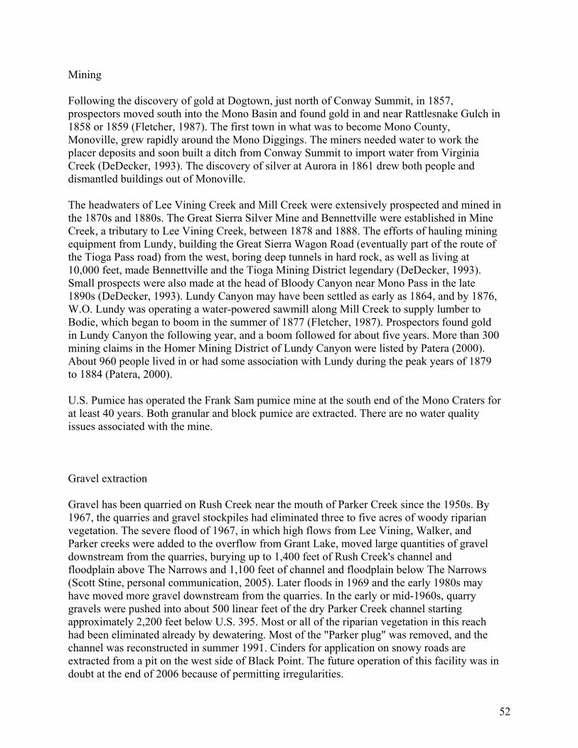
52
Mining Following the discovery of gold at Dogtown, just north of Conway Summit, in 1857, prospectors moved south into the Mono Basin and found gold in and near Rattlesnake Gulch in 1858 or 1859 (Fletcher, 1987). The first town in what was to become Mono County, Monoville, grew rapidly around the Mono Diggings. The miners needed water to work the placer deposits and soon built a ditch from Conway Summit to import water from Virginia Creek (DeDecker, 1993). The discovery of silver at Aurora in 1861 drew both people and dismantled buildings out of Monoville. The headwaters of Lee Vining Creek and Mill Creek were extensively prospected and mined in the 1870s and 1880s. The Great Sierra Silver Mine and Bennettville were established in Mine Creek, a tributary to Lee Vining Creek, between 1878 and 1888. The efforts of hauling mining equipment from Lundy, building the Great Sierra Wagon Road (eventually part of the route of the Tioga Pass road) from the west, boring deep tunnels in hard rock, as well as living at 10,000 feet, made Bennettville and the Tioga Mining District legendary (DeDecker, 1993). Small prospects were also made at the head of Bloody Canyon near Mono Pass in the late 1890s (DeDecker, 1993). Lundy Canyon may have been settled as early as 1864, and by 1876, W.O. Lundy was operating a water-powered sawmill along Mill Creek to supply lumber to Bodie, which began to boom in the summer of 1877 (Fletcher, 1987). Prospectors found gold in Lundy Canyon the following year, and a boom followed for about five years. More than 300 mining claims in the Homer Mining District of Lundy Canyon were listed by Patera (2000). About 960 people lived in or had some association with Lundy during the peak years of 1879 to 1884 (Patera, 2000). U.S. Pumice has operated the Frank Sam pumice mine at the south end of the Mono Craters for at least 40 years. Both granular and block pumice are extracted. There are no water quality issues associated with the mine. Gravel extraction Gravel has been quarried on Rush Creek near the mouth of Parker Creek since the 1950s. By 1967, the quarries and gravel stockpiles had eliminated three to five acres of woody riparian vegetation. The severe flood of 1967, in which high flows from Lee Vining, Walker, and Parker creeks were added to the overflow from Grant Lake, moved large quantities of gravel downstream from the quarries, burying up to 1,400 feet of Rush Creek's channel and floodplain above The Narrows and 1,100 feet of channel and floodplain below The Narrows (Scott Stine, personal communication, 2005). Later floods in 1969 and the early 1980s may have moved more gravel downstream from the quarries. In the early or mid-1960s, quarry gravels were pushed into about 500 linear feet of the dry Parker Creek channel starting approximately 2,200 feet below U.S. 395. Most or all of the riparian vegetation in this reach had been eliminated already by dewatering. Most of the "Parker plug" was removed, and the channel was reconstructed in summer 1991. Cinders for application on snowy roads are extracted from a pit on the west side of Black Point. The future operation of this facility was in doubt at the end of 2006 because of permitting irregularities.
53
Figure 15. Quarries for gravel, cinders, and pumice.

54
Roads Construction of the current U.S. Highway 395 during the 1930s removed an estimated 0.5 acre of woody riparian vegetation on Rush Creek, 0.2 acre on Parker Creek, 0.1 acre on Walker Creek, and 0.1 acre on Horse Creek. Construction of existing State Route 120 removed an estimated 0.2 acre of woody riparian vegetation on Lee Vining Creek and prevented water from entering an overflow channel on the east side of the creek. Approximately two acres of conifer-broadleaf forest that existed along the overflow channel in 1940 was no longer present 1989 (Jones and Stokes Associates, 1993a).

55
Figure 16. Major roads in the Mono basin.

56
Hydroelectric development Water from Mill Creek was diverted to generate hydroelectric power in the early years of the 20th century. The original powerhouse at the Jordan site, north of the Mill Creek divide and 0.5 mile south of Conway Ranch at the base of Copper Mountain, was destroyed by an avalanche in 1911 (Patera, 2000; Triad Engineering, 1988) [dated as 1905 in Stine (1995). In 1911, the Lundy Project was completed by the Southern Sierra Power Company (Perrault, 1995). Construction of a dam raised the natural outlet of Lundy Lake 37 feet to an elevation of 7,803 feet (Stine, 1995). Lundy reservoir has a surface area of 130 acres and a usable capacity of about 3,800 AF (Vorster, 1985; Perrault, 1995). The diversion to the Lundy powerhouse has a capacity of about 70 cfs. The Mill Creek plant was damaged, apparently by a landslide, in 1961 and was rebuilt by 1969. Southern California Edison assumed ownership and control of the hydroelectric facilities in 1962 (Vorster, 1997) as Federal Energy Regulatory Commission project 1390. A small hydroelectric project called the Paoha Project was denied a license to operate on the tailrace flow of the Lundy powerhouse in the 1980s. Regulation of the flows in Lee Vining Creek for hydroelectric generation began in 1921 (now FERC project 1388). Ellery, Tioga, and Saddlebag reservoirs in the headwaters of Lee Vining Creek have a combined storage capacity of 13,600 acre-feet. Much of the creek's flow is contained within a penstock between Ellery Lake (9,490 feet) and the Poole Powerhouse (7,840 feet). About 27,000 acre-feet of water passes through the powerhouse each year. Operations can reduce streamflows by 25 percent in snowmelt runoff months (May-July) and increase fall and winter base flows by 400 percent (Aquatic Systems Research, 1993). When SCE constructed its small diversion dam and powerhouse on Lee Vining Creek between the town of Lee Vining and the ranger station, an estimated 1.5-2.5 acres of woody riparian vegetation were removed from the diversion site, and an estimated two to three acres were removed from the powerhouse site. About one acre of riparian and meadow vegetation has become reestablished at the diversion site since its use as a forebay ceased Jones and Stokes Associates, 1993a); however, the Lee Vining Public Utilities District built a water tank on this site since then. Between 1916 and 1925, dams were constructed to enlarge Agnew and Gem lakes and at Rush Creek Meadows to form Waugh Lake to allow storage and regulation of water for the Rush Creek powerhouse near Silver Lake. Waugh, Gem, and Agnew reservoirs can store 4,980; 17,060; and 860 acre-feet, respectively, for Southern California Edison's FERC project 1389. Waugh is drained and sits unused from October to May each year. Residential development There are three communities within the Mono Basin: June Lake, Lee Vining, and Mono City. Private property is limited outside those communities. Lee Vining has a population of about 350 people, about 20 businesses along U.S. Highway 395, and occupies about 30 acres. Mono City is a community of approximately 100 residents near the junction of U.S. Highways 395 and State Route 167. A few houses are located at Conway Ranch, about a mile east of U.S. Highway 395. There are a few private residences along the west and northwest shore of Mono Lake. In Lundy Canyon, there are a few private residences and a summer-seasonal

57
fishermen’s resort. The communities of Lee Vining and June Lake have economies focused on travelers and tourism. The June Mountain Ski Area attracts winter visitors. These communities serve as centers for hiking, mountain biking, fishing, camping, and skiing. General policy for development in the June Lake loop area is specified in June Lake 2010: June Lake Area Plan (Mono County Planning Department, 1991). A large residential and resort development is planned in the "Rodeo Grounds" area, a 90-acre parcel just north of the June Mountain Ski Area (Perkins Design Associates and Triad Engineering, 2004). A critical aspect of the planning for this project was determination of the adequacy of the potential water supply. Recreation The primary recreation facility in the Mono Basin is the June Mountain Ski Area. During construction in the early 1970s, presumably there was extensive erosion and a sediment pulse into Reversed Creek and Silver Lake (Blodgett, 1996). The ski runs became vegetated within a few years, and sedimentation basins were built to keep sediment on-site. Under terms of the special-use permit with the Inyo National Forest, the ski area implemented an erosion-prevention plan in 1982 (Blodgett, 1996). There are 19 campgrounds within the Mono Basin. Most of them have a portion of their developed area within a riparian area. The roads, trails, compacted surfaces, and waste disposal cause some degradation of riparian habitat and add sediment and other contaminants to adjacent streams. Campgrounds Number of sites Aspen Grove 56 Big Bend 17 Cattleguard 16 Ellery Lake 12 Grant Lake Trailer Park 70 Gull Lake 11 Junction 13 June Lake 28 Lower Lee Vining 62 Lundy Canyon 51 Oh!Ridge 148 Pine Cliff Trailer Park 180 Reversed Creek 17 Saddlebag Lake 20 Sawmill Walk-In 12 Silver Lake 62 Tioga Lake 12 Upper Lee Vining I 33 Upper Lee Vining II 22

58
None of these campgrounds has an RV dump station in the immediate area. The Inyo National Forest has proposed to built a new RV sewage disposal station near the entrance to the Oh!Ridge campground. Other developed facilities such as picnic grounds, beaches, and parking areas for fishing are found at South Tufa, Silver Lake, Aerie Crag, June Lake Beach, and County Park. The use of off-road vehicles may have some localized impacts in riparian areas with nearby roads and unofficial OHV trails. Land ownership and interagency cooperation More than 90 percent of the Mono Basin is USDA-Forest Service, Bureau of Land Management, or Los Angeles Department of Water and Power land (Figure 17). Since 1981, the California Department of Parks and Recreation has also been involved, following the creation of the Mono Lake Tufa State Reserve. The state reserve consists of approximately 6,000 acres of the shoreline of Mono Lake including landscapes ranging from alkali flats to highly productive wetlands, and the bed and waters of the lake itself. The purpose of the reserve is to protect the tufa formations uncovered by the diversions and to protect the resources of the uncovered bed in a manner consistent with its designation as a state reserve. The Inyo National Forest administers the Mono Basin National Forest Scenic Area, established by Congress in 1984. A management plan for the Scenic Area includes some provisions for private property within the boundaries. Mono County and the USDA-Forest Service have different land-use restrictions, both of which must be met by private landowners.

59
Figure 17. Land ownership in the Mono basin

60
DESCRIPTIVE HYDROLOGY Runoff generation processes Most runoff is generated in spring and early summer from melt of the seasonal snow cover. Relatively little subsurface storage capacity exists in the thin layer of unconsolidated materials in the headwater areas, yet there does appear to be some capacity in alluvial and colluvial materials, most below about 7,500 feet. Therefore, the volume and timing of runoff depend on the quantity of water stored as snow and the timing of its melt. For example, approximately 81 percent of the annual runoff of Mill Creek has been attributed to snowmelt, occurring from April through September, and the remaining 19 percent of the annual streamflow occurs as base flow from October through March (Perrault, 1995). Although the annual hydrograph (daily volume of streamflow plotted against day of the water year [October to September]) has roughly the same shape each year, the volumes of snowmelt runoff can be quite different from year to year (Figure 18).
Figure 18. Example of annual streamflow pattern for Rush Creek over three years. Data, reconstructed natural flow, and graph from U.S. Geological Survey.

61
Water balance A water balance is a useful tool for understanding the various quantities of water involved in different parts of the hydrologic cycle within a particular watershed. Because of the water management operations and the legal conflicts over water rights in the Mono Basin, several water balance studies have been conducted in the past 30 years (e.g., Vorster, 1985; Los Angeles Department of Water and Power, 1985; Perrault, 1995; Jones and Stokes Associates, 1993] For example, a 1984 study by the Los Angeles Department of Water and Power accounted for water in the Mono Basin for the period 1941-76 over a total land 750 square miles and lake area of 66 square miles in acre-feet per year as follows: Inflow Direct precipitation Hill and mountain area 304,000 Valley fill area 157,000 Mono Lake 33,000 Imported water (Virginia Creek) 3,000 Total inflow 497,000 Outflow Exported water 65,000 Tunnel make outflow 5,000 Mono Lake evaporation 162,000 Valley Fill ET Grant Lake 1,000 Irrigation consumptive use 7,000 Residential consumptive use 1,000 Native vegetation 175,000 Hill and Mountain ET Lakes 2,000 Native vegetation 130,000 Total outflow 548,000 Change in storage Mono Lake -52,000 Grant Lake +1,000 Groundwater 0 Total change in storage -51,000 As a summary of this water balance, evaporation from the surface of Mono Lake accounted for about 33 percent of the precipitation, evapotranspiration from the land and other lakes of the basin accounted for about 64 percent of the precipitation, and exports to the Los Angeles aqueduct accounted for about 13 percent of the precipitation. The excess of outflow over inflow was made up from a loss in the water stored in Mono Lake. More recent (1994-1999) estimates of evaporation from Grant Lake have an average of 2,460 AF (Greg Reis, personal communication, 2006).

62
Water balances for lower Rush Creek were estimated for different historical periods as irrigation practices, hydroelectric generation, and diversions for export changed over time (Kondolf and Vorster, 1993). Streamflow averages and extremes A study by the Los Angeles Department of Water and Power (1984) calculated the average annual amount of measured runoff (Mill, DeChambeau, Lee Vining, Gibbs, Parker, Walker, and Rush creeks) within the basin between 1940 and 1976 to be 142,000 acre-feet. Other estimates of the average sum of annual measured streamflow include 150,000 acre-feet (Vorster, 1985) and 148,000 acre-feet (LADWP-90RY water balance model cited by Jones and Stokes Associates, 1993a: Appendix A). The 1984 LADWP study estimated that flow in small streams that are not measured was another 15,000 acre-feet for a total estimated surface inflow to Mono Lake of about 167,000 acre-feet. Another estimate of the ungaged inflow to Mono Lake is 35,000 acre-feet (Vorster, 1985). During the 1941-76 period, Rush Creek averaged 79 cfs or 57,400 acre-feet per year, Lee Vining Creek averaged 64 cfs or 46,600 acre-feet per year, and DeChambeau Creek (the smallest measured stream) averaged one cfs or about 800 acre-feet per year (Los Angeles Department of Water and Power, 1984). Another estimate of the long-term average flow of Rush Creek above Grant Lake (USGS gage 10287400) is 82 cfs or 59,000 acre-feet between 1938 and 1994 (Blodgett, 1996). An estimate of the long-term average streamflow of Reversed Creek below Gull Lake is 1.4 cfs or 1,000 acre-feet per year (Blodgett, 1996; Mono County, 1993). Snow Creek had an average flow of about 1 cfs from 1985 through 1987. Between 1935 and 1979, the average annual flow in Lee Vining Creek (USGS gage 10287900) was 47,000 acre-feet. Annual volumes during this period ranged between 18,000 (in 1977) and 92,000 acre-feet (in 1938). The annual peak flow varied from 140 cfs in 1959 to 580 cfs in 1967. Discharge during the low-flow portions of the year (usually late autumn and early winter) typically varied between 0 and 3 cfs. The average annual flow of Mill Creek just below Lundy Lake is about 21,000 to 22,000 acre-feet or 29 cfs. The annual volume at this site has ranged from 8,700 to 40,000 acre-feet. Base flow has generally been between 10 and 18 cfs, but flow has ceased entirely in very dry years (USDA-Forest Service, 2003).

63
Average annual runoff and watershed area for gauged streams in the Mono Basin Stream Area at Average runoff Average runoff gage (ac) volume (acre-feet) depth (inches) Rush Creek 33,280 59,800 22 South and East Parker Creeks 1,856 1,200 8 Parker Creek 4,032 9,100 27 Walker Creek 4,992 5,400 13 Lee Vining Creek 22,400 49,200 26 Dechambeau Creek 1,600 900 7 Mill Creek 11,520 21,500 22 Data from Jones and Stokes Associates, 1993: Tables 2-4 and 3A-1. Floods and droughts Floods that are significant from a watershed management perspective occurred in 1967 and 1969 in Rush and Lee Vining creeks, which lacked bed and bank stability following more than 25 years of minimal flows. The snowmelt floods of the late 1960s greatly eroded the channels and moved enormous amounts of sediment. In the early 1990s, a study by the U.S. Army Corps of Engineers (1993) found that there was little or no risk of significant flooding along Reversed Creek in the June Lake area. Downstream at Silver Lake, water has risen into the adjoining wetland areas during major runoff events such as in 1967 and 1997. Two serious multi-year droughts occurred in the Mono Basin in the past century. Between 1923 and 1935, streamflow in the basin averaged about 74 percent of the 1941-89 average with several years of near-average runoff (Jones and Stokes Associates, 1993a: Appendix H). Within this extended period, streamflow between 1928 and 1934 averaged about 65 percent of the long-term average. An even-drier period occurred between 1987 and 1992 when annual streamflow averaged only 60 percent of the 1941-89 average (Jones and Stokes Associates, 1993a: Appendix H). Streamflow was also much below average in 1976 and 1977. Evidence of severe and persistent drought has been found in the West Walker River channel, indicating periods of 140 to 220 years with very little precipitation (Stine, 1994). Dozens of Jeffrey Pine stumps are rooted in the main channel of the Walker River Canyon. These trees could only survive in that location if streamflow was so low that the roots of the trees were not submerged for more than a few weeks each year (Stine, 1994). The age of the trees in the West Walker River corresponds to the age of other old stumps found in Tenaya Lake and near Mono

64
Lake, suggesting that dry conditions during the same periods allowed establishment of trees in other locations in the region (Stine, 1994). Recent observations have found large trees rooted deep within Fallen Leaf Lake near Lake Tahoe, probably dating to the same period (Kleppe, 2005). A study published in 1922 also alluded to a drought in California’s pre-history lasting more than a century (Clifford, 1994). The source of that account may have been lore passed between generations of Native Americans. Lakes The shoreline of Grant Lake reservoir is composed of coarse sands, gravels, and cobbles. The water surface rarely reaches the highest elevation, coinciding with the dam spillway. Records of the surface elevation of Grant Lake reservoir from 1970 to 1989 show a pattern of low water elevation in spring, an abrupt rise in early summer, followed by a slower decline. The average annual drawdown has been 32 feet. A management plan was prepared for Grant Lake as part of the Environmental Impact Report work done in the early 1990s. During the low reservoir levels of 2003-2005, there was conflict between recreational interests and the water management practices over the optimum lake level. The State Water Resources Control Board, in adopting D1631 in 1994, acknowledged that there would be significant unavoidable impacts to recreation: “The need to establish the fishery protection flows and water diversion criteria to protect other public trust resources are overriding considerations which justify adoption of this decision despite potential adverse impacts on recreation at Crowley Lake and Grant Lake.” A study of water quality in the June Lake loop area (Brown, 1979) reported that June Lake has a total water volume of about 18,000 acre-feet, surface area of about 298 acres, and a maximum depth of about 130 feet. Gull Lake has a total volume of about 2,570 acre-feet, surface area of about 67 acres, and a maximum depth of about 65 feet. Silver Lake has a total volume of about 3,300 acre-feet, surface area of about 112 acres, and a maximum depth of about 60 feet. Lundy Reservoir can store about 3,800 acre-feet of water (Vorster, 1985; Perrault, 1995).

65
Figure 19. There are many lakes in the headwater areas of the tributaries to Mono Lake.

66
Groundwater The uppermost aquifer in most of the Mono Basin is a discontinuous layer of stream sediments, colluvial material, and wind-blown deposits lying above the less permeable lake bed deposits (Los Angeles Department of Water and Power, 1984). The underlying layer of low permeability, which is generally found at depths between 10-20 and 30-40 feet below the present surface, was deposited in Lake Russell during the Tioga glacial advance and is described by Lajoie (1984). Beneath that layer (generally more than 30 feet below the present surface) is a relatively permeable layer about 50-60 feet thick that consists of gravelly sand deposited between the Tahoe and Tioga glacial stages (Los Angeles Department of Water and Power, 1984). This layer is the main water-bearing layer that serves as an aquifer recharging Mono Lake. One area where these layers are absent is between the Lee Vining Creek delta and the Mill Creek / Mono City area. Granitic and metamorphic bedrock is present in that region of the basin (Los Angeles Department of Water and Power, 1984). Confined aquifers are recharged along the margin of the basin floor through fractures in the surrounding igneous rocks. Discharge from the aquifers occurs along localized faults as discrete springs and by upward leakage through semi-confining lacustrine sediments (Lee, 1969). Total groundwater discharge into Mono Lake has been estimated to be between 20,000 and 40,000 acre-feet per year (Los Angeles Department of Water and Power, 1984). Details about groundwater conditions in the north Mono Basin may be found in USDA-Forest Service (2003) report on the area. Springs are found throughout the Mono Basin, and hydrologic characteristics of some of them have been described. Mono Vista springs discharge about 5 to 42 l/s [0.18 to 1.5 cfs] (Lee, 1969). Black Rock Point hot spring, which is four miles away from Conway Ranch, flows at 33 gallons per minute (Kleinfelder and Associates, 1983). Diversions and storage Between 1941 and 1980, the Los Angeles Department of Water and Power diverted as much as 134,600 acre-feet and as little as 15 acre-feet. After the completion of the second aqueduct, LADWP diverted more than 100,000 acre-feet annually, except during 1976-77 drought. (Hashimoto and Qasi, 1981). Diversions were halted by court order from 1989 to 1994. Starting in 1995, diversions up to 16,000 acre-feet per year resumed under Decision 1631. Details on diversions from individual streams are found in the subwatershed section. The volume of water diverted from Virginia Creek into the Mono Basin at Conway Ranch has been up to 2,500 acre-feet annually (Fox, 1964; cited by Lee, 1969). Water rights, use and management Since 1940, the Los Angeles Department of Water and Power has held permits (later changed to water “licenses”) granted by the State to divert water from Rush, Walker, Parker, and Lee Vining creeks (Lane, et al., 1975). Those licenses were amended in 1994, with conditions established to protect and restore the Mono Lake ecosystem and the four streams below their diversion points.
67
Current water rights to Mill Creek are held by LADWP, Mono County, the U.S. Forest Service, BLM and Simis (USDA-Forest Service, 2003). They account for all the 70 cfs emerging from the Lundy power plant. Rights to Mill Creek were adjudicated in 1914, in a judgment and decree by the Mono County Court. Mono County’s rights were formalized in a purchase agreement of Conway Ranch. The Conservation Element of the Mono County General Plan, Objective G, requires the county to support a minimum flow for Mill Creek. LADWP has expressed interest in using its Mill Creek water rights for instream flow. Approximately 2,000 acres of land owned by the Los Angeles Department of Water and Power within the Mono Basin was irrigated for pasture. The average application of irrigation water to these pastures was about 10 to 12 cfs per year (equivalent to 7,200 to 8,700 acre-feet per year or 3.6 to 4.3 feet per year over a surface area of 2,000 acres) (Lane, et al., 1975). All irrigation, except the irrigation of Thompson Ranch, ended in 2000 after sheep grazing was terminated due to the endangered species listing of the Sierra Nevada Bighorn Sheep. Domestic Water Systems
Lee Vining Public Utility District The first domestic water for Lee Vining was piped from the irrigation ditch that ran above the town and present elementary school. As the town grew in the mid-1930s with the influx of workers for the LADWP diversions and Mono Craters tunnel, the LADWP installed a pipe that diverted water directly from Lee Vining Creek and provided more pressure in town. After World War II, the population of Lee Vining reached about 200, and the Lee Vining Public Utility District was formed. The district extended the supply pipe upstream above where there was any possibility of contamination from the Log Cabin Mine and built Mono County's first sewer system. The next upgrade was relocation of the intake to the forebay of the lower SCE powerhouse on Lee Vining Creek. In the 1950s, a 180,000 gallon storage tank was constructed on land provided by SCE and investigations began of a spring as an alternative to the creek water. After the spring was developed and connected to the Lee Vining supply system, the town's residents no longer suffered a seasonal ailment, locally known as the "Lee Vining pip," that was thought to result from lodgepole pine pollen in the water supply from the creek. The spring continues to serve Lee Vining, and has been a reliable water source for a half century. The Lee Vining water system is routinely inspected and tested by technicians from the June Lake PUD (Don Banta, LVPUD board member, personal communication, 2005). Lee Vining PUD began adding chlorine to its system “a few years ago to meet state requirements” (Greg Reis, personal communication, 2005). Lundy Mutual Water Company The Mono City water system had 71 hookups as of August 2005, served by a community well and storage tank. The water use is not currently metered, and there is no chlorination on a regular basis (John Simeon, personal communication, 2005). Annual water use is about 27 acre-feet with about half of that lost to the atmosphere (USDA-Forest Service, 2003). A member of the Mono City water board mentioned at the August 2000 Mono County planning commission meeting that the water system was "about maxed out."

68
June Lake Public Utility District The June Lake Public Utility District serves the June Lake Loop area. The boundaries include an area of approximately 1,720 acres of unincorporated residential, commercial and undeveloped land. The district provides water to three distinct areas: the Village, West Village and Down Canyon, as well as the outlying areas of Pine Cliff, Oh! Ridge, and June Lake Junction. Water is obtained from Snow Creek, June Lake, Fern Creek, and Yost Creek (Boyle Engineering Corporation, 2004). Initial construction of the Village water system, including the Snow Creek diversion facility, occurred in the 1940s. In 1972, an intake from June Lake was added, along with a filtration plant and storage tank. All of the water was drawn from June Lake between 1975 and 1978. After the Snow Creek diversion and filtration plant were completed in 1978, Snow Creek became the primary water source, and June Lake water was only used in summer months (Triad/Holmes Associates, 2004). The Snow Creek facilities were upgraded with improved filtration and chlorination in 1978, a sedimentation basin in 1983, better pipes in 1985, and an entirely new treatment plant in 1989. Service improvements added the West Village area in 2002 (Boyle Engineering Corporation, 2004). There are anecdotal accounts of many small local diversions around the developed parts of the June Lake loop for residential water supply and garden irrigation that date from before the formation of the public utility district. In 1990, the June Lake Public Utility District acquired the Down Canyon water system from the Williams Tract County Water District. About two dozen homes located along the east side of Silver Lake were connected to the Down Canyon water system in 1993. The Down Canyon water system is supplied with water from diversions in Fern Creek and Yost Creek and has two water treatment plants with its own storage tanks built in 1986 and 1988 (Boyle Engineering Corporation, 2004). The district began a water meter installation program in 2002. All new construction is required to install a water meter, and the district is installing meters for existing users with the goal of having all users metered by 2008 (Boyle Engineering Corporation, 2004). In 1975, the June Lake Public Utility District supplied an average of 130,000 gpd (146 AF/yr) (Hashimoto and Qazi, 1981). Average water demand increased to about 230,000 gpd (0.71 AF/day) by 1982, but then dropped to about 156,000 gpd (0.48 AF/day) 10 years later after the replacement of 600 feet of old, severely corroded pipeline in June 1991 (Triad/Holmes Associates, 2004). The present average-day demand for the Down Canyon area appears to be about 185,000 gpd with peak average daily demand in August about 325,000 gpd (Boyle Engineering Corporation, 2004). Annual water use has been approximately 55 million gallons (170 acre-feet) in the Village system and about 68 million gallons (208 acre-feet) in the Down Canyon system (Boyle Engineering Corporation, 2004). The annual demand in 2004 was about 143 acre-feet in the Village system and about 235 acre-feet in the Down Canyon system (ECO:LOGIC Consulting Engineers, 2006). Water demand in the entire service area corresponds to the number of visitors to the area. The water needs of the permanent population (about 700) constitute a relatively small portion of the total water demand. The visitor population can be in excess of 3,000 persons on weekends and holidays (Boyle Engineering Corporation, 2004).

69
If the proposed Rodeo Grounds development is built, that area could be densely populated with accommodations for as many as 7,000 visitors and permanent residents. Estimation of potential water demands for the development at buildout assumed the average day demand for visitors would be 75 gallons per capita per day (gpcd) and 100 gpcd for permanent residents. Based on those assumptions, an occupancy factor of three persons per room, and a maximum month demand factor of two, the maximum month average daily water demand would be about 600,000 gpd (Boyle Engineering Corporation, 2004). A more recent study estimated the total annual demand for the proposed project as about 33 million gallons or about 102 acre-feet (ECO:LOGIC Consulting Engineers, 2006). The June Lake Public Utility District has water rights to divert 448,000 gpd (1.37 AF/day) from June Lake and 668,000 gpd (2.05 AF/day) from Snow Creek (Triad/Holmes Associates, 2004; Boyle Engineering Corporation, 2004). Projection of water demands at buildout, including the proposed Rodeo Grounds project, appear to be met by the existing water rights. However, there was a slight mismatch between the Village and Down Canyon systems that could require a physical connection between the two presently independent systems and a change in the place of use in the Snow Creek water rights (Boyle Engineering Corporation, 2004). An independent summary of the water available each year under existing water rights (including those held by the Inyo National Forest) stated that about 666 acre-feet can be used within the Village service area and about 215 acre-feet within the Down Canyon service area (ECO:LOGIC Consulting Engineers, 2006). The recent assessment of water resources for the June Lake Public Utility District was unable to find sufficient hydrologic data to determine the adequacy of physical supplies to meet greater demand (ECO:LOGIC Consulting Engineers, 2006). This study cautioned that "during the low-flow season following dry water years Snow Creek flows appear to be insufficient to meet increased demands associated with build-out of the JLPUD Village system (excluding Rodeo Grounds) or development of only the Rodeo Grounds" (ECO:LOGIC Consulting Engineers, 2006:ES-9 and ES-10). This study recommended continual measurement of streamflows and lake levels, and determination of instream water needs to provide a sound basis for a future assessment of water availability (ECO:LOGIC Consulting Engineers, 2006). In 1994, the Village system had a critical water shortage when discharge of Snow Creek fell below 150 gallons per minute in July. Typical low flows of about 200 gallons per minute in Snow Creek occur in the autumn (Noll, 1994).
Conway Ranch Conway Ranch is a small subdivision of eight homes in the northern Mono Basin served by two wells. Mono County (with the help of the Trust for Public Land) acquired the rest of the ranchland where a much larger development had been planned, and operates a fish-rearing facility there. Conway Ranch is served by wells. Wastewater treatment and disposal The June Lake Public Utility District provides sewerage service to three major service areas: June Lake Village, Down Canyon, and the U.S. Forest Service's Silver Lake Tract. Additional

70
service is provided by contract to U.S. Forest Service campgrounds, including Oh! Ridge, June Lake, Reversed Creek (Upper), and Lower Gull Lake campgrounds, Silver Lake Campground and several parking facilities along the June Lake Loop (Boyle Engineering Corporation, 2005). Except for the Silver Lake Resort and campground, Grant Lake Marina, and Frontier Pack Station, all wastewater generated by the district’s service area flows to the major pump station (Pump Station No. 2) at the westerly end of the Down-Canyon area and is pumped through about nine miles of force/gravity mains along the loop to the treatment plant located adjacent to U.S. Highway 395, about 1-1/2 miles south of the north junction with State Route 158 (Boyle Engineering Corporation, 2005). The first collection system of the June Lake Public Utility District was constructed in the early 1960s to serve the Village area. The wastewater was discharged to a pump station on Granite Avenue (present site of Pump Station No. 1) and then to a septic tank and disposal field approximately 1/2-mile west of that area. The system was expanded in the early 1970s to its present configuration with a second pump station and the treatment plant. The sewer system continued to expand to serve the entire area. In 1975, the June Lake Public Utility District waste treatment had a design capacity of 1 million gpd (1,120 AF/yr) (Hashimoto and Qazi, 1981). The treatment facility continues to operate on a waste discharge permit with a maximum daily flow of 1 million gallons. Between 1995 and 2003, daily flow at the treatment plant ranged from 0.16 to 0.4 mgd with an average of 0.25 mgd. Based on an average daily water demand of 0.34 mgd, about three-quarters of the supplied water is returned to the sewer system. The remainder is presumably used for landscape irrigation. Average monthly flows ranged from 5.1 million gallons to 10.5 million gallons with an average of 7.6 million gallons. The projected average daily wastewater flow at buildout of the service area is 0.66 mgd (Boyle Engineering Corporation, 2005). The Lee Vining Public Utility District sewage system includes the main part of town, but not the SCE plant, the Mobil station or the Pumice Plant. The Lee Vining Fire Department cleans out the sewer lines once or twice a year under contract. This action avoids plugged sewer lines, which has caused sewage to overflow into streets and storm drains that empty into Lee Vining Creek. Waste enters into a large community septic tank, which is pumped periodically. The effluent passes through the septic tank into sewage ponds located below the community center (Greg Reis, personal communication, 2005). Mono City, Conway Ranch, Lundy Canyon, and other scattered homes are on individual septic systems. The Mono County Department of Public Works operates the Pumice Valley landfill on a 40-acre site leased from the City of Los Angeles. The capacity of the site was expanded in 2005 from about 350,000 cubic yards to more than 800,000 cubic yards. Pumice Valley recently became a transfer station for household waste, which is now buried at the Benton Crossing Landfill in Long Valley. Pumice Valley now only accepts construction debris and yard waste. Landfills throughout California are a source of contaminants in groundwater. Diligent monitoring of groundwater down-gradient from the Pumice Valley landfill is needed to identify any potential problems before the plume gets too far from the source. Draft of 3-13-07 sections 7-12

71
DESCRIPTIVE GEOMORPHOLOGY
Stream Channels Geomorphic conditions along the main tributary streams were altered by streamflow reductions during the LADWP diversion period. Low runoff during dry periods, in conjunction with increased water exports, led to dewatering of major reaches, causing substantial die-off of riparian vegetation along Rush and Lee Vining creeks. On Lee Vining Creek, a major fire in 1954 consumed much of the dead vegetation. As Mono Lake dropped, its tributary streams cut down through the floodplain to reach the lowering lake levels, causing channel incision and erosion of the floodplains. Major floods in 1967 and 1969 accelerated this erosion, channel avulsion, and channel incision throughout the bottomlands, reaching extreme proportions on the relicted lands (Stine, 1991). High runoff in 1980, 1982, and 1983 caused additional incision and erosion. Lower Lee Vining Creek dropped 17 feet through its former floodplain; Rush Creek incised down through 30 feet of former floodplain. The incised channels drained shallow adjacent groundwater and dried out several riparian habitats (Jones and Stokes Associates, 1993). Mill Creek is incised into lake delta sediments and becomes progressively wider as it approaches Mono Lake. Riparian vegetation has stabilized the channel from Lundy dam to U.S. Highway 395, eliminating any extensive erosion except during extreme runoff events. No bank erosion has been identified in the region from Lundy dam to the Thompson Main Ditch. Eroding banks were present along 16 percent of the stretch from Thompson Main Ditch downstream to Mono Lake, but were generally small, localized and most common in the lowest reach. Hydrologic and riparian conditions differ among the upper, middle and lower reaches and contribute to differences in erosion between the two areas. The lowest reach is subject to greater flow fluctuations in spring and summer due to upstream diversion during the irrigation season, and loosely consolidated banks exhibit lower channel stability. Reduced flows in the lowest reach contribute to a less developed riparian zone, further aggravating bank instability (California Department of Fish and Game, 1996). An apparent slushflow occurred in the spring of 1884 on the north side of Lundy canyon. The Homer Mining Index reported on May 10, 1884: "We have had snow slides, and rock slides, and land slides in Mill Creek Canyon, but at 1:55 yesterday afternoon we had a 'water slide'. At the hour named, as we stepped out of the Express office, our attention was attracted by a heavy roar and splashing among the rocks of the lofty and asperous slate cliffs to the northwest, and in looking in that direction we saw an immense volume of water and saturated snow dashing madly down the 3,000 foot sinuous and almost perpendicular 'wash' .... second west of the big wash which leads up toward the Virginia Creek lakes.... Evidently a great reservoir near the top of Mount Hector, 10,850 feet high, had been filled up by melting snow and suddenly burst its barriers." (Patera, 2000:43).

72
Surface erosion Aside from studies of wind erosion of the exposed Mono Lake playa, there are no known studies or measurements of surficial erosion within the Mono Basin. We can only state that it is likely to occur where soils are exposed, disturbed, and compacted. Sufficient rainfall or snowmelt must occur to saturate the soil or exceed the local infiltration capacity and allow water to flow over the surface, dislodging and transporting soil particles. Roads and construction activities are the primary means of accelerating erosion over natural background rates. The June Mountain Ski Area has been anecdotally observed to contribute an excess of sediment from its slopes in the past. An aggressive erosion control program at the ski area has presumably reduced the erosion and sediment delivery from the area. There are many visible scars from past water management practices in the Mono Basin. Often irrigation return flow was allowed to course down hillsides, creating gullies on its way back to a stream or lake at the bottom of a hill. The high areas historically irrigated from Lee Vining Creek provide examples of this practice and its results. The Wilson Creek Arroyo is another such example, although most of this water is diverted for hydropower, not irrigation. Another prominent scar can be found east of U.S. Highway 395 between Mono City and Thompson Ranch. Even today, stormwater runoff from the storm drain at the corner of Mattly Avenue and Main Street in Lee Vining continues to erode a gully, depositing an alluvial fan across the Lee Vining Creek Trail and sediment into Lee Vining Creek. The load of trash delivered to the creek has been reduced since Caltrans installed a trash/oil separator in 2004 as mitigation for dumping sediment into Lee Vining Creek during the Rush Creek Highway Widening Project. This storm drain flow was temporarily diverted to a pond in 2005 following a sewage spill. Re-creation of this pond would prevent stormwater from entering the gully, washing out the trail, and entering the creek. Wind erosion is a significant geomorphic process in the Mono Basin and is a factor in local and regional air pollution. The exposure of up to nine square miles of lake bed as a result of the diversion of tributary inflow was a prominent issue in the Mono Lake legal actions. In the 1990s, concentrations of fine airborne particulates measured downwind of Mono Lake shore sources were more than six times the federal air quality standard. Mono Lake’s future stabilization level is expected to inundate most of the dust-producing area and bring the basin into compliance. Hillslope processes Mass movements are rarely observed in the Mono Basin, but a mudslide occurred on the south side of the town of Lee Vining in early March 2005 (Mammoth Times, 2005). The landslide was apparently initiated by a broken water main and temporarily closed U.S. Highway 395. A mudslide resulting from a January 1997 rain-on-snow event occurred on the east canyon wall of the Warren Fork of Lee Vining Creek, burying lodgepole pine trunks in up to 3 feet of mud (Greg Reis, personal communication, 2006). A debris flow resulting from an intense summer thunderstorm hit the Tioga Lodge in the 1950s and washed cars into Mono Lake. Portions of the Tioga Pass road were also washed out. A thunderstorm in 2002 resulted in local damage to

73
the Tioga Pass road with several weeks required for repairs. The road cuts and fills for the Tioga Pass road have destabilized slopes above and below the road. Snow avalanches occasionally bring rocks and soil materials onto to U.S. Highway 395 north of Lee Vining. This process undoubtedly occurs elsewhere in the watershed but is rarely observed. Sediment transport A study of sedimentation in Gull and Silver lakes was conducted by the U.S. Geological Survey through a grant to Mono County from the U.S. Environmental Protection Agency in 1994 (Blodgett, 1996; Wang, et al., 1995). The rate of sediment deposition into Silver Lake was greater between 1973 and 1994 than between 1951 and 1972, perhaps associated with the construction of roads, homes, and the ski area in the later period (Blodgett, 1996). The diversion dam on Lee Vining Creek was rebuilt in 2005 to allow sediment to be carried through the dam during high flows instead of allowing it to be deposited behind the dam as had been the case for the previous 60 years. Sediment bypass at the Parker and Walker Creek diversion dams was tested in 2006 by letting a portion of the peak flow travel under the dam and conduit through a culvert. LADWP plans to refurbish these facilities in the future and may construct larger culverts that could carry the entire flow of water and sediment under the dams. Human influences The dewatering of Rush, Lee Vining, Parker, and Walker creeks below their respective points of diversion had dramatic effects on the character of the channels. Many of these changes were a consequence of the loss or degradation of riparian vegetation in the near absence of water. When snowmelt runoff following heavy winters in 1967, 1969, 1980, 1982, and 1983 overwhelmed the ability to divert the runoff, flood flows scoured the channels. The stream banks eroded, and the channels cut down deeply (Stine, et al., 1984). Roads are a common source of augmented sediment yield in most parts of the Sierra Nevada (e.g., Kattelmann, 1997). However, in the Mono Basin, the road density is comparatively low overall, and the roads that exist tend to be well away from stream channels and have few stream crossings. The principal exception is the June Lake area, where the high road density and frequent road crossings of small channels is likely to increase erosion and sediment delivery. The Tioga Pass road has some large cuts and fills that have undoubtedly contributed sediment to Lee Vining Creek over several decades. Lower Lee Vining Creek is crossed by a ford that is now used much less frequently since streamflows have been restored to the creek. Local flooding in January 1997 damaged many roads and drainage structures in the June Lake area. Although having improved slowly since the removal of grazing, the reaches of Mill Creek from U.S. Highway 395 to Mono Lake have yet to be fully stabilized by riparian vegetation. They are therefore subject to further erosion during high runoff events. The creation of the Lundy dam project reduced the sediment transport between the upper and lower portions of the creek. Although diversion of water away from the lower portion of Mill Creek has constrained

74
channel erosion most of the year, there is great potential for channel erosion when water is spilled from Lundy dam. Substantial erosion of Mill Creek banks in the lowest reach occurred during the 1982-83 runoff season, when culverts under Cemetery Road failed and the road was washed out, allowing the stream to form two channels. Mill Creek has since been confined to one of its historic channels by a road culvert, which is marginal and may need to be replaced in the future. The channel of Wilson Creek changed dramatically with the addition of water diverted from Mill Creek since the early 1900s. The creek follows a deeply incised channel from Conway Ranch to the Cemetery Road crossing. At this point, the channel splits with a portion of the flow following the historic stream channel toward DeChambeau Ranch, which currently has a shallow gradient but is susceptible to erosion and incision under very high flows. The lower reach that receives the majority of the water during high flow events has cut a channel, the Wilson Creek Arroyo, through highly erodible lacustrine and volcanic sediments. The upper reaches, above State Route 167, generally have high water quality with normal sediment transport. The lowest reach, the “Arroyo reach,” continues to carry large sediment loads into the Black Point marsh during high flows. Since the 1960s, alluvial sediments from the arroyo have buried about half of Black Point Marsh. (California Department of Fish and Game, 1996). Restoration Most of the "watershed restoration" that has been conducted following the State Water Resources Control Board's revision of the water rights of the Los Angeles Department of Water and Power has been restoration of stream channels below the points of diversion. There is an extensive history of the stream restoration planning and implementation in the files of the Inyo National Forest, Mono Lake Committee, Los Angeles Department of Water and Power, and their contractors. Decision 1631 of the SWRCB in September 1994 that modified the water rights licenses and required more water to flow in the streams to Mono Lake also required sufficiently high flows for maintenance of channel geomorphic processes and mandated preparation of a comprehensive plan to "restore, preserve, and protect the streams and fisheries." The Los Angeles Department of Water and Power issued a draft restoration plan in 1995. Initial restoration activities included returning water to dry channels and restriction of grazing to allow riparian vegetation to respond to the increased water. The channels also benefitted from high flows during the above-average snowmelt runoff season of 1995, which extensively rearranged the channel form and sediments (Ridenhour, 1997). During the mid-1990s, there was considerable debate among geomorphologists, botanists, and others interested in restoring the streams about the relative merits of active reconstruction of channel features versus allowing natural channel processes, largely during high flow events, to do the work (e.g., Kattelmann, 1999). There is much uncertainty in both approaches: how much maintenance is required to force the channel into a design and how much time and water are required for nature to shape a channel that conforms to human desires. In September of 1998, the SWRCB issued Water Rights Order WR 98-05 which required further stream and waterfowl habitat restoration, largely based on a managed flow regime augmented by planting of additional riparian vegetation and placement of large woody debris for the channels to work with.

75
During 1999, the Los Angeles Department of Water and Power began a variety of efforts to restore the streams with respect to the SWRCB order:
• managed flow releases to provide flushing flows and base flows
• placed large woody debris in channels
• reconstruction of channels in lower Rush Creek
• closed roads along Rush and Lee Vining creeks
• began restoration of the gravel quarry on Parker Creek
• continued the restrictions on grazing and irrigation of pastures Restoration work has continued over the past seven years. The collaborators in the restoration efforts (LADWP, technical specialists, Mono Lake Committee, Inyo National Forest, CalTrout, etc.) meet formally twice a year to evaluate progress and plan activities under an adaptive management approach. High flows during the well-above-average snowmelt runoff seasons of 2005 and 2006 were effective in reshaping parts of the channels. In the early 1990s, the DeChambeau Ponds on the north shore of Mono Lake were worked on to increase their utility as waterfowl habitat. The project was a joint effort of the Inyo National Forest, California Transportation Commission, Ducks Unlimited, and the Mono Lake Committee. The implementation of the DeChambeau Ponds/County Ponds restoration project included reconstruction of a hot water artesian well and pipeline, restoration of DeChambeau Pond #2 and #3, construction of the 4th and 5th DeChambeau ponds, reconstruction of the East County Pond and installation of nearly three miles of pipeline to minimize transport losses. The project consists of 10 acres of irrigated pastureland, five acres of wetland and 18 acres of marsh and pond habitat. While the Forest Service has a 12.6 cfs Mill Creek water right, it is a junior right and is fulfilled only during the peak runoff season when the power plant is at or near capacity. Fall and winter flows have been dependent upon flow-through water from Conway Ranch. An additional project to facilitate better water management at the DeChambeau Ponds was under consideration by the Inyo National Forest in 2005. In 2004, a dredging project to remove a large quantity of accumulated sediment was conducted on the southeast end of Silver Lake, adjacent to the Silver Lake meadow. More than 2000 cubic yards of sediment was removed and trucked to a disposal site near Oh!Ridge. A channel for recreational boating of 3- to 4.5-foot depth was reestablished. Remarkably little fine sediment was stirred up during the project (Northwest Biological Consultants, 2004). When it is approved for public release, the report on "LADWP progress on completing SWRCB restoration requirements" (Los Angeles Department of Water and Power, 2006) should be incorporated as an appendix. The draft document provides an excellent compilation of all the various restoration activities.

76
DESCRIPTION OF WATER QUALITY The Lahontan Basin Plan of 1975 characterizes the waters of the region as generally excellent in quality, with total dissolved solids (TDS) levels of less than 50 parts per million (ppm) in surface water and less than 100 ppm in groundwater. Surface water is ionically dominated by calcium carbonate and classified as soft. Heavy metal concentrations are below detectable limits or only present in trace amounts. Dissolved oxygen is at or near saturation. Coliform bacteria are below detectable limits in groundwater; surface waters were not analyzed for bacteria (Triad Engineering, 1987). Independent sampling by Lee (1969) in several Mono Basin streams including Mill and Wilson creeks found that the waters were calcium bicarbonate type and had TDS ranging from 31 to 81 ppm. Water quality in the major tributaries (Lee Vining, Walker, Parker, and Rush creeks) is typical of eastern Sierra Nevada snowmelt runoff streams. This area is largely undeveloped and undisturbed above the LADWP diversion structures, except for recreation-residential developments near June Lake and on Rush and Walker creeks and recreational facilities on Lee Vining Creek. Natural weathering and erosion processes are the main factors affecting water quality in these streams. A seasonal difference in quality between groundwater-fed baseflow and snowmelt runoff has been measured (Jones and Stokes Associates, 1993b). Water in Wilson Creek and associated ditches and various springs on the Conway Ranch is slightly acidic (mean pH of 6.5) and of very low conductivity (mean of 33 µmhos). Productivity of the streams and springs is considered low. Water temperature in Wilson Creek ranged from 50ºF to 60ºF on July 8-10, 1986 and is considered slightly cooler than preferred for some brown trout life history phases. Maximum water temperatures probably rarely exceed 65ºF -70ºF, but fluctuate up to 15ºF on a diel basis (Beak Consultants Inc., 1986) Water quality measurements Samples of stream and lake water for water quality analyses occasionally have been collected within the Mono Basin. As part of a water resources assessment of the June Lake area in the late 1970s, the California Department of Water Resources conducted a brief evaluation of water quality conditions in the area's waters during the summers of 1977 and 1978 (Brown, 1979). This report concluded that the area had excellent water quality in terms of very low mineral content and low to moderate nutrient loading. Analytical data from this study are copied in the water-quality data appendix. During the preparation of the environmental impact report for changes to water rights on streams tributary to Mono Lake, an evaluation of existing water quality data was performed, and some additional sampling was done in 1991 (Jones and Stokes Associates, 1993b). That report contains a variety of summaries, plots, and analyses of the available water quality data. Much of the historic data was attributed to the Los Angeles Department of Water and Power. The report compared historic data with the 1991 results and found no significant differences (Jones and Stokes Associates, 1993b).

77
The U.S. Geological Survey analyzed water samples collected from eight stream sites and six lake sites in the Rush Creek watershed on five occasions in 1994 and 1995 (Wang, et al., 1995). Tables from this report are copied in the water-quality data appendix. In brief summary, the analytical results did not suggest any water-quality problems. For example, specific conductance ranged from 43 to 200 µS/cm and total dissolved solids ranged from 41 to 146 mg/l in the stream samples (Wang, et al., 1995). Water samples from Lundy, Saddlebag, Tioga, Ellery, Waugh, Gem, and Agnew lakes obtained in 1986 and 1987 were analyzed for common minerals (Lund, 1988). Acid-neutralizing capacity ranged from 25 micro-equivalents per liter in Waugh Lake to more than 200 micro-equivalents per liter in Lundy Lake. Calcium was the dominant cation in all lakes, and the concentration of total dissolved salts was uniformly low except for one anomalous sample from Agnew Lake (Lund, 1988). Water quality measurements in Lee Vining Creek generally indicated low conductivity and no detectable water quality problems (Aquatic Systems Research, 1993). Categories Sediment Measurements of suspended sediment, turbidity, or bed load are not known to have been made within the Mono Basin until the past few years. In 2004 and 2005, LADWP (2006) estimated bedload movement in Lee Vining Creek. Details from these studies are available from LADWP, and a large (275 MB) electronic file is posted at http://www.monobasinresearch.org/onlinereports/#LEGAL. Sediment sizes in main channels were measured by consultants to the California Department of Fish and Game during the stream evaluation process in the early 1990s (e.g., Ebasco Environmental, 1992). If records of the volume of sediment removed from behind the diversion dam on Lee Vining Creek were available, estimates of average annual sediment transport would be possible. A study of sediment budgets (R2 Resource Consultants, 2000) estimated about 13 acre-feet of sediment supply per year for Lee Vining Creek (range 3.0-2,770), about 0.9 acre-feet for Walker Creek (range 0.2-40), and about 3.8 acre-feet per year for Parker Creek (range 0.8-35). The various dams across Rush, Lee Vining, and Mill creeks have retained most of the sediment produced in the headwater areas and have increased channel scour below the dams to an unknown extent. Sediment deposited in Grant Lake reservoir was sampled at four locations during July, 1991. Mineral and metal sediment concentrations were generally higher at the outlet than at the other sampling locations, but all were well within normal background ranges (Jones and Stokes Associates, 1993b). The June Mountain Ski Area was reported to produce "considerable sediment during peak runoff periods, causing a shutdown of water treatment systems for 30 days or more each year. Implementation of the [erosion prevention program] for the ski area has reduced these impacts over the past few years, and discharge will soon meet state requirements" (USDA-Forest Service, 1988).

78
Minerals The limited water quality data suggest that the mineral content of the Mono Lake tributaries is very low and similar to other high quality Sierra Nevada streams. Concentrations of all minerals that were measured were low enough to rate as excellent drinking water quality (Jones and Stokes Associates, 1993b). Specific conductance of water released from Grant Lake reservoir has been monitored by LADWP since 1934 and has ranged from 40 µS/cm to 100 µS/cm with an average of about 60 µS/cm (Jones and Stokes Associates, 1993b). Specific conductance was also measured for many years in Lee Vining Creek and found to range between 25 and 75 µS/cm. A mix of historic water quality results was reported by the Los Angeles Department of Water and Power (1984) from various sites on the tributaries to Mono Lake (concentrations in mg/l): specific conductance 42-122 µS/cm total dissolved salts 31-81 calcium 1.2-20 magnesium 0.5-4 sodium 1.8-7 potassium 0.5-2.4 chloride <0.1-9 sulfate 2-9 The 1991 sampling of Lee Vining, Rush, Parker, and Walker creeks indicated that specific conductance averaged between 40 and 60 µS/cm, alkalinity values averaged from 11 to 20 mg/l, calcium concentrations were generally less than 10 mg/l, magnesium concentrations were 1 mg/l or less, sodium concentrations were generally less than 4 mg/l, and potassium concentrations were less than 1 mg/l for the Mono Lake tributary streams (Jones and Stokes Associates, 1993b). The 1994 samples from Rush Creek above Grant Lake (USGS station 10287400) had the following results (concentrations in mg/l): specific conductance 41-51 µS/cm calcium 4.9-6.5 magnesium 0.44-0.6 sodium 1.4-2 potassium 0.5-0.7 chloride 0.6-1.1 sulfate 2-3.4 fluoride 0.1 silica 6.7-8.3 Analytical results from samples taken in 1994 at the Rush Creek power plant tailrace (USGS station 10287300) found concentrations about half those reported above.

79
Nutrients Limited sampling suggests very low concentrations of nutrients. The 1991 sampling of Grant Lake found only minimal concentrations of nitrogen and phosphorus, both in the lake and the outlet. Chlorophyll a values in Grant Lake reservoir ranged from 0.9 to 13.3 µg/l, with an average of 5.8 µg/l, indicating low nutrient status and consequent low biological productivity (Jones and Stokes Associates, 1993b). A mix of historic water quality results reported by the Los Angeles Department of Water and Power (1984) included measurements of nitrate that ranged from 0 (below detection) to 2 mg/l. Besides that one value of 2 mg/l, all other reported values were 0.4 mg/l or less. In June Lake, nutrient concentrations from limited sampling were quite low with combined nitrate plus nitrite concentrations below detection in three samples and 0.02 mg/l in a fourth sample. Ammonia was 0.03 mg/l or less. Orthophosphate was not detected, and total phosphorus concentrations were 0.02 mg/l or less (Brown, 1979). This study found that although nitrate plus nitrite was below detection limits in Gull Lake, concentrations of ammonia and orthophosphate were relatively high: up to 0.54 and 0.16 mg/l, respectively. Both nutrients were believed to be derived from anaerobic decomposition of algae and other organic matter in the near-bottom layers of the lake (Brown, 1979). The study hypothesized that nutrients released from the surrounding homes prior to the sewer system might contribute to the high fertility of Gull Lake (Brown, 1979). In Silver Lake, nutrient concentrations were below detection limits except for total phosphorus concentrations of 0.01 and 0.02 in two samples. The study judged that there was a minor enrichment of Silver Lake from nutrients contributed by Gull Lake via Reversed Creek (Brown, 1979). The 1994 samples from Rush Creek above Grant Lake (USGS station 10287400) and the Rush Creek power plant tailrace (USGS station 10287300) had the following results (concentrations in mg/l): total nitrogen < 0.05 ammonia 0.01-0.02 phosphorus <0.01-0.02 orthophosphate <0.01 There is potential, but no direct evidence, for contamination from excessive use of chemical fertilizers on gardens, lawns, and parks. Nutrients from fertilizers that are not incorporated in plant tissue can be leached from soils and enter local streams. Metals Trace element concentrations were frequently undetectable or very low in water at the Grant Lake reservoir outlet, but lead, zinc and boron were found in sediments in concentrations slightly higher than background (Jones and Stokes Associates, 1993b).

80
The 1994 samples from Rush Creek above Grant Lake (USGS station 10287400) found concentrations of boron between 10 and 20 mg/l, concentrations of iron between 12 and 24 mg/l, and concentration of manganese between 3 and 11 mg/l. Some additional details may be found in Los Angeles Department of Water and Power (1987: tables 10 and 11). Organics In 1999, the June Lake Public Utility District tested all its water systems for various organic chemicals. Dichloromethane, an insecticide and industrial by-product, was detected in water from June Lake and Snow Creek in one sampling but not found again in follow-up tests (Boyle Engineering Corporation, 2004). No other records of analyses of organic contaminants for the Mono Basin were located. Fuel spills may have occurred within the June Mountain Ski Area during slope grooming operations. Until 2001, grooming machines on June Mountain would leave the bottom of the mountain with a full gas tank, and as they traveled up steep slopes, fuel would sometimes spill from the top of the tank. A skier complained of an odor in the snow, and although the particular source was never found, a subsequent investigation revealed this fuel leakage situation. Since 2001, the fueling protocol has been to avoid filling the snowcat fuel tanks completely (Lisa Isaacs, personal communication, 2001). Toxics The location of the diversion on Lee Vining Creek for water supply to Lee Vining was moved in about 1945 to be upstream of any possible cyanide leachate from the Log Cabin Mine (Don Banta, LVPUD, personal communication, 2005). Results from the Toxic Substances Monitoring Program indicate elevated silver and cadmium in trout in Lundy Lake that could be related to mine drainage (California Regional Water Quality Control Board - Lahontan Region, 1994a). This program also found elevated nickel and mercury in fish in June Lake, elevated arsenic, silver, and zinc in fish from Gull Lake, elevated silver in fish from Grant Lake, and “slightly higher than average levels of lead, zinc, and boron” in sediments of Grant Lake (California Regional Water Quality Control Board - Lahontan Region, 1994b). Temperature Temperatures of stream water are determined by the source of water (direct snowmelt runoff, overland flow, and seepage from soil and groundwater) and energy inputs (primarily solar radiation). Shading of the stream by terrain features and vegetation regulates the amount of solar energy received by the water. The volume of flow is also critical because a given amount of energy can raise the temperature of a large volume of water only a small amount but can raise the temperature of a small volume perhaps several degrees. Water temperature in the

81
streams of the Mono Basin has been altered by water management activities. Water is stored in several reservoirs in the Mono Basin where the timing of the releases affects the volume of water in the stream, and the depth of the outlet determines whether warm surface water or deeper cool water enters the stream below the dam. The diversions for export greatly reduced flow and consequently raised temperatures below the diversions. Flow reductions also decreased the amount of riparian vegetation that provided shade to the streams. The water quality study done for the Mono Basin EIR found little historic data on stream temperatures. Consultants for the California Department of Fish and Game monitored stream temperatures in 1987 and 1988 in Rush Creek (Beak Consultants Incorporated, 1991). Average values from this study are shown below: 7-87 8-87 9-87 10-87 11-87 12-87 1-88 2-88 3-88 4-88 5-88 6-88 7-88 8-88 Grant Lk outlet 62 63 60 55 - 35 36 37 40 47 54 59 66 67 Inlet to Mono Lk 62 63 59 54 44 34 35 40 43 49 58 63 68 67 Temperatures were also monitored from July through October in 1991 as part of the EIR process (Cullen, 1992) and plotted over time in Jones and Stokes Associates, 1993b. Maximum temperatures in midsummer were generally between 60ºF and 70ºF but approached 80ºF briefly in some locations. Water temperatures declined with decreasing solar energy input in the autumn. Monthly mean temperatures from the summer and early autumn of 1991 are shown below: July Aug Sept Oct Rush Creek at Grant outlet - 66 61 58 Rush Creek at Mono Lake 66 65 60 56 Parker Creek above diversion 58 58 54 49 Walker Creek above diversion 61 58 53 50 Lee Vining Creek below diversion - 54 50 47 Lee Vining Creek at Mono Lake 59 58 53 49 (Jones and Stokes Associates, 1993) Dissolved oxygen June Lake mixes twice a year, usually in May and October. In summer and winter, June Lake is stratified with dissolved oxygen near saturation (and therefore favorable to trout) only at middle depths during summer (Brown, 1979). Decomposition of organic matter, mainly algae, depletes the oxygen below about 50 feet in June Lake. In Gull Lake, dissolved oxygen was not present below 40 feet, and the lake was judged to be eutrophic with excessive algal productivity. Dissolved oxygen in Silver Lake was near saturation except for some depletion noted in a 1979 sample (Brown, 1979). Dissolved oxygen measured in five samples collected in 1994 from Rush Creek above Grant Lake (USGS station 10287400) ranged from 6.5 to 9.0 mg/l.

82
Bioassessment Although there has been extensive research on the aquatic invertebrates of Mono Lake by Herbst and others, we are unaware of any work relating aquatic biota to water quality in these tributary streams. Known and potential impacts of altered water quantity and quality Water availability for human uses The primary change that has occurred in recent years is decreased export of water from the Mono Basin to the Los Angeles aqueduct after the city's water rights licenses were amended in 1994. Within the basin, there has been a marked decrease in water used for irrigation. The consequent decrease in green pasture land (e.g., Thompson Ranch) has been an aesthetic issue among residents of the Mono Basin. There appears to be plenty of water available for any conceivable growth of Lee Vining and Mono City (assuming no expansion of the private land base and absence of catastrophic drought) (Team Engineering, 2006). Availability of water for build-out of the June Lake area is less certain, given the short-term record of hydrologic data (ECO:LOGIC Consulting Engineers, 2006). Riparian and Aquatic Habitat Diversion of water from streams in the Mono Basin for hydroelectric generation, irrigation, and export to southern California had dramatic effects on the channels, aquatic habitat, and associated riparian zones. The consequences of the diversions, particularly on the Mono Lake ecosystem, became internationally known, thoroughly researched, and eventually led to landmark legal decisions regarding water rights in California. In the years since the streams began to be rewatered, the consequent recovery and additional restoration activities have been a principal case study and long-term laboratory for ecological restoration. Wetlands The Mono Lake Basin Water Rights Decision 1631, adopted by the State Water Resources Control Board in 1994, required LADWP to prepare a waterfowl habitat restoration plan for wetlands near the shore of Mono Lake. Recommendations included rewatering Mill Creek and developing and implementing the DeChambeau Ponds/County Ponds/Black Point restoration project. Restoration of riparian and deltaic wetland habitats on Mill Creek was considered second in importance only to raising the Mono Lake level. This plan involved establishing a year-round instream flow in Mill Creek to develop habitat and to benefit waterfowl during the annual peak waterfowl migration period, with flows spread among lower Mill Creek distributaries to stimulate greater riparian growth and encourage backwater habitat. However, the SWRCB did not order implementation of the Mill Creek portion of the plan because of water rights concerns and unanswered questions about impacts to Wilson Creek and irrigated pastures. In 2006, the Federal Energy Regulatory Commission released an Environmental Assessment for relicensing of the Lundy Hydropower Project that included analysis of

83
returning water to Mill Creek. Implementation of the DeChambeau Ponds/County Ponds restoration project has been under way since the early 1990s. The Inyo National Forest is in the process of enlarging some of the ponds and making infrastructure improvements. This work is being funded under the waterfowl habitat restoration portion of the SWRCB order. SUBWATERSHEDS In light of the water rights controversies and more recent restoration efforts in the Mono basin, there is an unusual amount of information about the tributaries to Mono Lake and their watersheds. A small sample of that information is summarized in this section. Further details abstracted and copied from a few of the source documents are compiled in the appendix on subwatersheds. Three major streams enter Mono Lake: Mill Creek, Lee Vining Creek and Rush Creek. Walker Creek and Parker Creek are tributaries of Rush Creek. Three other small, perennial streams enter Mono Lake from the northwestern side of the Basin: Wilson, Post Office and DeChambeau creeks. Fern Creek, Yost Creek, and Reversed Creek are tributaries to Rush Creek in the June Lake area. RUSH CREEK The 141-square mile Rush Creek watershed is by far the largest tributary watershed within the Mono Basin, draining the high peaks of the June Lake Loop area. Upper Rush Creek, above the Grant Lake reservoir, has a watershed of about 62 square miles, with 52 square miles upstream of the stream gauge. A major portion of this watershed is in the Ansel Adams Wilderness Area above the Gem Lake Dam (9,058 feet elevation). Reversed Creek is a major tributary that drains a 14-square mile area including Gull Lake and June Lake and joins Rush Creek just upstream of Silver Lake. Reversed Creek, so named because it flows west toward the Sierra Nevada crest, rather than away from the crest, contributes water to a large wetland at the south end of Silver Lake. The principal tributaries to Reversed Creek are Yost, Fern, and Snow creeks. Alger Creek drains a 12-square mile area west of Silver Lake and flows into the northwest corner of the lake. The upper Rush Creek watershed contains three reservoirs that were dammed for hydropower storage during 1916-25. Agnew (at the 8,500 feet elevation), Gem, and Waugh lakes (both above 9,000 feet) provide usable storage of about 23,000 acre-feet. Waugh Lake is filled in May and June and retains about 5,000 AF until Labor Day. This water is transferred to Gem Lake in September or October, leaving Waugh Lake empty during the winter months. Gem Lake provides storage of 17,000 acre-feet, while Agnew only holds about 1,000 acre-feet. The historic Rush Creek power plant has penstocks with intakes in Agnew and Gem lakes. The plant is managed to operate at full capacity during high runoff, and flows are regulated to provide a constant power output during the rest of the year. In high runoff years, a spectacular waterfall cascades down the cliff above the power plant, formed by the excess water that is not

84
going through the pipes to the plant. Water releases from the power plant flow into Silver Lake, and Silver Lake’s outflow (Rush Creek) continues north for three miles into Grant Lake. Snow courses at the higher elevations of the watershed indicate that the average April 1 water storage is about 31 inches. Average annual precipitation at Gem Lake (8,790 feet) is 21.8 inches. Cain Ranch, at a lower elevation of 6,850 feet, receives only about 11.5 inches, on the average. The average annual undiverted runoff for Rush Creek, based on records going back to 1934, is about 59,000 acre-feet/yr. Grant Lake reservoir is an enlarged natural lake used by LADWP to store water for export through the Mono Craters tunnel. Before Los Angeles water exports began in 1941, a smaller Grant Lake reservoir stored water for irrigating about 1,000 acres in Pumice Valley, along lower Rush Creek. Grant Lake currently has water storage capability of about 47,500 acre-feet. Grant Lake’s level varies widely depending on amounts of snowmelt runoff and diversions into the Los Angeles aqueduct system. Diversion of almost all the water of Rush Creek in most years between 1941 and 1983 resulted in severe consequences downstream of Grant Lake: complete loss of aquatic habitat and death of remaining fish, death of much of the riparian vegetation, an unstable channel, and severe channel incision and erosion when flood waters overwhelmed the storage and diversion facilities in 1967, 1969, 1983, and 1986. The State Water Board decisions in 1994 and 1998 provided a continuous supply of water to lower Rush Creek as well as a series of restoration efforts. With the resumption of streamflow, natural processes are reestablishing aquatic habitat for invertebrates and fish. A lot of earthwork was performed within the channel, woody debris was provided for the stream to rearrange, and shrubs and trees were planted. Riparian vegetation is coming back and helping to stabilize the channel. The return ditch from Grant Lake back to lower Rush Creek was completed in 2002, allowing for higher peak flows to be returned back to the creek below the Grant diversion. During the widening of U.S. Highway 395 in 2002, a new bridge was built over Rush Creek, replacing the old culvert and allowing for higher flows to move through. PARKER CREEK Parker Creek joins Rush Creek about two miles below Grant Lake. Its 12.2-square mile watershed begins in the 13,000-foot Kuna Peak area. The headwaters of Parker Creek include many branches that drain steep slopes, some with permanent north-facing snowfields on their flanks. The creek enters Parker Lake, a natural alpine lake, at 8,300 feet, and then continues through a narrow canyon to the LADWP conduit at 7,150 feet, where the creek’s water can be diverted into the LADWP system. The channel then crosses pasturelands and joins Rush Creek at 6,670 ft. elevation, just upstream from the Walker Creek entry point. The Lee Vining Creek - Grant Lake conduit was completed by 1941. Beginning in 1948, the conduit diverted and conveyed nearly all Parker Creek flows year round in several years (Stine, 1991). The average undiverted runoff from Parker Creek is about 9,100 acre-feet per year. Parker Creek was also diverted onto adjacent pastures before 1930, and by LADWP to irrigate its complex at Cain Ranch after the property was acquired (Ebasco Environmental and Water

85
Engineering and Technology, 1992b). Between 1948 and 1962, many years of zero flow were recorded at a gauge near the Cain Ranch buildings, indicating that all of the flow below the diversion point was used for irrigation. The Parker Creek diversion pond is kept full in order to provide fire protection for Cain Ranch. The average annual streamflow is about 11.2 cfs with a monthly average minimum of 5 cfs in January and February and a monthly average maximum of 29 cfs in June. The average streamflow volume was 8,070 acre-feet between 1935 and 1989 or 8,340 acre-feet between 1973 and 1989 (Ebasco Environmental and Water Engineering and Technology, 1992b). Court-ordered releases began October 9, 1990: 6 cfs from October through March, 9 cfs from April through September plus a 23 cfs channel maintenance flow in even years with above-average runoff. Following the return of water to Parker Creek in 1990, riparian vegetation has returned without any planting, and aquatic habitat is becoming reestablished. In 2000, Caltrans removed the “Parker Plug,” where the creek was blocked below U.S. Highway 395 by an old gravel operation. This plug was interfering with the creek’s flow. The 2003 U.S. Highway 395 four-lane project included a box culvert for Parker Creek, replacing the old culvert. There are plans by LADWP to dredge sediment from above the diversion point and place it below, to be carried down the creek by peak flows. Consideration is also being given to passing sediment under the dam through a culvert. SOUTH AND EAST PARKER CREEK drain about 3.8 square miles in the Mount Wood area south of Parker Creek. These two small branches join together at 7,320 feet elevation, cross the conduit at 7,135 feet and formerly entered Rush Creek at 6,850 feet, just upstream of U.S. Highway 395. Surface flow apparently no longer crosses State Route 158 (Greg Reis, personal communication, 2006). LADWP estimates runoff at about 1,200 acre-feet/year. About 500 acre-feet/year has been diverted for irrigation. LADWP does not have water rights on South and East Parker, but the department did divert water into its conduit until the early 1990s. No diversion of these creeks for irrigation has occurred since the 1994 State Water Board decision. WALKER CREEK Walker Creek, a tributary of Rush Creek, drains a small watershed of about 7.8 square miles that begins between Mount Gibbs and Mount Lewis. The creek drains steep, mountainous terrain until it enters Walker Lake (sometimes called Little Walker Lake to differentiate it from the large Walker Lake near Hawthorne, Nevada). Walker Lake has been artificially enlarged for recreation and water storage, and has a surface area of 85 acres with usable storage of 550 acre-feet (Vorster, 1985). Below the lake, the creek flows through a narrow canyon and crosses a point at 7,150 feet where the water can be diverted into the LADWP system. The creek then meanders through Cain Ranch, descends into another small canyon and joins Rush Creek at 6,610 feet elevation. Streamflow in Walker Creek, measured by LADWP since 1942, averages about 8 cfs or about 5,400 acre-feet per year (Ebasco Environmental and Water Engineering and Technology,
86
1992a). Seasonal flows in Walker Creek follow the typical pattern of high spring/early summer runoff and reduced flows the rest of the year. Average monthly streamflow had a low value of 3 cfs in April and a maximum of 22 cfs in June (Ebasco Environmental and Water Engineering and Technology, 1992a). The flashboards on the Walker Lake dam have typically been removed in November, allowing for a high pulse during that month as compared to October and December. In the past, LADWP would begin storing water during May to have the lake full by Memorial Day Weekend. However, there were negative consequences of allowing little runoff in the stream channel during May. Since a May 2003 dewatering and fish kill, LADWP has kept the reservoir nearly full all year to avoid low downstream releases during filling. Before LADWP diversions began in 1941, some portion of Walker Creek was diverted onto the 2,000 acre Cain Ranch for irrigation of pasture land. LADWP estimated this diversion to have been about 2,400 acre-feet/year. No accurate irrigation numbers are available, as no stream gauge was installed on Walker Creek. From analysis of aerial photographs, the area covered by riparian vegetation declined from 38 acres in 1929 to 22 acres in 1990 in response to the diversion of water at 7,150 feet (Ebasco Environmental and Water Engineering and Technology, 1992a). Since Walker Creek was rewatered in 1990, willows and riparian habitat have returned on their own. There are plans to allow sediment to continue down the creek below the diversion point by dredging the creek above the diversion, and placing the sediment below, to be carried down the creek by peak flows. LADWP is also evaluating the possibility of passing sediment under the dam through a culvert. The old culvert under U.S. Highway 395 was replaced with a box culvert during the 2003 Caltrans widening project. LEE VINING CREEK Lee Vining Creek drains the eastern Sierra crest near Tioga Pass over an elevation range of 13,053 to 6,380 feet. The watershed area is about 47 square miles, most of which is upstream from the Los Angeles DWP diversion point into the aqueduct just above the USFS ranger station. Below that point, the creek flows under U.S. Highway 395 and east of the town of Lee Vining, continuing to its delta at Mono Lake. Three natural lakes, Saddlebag, Tioga, and Ellery, were enlarged with dams in the 1920s to provide storage and regulation of water for a hydroelectric generating facility. Southern California Edison's Poole power plant, just below Lee Vining Creek Falls, has been operating since 1923. Another powerhouse was operated between 1924 and about 1940 just below the town of Lee Vining and U.S. Highway 395. The ability for Saddlebag Lake to store up to 11,080 acre-feet of runoff, Tioga Lake to store up to 1,250 acre-feet, and Ellery Lake to store up to 490 acre-feet has cut the maximum peak flow released below Ellery Lake to 475 cfs. Before the dams were constructed, peak flows would reach up to 650 cfs at the height of snowmelt.

87
In Lee Vining Canyon and downstream, early settlers diverted water for sawmills and later for irrigation. Shortly after 1850, Lahontan cutthroat trout were introduced into the fishless stream, and an abundant fishery existed by 1900. Brown trout and rainbow trout were planted from the early 1900s until 1941. Snow courses monitored in the Lee Vining Creek watershed reflect an average April 1 water storage of about 29 inches. Average precipitation is 25.5 inches at Ellery Lake (9,645 elevation); 27.5 inches at the Poole Plant (7,850 elevation); and 12.8 inches at the Lee Vining Ranger Station (7,175 elevation). The total annual runoff in Lee Vining Creek averages about 49,000 acre-feet per year (from a contributing area of 34.9 square miles above the gaging station). The annual volume has ranged between 18,000 and 92,000 acre-feet. The seasonal flow is strongly affected by SCE operations upstream in Ellery and Tioga lakes and also by the hydropower plant near Lee Vining. Streamflow measurements of Lee Vining Creek above Gibbs Creek since 1934 and on Gibbs Creek from 1948-77, indicate a long-term runoff from Gibbs of about 2,000 acre-feet per year. Irrigation diversions to Horse Meadow and Farrington Ranch of about 1,000 acre-feet per year were made from Gibbs Creek before diversions to the Los Angeles aqueduct began. Lee Vining Creek water has also been diverted onto the USFS meadows above the ranger station (750 acre-feet/year). Riparian vegetation and channel shape between LADWP’s diversion and U.S. Highway 395 have shown little change since the 1930s (Stine, 1992; Aquatic Systems Research, 1993). The loss of riparian vegetation in the lower portion of Lee Vining Creek, resulting from persistent lack of water below the LADWP diversion from 1940 to 1986, left the channel vulnerable to large floods in 1967, 1969, 1982, 1983, and 1986. This combination of factors resulted in the abandonment of multiple channels through the floodplain in favor of a single wide, shallow channel. These changes lead to loss of trout spawning and rearing habitat, loss of refugia during times of high flow, and a marked decline in the trout population (Aquatic Systems Research, 1993). Considerable restoration efforts have occurred on lower Lee Vining Creek since the State Water Resource Control Board decisions in 1994 and 1998. Manipulation of logs and rocks to enhance fish habitat, and planting of trees and willows along the riparian corridor have occurred since then. Water has also been redirected into the network of historic channels in the lower creek, attempting to re-create pre-diversion conditions on the creek. A sediment bypass was constructed at the LADWP diversion point (above the USFS ranger station) in fall of 2004. During peak flows, a gate can be opened to allow the creek to flow through the diversion, and allow sediment to move down the creek. When the gate is closed, the pond created allows diversion and also provides fishing recreation. Before the sediment bypass was built, the pond had to be dredged to remove the sediment that built up in the pond waters. The town of Lee Vining is about 80 feet above the channel of Lee Vining Creek and would not be affected by the probable maximum flood, which would fill the channel only to 10-15 feet near Lee Vining (Division of Dam Safety, 1988). In 2006, the downstream hazard potential classifications of Saddlebag and Rhinedollar dams were changed from significant to high because several campgrounds and structures would be inundated in the event of a dam failure.

88
NORTH MONO BASIN This area covers 49,188 acres (76 square miles) including 38 miles of perennial streams, 64 miles of intermittent streams and 12 miles of ephemeral streams The major subwatersheds drain into (from southwest to northeast) Post Office Creek, DeChambeau Creek, Mill Creek, Wilson Creek, and Rattlesnake Gulch as well as unchanneled lands between these creeks that drain directly into Mono Lake. Subwatersheds include: Upper Lundy Canyon (9,158 acres), Lower Lundy Canyon (4,999 acres), DeChambeau Creek (8,046 acres), No Name (4,642 acres), which includes the area known as Mattly Ranch, Upper Rancheria Gulch (5,363 acres), the lower half of Lower Rancheria Gulch (approx. 1,484 acres), and No Name (18,291 acres), which includes Black Point (USDA-Forest Service, 2003). MILL CREEK Mill Creek historically flowed about 13 miles through glacier-carved Lundy Canyon, through a series of moraines, and across an expanse of ancestral lake terraces before entering Mono Lake. Lundy Lake (natural outlet elevation 7,766’) was a natural water body dammed by recessional moraines of the Tioga glacial advance nearly 20,000 years ago. In 1911, the Southern Sierra Power Company, a predecessor to Southern California Edison (SCE), completed construction of the Lundy Project, a hydroelectric power plant on Mill Creek. Currently, SCE operates the plant and manages the surface elevation of Lundy Lake for purposes of power generation and meeting court-decreed water rights as flows exit the tailrace of the power plant (USDA-Forest Service, 2003). Most of the area contributing water to Mill Creek above the mouth of Lundy Canyon (7,200 feet, 3.3 miles downstream of Lundy dam) is rugged, steep terrain with sparse vegetation except along the watercourses. Downstream of the canyon, Mill Creek flows east for 3.5 miles through a narrowly incised lake delta over a bed of alternating coarse-alluvial and fine lacustrine sediments (Stine, 1995). At an elevation of about 6,630 feet, the eastward-trending channel of Mill Creek begins to curve to the south. From this point, the stream enters a zone of coarse, permeable sediments deposited over the past 10,000 years. This final reach is currently about 2.15 miles long and becomes progressively wider as it approaches Mono Lake (Stine, 1995). Under its natural flow regime, the lower reach supported a large grove of cottonwoods (Stine, 1995). Average monthly unimpaired natural flow at Lundy Lake in June is about 89 cfs, and base flow tends to be approximately 11 cfs (Perrault, 1995; California Department of Fish and Game, 1996). Using data for runoff years (April-March) 1968 to 1991 supplied by Southern California Edison, the California Department of Fish and Game (1996) estimated that unimpaired daily streamflow in Mill Creek ranged from 0 to 267 cfs and averaged 29 cfs. This study also estimated annual unimpaired streamflow at Lundy Lake ranged from 12 to 56 cfs (8,700 AF to 40,000 AF). For much of the past century, about 70 percent of Mill Creek’s flow has been sent through the penstock to the Lundy power plant. Once through the power plant and into the tailrace, the bulk of the water is directed, not back into Mill Creek but into the present-day Wilson Creek

89
and the Conway-DeChambeau ditch system. Consequently, power generation and irrigation practices of past and present have reduced the flows in Mill Creek (USDA-Forest Service, 2003). Water initially diverted from Lundy reservoir for power generation is returned to Mill Creek on occasion via the Mill Creek Return Ditch to provide seasonal irrigation. Lundy dam originally included Deer Creek water as well as Mill Creek, but between 1956 and 1968, Deer Creek shifted eastward on its alluvial fan. Its waters now enter Mill Creek below the dam (Stine, 1995). WILSON CREEK In its natural condition, Wilson Creek was an ephemeral drainage course that drained the area of Rattlesnake Gulch, Bacon Gulch, and the area bounded by Copper Mountain on the west and Conway Summit on the north. During years of abnormally high snowmelt, streamflow could have amounted to approximately 10 cfs, but even in the wettest years flow usually ceased by early July (Stine, 1995). Prior to diversions, the natural drainage area of Wilson Creek above the southeast corner of Conway Ranch was about 14 square miles (Triad Engineering, 1987) and included the area north and east of Copper Mountain and south of Conway Summit. Wilson Creek was not mentioned in the reports of either VonSchmidt (1856) or Russell (1889). Considering the detail of these reports, the lack of a description of Wilson Creek suggests that this creek was not particularly noticeable in the 19th century (USDA-Forest Service, 2003). The advent of diversions from Mill Creek in the 1870s, for irrigation, began to artificially extend the course, volume, and duration of flow in Wilson Creek. The amount that could be diverted increased to 70 cfs when the Lundy power plant was built in the early 20th century. Currently, the course of Wilson Creek begins at the tailrace of the Lundy powerhouse and runs northeastward for approximately two miles through a channel cut by increased flows. At this point, it enters the natural channel of Wilson Creek above Conway Ranch estates between Rattlesnake Gulch and Conway Ranch development. After following this course for approximately four miles, the course divides at Cemetery Road; a portion of the water follows the Wilson Creek wash to the DeChambeau Ranch, while the majority of the water flows southward through a channelized arroyo that skirts the west flank of Black Point (USDA-Forest Service, 2003). The typical pattern of discharge in Wilson Creek is 5-10 cfs from October through March, increasing flows April through May, and with an annual maximum near 60 cfs in June or July. These high flows account for as much as 70 percent of the total annual flow in a six-week period. Flows decline through August, September and October.

90
DeCHAMBEAU CREEK DeChambeau Creek collects runoff from the northeast slopes of Mount Warren and a small portion of lake terraces before entering Mono Lake below County Park. The USGS-mapped channel begins at about 9,520 feet and extends for about 2.5 miles. Year-round flow maintained by springs is recorded at the DeChambeau Creek gaging station located above the irrigation diversions. DeChambeau Creek's 2.5-square mile watershed contributes 900 acre-feet of runoff annually (Jones and Stokes Associates, 1993 [page 3A-12]).
OTHER MONO BASIN STREAMS AND SPRINGS A large area, 440 square miles, of the drier Mono Basin floor and surrounding hills are ungaged. Bridgeport and Cottonwood creeks, which drain the northern Bodie Hills, have been gaged intermittently, but Dry Creek and other small creeks to the south and east have never been measured. Most of the rainfall in these areas is detained in the soil or lost to evaporation. Some water that infiltrates slowly moves through the soil and subsoil to the lake. Vorster (1985) estimated the net inflow to Mono Lake from these sources at about 35,000 AF/yr. EVALUATION OF PROBLEMS AND ISSUES Water quantity and associated aquatic/riparian habitat As is well known from the saga of Mono Lake, portions of streams and adjoining riparian corridors have been drastically altered by water diversions. Aquatic and riparian habitat in streams diverted to the LADWP aqueduct are expected to continue to recover some ecological functions under the amended water licenses and restoration program. No further action is foreseen to be needed on the part of Mono County or agencies not already involved in the restoration program. Compromises between restoration of Mill Creek and maintenance of Wilson Creek are expected to be addressed through the Federal Energy Regulatory Commission relicensing process and associated activities. Water quality Accelerated erosion and sedimentation (primarily in the June Lake area) appear related to road and building construction and the June Mountain Ski Area. Erosion control practices implemented in the past couple of decades have limited the transport of sediment to water courses. Much of the local soil erosion from construction, trails, and OHV use is unlikely to impact streams because it does not enter the channel network under most conditions.

91
Past contamination of public drinking water supplies was probably related to a water system engineering or plumbing problem. Microbial contamination of streams is assumed to be caused by careless disposal of human and pet wastes. There is some uncertainty about the long-term effectiveness of household septic systems. Trace quantities of MTBE and other constituents of gasoline are suspected in lakes of the June Lake loop from boats and cars on adjacent roads. Such contamination is not known to be significant or require any action. Overuse of fertilizers and pesticides in parks, gardens, and lawns could add contaminants to small streams. Vegetation change The risk of catastrophic wildfire is linked to the accumulation of dead fuels and increases in density of forests, woodlands, and shrublands in the absence of a natural fire regime. Besides the major impacts of water diversion, riparian habitat has been locally impacted by the construction and presence of roads, trails, buildings, and recreational facilities (primarily campgrounds) within the riparian zone. Wetlands have been drained, filled, and converted to other land uses with a continuing decline in wetland habitat and values. Native riparian plants have been and continue to be replaced by exotic plants, such as salt cedar and bouncing bet. Potential watershed problems Extensive clearing of vegetation and leaf litter for fire safety may lead to accelerated erosion and loss of wildlife habitat. Small areas of wetlands remain at risk of drainage and conversion to other land uses in the June Lake area. Much land in the Mono Basin could be available for development if the City of Los Angeles sold any of its properties.

92
Knowledge and information gaps There is insufficient water quality data to evaluate trends and identify most sources of contaminants. However, an adequate water quality monitoring program is unlikely to be cost-effective. Some parts of Decision 1631 were necessarily based on modeling results. Time will tell whether those predictions were correct. The long-term response of riparian and aquatic communities below points of diversion to both the restoration activities and the authorized levels of water diversions is unknown. The hydrologic and ecologic effects of climatic variability and potential trends in climate within the Mono Basin are unknown, but contingency planning seems prudent. Summary and [over]simplifications A watershed assessment inevitably illustrates the complexities of interactions between the hydrologic cycle, the landscape, and human activities. These complexities and associated uncertainties are not readily distilled into a few sound-bites or headlines without losing much of the critical context and qualifications. Nevertheless, such simplifications are required because few people will bother to read the entire document. So, the following summary remarks are intended to provide overview impressions and should not be used for development of policy or practices. The hydrology of the Mono Basin and the associated aquatic and riparian ecosystems have been extensively and intensively altered by water management activities. The flow regimes of the three largest streams have been controlled by dams at high elevation for most of a century, and the lower reaches of these streams were mostly dewatered for decades. Decision 1631 of the State Water Resources Control Board and subsequent restoration programs should restore many of the ecological functions of the lower parts of Rush and Lee Vining Creeks. Changes on Mill Creek will depend on forthcoming decisions by the Federal Energy Regulatory Commission. The altered flow regimes from the hydroelectric projects on Rush and Lee Vining creeks will continue for the foreseeable future. Riparian areas and wetlands have been reduced in extent, complexity, and ecological functions. Degraded riparian areas have potential to recover somewhat by removing or reducing the intensity of the disturbances. Existing wetlands should be conserved because they are not readily restored to their pre-disturbance condition. Runoff generation processes are intact and minimally altered by human activities (at least in comparison to most of California). Relatively little of the landscape upslope from riparian areas has been modified sufficiently to alter hydrologic processes to a measurable degree. The areas with extensive hydrologic modifications are the communities of June Lake, Lee Vining, and Mono City as well as the road network.

93
There are a variety of localized impacts to streams and riparian areas that can be largely addressed by measures that detain and/or retain water, sediment, nutrients, and anthropogenic pollutants in the immediate area of the disturbance or activity. LITERATURE CITED Applied Geotechnology, Inc. 1987. Groundwater resources investigation for Conway Ranch at Mono Lake. Beak Consultants Incorporated, 1986. Conceptual stream design and support studies for the enrichment of salmonid fisheries on the Conway Ranch near Lee Vining, CA. Portland Beak Consultants Incorporated, 1987. Hydrology and water resources study for Conway Ranch at Mono Lake. Beak Consultants Incorporated, 1990. Conway Ranch combined specific plan and final environmental impact report. State Clearing House #87092804. Beak Consultants Incorporated, 1991. Instream flow requirements for brown trout, Rush Creek, Mono County. Stream Evaluation Report 91-2, California Department of Fish and Game, Sacramento. Beedy, 1997. Blodgett, J.C., 1996. Storage capacity, detention time, and selected sediment deposition characteristics for Gull and Silver lakes, Mono County, California. USGS Open-File Report 95-702. Sacramento: U.S. Geological Survey. Boyle Engineering Corporation, 2004. June Lake Public Utility District 2004 master water plan update. Bakersfield: Boyle Engineering Corporation. Boyle Engineering Corporation, 2005. June Lake Public Utility District wastewater system evaluation. Bakersfield: Boyle Engineering Corporation. Brown, R.L., 1979. Water quality study -- June Lake loop. Sacramento: California Department of Water Resources. Bursik, M.I., and A.R. Gillespie, 1993. Late Pleistocene glaciation of Mono Basin, California. Quaternary Research 39(1): 24-35. Calhoun, M., 1984. Pioneers of Mono Basin. Lee Vining: Artemisia Press. California Department of Fish and Game, 1990. California Department of Fish and Game, 1996. Instream flow and habitat development investigations for Mill Creek, Mono County, California, prepared by Foster Wheeler Environmental Corporation, Water Engineering and Technology, R2 Resource Consultants, and California Department of Fish and Game. Resources Agency, Sacramento, Stream Evaluation
94
Report 96-1. California Department of Fish and Game, 1998. Instream flow and habitat development investigations for Wilson Creek, Mono County, California, prepared by Foster Wheeler Environmental Corporation, Water Engineering and Technology, R2 Resource Consultants, and California Department of Fish and Game. Resources Agency, Sacramento, Stream Evaluation Report 98-1. California Department of Water Resources, 1981. June Lake area water assessment study. Sacramento: Department of Water Resources. California Regional Water Quality Control Board--Lahontan Region, 1994a. Water body fact sheet -- Mono Lake. South Lake Tahoe. California Regional Water Quality Control Board--Lahontan Region, 1994b. Water body fact sheet -- Rush Creek. South Lake Tahoe. California Regional Water Quality Control Board--Lahontan Region, 1995. Water Quality Control Plan for the Lahontan Region. South Lake Tahoe. County of Mono, 1991. June Lake 2010: June Lake Area Plan. Bridgeport: County of Mono. Cullen, R.T., 1992. 1991 water quality monitoring of Rush and Lee Vining creeks. Walnut Creek: Trihey and Associates. [cited by Jones and Stokes Associates, 1993b] Curry, R.R., 1996. Delineation report: Development of specific plans and policies to avoid or mitigate the impacts of future development in certain Mono County wetlands. South Lake Tahoe: California Regional Water Quality Control Board--Lahontan Region. DeDecker, M., 1993. Mines of the eastern Sierra. Glendale: LaSiesta Press. Deinstadt, J., D. McEwan, D.W. Wong, 1986. Survey of fish populations of streams of the Mono Basin. unpublished report, DFG, Bishop. Deinstadt, J., 1997 Dixon, J., 1915 and 1916. Field notes from visits to Negit and Paoha Islands (May 6, 16, 22, 27, and 28; July 2 and 3). Berkeley: Museum of Vertebrate Zoology, University of California. [cited by Jones and Stokes Associates, 1993] Ebasco Environmental, 1991. Parker and Walker creeks restoration monitoring progress report: Tasks 3,4,5, and 6. LADWP, Los Angeles. Ebasco Environmental, 1992. Parker and Walker creeks restoration monitoring analysis. LADWP, Los Angeles. Ebasco Environmental and Water Engineering and Technology, 1992a. Habitat restoration investigation for Walker Creek, Mono County, California. Stream Evaluation Report 92-1, California Department of Fish and Game, Sacramento.

95
Ebasco Environmental and Water Engineering and Technology, 1992b. Habitat restoration investigation for Parker Creek, Mono County, California. Stream Evaluation Report 92-2, California Department of Fish and Game, Sacramento. ECO:LOGIC Consulting Engineers and Wagner & Bonsignore Consulting Civil Engineers, 2006. June Lake Public Utility District water resource assessment. Reno: ECO:LOGIC Consulting Engineers. Federal Energy Regulatory Commission, 1990. Environmental assessment of potential cumulative impacts associated with hydropower development in the Mono Lake basin, California. Washington, DC: Office of Hydropower Licensing, Federal Energy Regulatory Commission. Ferranto, S.P., 2006. Conservation of mule deer in the eastern Sierra Nevada. M.S. thesis. Reno: University of Nevada. Fisher, W.K., 1902. A trip to Mono Lake, ornithological and otherwise. Condor 4(1): 3-11. [cited by Jones and Stokes Associates, 1993] Fletcher, T.C., 1987. Paiute, Prospector, Pioneer: The Bodie-Mono Lake Area in the Nineteenth Century. Lee Vining: Artemisia Press. Fox, R.C., 1964. Ground water occurrence and quality -- Lahontan region. California Department of Water Resources Bulletin 106-1, 439 pp. (cited by Lee, 1969) Gaines, D., 1989. Mono Lake Guidebook. Lee Vining: Kutsavi Press. Grinnell, J., 1915. Fields notes from visits to Lee Vining Creek and Farrington Ranch (September 20, 24, and 25). Berkeley: Museum of Vertebrate Zoology, University of California. [cited by Jones and Stokes Associates, 1993] Harding, 1935 and 1965 (cited by Lee, 1969) Hart, J., 1996. Storm over Mono: The Mono Lake battle and the California water future. Berkeley: University of California Press. Hashimoto, H.S. and I. Qazi, 1981. Water action plan for the Owens-Mono area. Department of Water Resources, Southern District, Los Angeles. Jones and Stokes Associates, 1993a. Draft Mono Basin environmental impact report. Sacramento: Jones and Stokes Associates. Jones and Stokes Associates, 1993b. Mono Lake basin and Owens River valley water quality data report. Mono Basin EIR auxiliary report 17. Sacramento: Jones and Stokes Associates. Jones and Stokes Associates and Trihey & Associates, 1994. Assessment of riparian vegetation in 1994 on Lee Vining and Rush Creeks, Mono County, California. Sacramento: Jones and

96
Stokes Associates. Kattelmann, R., 1996. Hydrology and water resources. In: Sierra Nevada Ecosystem Project: Final report to Congress. Volume 2, chapter 30, pp. 855-920. Davis: University of California, Centers for Water and Wildland Resources. Kattelmann, R., 1997. The road to water quality in the Sierra Nevada. Journal of Forestry 95(9):22-26. Kattelmann, R., 1999. Hydrology and opinions in the restoration of Mono Basin streams. In: Science into Policy: Water in the Public Realm (E. Kendy, ed.), TPS-99-2. Herndon, VA: American Water Resources Association, pp. 35-40. Kistler, R.W., 1966. Geologic map of the Mono Craters Quadrangle, Mono and Tuolumne Counties. Map GQ-462, U.S. Geological Survey. Kleppe, J.A., 2005. A study of ancient trees rooted 36.5 m (120 feet) below the surface level of Fallen Leaf Lake, California. Journal of the Nevada Water Resources Association 2(1): 29-40. Kondolf, G.M. and P. Vorster, 1992. Management implications of stream/groundwater interactions. in The History of Water: Eastern Sierra Nevada, Owens Valley, White-Inyo Mountains, edited by C.A. Hall, V. Doyle-Jones, and B. Widawski, pp. 324-338. Los Angeles: University of California. Kondolf, G.M. and P. Vorster, 1993. Changing water balance over time in Rush Creek, eastern California, 1860-1992. Water Resources Bulletin 29(5):823-832. Lajoie, K.R., 1968. Late Quaternary stratigraphy and geologic history of Mono Basin. PhD dissertation, University of California, Berkeley. Lane, P.H., D.L. Georgeson, L.L. Anderson, R.A. McCoy, and M. Abalos, 1975. Los Angeles water rights in the Mono Basin and the impact of the department's operations on Mono Lake. Los Angeles: Department of Water and Power. Lee, K., 1969. Infrared exploration for shoreline springs at Mono Lake, California test site. Stanford Remote Sensing Laboratory, Technical Report 69-7. Lee Vining High School, 2005. Walking tour of historic Lee Vining. Los Angeles Department of Water and Power, 1987. Mono Basin geology and hydrology. Los Angeles. Los Angeles Department of Water and Power, 2006. LADWP progress on completing SWRCB restoration requirements. Lund, L., 1988. Water quality of Bishop Creek and selected eastern Sierra Nevada lakes. report to Southern California Edison. Riverside: Department of Soil and Environmental Sciences, University of California.

97
Mann, J.F., and M.L. Blevins, 1982. Mono Basin geology and hydrology. paper presented at the Mono Lake Symposium/Workshop, Santa Barbara. McCreedy, C., and S.K. Heath, 2004. Atypical willow flycatcher nesting sites in a recovering riparian corridor. Western Birds 35: 197-209. Mono Basin Ecosystem Study Committee, 1987. The Mono Basin ecosystem, effects of changing lake level. National Academy Press, Washington, D.C. Mono Basin Historical Society. Journal of the Mono Basin Historical Society, Lee Vining. Mono County Community Development Department, 2005. Mono County general plan land use amendments final environmental impact report prepared for Pumice Valley landfill, general plan amendment #04-04. Bridgeport: Mono County. Mono County Planning Department, 1991. June Lake area plan: Final environmental impact report. Bridgeport: Mono County. Moyle, P.B., 1976. Inland fishes of California. University of California Press, Berkeley. Northwest Biological Consulting, 2004. Final report: Silver Lake dredging and channel restoration. Ashland: Northwest Biological Consulting. Patera, A.H., 2000. Lundy. Lake Grove: Western Places. Perkins Design Associates and Triad Engineering, 2004. Rodeo Grounds specific plan, June Lake, California. Mammoth Lakes: Intrawest California Holdings, Inc. Perrault, J.R., 1995. Mill Creek report. in Mono Basin Waterfowl Habitat Restoration Plan, Los Angeles Department of Water and Power. Appendix E to Appendix 1 (Drewien, Reid, and Radcliff), 20 pp. R2 Resource Consultants, 2000. Feasibility study for sediment bypass on Lee Vining, Walker, and Parker Creeks, Mono Basin, California. Redmond, Washington. Rantz, S.E., 1969. Isohyetal map for California, 1:100,000. Menlo Park: U.S. Geological Survey. Reid, F. A., 1997. Testimony. Public hearing regarding stream and waterfowl habitat restoration plans and Grant Lake operations and management plan. submitted by Los Angeles Department of Water and Power pursuant to the requirements of water rights decision 1631 (Mono Lake Basin), California State Water Resources Control Board, Sacramento, January 28-29, 1997. Exhibit R-NAS/MLC-1. Ridenhour, R.L., 1997. Restoring trout populations in Mono Basin streams: A stream ecosystem approach. Watershed Management Council Networker 7(2):13-14. Russell, I.C., 1889. Quaternary history of the Mono Valley, California. Reprint from the Eighth Annual Report of the U.S. Geological Survey, 267-394.

98
Sada, D.W., 2000. Aquatic habitat characteristics and trout demography in selected sections of five eastern Sierra streams. available at http://www.monobasinresearch.org/onlinereports/index.html Smith, G.E. and M.E. Aceituno, 1987. Habitat preference criteria for brown, brook, and rainbow trout in eastern Sierra Nevada streams. Stream Evaluation Report 87-2, California Department of Fish and Game, Sacramento. Stanford Law School Environmental Law Clinic, 2005. Status review and petition to list the Mono Basin area sage grouse (Centrocercus urophasianus) as a distinct population segment of greater sage-grouse as threatened or endangered under the Endangered Species Act. Palo Alto: Stanford University. Stine, S., 1991. Extent of riparian vegetation on streams tributary to Mono Lake, 1930-1940: An assessment of the streamside woodlands and wetlands, and the environmental conditions that supported them. Report to California State Water Resources Control Board and Jones and Stokes Associates, Sacramento. Stine, S., 1993. Historic and modern distribution of shore-fringing wetlands, Mono Lake, California. Auxiliary Report to Mono Basin Environmental Impact Report. Sacramento: Jones and Stokes Associates. Stine, S., 1994. Extreme and persistent drought in California and Patagonia during mediaeval time. Nature 369:546-549. Stine, S., 1995. Restoration of degraded riparian, wetland, and deltaic environments on Mill Creek, Mono County, California. in Mono Basin Waterfowl Habitat Restoration Plan, Los Angeles Department of Water and Power. Appendix E to Appendix 1 (Drewien, Reid, and Radcliff), 23 pp. Stine, S., D. Gaines, and P. Vorster, 1984. Destruction of riparian systems due to water development in the Mono Lake watershed. In California riparian systems: Ecology, conservation, and management, Warner, R.E., and K.M. Hendrix, eds. pp. 528-533. Berkeley: University of California Press. Taylor, W.P., 1915. Field notes from visits to Lee Vining Creek and Mono Lake (September 21 and 23). Berkeley: Museum of Vertebrate Zoology, University of California. [cited by Jones and Stokes Associates, 1993] Taylor, D.W., 1989. Plant checklist for the Mono Basin, California. In: Mono Basin Forest Scenic Area - Comprehensive Management Plan, Appendix G. Team Engineering, 2006. Bishop: Team Engineering. Todd, D. K. 1984. The hydrology of Mono Lake -- A compilation of basic data developed for the State of California v. United States, Civil No. S-80-696, U.S.D.C., E.D. Cal. Triad Engineering, 1987. Drainage and flood hydrology study, Conway Ranch.

99
Triad Engineering, 1988. Conway Ranch combined Specific Plan and draft environmental impact report. Mammoth Lakes. Triad/Holmes Associates, 2004. Rodeo Grounds water and sewer system improvement project. Prepared for Intrawest and June Lake Public Utility District. Mammoth Lakes: Triad/Holmes Associates. U.S. Army Corps of Engineers, 1993. Reversed Creek: Special floodplain study, Mono County, California. Los Angeles: U.S, Army Corps of Engineers. U.S. Forest Service, 1997. Mill Creek stream condition inventory status report. Inyo National Forest, Bishop, 10 pp. USDA-Forest Service, 1988. Draft environmental impact statement for the land and resource management plan. Bishop: Inyo National Forest. USDA-Forest Service, 1996. notes from Mono Basin "futuring" sessions. Bishop: Inyo National Forest USDA-Forest Service, 2003. North Mono Basin report. Bishop: Inyo National Forest. Vestal, E.H., 1954. Creel returns from Rush Creek test stream, Mono County, California, 1947-1951. California Department of Fish and Game, 40:89-104. Vorster, P., 1985. A water balance forecast model for Mono Lake, California. Master's thesis, California State University, Hayward. Vorster, P., 1997. Testimony. Public hearing regarding stream and waterfowl habitat restoration plans and Grant Lake operations and management plan. submitted by Los Angeles Department of Water and Power pursuant to the requirements of water rights decision 1631 (Mono Lake Basin), California State Water Resources Control Board, Sacramento, January 28-29, 1997. Exhibit R-NAS/MLC-1. Wang, B., G.L. Rockwell, and J.C. Blodgett, 1995. Water-quality data for selected sites on Reversed, Rush, and Alger creeks and Gull and Silver lakes, Mono County, California, April 1994 to March 1995. USGS Open-File Report 95-394. Sacramento: U.S. Geological Survey. News media and personal communications Hartstrom, K., 2000. Briefing document on Hideaway Down Canyon project. Bridgeport: Mono County Community Development Department. Heinrich, A, 2005. letter regarding historic brown trout fishery in Rush Creek. May 6, 2005. Mammoth Times, 2005. Major mudslide in Lee Vining. Mammoth Times March 10, 2005. Noll, K., 1994. June has critical water shortage. Review-Herald July 31, 1994.

100