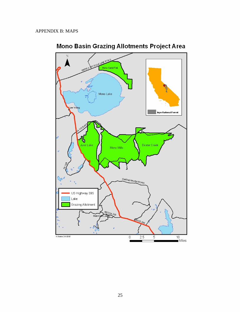
MONO BASIN GRAZING ALLOTMENTS PROPOSED...
29
Page 1 of 29 MONO BASIN GRAZING ALLOTMENTS PROPOSED ACTION This document outlines management actions that are proposed to meet the purpose and need for this project. The 1988 Inyo Land and Resource Management Plan (LRMP), the 1995 Forest Plan Amendment #6 – Forest-Wide Range Utilization Standards (Amendment 6), the 1990 Mono Basin National Forest Scenic Area Management Plan, and the Sierra Nevada Forest Plan Amendment (USDA Forest Service 2004) (SNFPA) provide direction and describe the desired conditions for vegetation, riparian, aquatic, hydrologic, water quality, soil, plant, animal and heritage resources. Resource condition assessments in 2008 and 2010, along with grazing history and monitoring data, provided the means to assess the difference between existing conditions and desired conditions. With this comparison, management actions were identified and a proposed action was developed. BACKGROUND There are five grazing allotments in the Mono Basin which vary in size from 8,696 acres to 29,263 acres. Of those, four are currently under analysis for this environmental assessment: Dexter Canyon, June Lake, Mono Mills and Mono Sand Flat. The fifth allotment, Black Canyon, will be analyzed at a later date. The Mono Basin Allotments stretch from the northeastern shore of Mono Lake to the northern slope of the Glass Mountains. They are bounded on the west by U.S. Highway 395 and on the east by Dexter Canyon. Elevations range from approximately 6,400 to 9,317 feet at Crooked Peak. The average annual precipitation is approximately 14 inches. All of the allotments lie entirely within Forest Plan Management Prescription 11 – Range Emphasis (maintaining a healthy, productive rangeland resource). According to the Forest Plan, the primary objectives of these areas are to maintain or increase forage production and achieve uniform livestock distribution through maintenance and expansion of structural and nonstructural range improvements. Secondary objectives include protection of watersheds and maintaining wildlife habitat. Recent assessments of the allotments have identified certain soil, water, and other resource conditions that are not meeting or moving toward desired objectives. As described in the “Purpose and Need” section below, these gaps between existing resource conditions and desired conditions indicate a need to change current management of the allotments. PURPOSE AND NEED The purpose and need for the proposed action is to move from existing to desired future conditions, which are described by certain Inyo National Forest standards and guidelines and management direction while continuing to provide for livestock grazing under updated allotment management plans in the Mono Lake Basin.
Transcript of MONO BASIN GRAZING ALLOTMENTS PROPOSED...
Page 1 of 29
MONO BASIN GRAZING ALLOTMENTS PROPOSED ACTION
This document outlines management actions that are proposed to meet the purpose and
need for this project. The 1988 Inyo Land and Resource Management Plan (LRMP), the
1995 Forest Plan Amendment #6 – Forest-Wide Range Utilization Standards
(Amendment 6), the 1990 Mono Basin National Forest Scenic Area Management Plan,
and the Sierra Nevada Forest Plan Amendment (USDA Forest Service 2004) (SNFPA)
provide direction and describe the desired conditions for vegetation, riparian, aquatic,
hydrologic, water quality, soil, plant, animal and heritage resources. Resource condition
assessments in 2008 and 2010, along with grazing history and monitoring data, provided
the means to assess the difference between existing conditions and desired conditions.
With this comparison, management actions were identified and a proposed action was
developed.
BACKGROUND
There are five grazing allotments in the Mono Basin which vary in size from 8,696 acres
to 29,263 acres. Of those, four are currently under analysis for this environmental
assessment: Dexter Canyon, June Lake, Mono Mills and Mono Sand Flat. The fifth
allotment, Black Canyon, will be analyzed at a later date.
The Mono Basin Allotments stretch from the northeastern shore of Mono Lake to the
northern slope of the Glass Mountains. They are bounded on the west by U.S. Highway
395 and on the east by Dexter Canyon. Elevations range from approximately 6,400 to
9,317 feet at Crooked Peak. The average annual precipitation is approximately 14 inches.
All of the allotments lie entirely within Forest Plan Management Prescription 11 – Range
Emphasis (maintaining a healthy, productive rangeland resource). According to the
Forest Plan, the primary objectives of these areas are to maintain or increase forage
production and achieve uniform livestock distribution through maintenance and
expansion of structural and nonstructural range improvements. Secondary objectives
include protection of watersheds and maintaining wildlife habitat.
Recent assessments of the allotments have identified certain soil, water, and other
resource conditions that are not meeting or moving toward desired objectives. As
described in the “Purpose and Need” section below, these gaps between existing resource
conditions and desired conditions indicate a need to change current management of the
allotments.
PURPOSE AND NEED
The purpose and need for the proposed action is to move from existing to desired future
conditions, which are described by certain Inyo National Forest standards and guidelines
and management direction while continuing to provide for livestock grazing under
updated allotment management plans in the Mono Lake Basin.
Page 2 of 29
1. There is a need for continued livestock grazing under updated allotment
management plans for the grazing allotments in the Mono Basin.
Livestock grazing has been identified as an appropriate use of National Forest System
lands which have been found to be capable and suitable for grazing. In the 1988 Inyo
National Forest Land and Resource Management Plan (LRMP), the allotments in the
Mono Basin were identified as being capable and suitable for livestock grazing based on
an assessment of forage production, accessibility, slope, and other factors (Management
Areas 1, 5 [pp. 152]). Field work in 2008 verified that the 4 allotments are currently
capable and suitable for grazing according to the criteria specified in the Forest Plan.
Authorization of livestock grazing and management in an adaptive manner is appropriate
on the project area because:
Where consistent with other multiple use goals and objectives there is
Congressional intent to allow grazing on suitable lands. (Multiple Use Sustained
Yield Act of 1960, Wilderness Act of 1964, Forest and Rangeland Renewable
Resources Planning Act of 1974, Federal Land Policy and Management Act of
1976, National Forest Management Act of 1976)
The allotments contain lands identified as suitable for domestic livestock grazing
in the Inyo National Forests Land and Resource Management Plan (LRMP or
“Forest Plan”) and continued domestic livestock grazing is consistent with the
goals, objectives, standards, and guidelines of the Forest Plan (LRMP pages III-
45, IV-67, IV-84-86, IV-134-135, and IV-210-212).
It is Forest Service policy to make forage available to qualified livestock
operators from lands suitable for grazing consistent with land management plans
(FSM 2203.1; 36 CFR 222.2 (c)).
It is Forest Service policy to continue contributions to the economic and social
well being of people by providing opportunities for economic diversity and by
promoting stability for communities that depend on range resources for their
livelihood (FSM 2202.1).
The Inyo Forest Plan, which directs the management of lands contained within
this project area, has as one of its Standards and Guidelines to “Provide grazing
tenure to lend stability to the local livestock-raising community and established
ranching operations”.
The current grazing allotment permittees expressed interest in continuing use of all four
allotments or alternate allotments. Continuation of livestock grazing will require review
of existing management strategies and, if necessary, updating them to implement current
Forest Plan direction and meet Section 504 of Public Law 104-19 (Rescissions Act,
signed July 27, 1995).
Page 3 of 29
2. There is a need for improved range vegetation condition and trend where
existing conditions are not meeting or moving toward desired vegetation
condition.
The LRMP, Amendment 6, and the SNFPA provide direction and the desired conditions
for range vegetation.
Evaluations in 2008 and 2010 identified portions of allotments in which desired
vegetative conditions were not being met. In the Mono Sand Flat Allotments, grazing has
resulted in a low density of desirable species (shrubs, bunchgrasses and herbaceous
vegetation) that does not meet standards for desired vegetative composition of this
community (LRMP, p.76).
In the Dexter Creek, June Lake and Mono Sand Flat Allotments, portions of the desert
shrub and bitterbrush communities do not meet standards for vegetative condition, being
moderately to severely hedged or browsed without sufficient annual recovery (LRMP,
pp.76, 105). There is also a need to ensure sufficient forage for mule deer after livestock
grazing season with total annual browse utilization that maintains bitterbrush condition
(LRMP, pp.85, 98-99, and 117).
EXISTING CONDITIONS
Sheep and cattle have grazed the entire project area since the late 19th
Century. Most of
the rangelands in this proposal have been grazed under permit with the Forest Service
since the creation of the Inyo National Forest in 1907.
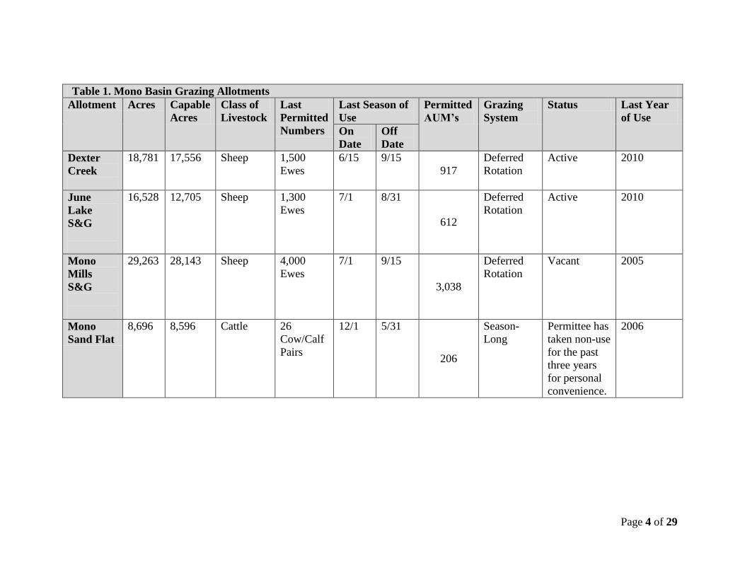
The four allotments subject to this environmental analysis are Dexter Canyon, June Lake,
Mono Mills and Mono Sand Flat. Grazing in the allotments is authorized by Term
Grazing Permits that specify the terms and conditions for grazing on the allotment,
including the type and timing of livestock as well as any management actions necessary
to meet desired rangeland conditions. Table 1 summarizes the current status of each
allotment.
Page 4 of 29
Table 1. Mono Basin Grazing Allotments
Allotment Acres Capable
Acres
Class of
Livestock
Last
Permitted
Numbers
Last Season of
Use
Permitted
AUM’s
Grazing
System
Status Last Year
of Use
On
Date
Off
Date
Dexter
Creek
18,781 17,556 Sheep 1,500
Ewes
6/15 9/15
917
Deferred
Rotation
Active 2010
June
Lake
S&G
16,528 12,705 Sheep 1,300
Ewes
7/1 8/31
612
Deferred
Rotation
Active 2010
Mono
Mills
S&G
29,263 28,143 Sheep 4,000
Ewes
7/1 9/15
3,038
Deferred
Rotation
Vacant 2005
Mono
Sand Flat
8,696 8,596 Cattle 26
Cow/Calf
Pairs
12/1 5/31
206
Season-
Long
Permittee has
taken non-use
for the past
three years
for personal
convenience.
2006
Page 5 of 29
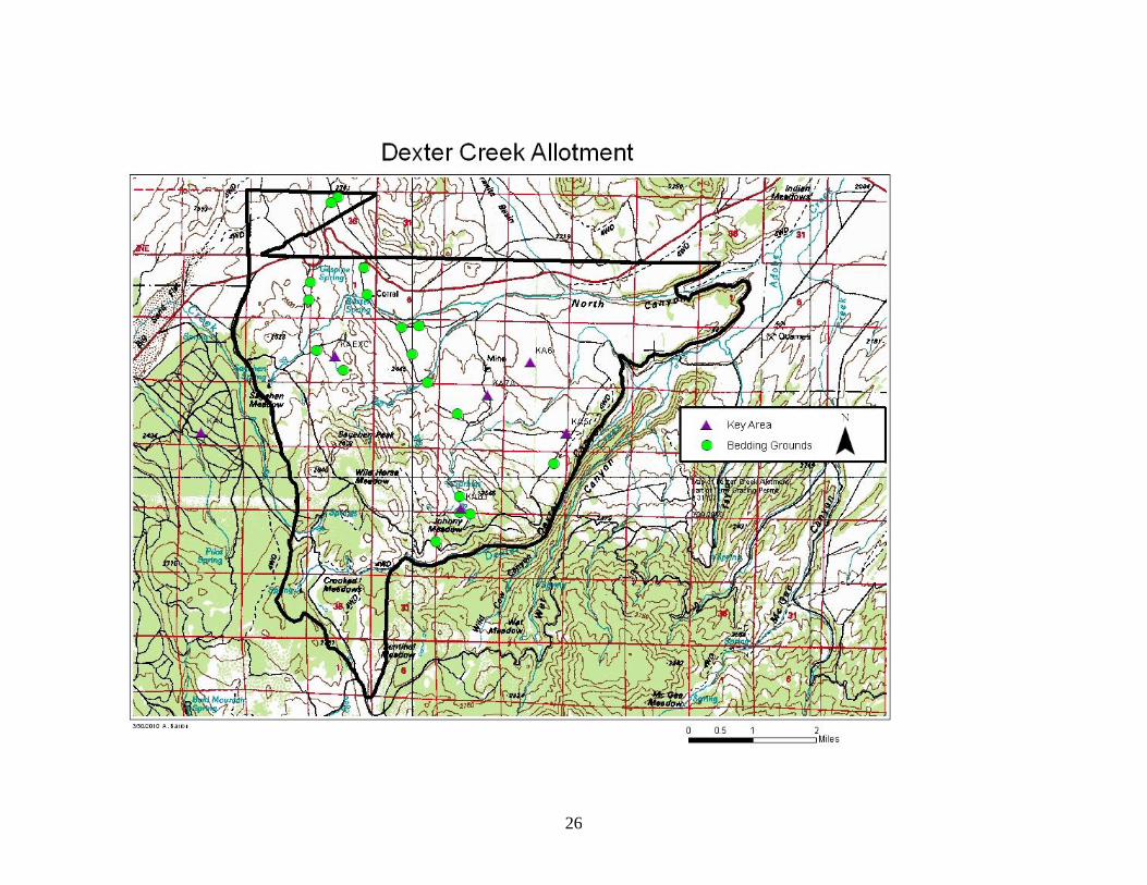
Dexter Creek
Dexter Creek Allotment is located approximately five miles southeast of Mono Lake. Its
boundaries are Dry Creek on the west, Dexter Creek on the east, the northern side of the
Glass Mountains on the south, and the Forest boundary (mainly running along Highway
120) on the north. The legal description is T1S, R28E, Sections 1, 2, 11- 14, 23-26, 35,
36; T1S, R29E, Sections 1-22, 24- 26, 28- 31; T2S, R28E, Section 1.
The primary forage species are bitterbrush and bunchgrasses.
Dexter Creek is used as a sheep allotment by the I&M Sheep Company. With two
exceptions, which are noted below, the I&M Company has used the same rotation for the
past ten years. The pattern is as follows:
1. On approximately July 2, unload sheep at Sagehen Summit – sheep will graze
toward the valley between the Summit and Baxter Springs, avoiding pockets of
freeze damaged Bitterbrush.
2. Baxter Corral/Springs – water sheep at road crossing and limit sheep bedding
ground to the north side of creek only. Avoid grazing along streambanks and
riparian areas.
3. Draft livestock water from Baxter Springs at road crossing.
4. Lower Dexter Bench – water sheep at road crossing in North Canyon, at end of
FS Road 1S15A, and at end of unnumbered road in NE 1/4 Sec. 18. After
watering, push sheep to higher ground away from creek. All other watering will
be done via truck except for one watering site at Dexter Creek.
5. Avoid wet areas and streams on upper Johnny Meadows.
6. Wild Horse Canyon to Crooked Meadows Road – sheep are allowed to water in
Dexter Creek at road crossing in SW ¼ Section 30. Wild horse Meadow – sheep
will bed in trees between FS Road 1N02 and meadow. Wild horse Meadow is
closed to grazing for resource protection.
7. Sagehen Peak to Sagehen Meadow – Meadow and downstream riparian/stock
pond has water. Bed sheep uphill away from dry meadow/stock pond. Making a
once over pass along riparian upstream of pond is approved. Avoid grazing onto
private property near edge of meadow and first gabion downstream of meadow
“proper”.
8. Gas Pipe Spring and north of Hwy 120 to BLM allotment by September 15.
Page 6 of 29
The first exception is that before 2004, the sheep would not be unloaded at Sagehen
Summit, but would start at Baxter Springs (step 2). The second exception is that Johnny
Meadow was rested from 2002 to 2008.
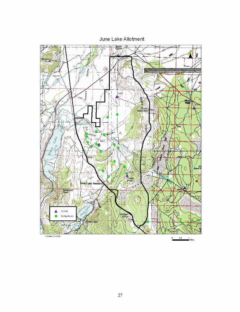
June Lake
The June Lake Allotment is located approximately two miles south of Mono Lake. Its
boundaries are U.S. Highway 395 on the west, the Forest Boundary on the north, the
Mono Craters on the east, and Wilson Butte on the south. Its legal description is: T1N,
R27E, Sections 29-33; T1S, R27E, Sections 3-10, 15-22, 28-33, T2S. R27E, Sections 4-
9.
The primary forage species are bitterbrush and bunchgrasses.
June Lake is run as a sheep allotment by the I&M Sheep Company. The rotation of sheep
through the allotment has been the same since 1994. The rotation is as follows:
1. Enter Allotment on approximately July 1
2. Upper Aqueduct road (1N11) to poleline .
3. Poleline road to 1N11.
4. 1N11 southeast to 1S35.
5. 1S35 South to 1S40.
6. Devil’s Punch Bowl area.
7. North along Mono Craters to Lousy Fire
8. Exit allotment on approximately August 31.
Mono Mills
Mono Mills Allotment is located between the June Lake and Dexter Creek Allotment. Its
boundaries are the Mono Craters on the west, Highway 120 and the Forest boundary on
the north, Dry Creek on the east, and generally the northern side of the Glass Mountains
on the south. The legal description is: T1N, R27E, Sections 33, 34, 28; T1S, R27E,
Sections 1-3, 10-15, 22-28, 33-36; T2S, R28E, Sections 1-4, 10, 11; T1S, R28E, Sections
3-10, 14-23, 26-35; T1N, R28E, Sections 3-6, 7.
Page 7 of 29
Mono Mills Allotment is currently vacant but has previously been used as a sheep
allotment. The earliest use in the Forest Service records is 1941, but the allotment has
most likely been grazed by sheep since the late nineteenth century.
The primary forage species are bitterbrush and bunchgrasses.
Mono Sand Flat
The Mono Sand Flat Allotment is located along the northeastern shore of Mono Lake.
The northern and eastern boundaries are the Forest boundary and the rest of the boundary
is along the shoreline. The legal description is T3N, R27E, Sections 22-35; T3N, R28E,
Sections 30-32; T2N, R28E, Sections 5-9, 21, 28, 32, 33.
Mono Sand Flat is used as a cattle allotment by the Hilton Family Trust. The Term
Grazing Permit allows for 26 cattle to use the allotment between December 1 and May
31. However, the permittee has taken non-use for personal convenience since 2006.
The conditions on this allotment do not meet Amendment 6 standards because there is a
lack of desirable species. Soil conditions are very dry and some pedestalling is apparent.
This allotment would not currently support grazing by livestock.
8
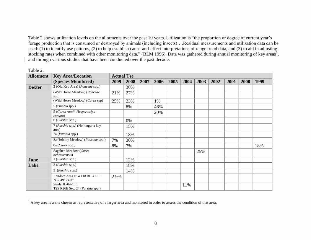
Table 2 shows utilization levels on the allotments over the past 10 years. Utilization is “the proportion or degree of current year’s
forage production that is consumed or destroyed by animals (including insects)….Residual measurements and utilization data can be
used: (1) to identify use patterns, (2) to help establish cause-and-effect interpretations of range trend data, and (3) to aid in adjusting
stocking rates when combined with other monitoring data.” (BLM 1996). Data was gathered during annual monitoring of key areas1,
and through various studies that have been conducted over the past decade.
Table 2.
Allotment Key Area/Location
(Species Monitored)
Actual Use
2009 2008 2007 2006 2005 2004 2003 2002 2001 2000 1999
Dexter 2 (Old Key Area) (Poaceae spp.) 30% (Wild Horse Meadow) (Poaceae
spp.) 21% 27%
(Wild Horse Meadow) (Carex spp) 25% 23% 1% 5 (Purshia spp.) 8% 46% 5 (Carex rossii, Hesperostipa
comata) 20%
6 (Purshia spp.) 0% 7 (Purshia spp.) (No longer a key
area) 15%
7a (Purshia spp.) 18% 8a (Johnny Meadow) (Poaceae spp.) 7% 30% 8a (Carex spp.) 8% 7% 18% Sagehen Meadow (Carex
nebrascensis) 25%
June
Lake
1 (Purshia spp.) 12% 2 (Purshia spp.) 18% 3 (Purshia spp.) 14% Random Area at W118 01’ 41.7”
N37 49’ 24.8” 2.9%
Study JL-04-1 in
T2S R26E Sec. 24 (Purshia spp.) 11%
1 A key area is a site chosen as representative of a larger area and monitored in order to assess the condition of that area.
9
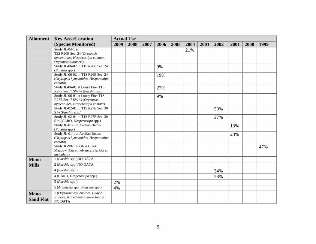
Allotment Key Area/Location
(Species Monitored)
Actual Use
2009 2008 2007 2006 2005 2004 2003 2002 2001 2000 1999
Study JL-04-1 in
T2S R26E Sec. 24 (Oryzopsis
hymenoides, Hesperostipa comata,
Oryzopsis bloomeri)
21%
Study JL-06-02 in T1S R26E Sec. 24
(Purshia spp.) 9%
Study JL-06-02 in T1S R26E Sec. 24
(Oryzopsis hymenoides, Hesperostipa
comata)
19%
Study JL-06-01 at Lousy Fire T1S
R27E Sec. 7 SW ¼ (Purshia spp.) 27%
Study JL-06-01 at Lousy Fire T1S
R27E Sec. 7 SW ¼ (Oryzopsis
hymenoides, Hesperostipa comata)
9%
Study JL-02-01 in T1S R27E Sec. 30
S ½ (Purshia spp.) 50%
Study JL-02-01 in T1S R27E Sec. 30
S ½ (CARO, Hesperostipa spp.) 27%
Study JL-01-1 at Aeolian Buttes
(Purshia spp.) 13%
Study JL-01-1 at Aeolian Buttes
(Oryzopsis hymenoides, Hesperostipa
comata)
23%
Study JL-99-1 at Glass Creek
Meadow (Carex nebrascensis, Carex
utriculata)
47%
Mono
Mills
1 (Purshia spp.)NO DATA 2 (Purshia spp.)NO DATA 4 (Purshia spp.) 34% 4 (CARO, Hesperostipa spp.) 28% 5 (Purshia spp.) 2% 5 (Artemesia spp., Poaceae spp.) 4%
Mono
Sand Flat
1 (Oryzopsis hymenoides, Grayia
spinosa, Krascheninnikovia lanata)
NO DATA
10
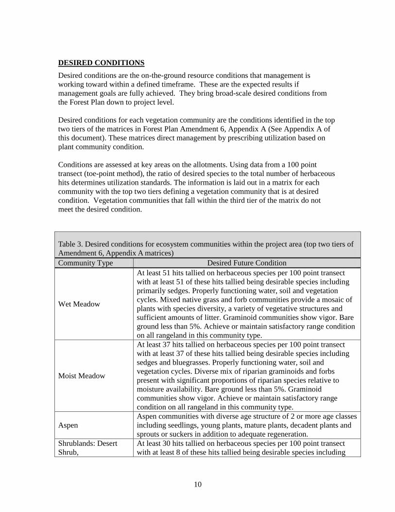
DESIRED CONDITIONS
Desired conditions are the on-the-ground resource conditions that management is
working toward within a defined timeframe. These are the expected results if
management goals are fully achieved. They bring broad-scale desired conditions from
the Forest Plan down to project level.
Desired conditions for each vegetation community are the conditions identified in the top
two tiers of the matrices in Forest Plan Amendment 6, Appendix A (See Appendix A of
this document). These matrices direct management by prescribing utilization based on
plant community condition.
Conditions are assessed at key areas on the allotments. Using data from a 100 point
transect (toe-point method), the ratio of desired species to the total number of herbaceous
hits determines utilization standards. The information is laid out in a matrix for each
community with the top two tiers defining a vegetation community that is at desired
condition. Vegetation communities that fall within the third tier of the matrix do not
meet the desired condition.
Table 3. Desired conditions for ecosystem communities within the project area (top two tiers of
Amendment 6, Appendix A matrices)
Community Type Desired Future Condition
Wet Meadow
At least 51 hits tallied on herbaceous species per 100 point transect
with at least 51 of these hits tallied being desirable species including
primarily sedges. Properly functioning water, soil and vegetation
cycles. Mixed native grass and forb communities provide a mosaic of
plants with species diversity, a variety of vegetative structures and
sufficient amounts of litter. Graminoid communities show vigor. Bare
ground less than 5%. Achieve or maintain satisfactory range condition
on all rangeland in this community type.
Moist Meadow
At least 37 hits tallied on herbaceous species per 100 point transect
with at least 37 of these hits tallied being desirable species including
sedges and bluegrasses. Properly functioning water, soil and
vegetation cycles. Diverse mix of riparian graminoids and forbs
present with significant proportions of riparian species relative to
moisture availability. Bare ground less than 5%. Graminoid
communities show vigor. Achieve or maintain satisfactory range
condition on all rangeland in this community type.
Aspen
Aspen communities with diverse age structure of 2 or more age classes
including seedlings, young plants, mature plants, decadent plants and
sprouts or suckers in addition to adequate regeneration.
Shrublands: Desert
Shrub,
At least 30 hits tallied on herbaceous species per 100 point transect
with at least 8 of these hits tallied being desirable species including
11
Table 3. Desired conditions for ecosystem communities within the project area (top two tiers of
Amendment 6, Appendix A matrices)
Community Type Desired Future Condition
Sagebrush/Bunchgrass
and Bitterbrush
needlegrass, ricegrass and squirrel tail grass. Vigorous growth and
regeneration of mid-late seral shrub species interspersed with a variety
of native grasses and forbs. Properly functioning water, soil and
vegetation cycles. Achieve or maintain satisfactory range condition on
all rangeland in this community type.
Streams & Riparian
areas
Properly functioning water, soil and vegetation cycles; reproducing
riparian plant communities, at least 80% of the potential vegetative
cover along streams; stable, defined channels with appropriate
width/depth ratios for stream type; less than 20% of streambank
actively eroding, balanced erosion/deposition levels. Maintain at
least 80% of potential ground cover within 100’ from the edges of
all perennial streams, or to the outer margin of the riparian
ecosystem, where wider than 100 feet. Plant species may include
sedges, rushes, tufted hairgrass, willow, birch, aspen and
cottonwood of mixed age class. In woody systems, riparian shrubs
cover of at least 35% to include a variety of species. Achieve or
maintain satisfactory range condition on all rangeland in this
community type.
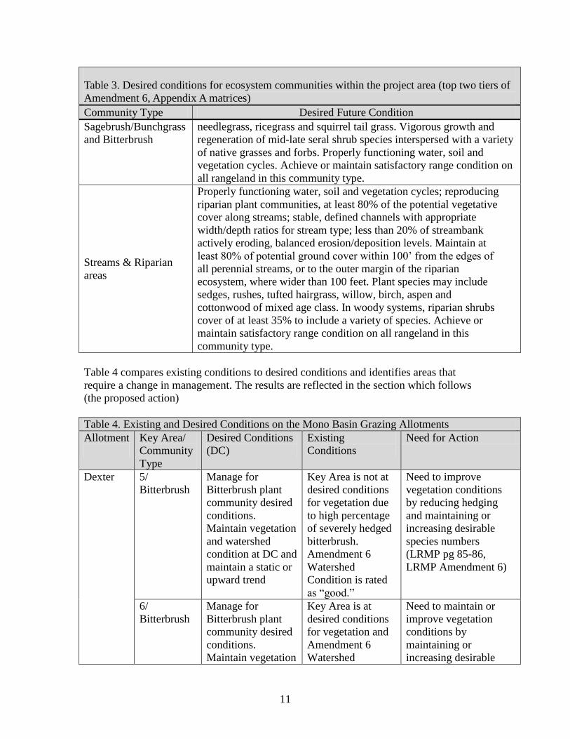
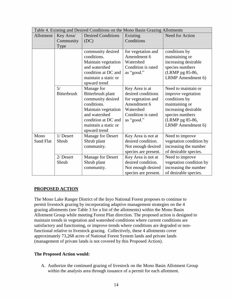
Table 4 compares existing conditions to desired conditions and identifies areas that
require a change in management. The results are reflected in the section which follows
(the proposed action)
Table 4. Existing and Desired Conditions on the Mono Basin Grazing Allotments
Allotment
Key Area/
Community
Type
Desired Conditions
(DC)
Existing
Conditions
Need for Action
Dexter 5/
Bitterbrush
Manage for
Bitterbrush plant
community desired
conditions.
Maintain vegetation
and watershed
condition at DC and
maintain a static or
upward trend
Key Area is not at
desired conditions
for vegetation due
to high percentage
of severely hedged
bitterbrush.
Amendment 6
Watershed
Condition is rated
as “good.”
Need to improve
vegetation conditions
by reducing hedging
and maintaining or
increasing desirable
species numbers
(LRMP pg 85-86,
LRMP Amendment 6)
6/
Bitterbrush
Manage for
Bitterbrush plant
community desired
conditions.
Maintain vegetation
Key Area is at
desired conditions
for vegetation and
Amendment 6
Watershed
Need to maintain or
improve vegetation
conditions by
maintaining or
increasing desirable
12
Table 4. Existing and Desired Conditions on the Mono Basin Grazing Allotments
Allotment
Key Area/
Community
Type
Desired Conditions
(DC)
Existing
Conditions
Need for Action
and watershed
condition at DC and
maintain a static or
upward trend
Condition is rated
as “good.”
species numbers
(LRMP pg 85-86,
LRMP Amendment 6)
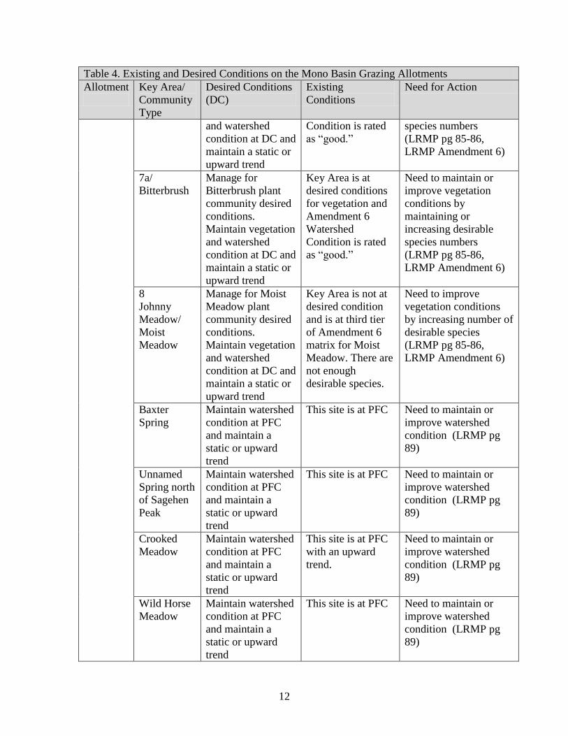
7a/
Bitterbrush
Manage for
Bitterbrush plant
community desired
conditions.
Maintain vegetation
and watershed
condition at DC and
maintain a static or
upward trend
Key Area is at
desired conditions
for vegetation and
Amendment 6
Watershed
Condition is rated
as “good.”
Need to maintain or
improve vegetation
conditions by
maintaining or
increasing desirable
species numbers
(LRMP pg 85-86,
LRMP Amendment 6)
8
Johnny
Meadow/
Moist
Meadow
Manage for Moist
Meadow plant
community desired
conditions.
Maintain vegetation
and watershed
condition at DC and
maintain a static or
upward trend
Key Area is not at
desired condition
and is at third tier
of Amendment 6
matrix for Moist
Meadow. There are
not enough
desirable species.
Need to improve
vegetation conditions
by increasing number of
desirable species
(LRMP pg 85-86,
LRMP Amendment 6)
Baxter
Spring
Maintain watershed
condition at PFC
and maintain a
static or upward
trend
This site is at PFC Need to maintain or
improve watershed
condition (LRMP pg
89)
Unnamed
Spring north
of Sagehen
Peak
Maintain watershed
condition at PFC
and maintain a
static or upward
trend
This site is at PFC Need to maintain or
improve watershed
condition (LRMP pg
89)
Crooked
Meadow
Maintain watershed
condition at PFC
and maintain a
static or upward
trend
This site is at PFC
with an upward
trend.
Need to maintain or
improve watershed
condition (LRMP pg
89)
Wild Horse
Meadow
Maintain watershed
condition at PFC
and maintain a
static or upward
trend
This site is at PFC Need to maintain or
improve watershed
condition (LRMP pg
89)
13
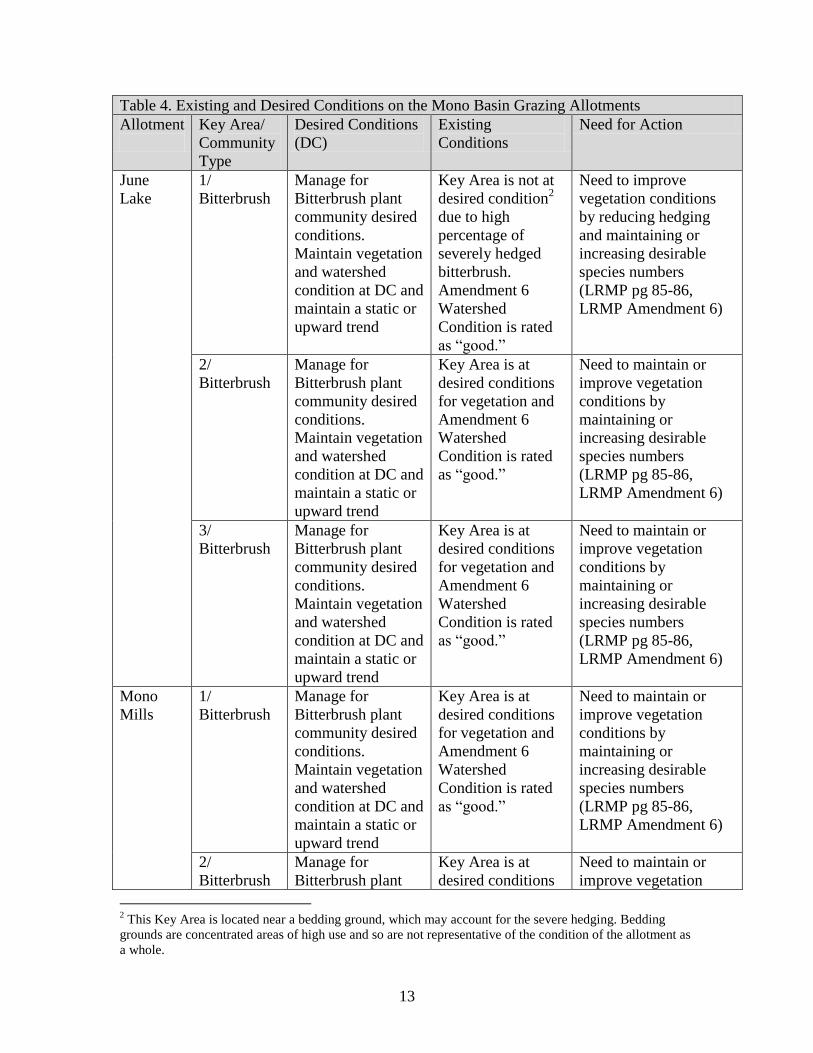
Table 4. Existing and Desired Conditions on the Mono Basin Grazing Allotments
Allotment
Key Area/
Community
Type
Desired Conditions
(DC)
Existing
Conditions
Need for Action
June
Lake
1/
Bitterbrush
Manage for
Bitterbrush plant
community desired
conditions.
Maintain vegetation
and watershed
condition at DC and
maintain a static or
upward trend
Key Area is not at
desired condition2
due to high
percentage of
severely hedged
bitterbrush.
Amendment 6
Watershed
Condition is rated
as “good.”
Need to improve
vegetation conditions
by reducing hedging
and maintaining or
increasing desirable
species numbers
(LRMP pg 85-86,
LRMP Amendment 6)
2/
Bitterbrush
Manage for
Bitterbrush plant
community desired
conditions.
Maintain vegetation
and watershed
condition at DC and
maintain a static or
upward trend
Key Area is at
desired conditions
for vegetation and
Amendment 6
Watershed
Condition is rated
as “good.”
Need to maintain or
improve vegetation
conditions by
maintaining or
increasing desirable
species numbers
(LRMP pg 85-86,
LRMP Amendment 6)
3/
Bitterbrush
Manage for
Bitterbrush plant
community desired
conditions.
Maintain vegetation
and watershed
condition at DC and
maintain a static or
upward trend
Key Area is at
desired conditions
for vegetation and
Amendment 6
Watershed
Condition is rated
as “good.”
Need to maintain or
improve vegetation
conditions by
maintaining or
increasing desirable
species numbers
(LRMP pg 85-86,
LRMP Amendment 6)
Mono
Mills
1/
Bitterbrush
Manage for
Bitterbrush plant
community desired
conditions.
Maintain vegetation
and watershed
condition at DC and
maintain a static or
upward trend
Key Area is at
desired conditions
for vegetation and
Amendment 6
Watershed
Condition is rated
as “good.”
Need to maintain or
improve vegetation
conditions by
maintaining or
increasing desirable
species numbers
(LRMP pg 85-86,
LRMP Amendment 6)
2/
Bitterbrush
Manage for
Bitterbrush plant
Key Area is at
desired conditions
Need to maintain or
improve vegetation
2 This Key Area is located near a bedding ground, which may account for the severe hedging. Bedding
grounds are concentrated areas of high use and so are not representative of the condition of the allotment as
a whole.
14
Table 4. Existing and Desired Conditions on the Mono Basin Grazing Allotments
Allotment
Key Area/
Community
Type
Desired Conditions
(DC)
Existing
Conditions
Need for Action
community desired
conditions.
Maintain vegetation
and watershed
condition at DC and
maintain a static or
upward trend
for vegetation and
Amendment 6
Watershed
Condition is rated
as “good.”
conditions by
maintaining or
increasing desirable
species numbers
(LRMP pg 85-86,
LRMP Amendment 6)
5/
Bitterbrush
Manage for
Bitterbrush plant
community desired
conditions.
Maintain vegetation
and watershed
condition at DC and
maintain a static or
upward trend
Key Area is at
desired conditions
for vegetation and
Amendment 6
Watershed
Condition is rated
as “good.”
Need to maintain or
improve vegetation
conditions by
maintaining or
increasing desirable
species numbers
(LRMP pg 85-86,
LRMP Amendment 6)
Mono
Sand Flat
1/ Desert
Shrub
Manage for Desert
Shrub plant
community.
Key Area is not at
desired condition.
Not enough desired
species are present.
Need to improve
vegetation condition by
increasing the number
of desirable species.
2/ Desert
Shrub
Manage for Desert
Shrub plant
community.
Key Area is not at
desired condition.
Not enough desired
species are present.
Need to improve
vegetation condition by
increasing the number
of desirable species.
PROPOSED ACTION
The Mono Lake Ranger District of the Inyo National Forest proposes to continue to
permit livestock grazing by incorporating adaptive management strategies on the 4
grazing allotments (see Table 3 for a list of the allotments) within the Mono Basin
Allotment Group while meeting Forest Plan direction. The proposed action is designed to
maintain trends in vegetation and watershed conditions where current conditions are
satisfactory and functioning, or improve trends where conditions are degraded or non-
functional relative to livestock grazing. Collectively, these 4 allotments cover
approximately 73,268 acres of National Forest System lands and private lands
(management of private lands is not covered by this Proposed Action).
The Proposed Action would:
A. Authorize the continued grazing of livestock on the Mono Basin Allotment Group
within the analysis area through issuance of a permit for each allotment.
15
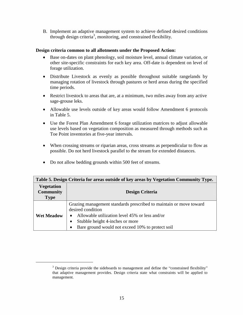
B. Implement an adaptive management system to achieve defined desired conditions
through design criteria3, monitoring, and constrained flexibility.
Design criteria common to all allotments under the Proposed Action:
Base on-dates on plant phenology, soil moisture level, annual climate variation, or
other site-specific constraints for each key area. Off-date is dependent on level of
forage utilization.
Distribute Livestock as evenly as possible throughout suitable rangelands by
managing rotation of livestock through pastures or herd areas during the specified
time periods.
Restrict livestock to areas that are, at a minimum, two miles away from any active
sage-grouse leks.
Allowable use levels outside of key areas would follow Amendment 6 protocols
in Table 5.
Use the Forest Plan Amendment 6 forage utilization matrices to adjust allowable
use levels based on vegetation composition as measured through methods such as
Toe Point inventories at five-year intervals.
When crossing streams or riparian areas, cross streams as perpendicular to flow as
possible. Do not herd livestock parallel to the stream for extended distances.
Do not allow bedding grounds within 500 feet of streams.
Table 5. Design Criteria for areas outside of key areas by Vegetation Community Type.
Vegetation
Community
Type
Design Criteria
Wet Meadow
Grazing management standards prescribed to maintain or move toward
desired condition
Allowable utilization level 45% or less and/or
Stubble height 4-inches or more
Bare ground would not exceed 10% to protect soil
3 Design criteria provide the sideboards to management and define the “constrained flexibility”
that adaptive management provides. Design criteria state what constraints will be applied to
management.
16
Table 5. Design Criteria for areas outside of key areas by Vegetation Community Type.
Vegetation
Community
Type
Design Criteria
Upland and
Shrublands (including
Bitterbrush
and Sagebrush
Communities)
Grazing management standards prescribed to maintain or move toward
desired condition
Allowable herbaceous utilization level 50% or less
Allowable browse utilization level 45% or less and/or
Residual dry matter average of 300 pounds per acre or more to protect
soil
Riparian
Grazing management standards prescribed to maintain or move toward
desired condition
Allowable herbaceous utilization level 45% or less
Allowable browse utilization level 20% of annual leader growth of
hardwood seedlings and advanced regeneration.
Streambanks would not exceed 20% disturbance per reach
Adaptive grazing management allows land managers to use monitoring as a tool to
achieve desired conditions. If monitoring shows that goals continue to go unmet, new
actions may be taken in order to move towards those goals. The new actions would be set
forth in each allotment’s Annual Operating Instructions. Table 6 summarizes possible
actions that could be used in an adaptive management approach.
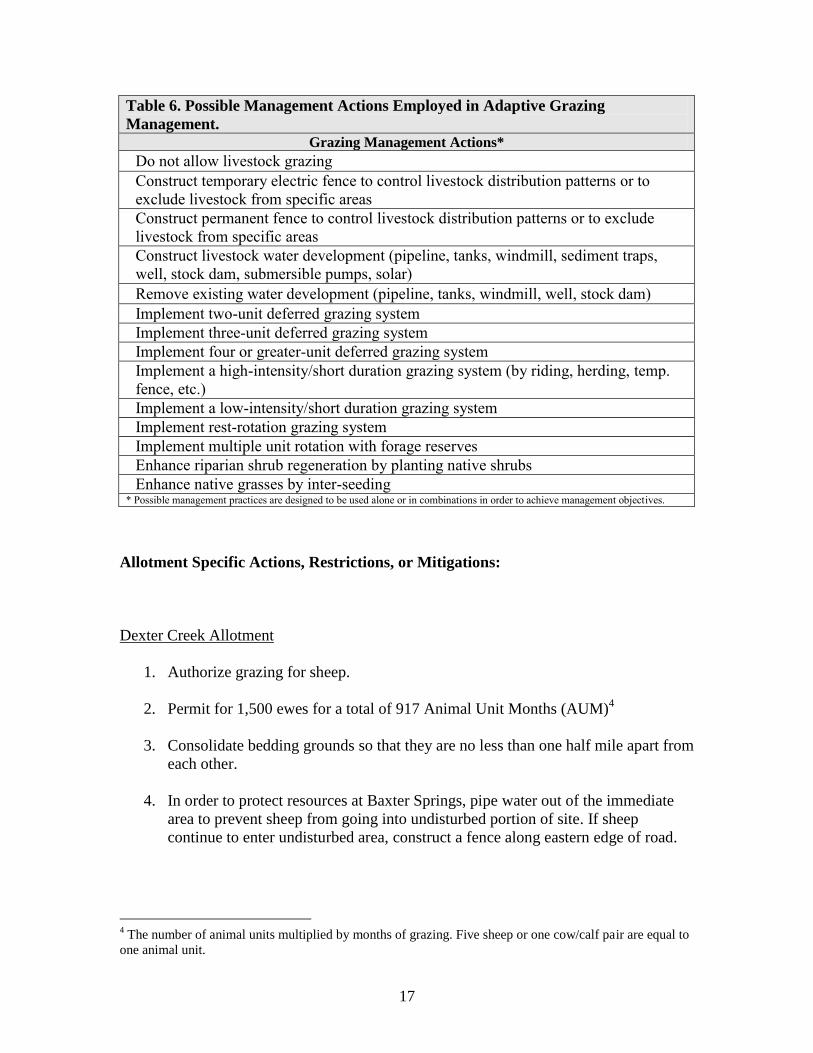
Table 6. Possible Management Actions Employed in Adaptive Grazing
Management.
Grazing Management Actions*
Adjust stocking rate to light, moderate or heavy grazing intensity (light refers to fewer
number of animals grazing for a longer period of time; heavy refers to larger number
of animals grazing for a shorter period of time)
Implement alternative riparian grazing dates based upon specific conditions
(topography, range rider, upland water sources, livestock use patterns)
Use of salt or supplement to draw livestock toward or away from specific areas
Incorporate a range rider to move livestock from riparian areas (herding)
Incorporate use of herding dogs to move livestock from riparian areas
Change season of use – do not exceed permitted animal unit months (stocking rate)
Change animal numbers – do not exceed permitted animal unit months (stocking rate)
Change animal class – do not exceed permitted animal unit months (stocking rate)
Change number of days of livestock utilization
Adjust utilization levels based on the current vegetation and watershed condition, per
Amendment 6 protocol
Defer livestock turn-on date
Rest from livestock grazing for one or more seasons
17
Table 6. Possible Management Actions Employed in Adaptive Grazing
Management.
Grazing Management Actions*
Do not allow livestock grazing
Construct temporary electric fence to control livestock distribution patterns or to
exclude livestock from specific areas
Construct permanent fence to control livestock distribution patterns or to exclude
livestock from specific areas
Construct livestock water development (pipeline, tanks, windmill, sediment traps,
well, stock dam, submersible pumps, solar)
Remove existing water development (pipeline, tanks, windmill, well, stock dam)
Implement two-unit deferred grazing system
Implement three-unit deferred grazing system
Implement four or greater-unit deferred grazing system
Implement a high-intensity/short duration grazing system (by riding, herding, temp.
fence, etc.)
Implement a low-intensity/short duration grazing system
Implement rest-rotation grazing system
Implement multiple unit rotation with forage reserves
Enhance riparian shrub regeneration by planting native shrubs
Enhance native grasses by inter-seeding * Possible management practices are designed to be used alone or in combinations in order to achieve management objectives.
Allotment Specific Actions, Restrictions, or Mitigations:
Dexter Creek Allotment
1. Authorize grazing for sheep.
2. Permit for 1,500 ewes for a total of 917 Animal Unit Months (AUM)4
3. Consolidate bedding grounds so that they are no less than one half mile apart from
each other.
4. In order to protect resources at Baxter Springs, pipe water out of the immediate
area to prevent sheep from going into undisturbed portion of site. If sheep
continue to enter undisturbed area, construct a fence along eastern edge of road.
4 The number of animal units multiplied by months of grazing. Five sheep or one cow/calf pair are equal to
one animal unit.
18
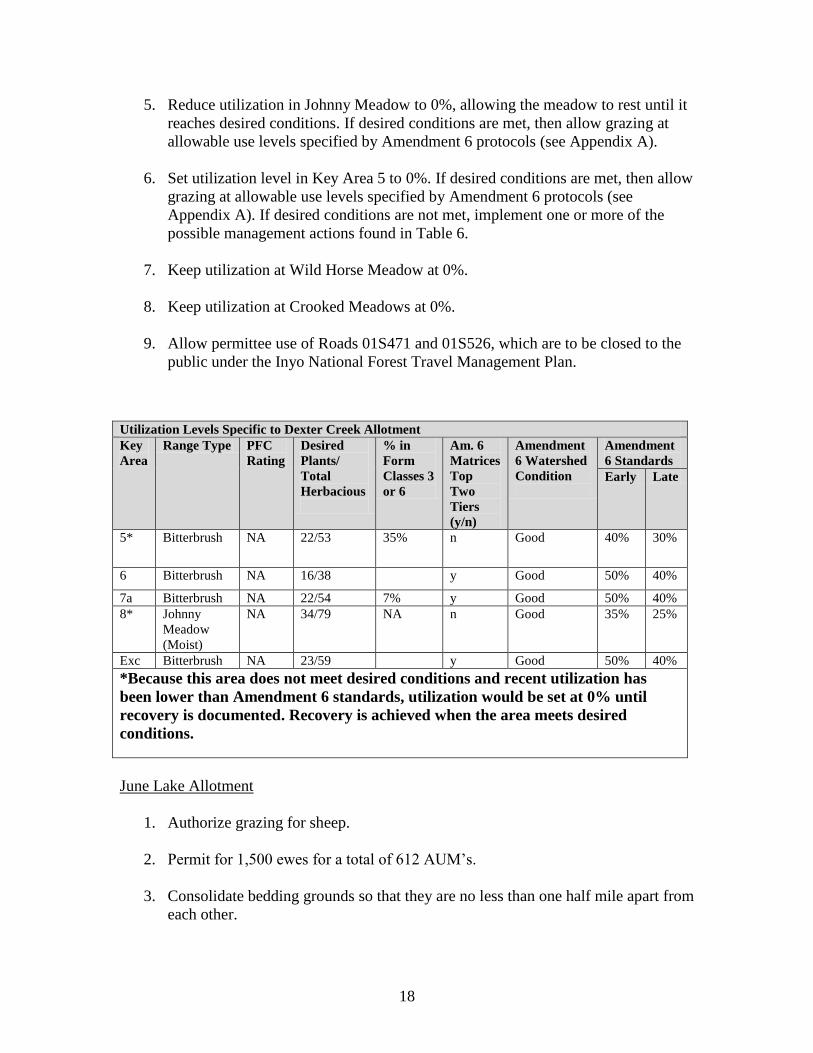
5. Reduce utilization in Johnny Meadow to 0%, allowing the meadow to rest until it
reaches desired conditions. If desired conditions are met, then allow grazing at
allowable use levels specified by Amendment 6 protocols (see Appendix A).
6. Set utilization level in Key Area 5 to 0%. If desired conditions are met, then allow
grazing at allowable use levels specified by Amendment 6 protocols (see
Appendix A). If desired conditions are not met, implement one or more of the
possible management actions found in Table 6.
7. Keep utilization at Wild Horse Meadow at 0%.
8. Keep utilization at Crooked Meadows at 0%.
9. Allow permittee use of Roads 01S471 and 01S526, which are to be closed to the
public under the Inyo National Forest Travel Management Plan.
Utilization Levels Specific to Dexter Creek Allotment
Key
Area
Range Type PFC
Rating
Desired
Plants/
Total
Herbacious
% in
Form
Classes 3
or 6
Am. 6
Matrices
Top
Two
Tiers
(y/n)
Amendment
6 Watershed
Condition
Amendment
6 Standards
Early Late
5* Bitterbrush NA 22/53 35% n Good 40% 30%
6 Bitterbrush NA 16/38 y Good 50% 40%
7a Bitterbrush NA 22/54 7% y Good 50% 40%
8* Johnny
Meadow
(Moist)
NA 34/79 NA n
Good 35% 25%
Exc Bitterbrush NA 23/59 y Good 50% 40%
*Because this area does not meet desired conditions and recent utilization has
been lower than Amendment 6 standards, utilization would be set at 0% until
recovery is documented. Recovery is achieved when the area meets desired
conditions.
June Lake Allotment
1. Authorize grazing for sheep.
2. Permit for 1,500 ewes for a total of 612 AUM’s.
3. Consolidate bedding grounds so that they are no less than one half mile apart from
each other.

19
4. Set utilization in Key Area 1 to 0% until recovery is documented. If desired
conditions are met, then allow grazing at allowable use levels specified by
Amendment 6 protocols (see Appendix A). If desired conditions are not met,
implement one or more of the possible management actions found in Table 6.
5. Restrict use of the Mono Fire area until recovery is documented.
6. Water tanks on this allotment will not be moved or repaired until evaluated by a
heritage specialist.
Utilization Levels Specific to June Lake Allotment
Key
Area
Range
Type
PFC
Rating
Desired
Plants/
Total
Herbacious
% in
Form
Classes
3 or 6
Am. 6
Matrices
Top
Two
Tiers
(y/n)
Amendment
6 Watershed
Condition
Amendment
6 Standards
Early Late
1* Bitterbrush NA 43/62 32% n Good 40% 30%
2 Bitterbrush NA 21/44 0% y Good 50% 40%
3 Bitterbrush 38/49 0% y Good 50% 40%
*Because this area does not meet desired conditions and recent utilization has
been lower than Amendment 6 standards, utilization would be set at 0% until
recovery is documented. Recovery is achieved when the area meets desired
conditions.
Mono Mills Allotment
1. Authorize grazing for sheep.
2. Permit for 4,000 ewes for a total of 3,038 AUM’s.
3. No sheep bedding grounds are authorized in Mono Mills Townsite.
4. Remove sheep bedding ground/high use area from water pond, water collection
site south of Highway 120 in the Big Sand Flat area.
5. Improve livestock distribution by installing a centrally located well and water
tank to provide approximately 4,000 gallons of water per day. Permittees would
use this site to fill water trucks and take the water elsewhere. Livestock would not
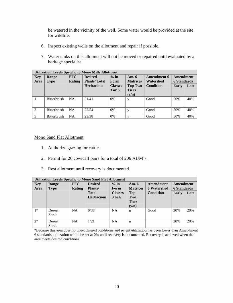
20
be watered in the vicinity of the well. Some water would be provided at the site
for wildlife.
6. Inspect existing wells on the allotment and repair if possible.
7. Water tanks on this allotment will not be moved or repaired until evaluated by a
heritage specialist.
Utilization Levels Specific to Mono Mills Allotment
Key
Area
Range
Type
PFC
Rating
Desired
Plants/ Total
Herbacious
% in
Form
Classes
3 or 6
Am. 6
Matrices
Top Two
Tiers
(y/n)
Amendment 6
Watershed
Condition
Amendment
6 Standards
Early Late
1 Bitterbrush NA 31/41 0% y Good 50% 40%
2 Bitterbrush NA 22/54 0% y Good 50% 40%
5 Bitterbrush NA 23/38 0% y Good 50% 40%
Mono Sand Flat Allotment
1. Authorize grazing for cattle.
2. Permit for 26 cow/calf pairs for a total of 206 AUM’s.
3. Rest allotment until recovery is documented.
Utilization Levels Specific to Mono Sand Flat Allotment
Key
Area
Range
Type
PFC
Rating
Desired
Plants/
Total
Herbacious
% in
Form
Classes
3 or 6
Am. 6
Matrices
Top
Two
Tiers
(y/n)
Amendment
6 Watershed
Condition
Amendment
6 Standards
Early Late
1* Desert
Shrub
NA 0/38 NA n Good 30% 20%
2* Desert
Shrub
NA 1/21 NA n 30% 20%
*Because this area does not meet desired conditions and recent utilization has been lower than Amendment
6 standards, utilization would be set at 0% until recovery is documented. Recovery is achieved when the
area meets desired conditions.

21
22
Texts Referenced
U.S. Department of Interior Bureau of Land Management. 1996. Utilization Studies and
Residual Measurements, BLM/RS/ST-96/004+1730
USDA Forest Service. 1988. Inyo Land and Resource Management Plan.
USDA Forest Service. 1990. Mono Basin National Forest Scenic Area Management
Plan.
USDA Forest Service. 1995. Forest Plan Amendment 6—Forest-Wide Range Utilization
Standards.
USDA Forest Service. 2004. Sierra Nevada Forest Plan Amendment.
23
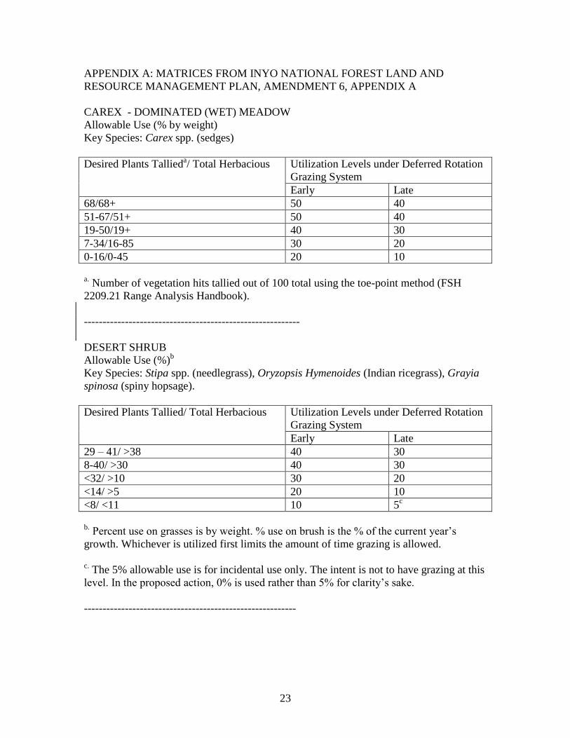
APPENDIX A: MATRICES FROM INYO NATIONAL FOREST LAND AND
RESOURCE MANAGEMENT PLAN, AMENDMENT 6, APPENDIX A
CAREX - DOMINATED (WET) MEADOW
Allowable Use (% by weight)
Key Species: Carex spp. (sedges)
Desired Plants Tallieda/ Total Herbacious Utilization Levels under Deferred Rotation
Grazing System
Early Late
68/68+ 50 40
51-67/51+ 50 40
19-50/19+ 40 30
7-34/16-85 30 20
0-16/0-45 20 10
a. Number of vegetation hits tallied out of 100 total using the toe-point method (FSH
2209.21 Range Analysis Handbook).
----------------------------------------------------------
DESERT SHRUB
Allowable Use (%)b
Key Species: Stipa spp. (needlegrass), Oryzopsis Hymenoides (Indian ricegrass), Grayia
spinosa (spiny hopsage).
Desired Plants Tallied/ Total Herbacious Utilization Levels under Deferred Rotation
Grazing System
Early Late
29 – 41/ >38 40 30
8-40/ >30 40 30
<32/ >10 30 20
<14/ >5 20 10
<8/ <11 10 5c
b.
Percent use on grasses is by weight. % use on brush is the % of the current year’s
growth. Whichever is utilized first limits the amount of time grazing is allowed.
c. The 5% allowable use is for incidental use only. The intent is not to have grazing at this
level. In the proposed action, 0% is used rather than 5% for clarity’s sake.
---------------------------------------------------------
24
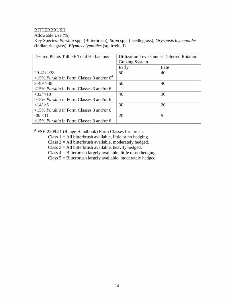
BITTERBRUSH
Allowable Use (%)
Key Species: Purshia spp. (Bitterbrush), Stipa spp. (needlegrass), Oryzopsis hymenoides
(Indian ricegrass), Elymus elymoides (squirreltail).
Desired Plants Tallied/ Total Herbacious Utilization Levels under Deferred Rotation
Grazing System
Early Late
29-41/ >38
<15% Purshia in Form Classes 3 and/or 6d
50 40
8-40/ >30
<15% Purshia in Form Classes 3 and/or 6
50 40
<32/ >10
>15% Purshia in Form Classes 3 and/or 6
40 30
<14/ >5
>15% Purshia in Form Classes 3 and/or 6
30 20
<8/ <11
>15% Purshia in Form Classes 3 and/or 6
20 5
d.
FSH 2209.21 (Range Handbook) Form Classes for brush.
Class 1 = All bitterbrush available, little or no hedging.
Class 2 = All bitterbrush available, moderately hedged.
Class 3 = All bitterbrush available, heavily hedged.
Class 4 = Bitterbrush largely available, little or no hedging.
Class 5 = Bitterbrush largely available, moderately hedged.
25
APPENDIX B: MAPS
26
27
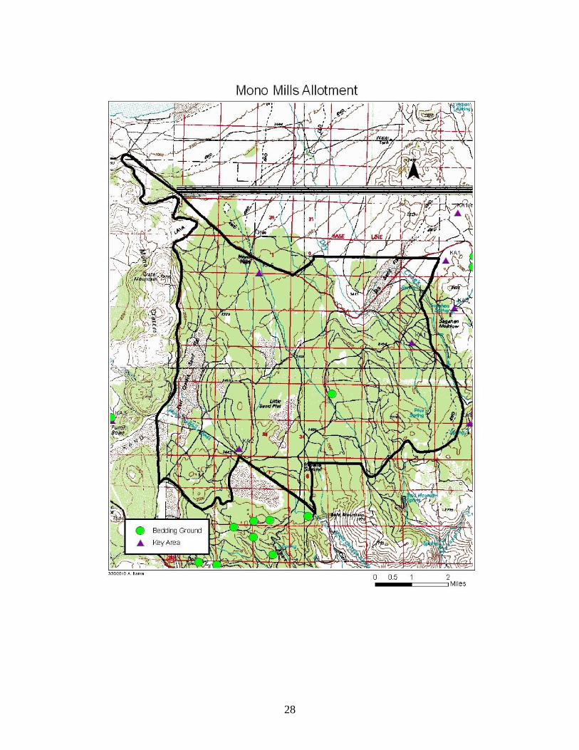
28
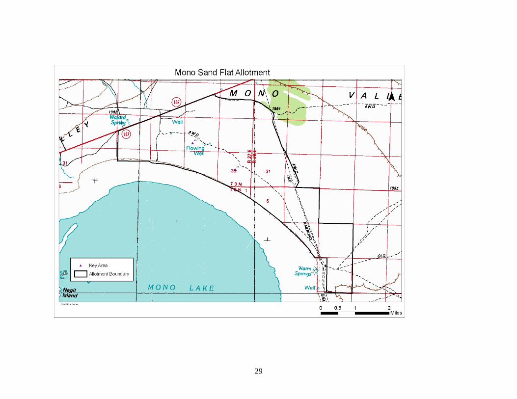
29