Mohamed I. Sultan - Western Michigan University · Tamer El Bayoumi (2013- 2014) Western Michigan...
21
Mohamed I. Sultan Mohamed Sultan, Professor and Chair Office: 269 387-5487; Department of Geosciences Lab: 269 387-5513 Western Michigan University email: [email protected] 1185 Rood Hall Web page: http://www.esrs.wmich.edu/ Kalamazoo, MI 49008-5241 U.S.A. Education Washington University, St. Louis, MO Remote Sensing Post Doc. 1985-1988 Washington University, St. Louis, MO Geochemistry Ph.D. 1984 Ain Shams University, Cairo, Egypt Stratigraphy M.Sc. 1978 Ain Shams University, Cairo, Egypt Geology B.Sc. 1974 Work History 2004-present Professor and Chair – Department of Geosciences, Western Michigan University 2004-present Director – Earth Sciences Remote Sensing facility, Western Michigan University 2011-present Chair – Michigan Geological Survey, Michigan, USA 2002-2004 Professor – Department of Geology, University at Buffalo, Amherst, NY. 1996-2002 Project Manager, International Programs – Environmental Research Division, Argonne National Laboratory, Argonne, IL. 1988-1996 Senior Research Scientist – National Aeronautics and Space Administration (NASA) Earth and Planetary Remote Sensing Facility, Department of Earth and Planetary Sciences, McDonnell Center for the Space Sciences, Washington University, St. Louis, MO. 1984-1988 Research Associate – Department of Earth and Planetary Sciences, Washington University, St. Louis, MO. Honors, Awards Fellow Geological Society America, GSA Annual Meeting (2009- present) Farouk El-Baz Award for Desert Research, Quaternary Geology and Geomorphology Division, Geological Society of America (1999) Member of NASA GRACE Science Team (2009- present) Associate Editor – Geological Society America, Bulletin (2004-2007) Research Professor – Department of Geology, University at Buffalo, Amherst, NY (2004-2007). Adjunct Associate Professor – Department of Earth and Environmental Sciences, University of Illinois, Chicago, IL (1997-present) Adjunct Full Professor – Department of Geophysics, Cairo University, Giza, Egypt (1996-2007) Adjunct Full Professor – Department of Geology, Ain Shams University, Cairo, Egypt (2000-present) Fellow, McDonnell Center for the Space Sciences, Washington University, St. Louis, MO (1988-1996) Current Support Sultan, M., Principal Investigator, An integrated approach for a better understanding of the hydrologic setting, longevity, and optimum utilization of the Nubian Sandstone Aquifer System in Egypt (National Academy of Sciences)(2016-2019; $168,143). Sultan, M., Principal Investigator ,Use of GRACE and Relevant Remote Sensing Data to Estimate Spatial and Temporal Changes in Terrestrial Water Storage over the Nubian Sandstone Aquifer System, (National Authority for Remote Sensing & Space Sciences; NARSS)(2016; $27,000) Sultan, M., Principal Investigator, Use of Grace, remote Sensing, and traditional data sets for modeling time-dependent water partitioning on continental scales: A case study from Africa, (NASA- GRACE)(2011-2017; $522,000). Sultan, M., Principal Investigator, Development of an early warning system for rainfall-induced debris flows (Saudi Geological Survey)(2015-2016; $100,000).
Transcript of Mohamed I. Sultan - Western Michigan University · Tamer El Bayoumi (2013- 2014) Western Michigan...
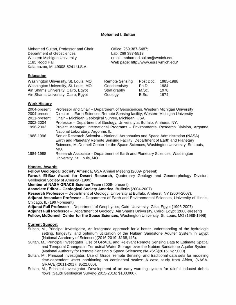
Mohamed I. Sultan Mohamed Sultan, Professor and Chair Office: 269 387-5487; Department of Geosciences Lab: 269 387-5513 Western Michigan University email: [email protected] 1185 Rood Hall Web page: http://www.esrs.wmich.edu/ Kalamazoo, MI 49008-5241 U.S.A.
Education Washington University, St. Louis, MO Remote Sensing Post Doc. 1985-1988 Washington University, St. Louis, MO Geochemistry Ph.D. 1984 Ain Shams University, Cairo, Egypt Stratigraphy M.Sc. 1978 Ain Shams University, Cairo, Egypt Geology B.Sc. 1974
Work History 2004-present Professor and Chair – Department of Geosciences, Western Michigan University 2004-present Director – Earth Sciences Remote Sensing facility, Western Michigan University 2011-present Chair – Michigan Geological Survey, Michigan, USA 2002-2004 Professor – Department of Geology, University at Buffalo, Amherst, NY. 1996-2002 Project Manager, International Programs – Environmental Research Division, Argonne
National Laboratory, Argonne, IL. 1988-1996 Senior Research Scientist – National Aeronautics and Space Administration (NASA)
Earth and Planetary Remote Sensing Facility, Department of Earth and Planetary Sciences, McDonnell Center for the Space Sciences, Washington University, St. Louis, MO.
1984-1988 Research Associate – Department of Earth and Planetary Sciences, Washington University, St. Louis, MO.
Honors, Awards Fellow Geological Society America, GSA Annual Meeting (2009- present) Farouk El-Baz Award for Desert Research, Quaternary Geology and Geomorphology Division, Geological Society of America (1999) Member of NASA GRACE Science Team (2009- present) Associate Editor – Geological Society America, Bulletin (2004-2007) Research Professor – Department of Geology, University at Buffalo, Amherst, NY (2004-2007). Adjunct Associate Professor – Department of Earth and Environmental Sciences, University of Illinois, Chicago, IL (1997-present) Adjunct Full Professor – Department of Geophysics, Cairo University, Giza, Egypt (1996-2007) Adjunct Full Professor – Department of Geology, Ain Shams University, Cairo, Egypt (2000-present) Fellow, McDonnell Center for the Space Sciences, Washington University, St. Louis, MO (1988-1996) Current Support Sultan, M., Principal Investigator, An integrated approach for a better understanding of the hydrologic
setting, longevity, and optimum utilization of the Nubian Sandstone Aquifer System in Egypt (National Academy of Sciences)(2016-2019; $168,143).
Sultan, M., Principal Investigator ,Use of GRACE and Relevant Remote Sensing Data to Estimate Spatial and Temporal Changes in Terrestrial Water Storage over the Nubian Sandstone Aquifer System, (National Authority for Remote Sensing & Space Sciences; NARSS)(2016; $27,000)
Sultan, M., Principal Investigator, Use of Grace, remote Sensing, and traditional data sets for modeling time-dependent water partitioning on continental scales: A case study from Africa, (NASA- GRACE)(2011-2017; $522,000).
Sultan, M., Principal Investigator, Development of an early warning system for rainfall-induced debris flows (Saudi Geological Survey)(2015-2016; $100,000).
2
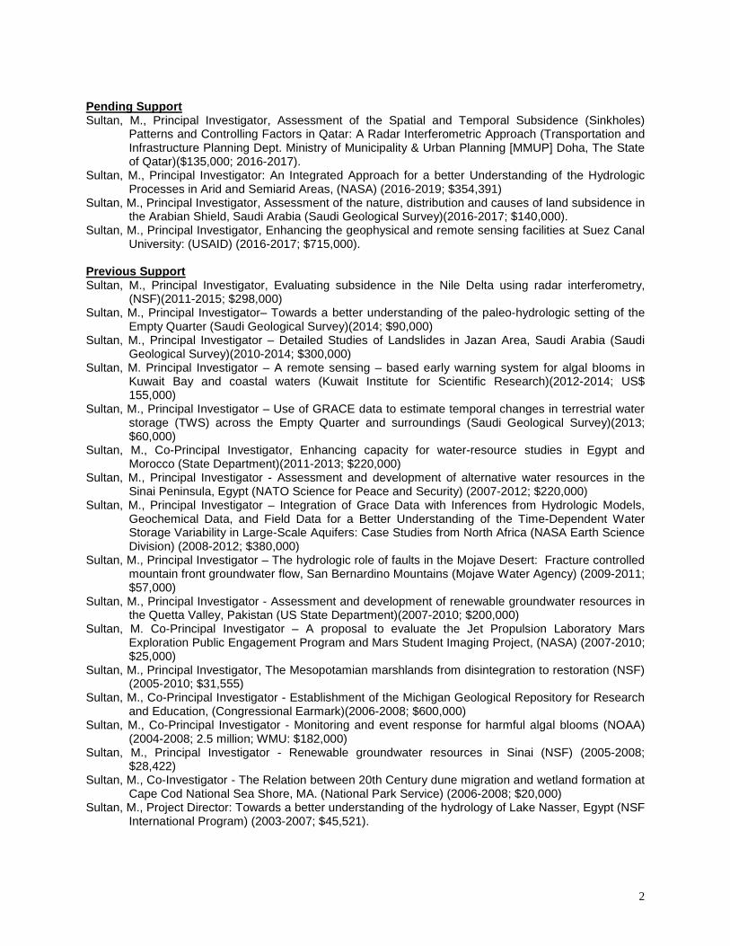
Pending Support Sultan, M., Principal Investigator, Assessment of the Spatial and Temporal Subsidence (Sinkholes)
Patterns and Controlling Factors in Qatar: A Radar Interferometric Approach (Transportation and Infrastructure Planning Dept. Ministry of Municipality & Urban Planning [MMUP] Doha, The State of Qatar)($135,000; 2016-2017).
Sultan, M., Principal Investigator: An Integrated Approach for a better Understanding of the Hydrologic Processes in Arid and Semiarid Areas, (NASA) (2016-2019; $354,391)
Sultan, M., Principal Investigator, Assessment of the nature, distribution and causes of land subsidence in the Arabian Shield, Saudi Arabia (Saudi Geological Survey)(2016-2017; $140,000).
Sultan, M., Principal Investigator, Enhancing the geophysical and remote sensing facilities at Suez Canal University: (USAID) (2016-2017; $715,000).
Previous Support Sultan, M., Principal Investigator, Evaluating subsidence in the Nile Delta using radar interferometry,
(NSF)(2011-2015; $298,000) Sultan, M., Principal Investigator– Towards a better understanding of the paleo-hydrologic setting of the
Empty Quarter (Saudi Geological Survey)(2014; $90,000) Sultan, M., Principal Investigator – Detailed Studies of Landslides in Jazan Area, Saudi Arabia (Saudi
Geological Survey)(2010-2014; $300,000) Sultan, M. Principal Investigator – A remote sensing – based early warning system for algal blooms in
Kuwait Bay and coastal waters (Kuwait Institute for Scientific Research)(2012-2014; US$ 155,000)
Sultan, M., Principal Investigator – Use of GRACE data to estimate temporal changes in terrestrial water storage (TWS) across the Empty Quarter and surroundings (Saudi Geological Survey)(2013; $60,000)
Sultan, M., Co-Principal Investigator, Enhancing capacity for water-resource studies in Egypt and Morocco (State Department)(2011-2013; $220,000)
Sultan, M., Principal Investigator - Assessment and development of alternative water resources in the Sinai Peninsula, Egypt (NATO Science for Peace and Security) (2007-2012; $220,000)
Sultan, M., Principal Investigator – Integration of Grace Data with Inferences from Hydrologic Models, Geochemical Data, and Field Data for a Better Understanding of the Time-Dependent Water Storage Variability in Large-Scale Aquifers: Case Studies from North Africa (NASA Earth Science Division) (2008-2012; $380,000)
Sultan, M., Principal Investigator – The hydrologic role of faults in the Mojave Desert: Fracture controlled mountain front groundwater flow, San Bernardino Mountains (Mojave Water Agency) (2009-2011; $57,000)
Sultan, M., Principal Investigator - Assessment and development of renewable groundwater resources in the Quetta Valley, Pakistan (US State Department)(2007-2010; $200,000)
Sultan, M. Co-Principal Investigator – A proposal to evaluate the Jet Propulsion Laboratory Mars Exploration Public Engagement Program and Mars Student Imaging Project, (NASA) (2007-2010; $25,000)
Sultan, M., Principal Investigator, The Mesopotamian marshlands from disintegration to restoration (NSF) (2005-2010; $31,555)
Sultan, M., Co-Principal Investigator - Establishment of the Michigan Geological Repository for Research and Education, (Congressional Earmark)(2006-2008; $600,000)
Sultan, M., Co-Principal Investigator - Monitoring and event response for harmful algal blooms (NOAA) (2004-2008; 2.5 million; WMU: $182,000)
Sultan, M., Principal Investigator - Renewable groundwater resources in Sinai (NSF) (2005-2008; $28,422)
Sultan, M., Co-Investigator - The Relation between 20th Century dune migration and wetland formation at Cape Cod National Sea Shore, MA. (National Park Service) (2006-2008; $20,000)
Sultan, M., Project Director: Towards a better understanding of the hydrology of Lake Nasser, Egypt (NSF International Program) (2003-2007; $45,521).

3
Sultan, M., Principal Investigator: Developing renewable ground water resources in arid lands: A Pilot Case – The Eastern Desert of Egypt (Global Environmental Facility; United Nations Development Program [UNDP]) (2003-2007; Total: $880,000; UB: $250,331).
Sultan, M., Principal Investigator: A Web-Based GIS for Egypt’s geological datasets (NSF) (2003-2007; Total: $59,736; WMU: $29,754).
Sultan, M., Project Director: REU support - Towards a Better understanding of the hydrology of Lake Nasser, Egypt (NSF) (2004-2007; $6,500)
Sultan, M., Principal Investigator: REU support - A Web-Based GIS for Egypt’s geological datasets (NSF) (2004-2007; $3000)
Sultan, M., Co- Investigator, Town of Amherst soil and structural stability study: Technical, planning, and engineering assistance (US Army Corps of Engineers) (2004-2005; $68,000) (administered by UB)
Sultan, M., Principal Investigator: Integrated Hydrology of the Nubian Aquifer: Evidence from Radar and SRTM data (European Space Agency) (2004-2005; $18000)
Sultan, M., Co-Project Director: Collaborative Research: A GIS Database for Studying and Visualizing Tethyan Plate Collisions (National Science Foundation [NSF]) (2003-2006; Total: $398,979; UB: $102,073)
Sultan, M., Co-Investigator: Environmental Assessment of Natural Radioactivity and Heavy Metal Pollution in the El Fayoum Area, Egypt (U.S. Environmental Protection Agency) (2002-2005; $45,000) (administered by UIC).
Sultan, M., Principal Investigator: Assessment, Monitoring, and Modeling of Changes in Land Use and Land Cover and Their Impacts on the Nubian Aquifer, Saharan Africa (NASA – Carbon Cycle Science and Related Opportunities in Biology and Biogeochemistry of Ecosystems and Applications) (2001-2005; Total: $518,337).
Sultan, M., Co-Principal Investigator: Training of Cairo University (CU) Faculty on Environmental Issues (U.S. Agency for International Development-CU) (2002-2003; $90,000) (administered by UIC).
Sultan, M., Co-Investigator: Water Cycle Observations, Analysis, and Modeling (DOE) (2001-2002; $1,500,000 total; $100,000 for my research).
Sultan, M., Principal Investigator: Hydrogeologic and Environmental Impacts of the New Valley Project, U.S. Department of Agriculture (USDA)/Egyptian Ministry of International Cooperation. Project involved the development of the Center for Environmental Science and Technology (1999-2001; Total Budget: $602,058; U.S. allocation: $240,823).
Sultan, M., U.S. Principal Investigator: CU Center for Environmental Hazard Assessment. Funded by USDA (1995-2002; Total budget [CU and Argonne]: $3 million; U.S. allocation: $881,765).
Sultan, M., Principal Investigator: Application of Fundamental Science to Critical Environmental Issues. (Argonne LDRD Strategic Initiatives) (1998-2000; $185,000).
Sultan, M., Co-Principal Investigator: Paleoclimatic Studies of the Western Desert, Egypt. (NASA Geology Program) (1995-1997).
Sultan, M., Principal Investigator: Tectono-Thermal History of Pre-Pan African Crust in NE Africa: Inferences from Field, Geochronologic, and Isotopic Data. (NSF) (1993-1997).
Sultan, M., Co-Investigator: SIR-C Studies of the Precambrian Hamisana and Nakasib Structures, NE Sudan, in Arid Regions of Low Relief and in the Subsurface. (NASA Geology Program) (1988-1994).
Sultan, M., Co-Principal Investigator: Paleoclimatic and Tectonic History of the Eastern Desert, Egypt, and Surroundings. (NASA Geology Program) (1991-1994)
Sultan, M., Principal Investigator: Geologic Correlations across the Atlantic using Landsat and Gravity Data. (EOSAT) (1993-1994).
Sultan, M., Co-Principal Investigator: Workshop on the Assembly of Gondwana. (NSF, Continental Dynamics Program) (1993-1994).
Sultan, M., Co-Investigator; Arvidson, R.E., Principal Investigator: Toward Global Perspectives on Continental Tectonics. (NASA Geology Program) (1988-1991).
Sultan, M., Co- Investigator: Integration of Landsat, Field, and Geochronological Data in Search for the Oldest Continental Crust within Accreted Terranes in the Eastern Desert, Egypt. (NASA Innovative Research Program) (1988-1990).
Sultan, M., Principal Investigator: Production of Lithologic and Structural Maps from Digital Landsat Thematic Mapper Data over the Eastern Desert, Egypt. (NSF) (1989-1991).
4
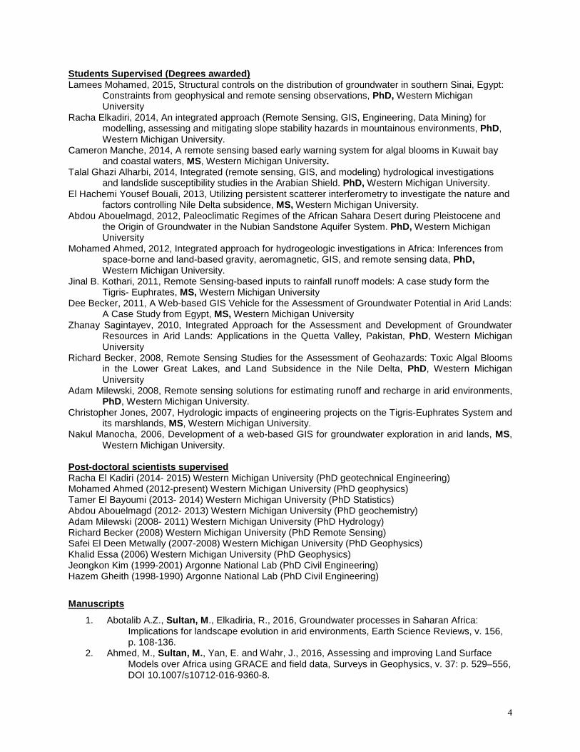
Students Supervised (Degrees awarded) Lamees Mohamed, 2015, Structural controls on the distribution of groundwater in southern Sinai, Egypt:
Constraints from geophysical and remote sensing observations, PhD, Western Michigan University
Racha Elkadiri, 2014, An integrated approach (Remote Sensing, GIS, Engineering, Data Mining) for modelling, assessing and mitigating slope stability hazards in mountainous environments, PhD, Western Michigan University.
Cameron Manche, 2014, A remote sensing based early warning system for algal blooms in Kuwait bay and coastal waters, MS, Western Michigan University.
Talal Ghazi Alharbi, 2014, Integrated (remote sensing, GIS, and modeling) hydrological investigations and landslide susceptibility studies in the Arabian Shield. PhD, Western Michigan University.
El Hachemi Yousef Bouali, 2013, Utilizing persistent scatterer interferometry to investigate the nature and factors controlling Nile Delta subsidence, MS, Western Michigan University.
Abdou Abouelmagd, 2012, Paleoclimatic Regimes of the African Sahara Desert during Pleistocene and the Origin of Groundwater in the Nubian Sandstone Aquifer System. PhD, Western Michigan University
Mohamed Ahmed, 2012, Integrated approach for hydrogeologic investigations in Africa: Inferences from space-borne and land-based gravity, aeromagnetic, GIS, and remote sensing data, PhD, Western Michigan University.
Jinal B. Kothari, 2011, Remote Sensing-based inputs to rainfall runoff models: A case study form the Tigris- Euphrates, MS, Western Michigan University
Dee Becker, 2011, A Web-based GIS Vehicle for the Assessment of Groundwater Potential in Arid Lands: A Case Study from Egypt, MS, Western Michigan University
Zhanay Sagintayev, 2010, Integrated Approach for the Assessment and Development of Groundwater Resources in Arid Lands: Applications in the Quetta Valley, Pakistan, PhD, Western Michigan University
Richard Becker, 2008, Remote Sensing Studies for the Assessment of Geohazards: Toxic Algal Blooms in the Lower Great Lakes, and Land Subsidence in the Nile Delta, PhD, Western Michigan University
Adam Milewski, 2008, Remote sensing solutions for estimating runoff and recharge in arid environments, PhD, Western Michigan University.
Christopher Jones, 2007, Hydrologic impacts of engineering projects on the Tigris-Euphrates System and its marshlands, MS, Western Michigan University.
Nakul Manocha, 2006, Development of a web-based GIS for groundwater exploration in arid lands, MS, Western Michigan University.
Post-doctoral scientists supervised Racha El Kadiri (2014- 2015) Western Michigan University (PhD geotechnical Engineering) Mohamed Ahmed (2012-present) Western Michigan University (PhD geophysics) Tamer El Bayoumi (2013- 2014) Western Michigan University (PhD Statistics) Abdou Abouelmagd (2012- 2013) Western Michigan University (PhD geochemistry) Adam Milewski (2008- 2011) Western Michigan University (PhD Hydrology) Richard Becker (2008) Western Michigan University (PhD Remote Sensing) Safei El Deen Metwally (2007-2008) Western Michigan University (PhD Geophysics) Khalid Essa (2006) Western Michigan University (PhD Geophysics) Jeongkon Kim (1999-2001) Argonne National Lab (PhD Civil Engineering) Hazem Gheith (1998-1990) Argonne National Lab (PhD Civil Engineering)
Manuscripts
1. Abotalib A.Z., Sultan, M., Elkadiria, R., 2016, Groundwater processes in Saharan Africa: Implications for landscape evolution in arid environments, Earth Science Reviews, v. 156, p. 108-136.
2. Ahmed, M., Sultan, M., Yan, E. and Wahr, J., 2016, Assessing and improving Land Surface Models over Africa using GRACE and field data, Surveys in Geophysics, v. 37: p. 529–556, DOI 10.1007/s10712-016-9360-8.
5
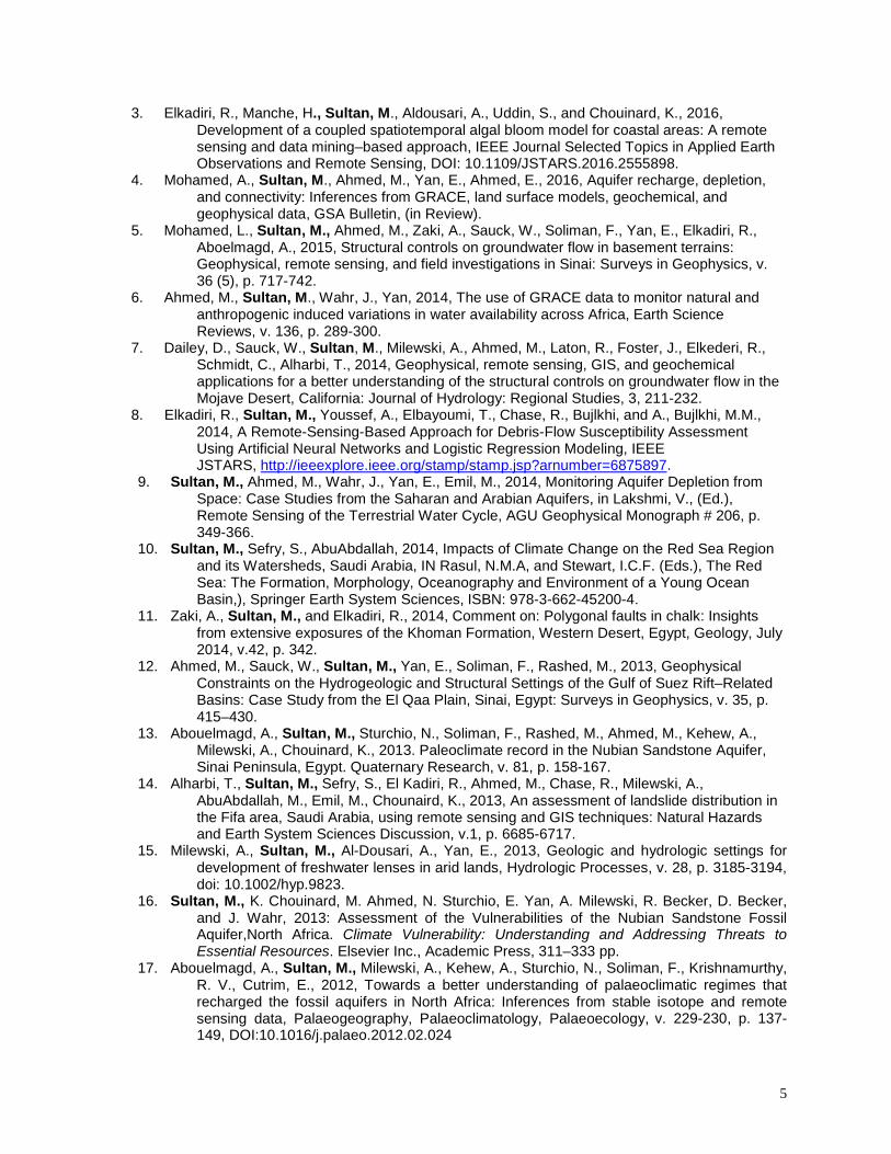
3. Elkadiri, R., Manche, H., Sultan, M., Aldousari, A., Uddin, S., and Chouinard, K., 2016, Development of a coupled spatiotemporal algal bloom model for coastal areas: A remote sensing and data mining–based approach, IEEE Journal Selected Topics in Applied Earth Observations and Remote Sensing, DOI: 10.1109/JSTARS.2016.2555898.
4. Mohamed, A., Sultan, M., Ahmed, M., Yan, E., Ahmed, E., 2016, Aquifer recharge, depletion, and connectivity: Inferences from GRACE, land surface models, geochemical, and geophysical data, GSA Bulletin, (in Review).
5. Mohamed, L., Sultan, M., Ahmed, M., Zaki, A., Sauck, W., Soliman, F., Yan, E., Elkadiri, R., Aboelmagd, A., 2015, Structural controls on groundwater flow in basement terrains: Geophysical, remote sensing, and field investigations in Sinai: Surveys in Geophysics, v. 36 (5), p. 717-742.
6. Ahmed, M., Sultan, M., Wahr, J., Yan, 2014, The use of GRACE data to monitor natural and anthropogenic induced variations in water availability across Africa, Earth Science Reviews, v. 136, p. 289-300.
7. Dailey, D., Sauck, W., Sultan, M., Milewski, A., Ahmed, M., Laton, R., Foster, J., Elkederi, R., Schmidt, C., Alharbi, T., 2014, Geophysical, remote sensing, GIS, and geochemical applications for a better understanding of the structural controls on groundwater flow in the Mojave Desert, California: Journal of Hydrology: Regional Studies, 3, 211-232.
8. Elkadiri, R., Sultan, M., Youssef, A., Elbayoumi, T., Chase, R., Bujlkhi, and A., Bujlkhi, M.M., 2014, A Remote-Sensing-Based Approach for Debris-Flow Susceptibility Assessment Using Artificial Neural Networks and Logistic Regression Modeling, IEEE JSTARS, http://ieeexplore.ieee.org/stamp/stamp.jsp?arnumber=6875897.
9. Sultan, M., Ahmed, M., Wahr, J., Yan, E., Emil, M., 2014, Monitoring Aquifer Depletion from Space: Case Studies from the Saharan and Arabian Aquifers, in Lakshmi, V., (Ed.), Remote Sensing of the Terrestrial Water Cycle, AGU Geophysical Monograph # 206, p. 349-366.
10. Sultan, M., Sefry, S., AbuAbdallah, 2014, Impacts of Climate Change on the Red Sea Region and its Watersheds, Saudi Arabia, IN Rasul, N.M.A, and Stewart, I.C.F. (Eds.), The Red Sea: The Formation, Morphology, Oceanography and Environment of a Young Ocean Basin,), Springer Earth System Sciences, ISBN: 978-3-662-45200-4.
11. Zaki, A., Sultan, M., and Elkadiri, R., 2014, Comment on: Polygonal faults in chalk: Insights from extensive exposures of the Khoman Formation, Western Desert, Egypt, Geology, July 2014, v.42, p. 342.
12. Ahmed, M., Sauck, W., Sultan, M., Yan, E., Soliman, F., Rashed, M., 2013, Geophysical Constraints on the Hydrogeologic and Structural Settings of the Gulf of Suez Rift–Related Basins: Case Study from the El Qaa Plain, Sinai, Egypt: Surveys in Geophysics, v. 35, p. 415–430.
13. Abouelmagd, A., Sultan, M., Sturchio, N., Soliman, F., Rashed, M., Ahmed, M., Kehew, A., Milewski, A., Chouinard, K., 2013. Paleoclimate record in the Nubian Sandstone Aquifer, Sinai Peninsula, Egypt. Quaternary Research, v. 81, p. 158-167.
14. Alharbi, T., Sultan, M., Sefry, S., El Kadiri, R., Ahmed, M., Chase, R., Milewski, A., AbuAbdallah, M., Emil, M., Chounaird, K., 2013, An assessment of landslide distribution in the Fifa area, Saudi Arabia, using remote sensing and GIS techniques: Natural Hazards and Earth System Sciences Discussion, v.1, p. 6685-6717.
15. Milewski, A., Sultan, M., Al-Dousari, A., Yan, E., 2013, Geologic and hydrologic settings for development of freshwater lenses in arid lands, Hydrologic Processes, v. 28, p. 3185-3194, doi: 10.1002/hyp.9823.
16. Sultan, M., K. Chouinard, M. Ahmed, N. Sturchio, E. Yan, A. Milewski, R. Becker, D. Becker, and J. Wahr, 2013: Assessment of the Vulnerabilities of the Nubian Sandstone Fossil Aquifer,North Africa. Climate Vulnerability: Understanding and Addressing Threats to Essential Resources. Elsevier Inc., Academic Press, 311–333 pp.
17. Abouelmagd, A., Sultan, M., Milewski, A., Kehew, A., Sturchio, N., Soliman, F., Krishnamurthy, R. V., Cutrim, E., 2012, Towards a better understanding of palaeoclimatic regimes that recharged the fossil aquifers in North Africa: Inferences from stable isotope and remote sensing data, Palaeogeography, Palaeoclimatology, Palaeoecology, v. 229-230, p. 137-149, DOI:10.1016/j.palaeo.2012.02.024
6
18. Becker, D., Sultan, M., Milewski, A., Becker, R., Sauck, W., Soliman, F., Rashed, M., Yan, E., Wagdy, A., Ahmed, M., Chouinard, K., Welton, B., 2012, Integrated Solutions for Hydrologic Investigations in Arid Lands, Geosphere, v. 8, p. 1588-1605.
19. Ahmed, M., Sultan, M., Wahr, J., Yan, E., Milewski, A., Sauck, W., Becker, R., Welton, B., 2011, Integration of GRACE data with traditional datasets for a better understanding of the time-dependent water partitioning in African watersheds, Geology, DOI:10.1130/G31698.1
20. Sagintayev, Z., Sultan, M., Khan, SD, Khan, SA, Mahmood, K., Yan, E., Milewski, A., Marsala, P., 2011, A Remote Sensing Contribution to Hydrologic Modeling in Arid and Inaccessible Watersheds, Pishin Lora Basin, Pakistan, J. Hydrological Processes, DOI: 10.1002/hyp.8114
21. Sultan, M., Metwally, S., Milewski, A, Becker, D., Ahmed, M., Sauck, W., Soliman, F., Sturchio, N., Wagdi, A., Becker, R., and Benjamin, S., 2011, Modern Recharge to the Nubian Aquifer, Sinai Peninsula: Geochemical, Geophysical, and Modeling Constraints, J. Hydrology, V. 403, p 14-24, doi:10.1016/j.jhydrol.2011.03.036.
22. Sultan, M., Fawzy, A., Metwally, S., Becker, R., Milewski, A., Sauck, W., Sturchio, N. C., Mohamed, A.M.M., Wagdy, A., El Alfy, Z., Becker, D., Sagintayev, Z., El Sayed, M., and Welton, B., 2011, Red Sea rifting controls on aquifer distribution: constraints from geophysical, isotopic, and remote sensing data, Geological Society America Bulletin, v. 123; p. 911-924; DOI: 10.1130/B30146.1.
23. Becker, R. H., and Sultan, M., 2009, Land Subsidence in the Nile Delta: Inferences from Radar Interferometry, Holocene, vol 19, no. 6, p. 1-6.
24. Becker, R.H., Sultan, M., Boyer, G.L., Twiss, M.R., and Konopko, E., 2009, Mapping cyanbacterial blooms in the Great Lakes using MODIS, Journal Great Lakes Research, v. 35, no 3, p. 447-453.
25. Khan, S. D., Mahmood, K., Sultan, M., Khan, A. S., Xiong, Y., Sagintayev, Z., 2010. Trace element geochemistry of groundwater from Quetta Valley, western Pakistan. Journal of Environmental Earth Sciences, 60, 573-582.
26. Milewski, A., Sultan, M., Eugene, Y., Abdeldayem, A., and Abdel Gelil, K., 2009, A Remote Sensing Solution for Estimating Runoff and Recharge in Arid Environments, Journal of Hydrology, v. 373, p. 1-14, v. 35, p. 2001-2010.
27. Milewski, A., Sultan, M., Markondiah Jayaprakash, S., Balekai, R., and Becker, R. (2009b), RESDEM, a Tool for Integrating Temporal Remote Sensing Data for use in Hydrogeologic Investigations, Journal of Computers and Geosciences, v. 35, p. 2001-2010.
28. El-Sayed M. Abdelrahman, Essa, K.S., Abo-Ezz, E.R., Sultan, M., Sauck, W.A., and Gharieb, A.G., 2008, New least-squares algorithm for model parameters estimation using self-potential anomalies, Computers and Geosciences, v. 34, p. 1569-15767.
29. Forman, S., Sagintayev, Z., Sultan, M., Smith, S., Kendall, M., Marin, L., and Becker, R., 2008, The migration of parabolic dunes and wetland formation at Cape Cod National Sea Shore, MA: Landscape response to a legacy of human disturbance, Holocene, v. 18, no 5, p. 765-774.
30. Jones, C., Sultan, M., Yan, E., Milewski, A., Hussein, M., Al-Dousari, A., Al-Kaisy, S., Becker, R., 2008, Hydrologic Impacts of Engineering Projects on the Tigris-Euphrates System and its Marshlands, Journal of Hydrology, v. 353, p. 59-75 (doi:10.1016/j.jhydrol.2008.01.029).
31. Sultan, M., Sturchio, N., El Sefry, S., Milewski, A., Becker, R., Nasr, I., 2008, Geochemical, Isotopic, and Modeling Constraints on the Origin and Evolution of the Rub Al Khali Groundwater Aquifer System, Arabian Peninsula, Journal of Hydrology, v. 356, p. 70– 83.
32. Sultan, M., Wagdy, A., Manocha, N., Sauck, W., Abdel Gelil, K., Youssef, A.F., Becker, R., Milewski, A., Jones, C., 2008, An Integrated Approach for Identifying Aquifers in Transcurrent Fault Systems: The Najd Shear System of the Arabian Nubian Shield v. 349(3-4), p 475-488. doi:10.1016/j.jhydrol.2007.11.029.
33. Sultan, M., Yan, E., Sturchio, N., Wagdy, A., Abdel Gelil, K., Manocha, N., Becker, R., Milewski, A., 2007, Natural Discharge: A Key to Sustainable Utilization of Fossil Groundwater, Journal of Hydrology, v. 335, p. 25-36.
34. Becker, R., Sultan, M., Boyer, G., and Konopko, E., 2006, Mapping Variations Of Algal Blooms In The Lower Great Lakes, Great Lakes Research Review, V7, p. 14-17.
7
35. Milewski, A., Sultan, M., Wagdy, A., Abdel Gelil, K., 2006, Regional Prospective for Continuous Rainfall-Runoff-Recharge Estimation Using SWAT Model, Proceedings of Third Arab Water Regional Conference, Cairo, Egypt, Dec 9 – 11 2006.
36. Sultan, M., Flower, M, Sandvol, E, Manocha, N, Markondiahjayaprakash, S., Becker, R, Jones, C., Milewski, A., 2006, Web-based GIS: The Tethys Database, Proceedings for Workshop on Remote Sensing and GIS: Techniques and Applications, Kuwait City, Kuwait, 25-29 November, 2006.
37. Sultan, M., Wagdy, A., Manocha, N., Abdel Gelil, K., Becker, R, 2006, Development and Applications of Replicable and Cost-effective Methodologies for Groundwater Assessment and Exploration, Proceedings of Third Arab Water Regional Conference, Cairo, Egypt, Dec 9 – 11 2006.
38. Sultan, M., Wagdy, A., Manocha, N., Becker, R, Milewski, A., 2006, Applications of Remote Sensing and GIS in Ground water Exploration, Proceedings for Workshop on Remote Sensing and GIS: Techniques and Applications, Kuwait City, Kuwait, 25-29 November, 2006.
39. Atkinson, J., Sultan, M., Becker, R., and Boyer, G., Monitoring Algal Blooms in the Great Lakes, 2005, Proceedings of the 8th International Conference on Remote Sensing for Marine and Coastal Environments, Halifax, Nova Scotia, Canada, 17-19 May, 2005.
40. Becker, R., Sultan, M., Atkinson, J, Boyer, G, Konopko, E, Spatial and Temporal Variations of Algal Blooms in the Lower Great Lakes, 2005, Proceedings of the 8th International Conference on Remote Sensing for Marine and Coastal Environments, Halifax, Nova Scotia, Canada, 17-19 May, 2005.
41. Khan, S.D., Flower, M.F.J, Sultan, M., and Sandvol, E., 2005, Introduction to TETHYS – an interdisciplinary GIS database for studying continental collision, Journal of Asian Earth Sciences, v. 26, iss. 6, pp. 613-625.
42. Patterson L. J., Sturchio N. C., Kennedy B. M., van Soest M.C., Sultan, M., Lu Z.T., Lehmann B. E., Purtschert R., El Kaliouby B., Dawood Y., and Abdallah A.M, 2005, Cosmogenic, radiogenic, and stable isotopic constraints on groundwater residence time in the Nubian Aquifer, Western Desert of Egypt, Geochem. Geophys. Geosyst . 6(1), Q01005, doi:10.1029/2004GC000779.
43. Sturchio, N.C., Du, X., Purtschert, R., Lehmann, B.E., Sultan, M., Patterson, L.T., Lu, Z.-T., Müller, P., Bigler, T., Bailey, K., O’Connor, T.P., Young, L., Lorenzo, R., Becker, R., El Alfy, Z., El Kaliouby, B. Dawood, Y., and Abdallah, A.M.A., 2004, One million year old groundwater in the Sahara revealed by krypton-81 and chlorine-36, Geophysical Research Letters, v. 31, No. 5.
44. Sturchio, N.C., Patterson, L.J, Sultan, M., Lu, Z.-T., Purtschert, R., Lehmann, B.E., El Alfy, Z., El Kaliouby, B., Dawood, Y., and Abdallah, A.M.A., Residence time of Nubian Aquifer groundwater determined from cosmogenic isotopes, Proceedings of the Workshop for Integration of Remote Sensing (RS) and Geographic Information Systems (GIS) Technology for Assessing and Managing Surface and Ground Water in Egypt, December 3-9, 2003,Cairo, Egypt.
45. Sultan, M., Becker, R., Al-Dousari, A., Al-Ghadban, A.N., Bufano, E., 2003, Water, Agriculture and Land Cover: Lessons for the Postwar Era. Geotimes, v. 48, no. 10, pp. 22-24.
46. Sultan, M., Yan,E., Ballerstein, E., Becker, R., Towards a better understanding of the hydrology of Lake Nasser, Proceedings of the Workshop for Integration of Remote Sensing (RS) and Geographic Information Systems (GIS) Technology for Assessing and Managing Surface and Ground Water in Egypt, December 3-9, 2003,Cairo, Egypt.
47. Sultan, M., Gheith, H., Sturchio, N.C., and El Alfy, Z., 2003, Origin and recharge rates of alluvial groundwater, Eastern Desert, Egypt, Proceedings of the International Conference on Water Resources Management in Arid Regions (WaRMAR), v. 5, pp. 121-134, March 23-27, Kuwait City, Kuwait.
48. Sultan, M., Becker, R., Al-Dousari, A., Al-Ghadban, A., and Bufano, E., 2003, Water, agriculture, and landcover: Lessons for the post-war era, Geotimes, October issue, p. 22-25.
8
49. Gheith, H., and Sultan, M., 2002, Construction of a hydrology model for estimating wadi runoff and groundwater recharge in the Eastern Desert, Egypt, Journal of Hydrology, v. 263, pp. 36-55.
50. Kim, J., and Sultan, M., 2002, Assessment of the long-term hydrologic impacts of Lake Nasser and related irrigation projects in southwestern Egypt, Journal of Hydrology, v. 262, pp. 68-83.
51. Miller, N.L., Miller, M.A., Springer, E.P., Wesely, M.L., King, A.W., Bashford, K.E., Conrad, M.S., Costigan, K.R., Depaolo, D.J., Fung, I., Kemball-Cook, S., Klazura, G.E., Lesht, B.M., Troyan, D.T., Machavaram, M., Sultan, M., Song, J., and Washington-Allen, R., 2001, Modeling and Analysis of the water cycle seasonal and event variability at the Walnut River Watershed, 16th Conference on Hydrology, American Meteorological Society, 13-17 January 2002, Orlando, FL.
52. El Araby, H., and Sultan, M., 2000, Integrated seismic risk map of Egypt, Seismological Research Letters, v. 71, pp. 52-65.
53. Sultan, M., Sturchio, N.C., Abdel Hady, Y., and El Anbaawy, M., 2000, Chemical and isotopic constraints on the origin Wadi El-Tarfa groundwaters, Eastern Desert, Egypt, Ground Water, v. 38, pp. 743-751.
54. Gheith, H., and Sultan, M., 2001, Assessment of the renewable groundwater resources of Wadi El-Arish, Sinai, Egypt: Modeling, remote sensing and GIS applications, in M. Owe et al., Proceedings of a Symposium on Remote Sensing and Hydrology 2000, IAHS publication no. 267, pp. 451-454.
55. Crombie, M.K., Gillies, R.R., Arvidson, R.E., Brookmeyer, P., Weil, G.J., Sultan, M., and Harb, M., 1999, An application of remotely derived climatological fields for risk assessment of vector-borne diseases: A spatial study of filariasis prevalence in the Nile Delta, Egypt, Photogrammetric Engineering and Remote Sensing, v. 65, no. 12, pp. 1401-1410.
56. Doskey, P., Fukui, Y., Sultan, M., El Maghraby, A., and Taher, A., 1999, Source profiles for non-methane organic compounds in the atmosphere of Cairo, Egypt, Journal of Air and Waste Management Association, v. 49, pp. 814-822.
57. Sturchio, N.C., Sultan, M., El Sharkawy, M., El Alfy, Z., Taher, A., El Maghraby, A., and El Anbaawy, M., 1999, Origin of groundwaters in the newly reclaimed agricultural lands, western Nile Delta, Egypt: Preliminary isotopic results, in A.M.A. Hafez et al., Proceedings of the 4th Annual Conference on the Geology of the Arab World, v. 2, pp. 1094-1098.
58. Sultan, M., Fiske, M., Stein, T., Gamal, M., Abdel Hady, Y., El Araby, H., El Araby, T., Madani, A., Mehanee, S., and Becker, R., 1999, Satellite-based monitoring of urbanization in the Nile Delta, Egypt, Ambio, v. 28, pp. 628-631.
59. Sultan, M., Sturchio, N.C., Abdel Hady, Y., El Anbeawy, M., and El Bahar, O., 1999, Preserving Nile water resources and ecosystems through the use of alternative renewable groundwater resources: A pilot case – the Eastern Desert of Egypt, Proceedings, Second International Conference and Trade Fair on Environmental Management and Technologies, Cairo, Egypt, Egyptian Environmental Affairs Agency, pp. 703-712.
60. Abdelsalam, M., Sultan, M., and others, 1997, Geodynamic Map of Gondwana, 4 sheets, 1:10,000,000, Bureau de Recherches Geologiques et Minieres, Orleans, France.
61. Sultan, M., Sturchio, N., Hassan, F.A., Hamdan, M.A.R., Mahmood, A.M., El Alfy, Z., and Stein, T., 1997, Precipitation source inferred from stable isotopic composition of Pleistocene groundwater and carbonate deposits in the Western Desert of Egypt, Quaternary Geology, v. 4, pp. 29-37.
62. Lou, W., Arvidson, R.E., Sultan, M., Becker, R., Crombie, M.K., Sturchio, N.C., and El Alfy, Z., 1997, Groundwater sapping processes, Western Desert, Egypt, Geological Society of America Bulletin, v. 109, pp. 43-62.
63. Sultan, M., Stein, T., Abdel Hady, Y., El Araby, H., El Araby, T., Madani, A., and Mehany S., 1997, Monitoring thirty years of urbanization and sea-shoreline erosion, Nile Delta, Egypt, Proceedings, First International Conference and Trade Fair on Environmental Management and Technologies, Cairo, Egypt, Egyptian Environmental Affairs Agency.
64. Sturchio, N.C., Sultan, M., Arehart, G.B., Sano, Y., Kamar, Y.A., and Sayed, M., 1996, Composition and origin of thermal waters in the Gulf of Suez area, Egypt, Applied Geochemistry, v. 11, pp. 471-479.
9
65. Sultan, M., Sturchio, N., Hassan, F.A., Hamdan, M.A.R., Mahmood, A.M., El Alfy, Z., and Stein, T., 1996, New constraints on the Quaternary paleoclimate of North Africa, 1997, Proceedings, Centennial Meeting for the Egyptian Geological Survey and Mining Authority, Cairo, Egypt, pp. 809-820.
66. Abdelsalam, M.G., Stern, R.J., Schandelmeier, H., Sultan, M., 1995, Deformational history of the Neoproterozoic Keraf Zone, NE Sudan revealed by Shuttle imaging radar, Journal of Geology, v. 103, pp. 475-491.
67. Rogers, J., Unrug, R., and Sultan, M., 1995, Tectonic assembly of Gondwana, Geodynamics, v. 19, pp. 1-34.
68. Sultan, M., Tucker, R.D., El Alfy, Z., Attia, R., 1994, U-Pb (zircon) ages for the gneissic terrane west of the Nile, southern Egypt, Geologisch Rundschau, v. 83, pp. 514-522.
69. Schandelmeier, H., Wipfler, E., Kuster, D., Sultan, M., Becker, R., Stern, R.J., and Abdelsalam, M.G., 1993, The Atmur-Delgo suture: a Neoproterozoic oceanic basin extending into the interior of North Africa, Geology, v. 22, pp. 563-566.
70. Arvidson, R.E., Becker, R., Shanabrook, A., Luo, W., Sturchio, N., Sultan, M., Lotfy, Z., Mahmood, A.M., and El Alfy, Z., 1993, Eustatic sea level and tectonic controls on Quaternary landscapes, Red Sea coast, Eastern Desert, Egypt, Proceedings, Chapman Conference on Topography and Tectonics: Journal of Geophysical Research, v. 99, pp. 12,175-12,190.
71. Arvidson, R.E., Duncan, I.J., Green, G.M., Rivard, B., and Sultan, M., 1993, Geological mapping using Landsat Thematic Mapper data over oak-hickory forest, arctic, and hyperarid terrains, in K. Pieters and P.A.J. Englert (eds.), Remote Geochemical Analyses: Elemental and Mineralogical Composition, Cambridge University Press, pp. 247-282.
72. Sultan, M., Becker, R., Arvidson, R.E., Shore, P., Stern, R.J., El Alfy, Z., and Attia, R.I., 1993, New constraints on Red Sea rifting from correlations of Arabian and Nubian Neoproterozoic outcrops, Tectonics, v. 12, pp. 1303-1319.
73. Sultan, M., Becker, R., Arvidson, R.E., Shore, P., Stern, R.J., and Guinness, E.A., 1993, Reply to Comment by W. Bosworth on the nature of the Red Sea crust: A controversy revisited? Geology, v. 21, pp. 575-576.
74. Rivard, B., Arvidson, R.E., Duncan, I.J., Sultan, M., and El Kaliouby, B., 1992, Varnish, sediment, and rock controls on spectral reflectance of outcrops in arid regions, Geology, v. 20, p. 295-298.
75. Sultan, M., Bickford, M.E., El Kaliouby, B., and Arvidson, R.E., 1992, Common Pb systematics of Precambrian granitic rocks of the Nubian Shield and tectonic implications, Geological Society of America Bulletin, v. 104, pp. 456-470.
76. Sultan, M., Becker, R., Arvidson, R.E., Shore, P., Stern, R.J., El Alfy, Z., and Guinness, E.A., 1992, The nature of the Red Sea crust: A controversy revisited? Geology, v. 20, pp. 593-596.
77. Stern, R.J., Sultan, M., and Abdel-Salam, M.G., 1992, Comment – Pacific margins of Laurentia and East Antarctica-Australia as a conjugate rift pair: Evidence and implications for an Eocambrian supercontinent, Geology, v. 20, pp. 190.
78. Sultan, M., Duncan, I.J., Arvidson, R.E., Stern, R.J., and El Kaliouby, B., 1990, Reply – Extension of the Najd Shear System from Saudi Arabia to the central Eastern Desert of Egypt based on integrated field and Landsat observations, Tectonics, v. 9, pp. 539-543.
79. Duncan, I.J., Rivard, B., Arvidson, R.E., and Sultan, M., 1990, Structural interpretation of shear zones utilizing Landsat Thematic Mapper data: A case study from the Najd Fault System, Arabian-Nubian Shield, Tectonophysics, v. 178, pp. 309-335.
80. Stern, R.J., Nielsen, K.C., Best, E., Sultan, M., Arvidson, R.E., and Kroner, A., 1990, On the orientation of late Precambrian sutures in the Arabo-Nubian Shield, Geology, v. 18, pp. 1103-1106.
81. Sultan, M., Arvidson, R.E., Duncan, I.J., Stern, R.J., and El Kaliouby, B., 1988, Extension of the Najd Shear System from Saudi Arabia to the central Eastern Desert of Egypt based on integrated field and Landsat observations, Tectonics, v. 7, pp. 1291-1306.
82. Sultan, M., Arvidson, R.E., Sturchio, N.C., and Guinness, E., 1987, Lithologic mapping in arid regions with Landsat Thematic Mapper data: Meatiq Dome, Egypt, Geologic Society of America Bulletin, v. 99, pp. 748-762.
10
83. Sultan, M., Arvidson, R.E., and Sturchio, N.C., 1987, Reply – Mapping of serpentinites in the Eastern Desert of Egypt Using Landsat Thematic Mapper, Geology, pp. 874-875.
84. Sultan, M., Arvidson, R.E., and Sturchio, N.C., 1986, Mapping of serpentinites in the Eastern Desert of Egypt Using Landsat Thematic Mapper data, Geology, v. 14, pp. 995-999.
85. Sultan, M., Batiza, R., and Sturchio, N.C., 1986,The origin of small-scale geochemical and mineralogic variations in a granite intrusion: A crystallization and mixing model, Contributions to Mineralogy and Petrology, v. 93, pp. 513-523.
86. Green, G., Arvidson, R., Sultan, M., and Guinness E.A., 1985, Geobotanical information contained in Landsat Thematic Mapper images covering southern Missouri, Proceedings, Fourth Thematic Conference, Remote Sensing in Exploration Geology, Univ. Mich. Press, pp. 371-380.
87. Sturchio, N., Sultan, M., and Batiza, R., 1983, Geology and origin of Meatiq Dome, Egypt: A Precambrian metamorphic core complex? Geology, v. 11, pp. 72-76.
88. Sturchio, N., Sultan, M., Sylvester, P., Batiza, R., Hedge, C., El Shazly, E.M., and Abdel-Maguid, A., 1983, Geology, age and origin of the Meatiq Dome: Implications for the Precambrian stratigraphy and tectonic evolution of the Eastern Desert of Egypt, Bulletin Faculty of Earth Science, King Abdulaziz Univ., v. 6, pp. 127-143.
Abstracts for Presentations (talks/posters) at Professional Meetings 1. Sultan, M., Becker, R., Gebremichael, E., Emil, M., Ahmed, M., Elkadiri, R., Pankratz, H.,
Chouinard, K., 2015, Applications of Radar Interferometric Techniques to Assess Natural Hazards and their Controlling Factors. AGU, San Francisco, California, December, 2015.
2. Othman, A., Sultan, M., Ahmed, M., Alharbi, T., Gebremichael, E., Emil, M., 2015, An Integrated Approach for the Assessment of the Natural and Anthropogenic Controls on Land Subsidence in the Kingdom of Saudi Arabia. AGU, San Francisco, California, December, 2015.
3. Mohamed, L., Sultan, M., Ahmed, M., Abotalib, A.Z., 2015, Fault zone hydrogeology of crystalline and sedimentary aquifers in arid regions: The case Sinai Peninsula, Egypt. AGU, San Francisco, California, December, 2015.
4. Elkadiri, R., Sultan, M., Elbayoumi, T., Chouinard, K., 2015, Forecasting Precipitation over the MENA Region: A Data Mining and Remote Sensing Based Approach. AGU, San Francisco, California, December, 2015.
5. Pankratz, H., Sultan, M., Elkadiri, R., Almogren, S., Gebremichael, E., Ahmed, M., Emil, M., 2015, Integrated Approach for the Assessment of Land Deformation in the Jazan City and Surroundings, Saudi Arabia. AGU, San Francisco, California, December, 2015.
6. Ahmed, M., Sultan, M., 2015. Monitoring temporal variations in water resources across the Arabian Peninsula and identification of their controlling factors. AGU, San Francisco, California, December, 2015.
7. Abotalib, A.Z., Sultan, M., Forman, S., Krishnamurthy, R.V. 2015, Origin, age, and paleoclimatic setting of the Late Quaternary deposits in Wadi Feiran, Sinai Peninsula: Geomorphologic, geochronologic, and isotopic constraints. AGU, San Francisco, California, December, 2015.
8. Emil, M., Sultan, M., Abotalib, A.Z. Abouelmagd, A., Ahmed, M., 2015, Timing and Nature of Wet Climatic Periods in North Africa and in the Arabian Peninsula: Inferences from Isotopic, Chronologic, and Remote sensing data. AGU, San Francisco, California, December, 2015.
9. Mohamed, A., Sultan, M., Yan, E., Ahmed, E., Sturchio, N., 2015, Towards a better understanding of the hydrologic setting of the nubian sandstone aquifer system: inferences from groundwater flow models, cl-36 ages, and grace data. AGU, San Francisco, California, December, 2015.
10. Gebremichael, E., Sultan, M., Becker, R., Emil, M., Ahmed, M., Chouinard, K., 2015, Use of Persistent Scatterer Interferometry to Assess Land Deformation in the Nile Delta and its Controlling Factors. AGU, San Francisco, California, December, 2015.
11. Sultan, M., Emil, M., Abotalib, Z.A., Abouelmagd, A., AlZahrani, A., Refai, A., AlQathamy, K., Alaamry, M., Bahamil, A., 2015. Nature and timing of the quaternary wet climatic periods in north africa and arabia: isotopic, chronologic, and remote sensing constraints. GSA, Baltimore, MY, 2015.

11
12. Abotalib, Z.A., Sultan, M., Elkadiri, R., Heggy, E., Saad, A., 2015, Origin of theater-headed valleys in the sahara: implication for outflow channels on Mars. GSA, Baltimore, MY, 2015.
13. Sultan, M., 2015, Egypt’s Water Resources, Present and Future, 2015, 8th International Conference on the Geology of the Middle East, Ain Shams University, Cairo Egypt, March 29-30 2015.
14. Sultan, M., 2005, Use of GRACE data to monitor Saharan and Sub-Saharan hydrologic systems, 2015, Groundwater Regional Workshop, Tunis City Center, Tunisia, April 6-8, 2015.
15. Sultan, M., 2015, Integration of RS with traditional data sources and modelling to assess groundwater potential in arid terrains: Case studies from Egypt, 2015, Groundwater Regional Workshop, Tunis City Center, Tunisia, April 6-8, 2015.
16. Sultan, M., Ahmed, M., 2015, Use of GRACE and Land Surface Models to Monitor Water Availability in Central Asia and Surroundings, 2014, 4th International Seminar on Human Being and Ecological Environment of Central Asia, 2-6th February 2015, Xinjiang University, China.
17. Mohamed, A., Sultan, M., Ahmed, M., Yan, E., 2014. Quantifying modern recharge to the Nubian Sandstone Aquifer System: inferences from GRACE and Land Surface Models. AGU, San Francisco, California, December, 2014.
18. Othman, A. Sultan, M., Alharbi, H., Youssif, A., Ahmed, M., Emil, M., Zabramwi, Y., Alzahrani, S., Bahmil, A., Chouinard, K., 2014. Assessment of the nature, distribution and causes of land subsidence in Central and Northern Saudi Arabia. AGU, San Francisco, California, December, 2014.
19. Abouelmagd, A., McCabe, M., Castro, C., Sultan, M., Jana, R., Al-Mashharawi, S., 2014, Recharge regimes of the Saq aquifer system, Saudi Arabia: Inferences from geochemical and isotopic compositions, AGU, San Francisco, California, December, 2014.
20. Sultan, M., Ahmed, M., Yan, E., Milewski, A., Mohamed, L., Farag, A., 2014. Management of Egypt’s Surface and Groundwater Resources: Present and Future. AGU, San Francisco, CA, December, 2014.
21. Emil, M., Sultan, M., Ahmed, M., Chouniard, K., 2014. Understanding the paleohydrological setting of the Arabian Peninsula: An integrated approach. AGU, San Francisco, California, December, 2014.
22. Manche, C., Sultan, M., El Kadiri, R., Uddin, S., Al-Dousari, A., Chouinard, K., 2014. Controls on Algal Bloom Propagation in the Kuwait Bay Utilizing: An Integrated Remote Sensing and Statistical Approach. AGU, San Francisco, California. Fall Meeting, December, 2014.
23. Alharbi, T., Sultan, M., Ahmed, M., Chouniard, K., 2014. Assessment of climate vulnerabilities of the Arabian Peninsula. AGU, San Francisco, California, December, 2014.
24. Ahmed, M., Sultan, M., Wahr, J., Yan, E., 2014. Monitoring natural and anthropogenic induced variations in water availability across Africa. AGU, San Francisco, California, December, 2014.
25. Abotalib, Z., Sultan, M., El Kadiri, R., Abdelhalim, A., 2014. Did Groundwater Processes Shape the Saharan Landscape during the Previous Wet Periods? A Remote Sensing and Geostatistical Approach. AGU, San Francisco, California, December, 2014.
26. Mohamed, L., Sultan, M., Abotalib, Z., 2014. Structural Control of Groundwater flow in The Sinai Peninsula: Integrated Studies. AGU, San Francisco, California, December, 2014.
27. Mohamed, A., Sultan, M., Bakheit, A., Ezzat, A., Ahmed, M., Farag, a., 2014. Geophysical (global gravity field model) and field (well data) Constraints on Groundwater Flow in the Nubian Sandstone Aquifer in Egypt, Sudan, Libya, and Chad. GSA, Vancouver, BC, October 2014.
28. Sultan, M., Ahmed, M., Milewski, A., Becker, R., Yan, E., Sturchio, N., Mohamed, L., Farag, A., Becker D, Chouinard, K., 2014. Integrated approaches for sustainable utilization of water resources in Arid Lands: Case Studies from Egypt. GSA, Vancouver, BC, October 2014.
29. Ahmed, M., Sultan, M., Wahr, J., Yan, E., 2014. Evaluating the Performance of Land Surface Models Using GRACE Data over Africa. GSA, Vancouver, BC, October 2014.
30. Ahmed, M., Sultan, M., Wahr, J., Mohamed, A., Yan, E., 2014. Quantifying recharge and depletion rates of the Nubian Sandstone Aquifer System: An integrated approach. GRACE Science Team Meeting (GSTM), Potsdam, Germany, September – October 2014.
12
31. Sultan, M., Ahmed, M., Wahr, J., Yan, E., 2014. Assessing the performance of land surface models over Africa using GRACE and remote sensing data. GRACE Science Team Meeting (GSTM), Potsdam, Germany, September – October 2014.
32. Qian, S., Tiyip, T., Sultan, M., Ahmed, M., 2014, Monitoring of dynamic changes in terrestrial water storage in Central Asia using GRACE data: The 3rd International Workshop on Earth Observation and Remote Sensing Applications (EORSA), Changsha, China, 2014.
33. Ahmed, M., Sultan, M., Wahr, J., Yan, E., 2013, Monitoring Aquifer Depletion from Space: Case Studies from the Saharan and Arabian Aquifers: AGU, San Francisco, CA, Dec. 2013
34. Mohamed, L., Sultan, M., Ahmed, M., Zaki, A., 2013, An integrated approach (remote sensing, geophysics, field) to assess the structural control of groundwater flow in Wadi Feiran basement complex, Sinai-Egypt: AGU, San Francisco, CA, Dec. 2013
35. Sultan, M., Sturchio, N., Sefry, S., Ahmed, M., AbuAbdallah, M., Emil, M., Chouinard, K., 2013, Chemical, Isotopic and Remote Sensing Constraints on the Age, Origin, and Groundwater Potentiality in the Rub Al Khali Aquifer System, Arabian Peninsula: AGU, San Francisco, CA, Dec. 2013
36. Alharbi, T., Sultan M., Ahmed, M., Sefry, S., AbuAbdallah, 2013, Modeling Runoff and Sediments Yields and their Response to Climate Change: Case Study from the Red Sea Coast of Saudi Arabia: AGU, San Francisco, CA, Dec. 2013
37. Emil, M., Sultan M., Sefry, S., Ahmed, M., AbuAbdallah, Chouinard, K., Krawczyk, M., 2013, Reconstruction of the paleohydrological setting of the Rub Al Khali, Saudi Arabia: AGU, San Francisco, CA, Dec. 2013
38. Ahmed, M., Sultan, M., Wahr, J., Yan, E., 2013, Is the Nubian Sandstone Aquifer System Being Depleted: GSA, Denver, CO, Oct. 2013
39. Sultan, M., Abouelmagd, A., Ahmed, M., Sturchio, N., Krishnamurthy, R., Soliman, F., Rashed, M., Milewski, A., Krawczyk, M., 2013, Constraints on the timing of recharge of the fossil aquifers in Saharan Africa and Sinai: GSA, Denver, CO, Oct. 2013
40. El Kadiri, R., Sultan, M., Becker, R., Krawczyk, M., Al Harbi, T., Chouinard, K., 2013. Statistical and Remote Sensing based Approach to Determine Debris Flows Triggering Factors. Geological Society of America. North-Central Section, 2-3 May.
41. Mohamed, L., Sultan, M., Zaki, A., 2013. Structural Control of Groundwater Flow, Southern Sinai, Egypt: Remote Sensing Constraints. Geological Society of America. North-Central Section, 2-3 May.
42. Zaki, A., Mohamed, L., Sultan, M., 2013. Investigating the Physical Environment of Gebel El-Hamza Area, NE Cairo, Egypt: A Remote Sensing Approach. Geological Society of America. North-Central Section, 2-3 May.
43. Ahmed, M., Sultan, M., Alharbi, T., 2013. Monitoring Aquifer Depletion from Space: Case Studies from Nubian Sandstone Aquifer in Egypt and the Saq Aquifer in Saudi Arabia. Geological Society of America. North-Central Section, 2-3 May.
44. Manche, C., Sultan, M., Becker, R., Chouinard, K., Tinigin, L., 2013. Integrated Approach to Better Determining Algal Blooms in Case II waters in the Kuwait Bay: A Remote Sensing Based Approach. Geological Society of America. North-Central Section, 2-3 May.
45. Alharbi, T., Sultan, M., Ahmed, M., 2013. Climate Change over the Arabian Peninsula: Inferences from TRMM Data. Geological Society of America. North-Central Section, 2-3 May.
46. Bouali, E.H., Sultan, M., Becker, R., Chouinard, K., 2013. Subsidence of the Nile Delta, Egypt: Optimizing Interferometric Synthetic Aperture Radar (Insar) Results over Urban Centers in Vegetated Regions. Geological Society of America. North-Central Section, 2-3 May.
47. Abouelmagd, A., Sultan, M., Ahmed, M.E., Elbayoumi, T.M., and Chouinard, K., 2012. Impact of Low-Frequency Atmospheric Circulation Patterns (NAOI and EATP) on the spatial and temporal precipitation over North Africa. Abstract H21H-1290 presented at 2012 Fall Meeting, AGU, San Francisco, California, 3-7 December.
48. Ahmed, M.E., Sultan, M., Wahr, J.M., Yan, E., Bonin, J.A., and Chouinard, K., 2012. Monitoring climate and man-made induced variations in terrestrial water storage (TWS) across Africa using GRCAE data. Abstract G33A-0942 presented at 2012 Fall Meeting, AGU, San Francisco, California, 3-7 December.

13
49. Ahmed, M.E., Sultan, M., Wahr, J.M., Milewski, A., Chouinard, K., and Elbayoumi, T., 2012. The Use of GRACE and TRMM Data to Quantify the Spatial and Temporal Variations in Precipitation and Terrestrial Water Storage (TWS) Across the Nile River Basin. Geological Society of America Abstracts with Programs, Vol. 44, No. 7, p. 117.
50. Ahmed, M., Sauck, W., Sultan, M., Soliman, F., Rashed, M., 2012, Basin definition using gravity and magnetic data: Case study from El Qaa Plain, Sinai, Egypt: Symposium on the Application of Geophysics to Engineering and Environmental Problems (SAGEEP), Tucson, AZ, Mar. 2012.
51. Alharbi, T., Sultan, M., Elkadiri, R., Milewski, A., Ahmed, M.E., Emil, M., Chouinard, K., Krawczyk, M., Sefry, S., and Youssef, A., 2012. An Assessment of Landslides and Debris Flows Distribution in the Jazan Area, Saudi Arabia Using Remote Sensing and GIS Techniques. Geological Society of America Abstracts with Programs, Vol. 44, No. 7, p. 345.
52. Durham, M., Milewski, A., Sultan, M., and Elkadiri, R., 2012. Insight into Wadi Properties, Dynamics, and Interconnectedness during Flash-Flood Events using TRMM Satellite Data and Soil Temperature Probes in Sinai Peninsula, Egypt. Geological Society of America Abstracts with Programs, Vol. 44, No. 7, p. 117.
53. El Kadiri, R., Milewski, A., Sultan, M., Larabi, A., Ahmed, M., and Durham, M., 2012, SWAT modeling and remote sensing applications for the assessment of hydrologic responses to climatic changes in a Mediterranean Atlantic System, 39th International Association of Hydrogeologists (IAH) Congress, Niagara Fall, Ontario, Canada, Sept. 2012.
54. Laftouhi, N., Fekri, A., Benaabidate, L., Markhi, A., Zamrane, Z., Fryar, A.E., Milewski, A., and Sultan, M., 2012. The Integration of GIS and Remote Sensing in Training and Research in the Field of Water Resources Management in Morocco: Evolution and Benefits. Geological Society of America Abstracts with Programs, Vol. 44, No. 7, p. 116.
55. Sultan, M., Dailey, D.R., Sauck, W., Milewski, A., Laton, W.R., Foster, J.H., Eckhart, L., Garcia, A., and Chouinard, K., 2012. Geophysical and remote sensing applications for a better understanding of the structural (faults/basement uplifts) controls on groundwater flow in the Lucerne Valley, California. Abstract H41L-08 presented at 2012 Fall Meeting, AGU, San Francisco, California, 3-7 December.
56. Emil, M., Sultan, M., Fawzy, D.E., Ahmed, M.E., and Chouinard, K., 2012. Radar Interferometric Applications for a Better Understanding of the Distribution, Controlling Factors, and Precursors of Large Earthquakes in Turkey. Abstract NH41B-1611 presented at 2012 Fall Meeting, AGU, San Francisco, California, 3-7 December.
57. Mohamed, L., Sultan, M., Ahmed, M.E., Sauck, W., Abouelmagd, A., and Chouinard, K., 2012. Integrated approach (Geophysics and Remote Sensing) to identify water-bearing dyke swarms and fractured basement in the Sinai Peninsula, Egypt. Abstract H21H-1285 presented at 2012 Fall Meeting, AGU, San Francisco, California, 3-7 December.
58. Ahmed, M., Sauck, W., Sultan, M., Soliman, F., Rashed, M., 2012, Basin definition using gravity and magnetic data: Case study from El Qaa Plain, Sinai, Egypt: Symposium on the Application of Geophysics to Engineering and Environmental Problems (SAGEEP), Tucson, AZ, Mar. 2012
59. Ahmed, M., Sultan, M., Wahr, J., Yan, E., Milewski, A., Mohsen, F., Chouinard, K., 2011, Use of GRACE data to monitor climate change-induced variations in water storage availability in the African continent, American Geophysical Union Annual Meeting Abstracts with Programs, San Francisco, CA, Dec. 2011
60. Al Harbi, T., Sultan, M., El Kadiri, R., Ahmed, M., Sefry, S., Youssef, A., Beacker, R., Sandres, J., Chouinard, K., 2011, A Web-based GIS Approach for the Assessment of Landslides in the Jazan area, Saudi Arabia, American Geophysical Union Annual Meeting Abstracts with Programs, San Francisco, CA, Dec. 2011
61. Milewski, A., Sultan, M., Chouinard, K., Welton, B., Beacker, R., Ahmed, M., Beacker, D., 2011, Multi-scale Hydrogeologic applications using a web-based GIS server and custom geoprocessing tools, Geological Society of America Abstracts with Programs, Minneapolis, MN, Oct. 2011
62. El Kadiri, R., Milewski, A., Sultan, M., Beacker, R., Sefry, S., Youssef, A., Al Harbi, T., Ahmed, M., Sandres, J., Chouinard, K., 2011 Integrated methodologies (field, remote sensing, GIS) for the assessment of Landside Distribution, Hazards, and Controlling Factors in the Jizan

14
area, Saudi Arabia, Geological Society of America Abstracts with Programs, Minneapolis, MN, Oct. 2011
63. Sultan, M., Ahmed, M., Wahr, J., Yan, E., Milewski, A., Mohsen, F., Chouinard, K., 2011, The Use of GRACE Data to Identify Spatial and Temporal Trends in Water Storage Across Africa. GRACE Science Team Meeting (GSTM), Austin, TX, Aug. 2011
64. Abouelmagd, A., Sultan, M., Kehew, A., Milewski, A., and Sturchio, N., 2011. Source of Groundwater Recharge over the Nubian Sandstone Aquifer, Sinai Peninsula, Egypt: Geochemical and Geochronological Constraints. Abstract PP21A-1767 presented at 2011 Fall Meeting, AGU, San Francisco, California, 5-9 December.
65. Abouelmagd, A., Krishnamurthy, R.V., Sultan, M., Kehew, A., and Milewski, A., 2011. Paleoclimatic Insight into the Depleted Isotopic Ratios of Fossil Aquifer Waters, Northern Africa, Based on a Raleigh Distillation Model. Geological Society of America Abstracts with Programs, Vol. 43, No. 5, p 162.
66. Dailey, D., Sauck, W., Sultan, M., Milewski, A., Laton, W. R., Foster, J., Cadaret, E., 2010, Transcurrent Fault Systems in the Mojave Desert, Conduits or Barriers to Groundwater Flow, American Geophysical Union Annual Meeting Abstracts with Programs
67. Milewski, A., Sultan, M., Al-Dousari, A., 2010, Constraints on the Hydrologic Settings and Recharge of the Fresh water lenses in Kuwait, American Geophysical Union Annual Meeting Abstracts with Programs
68. Sagintayev, Z., Sultan, M., Khan, S.D., Khan, S.A., Mahmood, K., Yan, E., Milewski, A., Marsala, P., 2010, A Remote Sensing Contribution to Hydrologic Modeling in Arid and Inaccessible Watersheds, Pishin Lora Basin, Pakistan” , Annual Geological Society of America Abstracts with Programs.
69. Sultan, M., Metwally, S., Milewski, A., Becker,D., Ahmed, M., Sauck, W., Soliman, F., Sturchio, N., Yan, E., Rashed, M., Wagdy, A., Becker, R., and Welton, B., 2010, Modern Recharge of the Nubian Aquifer: Remote Sensing, Geochemical, Geophysical, and Modeling Constraints, American Geophysical Union Annual Meeting Abstracts with Programs
70. Al-Dousari, A., Sultan, M., and Milewski, A., 2009, Constraints on Groundwater Recharge in Arid Environments from Field, Remote Sensing Data and Rainfall–Runoff Models: Case Studies from Kuwait. GSA, Portland, Oregon, 18-21 October.
71. Becker, D.B., Milewski, A., Sultan, M., and Becker, R., 2009, A Web-based GIS vehicle for the Assessment of Groundwater Potential in Arid Lands: Case Studies from Eastern Desert of Egypt and the Sinai Peninsula. GSA, Portland, Oregon, 18-21 October.
72. Kothari, J., Sultan, M., Milewski, A., Balekai, R., andMarsala, P., 2009, Remote Sensing-based inputs to Rainfall Runoff Models: A Case Study from the Tigris-Euphrates Watershed. GSA, Portland, Oregon, 18-21 October.
73. Laton, R., Al Harbi, T., Sauck, W., Foster, J., Sultan, M., Milewski, A.,Marsala, P., Balekai, R., and Salim H., 2009, Use of Geophysical and Remote Sensing Data for a Better Understanding of the Hydrologic Role of Faults in the Mojave Desert. GSA, Portland, Oregon, 18-21 October.
74. Marsala, P., Ahmed, M.E., Sultan, M., Wahr, J., Milewski, A., Becker, R., Welton, B., and Balekai, R., 2009, Integration of GRACE Data with Inferences from Traditional Datasets for a Better Understanding of the Time-Dependent Water Storage Variability in Large-Scale Aquifers: Case Studies from Africa. GSA, Portland, Oregon, 18-21 October.
75. Milewski, A., Sultan, M., Metwally, S., Becker, D., Sauck, W., Soliman, F., Sturchio, N., Yan, E., Becker, R., and Zhanay, S., 2009, Modern Contributions to the Nubian Aquifer, Sinai Peninsula: Geochemical, Geophysical, and Modeling Constraints. GSA, Portland, Oregon, 18-21 October.
76. Sagintayev, Z., Sultan, M., Khan, S., Khan, A., Mahmood, K., Milewski, A.,Marsala, P., and Balekai, R., 2009, SWAT Modeling for the Pishin Lora Basin, Balochistan, Pakistan. GSA, Portland, Oregon, 18-21 October.
77. Sultan, M., Becker, R., Milewski, A., Sauck, W., Sturchio, N., Becker, D.B., Sagintayev, Z., and Ahmed, M.E., 2009. Red Sea Rifting Controls on Aquifer Distribution: Constraints from Geochemical, Geophysical, and Remote Sensing Data. GSA, Portland, Oregon, 18-21 October.

15
78. Sultan, M., Metwally, S., Milewski, A., Becker, D., Ahmed, M.E., Sauck, W., Soliman, F., Sturchio, N., Wagdi, A., Becker, R., Benjamin, W., 2009. Modern Contributions to the Nubian Aquifer, Sinai Peninsula: Geochemical, Geophysical, and Modeling Constraints. GSA, Portland, Oregon, 18-21 October.
79. Sultan, M., Safei El Den, M., Yousef, A.F., Milewski, A., Sturchio, N., Mahmoud, A.M.M., Becker, R., and Sagintayev, Z., 2008, Red Sea Rifting Controls on Groundwater Reservoir Distribution: Constraints from Geophysical, Isotopic, and Remote Sensing Data, Annual Geological Society of America Abstracts with Programs.
80. Sultan, M., Wahr, J., Ahmed, M., Milewski, A. and Becker, R., 2008, What is GRACE telling us about the hydrology of the Nubian Aquifer: GRACE Science Team Meeting (GSTM), Austin, TX, Dec. 2008.
81. Becker, R., and Sultan, M., 2008, Land Subsidence in the Northeastern Nile Delta as Measured by Radar Interfeometry, Annual Geological Society of America Abstracts with Programs.
82. Sagintayev, Z., Sultan, M., Khan, S., Mahmoud, A.S., Khan, A.S., Mahmoud, K., Becker, R., Milewski, A., and Welton, B., 2008, Groundwater Reservoir Types in Fold and Thrust Belts: Quetta Valley, Pakistan, Annual Geological Society of America Abstracts with Programs.
83. Sultan, M., Sturchio, N.C., Yan, E.g, Sefry, S., Milewski, A., Becker, R., Abdeldayem, A.W., and Nasr, I.M., 2007, Where and How Do We Find Groundwater in Arid Lands? An Integrated Approach from Egypt and Saudi Arabia, Annual Geological Society of America Abstracts with Programs.
84. Sturchio, N.C., Sultan, M.I., Patterson, L.J., Beloso, A.D., and Heraty, L.J., 2007, Groundwaters of the Eastern Desert of Egypt , Annual Geological Society of America Abstracts with Programs.
85. Milewski, A., Sultan, M., Balekai, R., Markondiah Jayaprakash, S., and Becker, R., 2007, RESDEM, A Vehicle For Data Mining and Modeling of Temporal Remote Sensing Data (TRMM, SSM/I, AVHRR, AMSR, MODIS, And QUICKSCAT), Annual Geological Society of America Abstracts with Programs.
86. Murray, K., Sagintayev, Z., Sultan, M., Khan, S., Becker, D., Becker, R., and Milewski, A., 2007, An Integrated Approach for the Assessment and Development of Renewable Groundwater Resources in the Quetta Valley, Pakistan, Annual Geological Society of America Abstracts with Programs.
87. Milewski, A.M., Markondiah, S., Sultan, M., Becker, R., 2006, Development of an automated precipitation processing model and applications in hydrologic investigations, Annual Meeting of the American Geophysical Union, California, San Francisco.
88. Yan, Y.E., Becker, R., Wagdy, A., and Sultan, M., 2004, Groundwater resources in the Assiuty hydrologic system of the Eastern Desert, Egypt, 2004 Geological Society of America Abstracts with Programs, Vol. 37.
89. Becker, R., Yan Y.E., Chowdhurry, A., and Sultan, M., 2004 Improving Regional Estimation of Renewable Resources for Sustainable Management, Geological Society of America Abstracts with Programs, Vol. 37.
90. Sandvol, C., Abbineni, T., Manjunath, D., Sandvol, E., Sultan, M., Flower, M., Danishwar, S., Becker, R., Milewski, A., Sidhardhan, G., Manocha, N., 2004, A GIS Earth Sciences Database for the Tethyan Mountain Belt, Mid-America GIs Consortium (MAGIC) symposium, Kansas City.
91. Sultan, M., and Becker, R, 2004, Monitoring Algal Blooms in inland Waters From Space-Borne Observation; A Case Study From Northern Africa, Lake Nasser, AGU Montreal.
92. Sultan, M., Manocha, N., Becker, R, and Sturchio, N.C., 2004, Paleodrainage Networks Recharging the Nubian Aquifer Dakhla and Kufra Sub-Basins Revealed From SIR-C and SRTM Data, AGU Montreal.
93. Sandvol, C., Abbineni, T., Manjunath, D., Sandvol, E., Sultan, M., Flower, M., Danishwar, S., Becker, R., Milewski, A., Sidhardhan, G., Manocha, N., 2004, A GIS Earth Sciences Database for the Tethyan Mountain Belt, Mid-America GIs Consortium (MAGIC) symposium, Kansas City.
94. Sturchio NC, Patterson LJ, Du X, Lu Z.T., Mueller P., Purtschert R., Lehmann B. E., Sultan, M., El Kaliouby B., Dawood Y. & Abdallah A.M., 2004. Krypton-81 and Water-Rock Interactions
16
on a Million-Year Time Scale (extended abstract). 11th International Symposium on Water-Rock Interactions, Saratoga Springs, NY, June 27-July 2, 2004.
95. Sultan, M., Sturchio, C., Becker, R., Manocha, N., Milewski, A., 2004, Paleodrainage networks of the Nubian Aquifer System revealed from SIR-C and SRTM data, Geological Society of America NE section Abstracts with Programs Vol. 36, No. 2.
96. Sultan, M., Flower, M., Sandvol, E., Danishwar, S, Becker, R., Sandvol, C., Milewski, A., Sidhardhan, G., Manocha, N, and Ballerstein, E, 2004, The Tethys Database: A Web-based GIS, Geological Society of America NE section Abstracts with Programs Vol. 36, No. 2.
97. Al Dousari, A., Sultan, M., Becker, R., and Bufano, E., 2003, Land cover and land use change (LCLUC) of the Mesopotamian marshes, Geological Society of America Annual Meeting Abstracts with Programs, vol. 35, no. 6.
98. Danishwar, S., Flower, M., Sandvol, E., and Sultan, M., 2003, Tethys: A GIS Database for Studying and Visualizing Tethyan Plate Collisions, Geological Society of America Annual Meeting Abstracts with Programs, vol. 35, no. 6.
99. Danishwar, S, Flower, M, Sandvol, E, and Sultan, M, 2003, Tethys: an ArcIMS prototype server for understanding plate collisions and geologic hazards", EGS-AGU-EUG Joint Assembly, Nice, France, April 2003.
100. Patterson, L.J., Sturchio, N.C., Sultan, M., Lu, Z.-T., Purtschert, R., Lehmann, B.E., El Alfy, Z., El Kaliouby, B., Dawood, Yehia H., and Abdallah, A.M.A., 2003, Chlorine isotopes, chloride sources, and residence times of groundwaters in the Nubian Aquifer, Egypt, Geological Society of America Annual Meeting Abstracts with Programs, vol. 35, no. 6.
101. Sturchio, N.C., Lu, Z.-T., Purtschert, R., Lehmann, B.E., Sultan, M., Du, X., Mueller, P., Lorenzo, R., El Alfy, Z., and El Kaliouby, B., 2003, Million-Year-Old Nubian Aquifer Groundwater Dated by Atom Counting of Krypton-81, Geological Society of America Annual Meeting Abstracts with Programs, vol. 35, no. 6.
102. Sultan, M., El Alfy, Z., Becker, R., Milewski, A., and Bufano, E., 2003, A Web-based GIS for Egypt's geologic datasets, Geological Society of America Annual Meeting Abstracts with Programs, vol. 35, no. 6.
103. Sultan, M., Flower, M., Becker, R., Milewski, A., Bufano, E., Sandvol, E., and Danishwar, S., 2003, A preliminary data set for the ‘Tethys’ database, Geological Society of America Annual Meeting Abstracts with Programs, vol. 35, no. 6.
104. Yan, E., Ballerstein, E., Sultan, M., and Becker, R., 2003, Hydrologic impacts of Lake Nasser and the Tushka lakes on the Nubian aquifer in SW Egypt, Geological Society America Annual Meeting Abstracts with Programs, vol. 35, no. 6.
105. Yan, E., Becker, R., Sultan, M., and Ballerstein, E., 2003, Development of the Tushka lakes in the southwestern desert of Egypt, Geological Society America Annual Meeting Abstracts with Programs, vol. 35, no. 6.
106. Sturchio, N.C., Sultan, M., Lu, Z.T., Du, X., Lehmann, B. E., Purtschert, R., Lorenzo, R., El Alfy, Z., and El-Kaliouby, B. 2002, Residence time of the Nubian aquifer water, Western Desert, Egypt, Goldschmidt Conference Abstracts, Geochim. Cosmochim. Acta, v. 66, A748.
107. Sultan, M., Becker, R., Jastrow, J.D., Miller, R.M., Kim, J., and El Alfy, Z., 2003, Land cover and land use changes and their impacts on groundwater resources and carbon cycling in SW Egypt, EOS Transactions, American Geophysical Union, vol. 83, p. 47.
108. Sultan, M., Becker, R., and Danishwar, S., 2002, Mapping suture zones from space, IGCP 430 2ND Annual Workshop: Mantle Responses to Tethyan Closure Abstracts with Programs, p. 57, April 1-5, 2002, Halong Bay City, Vietnam
109. Danishwar, S., Flower, M., and Sultan, M., 2002, Development of a GIS database web server facility for IGCP 430, IGCP 430 2ND Annual Workshop: Mantle Responses to Tethyan Closure Abstracts with Programs, p. 26, April 1-11, 2002, Halong Bay City, Vietnam
110. Miller, N.L., Miller, M.A., Springer, E.P., Wesely, M.L., King, A.W., Bashford, K.E., Conrad, M.S., Costigan, K.R., Depaolo, D.J., Fung, I., Kemball-Cook, S., Klazura, G.E., Lesht, B.M., Troyan, D.T., Machavaram, M., Sultan, M., Song, J., and Washington-Allen, R., 2001, Modeling and analysis of the water cycle seasonal and event variability at the Walnut River Watershed, 16th Conference on Hydrology, American Meteorological Society, 13-17 January 2002, Orlando, FL.

17
111. Miller, N.L., Miller, M.A., Springer, E.P., Wesely, M.L., King, A.W., Bashford, K.E., Conrad, M.S., Costigan, K.R., Depaolo, D.J., Fung, I., Kemball-Cook, S., Klazura, G.E., Lesht, B.M., Troyan, D.T., Machavaram, M., Sultan, M., Song, J., and Washington-Allen, R., 2001, Modeling and analysis of the water cycle: Seasonal and event variability at the Walnut River Watershed, American Geophysical Union 2001 Fall Meeting, December 10-14, 2001.
112. Danishwar, S., and Sultan, M., 2001, Interpretation of Aster remote sensing data on northwest Kohistan terrane, Pakistani Himalayas, Geological Society America Annual Meeting Abstracts with Programs, v. 33, p. A290.
113. Kim, J., Choi, H., and Sultan, M., 2001, In situ ozonation for vadose zone remediation: Transport characteristics and modeling, EOS Transactions, American Geophysical Union, vol. 82 (20), p. H32A-16.
114. Kim, J., and Sultan, M., 2001, Modeling the hydrologic impacts of the Tushka Canal project on the Nubian Aquifer (SW Egypt) and on the saltwater intrusion in the Nile Delta, Geological Society America Annual Meeting Abstracts with Programs, v. 33, p. A9.
115. Kim, J., Sultan, M., Criss, R., Salem, H., and Kassem, M., 2000, Hydrologic impacts of the Tushka Canal: Inferences from groundwater modeling and stable isotopic compositions of surface and groundwater samples, EOS Transactions, American Geophysical Union, vol. 821, p. 476.
116. Sultan, M., and El Araby, H., 2000, Seismic risks in Egypt, Abstract Book for the International Geological Correlation Program (IGCP 430), Mantle Dynamic Implications For Tethyan Natural Hazard Mitigation, Cosavana, Romania, June 16-22, 2000.
117. Gheith, H., and Sultan, M., 2000, Assessment of the renewable ground water resources of Sinai, Egypt, using remote sensing, digital terrain elevation, and meteorological data, Symposium of Remote Sensing and Hydrology 2000, International Commission on Remote Sensing for Hydrology, Santa Fe, NM.
118. Gheith, H., and Sultan, M., 1999, Preliminary assessment of the renewable ground water resources of the Eastern Desert, National Groundwater Annual Meeting Abstracts Book 1999, Nashville, TN, pp. 37-39.
119. Sultan, M., and El Araby, H., 1998, Integrated seismic risk map of Egypt, Geological Society America Annual Meeting, Abstracts with Programs, v. 30.
120. Doskey, P.V., Fukui, F.Y., Sultan, M., El Maghraby, A, and Taher, M., 1998, Nonmethane organic compounds in the atmosphere of Cairo, Egypt, Fourth international Conference on the Geology of the Arab World Abstracts with Programs, pp. 71-72, Cairo University, Cairo, Egypt.
121. Sturchio, N., Sultan, M., El Sharkawi, M., El Alfy, Z., Taher, A., El Maghraby, A., and El Anbaawy, M., 1998, Geochemistry and origin of groundwaters in the Wadi El Tarfa and Western Nile Delta Areas, Egypt, Fourth international Conference on the Geology of the Arab World Abstracts with Programs, p. 75, Cairo University, Cairo, Egypt.
122. Sturchio, N.C., Sultan, M., El Sharkawi, M., and Gamal, A., 1997, A study on lead pollution in Cairo city’s air, The Second Conference on the Role of the Universities in Community and Environmental Development Abstracts with Programs, Cairo University, Cairo, Egypt.
123. Sultan, M., El Sharkawy, M., Gamal, A., and El Maghraby, A., 1997, Drinking water quality, Cairo, Egypt, The Second Conference on the Role of the Universities in Community and Environmental Development Abstracts with Programs, Cairo University, Cairo, Egypt.
124. Sultan, M., Sturchio, N.C., El Alfy, Zenhom, El Maghraby, A., and Taher, A., 1997, Geochemistry and origin of groundwaters in the newly reclaimed agricultural lands, Eastern and Western Deserts of Egypt, Geological Society America Annual Meeting, Abstracts with Programs, v. 29, p. A330.
125. Sultan, M., El Alfy, Z., and Tucker R., 1996, U-Pb (zircon) ages from the Uweinat area, Abstracts of the Centennial Meeting of the Geological Survey of Egypt, Cairo, Egypt, November 19-22, pp. 191-192.
126. Sultan, M., Stein, T., Becker, R., and Madany, A., 1996, Monitoring thirty years of urban encroachment onto agricultural Lands, the Nile Delta, Egypt, using Landsat data, Geological Society America Annual Meeting, Abstracts with Programs, v. 28, p. A95.
127. Sultan, M., and Sturchio, N.C., 1995, New constraints on Quaternary paleoclimate of North Africa, Geological Society America Annual Meeting, Abstracts with Programs.

18
128. Sultan, M., Becker, R., and Arvidson, R.E., 1994, Transcontinental geologic correlations using Landsat MSS and TM data: Case studies from Arabia, Africa, and South America, Geological Society of America Annual Meeting, Abstracts with Programs, v. 26, p. A267.
129. Unrug, R., Sultan, M., Becker, R., Sadowski, G.R., Cesar, R.F., Machado, R., Gresse, P.G., and Hoffmann, K.H., 1994, Proterozoic crustal and metallogenic evolution, Windhoek, Namibia, p. 66.
130. Lou, W., Arvidson, R.E., Sultan, M., and Becker, R., 1994, Groundwater sapping processes in the Kharga Depression, Western Desert, Egypt, Geological Society of America Annual Meeting, Abstracts with Programs, v. 26, p. A150.
131. Abdelsalam, M., Stern, R.J., Schandelmeier, H., and Sultan, M., 1993, Application of TM and SIR-A radar images in studying multiply-deformed areas: The Keraf zone, NE Sudan, Geological Society of America Annual Meeting, Abstracts with Programs, v. 25, p. A107.
132. Schandelmeier, H., Sultan, M., and Stern, R.J., 1993, A new late Pan-African plate boundary in NE Africa or the death of the Nile Craton, Geological Society of America Annual Meeting, Abstracts with Programs, v. 25, pp. A233-A234.
133. Stern, R.J., Abdelsalam, M.G., Schandelmeier, H., and Sultan, M., 1993, Carbonates of the Bailateb group, NE Sudan: A Neoproterozoic (ca. 750 Ma) passive margin on the eastern flank of west Gondwanaland? Geological Society of America Annual Meeting, Abstracts with Programs, v. 25, p. A49.
134. Sturchio, N.C., Arehart, G.B., Sultan, M., Abo Kamar, Y., and Ibrahim, S.M., 1993, Chemical and isotopic composition of thermal waters in Egypt, Geological Society of America Annual Meeting, Abstracts with Programs, v. 25, p. A323.
135. Sultan, M., Becker, R., Arvidson, R.E., Shore, P., Stern, R.J., El Alfy, Z., and Attia, R.I., 1993, New constraints on Red Sea rifting, in U. Thorweihe and H. Schandelmeier (eds.), Geoscientific Research in Northeast Africa, A.A.A. Balkema, Rotterdam, pp. 249-254.
136. Sultan, M., Tucker, R.D., Gharbawi, R.I., and Ragab, A.I., 1993, On the location of the boundary between the Nubian Shield and the old African continent: Inferences from U-Pb (zircon) and common Pb, in U. Thorweihe and H. Schandelmeier (eds.), Geoscientific Research in Northeast Africa, A.A.A. Balkema, Rotterdam, pp. 75-77.
137. Schandelmeier, H., Kuster, D., Wipfler, E., Abdel Rahman, E.M., Stern, R.J., Abdelsalam, M.G., and Sultan, M., 1993, Evidence for a new Late Proterozoic suture in northern Sudan, in U. Thorweihe and H. Schandelmeier (eds.), Geoscientific Research in Northeast Africa, A.A.A. Balkema, Rotterdam, pp. 83-85.
138. Sultan, M., 1993, Was there rapid growth of continental crust in the Precambrian? A case-study from the Arabian-Nubian Shield (ANS), Geological Society of America, North-Central Section Annual Meeting, Abstracts with Programs, v. 25, p. A84.
139. Sultan, M., Tucker, R.D., Gharbawi, R.I., Ragab, A.I., and El Alfy, Z., 1992, On the extension of the Congo craton into the Western Desert of Egypt, Geological Society of America Annual Meeting Abstracts with Programs, v. 24, p. A138.
140. Sultan, M., Tucker, R.D., Ragab, A., Gharbawi, R.I., and El Alfy, Z., 1992, Locating the suture between the old African craton and the Arabian-Nubian Shield, EOS, v. 73, p. 365.
141. Arvidson, R.E. and Sultan, M., 1992, Mapping the sutures of the Arabian and Nubian Shields using Landsat Thematic Mapper TM data, EOS, v. 73, p. 365.
142. Sultan, M., Becker, R., Shore, P., Arvidson, R.E., Dixon, T.H., Stern, R.J, and Guinness, E.A., 1991, New findings on the tectonic evolution of the Red Sea and nature of its underlying crust: Inferences from field and Landsat Thematic Mapper data, Geological Society of America Annual Meeting, Abstracts with Programs, v. 23, p. A139-A140.
143. Abdelsalam, M.G., Stern, R.J., and Sultan, M., 1991, The Nakasib suture, Sudan: An example of a late Precambrian Wilson cycle in the Nubian Shield of NE Africa, Geological Society of America Annual Meeting, Abstracts with Programs, v. 23, p. A139.
144. Sultan, M., Becker, R., Shore, P., Arvidson, R.E., and Guinness, E.A., 1991, On the distribution of continental masses of Gondwanaland: A case study from the Arabian-Nubian Shield, EOS, v. 72, p. 299.
145. Sultan, M., Becker, R., Guinness, E.A., Arvidson, R.E., and Stern, R.J., 1990, On the continuity of the mobile belts of the Arabian and Nubian Shields and the nature of crust underlying the

19
Red Sea (RS): Observations from Landsat Thematic Mapper (TM) data, Geological Society of America Annual Meeting, Abstracts with Programs, v. 22, p. A264.
146. Sultan, M., Arvidson, R.E., Bickford, M.E., and El Kaliouby, B., 1990, Lead isotopic constraints on the nature and rate of accretion of the Arabian-Nubian Shield, EOS, v. 71, pp. 1591-1592.
147. Arvidson, R.E., and Sultan, M., 1990, On the distribution of the Late Proterozoic suture zones of the Eastern Desert, Egypt: Constraints from lead isotopic compositions and Landsat Thematic Mapper images, EOS, v. 71, p. 1592.
148. Bickford, M.E., Sultan, M., Arvidson, R.E., and El Kaliouby, B., 1989, Evidence for involvement of Pre-Late Proterozoic crust in the Nubian Shield, Egypt: Common Pb data from k-feldspars, Geological Society of America Annual Meeting, Abstracts with Programs, v. 21, no. 6., p. A24.
149. Sultan, M., and Arvidson, R.E., 1989, Use of Landsat Thematic Mapper data for detailed mapping in the Arabian-Nubian Shield, Geological Society of America Annual Meeting, Abstracts with Programs, v. 21, no. 6, p. A179.
150. Sultan, M., Chamberlain, K., Bowring, S., Arvidson, R.E., Abuzied, H., and El Kaliouby, B., 1988, Geochronologic and isotopic evidence for Early to Mid Proterozoic crust in the Nubian Shield, Egypt, Geological Society of America Annual Meeting, Abstracts with Programs, v. 20, no. 7., p. A204.
151. Sultan, M., Arvidson, R.E., Duncan, I.J., Stern, R.J., and El Kaliouby, B., 1988, Extension of the Najd Shear System, Saudi Arabia, into the Eastern Desert, Egypt, EOS, v. 69, p. 479.
152. Sultan, M., Arvidson, R.E., and Stern, R.J., 1987, Use of Landsat Thematic Mapper data for correlation of Late Proterozoic outcrops of the Eastern Desert, Egypt and the Midyan region, Saudi Arabia, EOS, v. 68, p. 464.
153. Sultan, M., Arvidson, R.E., Stern, R.J., and El Kaliouby, B., 1987, The extension of the Najd System of Saudi Arabia into the central Eastern Desert of Egypt: Inferences from Landsat and field data, Geological Society of America Annual Meeting, Abstracts with Programs, v. 19, p. 859.
154. Rivard, B., Arvidson, R., and Sultan, M., 1987, Linear mixing of Landsat Thematic Mapper data to deconvolve and map melange units in the Wadi Ghadir area of the Eastern Desert of Egypt, Geological Society of America Annual Meeting, Abstracts with Programs, v. 19, p. 821.
155. Sultan, M., Arvidson, R., and Sturchio, N.C., 1986, Digital mapping of ophiolite melange zones from Landsat Thematic Mapper ™ data in arid areas: Meatiq dome, Egypt, Geological Society of America Annual Meeting, Abstracts with Programs, v. 18, p. 766.
156. Arvidson, R.E., and Sultan, M., 1986, An information content approach to lithologic mapping from Landsat Thematic Mapper data, Meatiq Dome, Egypt, Geological Society of America, Abstracts with Programs, v. 18, p. 529.
157. Green, G., Arvidson, R., Sultan, M., and Guinness E., 1985, Mapping soils in southern Missouri using differing forest types as revealed by Landsat Thematic Mapper data, Geological Society of America Annual Meeting, Abstracts with Programs, v. 17, p. 597.
158. Sultan, M., and Arvidson, R., 1985, Tectonic implications from a serpentinite map for the Eastern Desert of Egypt derived from Landsat TM data, EOS, v. 66, p. 1149.
159. Sultan, M., Arvidson, R., Sturchio, N.C., and Guinness, E., 1985, Use of Landsat Thematic Mapper data to map complex metamorphic terranes in arid areas: Meatiq Dome, Egypt, Geological Society of America Annual Meeting, Abstracts with Programs, v. 17, p. 730.
160. Sultan, M., Sturchio, N.C., Guinness, E., and Arvidson, R., 1985, Use of Landsat Thematic Mapper data for mapping rock types in the Meatiq Dome, Eastern Desert, Egypt, EOS, v. 66, p. 421.
161. Sultan, M., Arvidson, R., Guinness, E., and Green, G., 1984, Soil and bedrock control on oak-hickory forest canopy moisture content as inferred from Landsat Thematic Mapper data over southern Missouri, Geological Society of America Annual Meeting, Abstracts with Programs, v. 16, p. 670.
162. Sultan, M., Sturchio, N., and Batiza, R., 1983, Trace element control by minor accessory phases: Perturbations to a mixing model for the origin of chemical variation in a granite pluton, EOS, v. 64, p. 879.
20
163. Sultan, M., Sturchio, N., and Batiza, R., 1983, Petrogenesis of a younger granite in the Central Eastern Desert of Egypt: A mixing model, Geological Society of America Annual Meeting, Abstracts with Programs, v. 15, p. 701.
164. Batiza, R., and Sultan, M., 1983, Origin of a Pan African granite pluton in the Central Eastern Desert of Egypt: A mixing model, EOS, v. 64, p. 879.
165. Sturchio, N., Hedge, C., and Sultan, M., 1982, Age of Meatiq Dome, C.E.D., Egypt, EOS, v. 63, p. 615.
166. Sturchio, N., Sultan M., and Batiza, R., 1982, Age and origin of Meatiq Dome: Implications for the stratigraphy and tectonic history of the C.E.D. of Egypt, Precambrian Research, v. 16, no. 4, pp. A57-A58.
167. Sultan, M., Batiza, R., Sturchio, N., El Shazly, E.M., and Abdel-Meguid, A.A., 1980, Geology of the Meatiq gneiss dome, Central Eastern Desert of Egypt (C.E.D.): Granite and granodiorite, EOS, v. 61, p. 1192.
168. Sturchio, N., Batiza, R., and Sultan, M., 1980, Geology of the Meatiq gneiss dome, Central Eastern Desert of Egypt: The foliated rocks, EOS, v. 61, pp. 1192.
Book Reviews
Sultan, M., 1987, Review of Remote Sensing Digital Image Analysis: An Introduction: J.A., Richards, (1986), Springer Verlag: Geology, v. 15, pp. 985-986.
Sultan, M., 1991, The Geology of Egypt: R. Said, (1991), A.A. Balkema, Rotterdam, Episodes, v. 14, no. 2, pp. 163-164.
Invited Talks (1998-present) • University of Delaware, Department of Geological Sciences, (Departmental seminar) December 2015; • Groundwater Regional Workshop, Tunis City Center, Tunisia, April 6th – 8th, 2015; • 8th International Conference on the Geology of the Middle East, (Keynote Speaker), Ain Shams
University, Cairo Egypt, March 29th – 30th, 2015; • Geological Society America Annual Meeting, Satellite Remote Sensing Applications in Hydrology and
Geology session, Vancouver Canada, October 19th -22nd, 2014; • 4th International Seminar on Human Being and Ecological Environment of Central Asia, Xinjiang
University, China, 2nd – 6th, February 2015; • King Abdullah University for Science and Technology (KAUST), Saudi Arabia, (Divisional seminar)
January 2014; • Workshop on the Red Sea, its origin, structure, and environment, Jeddah, Saudi Arabia, Saudi
Geological Survey, Saudi Geological Survey, Jeddah, Kingdom Saudi Arabia, February 2nd – 5th, 2013;
• Tulane University Dept. of Earth and Environmental Sciences, (Departmental seminar), March, 2013; • University of Huston, Dept. of Earth and Atmospheric Sciences (Departmental seminar), April, 2013; • Third Arab Conference in Astronomy and Geophysics, National Research Institute of Astronomy and
Geophysics (NRIAG), Helwan Egypt, October 8th – 11th, 2012 (Keynote Speaker); • Seventh International Symposium on Geophysics (ISG-7), Tanta, Egypt, April, 23rd – 24th, 2012
(Keynote speaker); • International Conference for Water Resources & Environment (ICWRE), Marakech, Morocco, Nov
20th – 24th, 2011; • Saudi Geological Survey, Jeddah, Kingdom of Saudi Arabia, (Divisional seminar), December 2011; • St Louis University, Dept. of Earth and Atmospheric Sciences (Departmental seminar), April 2010; • University Illinois, Chicago Dept. of Earth and Environmental Sciences (Departmental Seminar),
March 2009; • Northern Illinois University Dept. of Geography (Departmental seminar), March 2009; • Workshop on Supercomputing Applications in Climate Sciences and Remote Sensing, Cairo, Egypt,
May 14th 2008; • University Texas Dallas, Programs in Geosciences (departmental seminar), March 2008; • University of Toledo, Dept. of Environmental Sciences (Departmental seminar), January 2008;
21
• GSA Annual Meeting, Denver, Colorado, October, 2007; • Saudi Geological Survey, Jeddah, Kingdom of Saudi Arabia, lecture seies on the applications of
geochemical and isotopic techniques in groundwater exploration (Divisional seminars), July 2007; • Al Farabi University Dept. of Chemistry, Kazakhstan, lecture series on remote sensing solutions for
environmental problems, (Departmental seminar), June 2007; • Kuwait Institute for Scientific Research, Kuwait City, Kuwait, (Divisional seminar), 2006; • US-Egypt Workshop: Water Resources and Environment Issues in Egypt, and Research Needs,
Cairo, Egypt, December 2003; • Buffalo Association of Professional Geologists, October 2003; University at Buffalo Departments of
Geology, Geography, and Civil, Structure and Environmental Engineering, 2002 & 2003; • Kuwait Institute for Scientific Research, Kuwait city, Kuwait, (Divisional seminar), March 2002; • IGCP 430 2nd workshop, "Mantle responses to Tethyan closure,” Halong Bay City, Vietnam, April 1st
– 11th, 2002; • Western Michigan University, Department of Geosciences, Kalamazoo, MI, (Departmental seminar)
October, 2001; • University of Illinois at Chicago Department of Earth and Environmental Sciences (Departmental
Seminar), February 2001; • Miami University, Department of Geology and Environmental Earth Science, Ohio, (Departmental
seminar), January 2000; • IGCP 430 workshop “Mantle dynamics responses to the Africa-Eurasia collision”, June, 2000,
Romania; • Desert Research Institute, Divisional Seminar, May 2000; • Idaho State University, Department of Geosciences, (Departmental seminar), March 2000; • Third International Conference and Trade Fair on Environmental Management and Technologies,
Cairo, Egypt, Nov 24th – 26th, 1999; • Northern Illinois University, Department of Geography, (Departmental seminar) 1999; • Fourth Conference on the Geology of the Arab World, Cairo University, Egypt, 1998; • U.S. Egypt Workshop on Priorities of Desert Studies, Cairo, Egypt, February 1998.