MoDOT RTK GPS Network - dot.state.tx.us
38
Rapid Deployment of a Statewide GPS RTK Network A system to provide precise GPS location corrections for global navigation satellite system (GNSS) equipment. George Kopp - MoDOT Design
Transcript of MoDOT RTK GPS Network - dot.state.tx.us

Rapid Deployment of a Statewide GPS RTK Network
A system to provide precise GPS location corrections for global navigation satellite system (GNSS) equipment.
George Kopp - MoDOT Design

Purpose of the System
The objective is to provide real time kinematic (RTK) data to State agencies, public safety entities, utilities, private industry, and public users via the Internet.
MoDOT intended from the beginning to make access of this system available to users in the area after MoDOT ensures that its needs and the needs of its other governmental partners are met.

Uses of an GPS RTK Network
SurveyingGIS data collectionConstruction LayoutMachine ControlsAutomatic Vehicle LocationAsset ManagementOther possible uses include automated road salting, unmanned mowers, and snow plow guidance.

Accuracy, Reliability, AvailabilityGood Bad
Network of Single RTK Stations

Accuracy, Reliability, AvailabilityGood Bad
RTK Reference Stations Network

Benefits of a Reference Station Network
Eliminate the need for local base stationsOnly GPS rover receivers are neededLess initial GPS expense because it doubles the number of GPS systems MoDOT has nowNo surveyor required to “watch” the base stationConsistent known datum and coordinate system

Components of a CORS site
Software
Communications
Hardware
Monumentation

The Key is Cellular Data Services

Goals
Provide proof that a system could be established in Missouri at an acceptable costProvide a turn key system for the St Louis metropolitan area as a pilotExpand the system statewide if the initial phase is successful

How did MoDOT Accomplish This?
Worked with a consultant (HNTB) to prepare a set of comprehensive bid specificationsEngaged in a competitive bidding process for a turn key system in St LouisAwarded the contract to the lowest and best bidderHad provisions in the contract that if successful, we could expand the system

Bid Specifications
Specs were 51 pagesProvided for vendors to bid the number of stations required to cover a specific areaAllowed vendors to design their own solution

Timeline
Created bid specifications – 6 monthsBidding Process – 3 monthsAwarding the bid – 2 weeksInstallation of the St Louis Network – 3 monthsTesting of the St Louis Network – 1 monthExpansion of the network statewide – 18 months

Site Location Criteria
PowerMain line connections, Lightning Protection, back-up
SecurityAntenna and receiver
Internet connectionIdeal although others could be used
MoDOT needed to own the real estate at the site

Bid Awarded in April 2008 to
Seiler Instrument and Manufacturing Company, Inc.
St. Louis, Missouri

Site Construction


Site Construction


How can you make use of it?


Improving GIS Accuracy using an RTK Network
Many handheld GPS units support the use of an RTK networkUnits connect to a bluetooth enabled cell phoneData connection is established for downloading real time corrections

MoDOT Network – September 2009

MoDOT Network Partners


Download RINEX data to Post Process
http://gpsweb.modot.mo.gov

Differential Ionosphere Corrections

Download Post Processing Corrections


Satellite Tracking Information
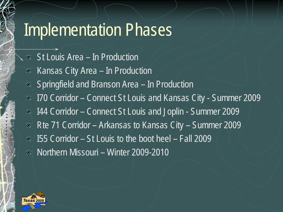
Implementation PhasesSt Louis Area – In ProductionKansas City Area – In ProductionSpringfield and Branson Area – In ProductionI70 Corridor – Connect St Louis and Kansas City - Summer 2009I44 Corridor – Connect St Louis and Joplin - Summer 2009Rte 71 Corridor – Arkansas to Kansas City – Summer 2009I55 Corridor – St Louis to the boot heel – Fall 2009Northern Missouri – Winter 2009-2010

Questions?
http://gpsweb.modot.mo.gov