Space Log istics Modeling and Simulation Analy sis using ...

Modeling CO2 Sequestration in Saline Aquifer and Depleted Oil Reservoir
to Evaluate Regional CO2 Sequestration Potential of Ozark Plateau Aquifer
System, South-Central Kansas Project Number (DE-FE0002056)
U.S. Department of Energy National Energy Technology Laboratory
Carbon Storage R&D Project Review Meeting Developing the Technologies and
Infrastructure for CCS August 20-22, 2013
W. Lynn Watney & Jason Rush (Joint PIs) Kansas Geological Survey
Lawrence, KS 66047 Brighton 1&2 2:40 August 20, 2013

2
Presentation Outline
• Benefits to the Program • Project Overview • Technical Status • Accomplishments to Date • Summary

ORGANIZATIONAL STRUCTURE
Modeling CO2 Sequestration in Saline Aquifer and Depleted Oil Reservoir to Evaluate Regional CO2
Sequestration Potential of Ozark Plateau Aquifer System, South-Central Kansas
Co-Principal Investigators Co-Principal InvestigatorsKerry D. Newell -- stratigraphy, geochemistry Evan Franseen --sedimentology, stratigraphyJason Rush -- Petrel geomodeling and data integration Robert Goldstein -- diagenesis, fluid inclusionRichard Miller -- geophysics David Fowle -- reactive pathways, microbial catalysisJohn Doveton-- log petrophysics and core-log modeling Jennifer Roberts -- reactive pathways, microbial catalysisJianghai Xia -- gravity-magnetics modeling & interpretation George Tsoflias -- geophysicsMarios Sophocleous --geohydrology
Grad Research AssistantsKey Personnel Aimee Scheffer (graduated) -- biogeology & geochemistryJohn Victorine -- Java web app development Breanna Huff -- biogeologyDavid Laflen -- manage core & curation Christa Jackson -- biogeology and geochemistryMike Killion -- modify ESRI map service for project Ayrat Sirazhiev (graduated) -- geophysicsJennifer Raney -- asst. project manager Yousuf Fadolalkarem -- geophysicsDebra Stewart, Dan Suchy -- data management Brad King -- diagenesis
Yevhen 'Eugene' Holubnyak, Petroleum EngineerFatemeh "Mina" FazelAlavi, Engineering Research Assistant
Tom Hansen, Principal, Wichita, Geological Supervision - regional data, Arbuckle hydrogeologyPaul Gerlach -- regional data acquisition, 2 yrs.
Key Personnel Larry Nicholson -- regional data acquisition, 2 yrs. Dana Wreath - manager, reservoir and production engineer Anna Smith -- regional data acquisition, 2 yrs. Randy Koudele - reservoir engineer Ken Cooper, Petrotek Engineering, Littleton, CO- engineer, well injection, hydrogeology Bill Lamb - reservoir engineer John Lorenz, Scott Cooper, FractureStudies, Edgewood, NM -- core fracture study
LOGDIGI, LLC, Katy, TX - wireline log digitizing
Co-Principal Investigators David G. KOGER, Dallas, TX - remote sensing data and analysis
Saugata Datta -- reactive pathways and reaction constants Weatherford Laboratories, Houston, TX -- core analyses
Abdelmoneam Raef -- seismic analysis and modeling CMG - Simulation Services, Calgary, Alberta --greenhouse gas simulation and softwareHalliburton, Liberal, KS -- wireline logging services
Grad Research Assistants Hedke-Saenger Geoscience, LTD., Wichita, KS - geophysical acquistion, interpret & design
Robin Barker (graduated) Susan E. Nissen, McLouth, KS -- Geophysical Consultant, volumetic curvature
Derek Ohl - seismic analysis and modeling Lockhart Geophysical, Denver, CO -- acquis & interpret 2D shear wave, gravity & mag
Randi Isham -- seismic Fairfield Industries, Inc., Denver, CO -- 2D, 3D multicomponent seismic processing
Brent Campbell - aqueous geochemistry Paragon Geophysical Services, Wichita, KS -- 3D seismic acquisition
Echo Geophysical, Denver, CO -- 3D seismic processing
Southwest Kansas CO2 EOR Initiative - Chester Morrow Converging Point - QC seismic acquisition
Martin Dubois, IHR, LLC -- team lead, geomodeling Noble Energy, Houston, TX; Denver, CO -- collaborating co., fields adjoining Wellington
John Youle, Sunflower Energy -- core and depositional modelsRay Sorenson, consultant -- data acquisition and advisingEugene Williams, Williams Engineering -- reservoir modeling
Seismic and Geochemical Services
UNIVERSITY OF KANSAS
Kansas Geological Survey KU Department of Geology
SUBCONTRACTS
Berexco, Beredco Drilling -- Wichita, KS Bittersweet Energy, Inc., Wichita, KS
Principal InvestigatorsJason Rush -- Joint PI
W. Lynn Watney - Joint PI
Wellington Field access; drilling, coring, completion and testing; modeling and simulation
Kansas State University Services
DOE project team -- DE-FE002056
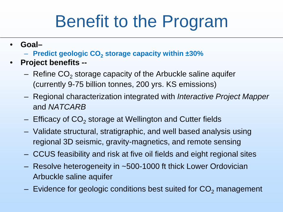
Benefit to the Program • Goal–
– Predict geologic CO2 storage capacity within ±30% • Project benefits --
– Refine CO2 storage capacity of the Arbuckle saline aquifer (currently 9-75 billion tonnes, 200 yrs. KS emissions)
– Regional characterization integrated with Interactive Project Mapper and NATCARB
– Efficacy of CO2 storage at Wellington and Cutter fields – Validate structural, stratigraphic, and well based analysis using
regional 3D seismic, gravity-magnetics, and remote sensing – CCUS feasibility and risk at five oil fields and eight regional sites – Resolve heterogeneity in ~500-1000 ft thick Lower Ordovician
Arbuckle saline aquifer – Evidence for geologic conditions best suited for CO2 management
5
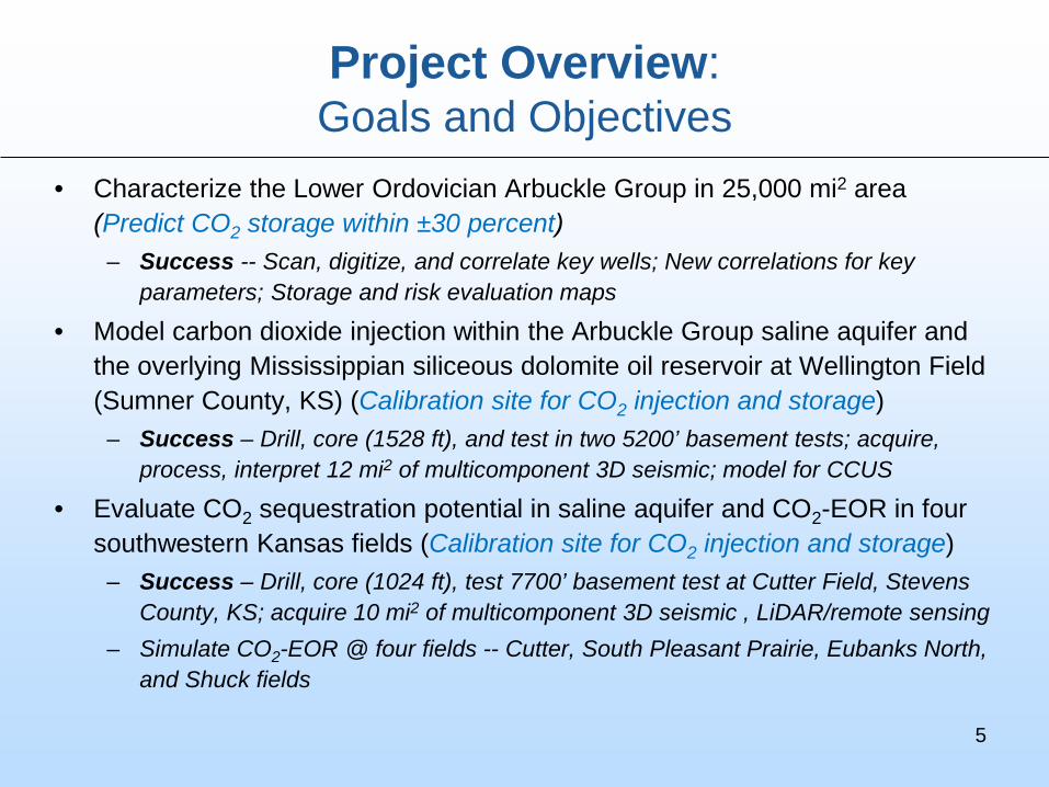
Project Overview: Goals and Objectives
• Characterize the Lower Ordovician Arbuckle Group in 25,000 mi2 area (Predict CO2 storage within ±30 percent)
– Success -- Scan, digitize, and correlate key wells; New correlations for key parameters; Storage and risk evaluation maps
• Model carbon dioxide injection within the Arbuckle Group saline aquifer and the overlying Mississippian siliceous dolomite oil reservoir at Wellington Field (Sumner County, KS) (Calibration site for CO2 injection and storage)
– Success – Drill, core (1528 ft), and test in two 5200’ basement tests; acquire, process, interpret 12 mi2 of multicomponent 3D seismic; model for CCUS
• Evaluate CO2 sequestration potential in saline aquifer and CO2-EOR in four southwestern Kansas fields (Calibration site for CO2 injection and storage)
– Success – Drill, core (1024 ft), test 7700’ basement test at Cutter Field, Stevens County, KS; acquire 10 mi2 of multicomponent 3D seismic , LiDAR/remote sensing
– Simulate CO2-EOR @ four fields -- Cutter, South Pleasant Prairie, Eubanks North, and Shuck fields

Wellington Field
Top Mississippian Structure, 10 ft C.I.
6 miles
Wellington Field Site of proposed Small Scale Field Test

Southwest Kansas CO2 Consortium(Western Annex)
?
South
North
Initial Study Area
CO2 EOR Study
Expanded Study Area
Initial Study Area
CO2 EOR Study
Expanded Study Area
Seismic blocks are color coded by operator(~120 mi2 of 3D seismic)
Chester/Morrow Sandstone (IVF) &
Deep saline Arbuckle aquifer
Technical Status Evaluate CO2 sequestration potential in Arbuckle Group saline aquifer and
CO2-EOR in four fields in southwestern Kansas
7

Dubois, 2012 8
Southwest Kansas CO2-EOR Initiative Integrated Multi-Discipline Project for CO2-EOR Evaluation
Petrophysics: Core K-Phi, corrected porosity, free water level, J-function
Geophysics: structure, attributes, faults
Geology: Formation tops, sequence stratigraphy, core lithofacies, lithofacies prediction (NNet)
Engineering: PVT and fluid analysis, recurrent histories, dynamic modeling
St. Louis
Chester
pebbly sand conglomerate
100
ft
PS1
PS2
St. Louis
Morrow?
Chester IVF
Fluid History by Month
0
10
20
30
40
50
60
70
80
1990
-1
1995
-1
2000
-1
2005
-1
2010
-1
Oil-
Gas
-Wtr
(mb,
mm
cf)
0
50
100
150
200
250
Wtr
- Pro
d &
Inj (
mb)
OilGasWaterInj. Water
Static Model
Dynamic Model
0.001
0.01
0.1
1
10
100
1000
0 5 10 15 20 25Porosity (%)
Perm
(md)
WkStrat & LamPebbly ssXbed ssCongBasal Cong Zn
Example from modeling of Pleasant Prairie South

April 16, 2013 KGS, Wichita KS 9
Water Saturation
and Permeability
Sw (0-1)
Perm xy (0.1-1000 md)
Pleasant Prairie South Field

CO2 EOR Projections – Pleasant Prairie South Field EUR 6.59
mmbo
Oil Rate
NFA - EUR 4.64 mmbo
13 years injection
Assumptions: 1. Convert WIW to CO2 IW 2. Oil wells as is 3. Inject 5 mmcfd CO2, not
exceeding bhp 2600 psi 4. Continuous CO2, no WAG 5. Injection = production 6. No optimization
NFA oil rate
Primary 15.8%Secondary 15.8%
CO2 13.3%45.0%
RF as f (OOIP)
Projections: OIL (mmbo)Cumulative 2011 4.48NFA cum. 2026 4.64CO2 case cum. 6.59Increment. CO2 1.95Cum. 2012-2026 2.11CO2 mm tonsCO2 injected (mmcf) 23.7 1.38CO2 produced (mmcf) 13.2 0.77CO2 sequestered (mmcf) 10.5 0.61Gross utilization (mcf/bo) 11.2Net utilization (mcf/bo) 5.0
Assume 56% CO2 is recycled

Victory
Modified from Dubois (DOE/KGS-CO2)

100 ft
50 miles
Morrowan
-Influence of structurally controlled fall lines during deposition?

Pleasant Prairie structural block Fault orientation - right lateral component along restraining bend
MRW
MER
ARBK
PC
A
A’’
A A’
Morrow Meramec – U. Ordo. Viola
Arbuckle
basement
2 mi
U D
Inferred Karst
Flower structure- Right lateral fault?
?
20% thinning
A A’ Morrow to Basement
Isochron Arbitrary Profile A-A’, SW – NE
?
SW NE
Hedke (DOE-CO2)

Arbuckle Time Structure (Pleasant Prairie Field)
• Meramec age karst partly defines Chester incised valley location
• Intersecting with NW-trending Arbuckle karst trend with north-trending fault corresponding with location of Chester IVF
2 mi
? U D
Hedke (DOE/KGS-CO2)
Fault bounded orthogonal structural block: -Regional NW-trending lineament -Paleo Arbuckle karst (Ordovician)

• Horst blocks : Cutter, Victory-Eubank and Pleasant Prairie
(faulted on south and west flanks) • Horst blocks : north sides of regional
NW-trending lineaments • Contour Interval: 25’ (smoothed) • White line: Chester incised valley axis • Pink Rectangles: Chester valley fill fields
(DOE investigated)
HASKELL GRANT
SEWARD
STEVENS
Chester incision and fill predated post-Mississippian – pre-Middle Pennsylvanian Ouachita structural events • However, traps in valley fill sand pools sprung by Ouachita events. • No channel deflection • Ubiquitous fractures in Chester IVF
cores. • Antecendent paleogeomorphology –
stepwise subsidence and slope to south controlled regional drainage
Eubanks 6.5 Million BO
Cutter 7.7 Million BO (Morrow)
Shuck 7.8 Million BO
Pleasant Prairie South 4.36 Million BO
Victory
6 mi (10 km) Youle (DOE/KGS-CO2)
Subsea structure on top of Mississippian Meramec
(mostly Ste. Gen.)

200 ft
oil show
Test intervals
Upper half of cored interval
Morrow
Chester
St. Louis
Warsaw
Osage
no show
11
10
8
9
12
Oil Pay Zones
Berexco Cutter KGS #1
Cutter Field Multiple pay & shows

oil show No oil on perf and swab
Gasconade
200 ft
Lower half of cored interval
Test intervals
1 2
3
4
5
6
7
Top Arbuckle
Top Simpson
Top Viola
Top Gunter Ss.
Top Proterozoic basement
Berexco Cutter KGS #1
Cutter Field
• Extended oil shows (fluorescence) in lower Paleozoic
• Upthrown structural block near regional fault
• Prior work: Chester oil in Hitch Field has Ordovician source
(Kim et al., 2010)
Tested minor oil
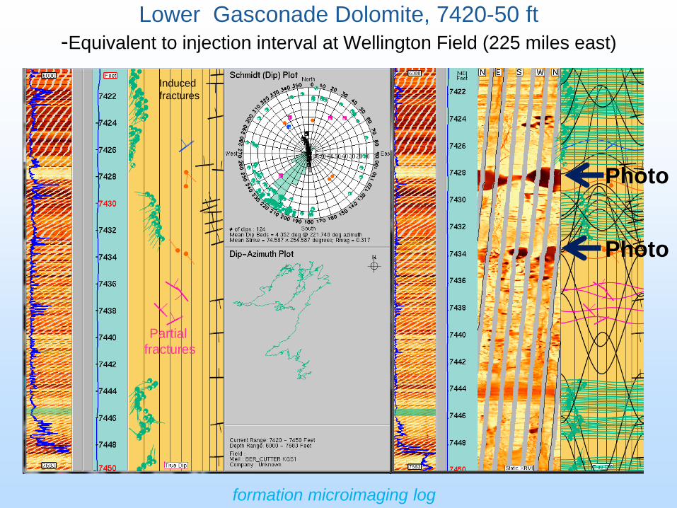
Lower Gasconade Dolomite, 7420-50 ft -Equivalent to injection interval at Wellington Field (225 miles east)
Partial fractures
Induced fractures
Photo
Photo
formation microimaging log

Lower Gasconade, 7427 ft (core depth 3 ft high to log)
Dolomitic packstone-grainstone, medium to coarse grained vugs, occ. diagonal fractures

Lower Gasconade, 7433 ft (core depth 3 ft high to log)
Gray-brown, packstone with quartz sandstone, cm sized vugs interconnected cut across core, saddle dolomite, very porous breccia

Seward County

Interactive map -Compare control well with well to be classified
Seward County -- 700+ ft of Proterozoic arkose below Arbuckle in SW portion of Seward County

arkose
400 ft Top Proterozoic
Top Proterozoic
Top Arbuckle
Top Arbuckle
SW-NE Structural Cross Section of Lower Paleozoic in Seward County
Gunter Ss.

Drilling, Coring, and Seismic Data at Cutter and Wellington Western Calibration for Regional CO2 Storage Assessment
24
Wellington Field
Sumner Co.
Cutter Field Stevens Co.
Arbuckle Structure on Magnetics

Risk Assessment – Correlation between high Plains Aquifer Isopach
and Surface Low in Southwest Kansas
25
Cutter Field
30 mi
Pleasant Prairie
Eubank S.
Shuck Field
Surface DEM – gray scale High Plains Isopach – 25 ft C.I.
Regional modeling site outline

10 Static-Dynamic Modeling Sites in Assessment Area

Coarse Grid Simulations - Arbuckle Saline Aquifer Improve Assessment of CO2 Sequestration Capacity
Geomodel input format for coarse grid simulation prior to final regional assessment Grid Cell Size: 330 ft, Col: 56, Row: 73, total cells: 4088 • Info on Grids in Zmap based on
stratigraphic divisions, lithofacies, and pore types
• Parameters assigned by fuzzy logic correlations from core and log data from Cutter and Wellington fields -- • Phi • K and relative permeability • Capillary pressure for supercritical CO2

Improved permeability estimation in Wellington #1-32:
-micro, meso, and mega groups defined
-core FZI and irreducible water saturation (from MRI log)
-permeability computed from FZI value
Black points = core measured permeability

Fuzzy Partitioning Systems for Electrofacies Classification
29
Finol et al. (2001)
Bosch et al., in press Cuddy and Glover (2002)
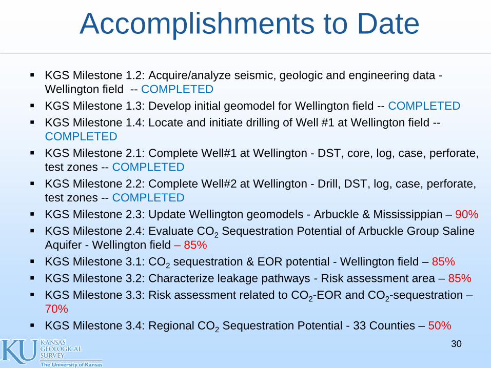
Accomplishments to Date KGS Milestone 1.2: Acquire/analyze seismic, geologic and engineering data -
Wellington field -- COMPLETED KGS Milestone 1.3: Develop initial geomodel for Wellington field -- COMPLETED KGS Milestone 1.4: Locate and initiate drilling of Well #1 at Wellington field --
COMPLETED KGS Milestone 2.1: Complete Well#1 at Wellington - DST, core, log, case, perforate,
test zones -- COMPLETED KGS Milestone 2.2: Complete Well#2 at Wellington - Drill, DST, log, case, perforate,
test zones -- COMPLETED KGS Milestone 2.3: Update Wellington geomodels - Arbuckle & Mississippian – 90% KGS Milestone 2.4: Evaluate CO2 Sequestration Potential of Arbuckle Group Saline
Aquifer - Wellington field – 85% KGS Milestone 3.1: CO2 sequestration & EOR potential - Wellington field – 85% KGS Milestone 3.2: Characterize leakage pathways - Risk assessment area – 85% KGS Milestone 3.3: Risk assessment related to CO2-EOR and CO2-sequestration –
70% KGS Milestone 3.4: Regional CO2 Sequestration Potential - 33 Counties – 50%
30
Summary • Key findings
1. Initial estimates of CO2 P10 & P90 Arbuckle aquifer storage are 8.8 and 75.5 billion metric tons. 2. Core, logs, seismic, DST, geochemical and microbial analysis, and step- rate test at Wellington Field indicate that lower Arbuckle is a primary injection interval (~150 ft thick) overlain by widespread thick (400 ft) baffle/barrier in mid Arbuckle. 3. Geochemical and microbial analyses indicate that upper and lower portions of the Arbuckle saline aquifer are not in hydraulic communication. 4. Thick (~120 ft) primary caprock in lower Mississippian (“Pierson Fm.”) augments the Chattanooga Shale and Simpson Group in south-central Kansas.
• Future Plans – Complete geomodels and simulations in SW Kansas fields and Wellington – Refine regional CO2 storage estimates from quantitative analysis of LAS log files
and static and dynamic modeling at 10 sites – Complete project by Febuary 2014 31

Appendix
32

ORGANIZATIONAL STRUCTURE
Modeling CO2 Sequestration in Saline Aquifer and Depleted Oil Reservoir to Evaluate Regional CO2
Sequestration Potential of Ozark Plateau Aquifer System, South-Central Kansas
Co-Principal Investigators Co-Principal InvestigatorsKerry D. Newell -- stratigraphy, geochemistry Evan Franseen --sedimentology, stratigraphyJason Rush -- Petrel geomodeling and data integration Robert Goldstein -- diagenesis, fluid inclusionRichard Miller -- geophysics David Fowle -- reactive pathways, microbial catalysisJohn Doveton-- log petrophysics and core-log modeling Jennifer Roberts -- reactive pathways, microbial catalysisJianghai Xia -- gravity-magnetics modeling & interpretation George Tsoflias -- geophysicsMarios Sophocleous --geohydrology
Grad Research AssistantsKey Personnel Aimee Scheffer (graduated) -- biogeology & geochemistryJohn Victorine -- Java web app development Breanna Huff -- biogeologyDavid Laflen -- manage core & curation Christa Jackson -- biogeology and geochemistryMike Killion -- modify ESRI map service for project Ayrat Sirazhiev (graduated) -- geophysicsJennifer Raney -- asst. project manager Yousuf Fadolalkarem -- geophysicsDebra Stewart, Dan Suchy -- data management Brad King -- diagenesis
Yevhen 'Eugene' Holubnyak, Petroleum EngineerFatemeh "Mina" FazelAlavi, Engineering Research Assistant
Tom Hansen, Principal, Wichita, Geological Supervision - regional data, Arbuckle hydrogeologyPaul Gerlach -- regional data acquisition, 2 yrs.
Key Personnel Larry Nicholson -- regional data acquisition, 2 yrs. Dana Wreath - manager, reservoir and production engineer Anna Smith -- regional data acquisition, 2 yrs. Randy Koudele - reservoir engineer Ken Cooper, Petrotek Engineering, Littleton, CO- engineer, well injection, hydrogeology Bill Lamb - reservoir engineer John Lorenz, Scott Cooper, FractureStudies, Edgewood, NM -- core fracture study
LOGDIGI, LLC, Katy, TX - wireline log digitizing
Co-Principal Investigators David G. KOGER, Dallas, TX - remote sensing data and analysis
Saugata Datta -- reactive pathways and reaction constants Weatherford Laboratories, Houston, TX -- core analyses
Abdelmoneam Raef -- seismic analysis and modeling CMG - Simulation Services, Calgary, Alberta --greenhouse gas simulation and softwareHalliburton, Liberal, KS -- wireline logging services
Grad Research Assistants Hedke-Saenger Geoscience, LTD., Wichita, KS - geophysical acquistion, interpret & design
Robin Barker (graduated) Susan E. Nissen, McLouth, KS -- Geophysical Consultant, volumetic curvature
Derek Ohl - seismic analysis and modeling Lockhart Geophysical, Denver, CO -- acquis & interpret 2D shear wave, gravity & mag
Randi Isham -- seismic Fairfield Industries, Inc., Denver, CO -- 2D, 3D multicomponent seismic processing
Brent Campbell - aqueous geochemistry Paragon Geophysical Services, Wichita, KS -- 3D seismic acquisition
Echo Geophysical, Denver, CO -- 3D seismic processing
Southwest Kansas CO2 EOR Initiative - Chester Morrow Converging Point - QC seismic acquisition
Martin Dubois, IHR, LLC -- team lead, geomodeling Noble Energy, Houston, TX; Denver, CO -- collaborating co., fields adjoining Wellington
John Youle, Sunflower Energy -- core and depositional modelsRay Sorenson, consultant -- data acquisition and advisingEugene Williams, Williams Engineering -- reservoir modeling
Seismic and Geochemical Services
UNIVERSITY OF KANSAS
Kansas Geological Survey KU Department of Geology
SUBCONTRACTS
Berexco, Beredco Drilling -- Wichita, KS Bittersweet Energy, Inc., Wichita, KS
Principal InvestigatorsJason Rush -- Joint PI
W. Lynn Watney - Joint PI
Wellington Field access; drilling, coring, completion and testing; modeling and simulation
Kansas State University Services
DOE project -- DE-FE002056
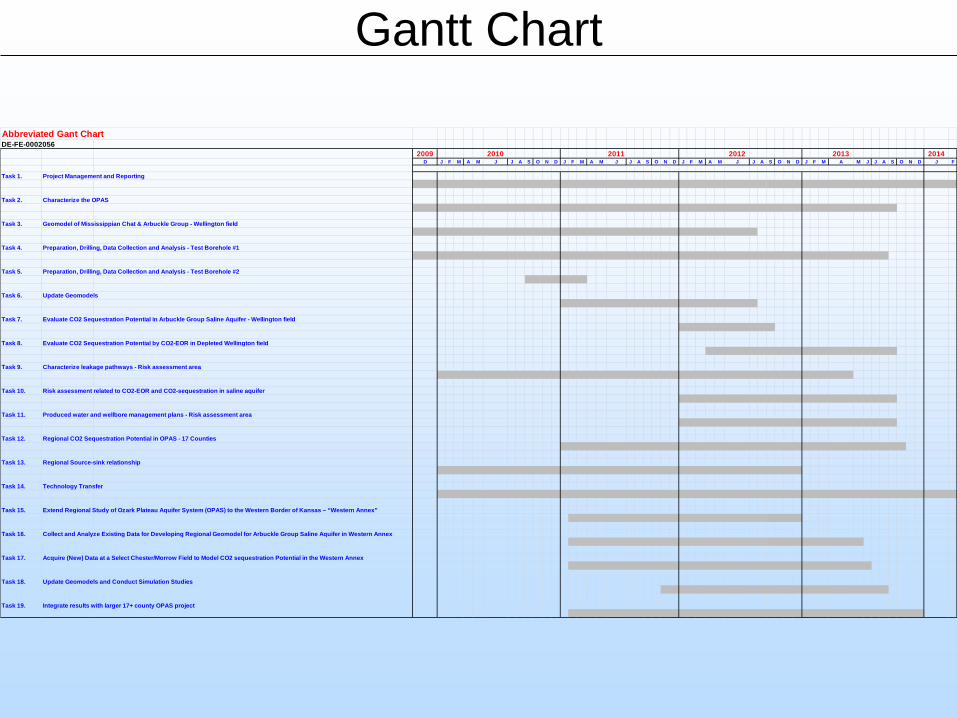
Gantt Chart
Abbreviated Gant Chart DE-FE-0002056
2009 2010 2011 2012 2013 2014D J F M A M J J A S O N D J F M A M J J A S O N D J F M A M J J A S O N D J F M A M J J A S O N D J F
Task 1. Project Management and Reporting
Task 2. Characterize the OPAS
Task 3. Geomodel of Mississippian Chat & Arbuckle Group - Wellington field
Task 4. Preparation, Drilling, Data Collection and Analysis - Test Borehole #1
Task 5. Preparation, Drilling, Data Collection and Analysis - Test Borehole #2
Task 6. Update Geomodels
Task 7. Evaluate CO2 Sequestration Potential in Arbuckle Group Saline Aquifer - Wellington field
Task 8. Evaluate CO2 Sequestration Potential by CO2-EOR in Depleted Wellington field
Task 9. Characterize leakage pathways - Risk assessment area
Task 10. Risk assessment related to CO2-EOR and CO2-sequestration in saline aquifer
Task 11. Produced water and wellbore management plans - Risk assessment area
Task 12. Regional CO2 Sequestration Potential in OPAS - 17 Counties
Task 13. Regional Source-sink relationship
Task 14. Technology Transfer
Task 15. Extend Regional Study of Ozark Plateau Aquifer System (OPAS) to the Western Border of Kansas – “Western Annex”
Task 16. Collect and Analyze Existing Data for Developing Regional Geomodel for Arbuckle Group Saline Aquifer in Western Annex
Task 17. Acquire (New) Data at a Select Chester/Morrow Field to Model CO2 sequestration Potential in the Western Annex
Task 18. Update Geomodels and Conduct Simulation Studies
Task 19. Integrate results with larger 17+ county OPAS project

Bibliography
35
Watney, W.L., Newell, K.D., Holubnyak, E., and Raney, J., 2013, “Oil and Gas in Central Kansas Potential for Enhanced Oil Recovery Using CO2”, regarding use of petroleum coke in refinery that would include CO2 generation: to McPherson Kansas Development Corporation hosted meeting, April 3. Watney, W.L., 2013, Analysis of the Late Devonian to Early Carboniferous (Fransnian-Tornaisian) Woodford (Chattanooga) Shale, presentation to AAPG Forum Woodford, Oklahoma City, April 11. This is an important caprock in Kansas and Oklahoma. Watney, W.L., 2013, Petrophysical Analyses and Integrated Approaches, April 16-19, AAPG Short Course, Austin, TX. Centerpiece of the course material comes from the DOE-CO2 project Watney, W.L., 2013, Mississippian Exploration: Stratigraphy, Petrology, and Reservoir Properties with an emphasis on Wellington Field, April 23, Denver, RMAG & PTTC Symposium titled, “Making Money with Science”, April 23, Denver, Colorado. W. Lynn Watney, John Youle, Dennis Hedke, Paul Gerlach, Raymond Sorenson, Martin Dubois, Larry Nicholson, Thomas Hansen, David Koger, and Ralph Baker, 2013, Sedimentologic and Stratigraphic Effects of Episodic Structural Activity During the Phanerozoic in the Hugoton Embayment, Kansas USA: AAPG Annual Meeting, Oral presentation, Pittsburgh, PA, May 21 W. Lynn Watney, Jason Rush, Martin Dubois, Robinson Barker, Tiraz Birdie, Ken Cooper, Saugata Datta, John Doveton, Mina Fazelalavi, David Fowle, Paul Gerlach, Thomas Hansen, Dennis Hedke, Yevhen Holubnyak, Breanna Huff, K. David Newell, Larry Nicholson, Jennifer Roberts, Aimee Scheffer, Ayrat Sirazhiev, Raymond Sorenson, Georgios Tsoflias, Eugene Williams, Dana Wreath, John Youle, 2013, Evaluating Carbon Storage in Morrowan and Mississippian oil fields and Underlying Lower Ordovician Arbuckle Saline Aquifer in Southern Kansas: AAPG Annual Meeting, Poster, Pittsburgh, PA, May 20. DOE Site visit and project review, June 3-5, 2013, Regional CO2 Storage, Wellington and Cutter field calibration sites, SW Kansas CO2-EOR Initiative, and Small Scale CO2 Test Injection at Wellington, Wichita, KS. Watney, L., Rush, J., Raney J., and Brian Dressel, DOE Project Manager, 2013, Presentation to the 2013 KGS Annual Kansas Field Conference. Participants included Kansas legislators and state officials, morning of Tuesday, June 4th, Meet bus at site of Wellington KGS #1-32. Brought core and posters in addition to describing DOE-CO2 project and answering questions pertaining economics, safety, and policy. The 2013 KGS Annual Field Conference was carried out by Shane A. Lyle, Catherine S. Evans, Rex C. Buchanan, and Robert S. Sawin and was focused on “South-Central Kansas Oil Exploration, Water Allocation, and Range Management”. This project is operated by the Kansas Geological Survey and funded, in part, by the Kansas Water Office, the Kansas Department of Transportation, and the Kansas Department of Wildlife, Parks and Tourism. The Wellington Field was Stop #1 on the trip that traversed south-central Kansas (Figure 37). Members of the DOE-CO2 team met the bus at the site of Berexco Wellington KGS #1-32 in Wellington Field.

36
GEOCHEMICAL AND MINERALOGICAL CHARACTERIZATION OF THE ARBUCKLE AQUIFER: STUDYING MINERAL REACTIONS AND ITS IMPLICATIONS FOR CO2 SEQUESTRATION BARKER, Robinson1, WATNEY, W. Lynn2, SCHEFFER, Aimee3, FORD, Sophia1, and DATTA, Saugata1, (1) Department of Geology, Kansas State University, 108 Thompson Hall, Manhattan, KS 66506, [email protected], (2) Kansas Geological Survey, Univ of Kansas, 1930 Constant Avenue, Lawrence, KS 66047, (3) Geology, University of Kansas, 1475 Jayhawk Blv. Room 120, Lawrence, KS 66045 GEOCHEMICAL AND MICROBIOLOGICAL INFLUENCES ON SEAL INTEGRITY DURING SC-CO2 EXPOSURE, ARBUCKLE AQUIFER, SE KANSAS JACKSON, Christa1, SCHEFFER, Aimee2, FOWLE, David3, WATNEY, W. Lynn4, STRAZISAR, Brian5, and ROBERTS, Jennifer A.3, (1) Geology, University of Kansas, 1475 Jayhawk Blvd, Room 120, Lawrence, KS 66045, [email protected], (2) Geology, University of Kansas, 1475 Jayhawk Blv. Room 120, Lawrence, KS 66045, (3) Geology, University of Kansas, Multidisciplinary Research Building, 2030 Becker Dr, Lawrence, KS 66047, (4) Kansas Geological Survey, Univ of Kansas, 1930 Constant Avenue, Lawrence, KS 66047, (5) Geomechanics and Flow Laboratory, National Energy Technology Laboratory, 626 Cochrans Mill Road, PO Box 10940, Pittsburgh, PA 15236 GEOCHEMICAL, MICROBIOLOGICAL, AND PERMEABILITY CHARACTERISTICS INDICATING VERTICAL ZONATION OF THE ARBUCKLE SALINE AQUIFER, A POTENTIAL CO2 STORAGE RESERVOIR SCHEFFER, Aimee1, STOTLER, Randy L.2, WATNEY, W. Lynn3, FOWLE, David4, DOVETON, John H.5, RUSH, Jason6, NEWELL, K. David7, FAZELALAVI, Mina3, WHITTEMORE, Donald O.8, and ROBERTS, Jennifer A.4, (1) Geology, University of Kansas, 1475 Jayhawk Blv. Room 120, Lawrence, KS 66045, [email protected], (2) Department of Geology, University of Kansas, Lawrence, KS 66045, (3) Kansas Geological Survey, Univ of Kansas, 1930 Constant Avenue, Lawrence, KS 66047, (4) Geology, University of Kansas, Multidisciplinary Research Building, 2030 Becker Dr, Lawrence, KS 66047, (5) Kansas Geological Survey, Univ of Kansas, 1930 Constant Avenue, Campus West, Lawrence, KS 66047, (6) Kansas Geological Survey, The University of Kansas, 1930 Constant Avenue, Lawrence, KS 66047, (7) Kansas Geological Survey, University of Kansas, 1930 Constant Avenue, Lawrence, KS 66047-3726, (8) Kansas Geological Survey, University of Kansas, 1930 Constant Ave, Lawrence, KS 66047

37
M.S. Theses Ayrat Sirazhiev, 2012, Seismic Attribute Analysis of the Mississippian Chert at the Wellington Field, south-central Kansas: M.S. Thesis, Department of Geology, The University of Kansas. Ohl, Derek Robert, 2012, Rock formation characterization for carbon dioxide geosequestration: 3D seismic amplitude and coherency anomalies, and seismic petrophysical facies classification, Wellington and Anson-Bates fields, Sumner County, Kansas, USA, M.S. Thesis, Department of Geology, Kansas State University, 77 p. Randi Jo Lee, 2012, Integration of in situ and laboratory velocity measurements: analysis and calibration for rock formation characterization Isham, M.S. Thesis, Department of Geology, Kansas State University. Presentations Geofest 2012, October 26th 2012, held in Lawrence, KS at Kansas Geological Survey, focused on a review of the DOE funded CCUS research in a morning seminar and a core workshop in the afternoon to examine the entire 1600 ft long core from Wellington KGS #1-32. Attendees included members of the Kansas Geological Society, Kansas Geological Survey, Departments of Geology at Kansas University and Wichita State University


![faculty.weber.edufaculty.weber.edu/aghoreishi/Math3550_F15/Math 3550...4 | Basic Mathematica Commands for Math Modeling. nb 125.3 72 1.74028 0.745356 N [EA2] 7.38906 Log [ % ] Log](https://static.fdocuments.us/doc/165x107/5b1b9a337f8b9a41258ecf5f/35504-basic-mathematica-commands-for-math-modeling-nb-1253-72-174028-0745356.jpg)