MISSISSIPPI RIVER BASIN - Home | NRCS River Basin Healthy Watersheds Initiative (MRBI) in 2009 to...
6
2010 Conservation Activities The Natural Resources Conservation Service (NRCS) kicked off the Mississippi River Basin Healthy Watersheds Initiative (MRBI) in 2009 to improve water quality and wildlife habitat in the Mississippi River Basin. The 12-state initiative builds on the cooperative work of NRCS and its conservation partners in the basin, and offers agricultural producers in priority watersheds the opportunity for voluntary technical and financial assistance. NRCS has identified MRBI as a priority due to water quality concerns, primarily the effect of nutrient loading on the health of local water bodies and in the Gulf of Mexico. NRCS and its partners are using a conservation systems approach to help producers optimize nitrogen and phosphorus use in agricultural fields and minimize nutrients in runoff. NRCS is providing producers a suite of practices to control soil erosion, and improve soil and water quality through the Cooperative Conservation Partnership Initiative (CCPI) using existing Farm Bill conservation programs. Key conservation practices include nutrient management, conservation crop rotation, and residue and tillage management. Producers also can restore wetlands and plant trees along streams. On a voluntary basis, participants can receive financial assistance to install edge-of- field monitoring water quality systems in selected small watersheds. This monitoring will help NRCS assess environmental outcomes of this work. The 12 states participating are Arkansas, Illinois, Indiana, Iowa, Kentucky, Louisiana, Minnesota, Mississippi, Missouri, Ohio, Tennessee and Wisconsin. South Dakota will be added to the Initiative in 2011, bringing the number of states to 13. Conservation partners include Indian tribes, state and local units of government, farmer cooperatives, producer associations, universities and other nongovernmental organizations. RIVER BASIN MISSISSIPPI INITIATIVE Did You Know? • The Mississippi River has the third largest drainage basin in the world, exceeded in size only by the watersheds of the Amazon and Congo Rivers. • It drains 41 percent of the 48 contiguous states of the United States; covers more than 1,245,000 square miles; includes all or parts of 31 states and two Canadian provinces; and roughly resembles a funnel which has its spout at the Gulf of Mexico. • Waters from as far east as New York and as far west as Montana contribute to flows in the lower river. • More than 50 cities and 18 million people rely on the Mississippi River for their daily water supply. • The Mississippi River is the main stem of a network of inland navigable waterways which form a system of about 12,350 miles in length, not including the Gulf Intracoastal Waterway of 1,173 miles. MRBI COVERAGE AREA MAP HEALTHY WATERSHEDS
Transcript of MISSISSIPPI RIVER BASIN - Home | NRCS River Basin Healthy Watersheds Initiative (MRBI) in 2009 to...
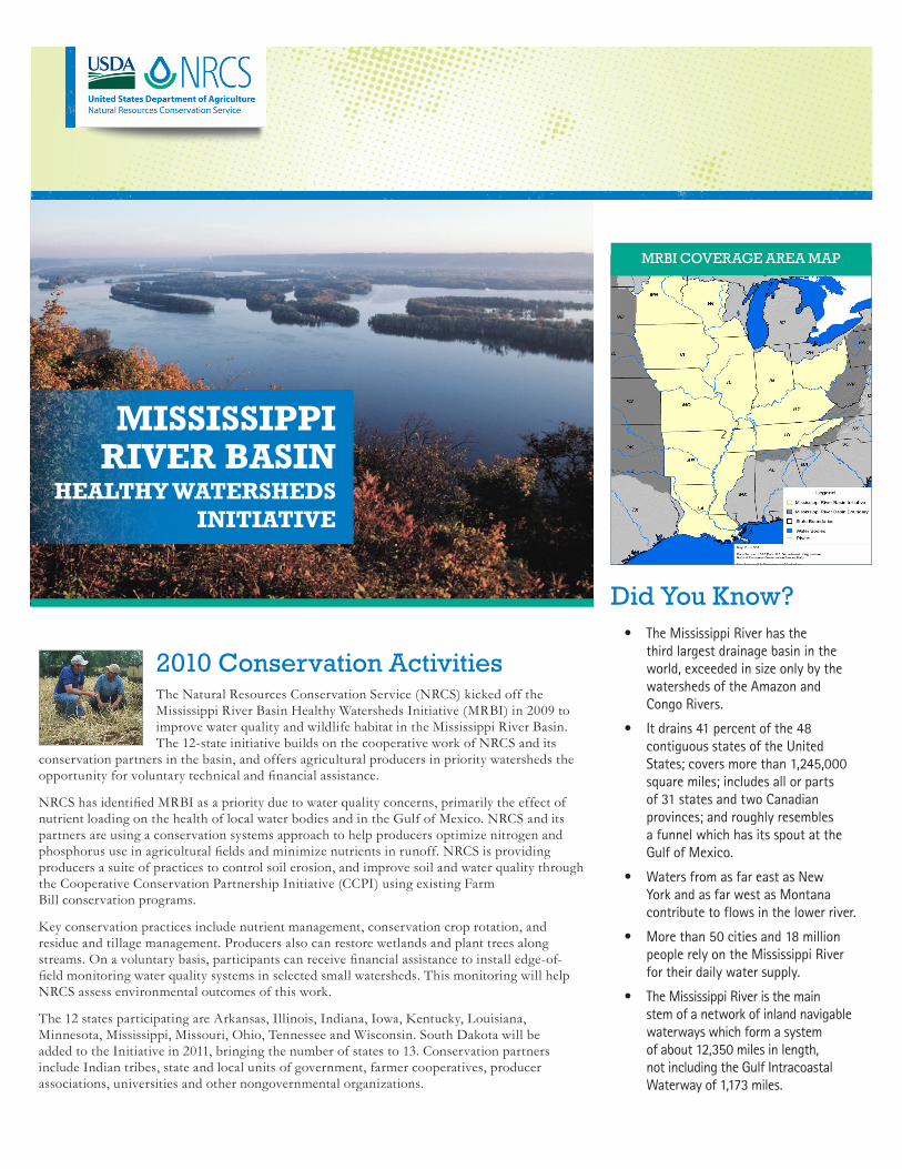
2010 Conservation ActivitiesThe Natural Resources Conservation Service (NRCS) kicked off the Mississippi River Basin Healthy Watersheds Initiative (MRBI) in 2009 to improve water quality and wildlife habitat in the Mississippi River Basin. The 12-state initiative builds on the cooperative work of NRCS and its
conservation partners in the basin, and offers agricultural producers in priority watersheds the opportunity for voluntary technical and financial assistance.
NRCS has identified MRBI as a priority due to water quality concerns, primarily the effect of nutrient loading on the health of local water bodies and in the Gulf of Mexico. NRCS and its partners are using a conservation systems approach to help producers optimize nitrogen and phosphorus use in agricultural fields and minimize nutrients in runoff. NRCS is providing producers a suite of practices to control soil erosion, and improve soil and water quality through the Cooperative Conservation Partnership Initiative (CCPI) using existing Farm Bill conservation programs.
Key conservation practices include nutrient management, conservation crop rotation, and residue and tillage management. Producers also can restore wetlands and plant trees along streams. On a voluntary basis, participants can receive financial assistance to install edge-of-field monitoring water quality systems in selected small watersheds. This monitoring will help NRCS assess environmental outcomes of this work.
The 12 states participating are Arkansas, Illinois, Indiana, Iowa, Kentucky, Louisiana, Minnesota, Mississippi, Missouri, Ohio, Tennessee and Wisconsin. South Dakota will be added to the Initiative in 2011, bringing the number of states to 13. Conservation partners include Indian tribes, state and local units of government, farmer cooperatives, producer associations, universities and other nongovernmental organizations.
RIVER BASINMISSISSIPPI
INITIATIVE
Did You Know?• TheMississippiRiverhasthe
thirdlargestdrainagebasinintheworld,exceededinsizeonlybythewatershedsoftheAmazonandCongoRivers.
• Itdrains41percentofthe48contiguousstatesoftheUnitedStates;coversmorethan1,245,000squaremiles;includesallorpartsof31statesandtwoCanadianprovinces;androughlyresemblesafunnelwhichhasitsspoutattheGulfofMexico.
• WatersfromasfareastasNewYorkandasfarwestasMontanacontributetoflowsinthelowerriver.
• Morethan50citiesand18millionpeoplerelyontheMississippiRiverfortheirdailywatersupply.
• TheMississippiRiveristhemainstemofanetworkofinlandnavigablewaterwayswhichformasystemofabout12,350milesinlength,notincludingtheGulfIntracoastalWaterwayof1,173miles.
MRBI COVERAGE AREA MAP
HEALTHY WATERSHEDS

2| HELPING PEOPLE HELP THE LAND – MRBI
Arkansas
Historically, fluctuating water levels and flooding have caused erosion problems on the Willow Bend Farm in Conway County. “My dad used the Soil Conservation Service when I was a kid to help deal with erosion problems,” says Ruth Spiller, manager of the farm. “I also need technical and financial help with the erosion issues. I read a lot, but I needed the expertise of the NRCS to figure out what works best on this farm,” she says.
To address her specific natural resource concerns, Spiller recently enrolled more than 1,400 acres of the farm into the MRBI project – through EQIP. Her conservation plan calls for monitoring and evaluation of nutrient runoff, waste transfer and utilization, planting cover crops, nutrient management with grid sampling, a structure for water control, wetland enhancement, conservation crop rotation and fencing off a wetland area.
Through the project, NRCS and its partners will help agricultural producers in 15 sub-watersheds of the Lake Conway-Point Remove Basin address a range of water quality issues by implementing nutrient runoff and water management conservation systems – all of which will help improve water quality in the Mississippi River Basin.
PRODUCER PROTECTS RESOURCES THROUGH PROGRAM ASSISTANCE
Conway County District Conservationist Ronnach Day (left), discusses the monitoring project planned on a Willow Bend Farm wetland with Ruth Spiller, farm manager.
Manchester College students monitor the biology in the
Middle Eel Watershed.
IndianaSTUDENTS MONITOR WATER QUALITY, BIOLOGY ON THE MIDDLE EEL
Professor Jerry Sweeten from Manchester College has been interested in water quality in the Middle Eel Watershed for a long time. Jerry and his students are using automatic water samplers and biological monitoring to better understand nutrient loading and biological systems in all the major tributaries in the watershed.
Through the MRBI partnership collaboration, NRCS is helping to fund conservation practices such as no-till, cover crops, and high-level nutrient and pest management. Partners include Soil and Water Conservation Districts, the Indiana Department of Environmental Management, and the Indiana Department of Natural Resources.
Conservation systems in the Indian Creek Watershed will benefit water quality and farm profitability.
IllinoisCONSERVATION SYSTEMS FOCUS OF INDIAN CREEK WATERSHED
The Indian Creek Watershed project is designed to illustrate the efficacy, value and impact of agricultural conservation systems on watershed environmental health. Through this high-profile watershed project, local farmers will help demonstrate and test innovative conservation practices, including conservation tillage, nutrient management, water management and beneficial cover crop use.
The Indian Creek Watershed, covering 52,480 acres, flows to the South Fork of the Vermilion River, one of NRCS’ MRBI focus areas. Agriculture dominates the watershed; 95 percent of the land is tillable and the average farm is 500 acres. Implementing conservation solutions over the planned six-year project will benefit watershed water quality and farm profitability.
NRCS, the Livingston County Soil and Water Conservation District (SWCD), and the Conservation Technology Information Center (CTIC) are leading the project, in conjunction with Illinois Environmental Protection Agency (EPA), Agri Drain Corporation, Agrium, John Deere, and other partners.
MISSISSIPPI RIVER BASIN HEALTHY WATERSHEDS INITIATIVE – MRBI | 3
Precision agriculture technology increases efficiencies for rice production while conserving natural resources.
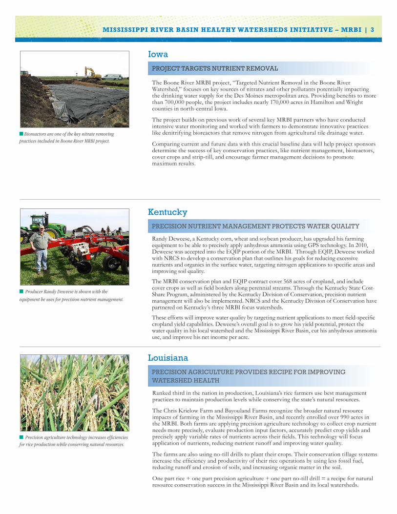
Louisiana
Ranked third in the nation in production, Louisiana’s rice farmers use best management practices to maintain production levels while conserving the state’s natural resources.
The Chris Krielow Farm and Bayouland Farms recognize the broader natural resource impacts of farming in the Mississippi River Basin, and recently enrolled over 990 acres in the MRBI. Both farms are applying precision agriculture technology to collect crop nutrient needs more precisely, evaluate production input factors, accurately predict crop yields and precisely apply variable rates of nutrients across their fields. This technology will focus application of nutrients, reducing nutrient runoff and improving water quality.
The farms are also using no-till drills to plant their crops. Their conservation tillage systems increase the efficiency and productivity of their rice operations by using less fossil fuel, reducing runoff and erosion of soils, and increasing organic matter in the soil.
One part rice + one part precision agriculture + one part no-till drill = a recipe for natural resource conservation success in the Mississippi River Basin and its local watersheds.
PRECISION AGRICULTURE PROVIDES RECIPE FOR IMPROVING WATERSHED HEALTH
KentuckyPRECISION NUTRIENT MANAGEMENT PROTECTS WATER QUALITY
Randy Deweese, a Kentucky corn, wheat and soybean producer, has upgraded his farming equipment to be able to precisely apply anhydrous ammonia using GPS technology. In 2010, Deweese was accepted into the EQIP portion of the MRBI. Through EQIP, Deweese worked with NRCS to develop a conservation plan that outlines his goals for reducing excessive nutrients and organics in the surface water, targeting nitrogen applications to specific areas and improving soil quality.
The MRBI conservation plan and EQIP contract cover 568 acres of cropland, and include cover crops as well as field borders along perennial streams. Through the Kentucky State Cost-Share Program, administered by the Kentucky Division of Conservation, precision nutrient management will also be implemented. NRCS and the Kentucky Division of Conservation have partnered on Kentucky’s three MRBI focus watersheds.
These efforts will improve water quality by targeting nutrient applications to meet field-specific cropland yield capabilities. Deweese’s overall goal is to grow his yield potential, protect the water quality in his local watershed and the Mississippi River Basin, cut his anhydrous ammonia use, and improve his net income per acre.
Producer Randy Deweese is shown with the
equipment he uses for precision nutrient management.
Bioreactors are one of the key nitrate removing practices included in Boone River MRBI project.
IowaPROJECT TARGETS NUTRIENT REMOVAL
The Boone River MRBI project, “Targeted Nutrient Removal in the Boone River Watershed,” focuses on key sources of nitrates and other pollutants potentially impacting the drinking water supply for the Des Moines metropolitan area. Providing benefits to more than 700,000 people, the project includes nearly 170,000 acres in Hamilton and Wright counties in north-central Iowa.
The project builds on previous work of several key MRBI partners who have conducted intensive water monitoring and worked with farmers to demonstrate innovative practices like denitrifying bioreactors that remove nitrogen from agricultural tile drainage water.
Comparing current and future data with this crucial baseline data will help project sponsors determine the success of key conservation practices, like nutrient management, bioreactors, cover crops and strip-till, and encourage farmer management decisions to promote maximum results.

4| HELPING PEOPLE HELP THE LAND – MRBI
MississippiREDUCING RUNOFF IMPROVES FARM EFFICIENCY
NRCS employees Cody Towery, Joey Adams, Paul Rodrigue and Trinity Long examine project progress on the Shivers Farm, managed by Boyer Britt (center). This farm near Indianola is doing its part to prevent nutrients from running off the farm.
Producers upstream from the Gulf of Mexico in the Mississippi Delta have found ways to reduce the runoff of nutrients through MRBI assistance.
Shivers Farms, 300 acres along Porter Bayou near Indianola, Mississippi, is developing a self-contained water system designed to keep both water and nutrients on the farm and out of local streams and the Gulf. The system includes a tailwater recovery reservoir, designed to capture and reuse approximately 200 acre-feet of runoff during the irrigation season, which is 45 percent of the expected annual runoff. To maximize water savings, underground pipes deliver water with minimum loss, while water monitors measure the amount of water delivered throughout the growing season.
This system not only improves water quality in the local watershed and the Gulf of Mexico, but it also minimizes use of aquifer water, which has been declining at an alarming rate because of increasing agricultural water usage throughout the Delta.
MissouriMONITORING SYSTEMS EVALUATE EDGE-OF-FIELD RUNOFF
Monitoring edge-of-field runoff in Missouri supports technical and financial assistance to landowners.
Missouri’s edge-of-field monitoring system, now utilized by several states participating in the MRBI, is in place and capturing data on about 200 acres of resource-rich land in Missouri.
“We needed a way to monitor and evaluate the edge-of-field runoff”, says Glenn Davis, state agronomist.
With the goal of monitoring edge-of-field runoff, Missouri’s NRCS staff worked to create a protocol that would support financial assistance to landowners.
“We have three steps in our protocol: flow monitoring, water quality sampling and weather information,” says Troy Chockley, state environmental engineer. “The protocol identifies different methods of flow monitoring depending on the type of outlet point.”
State Conservationist J.R. Flores says there was a critical need to create and implement an effective MRBI evaluation protocol. “We didn’t want to just implement MRBI; we also wanted a way to evaluate its effectiveness,” Flores says.
Stearns County SWCD Nutrient Management Specialists in Minnesota take a corn stalk sample for a farmer participating in MRBI.
Minnesota
The On-Farm Network, Stearns County Soil and Water Conservation District and NRCS are collaborating with farmers in Stearns County, Minnesota, to better manage nitrogen applied to farm fields, reduce nitrogen runoff, increase profits for farmers and improve water quality in the Sauk River Watershed.
The On-Farm Network’s corn stalk nitrate evaluation and replicated strip trial program uses a variety of tools, including remote sensing, GPS and yield monitors to collect data in actual field conditions. Farmers and agronomists follow established protocols that ensure the accuracy and reliability of the data collected, yet are easy and practical to implement. Trials compare a farmer’s normal nitrogen management practice with one alternative, which can be a difference in product used, application method, timing, or other management practices.
These efforts include increased implementation of nutrient management, residue and tillage management (no till and strip till), monitoring and evaluation, and waste storage facilities, resulting in reduced nitrogen use on farm fields and improved water quality.
This project and other ongoing efforts by NRCS and its partners demonstrate farmers’ concern for the environment locally and beyond.
PARTNERS WORK TO DELIVER INNOVATION IN THE SAUK WATERSHED

Edge-of-field monitoring stations, like this one in Ohio, will be used to evaluate water quality in the project area.
OhioON-FARM NETWORK OFFERED IN UPPER BIG WALNUT WATERSHED
The Delaware Soil and Water Conservation District will receive about $1.3 million in EQIP funding over four years to improve the water quality of the Upper Big Walnut Creek, which drains into the Hoover Reservoir, the largest drinking water source for the City of Columbus.
A conservation systems approach will be used to manage and optimize nitrogen and phosphorous within fields to minimize runoff and reduce downstream nutrient loading.
In addition, for the first time, the On-Farm Network® (OFN) will be offered to up to 20 farmers in the Upper Big Walnut. Pioneered in Iowa, the OFN is an adaptive management approach that allows farmers to fine-tune nutrient applications for improved efficiency, management and economics. The Upper Big Walnut OFN will follow protocols already established in Northwest Ohio under the Maumee OFN. The program will help cooperators install strip trials for different nitrogen rates, monitor them through aerial imagery, collect data on nutrient inputs, and conduct guided corn stalk tests in the fall. Cooperators will attend winter meetings where the anonymous data will be analyzed and discussed.
EQIP assistance was provided to install filter strips and a rock grade stabilization structure, which controls erosion and protects the nearby stream.
Tennessee
GRADE STABILIZATION STRUCTURE AND BUFFER STRIPS PROVIDE EROSION CONTROL
Jon McKinnis knew he had an erosion problem, so he contacted his local NRCS office for assistance. Using funds from the MRBI portion of EQIP, he was able to install a grade stabilization structure to stop the stream bank erosion problem. The surrounding area was then seeded in grass to prevent future erosion.
Additional EQIP funds were used to install a 3.2 acre, 30-foot wide filter strip, along the entire field edge bordering the stream. The filter strip helps to keep nutrients out of the stream. This kept the nutrients on the land where they were needed, reduced fertilizer needs, and saved money. “The filter strip and grade stabilization rock structure are working perfectly,” says McKinnis. “We are impressed with how they have held up this winter. Every year we have had erosion problems with water from the crop field entering the creek, but this year the grass buffer has helped tremendously. I will enroll more of my land into buffer programs. I would recommend others working with the agency to address similar problems.”
MISSISSIPPI RIVER BASIN HEALTHY WATERSHEDS INITIATIVE – MRBI | 5
Pheasant Branch is a predominantly agricultural watershed that feeds into Lake Mendota and borders the City of Madison.
Wisconsin
In Wisconsin, two key Lake Mendota watersheds, the Pheasant Branch and the Waunakee Marsh/Six-Mile Creek, are the focus of an intense agricultural conservation effort now underway. The City of Madison lines the south shore of Lake Mendota, but north of the lake the land is heavily agricultural with many large dairy and livestock operations.
The Dane County Land and Water Resources Department applied for MRBI funding, and received $2 million in EQIP funding for farmland conservation practices such as nutrient management, grass waterways, buffer strips, and crop residue management to reduce nutrients and sediment runoff.
According to Pat Leavenworth, State Conservationist in Wisconsin, “MRBI is helping farmers voluntarily implement conservation and management practices that avoid, control and trap nutrient runoff from agricultural land.”
LAKE MENDOTA WATERSHEDS JOIN MRBI

Fiscal Year 2010 Mississippi River Basin Healthy Watersheds Initiative
NRCS Financial and Technical Assistance*
MRBI Projects
Environmental Quality Incentives
Program (EQIP)
Wildlife Habitat Incentive
Program (WHIP)
Conservation Stewardship
Program (CSP)
Wetlands Reserve Enhancement
Program (WREP)Conservation
Innovation Grants**
No. of Projects
Funded in 2010
Additional Projects
Approved in 2010,
Funded 2011
Financial & Technical Assistance
No. of Land User Contracts
Financial & Technical Assistance
No. of Land User
Contracts
Financial & Technical Assistance
No. of Land User Contracts
Financial & Technical Assistance
No. of Land User Contracts
Dollars Obligated
No. of Projects
Arkansas 4 2 $3,392,716 39 $35,097 2 $199,968 6 -- -- $388,865 2
Illinois 5 0 $142,151 28 -- -- $138,037 6 $284,295 1 $584,970 2
Indiana 3 4 $663,870 17 -- -- -- -- $843,465 10 $568,357 2
Iowa 7 11 $1,485,344 45 $1,759 1 $525,135 23 -- -- $210,863 2
Kentucky 3 0 $1,753,799 41 -- -- -- -- -- -- -- --
Louisiana 4 0 $325,748 17 $1,013 1 $50,115 1 -- -- -- --
Minnesota 5 5 $1,783,675 38 -- -- -- -- -- -- $209,874 1
Mississippi 4 0 $4,972,059 123 -- -- $- -- $2,982,712 7 $434,575 1
Missouri 11 1 $7,203,471 165 $46,751 15 $101,636 9 -- -- -- --
Ohio 2 0 $1,773,687 41 -- -- -- -- -- -- -- --
Tennessee 3 0 $644,266 52 -- -- -- -- -- -- -- --
Wisconsin 2 0 $601,285 24 -- -- -- -- -- -- $505,629 2
Totals 53 23 $24,742,071 630 $84,620 19 $1,014,891 45 $4,110,472 18 $2,903,133 12
MISSISSIPPI RIVER BASIN HEALTHY WATERSHEDS INITIATIVE – MRBI | 6
2010 Conservation Activities | Mississippi River Basin Healthy Watersheds Initiative
For more information visit: www.nrcs.usda.gov/programs/mrbi/mrbi_overview.html
USDA is an equal opportunity provider and employer.
NRCS Financial and Technical Assistance Totals
State Total All Programs
Financial & Technical Assistance
No. of Contracts
Arkansas $4,016,646 49
Illinois $1,149,453 37
Indiana $2,075,692 29
Iowa $2,223,101 71
Kentucky $1,753,799 41
Louisiana $376,876 19
Minnesota $1,993,549 39
Mississippi $8,389,346 131
Missouri $7,351,858 189
Ohio $1,773,687 41
Tennessee $644,266 52
Wisconsin $1,106,914 26
Totals $32,855,187 724
South Dakota: MRBI not available in 2010; SD will be eligible in 2011.
In fiscal year (FY) 2011, projects that were approved in FY 2010 will receive second-year funding to enter additional EQIP, WHIP, CSP, and WREP contracts. Projects will receive the following FY 2011 technical and financial assistance funds: EQIP – $25 million; WHIP – $432,000; WREP – $20,678,506; and CSP – an allocation of 122,172 acres.
*Funds obligated in FY10 (10/1/09 through 9/30/10)
**CIG is EQIP FA provided competitively to awardees on a matching basis to implement innovative conservation technologies and approaches.