MINING PLAN OF SAND QUARRY Area 1.28 Ha. (On...
17
MINING PLAN OF SAND QUARRY Area – 1.28 Ha. (On Phuljhar Nala), Gram Panchayat Chhatarpur, 1 CHAPTER-1 GENERAL (a) Name of Applicant Sarpanch, Gram Panchayat Chhatarpur Address Gram Panchayat Chhatarpur Tehsil – Surajpur District- Surajpur (Chhattisgarh) Village Chhatarpur Tehsil Surajpur District Surajpur State Chhattisgarh PIN code 497229 Phone +917697458005 (b) Status of the Applicant Gram Panchayat Chhatarpur © Mineral(s) which are occurring in area and which the applicant intends to Mine Sand (ordinary) (d) Period of which mining lease is granted Area for sand mining is notified by the district collector as per the provision of Rule 3(6) of Chhattisgarh Minor Mineral Rule, 2015 read with Sand Excavation and Trade regulation Order, 2006. (e) Name of RQP preparing the mining plan --
Transcript of MINING PLAN OF SAND QUARRY Area 1.28 Ha. (On...

MINING PLAN OF SAND QUARRY
Area – 1.28 Ha. (On Phuljhar Nala), Gram Panchayat Chhatarpur,
1
CHAPTER-1
GENERAL
(a) Name of Applicant Sarpanch,
Gram Panchayat Chhatarpur
Address Gram Panchayat Chhatarpur
Tehsil – Surajpur
District- Surajpur
(Chhattisgarh)
Village Chhatarpur
Tehsil Surajpur
District Surajpur
State Chhattisgarh
PIN code 497229
Phone +917697458005
(b) Status of the Applicant Gram Panchayat Chhatarpur
© Mineral(s) which are occurring in
area and which the applicant
intends to Mine
Sand (ordinary)
(d) Period of which mining lease is
granted
Area for sand mining is notified by the
district collector as per the provision of
Rule 3(6) of Chhattisgarh Minor Mineral
Rule, 2015 read with Sand Excavation
and Trade regulation Order, 2006.
(e) Name of RQP preparing the
mining plan
--

MINING PLAN OF SAND QUARRY
Area – 1.28 Ha. (On Phuljhar Nala), Gram Panchayat Chhatarpur,
2
CHAPTER-2
LOCATION
State Chhattisgarh
District Surajpur
Taluka Surajpur
Village Chhatarpur
Khasra No. 114
Forest Range No
Forest Division/Circle No
Lease area (hectares) 1.28 ha
Whether the area is recorded to
be in forest (please specify
whether protected, reserve etc.)
No, The area is not recorded to be in
forest.
Ownership/Occupancy Govt. land 1.28 ha
Private land --
Forest land --
Existence of public Road/ railway
line, if any, nearby and
approximate distance
The area is about 47 km from district
HQ Surajpur. The nearest Ambikapur
railway station is about 18 km.
Toposheet No with Latitude/
Longitude
The area notified for sand removal is
falls in Survey of India Toposheet No.
64 M/3

MINING PLAN OF SAND QUARRY
Area – 1.28 Ha. (On Phuljhar Nala), Gram Panchayat Chhatarpur,
3
Land Use Pattern
(Forest, agricultural, grading,
barren, etc.)
Area of sand removal is 1.28 ha. The
sand removal area is 10 m away from
the Nala bank, hence no area have been
demarcated as restricted/ blocked. For
safe and systematic working it is
proposed to remove only 25600 cubic
meters sand.
The area under study is non forest, non
agricultural situated.
Scanty small shrubs and bushes are on
the bank of the Nala.
The Khasra-wise detail of the applied lease area is as under:
Khasra
No.
Area Type of land
(Ha) (Acres)
114 1.28 3.16 Phuljhar Nala

MINING PLAN OF SAND QUARRY
Area – 1.28 Ha. (On Phuljhar Nala), Gram Panchayat Chhatarpur,
4
The Latitudes and Longitudes of boundary Points taken by GPS are as under
Corners Latitude Longitude A 23°16'36.41"N 83°10'46.11"E B 23°16'37.69"N 83°10'47.53"E C 23°16'35.30"N 83°11'03.17"E D 23°16'34.48"N 83°11'03.24"E
Infrastructure Facilities:
S.No. Available
Facilities
Village Distance from the Area
1. Nearest
Railway Station
Bishrampur About 35 km
2. District head
quarter
Surajpur About 47km
3. Nearest Airport Bilaspur About 300 km
4. Nearest Forest -- --
5. Nearest Nala /
Nala
Chhatarpur The area of sand
removal is in the nala
bed of Phuljhar Nala.
* * * * *

MINING PLAN OF SAND QUARRY
Area – 1.28 Ha. (On Phuljhar Nala), Gram Panchayat Chhatarpur,
5
CHAPTER-3
TOPOGRAPHY AND GEOLOGY OF THE AREA
Briefly describe the general topography explaining whether it is a Plain land or hilly
area and local geology of the mineral deposit.
1.Topography:
The area notified for sand removal is falls in the bed of Phuljhar Nala. Phuljhar
Nala seasonal source of water. The area is about 1.5 km North of Chhatarpur
village. The maximum elevation is about 538 m from M.S.L and minimum is
534m. The general ground slope is towards northwest direction. The area is almost
flat, with scanty vegetation.
The climate of Surajpur is of extreme nature, i.e. very hot in the summers and
biting cold in the winters.
2. Geology:
Geological sequence of Surajpur district ranges from Archaean to Recent
formations. Granitoids and the metasediments belonging to Chhota Nagpur
gneissic complex, form the basement to the overlying Gondwana sediments and
Deccan traps. Archaeans have limited exposures in northern, southern and eastern
parts of the district. Chhota Nagpur gneissic complex is exposed in the cental part
of the district where as Gondwana super group is dominant in northern and
southern parts. Deccan trap basalt is exposed in northern and southern part along
with the Gondwana rocks.

MINING PLAN OF SAND QUARRY
Area – 1.28 Ha. (On Phuljhar Nala), Gram Panchayat Chhatarpur,
6
Gondwana rocks of northern area comprises of Mahadeva, Panchet, Supra Panchet
formation with limited exposures of Talchir, Raniganj and Barakars whereas in the
southern part Gondwana rock belong chiefly to Talchir and Barakar group.
The Precambrian metamorphics of Archaean to Proterozoic age comprise granite
gneiss, amphibolites, metasediments etc. Pegmatite and quartz veins forms minor
intrusive.
The Panchet formation comprises of green to whitish felspathic sandstone, Supra
Panchet formation is predominantly made up of quartz arenite with minor shale
intercalations. Raniganj formation the Upper coal measures in the area. It consists
of Sandstone, shale and carbonaceous shale with coal seams.
Gondwana rocks being the most dominant litho-units represents most important
mineral bearing horizon.
.

MINING PLAN OF SAND QUARRY
Area – 1.28 Ha. (On Phuljhar Nala), Gram Panchayat Chhatarpur,
7
CHAPTER-4
RESERVES
Chhatarpur Sand Area:
Collector Surajpur notified the Chhatarpur sand area for the removal of sand and
its marketing through the Gram Panchayat Chhatarpur.
Chhatarpur sand area is situated about 1.5km from village Chhatarpur in Phuljhar
Nala. Phuljhar is a Seasonal Nala. It flows Southeast to Northwest direction near
village Chhatarpur. The Nala has a gentle slope towards North. The gentle slope of
the area is the main reason for having sufficient quantity of sand available for
removal. The average thickness of sand above the Nala bed is more than 3 meters
as the depth has been confirmed by putting some pits/already as excavated part in
the Nala bed, while the sand available above water flow is about 3m in general.
The sand available in the area is fine to medium-grained, good for use in
construction purposes.
Reserve of sand and its viable extraction:
In general, the thickness of sand is more than 3m including above water level it is 3
meters or more. Only 2meter column of the sand will be removed above the water
level. Hence taking the average 3 m thickness of sand the measured reserve comes
to about 38,400 cubic meters.

MINING PLAN OF SAND QUARRY
Area – 1.28 Ha. (On Phuljhar Nala), Gram Panchayat Chhatarpur,
8
The calculation details are as under:-
Total sand available 12800m2x3m = 38400 m3
Total extractable sand is 12800 m2 x 2 = 25600m3
Thus from measured sand reserve of about 38400 cubic meter only about 25600
cubic meter sand per year will be viably extracted without disturbing and effecting
the flow course of water level.
Method of removal of Sand:
The removal of sand will be done by manually through local labors and its
transportation will be through trucks/ tippers/tractors. The approach road up to the
working site and ramp will be mode for the smooth shipment of sand from the site.
During a year about 25600 cubic meter of sand may only be removed for smooth
transportation.
*******

MINING PLAN OF SAND QUARRY
Area – 1.28 Ha. (On Phuljhar Nala), Gram Panchayat Chhatarpur,
9
CHAPTER- 5 (a)
DEVELOPMENT AND PRODUCTION PROGRAMME
MINING METHOD :
Maximum depth of removal of ordinary sand (2 m from surface or up to water
table/bed rock whichever is less)
Mining will be carried out manually with the help of local labours, open cast method
adopting a system of shallow pit in sand.
The depth of working will be restricted to 2m.
No bench can be maintained in Nala sand hence bench wise mining cannot be proposed.
Due to continues accumulation of sand in the area during rainy season, there will not be
much depletion in the reserve of sand, hence reserve is likely to be remain same every
year and in future also. Accordingly five year production plan can be envised as below:
Year wise production
Year Area in
m2
Depth in
(meter)
Geological
Reserve in
cubic meter
(m3)
Removal
sand
Depth in
(meter)
Proposed
Production
in cubic meter
(m3)
1st year 12800 3 m 38400 2.0 m 25600
2nd year 12800 3 m 38400 2.0 m 25600
3rd year 12800 3 m 38400 2.0 m 25600
Since, the removal of sand will not be possible during rainy season, the working will be
only about 8 months and working days considered as maximum 240 days in a year.
Taking all aspects in to consideration for smoothly removal of transportation of sand, the
removal of sand has been proposed to be about 25600 cubic meters per year.
MINING PLAN OF SAND QUARRY
Area – 1.28 Ha. (On Phuljhar Nala), Gram Panchayat Chhatarpur,
10
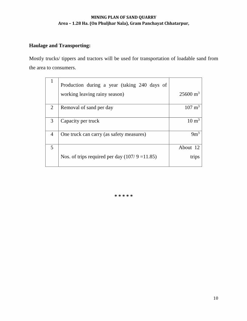
Haulage and Transporting:
Mostly trucks/ tippers and tractors will be used for transportation of loadable sand from
the area to consumers.
1 Production during a year (taking 240 days of
working leaving rainy season)
25600 m3
2 Removal of sand per day 107 m3
3 Capacity per truck 10 m3
4 One truck can carry (as safety measures) 9m3
5
Nos. of trips required per day (107/ 9 =11.85)
About 12
trips
* * * * *

MINING PLAN OF SAND QUARRY
Area – 1.28 Ha. (On Phuljhar Nala), Gram Panchayat Chhatarpur,
11
CHAPTER- 5 (b)
MANPOWER DEPLOYMENT
State average daily employment and statutory personals:
Unskilled 39 labors will be required for loading tractors/ trucks and skilled 1 person
required for supervision purpose.
* * * * *

MINING PLAN OF SAND QUARRY
Area – 1.28 Ha. (On Phuljhar Nala), Gram Panchayat Chhatarpur,
12
CHAPTER- 5 (c)
USE OF MINERAL
Describe the utilization of mineral and type of industry.
Sand so extracted will be sold locally as building material. It is usually mixed with
cement and other ingredients to create mortar for building. It is also used in bricks
industry.
* * * * *

MINING PLAN OF SAND QUARRY
Area – 1.28 Ha. (On Phuljhar Nala), Gram Panchayat Chhatarpur,
13
CHAPTER-6
WASTE DISPOAL ARRANGEMENTS
No waste material will be generated hence waste disposal arrangements are not required.
*******

MINING PLAN OF SAND QUARRY
Area – 1.28 Ha. (On Phuljhar Nala), Gram Panchayat Chhatarpur,
14
CHAPTER-7
RECLAMATION PLAN
The removal of sand from the Nala bed only, without disturbing the water flow and the
water level in the Nala area under study. Phuljhar Nala that is a seasonal source of water.
The sand removed from the area will be automatically accumulated / filled up during
rainy season.
This is an automatic natural activity hence special plan for reclamation of the area is not
required.
Plantation will be carried preferably on the Nala bank and along the road used for
transportation or the area proposed by the Gram Panchayat.
As discussed earlier the area of sand removal is the Phuljhar Nala bed. Hence, no specific
land use pattern and reclamation plan is required.
* * * * *

MINING PLAN OF SAND QUARRY
Area – 1.28 Ha. (On Phuljhar Nala), Gram Panchayat Chhatarpur,
15
CHAPTER-8
STRATEGY FOR PROTECTION OF RIVER COURSE, NALAS, WATER TANK,
VILLAGES, IMPORTANT MONUMENTS, IF ANY
Briefly outline the proposed strategies (if any) for protection of following:
(a) River: Sand only be removed 2meter above water level without disturbing the water
flow, hence any strategy for protection to save river course is not required. The
proposed plantation on the river bank will be taken up to protect embankment.
(b) Nala: Nalas are not affected, as they are untouched during removal of sand from the
area.
(c) Water Tank: The area located in the Phuljhar Nala bed is sufficiently away from
sensitive man made land uses like water tanks, hospitals.
(d) Village / houses / hutment: The project will have no effect on any type class of
vulnerable people and being no requirement of agricultural material during any phase
of project, no wastes will be generated.
(e) Important monument: There is no important monument within the 10 km radius
from the lease area.
* * * * *

MINING PLAN OF SAND QUARRY
Area – 1.28 Ha. (On Phuljhar Nala), Gram Panchayat Chhatarpur,
16
CHAPTER-9
ANY OTHERS RELEVANT INFORMATION
No other relevant information is required.
* * * * *
Applicant Signature of authorized person
Gram Panchayat Chhatarpur

MINING PLAN OF SAND QUARRY
Area – 1.28 Ha. (On Phuljhar Nala), Gram Panchayat Chhatarpur,
17