MICK GEORGE LTD. PROPOSED RINGSTEAD GRANGE QUARRY · MICK GEORGE LTD. PROPOSED RINGSTEAD GRANGE...
143
DAB Geotechnics MICK GEORGE LTD. PROPOSED RINGSTEAD GRANGE QUARRY HYDROLOGICAL AND HYDROGEOLOGICAL ASSESSMENT DAB Geotechnics
Transcript of MICK GEORGE LTD. PROPOSED RINGSTEAD GRANGE QUARRY · MICK GEORGE LTD. PROPOSED RINGSTEAD GRANGE...

DAB Geotechnics
MICK GEORGE LTD.
PROPOSED RINGSTEAD GRANGE QUARRY HYDROLOGICAL AND HYDROGEOLOGICAL ASSESSMENT
DAB Geotechnics

Proposed Ringstead Grange Quarry - Hydrological and Hydrogeological Assessment
DABGeot/11093/Final
PROPOSED RINGSTEAD GRANGE QUARRY HYDROLOGICAL AND HYDROGEOLOGICAL ASSESSMENT February 2012
Name Signature Date
Prepared by D. A. Blythe 10th February 2012
Issue Status Final Purpose For Client’s information
Prepared by DAB Geotechnics
3, Tweed Avenue, Ellington, MORPETH,
Northumberland, NE61 5ES Tel. No. 07711 168524
E-mail [email protected]
Proposed Ringstead Grange Quarry - Hydrological and Hydrogeological Assessment
DABGeot/11093/Final
i
PROPOSED RINGSTEAD GRANGE QUARRY HYDROLOGICAL AND HYDROGEOLOGICAL ASSESSMENT Table of Contents Page 1. INTRODUCTION 1
1.1 General 1 1.2 Location 2 1.3 Topography 2 1.4 Development Proposal 2
2. GEOLOGY 3
2.1 Published Information 3 2.2 Exploratory Drilling 3 2.3 General Succession 3
2.3.1 Superficial Deposits 3 2.3.2 Bedrock Strata 5
2.4 Geological Structure 8 2.5 Mining and Ground Stability 8
2.5.1 General 8 2.5.2 Mining Stability 8 2.5.3 Ground Stability 8
3. HYDROLOGY 9
3.1 Rainfall 9 3.2 Catchment and Principal Drainage Paths 9 3.3 Site Specific Drainage Details 10 3.4 Flood Risk 10 3.5 Greenfield Runoff Rate 10 3.6 Licensed and Unlicensed Surface Water Abstractions 11 3.7 Surface Water Discharges 12 3.8 Surface Water Quality 12
4. HYDROGEOLOGY 14
4.1 Environment Agency Classification 14 4.2 Hydraulic Properties of the Strata 14
4.2.1 Superficial Deposits 14 4.2.2 Bedrock Strata 14

Proposed Ringstead Grange Quarry - Hydrological and Hydrogeological Assessment
DABGeot/11093/Final
ii
Page
4.3 Exploratory Borehole Information and Groundwater Monitoring Stations 15 4.4 Groundwater Quality 17 4.5 Licensed and Unlicensed Groundwater Abstractions 17 4.6 Waste Handling, Disposal and Treatment Sites and Waste Transfer Stations 18
5. PREDICTED EFFECTS OF PROPOSED QUARRY DEVELOPMENT AND 19
MITIGATION MEASURES 5.1 Management of Water on the Proposed Quarry Site 19 5.2 Groundwater Resources 19
5.2.1 Estimated Groundwater Inflow Rates 19 5.2.2 Effect of Drawdown 21 5.2.3 Swelling and Shrinkage of Bedrock Strata 22 5.2.4 Settlement of Backfill 22 5.2.5 Groundwater Quality 23
5.3 Surface Water Resources 23
5.3.1 Flood Risk 23 5.3.2 Attenuation Storage Volumes 24 5.3.3 Flooding of Station Road 26 5.3.4 Surface water Abstractions 26 5.3.5 Surface Water Quality 26
6. SUMMARY 27 7. REFERENCES 28 FIGURES PHOTOGRAPHS APPENDIX A LANDMARK ENVIROCHECK REPORT ABBENDIX B CORRESPONDENCE WITH EAST NORTHAMPTONSHIRE COUNCIL APPENDIX C SCOPING OPINION FROM THE ENVIRONMENT AGENCY APPENDIX D 1/10,000 SCALE GEOLOGICAL MAPS APPENDIX E BGS ARCHIVE BOREHOLE RECORDS APPENDIX F MINING AND GROUND STABILITY REPORT APPENDIX G PPS25 FLOOD RISK ASSESSMENT APPENDIX H ATTENUATION STORAGE CALCULATIONS

Proposed Ringstead Grange Quarry - Hydrological and Hydrogeological Assessment
DABGeot/11093/Final 1
1. INTRODUCTION 1.1 General
Mick George Ltd. (Mick George) proposes to extract limestone at its Ringstead Grange site and restore the exhausted workings using imported inert fill materials. DAB Geotechnics was appointed by Mick George to undertake a hydrological and hydrogeological assessment of the proposed quarry. The study has entailed: (i) the provision of a Landmark, ‘Envirocheck’, report to determine the location of all
licensed surface and groundwater abstractions, discharge consents, landfill sites and pollution incidents at distances of up to 2km from the centre of the site (Appendix A);
(ii) liaison with the East Northamptonshire Council with regard to the location of any unlicensed (private) water supplies within at least 1km of the site (Appendix B);
(iii) reference to the scoping opinion provided by the Environment Agency in its letter to
Northamptonshire County Council dated 8th November 2011 (ref. no. AN/2011/113241/01-L02), a copy of which is presented in Appendix C.
(iv) an examination of the geological maps and reports published by the British Geological
Survey (BGS) and the provision of an Envirocheck report based on 1/10,000 scale digital information (Appendix D);
(v) reference to a number of relevant borehole logs held on the BGS GeoRecords archive
(Appendix E); (vi) the acquisition of an Envirocheck mining and ground stability report (Appendix F);
(vii) an examination of the most recent aerial photographs; (viii) the compilation of a flood risk assessment in accordance with Planning Policy Statement
(PPS) 25 (Department for Communities and Local Government, 2010) (Appendix G); and
(ix) an assessment of the possible effects on surface and groundwater resources and the
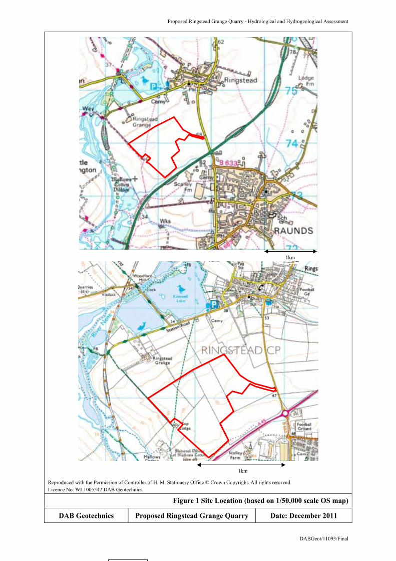
mitigation measures that will be undertaken. 1.2 Location The proposed development is located about 1.5km south-west of Ringstead and 2km north-west of
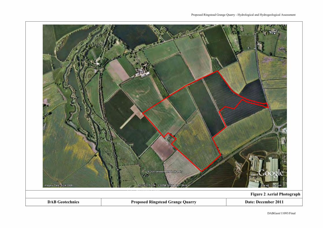
Raunds in an area administered by East Northamptonshire and Northamptonshire County Councils (Figure 1). The site comprises arable agricultural land and is bounded along its south-eastern margin by a wooded valley that lies adjacent to the A45 public road. Access to the quarry will be gained from the B663 (Raunds or London Road) located to the north-east. The Grid Reference for the centre of the site has been taken as 498050 273900 (1/50,000 scale Ordnance Survey Map Sheet 141 Kettering, Corby & Surrounding Area). An aerial photograph is presented as Figure 2.

Proposed Ringstead Grange Quarry - Hydrological and Hydrogeological Assessment
DABGeot/11093/Final 2
1.3 Topography
The site occupies an area of 64.3 hectares and is located in an area of gently undulating land. Surface elevations range from about 66m above Ordnance Datum (AOD) in the east to 53m AOD in the west and fall towards the north-west, west and south-west.
1.4 Development Proposal Details of the proposed working scheme for the quarry are contained within the Environmental Statement and are shown on the Working Scheme Plan (Dwg. No. R15/03) and the Indicative Phasing Plans (Dwg. Nos. R15/05). The quarry excavations will cover an area of about 52 hectares and will be worked in a south-westerly and then north-easterly direction along a succession of NW-SE aligned cuts or development phases. The soils will be stripped in a progressive fashion. The initial volumes will be temporarily stored, but the remainder will be placed directly to bed as the exhausted workings are backfilled to restoration level using overburden, quarry discard and imported inert materials. The existing topography and landform will be largely replicated. The development has been designed to minimize the area of disturbance at each stage of the development with land either remaining in agricultural production or restored for that use. Surface runoff will be further attenuated by creating a number of wetland areas of ecological interest (Conceptual Restoration Plan, Dwg. No. R15/04). Surface runoff from the working areas and any groundwater abstracted from the excavations will be pumped and drained to settlement lagoons. The treated water will be discharged into an unnamed tributary of Hog Dyke, subject to the consent of the Environment Agency. Surface runoff from the restored areas that will be created in the northern part of the site will be drained to newly created wetland areas and to the existing agricultural drainage system. Measures will be taken to alleviate a problem of minor flooding of Station Road adjacent to the cemetery.
Proposed Ringstead Grange Quarry - Hydrological and Hydrogeological Assessment
DABGeot/11093/Final 3
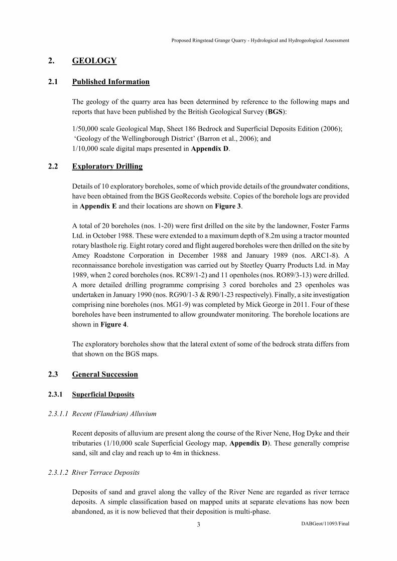
2. GEOLOGY 2.1 Published Information
The geology of the quarry area has been determined by reference to the following maps and reports that have been published by the British Geological Survey (BGS):
1/50,000 scale Geological Map, Sheet 186 Bedrock and Superficial Deposits Edition (2006); ‘Geology of the Wellingborough District’ (Barron et al., 2006); and 1/10,000 scale digital maps presented in Appendix D.
2.2 Exploratory Drilling Details of 10 exploratory boreholes, some of which provide details of the groundwater conditions, have been obtained from the BGS GeoRecords website. Copies of the borehole logs are provided in Appendix E and their locations are shown on Figure 3.
A total of 20 boreholes (nos. 1-20) were first drilled on the site by the landowner, Foster Farms
Ltd. in October 1988. These were extended to a maximum depth of 8.2m using a tractor mounted rotary blasthole rig. Eight rotary cored and flight augered boreholes were then drilled on the site by Amey Roadstone Corporation in December 1988 and January 1989 (nos. ARC1-8). A reconnaissance borehole investigation was carried out by Steetley Quarry Products Ltd. in May 1989, when 2 cored boreholes (nos. RC89/1-2) and 11 openholes (nos. RO89/3-13) were drilled. A more detailed drilling programme comprising 3 cored boreholes and 23 openholes was undertaken in January 1990 (nos. RG90/1-3 & R90/1-23 respectively). Finally, a site investigation comprising nine boreholes (nos. MG1-9) was completed by Mick George in 2011. Four of these boreholes have been instrumented to allow groundwater monitoring. The borehole locations are shown in Figure 4.
The exploratory boreholes show that the lateral extent of some of the bedrock strata differs from
that shown on the BGS maps. 2.3 General Succession 2.3.1 Superficial Deposits 2.3.1.1 Recent (Flandrian) Alluvium
Recent deposits of alluvium are present along the course of the River Nene, Hog Dyke and their tributaries (1/10,000 scale Superficial Geology map, Appendix D). These generally comprise sand, silt and clay and reach up to 4m in thickness.
2.3.1.2 River Terrace Deposits
Deposits of sand and gravel along the valley of the River Nene are regarded as river terrace deposits. A simple classification based on mapped units at separate elevations has now been abandoned, as it is now believed that their deposition is multi-phase.

Proposed Ringstead Grange Quarry - Hydrological and Hydrogeological Assessment
DABGeot/11093/Final 4
The Nene Valley Formation encompasses three river deposits of which only two have been identified in the area of interest. The Ecton Member or, ‘first terrace’, extends about 2m above the present floodplain and is overlain by recent alluvium. The gravel fraction comprises about 32% flint, 28% quartzite, 38.5 % local ironstone, sandstone and limestone and 1.5% chalk. The deposits reach a maximum thickness of about 4.5m. The Grendon Member or, ‘second terrace’, is much more restricted in extent. Its surface lies between 5 and 9m above the present floodplain. The deposits reach a maximum thickness of 7.6m and have a similar composition to the Ecton Member. The 1/10,000 scale Superficial Geology map in Appendix D shows that sand and gravel of the Ecton Member are present to the north-west of Ringstead Grange Farm and some distance to the south of the site. The deposits have been exploited and flooded workings extend to the west of Ringstead village (Figure 1).
2.3.1.3 Glacial Till and Glacio-Fluvial Sand and Gravel Two glacial tills have been mapped in the Ringstead area: an upper till that is correlated with the
Oadby Till and a lower one named the Bozeat Till. The relationship between these strata is uncertain as no intervening organic deposits have yet been recorded. They may represent deposits of discrete glacial events or merely different facies of the Oadby Till.
The Bozeat Till is a dark bluish grey diamicton consisting of sandy, silty clay with clasts of mainly
Jurassic limestone and ironstone, some quartz and quartzite, rare flint and chalk. A maximum thickness of 5m has been recorded that always underlies the Oadby Till. The latter closely resembles the, ‘Chalky Boulder Clay’, of central and south-east England. It commonly reaches up to 15m in thickness. It is an olive grey to grey diamicton that weathers to yellowish brown and comprises silty clay with abundant clasts of chalk, flint, Jurassic limestone, sandstone and ironstone, quartz, quartzite and Carboniferous limestone and sandstone.
Glacio-fluvial sand and gravel occur as sparsely distributed discontinuous bodies resting on,
within and beneath both tills. The clasts comprise Jurassic limestone, sandstone and ironstone, flint, quartz and quartzite and locally chalk.
The 1/10,000 scale Superficial Geology map in Appendix D shows that Bozeat and Oadby Tills
are present in the eastern part of the site. Deposits of glacio-fluvial sand and gravel are recorded in its northernmost part.
. 2.3.1.4 Made Ground The 1/10,000 scale Artificial Ground and Landslip map in Appendix D shows that there are a
number of areas of made ground in the Ringstead area. Those labelled WMGR refer to backfilled ironstone workings in the Northampton Sand Formation (Section 2.3.2.3), one of which is located along the northern margin of the site.

Proposed Ringstead Grange Quarry - Hydrological and Hydrogeological Assessment
DABGeot/11093/Final 5
2.3.2 Bedrock Strata 2.3.2.1 General
It is proposed to extract limestone from the Cornbrash and Blisworth Limestone Formations. The limestones form part of a sedimentary succession of Jurassic age, details of which are provided in Table 1. Fuller descriptions are provided below in ascending order. The 1/10,000 scale Bedrock and Faults map in Appendix D shows the lateral extent of the various formations.
Group Formation
Proven Thickness on Site (m)
Upper Jurassic
Ancholme Group Oxford Clay Not present
Middle Jurassic
Kellaways 2.25
Great Oolite Group
Cornbrash Blisworth Clay Blisworth Limestone Rutland (Upper & Lower Estuarine Series)
0.50-1.78 3.30-4.35 4.90-5.93 3.55-4.98
Inferior Oolite Group Northampton Sand 4.95-5.85
Lower Jurassic Lias Group Whitby Mudstone >1.10
Table 1 Details of the Stratigraphic Succession at the Proposed Quarry 2.3.2.2 Lias Group The Whitby Mudstone Formation forms the uppermost part of the Lias Group and comprises a
bluish grey mudstone with thin limestones towards its base. It varies in thickness from 35 to 56m. 2.3.2.3 Inferior Oolite Group The Inferior Oolite Group is entirely represented in the area by the Northampton Sand Formation.
The constituent sideritic limestone has been widely quarried as a source of building material and iron ore. The deposit ranges in thickness from 4 to 6m.
2.3.2.4 Great Oolite Group The Great Oolite Group rests unconformably on the eroded surface of the Northampton Sand or
Whitby Mudstone Formations. The Rutland Formation can reach up to 15m in thickness, but only 3.55 to 4.98m has been proved on the site. The basal Stamford Member comprises a pale to dark grey and black sandy mudstone with ironstone bands. This is overlain by pale grey fine to medium grained sandstone. The overlying sediment consists of a rhythmic succession of mudstones and sandstones, including a calcareous mudstone and limestone horizon known as the Wellingborough Limestone Member.

Proposed Ringstead Grange Quarry - Hydrological and Hydrogeological Assessment
DABGeot/11093/Final 6
The Blisworth Limestone Formation was deposited in shallow marine lagoons following transgression. It is typically 5 to 6m thick and is separated into two members. The Roade Member consists of interbedded argillaceous, bioclastic packstone, wackestone and lime mudstone. It measures some 1.8m in thickness. The overlying Irchester Member is dominated by ooidal and peloidal limestones with interbedded lime mudstone beds. The overlying Blisworth Clay Formation comprises a smooth plastic mudstone, characteristically variegated in colour and showing blue green, magenta and purple mottling. It lies unconformably on the limestone. The irregularly bedded bioclastic packstones and grainstones of the Cornbrash Formation form the uppermost part of the Great Oolite Group.
2.3.2.5 Ancholme Group The Kellaways Formation is divided into the basal Kellaways Clay Member, which comprises dark
grey mudstone, and the overlying Kellaways Sand Member. The latter consists of a sequence of pale grey, fine grained sand or sandstone, siltstone and mudstone. The Oxford Clay Formation has only been mapped in the easternmost part of the site. Its basal part consists of dark brownish grey mudstone.
2.3.2.6 BGS GeoRecords Borehole Data
A summary of the borehole logs obtained from the BGS GeoRecords database is given in Table 2. Copies of the logs are provided in Appendix E.

Proposed Ringstead Grange Quarry - Hydrological and Hydrogeological Assessment
DABGeot/11093/Final 7
BGS Ref. No.
Grid Ref. Location/Name Surface Level
/Depth Date
Drilled
Summary of Strata (with interpretations)
Borehole Description Formation
SP97NE164 499130 275640 Ringstead 60.70m AOD/
3.00m bgl August 1974
0.09m Topsoil. 1.20m Clay, yellowish brown, sandy. 0.90m Limestone.
Blisworth Limestone
SP97SE1 498300 274730
Caprons Ringstead Estate No. 3
52.12m AOD/ 5.00m bgl 1939 3.96m Baring (clay & mudstone).
1.83m Ironstone. Northampton Sand
SP97SE4 497540 274000
Caprons Ringstead Royalty
55.47m AOD/ 6.00m bgl 1940 4.72m Baring (clay & mudstone).
1.83m Ironstone. Northampton Sand
SP97SE16 498500 273950
Addington II SA 12D/2150
60.24m AOD/ 31.39m bgl 16/10/41
0.30m Topsoil 4.57m Mixed clay 3.05m Grey sand 1.52m Grey clay 0.30m Claystone 0.91m Limestone 2.44m Mixed clay 0.91m Brown clay 6.10m Limestone 1.52m Grey clay 1.83m Grey Sand 0.61m Hard grey sand 2.13m Black sand 4.88m Ironstone 0.30m Grey clay
Oxford Clay ) Kellaways ) ) Cornbrash ) ) Blisworth Clay ) Blisworth Limestone ) ) Rutland ) ) Northampton Sand Whitby Mudstone
SP97SE47 497440 274330
Caprons Ringstead Estate No. Th. 1 5.03m bgl 1940 2.59m Baring (clay & mudstone).
2.44m Ironstone. Northampton Sand
SP97SE48 498080 274630
Caprons Ringstead Estate No. Th. 2 5.00m bgl 1940 4.11m Baring (clay & mudstone).
1.52m Ironstone. Northampton Sand
SP97SE112 497760 272820 Raunds 33.53m AOD/
5.30m bgl November
1974
0.2m Topsoil. 3.30m Clay, variegated, silty with peat partings below 2.80m. 1.40m Sand and gravel. (Gravel - fine to coarse, angular and subangular limestone, ironstone, quartzite and flint. Sand - medium to coarse.) 0.40m Clay, stiff, blue-grey.
SP97SE115 498050 274950 Ringstead 33.83m AOD/
5.40m bgl November
1974
0.9m Topsoil 4.50m Clayey, sandy gravel (Gravel - fine with coarse, subangular, ironstone, limestone and flint. Sand - fine to coarse.)
SP97SE116 498860 274330 Raunds 69.80m AOD/
8.90m bgl May 1974 0.40m Topsoil. 6.00m Clay, brown and grey, chalky with sand partings. 2.50m Clay, firm, blue-grey, silty.
Oxford Clay
SP97SE124 497790 272800
Meadow Road, Raunds
35.36m AOD/ 43.40m bgl 1896
1.22m Loamy clay. 3.66m Gravel. 26.82m Blue clay. 0.61m Argillaceous limestone. 1.07m Hard clay. 0.46m Oolitic rock. 1.37m Dark blue indurated clay. 1.07 Argillo-calcareous rock, grey or brown, with rounded pebbles. 7.11m Clay with thin limestone bands and nodules.
) ) ) Whitby Mudstone ) ) ) ) Marlstone Rock ) )
bgl – below ground level
Table 2 Summary of Borehole Data from BGS GeoRecords Archive

Proposed Ringstead Grange Quarry - Hydrological and Hydrogeological Assessment
DABGeot/11093/Final 8
2.4 Geological Structure
The structure of the Jurassic strata at the proposed quarry site generally conforms to the regional south-south-easterly dip of less than half a degree (1v in 115h). This may be modified by flexuring or the effects of faulting or superficial structures. A number of minor faults have been recorded on the site. These trend NW-SE and are shown on the 1/10,000 scale maps which are presented in Appendix D. The bedrock strata are dissected by at least two, subvertical joint sets.
2.5 Mining and Ground Stability 2.5.1 General
A mining and ground stability report has been obtained for the site and a copy is provided in Appendix F.
2.5.2 Mining Stability
There are no records of any underground workings in the Northampton Sand Formation (ironstone), but backfilled surface excavations are present to the north-west of the site (1/10,000 scale Artificial Ground and Landslip map, Appendix D). Sand and gravel has been extracted along the valley of the River Nene and the limestone has also been recovered from the Cornbrash Formation at Scalley Farm Pit, Raunds (Grid Ref. 498939 273551). The exhausted sand and gravel workings are considered to represent a site of special scientific interest (SSSI) with the majority classified as a Ramsar site and the remainder as a local nature reserve.
2.5.3 Ground Stability
The BGS National Geoscience Information Service states that there is no potential for compressible ground stability hazards on the site and that the potential for instability due to collapsible ground, landslide, ground dissolution and running sand is low to very low. The potential for compressible ground stability reaches moderate levels in those areas of backfilled ironstone workings because the backfill was not compacted during its placement. There is, however, no surface expression of any recent settlement. There is no evidence of significant karstification of the Cornbrash and Blisworth Limestone Formations, but there remains a potential for dissolution, more so where they lie close to ground surface. The potential for shrinking or swelling clay ranges from zero to moderate, dependent upon the sub-surface strata. The 1/10,000 scale geological maps in Appendix D indicate that the areas of moderate risk are linked to the outcrop of the Blisworth Clay Formation. The Rutland Formation and the superficial cover of glacial till form areas of low risk. The 1/50,000 scale map provided in Appendix F confirms that the potential is low in the area around Ringstead village.

Proposed Ringstead Grange Quarry - Hydrological and Hydrogeological Assessment
DABGeot/11093/Final 9
3. HYDROLOGY 3.1 Rainfall The long term average annual rainfall at the proposed quarry site is approximately 612mm
(NERC, 1999). 3.2 Catchment and Principal Drainage Paths
The catchment boundaries for the site have been determined using the Flood Estimation Handbook CD-ROM (NERC, 1999) and are shown in Figure 5. The catchment characteristics are provided in Table 3. Surface runoff is ultimately directed to an unnamed ephemeral stream located along the south-eastern boundary of the site. This flows in a south-westerly direction and joins Hog Dyke before discharging into the River Nene at Grid Ref. 496900 273850. The river flows in a north-north-easterly direction.
Parameters Catchment Description 1 2
Catchment drainage area (km2). Index of flood attenuation due to reservoirs and lakes. Index of proportion of time that soils are wet. Mean catchment altitude (m above sea level). Index representing the dominant aspect of catchment slopes. Index describing the invariability in aspect of catchment slopes. Base flow index derived using the HOST classification. Index describing catchment size and drainage path configuration (km). Index of catchment steepness (m/km). Longest drainage path (km). Median annual maximum 1 hour rainfall (mm). Median annual maximum 1 day rainfall (mm). Median annual maximum 2 day rainfall (mm). 1961-90 standard period average annual rainfall (mm) 1941-70 standard period average annual rainfall (mm) Standard percentage runoff derived using HOST classification. Index of concentration of urban and suburban land cover. FEH index of fractional urban extent (1990) Index of location of urban and suburban land cover.
Note. UK soils have been delineated according to their hydrological properties to produce the twenty-nine class Hydrology of Soil Types (HOST) classification. The HOST dataset is available as a 1km grid which records, for each grid square, the percentage of the 1km x 1km area given to each HOST class present. Boorman et al. (1995) give standard percentage runoff (SPR) and base flow index (BFI) values for each HOST class.
Table 3 Catchment Characteristics (as determined using FEH CD-ROM (NERC, 1999))

Proposed Ringstead Grange Quarry - Hydrological and Hydrogeological Assessment
DABGeot/11093/Final 10
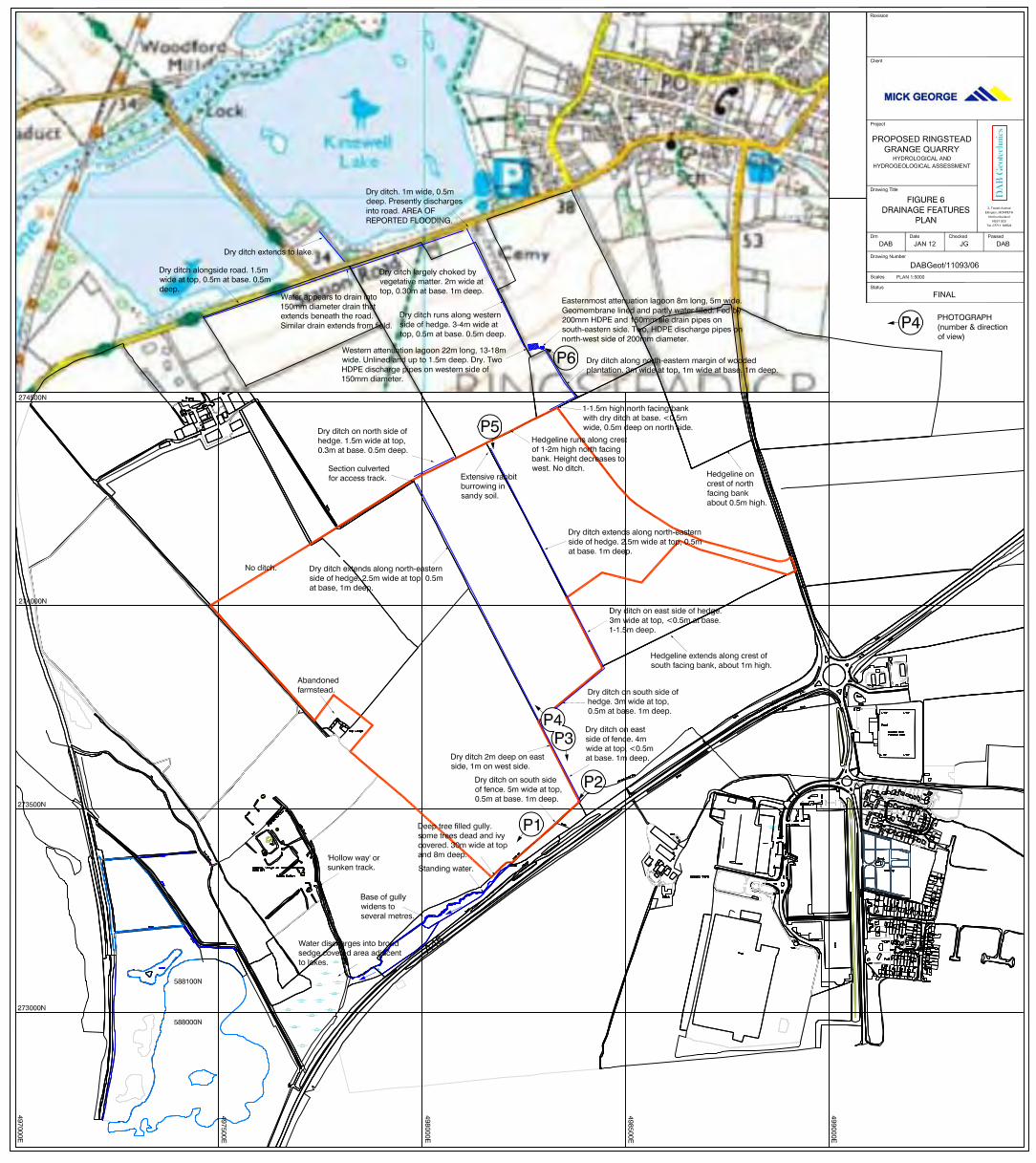
3.3 Site Specific Drainage Details
The site presently comprises arable land and it is assumed that a network of agricultural tile drains has been installed. There are no plans of the drainage system, but the site was inspected on the 8th December 2011 and a number of open ditches recorded, details of which are shown on Figure 6. Attention is also drawn to Photographs P1 to P5. There is no evidence to suggest the development of karstic features in the Cornbrash and Blisworth Limestone Formations. A number of flooded sand and gravel workings are present to the north of Ringstead Grange Farm along the Nene valley.
3.4 Flood Risk
Extracts of the Environment Agency Flood Map, which are presented in Appendix A, indicate
that the proposed Ringstead Grange site lies in Flood Zone 1 having less than 1 in a 1,000 year annual probability of flooding (i.e. <0.1%). A flood risk assessment has been carried out in accordance with Planning Policy Statement (PPS) 25 (Department for Communities and Local Government, 2010) following the latest guidance notes (Department for Communities and Local Government, 2009). Details are provided in Appendix G. The assessment concludes, amongst other things, that the development will not increase the risk of downstream flooding.
3.5 Greenfield Runoff Rate
The greenfield runoff rate for the site has been determined using the methodology described in the Institute of Hydrology Report No. 124 (NERC, 1994). The calculations are as follows and are presented in Table 4.
Area: 64.3 hectares or 0.643 km2 Average Annual Rainfall for quarry: 612mm. Soil Factor: 0.37 (soil partly derived from glacial till). Average flow (QBAR): 0.154 m3/s from 64.3 hectares or 2.4 l/s/ha Hydrometric area 5
(NERC, 1999)
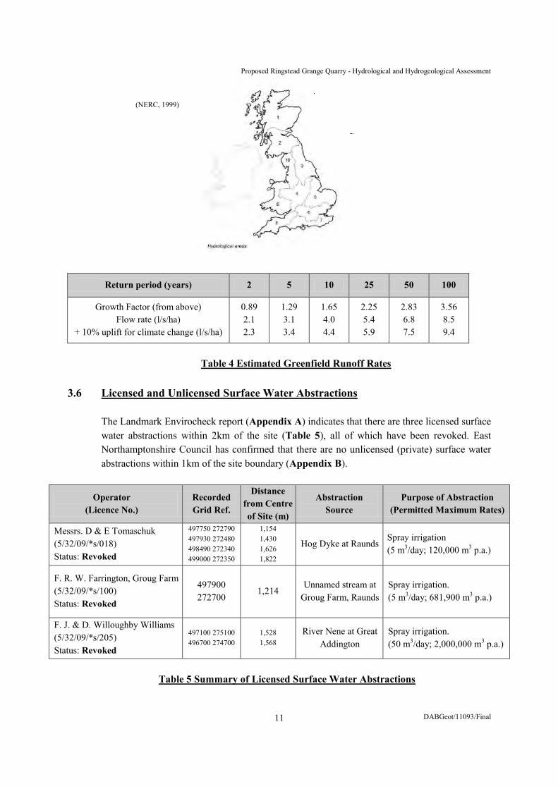
Proposed Ringstead Grange Quarry - Hydrological and Hydrogeological Assessment
DABGeot/11093/Final 11
Return period (years) 2 5 10 25 50 100
Growth Factor (from above) Flow rate (l/s/ha)
+ 10% uplift for climate change (l/s/ha)
0.89 2.1 2.3
1.29 3.1 3.4
1.65 4.0 4.4
2.25 5.4 5.9
2.83 6.8 7.5
3.56 8.5 9.4
Table 4 Estimated Greenfield Runoff Rates
3.6 Licensed and Unlicensed Surface Water Abstractions The Landmark Envirocheck report (Appendix A) indicates that there are three licensed surface
water abstractions within 2km of the site (Table 5), all of which have been revoked. East Northamptonshire Council has confirmed that there are no unlicensed (private) surface water abstractions within 1km of the site boundary (Appendix B).
Operator (Licence No.)
Recorded Grid Ref.
Distance from Centre of Site (m)
Abstraction Source
Purpose of Abstraction (Permitted Maximum Rates)
Messrs. D & E Tomaschuk (5/32/09/*s/018) Status: Revoked
497750 272790 497930 272480 498490 272340 499000 272350
1,154 1,430 1,626 1,822
Hog Dyke at Raunds Spray irrigation (5 m3/day; 120,000 m3 p.a.)
F. R. W. Farrington, Groug Farm (5/32/09/*s/100) Status: Revoked
497900 272700
1,214 Unnamed stream at
Groug Farm, Raunds Spray irrigation. (5 m3/day; 681,900 m3 p.a.)
F. J. & D. Willoughby Williams (5/32/09/*s/205) Status: Revoked
497100 275100 496700 274700
1,528 1,568
River Nene at Great Addington
Spray irrigation. (50 m3/day; 2,000,000 m3 p.a.)
Table 5 Summary of Licensed Surface Water Abstractions
(NERC, 1999)

Proposed Ringstead Grange Quarry - Hydrological and Hydrogeological Assessment
DABGeot/11093/Final 12
3.7 Surface Water Discharges
The Landmark Envirocheck report (Appendix A) confirms that there three consented discharges within 1km of the centre of the quarry site (Table 6).
Permit/Licence Holder (Reference No.)
Recorded Grid Ref.
Approximate Distance
from Centre of Site (m)
Discharge Type Receiving Watercourse
Kier Warth Ltd., Warth Park, London Road, Raunds (Pmnf12044)
498600 273550 655 Sewage Discharges Roadside Ditch,
Tributary of Hog Dyke
Mr. H. Foster, Cotton Farm, Ringstead (Pr5nf2184)
497400 274500 882 Unknown Not supplied
Evans & Son, Wooton Green Farm, Wooton, Bedfordshire (Pr1nfg0458)
499000 274000 955 Discharge of other
matter-surface water Wooton Brook
Table 6 Summary Details of Environmental Permits/Discharge Consents
3.8 Surface Water Quality
The Landmark Envirocheck report provides some details as to the quality of the water in Hog Dyke: Class C at Grid Ref. 498441 273450 and Class D at 497234 273448 in the year 2000. The Environment Agency’s internet website provides the following information with regard to the quality of the River Nene (Table 7).
Upstream Grid Ref.
Downstream Grid Ref.
Length of Reach
495700 270600
497400 275200
9km
Year Ammonia Dissolved Oxygen Nitrates Phosphates 2009 2008 2007 2006 2005 2004 2002 2001 2000 1997 1995 1993 1990
A A A A A A B A A B B C C
B B B B B B B A B C B C E
5 5 6 6 6 6 5 5 6
6
6
5 5 5 5 5 5 5 5 5
6
6 Ammonia and dissolved oxygen - A to F (very good to bad) Nitrates and phosphates - 1 to 6 (very low to very high levels)
Table 7 Summary of Water Quality Data for the River Nene (Environment Agency Website)

Proposed Ringstead Grange Quarry - Hydrological and Hydrogeological Assessment
DABGeot/11093/Final 13
The website also indicates that the ecological and chemical quality of the river is classified as moderate and good respectively at Grid Ref. 497414 275188. However, the ammonia, copper, iron and zinc concentrations are presently considered to be high. The same comments are made with regard to Hog Dyke. There are records of only one pollution incident to surface waters in the search area (13th August 1992, no. 1442). These refer to the Hog Dyke at Grid Ref. 497400 273500. The source of the pollution was not found, but the incident was considered to be significant (Category 2). The Environment Agency’s internet website provides details of two incidents near Woodford and Ringstead villages. These are summarized in Table 8.
Incident No.
Grid Ref.
Date Local Authority Pollutant Environmental Impact
Impact
To Land To Water
302060 498229 275230
30/03/05 East Northamptonshire Sewage Significant Minor Significant
317372 499086 272351
03/06/05 East Northamptonshire Sewage Significant None Significant
Table 8 Summary of Pollution Incidents from the Environment Agency’s Website
The proposed quarry site and the search area used in this study will form part of an Environment Agency Nitrate Vulnerability Zone as from the 1st January 2013.

Proposed Ringstead Grange Quarry - Hydrological and Hydrogeological Assessment
DABGeot/11093/Final 14
4. HYDROGEOLOGY 4.1 Environment Agency Classifications
The Environment Agency has assigned the following classifications to the soil and bedrock formations: Alluvium Secondary A Aquifer Bozeat and Oadby Tills Unproductive Glacio-fluvial Sand and Gravel Secondary A Aquifer Oxford Clay Formation Unproductive Kellaways Sand Member Secondary A Aquifer Kellaways Clay Member Unproductive Cornbrash Formation Secondary A Aquifer Blisworth Clay Formation Unproductive Blisworth Limestone Formation Principal Aquifer Rutland Formation Unproductive or Secondary B Aquifer* Northampton Sand Formation Secondary A Aquifer Whitby Mudstone Formation Unproductive (*where Wellingborough Limestone Member is present) The mapped locations of these strata are shown in Appendices A and D. There are no source protection zones on the site or within 1km of its boundary.
4.2 Hydraulic Properties of Strata 4.2.1 Superficial Deposits
The deposits of glacial till will have a very low hydraulic conductivity, typically less than 10-9 m/s, and where present this will greatly inhibit the infiltration of the underlying bedrock. The conductivity of the glacio-fluvial deposits will be much higher, possibly falling within the range 10-3 to 10-5 m/s, and as such will allow greater infiltration.
4.2.2 Bedrock Strata
Groundwater flow in the bedrock strata will be largely confined to natural joints and fissures, most especially in the limestones. There is no evidence of significant karstification, although it is entirely possible that some dissolution has occurred along the joint planes. Nevertheless, the mass permeability could be of the order of 10-6 m/s. It is expected that Blisworth Limestone and Cornbrash Formations will be largely confined by the underlying and overlying deposits of mudstone.
Proposed Ringstead Grange Quarry - Hydrological and Hydrogeological Assessment
DABGeot/11093/Final 15
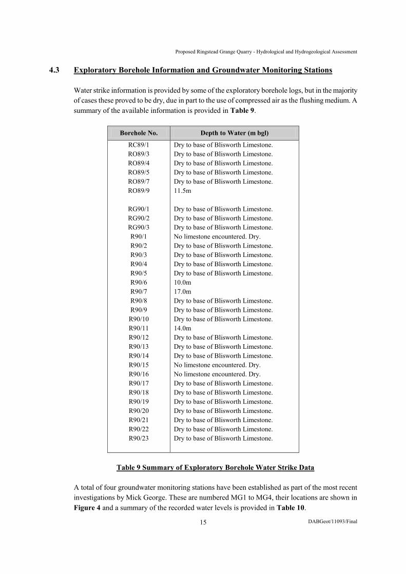
4.3 Exploratory Borehole Information and Groundwater Monitoring Stations
Water strike information is provided by some of the exploratory borehole logs, but in the majority of cases these proved to be dry, due in part to the use of compressed air as the flushing medium. A summary of the available information is provided in Table 9.
Borehole No. Depth to Water (m bgl)
RC89/1 RO89/3 RO89/4 RO89/5 RO89/7 RO89/9
RG90/1 RG90/2 RG90/3 R90/1 R90/2 R90/3 R90/4 R90/5 R90/6 R90/7 R90/8 R90/9
R90/10 R90/11 R90/12 R90/13 R90/14 R90/15 R90/16 R90/17 R90/18 R90/19 R90/20 R90/21 R90/22 R90/23
Dry to base of Blisworth Limestone. Dry to base of Blisworth Limestone. Dry to base of Blisworth Limestone. Dry to base of Blisworth Limestone. Dry to base of Blisworth Limestone. 11.5m Dry to base of Blisworth Limestone. Dry to base of Blisworth Limestone. Dry to base of Blisworth Limestone. No limestone encountered. Dry. Dry to base of Blisworth Limestone. Dry to base of Blisworth Limestone. Dry to base of Blisworth Limestone. Dry to base of Blisworth Limestone. 10.0m 17.0m Dry to base of Blisworth Limestone. Dry to base of Blisworth Limestone. Dry to base of Blisworth Limestone. 14.0m Dry to base of Blisworth Limestone. Dry to base of Blisworth Limestone. Dry to base of Blisworth Limestone. No limestone encountered. Dry. No limestone encountered. Dry. Dry to base of Blisworth Limestone. Dry to base of Blisworth Limestone. Dry to base of Blisworth Limestone. Dry to base of Blisworth Limestone. Dry to base of Blisworth Limestone. Dry to base of Blisworth Limestone. Dry to base of Blisworth Limestone.
Table 9 Summary of Exploratory Borehole Water Strike Data
A total of four groundwater monitoring stations have been established as part of the most recent investigations by Mick George. These are numbered MG1 to MG4, their locations are shown in Figure 4 and a summary of the recorded water levels is provided in Table 10.
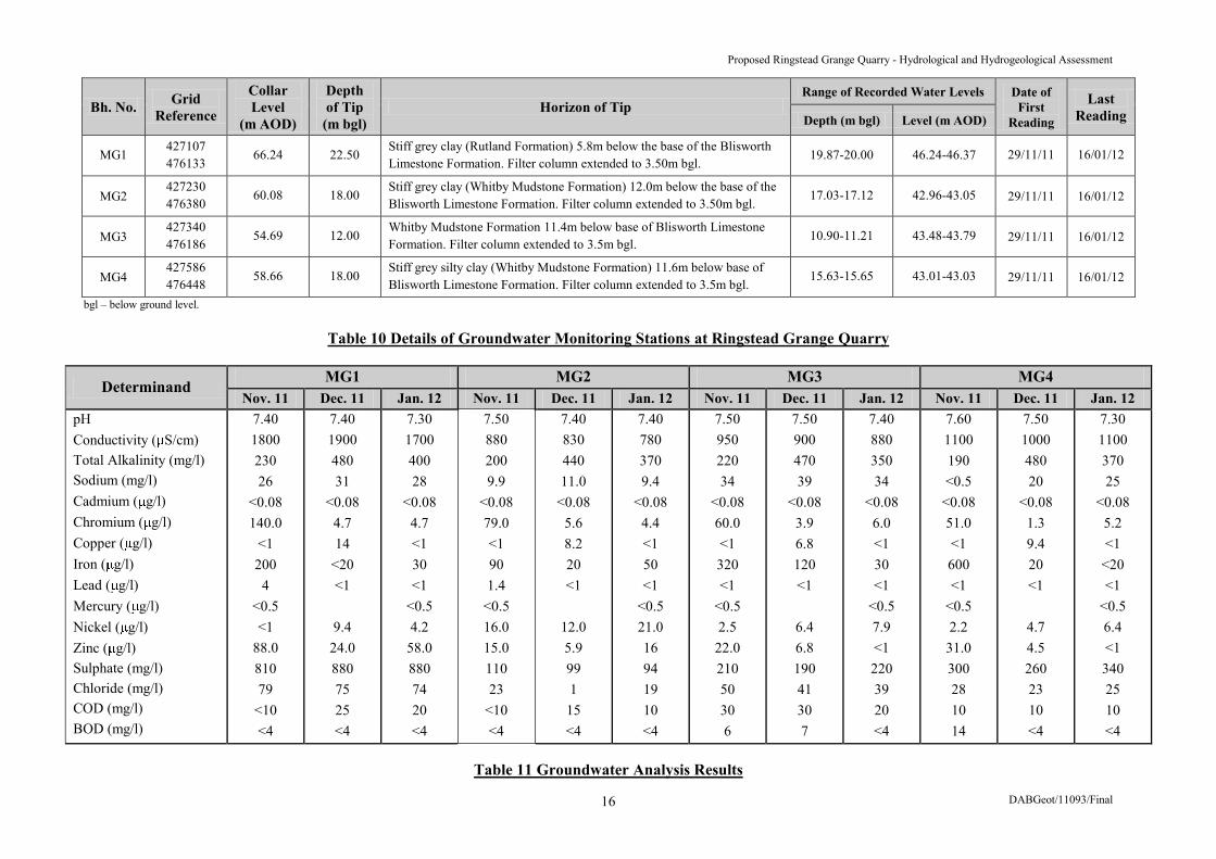
Proposed Ringstead Grange Quarry - Hydrological and Hydrogeological Assessment
DABGeot/11093/Final 16
Bh. No. Grid Reference
Collar Level
(m AOD)
Depth of Tip (m bgl)
Horizon of Tip Range of Recorded Water Levels Date of
First Reading
Last Reading Depth (m bgl) Level (m AOD)
MG1 427107 476133
66.24 22.50 Stiff grey clay (Rutland Formation) 5.8m below the base of the Blisworth Limestone Formation. Filter column extended to 3.50m bgl.
19.87-20.00 46.24-46.37 29/11/11 16/01/12
MG2 427230 476380
60.08 18.00 Stiff grey clay (Whitby Mudstone Formation) 12.0m below the base of the Blisworth Limestone Formation. Filter column extended to 3.50m bgl.
17.03-17.12 42.96-43.05 29/11/11 16/01/12
MG3 427340 476186
54.69 12.00 Whitby Mudstone Formation 11.4m below base of Blisworth Limestone Formation. Filter column extended to 3.5m bgl.
10.90-11.21 43.48-43.79 29/11/11 16/01/12
MG4 427586 476448
58.66 18.00 Stiff grey silty clay (Whitby Mudstone Formation) 11.6m below base of Blisworth Limestone Formation. Filter column extended to 3.5m bgl.
15.63-15.65 43.01-43.03 29/11/11 16/01/12
bgl – below ground level.
Table 10 Details of Groundwater Monitoring Stations at Ringstead Grange Quarry
Determinand MG1 MG2 MG3 MG4 Nov. 11 Dec. 11 Jan. 12 Nov. 11 Dec. 11 Jan. 12 Nov. 11 Dec. 11 Jan. 12 Nov. 11 Dec. 11 Jan. 12
pH Conductivity ( S/cm) Total Alkalinity (mg/l) Sodium (mg/l) Cadmium ( g/l) Chromium ( g/l) Copper ( g/l) Iron ( g/l) Lead ( g/l) Mercury ( g/l) Nickel ( g/l) Zinc ( g/l) Sulphate (mg/l) Chloride (mg/l) COD (mg/l) BOD (mg/l)
7.40 1800 230 26
<0.08 140.0
<1 200
4 <0.5 <1
88.0 810 79
<10 <4
7.40 1900 480 31
<0.08 4.7 14
<20 <1
9.4
24.0 880 75 25 <4
7.30 1700 400 28
<0.08 4.7 <1 30 <1
<0.5 4.2
58.0 880 74 20 <4
7.50 880 200 9.9
<0.08 79.0 <1 90 1.4
<0.5 16.0 15.0 110 23
<10 <4
7.40 830 440 11.0
<0.08 5.6 8.2 20 <1
12.0 5.9 99 1
15 <4
7.40 780 370 9.4
<0.08 4.4 <1 50 <1
<0.5 21.0 16 94 19 10 <4
7.50 950 220 34
<0.08 60.0 <1 320 <1
<0.5 2.5
22.0 210 50 30 6
7.50 900 470 39
<0.08 3.9 6.8 120 <1
6.4 6.8 190 41 30 7
7.40 880 350 34
<0.08 6.0 <1 30 <1
<0.5 7.9 <1 220 39 20 <4
7.60 1100 190 <0.5
<0.08 51.0 <1 600 <1
<0.5 2.2
31.0 300 28 10 14
7.50 1000 480 20
<0.08 1.3 9.4 20 <1
4.7 4.5 260 23 10 <4
7.30 1100 370 25
<0.08 5.2 <1
<20 <1
<0.5 6.4 <1 340 25 10 <4
Table 11 Groundwater Analysis Results

Proposed Ringstead Grange Quarry - Hydrological and Hydrogeological Assessment
DABGeot/11093/Final 17
All four monitoring installations are standpipes that record the groundwater conditions within the
succession extending above the Whitby Mudstone Formation. It can be deduced from the recorded levels that there is relatively little water present and that consequently inflow rates into the excavations will be very low.
4.4 Groundwater Quality
The Landmark Envirocheck report (Appendix A) does not provide any details of groundwater quality, but the Environment Agency’s website confirms that the current quantitative and chemical quality in the Northampton Sands and, ‘Lower Jurassic Unit’, is good at Grid Refs. 497213 273484 and 499118 272309. There are no recorded groundwater pollution incidents. Groundwater samples have been taken from the monitoring installations and the analysis results are presented in Table 11. The following observations can be made: (i) the pH levels reflect neutral conditions;
(ii) conductivity ranges from 780 to 1900 S/cm indicating low to moderate levels of solute
concentration; (iii) heavy metal concentrations are generally quite low, in particular the red list substances
cadmium and mercury; (iv) chloride concentrations are low; and (v) sulphate concentrations are variable and the majority exceed the drinking water standard. The analysis results represent the, ‘average’, chemical composition for the groundwater present in the bedrock succession. Some of the marine mudstones, such as those of the Whitby Mudstone Formation, contain iron pyrites which weather to form sulphate. Any localised acidity is adequately buffered by the dissolved calcium carbonate and bicarbonate derived from the limestones.
4.5 Licensed and Unlicensed Groundwater Abstractions
The Landmark Envirocheck report (Appendix A) indicates that there are four licensed groundwater abstractions within the search area, two of which have been revoked. The status of one of the remaining abstractions is not known, but both lie some distance from the site. A summary of the details is provided in Table 12.
East Northamptonshire Council has confirmed that there are no unlicensed (private) groundwater abstractions within at least 1km of the site boundary (Appendix B).

Proposed Ringstead Grange Quarry - Hydrological and Hydrogeological Assessment
DABGeot/11093/Final 18
Licence Holder (Reference No.)
Recorded Grid Ref.
Distance from Centre of Site (m)
Abstraction Source
Purpose of Abstraction (Permitted Maximum Rate)
Nene & Ouse Water Board, Cotton Lane, Raunds (5/32/09/*g/182) Status: Revoked
497800 272800 497400 272500
1,133 1,548 Well and borehole Public water supply
(750 m3/day; 2,045,700 m3 p.a.)
ARC Eastern, Gravel Pit, Ringstead (5/32/09/*g/193) Status: Revoked
497000 274500 1,208 Groundwater fed
reservoir Sand and gravel washing (1,200 m3/day; 4,191,500 m3 p.a.)
Tithe Farm, Ringstead (5/32/09/*g/0222) Status: Not Supplied
498140 275600 1,699 Borehole General farming and domestic
(Abstraction rates not supplied)
M. W. Holben Ham Lane, Ringstead (5/32/09/*g/196) Status: Perpetuity
498200 275600 1,703 Well and borehole Agriculture (general)
(13 m3/day; 36,370 m3 p.a.)
Table 12 Summary of Licensed Groundwater Abstractions 4.6 Waste Handling, Disposal and Treatment Sites and Waste Transfer Stations There are no registered or historic landfill sites, waste handling or treatment sites, or waste transfer
stations within the Landmark Envirocheck search area. The Environment Agency’s website provides details of a number of historic landfill sites, but the closest are located some 2 to 2.5km to the north and north-east of the proposed development.
Gas monitoring has been carried out on the site and the results are presented in Table 13. Very
little or no methane has been encountered in the absence of any putrescible material. The presence of carbon dioxide and the slight depletion of oxygen concentrations are thought to reflect anaerobic bacterial activity in the soils and weathered bedrock.
Borehole No. MG1 MG2 MG3 MG4
Parameter Nov. 2011
Dec. 2011
Jan. 2012
Nov. 2011
Dec. 2011
Jan. 2012
Nov. 2011
Dec. 2011
Jan. 2012
Nov. 2011
Dec. 2011
Jan. 2012
Weather Temperature (°C) Atmospheric Pressure (mb) Differential Pressure (mb) Methane (% v/v) Carbon dioxide (% v/v) Oxygen (% v/v)
OV 11.0 1000 0.05
0 2.5
18.7
OV 8.0
1002 -0.06
0 0.6
20.3
C 3.0
1025 0.06
0 0.4
20.3
OV 11.0 1000 0.18
0 1.3
20.5
OV 8.0
1002 0.11
0 1.8
19.8
C 3.0
1025 0.04
0 1.4
19.5
OV 11.0 1000 0.21 0.1 1.5
20.3
OV 8.0
1002 0.01
0 1.6
19.7
C 3.0
1025 0.03
0 1.9
19.1
OV 11.0 1000 0.13
0 1.4
20.6
OV 8.0
1002 -0.08
0 0.8
20.2
C 3.0
1025 0.05
0 2.4
18.3 OV – Overcast C - Clear
Table 13 Summary of Gas Monitoring Results
Proposed Ringstead Grange Quarry - Hydrological and Hydrogeological Assessment
DABGeot/11093/Final 19
5. PREDICTED EFFECTS OF PROPOSED QUARRY DEVELOPMENT AND
MITIGATION MEASURES 5.1 Management of Water on the Proposed Quarry Site
The development has been designed so that a large part of the site will remain undisturbed and in
agricultural production or in a state of restoration at any one time. It is proposed to manage surface runoff and groundwater using a system of cut-off ditches, drainage channels and temporary sumps. The water will be pumped and/or drained to treatment areas that will comprise settlement ponds with storm water storage capacity, some of which will be permanently established in the southern part of the site. Additional storage will be provided in the excavations and in the drainage channels. The treated water will be discharged into the unnamed tributary of Hog Dyke as shown on the Working Scheme Plan (Dwg. No. R15/03). An environmental permit (discharge consent) will be sought from the Environment Agency. The southern lagoons will form a permanent feature of the restored site. It is also proposed to drain water from the northern part of the site following its restoration to agricultural land. Wetland areas will be established to create additional retention with the aim of resolving the present problem of flooding on Station Road at the point shown on Figure 6.
5.2 Groundwater Resources 5.2.1 Estimated Groundwater Inflow Rates
The site will be developed in a progressive manner with the excavations formed along a succession of cuts. These are shown on the Working Scheme Plan (Dwg. No. R15/03) as Phases 1 to 23 and be backfilled as the limestone is extracted. The operator will aim to minimise the area of disturbed ground and hence the size of the excavation void at any one time. The borehole monitoring installations (Table 10) suggest that very little groundwater will be encountered in the quarry excavations. This will be largely confined within the Blisworth Limestone Formation, the base of which will form the quarry floor, but there is likely to be some leakiness owing the presence of natural joints and fissures. For the purposes of this exercise, it has been assumed that the saturated thickness is 2.20m, just under half that of the limestone. This is a conservative assumption and the formation may well prove to be largely dewatered. Groundwater inflow will extend from all four excavated slopes of the initial boxcut and subsequently from a combination of in situ bedrock and inert fill that will be placed in the exhausted workings. The backfill will comprise a mixture of overburden and imported material, some of which will be cohesive in nature.
Reference has been made to Science Report SC040020/SR1 (Environment Agency, 2007) to estimate the inflow rates. The lateral extent of the drawdown will vary dependent on the length of time that transpires as each excavation cut is formed and the rate of recovery where the workings have been backfilled. The Working Scheme Plan (Dwg. No. R15/03), which forms part of the planning submission, shows that the cut lengths will vary from about 295 to 530m. The initial boxcut in the north-eastern part of the site will measure some 382m in length and 100m in width. Thereafter, the majority of the excavation cuts are 50 to 60m wide.

Proposed Ringstead Grange Quarry - Hydrological and Hydrogeological Assessment
DABGeot/11093/Final 20
If it is assumed that the groundwater flow in the Blisworth Limestone is confined, the inflow rate per linear metre of excavation (Q) can be estimated using the Thiem equation for steady state conditions: Q = 2 KD(s1 – s2)/2.30log(r2/r1), where K is the hydraulic conductivity, D is the saturated thickness of the aquifer, s1 and s2 represent the drawdown in two observation boreholes and r2 and r1 are the distances or radii extending from an abstraction well. If there is only one observation point and the water is drawn from an excavation, the equation becomes:
Q = 2 D(se)/2.30log(Ro/re) where se is the drawdown in the excavation, re is the effective radius of the excavation and Ro is the radius of influence equivalent to the distance at which there is no drawdown (i.e. s2 is zero). The equivalent radius (re) can be estimated using the equation for a rectangular excavation provided by Powrie and Preene (1992): re = (a + b)/
There are independent methods of estimating the value of Ro. Sichardt’s equation has been used and whilst this grossly under-estimates its value it does give a conservative inflow rate from which adequate pumping capacity can be determined. The use of this equation is, however, not encouraged by the Environment Agency. Fortunately, the maximum value of Ro can be estimated at Ringstead Grange because the limestone outcrops beneath the soil and glacial cover in relatively close proximity (1/10,000 scale geological maps in Appendix D). The exploratory boreholes suggest that it lies even closer. Nevertheless, a range of Ro values has been used equivalent to re plus 50, 100, 200 and 300m. (Note. These are measured from the centre of the excavation as is re.) The drawdown (se) has been taken as 2.20m. The hydraulic conductivity of the limestone has been taken as 10-6 m/s to reflect the lithostatic unloading that will occur during the quarrying process and some measure of dissolution along the natural joints. The conductivity of the backfill will vary considerably. Initially, it could be as high as 10-3 m/s, but it will become less permeable as it is surcharged by additional volumes of material, probably falling to 10-5 m/s about one or two cut widths back from the excavation void. Backfilling will be progressive, but the calculations have been based on two cut widths for those excavations extended beyond the boxcut (i.e. Phase 1). An additional allowance has also been made for flow along the loosewall (a factor of ten times higher per linear metre). The calculation results are presented in Table 14. Faulting is known to be present on the site and although this might compartmentalise the groundwater, its effect has been ignored.

Proposed Ringstead Grange Quarry - Hydrological and Hydrogeological Assessment
DABGeot/11093/Final 21
The estimated inflow rates are low showing little change beyond a distance of about 400 to 500m from the centre of the excavations. Flow rates through the quarry floor will be insignificant. This will comprise mudstone strata of the Rutland Formation. Experience has shown that by far the majority of the water that will be drawn from the excavations will be surface runoff. This will serve to dilute the solute concentrations detailed in Table 11.
Dimensions length x width
(m) se (m) re (m) Ro (m) Notes
Estimated Inflow Rate from Bedrock
(l/s per linear m)
Total Inflow Rate (l/s)
BOXCUT (PHASE 1)
382 x 100 2.2 153
216 266 366 466
Inflow from bedrock on four sides. BGS mapped extent of limestone extends only 220m to the north-east of the excavations. Exploratory drilling
suggests that the outcrop lies closer.
0.09 x 10⁻³ 0.06 x 10⁻³ 0.03 x 10⁻³ 0.03 x 10⁻³
0.09 0.06 0.03 0.03
INTERMEDIATE EXCAVATION (PHASE 5)
358 x (50 x 2) 2.2 146
220 270 370 470
Inflow from bedrock on three sides, backfill on one side. BGS mapped extent of limestone extends only 220m to
north-east of the excavations. Exploratory drilling suggests that the outcrop lies closer.
0.07 x 10⁻³ 0.05 x 10⁻³ 0.03 x 10⁻³ 0.03 x 10⁻³
0.04 + 0.25 = 0.29 0.03 + 0.18 = 0.21 0.02 + 0.11 = 0.13 0.02 + 0.11 = 0.13
INTERMEDIATE EXCAVATION (PHASE 11)
354 x (48 x 2) 2.2 143
198 248 348 448
Inflow from bedrock on three sides, backfill on one side. BGS mapped extent of limestone extends only 220m to
north-east of the excavations. Exploratory drilling suggests that the outcrop lies closer.
0.09 x 10⁻³ 0.06 x 10⁻³ 0.03 x 10⁻³ 0.03 x 10⁻³
0.05 + 0.32 = 0.37 0.03 + 0.21 = 0.24 0.02 + 0.11 = 0.13 0.02 + 0.11 = 0.13
INTERMEDIATE EXCAVATION (PHASE 16)
528 x (58 x 2) 2.2 205
247 297 397 497
Inflow from bedrock on two sides, backfill on two sides. BGS mapped extent of limestone extends only 220m to
the south-east of the outer limit of excavations. Exploratory drilling suggests that the outcrop lies closer.
0.16 x 10⁻³ 0.08 x 10⁻³ 0.05 x 10⁻³ 0.03 x 10⁻³
0.10 + 1.03 = 1.13 0.05 + 0.51 = 0.56 0.03 + 0.32 = 0.35 0.02 + 0.19 = 0.21
Table 14 Estimated Groundwater Inflow Rates
5.2.2 Effect of Drawdown The calculation results shown in Table 14 are based on a saturated thickness of 2.20m in the Blisworth Limestone. This is a conservative assumption and it is thought that very little groundwater will be encountered. Any drawdown will be very restricted in lateral extent and will be further confined by the outcrop of the limestone. Table 12 provides details of two licensed groundwater abstractions that are presently active. Both lie at some considerable distance from the centre of the site where they are unlikely to be derogated by any drawdown in the Blisworth Limestone Formation or the overlying strata. There are no private or unlicensed abstractions within 1km of the site boundary (Appendix B).

Proposed Ringstead Grange Quarry - Hydrological and Hydrogeological Assessment
DABGeot/11093/Final 22
The groundwater monitoring installations point to the complete absence of high piezometric
pressures in the bedrock and it can be concluded that the topsoil and subsoil are subsoil are most likely under-drained in the Ringstead Grange area. Consequently, it is not thought that any drawdown in the Blisworth Limestone Formation will have an adverse effect on surface vegetation and agricultural yields. There will be no adverse effect on the abandoned sand and gravel workings that lie some distance to the north-west and south-west of the site. These have been identified as important areas of ecological interest (i.e. SSSI and Ramsar status).
5.2.3 Shrinkage of Bedrock Strata Concern has been expressed that the dewatering operations at the quarry will lead to shrinkage of
the mudstones that underlie Ringstead village and other buildings in the area. Shrinkage could damage the foundations and give rise to cracking and structural damage (BRE, 1990a, 1990b, 1993 and 1997; Bonshor and Bonshor, 1997). Some of the mudstones in the Jurassic strata do contain clays of montmorillonitic or mixed layer type and as such will swell and shrink with changes in moisture content. These changes can be brought about by the growth or removal of trees.
The mining and ground stability report in Appendix F indicates that the potential for swelling and
shrinkage around Ringstead village is low regardless of the very limited extent of any drawdown around the proposed quarry excavations. Any dewatering will only affect the Blisworth Limestone Formation and the overlying strata. For this reason, the nearest building structures at Ringstead Grange Farm will not be placed at risk. Top Lodge is unoccupied and derelict.
5.2.4 Settlement of Backfill The backfill materials will be tipped, spread and trafficked by the earthmoving plant deployed at
the quarry, but it is not planned to undertake systematic compaction. Self-weight compaction and consolidation will occur as the height of the fill is raised. There will be some creep settlement which can be expressed as follows:
Ds = αHlog10(t2/t1) Sowers et al. (1965)
where Ds is the vertical strain or settlement, α is the creep compression parameter and t1 and t2 are measured times after placement.
The creep compression parameter will probably equate to approximately 0.5% at the Ringstead
Grange site, within the range 0.2% for fully compacted rockfill to 1% for loose tipped mudstone. This will equate to a maximum of 0.06m in the period 1 to 10 years after placement where the fill reaches a maximum of 12m in thickness. The majority of the settlement will occur during and shortly after placement (i.e. during the operational period of the quarry). A further 0.06m may then occur within the period 10 to 100 years. The loose tipped material in the former ironstone workings to the north of the site shows very little evidence of settlement.
Proposed Ringstead Grange Quarry - Hydrological and Hydrogeological Assessment
DABGeot/11093/Final 23
Collapse settlement will also occur in the fill due to the infiltration of surface water and the
recovery of groundwater. The scale of this settlement will depend on the degree of compaction achieved during the placement of the fill, but is expected to be of the order of a few millimetres.
The restoration drainage system will be designed to cater for the likely settlement that will occur in
the fill. Particular attention will be paid to those areas where the differential settlement is likely to be greatest (e.g. buried excavation slopes). Provision will also be made to cater for the possible increased levels of rainfall that might occur as a consequence of climate change.
5.2.5 Groundwater Quality
There are no known waste handling or treatment sites, or waste transfer stations within at least 1km of the centre of the proposed site. These might otherwise represent potential sources of groundwater contamination. The analysis results presented in Table 11 give some impression as to the quality of the groundwater on the site. Owing to the nature of the monitoring installations, however, the sampled water may be partly or wholly derived from strata underlying the Blisworth Limestone Formation. The exhausted workings will be partly backfilled using overburden and discard materials from the crushing and screening process. This material will comprise a mixture of clay, mudstone and some limestone and as such will be pH neutral. It is not expected to have an adverse impact on groundwater quality. The proposed importation of inert material to complete the backfilling process will be subject to legislative control. This will also ensure that there is no adverse impact.
5.3 Surface Water Resources 5.3.1 Flood Risk A Flood Risk Assessment has been carried out in accordance with PPS25 (Department for
Communities and Local Government, 2010) and a copy is provided in Appendix G. The assessment has been set out in accordance with the proforma provided by the Department for Communities and Local Government (2009). The main conclusions of the assessment are summarized below. (i) The site lies in Flood Zone 1 and there will be negligible risk of flooding from streams or
rivers during the extraction, restoration and post-restoration phases. (ii) There will be only a very low risk of flooding of the excavations by groundwater. (iii) Surface runoff from the site will largely accumulate in the excavations. There is a risk that
during extreme weather conditions the rate of surface runoff will exceed the capacity of the drainage channels and any pumps that may be deployed. The excavations may then be partly inundated. This risk is fully accepted by the developer and will not have any impact outside the quarry.

Proposed Ringstead Grange Quarry - Hydrological and Hydrogeological Assessment
DABGeot/11093/Final 24
(iv) Discharges of treated water from the quarry will be controlled at or below greenfield rates
and consequently there will be no increased risk of downstream flooding.
(v) The land use and drainage of the restored site (Dwg. No. R15/04) are such that the long-term runoff characteristics can be maintained at not greater than greenfield rates. Additional attenuation will be provided by the creation of wetland areas in the north, western and southern parts of the site.
(vi) There are no proposals for flood defences or mitigation measures that might increase
flood risk elsewhere.
5.3.2 Attenuation Storage Volumes
The proposed quarry workings have been designed so as to minimize the area of disturbance at each stage of its development. The exhausted workings will be backfilled and restored to re-establish the present landform and greenfield runoff rates. The drainage water from the restored area will be directed into the excavations, but as it is extended, the flow paths will be extended to supply wetland areas along the northern perimeter and in the western part of the site. Some of the water will be discharged at point D1 into a new drainage channel that will be extended to Station Road. This will alleviate the localized flooding problem shown on Figure 6 (see Section 5.3.3). The discharges will represent normal agricultural drainage only. Surface runoff and groundwater that flows or is pumped from the working areas will be directed through water treatment areas and will be discharged, subject to the consent of the Environment Agency, into the unnamed tributary of Hog Dyke along the south-eastern perimeter of the site. The volume of storage required to attenuate the discharge of water from the disturbed areas of the site has been determined using a lumped input-storage-output model as described in the CIRIA SUDS Manual (CIRIA, 2007). The site lies in two catchment areas (Figure 5) and the highest rainfall intensities derived using the Flood Estimation Handbook CD-ROM were used in the calculations. Storm durations of up to 380 hours were considered with return periods of 1, 10, 20, 30, 50, 100 and 200 years. The area of disturbance was determined for each stage of the development shown on the Indicative Phasing Plans (Dwg. No. R15/05), together with an estimate of that created during the formation of the boxcut (Phase 1). A factor of 0.85 has been applied to all areas of bare earth, including newly constructed soil storage mounds, to calculate the equivalent impermeable area. This may well prove to be a conservative estimate as the infiltration could well be much greater, especially where unsaturated bedrock strata are exposed. The restored boxcut area was assumed to have the same runoff characteristics as the existing arable land and a factor of 0.35 was applied based on the catchment characteristics given in Table 3. Details of the calculations are provided in Table 15.

Proposed Ringstead Grange Quarry - Hydrological and Hydrogeological Assessment
DABGeot/11093/Final 25
The minimum area of disturbance at any stage during the quarry development will be 13.5 hectares. The water from this area will be drained and treated and then discharged to the south of the quarry at a greenfield rate of 2.4 x 13.5 = 32 l/s (i.e. QBAR x area). This will be the discharge flow rate into the unnamed tributary of Hog Dyke for which consent will be sought from the Environment Agency. It will apply for the entire duration of the quarry development and for all storm events.
Development Stage Disturbed Areas
Total Area (ha)
Equivalent Impermeable
Area (ha)
Boxcut (Phase 1)
Access road, site service area, excavation and soil strip area; soil storage areas, topsoil storage mounds T1, T2 and T3, subsoil mounds S1 and S2 (all prior to development of grass cover); access tracks to soil strip areas.
13.5 11.5
Around Phase 5 Access road, site service area, excavation and soil strip area; soil storage mound S3 (prior to grass cover) and restored boxcut area (4.7 ha).
15.6 10.9
Around Phase 11 Access road, site service area, excavation and soil strip area.
13.5 11.5
Around Phase 16 Access road, site service area, excavation and soil strip area.
15.0 12.8
Table 15 Estimated Areas of Disturbance and Equivalent Impermeable Areas
A conservative estimate of the groundwater inflow is provided in Table 14. The volume of groundwater was determined for the lumped input-storage-output model using the inflow rate for Ro = re + 50m (i.e. the highest value) for each of the development stages considered. The rainfall values were also increased by a factor of 10% to account for the likely effects of climate change and in accordance with the recommendations made in PPS25 Table B2. This assumes that the development will commence in 2012 or 2013. It is expected that greenfield runoff rate will also increase, but a corrected value has not been used in the calculations. The spreadsheet calculations are presented in Appendix H and a summary is given in Table 16.
Development Stage
Attenuation Storage Required (m3) (based on QBAR for all events)
1 in 1 year 1 in 30 year 1 in 100 year
Boxcut (Phase 1) Around Phase 5 Around Phase 11 Around Phase 16
903 825 909
1,106
6,810 6,391 6,822 7,780
9,690 9,121 9,702
11,021
Table 16 Summary of Estimated Attenuation Storage Volumes
(Based on a discharge flow of QBAR for all events)

Proposed Ringstead Grange Quarry - Hydrological and Hydrogeological Assessment
DABGeot/11093/Final 26
By far the majority of the required storage will be provided in the quarry excavations, but capacity
will also be created in the areas that have been stripped of soils as these will be bounded by shallow excavation slopes. There will be significant retention in the water treatment lagoons and drainage channels. Partial flooding of the mineral workings during times of inclement weather is relatively commonplace and the risk is fully accepted by the developer.
5.3.3 Flooding of Station Road It has been reported that Station Road occasionally floods at a point adjacent to the cemetery as
shown on Figure 6. It would appear that the drainage channel that extends along the south-western perimeter of the cemetery presently discharges directly onto the road because of blockages in the roadside ditch. An attempt has been made to attenuate the discharge flow by constructing two storage lagoons at the location shown on Figure 6 (Photograph P6), one of which is unlined and does not appear to retain water. It is proposed to divert the majority of the surface flow from the application site by creating a wetland area in its northern part and diverting the water along a more westerly route. This will then flow through the 150mm diameter drain that extends beneath Station Road and into the lake that lies beyond. The drain will require further inspection and remedial work.
5.3.4 Surface Water Abstractions There are no licensed or unlicensed surface water abstractions within at least 1km of the site. The
proposed excavations also lie some distance from the River Nene, Hog Dyke and the flooded mineral workings that now form protected areas. There will be changes in the pattern of surface flow during the development, but the supply of water will be compensated by discharges into the unnamed tributary of Hog Dyke along the south-eastern perimeter of the site.
5.3.5 Surface Water Quality The discharge of treated water from the site will require the consent of the Environment Agency in
the form of an environmental permit. The Agency will not only determine the discharge flow rate to ensure that there will be no increased risk of downstream flooding, but also the quality of the water. This will ensure that there will be no adverse effect on the nature conservation sites into which Hog Dyke and its tributaries flow.
It is anticipated that the principal contaminant in the untreated water will be suspended solids and
that this can be suitably remediated by simple settlement. The majority will be retained in temporary sumps formed within the excavations. The water treatment facilities will be regularly inspected in accordance with the Quarries Regulations (1999). This will ensure that immediate action is taken to maintain their stability, security and efficient operation. If it is required to use flocculants, their use and dosage rate will be first agreed with the Agency. The operator will have in place emergency measures to deal with any spillages (e.g. the deployment of absorbent mats and booms). Fuel oil storage areas will be adequately bunded in accordance with Control of Pollution (Oil Storage) (England) Regulations 2001 to protect both surface and groundwater.

Proposed Ringstead Grange Quarry - Hydrological and Hydrogeological Assessment
DABGeot/11093/Final 27
6. SUMMARY 6.1 Mick George Ltd. proposes to develop a limestone quarry on land at Ringstead Grange Farm. The
exhausted workings will be backfilled with overburden, quarry discard and imported inert fill materials, subject to the approval of the Environment Agency. The excavations will extend in depth to a maximum of about 12m below ground level.
6.2 The proposed development will not have an adverse effect on surface water resources. There are
no licensed or unlicensed surface water abstractions within at least 1km of the site. Consent will be sought from the Environment Agency to discharge treated water from the quarry during its operation. It will determine the quality of the water and this will ensure that there is no adverse impact on the receiving watercourses. It can therefore be concluded that there will be no adverse effect on the areas of nature conservation in the Nene valley. The flows will be maintained at or below greenfield rates and consequently there will be no increased risk of downstream flooding. Storm flows will be attenuated by providing adequate storage during the operation of the site, principally within the excavations. Partial flooding of the excavations during periods of prolonged inclement weather is relatively commonplace in the quarrying industry and is fully accepted by the operator.
6.3 The existing landform will be largely replicated as part of the proposed restoration scheme with
the majority taking the form of agricultural land. Wetland areas will be created to attenuate surface flow. The northern part of the site will be drained towards the north, as is presently the case, using the existing or a newly created agricultural drainage system. Greenfield runoff rates will be restored throughout the site.
6.4 There will be no adverse impact on groundwater resources. There are no licensed or unlicensed
groundwater abstractions within at least 1km of the site. It is expected that very little groundwater will be encountered in the excavations and consequently any drawdown will be very limited in extent. The effect of any drawdown will be limited in area underlain by the Blisworth Limestone Formation. By far the majority of the water that will be drawn from the quarry workings will be surface runoff. The development will not increase the potential for swelling and shrinkage of the clays and mudstones underlying Ringstead village or any other buildings around the site. The farmstead at Top Lodge is unoccupied and derelict.
6.5 There are no known waste handling or treatment sites, or waste transfer stations within at least
1km of the proposed quarry that might otherwise represent potential sources of groundwater contamination. The mineral excavations will be backfilled with material that will not have an adverse impact on groundwater quality. The restoration drainage scheme will be designed to cater for the settlement that will occur in the fill and the likely effects of climate change.

Proposed Ringstead Grange Quarry - Hydrological and Hydrogeological Assessment
DABGeot/11093/Final 28
7. REFERENCES
Allen, D. J., Brewerton, L. J., Coleby, L. M., Gibbs, B. R., Lewis, M. A., MacDonald, A. M., Wagstaff, S. J. and Williams, A. T. (1997), ‘The Physical Properties of Major Aquifers in England and Wales’. British Geological Survey Technical Report WD/97/34. Environment Agency R & D Publication 8. Keyworth, Nottingham. 312p. Barron, A. J. M., Morigi, A. N. and Reeves, H. J. (2006), ‘Geology of the Wellingborough District’. British Geological Survey, Keyworth, Nottingham. 34p. Boorman, D. B., Hollis, J. M. and Lilly, A. (1995), ‘Hydrology of Soil Types: a Hydrology of Soil Types: a Hydrologically Based Classification of the Soils of the United Kingdom’. IoH Report No. 126. Institute of Hydrology, Wallingford. Bonshor, R. B. and Bonshor, L. L. (1997), ‘Cracking in Buildings’. Building Research Establishment. Construction Research Communications Ltd. 102p. Watford. Building Research Establishment (1990a), ‘Digest 240: Low Rise Buildings on Shrinkable Clay Soils’. Part 2. 4p. Watford. Building Research Establishment (1990b), ‘Digest 361: Cracking in Buildings’. 4p. Watford. Building Research Establishment (1993), ‘Digest 240: Low Rise Buildings on Shrinkable Clay Soils’. Part 1. 4p. Watford. Building Research Establishment (1997), ‘Digest 412: Desiccation in Clay Soils’. Part 1. 10p. Watford.
CIRIA (2007), ‘The SUDS Manual’. Report C697. CIRIA, London. Department for Communities and Local Government (2010), ‘Planning Policy Statement 25: Development and Flood Risk’. Revised edition, March. HMSO, London.
Department for Communities and Local Government (2009), ‘Planning Policy Statement 25: Development and Flood Risk Practice Guide’. December. 181p. London. Department of the Environment, Fisheries and Rural Affairs (2003), Supplementary Note on Climate Change - Considerations for Flood and Coastal Management. Flood Management Division/Environment Agency. April 2003.
Environment Agency (2004), ‘National Standing Advice to Local Planning Authorities for Planning Applications’. Development and Flood Risk, England. User Guidance Note, June 2004.

Proposed Ringstead Grange Quarry - Hydrological and Hydrogeological Assessment
DABGeot/11093/Final 29
Environment Agency (2009), ‘River Nene Catchment Flood Management Plan’. December 2009. Faber Maunsell/AECOM (2006), ‘East Northamptonshire Council Strategic Flood Risk Assessment - Stage 2’. Report to East Northamptonshire Council. 104p plus Figures and Appendices. Health and Safety Executive (1999), ‘Quarries Regulations and Approved Code of Practice’. HMSO, London. Lancaster, J. W., Preene, M. and Marshall, C. T. (2004), ‘Development and Flood Risk – Guidance for the Construction Industry’. CIRIA Report C624. London. Natural Environment Research Council (1994), ‘Flood Estimation for Small Catchments’. Institute of Hydrology Report No. 124. Institute of Hydrology, Wallingford.
Natural Environment Research Council (1999), ‘Flood Estimation Handbook, with WIN-FAP FEH Software and FEH CD-ROM for Catchment Descriptors’. Centre for Ecology and Hydrology, Wallingford.
Powrie, W. and Preene, M. (1992), ‘Equivalent Well Analysis of Construction Dewatering Systems’. Geotechnique, 42, No. 4, pp 635-639 URS Scott Wilson (2011), ‘East Northamptonshire Council. Level 1. Strategic Flood Risk Assessment. Review and Update’. Report to East Northamptonshire Council August. 44p plus Appendices.

Proposed Ringstead Grange Quarry - Hydrological and Hydrogeological Assessment
DABGeot/11093/Final
FIGURES
Proposed Ringstead Grange Quarry - Hydrological and Hydrogeological Assessment
DABGeot/11093/Final
Reproduced with the Permission of Controller of H. M. Stationery Office © Crown Copyright. All rights reserved. Licence No. WL1005542 DAB Geotechnics.
Figure 1 Site Location (based on 1/50,000 scale OS map)
DAB Geotechnics Proposed Ringstead Grange Quarry Date: December 2011
1km
1km
Proposed Ringstead Grange Quarry - Hydrological and Hydrogeological Assessment
DABGeot/11093/Final
Figure 2 Aerial Photograph
DAB Geotechnics Proposed Ringstead Grange Quarry Date: December 2011
New Zealand Farm 62

Proposed Ringstead Grange Quarry - Hydrological and Hydrogeological Assessment
DABGeot/11093/Final
Reproduced with the Permission of Controller of H. M. Stationery Office © Crown Copyright. All rights reserved. Licence No. WL1005542 DAB Geotechnics.
Figure 3 BGS GeoRecords Borehole Location Plan
DAB Geotechnics Proposed Ringstead Grange Quarry Date: December 2011

Proposed Ringstead Grange Quarry - Hydrological and Hydrogeological Assessment
DABGeot/11093/Final
Reproduced with the Permission of Controller of H. M. Stationery Office © Crown Copyright. All rights reserved. Licence No. WL1005542 DAB Geotechnics.
Figure 4 Exploratory Borehole Plan
DAB Geotechnics Proposed Ringstead Grange Quarry Date: December 2011
MG3
MG1
MG2
MG4
MG1 Mick George Ltd. Boreholes
ARC 2
ARC 4
ARC 3
ARC 1
ARC 7
ARC 6
ARC 8
ARC 5
ARC 8 ARC Borehole
MG5 MG9
MG8
MG7
MG6
MG5
groundwater monitoring installation

Proposed Ringstead Grange Quarry - Hydrological and Hydrogeological Assessment
DABGeot/11093/Final
Figure 5 Catchment Boundaries (as determined using FEH CD-ROM (NERC, 1999))
DAB Geotechnics Proposed Ringstead Grange Quarry Date: December 2011
Catchment Area 1
Catchment Area 2
Site Boundary

Proposed Ringstead Grange Quarry - Hydrological and Hydrogeological Assessment
DABGeot/11093/Final
PHOTOGRAPHS

Proposed Ringstead Grange Quarry - Hydrological and Hydrogeological Assessment
DABGeot/11093/Final
Photograph P1. Northern perimeter of tree filled gully along the south-eastern boundary of the site. An unnamed tributary of Hog Dyke flows along the gully which adjoins the A45 public road (08/12/11).
Photograph P2. Details of ditch that extends beneath the wooden fence and into the tree filled gully shown in Photograph P1 (08/12/11).
DAB Geotechnics Proposed Ringstead Grange Quarry Date: December 2011
Proposed Ringstead Grange Quarry - Hydrological and Hydrogeological Assessment
DABGeot/11093/Final
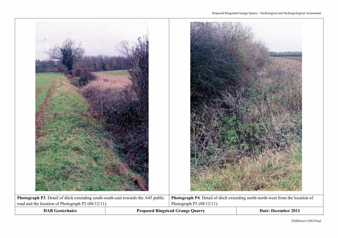
Photograph P3. Detail of ditch extending south-south-east towards the A45 public road and the location of Photograph P2 (08/12/11).
Photograph P4. Detail of ditch extending north-north-west from the location of Photograph P3 (08/12/11).
DAB Geotechnics Proposed Ringstead Grange Quarry Date: December 2011

Proposed Ringstead Grange Quarry - Hydrological and Hydrogeological Assessment
DABGeot/11093/Final
Photograph P5. Detail of ditch extending south-south-east from the northern boundary of the site (08/12/11).
Photograph P6. Detail of lined attenuation pond to the north of the site. The second unlined pond lies beyond (08/12/11).
DAB Geotechnics Proposed Ringstead Grange Quarry Date: December 2011

Proposed Ringstead Grange Quarry - Hydrological and Hydrogeological Assessment
DABGeot/11093/Final
APPENDIX A Landmark Envirocheck Report

Order Number: 37137693_1_1 Date: 04-Jan-2012 rpr_ec_datasheet v47.0 A Landmark Information Group Service
Datasheet
Order Details:Order Number:
Customer Reference:
National Grid Reference:
Slice:
Site Area (Ha):
Search Buffer (m):
Site Details:
Client Details:
37137693_1_1
11093
498050, 273900
A
0.01
1000
Site at 498050, 273900
Dr D BlytheDAB Geotechnics3, Tweed AvenueEllingtonMORPETHNorthumberlandNE61 5ES
Report:®Envirocheck

Order Number: 37137693_1_1 Date: 04-Jan-2012 rpr_ec_datasheet v47.0 A Landmark Information Group Service
Summary
Agency & Hydrological
Waste
Hazardous Substances
Geological
Industrial Land Use
Sensitive Land Use
Data Currency
Data Suppliers
Useful Contacts
Introduction
Copyright Notice
Natural England Copyright Notice
Ove Arup Copyright Notice
Peter Brett Associates Copyright Notice
Radon Potential dataset Copyright Notice
The Environment Act 1995 has made site sensitivity a key issue, as the legislation pays as much attention to the pathways by whichcontamination could spread, and to the vulnerable targets of contamination, as it does the potential sources of contamination. For this reason, Landmark's Site Sensitivity maps and Datasheet(s) place great emphasis on statutory data provided by the EnvironmentAgency and the Scottish Environment Protection Agency; it also incorporates data from Natural England (and the Scottish and Welshequivalents) and Local Authorities; and highlights hydrogeological features required by environmental and geotechnical consultants. It does notinclude any information concerning past uses of land. The datasheet is produced by querying the Landmark database to a distance defined bythe client from a site boundary provided by the client.
In the attached datasheet the National Grid References (NGRs) are rounded to the nearest 10m in accordance with Landmark's agreementswith a number of Data Suppliers.
© Landmark Information Group Limited 2012. The Copyright on the information and data and its format as contained in this Envirocheck®Report ("Report") is the property of Landmark Information Group Limited ("Landmark") and several other Data Providers, including (but notlimited to) Ordnance Survey, British Geological Survey, the Environment Agency and Natural England, and must not be reproduced in whole orin part by photocopying or any other method. The Report is supplied under Landmark's Terms and Conditions accepted by the Customer. A copy of Landmark's Terms and Conditions can be found with the Index Map for this report. Additional copies of the Report may be obtainedfrom Landmark, subject to Landmark's charges in force from time to time. The Copyright, design rights and any other intellectual rights shallremain the exclusive property of Landmark and /or other Data providers, whose Copyright material has been included in this Report.
Site of Special Scientific Interest, National Nature Reserve, Ramsar, Special Protection Area, Special Conservation Area, Marine NatureReserve data (derived from Ordnance Survey 1:10000 raster) is provided by, and used with the permission of, Natural England who retain thecopyright and Intellectual Property Rights for the data.
The Data provided in this report was obtained on Licence from Ove Arup & Partners Limited (for further information, [email protected]). No reproduction or further use of such Data is to be made without the prior written consent of Ove Arup & PartnersLimited. The information and data supplied in the product are derived from publicly available records and other third party sources and neitherOve Arup & Partners nor Landmark warrant the accuracy or completeness of such information or data.
The cavity data presented has been extracted from the PBA enhanced version of the original DEFRA national cavity databases. PBA/DEFRAretain the copyright & intellectual property rights in the data. Whilst all reasonable efforts are made to check that the information contained inthe cavity databases is accurate we do not warrant that the data is complete or error free. The information is based upon our own researchesand those collated from a number of external sources and is continually being augmented and updated by PBA. In no event shall PBA/DEFRAor Landmark be liable for any loss or damage including, without limitation, indirect or consequential loss or damage arising from the use of thisdata.
Information supplied from a joint dataset compiled by The British Geological Survey and the Health Protection Agency.
Report Section Page Number
Contents
Report Version v47.0
-
1
6
-
7
-
9
10
16
17

Order Number: 37137693_1_1 Date: 04-Jan-2012 rpr_ec_datasheet v47.0 A Landmark Information Group Service
Summary
Data Type PageNumber On Site 0 to 250m 251 to 500m
Agency & Hydrological
Waste
501 to 1000m
Contaminated Land Register Entries and Notices
Discharge Consents
Enforcement and Prohibition Notices
Integrated Pollution Controls
Integrated Pollution Prevention And Control
Local Authority Integrated Pollution Prevention And Control
Local Authority Pollution Prevention and Controls
Local Authority Pollution Prevention and Control Enforcements
Nearest Surface Water Feature
Pollution Incidents to Controlled Waters
Prosecutions Relating to Authorised Processes
Prosecutions Relating to Controlled Waters
Registered Radioactive Substances
River Quality
River Quality Biology Sampling Points
River Quality Chemistry Sampling Points
Substantiated Pollution Incident Register
Water Abstractions
Water Industry Act Referrals
Groundwater Vulnerability
Bedrock Aquifer Designations
Superficial Aquifer Designations
Source Protection Zones
Extreme Flooding from Rivers or Sea without Defences
Flooding from Rivers or Sea without Defences
Areas Benefiting from Flood Defences
Flood Water Storage Areas
Flood Defences
BGS Recorded Landfill Sites
Historical Landfill Sites
Integrated Pollution Control Registered Waste Sites
Licensed Waste Management Facilities (Landfill Boundaries)
Licensed Waste Management Facilities (Locations)
Local Authority Recorded Landfill Sites
Registered Landfill Sites
Registered Waste Transfer Sites
Registered Waste Treatment or Disposal Sites
Yes
Yes
n/a
n/a
n/a
n/a
n/a
n/a
n/a
n/a
n/a
n/a
n/a
3
Yes
1
2
n/a
n/a
n/a
n/a
n/a
n/a
n/a
n/a
(*12)
(*up to 2000m)
pg 1
pg 1
pg 1
pg 1
pg 2
pg 4
pg 5
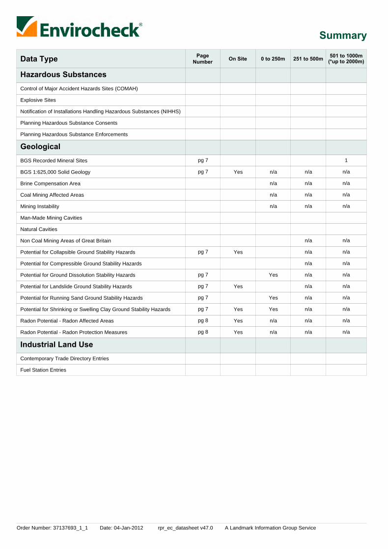
Order Number: 37137693_1_1 Date: 04-Jan-2012 rpr_ec_datasheet v47.0 A Landmark Information Group Service
Summary
Data Type PageNumber On Site 0 to 250m 251 to 500m
Hazardous Substances
Geological
Industrial Land Use
501 to 1000m
Control of Major Accident Hazards Sites (COMAH)
Explosive Sites
Notification of Installations Handling Hazardous Substances (NIHHS)
Planning Hazardous Substance Consents
Planning Hazardous Substance Enforcements
BGS Recorded Mineral Sites
BGS 1:625,000 Solid Geology
Brine Compensation Area
Coal Mining Affected Areas
Mining Instability
Man-Made Mining Cavities
Natural Cavities
Non Coal Mining Areas of Great Britain
Potential for Collapsible Ground Stability Hazards
Potential for Compressible Ground Stability Hazards
Potential for Ground Dissolution Stability Hazards
Potential for Landslide Ground Stability Hazards
Potential for Running Sand Ground Stability Hazards
Potential for Shrinking or Swelling Clay Ground Stability Hazards
Radon Potential - Radon Affected Areas
Radon Potential - Radon Protection Measures
Contemporary Trade Directory Entries
Fuel Station Entries
Yes
Yes
Yes
Yes
Yes
Yes
n/a
n/a
n/a
n/a
Yes
Yes
Yes
n/a
n/a
n/a
n/a
n/a
n/a
n/a
n/a
n/a
n/a
n/a
n/a
n/a
n/a
n/a
1
n/a
n/a
n/a
n/a
n/a
n/a
n/a
n/a
n/a
n/a
n/a
n/a
n/a
(*up to 2000m)
pg 7
pg 7
pg 7
pg 7
pg 7
pg 7
pg 7
pg 8
pg 8

Order Number: 37137693_1_1 Date: 04-Jan-2012 rpr_ec_datasheet v47.0 A Landmark Information Group Service
Summary
Data Type PageNumber On Site 0 to 250m 251 to 500m
Sensitive Land Use
501 to 1000m
Areas of Adopted Green Belt
Areas of Unadopted Green Belt
Areas of Outstanding Natural Beauty
Environmentally Sensitive Areas
Forest Parks
Local Nature Reserves
Marine Nature Reserves
National Nature Reserves
National Parks
Nitrate Sensitive Areas
Nitrate Vulnerable Zones
Ramsar Sites
Sites of Special Scientific Interest
Special Areas of Conservation
Special Protection Areas
1
1
1
1
1
(*up to 2000m)
pg 9
pg 9
pg 9
pg 9
pg 9

Order Number: 37137693_1_1 Date: 04-Jan-2012 rpr_ec_datasheet v47.0 A Landmark Information Group Service Page 1 of 17
Agency & Hydrological
MapID Details
QuadrantReference(CompassDirection)
EstimatedDistanceFrom Site
Contact NGR
1
2
3
4
Discharge Consents
Discharge Consents
Discharge Consents
Nearest Surface Water Feature
Pollution Incidents to Controlled Waters
River Quality
A9NW(SE)
A17SE(NW)
A14NE(E)
A8NE(SE)
A7NE(SW)
A9NW(SE)
655
882
955
512
766
599
1
1
1
-
1
1
Operator:Property Type:Location:Authority:Catchment Area:Reference:Permit Version:Effective Date:Issued Date:Revocation Date:Discharge Type:DischargeEnvironment:Receiving Water:Status:Positional Accuracy:
Operator:Property Type:Location:Authority:Catchment Area:Reference:Permit Version:Effective Date:Issued Date:Revocation Date:Discharge Type:DischargeEnvironment:Receiving Water:Status:Positional Accuracy:
Operator:Property Type:Location:Authority:Catchment Area:Reference:Permit Version:Effective Date:Issued Date:Revocation Date:Discharge Type:DischargeEnvironment:Receiving Water:Status:Positional Accuracy:
Property Type:Location:Authority:Pollutant:Note:Incident Date:Incident Reference:Catchment Area:Receiving Water:Cause of Incident:Incident Severity:Positional Accuracy:
Name:GQA Grade:Reach:Estimated Distance(km):Flow Rate:Flow Type:Year:
Kier Warth LtdSewage Disposal Works - OtherWarth Park London Rd, Raunds, NorthamptonEnvironment Agency, Anglian RegionMid River Nene (Oundle)Prnnf12044127th March 199727th March 1997Not SuppliedSewage Discharges - Final/Treated Effluent - Not Water CompanyFreshwater Stream/River
Roadside Ditch Tributary Hog DPost National Rivers Authority Legislation where issue date > 31/08/1989Located by supplier to within 100m
Mr H FosterSewage Disposal Works - OtherCotton Farm, Ringstead, KetteringEnvironment Agency, Anglian RegionNot SuppliedPr5nf218412nd January 19002nd January 190010th June 1991UnknownNot Supplied
Not SuppliedPre National Rivers Authority Legislation where issue date < 01/09/1989Located by supplier to within 100m
Evans & SonSewage Disposal Works - OtherWooton Green Farm, Wooton, Beds, Mk43 9efEnvironment Agency, Anglian RegionNot SuppliedPr1nfg045811st June 19631st June 196315th November 1991Discharge Of Other Matter-Surface WaterFreshwater Stream/River
Wooton BrookPre National Rivers Authority Legislation where issue date < 01/09/1989Approximate location provided by supplier
Not GivenKettering DistrictEnvironment Agency, Anglian RegionUnknownRaunds Hog Dyke13th August 19921442Not GivenFreshwater Stream/RiverUnknownCategory 2 - Significant IncidentLocated by supplier to within 100m
Hog DykeRiver Quality CHeadwaters...Sp 974 7305
Flow less than 0.31 cumecsRiver2000
498600273550
497400274500
499000274000
498386273518
497400273500
498441273450

Order Number: 37137693_1_1 Date: 04-Jan-2012 rpr_ec_datasheet v47.0 A Landmark Information Group Service Page 2 of 17
Agency & Hydrological
MapID Details
QuadrantReference(CompassDirection)
EstimatedDistanceFrom Site
Contact NGR
River Quality
Water Abstractions
Water Abstractions
Water Abstractions
Water Abstractions
A7NW(SW)
A3NW(S)
A3NW(S)
A16SE(NW)
A3NW(S)
936
1133
1154
1208
1214
1
1
1
1
1
Name:GQA Grade:Reach:Estimated Distance(km):Flow Rate:Flow Type:Year:
Operator:Licence Number:Permit Version:Location:Authority:Abstraction:Abstraction Type:Source:Daily Rate (m3):Yearly Rate (m3):Details:Authorised Start:Authorised End:Permit Start Date:Permit End Date:Positional Accuracy:
Operator:Licence Number:Permit Version:Location:Authority:Abstraction:Abstraction Type:Source:Daily Rate (m3):Yearly Rate (m3):Details:Authorised Start:Authorised End:Permit Start Date:Permit End Date:Positional Accuracy:
Operator:Licence Number:Permit Version:Location:Authority:Abstraction:Abstraction Type:Source:Daily Rate (m3):Yearly Rate (m3):Details:Authorised Start:Authorised End:Permit Start Date:Permit End Date:Positional Accuracy:
Operator:Licence Number:Permit Version:Location:Authority:Abstraction:Abstraction Type:Source:Daily Rate (m3):Yearly Rate (m3):Details:Authorised Start:Authorised End:Permit Start Date:Permit End Date:Positional Accuracy:
Hog DykeRiver Quality DSp 974 730...Nene1
Flow less than 0.31 cumecsRiver2000
Nene & Ouse Water Board5/32/09/*g/182 Not SuppliedWell, Cotton Lane, RAUNDSEnvironment Agency, Anglian RegionPublic Water SupplyNot SuppliedWell And Borehole7502045700Fluvial Sand and Gravel; Status: RevokedNot SuppliedNot SuppliedNot SuppliedNot SuppliedLocated by supplier to within 10m
Messrs D & E Tomaschuk5/32/09/*s/018 Not SuppliedHog Dyke At, RAUNDSEnvironment Agency, Anglian RegionSpray IrrigationNot SuppliedStream5120000Status: RevokedNot SuppliedNot SuppliedNot SuppliedNot SuppliedLocated by supplier to within 10m
A R C Eastern5/32/09/*g/193 Not SuppliedGravel Pit, RINGSTEADEnvironment Agency, Anglian RegionSand And Gravel WashingNot SuppliedGroundwater Fed Reservoir12004191500Fluvial Sand and Gravel; Status: RevokedNot SuppliedNot SuppliedNot SuppliedNot SuppliedLocated by supplier to within 10m
F R W Farrington5/32/09/*s/100 Not SuppliedStream At Groug Farm, RAUNDSEnvironment Agency, Anglian RegionSpray IrrigationNot SuppliedStream5681900Status: RevokedNot SuppliedNot SuppliedNot SuppliedNot SuppliedLocated by supplier to within 10m
497234273448
497800272800
497750272790
497000274500
497900272700

Order Number: 37137693_1_1 Date: 04-Jan-2012 rpr_ec_datasheet v47.0 A Landmark Information Group Service Page 3 of 17
Agency & Hydrological
MapID Details
QuadrantReference(CompassDirection)
EstimatedDistanceFrom Site
Contact NGR
Water Abstractions
Water Abstractions
Water Abstractions
Water Abstractions
A3SW(S)
A22SW(NW)
A2SE(SW)
A16NE(NW)
1430
1528
1548
1568
1
1
1
1
Operator:Licence Number:Permit Version:Location:Authority:Abstraction:Abstraction Type:Source:Daily Rate (m3):Yearly Rate (m3):Details:Authorised Start:Authorised End:Permit Start Date:Permit End Date:Positional Accuracy:
Operator:Licence Number:Permit Version:Location:Authority:Abstraction:Abstraction Type:Source:Daily Rate (m3):Yearly Rate (m3):Details:Authorised Start:Authorised End:Permit Start Date:Permit End Date:Positional Accuracy:
Operator:Licence Number:Permit Version:Location:Authority:Abstraction:Abstraction Type:Source:Daily Rate (m3):Yearly Rate (m3):Details:Authorised Start:Authorised End:Permit Start Date:Permit End Date:Positional Accuracy:
Operator:Licence Number:Permit Version:Location:Authority:Abstraction:Abstraction Type:Source:Daily Rate (m3):Yearly Rate (m3):Details:Authorised Start:Authorised End:Permit Start Date:Permit End Date:Positional Accuracy:
Messrs D & E Tomaschuk5/32/09/*s/018 Not SuppliedHog Dyke At, RAUNDSEnvironment Agency, Anglian RegionSpray IrrigationNot SuppliedStream5120000Status: RevokedNot SuppliedNot SuppliedNot SuppliedNot SuppliedLocated by supplier to within 10m
F, J & D Willoughby Williams5/32/09/*s/205 Not SuppliedRiver Nene, GREAT ADDINGTONEnvironment Agency, Anglian RegionSpray IrrigationNot SuppliedStream502000000Status: RevokedNot SuppliedNot SuppliedNot SuppliedNot SuppliedLocated by supplier to within 10m
Nene & Ouse Water Board5/32/09/*g/182 Not SuppliedTwo Wells, Meadow Lane, RAUNDSEnvironment Agency, Anglian RegionPublic Water SupplyNot SuppliedWell And Borehole7502045700Fluvial Sand and Gravel; Status: RevokedNot SuppliedNot SuppliedNot SuppliedNot SuppliedLocated by supplier to within 10m
F, J & D Willoughby Williams5/32/09/*s/205 Not SuppliedRiver Nene, GREAT ADDINGTONEnvironment Agency, Anglian RegionSpray IrrigationNot SuppliedStream502000000Status: RevokedNot SuppliedNot SuppliedNot SuppliedNot SuppliedLocated by supplier to within 10m
497930272480
497100275100
497400272500
496700274700

Order Number: 37137693_1_1 Date: 04-Jan-2012 rpr_ec_datasheet v47.0 A Landmark Information Group Service Page 4 of 17
Agency & Hydrological
MapID Details
QuadrantReference(CompassDirection)
EstimatedDistanceFrom Site
Contact NGR
Water Abstractions
Water Abstractions
Water Abstractions
Water Abstractions
Groundwater Vulnerability
Drift Deposits
A4SW(S)
(N)
(N)
A4SE(SE)
A13NE(N)
1626
1699
1703
1822
0
1
1
1
1
1
Operator:Licence Number:Permit Version:Location:Authority:Abstraction:Abstraction Type:Source:Daily Rate (m3):Yearly Rate (m3):Details:Authorised Start:Authorised End:Permit Start Date:Permit End Date:Positional Accuracy:
Operator:Licence Number:Permit Version:Location:Authority:Abstraction:Abstraction Type:Source:Daily Rate (m3):Yearly Rate (m3):Details:Authorised Start:Authorised End:Permit Start Date:Permit End Date:Positional Accuracy:
Operator:Licence Number:Permit Version:Location:Authority:Abstraction:Abstraction Type:Source:Daily Rate (m3):Yearly Rate (m3):Details:Authorised Start:Authorised End:Permit Start Date:Permit End Date:Positional Accuracy:
Operator:Licence Number:Permit Version:Location:Authority:Abstraction:Abstraction Type:Source:Daily Rate (m3):Yearly Rate (m3):Details:Authorised Start:Authorised End:Permit Start Date:Permit End Date:Positional Accuracy:
Soil Classification:
Map Sheet:Scale:
Messrs D & E Tomaschuk5/32/09/*s/018 Not SuppliedHog Dyke At, RAUNDSEnvironment Agency, Anglian RegionSpray IrrigationNot SuppliedStream5120000Status: RevokedNot SuppliedNot SuppliedNot SuppliedNot SuppliedLocated by supplier to within 10m
Tithe Farm Ringstead5/32/09/*G/02221Borehole - RingsteadEnvironment Agency, Anglian RegionGeneral Farming And DomesticWater may be abstracted from a single pointGroundwaterNot SuppliedNot SuppliedNot Supplied01 January31 December15th October 1999Not SuppliedLocated by supplier to within 10m
M.W. Holben5/32/09/*g/196 Not SuppliedHam Lane , RINGSTEADEnvironment Agency, Anglian RegionAgriculture (General)Not SuppliedWell And Borehole1336370Great Oolite; Status: PerpetuityNot SuppliedNot SuppliedNot SuppliedNot SuppliedLocated by supplier to within 10m
Messrs D & E Tomaschuk5/32/09/*s/018 Not SuppliedHog Dyke At, RAUNDSEnvironment Agency, Anglian RegionSpray IrrigationNot SuppliedStream5120000Status: RevokedNot SuppliedNot SuppliedNot SuppliedNot SuppliedLocated by supplier to within 10m
Soils of High Leaching Potential (H3)- Coarse textured or moderately shallowsoils which readily transmit non-absorbed pollutants and liquid discharges butwhich have some ability to attenuate absorbed pollutants because of theirlarge clay or organic matter contentsSheet 31 Bedfordshire1:100,000
None
498490272340
498140275600
498200275600
499000272350
498050273904

Order Number: 37137693_1_1 Date: 04-Jan-2012 rpr_ec_datasheet v47.0 A Landmark Information Group Service Page 5 of 17
Agency & Hydrological
MapID Details
QuadrantReference(CompassDirection)
EstimatedDistanceFrom Site
Contact NGR
Bedrock Aquifer Designations
Superficial Aquifer Designations
Extreme Flooding from Rivers or Sea without Defences
Flooding from Rivers or Sea without Defences
Areas Benefiting from Flood Defences
Flood Water Storage Areas
Flood Defences
A13NE(N)
0 2Aquifer Desination: Unproductive Strata
No Data Available
None
None
None
None
None
498050273904

Order Number: 37137693_1_1 Date: 04-Jan-2012 rpr_ec_datasheet v47.0 A Landmark Information Group Service Page 6 of 17
Waste
MapID Details
QuadrantReference(CompassDirection)
EstimatedDistanceFrom Site
Contact NGR
Local Authority Landfill Coverage
Local Authority Landfill Coverage
0
0
5
6
Name:
Name:
Northamptonshire County Council - Has supplied landfill data
East Northamptonshire District Council - Landfill data has been supplied by another authority
498050273904
498050273904

Order Number: 37137693_1_1 Date: 04-Jan-2012 rpr_ec_datasheet v47.0 A Landmark Information Group Service Page 7 of 17
Geological
MapID Details
QuadrantReference(CompassDirection)
EstimatedDistanceFrom Site
Contact NGR
5BGS Recorded Mineral Sites
BGS 1:625,000 Solid Geology
Coal Mining Affected Areas
Non Coal Mining Areas of Great Britain
Potential for Collapsible Ground Stability Hazards
Potential for Compressible Ground Stability Hazards
Potential for Ground Dissolution Stability Hazards
Potential for Ground Dissolution Stability Hazards
Potential for Ground Dissolution Stability Hazards
Potential for Landslide Ground Stability Hazards
Potential for Running Sand Ground Stability Hazards
Potential for Running Sand Ground Stability Hazards
Potential for Running Sand Ground Stability Hazards
Potential for Shrinking or Swelling Clay Ground Stability Hazards
Potential for Shrinking or Swelling Clay Ground Stability Hazards
Potential for Shrinking or Swelling Clay Ground Stability Hazards
Potential for Shrinking or Swelling Clay Ground Stability Hazards
Potential for Shrinking or Swelling Clay Ground Stability Hazards
A9NE(E)
A13NE(N)
A13NE(N)
A13NE(N)
A13NW(N)
A13SW(SW)
A13SE(E)
A13NE(N)
A13NE(N)
A13SE(SE)
A13SE(E)
A13NE(N)
A13SE(SE)
A13SW(SW)
A13SE(E)
A13NE(NE)
956
0
0
0
29
118
180
0
0
4
164
0
4
118
164
217
2
2
2
2
2
2
2
2
2
2
2
2
2
2
2
2
Site Name:Location:Source:Reference:Type:Status:Operator:Operator Location:Periodic Type:Geology:Commodity:Positional Accuracy:
Description:
Hazard Potential:Source:
Hazard Potential:Source:
Hazard Potential:Source:
Hazard Potential:Source:
Hazard Potential:Source:
Hazard Potential:Source:
Hazard Potential:Source:
Hazard Potential:Source:
Hazard Potential:Source:
Hazard Potential:Source:
Hazard Potential:Source:
Hazard Potential:Source:
Hazard Potential:Source:
Hazard Potential:Source:
Scaley Farm PitScalley Farm, Raunds, NorthamptonshireBritish Geological Survey, National Geoscience Information Service120803OpencastCeasedUnknown OperatorNot SuppliedJurassicCornbrash FormationLimestoneLocated by supplier to within 10m
Great Oolite
Very LowBritish Geological Survey, National Geoscience Information Service
No HazardBritish Geological Survey, National Geoscience Information Service
Very LowBritish Geological Survey, National Geoscience Information Service
Very LowBritish Geological Survey, National Geoscience Information Service
LowBritish Geological Survey, National Geoscience Information Service
Very LowBritish Geological Survey, National Geoscience Information Service
No HazardBritish Geological Survey, National Geoscience Information Service
LowBritish Geological Survey, National Geoscience Information Service
Very LowBritish Geological Survey, National Geoscience Information Service
ModerateBritish Geological Survey, National Geoscience Information Service
No HazardBritish Geological Survey, National Geoscience Information Service
No HazardBritish Geological Survey, National Geoscience Information Service
LowBritish Geological Survey, National Geoscience Information Service
ModerateBritish Geological Survey, National Geoscience Information Service
In an area which may not be affected by coal mining
No Hazard
498938273551
498050273904
498050273904
498050273904
498043273932
497969273819
498229273891
498050273904
498050273904
498052273902
498203273847
498050273904
498052273902
497969273819
498203273847
498176274081

Order Number: 37137693_1_1 Date: 04-Jan-2012 rpr_ec_datasheet v47.0 A Landmark Information Group Service Page 8 of 17
Geological
MapID Details
QuadrantReference(CompassDirection)
EstimatedDistanceFrom Site
Contact NGR
Radon Potential - Radon Affected Areas
Radon Potential - Radon Protection Measures
A13NE(N)
A13NE(N)
0
0
2
2
Affected Area:
Source:
Protection Measure:
Source:
The property is in a radon affected area, as between 5 and 10% of homes areabove the action levelBritish Geological Survey, National Geoscience Information Service
Basic radon protective measures are necessary in the construction of newdwellings or extensionsBritish Geological Survey, National Geoscience Information Service
498050273904
498050273904

Order Number: 37137693_1_1 Date: 04-Jan-2012 rpr_ec_datasheet v47.0 A Landmark Information Group Service Page 9 of 17
Sensitive Land Use
MapID Details
QuadrantReference(CompassDirection)
EstimatedDistanceFrom Site
Contact NGR
6
7
8
9
10
Local Nature Reserves
Nitrate Vulnerable Zones
Ramsar Sites
Sites of Special Scientific Interest
Special Protection Areas
A18NW(N)
A13NE(N)
A7SE(SW)
A7SE(SW)
A7SE(SW)
970
0
906
906
906
3
4
3
3
3
Name:Multiple Area:Area (m2):Source:Designation Date:
Name:Description:Source:
Name:Multiple Areas:Total Area (m2):Source:Reference:Designation Date:
Name:Multiple Areas:Total Area (m2):Source:Reference:Designation Details:Designation Date:Date Type:Designation Details:Designation Date:Date Type:
Name:Multiple Areas:Total Area (m2):Source:Reference:Designation Date:
Kinewell LakeN353622.71Natural England3rd January 1994
Not SuppliedNVZ AreaDepartment for Environment, Food and Rural Affairs (DEFRA - formerlyFRCA)
Upper Nene Valley Gravel PitsY13576772.28Natural EnglandUK11083Not Supplied
Upper Nene Valley Gravel PitsY13824194.54Natural England2000494EC Special Protection Area24th November 2005NotifiedRamsar Site24th November 2005Notified
Upper Nene Valley Gravel PitsY13576772.28Natural EnglandUK9020296Not Supplied
497820274846
498050273904
497539273157
497539273157
497539273157

Order Number: 37137693_1_1 Date: 04-Jan-2012 rpr_ec_datasheet v47.0 A Landmark Information Group Service Page 10 of 17
Data Currency
Agency & Hydrological Version Update CycleContaminated Land Register Entries and Notices
Discharge Consents
Enforcement and Prohibition Notices
Integrated Pollution Controls
Integrated Pollution Prevention And Control
Local Authority Integrated Pollution Prevention And Control
Local Authority Pollution Prevention and Controls
Local Authority Pollution Prevention and Control Enforcements
Nearest Surface Water Feature
Pollution Incidents to Controlled Waters
Prosecutions Relating to Authorised Processes
Prosecutions Relating to Controlled Waters
Registered Radioactive Substances
River Quality
River Quality Biology Sampling Points
River Quality Chemistry Sampling Points
Substantiated Pollution Incident Register
April 2011December 2011
June 2011November 2011September 2011
October 2011
November 2011
October 2008
October 2011
February 2011June 2011June 2011
November 2011September 2011
February 2011June 2011June 2011
November 2011September 2011
February 2011June 2011June 2011
November 2011September 2011
September 2011
September 1999
November 2011
November 2011
October 2011
November 2001
January 2011
January 2011
October 2011October 2011
Annual Rolling UpdateAnnual Rolling UpdateAnnual Rolling UpdateAnnual Rolling UpdateAnnual Rolling Update
Quarterly
Quarterly
Not Applicable
Quarterly
Annual Rolling UpdateAnnual Rolling UpdateAnnual Rolling UpdateAnnual Rolling UpdateAnnual Rolling Update
Annual Rolling UpdateAnnual Rolling UpdateAnnual Rolling UpdateAnnual Rolling UpdateAnnual Rolling Update
Annual Rolling UpdateAnnual Rolling UpdateAnnual Rolling UpdateAnnual Rolling UpdateAnnual Rolling Update
Quarterly
Not Applicable
Monthly
Monthly
Quarterly
Not Applicable
Annually
Annually
QuarterlyQuarterly
Bedford Borough Council - Environmental Health DepartmentHuntingdonshire District Council - Environmental Health ServicesWellingborough Borough Council - Environmental Health DepartmentEast Northamptonshire District Council - Environmental Health DepartmentKettering Borough Council - Environmental Health Department
Environment Agency - Anglian Region
Environment Agency - Anglian Region
Environment Agency - Anglian Region
Environment Agency - Anglian Region
Kettering Borough Council - Environmental Health DepartmentHuntingdonshire District Council - Environmental Health ServicesWellingborough Borough Council - Environmental Health DepartmentEast Northamptonshire District Council - Environmental Health DepartmentBedford Borough Council - Environmental Health Department
Kettering Borough Council - Environmental Health DepartmentHuntingdonshire District Council - Environmental Health ServicesWellingborough Borough Council - Environmental Health DepartmentEast Northamptonshire District Council - Environmental Health DepartmentBedford Borough Council - Environmental Health Department
Kettering Borough Council - Environmental Health DepartmentHuntingdonshire District Council - Environmental Health ServicesWellingborough Borough Council - Environmental Health DepartmentEast Northamptonshire District Council - Environmental Health DepartmentBedford Borough Council - Environmental Health Department
Ordnance Survey
Environment Agency - Anglian Region
Environment Agency - Anglian Region
Environment Agency - Anglian Region
Environment Agency - Anglian Region
Environment Agency - Head Office
Environment Agency - Head Office
Environment Agency - Head Office
Environment Agency - Anglian Region - Central AreaEnvironment Agency - Anglian Region - Northern Area

Order Number: 37137693_1_1 Date: 04-Jan-2012 rpr_ec_datasheet v47.0 A Landmark Information Group Service Page 11 of 17
Data Currency
Agency & Hydrological Version Update CycleWater Abstractions
Water Industry Act Referrals
Groundwater Vulnerability
Drift Deposits
Bedrock Aquifer Designations
Superficial Aquifer Designations
Source Protection Zones
Extreme Flooding from Rivers or Sea without Defences
Flooding from Rivers or Sea without Defences
Areas Benefiting from Flood Defences
Flood Water Storage Areas
Flood Defences
October 2011
October 2011
January 2011
January 1999
September 2011
September 2011
July 2011
November 2011
November 2011
November 2011
November 2011
November 2011
Quarterly
Quarterly
Not Applicable
Not Applicable
Annually
Annually
Quarterly
Quarterly
Quarterly
Quarterly
Quarterly
Quarterly
Environment Agency - Anglian Region
Environment Agency - Anglian Region
Environment Agency - Head Office
Environment Agency - Head Office
British Geological Survey - National Geoscience Information Service
British Geological Survey - National Geoscience Information Service
Environment Agency - Head Office
Environment Agency - Head Office
Environment Agency - Head Office
Environment Agency - Head Office
Environment Agency - Head Office
Environment Agency - Head Office

Order Number: 37137693_1_1 Date: 04-Jan-2012 rpr_ec_datasheet v47.0 A Landmark Information Group Service Page 12 of 17
Data Currency
Waste Version Update CycleBGS Recorded Landfill Sites
Historical Landfill Sites
Integrated Pollution Control Registered Waste Sites
Licensed Waste Management Facilities (Landfill Boundaries)
Licensed Waste Management Facilities (Locations)
Local Authority Landfill Coverage
Local Authority Recorded Landfill Sites
Registered Landfill Sites
Registered Waste Transfer Sites
Registered Waste Treatment or Disposal Sites
June 1996
October 2011October 2011
October 2008
October 2011October 2011
October 2011October 2011
May 2000May 2000May 2000May 2000May 2000May 2000May 2000May 2000
April 2003May 2000May 2000May 2000May 2000May 2000May 2000May 2000
March 2003March 2003
March 2003March 2003
March 2003March 2003
Not Applicable
QuarterlyQuarterly
Not Applicable
QuarterlyQuarterly
QuarterlyQuarterly
Not ApplicableNot ApplicableNot ApplicableNot ApplicableNot ApplicableNot ApplicableNot ApplicableNot Applicable
Not ApplicableNot ApplicableNot ApplicableNot ApplicableNot ApplicableNot ApplicableNot ApplicableNot Applicable
Not ApplicableNot Applicable
Not ApplicableNot Applicable
Not ApplicableNot Applicable
British Geological Survey - National Geoscience Information Service
Environment Agency - Anglian Region - Central AreaEnvironment Agency - Anglian Region - Northern Area
Environment Agency - Anglian Region
Environment Agency - Anglian Region - Central AreaEnvironment Agency - Anglian Region - Northern Area
Environment Agency - Anglian Region - Central AreaEnvironment Agency - Anglian Region - Northern Area
Bedford Borough Council - Environmental Health DepartmentBedfordshire County Council (now part of Central Bedfordshire Council)Cambridgeshire County CouncilEast Northamptonshire District Council - Community Services - Planning DepartmentHuntingdonshire District Council - Environmental Health ServicesKettering Borough Council - Environmental Health DepartmentNorthamptonshire County CouncilWellingborough Borough Council
Bedford Borough Council - Environmental Health DepartmentBedfordshire County Council (now part of Central Bedfordshire Council)Cambridgeshire County CouncilEast Northamptonshire District Council - Community Services - Planning DepartmentHuntingdonshire District Council - Environmental Health ServicesKettering Borough Council - Environmental Health DepartmentNorthamptonshire County CouncilWellingborough Borough Council
Environment Agency - Anglian Region - Central AreaEnvironment Agency - Anglian Region - Northern Area
Environment Agency - Anglian Region - Central AreaEnvironment Agency - Anglian Region - Northern Area
Environment Agency - Anglian Region - Central AreaEnvironment Agency - Anglian Region - Northern Area
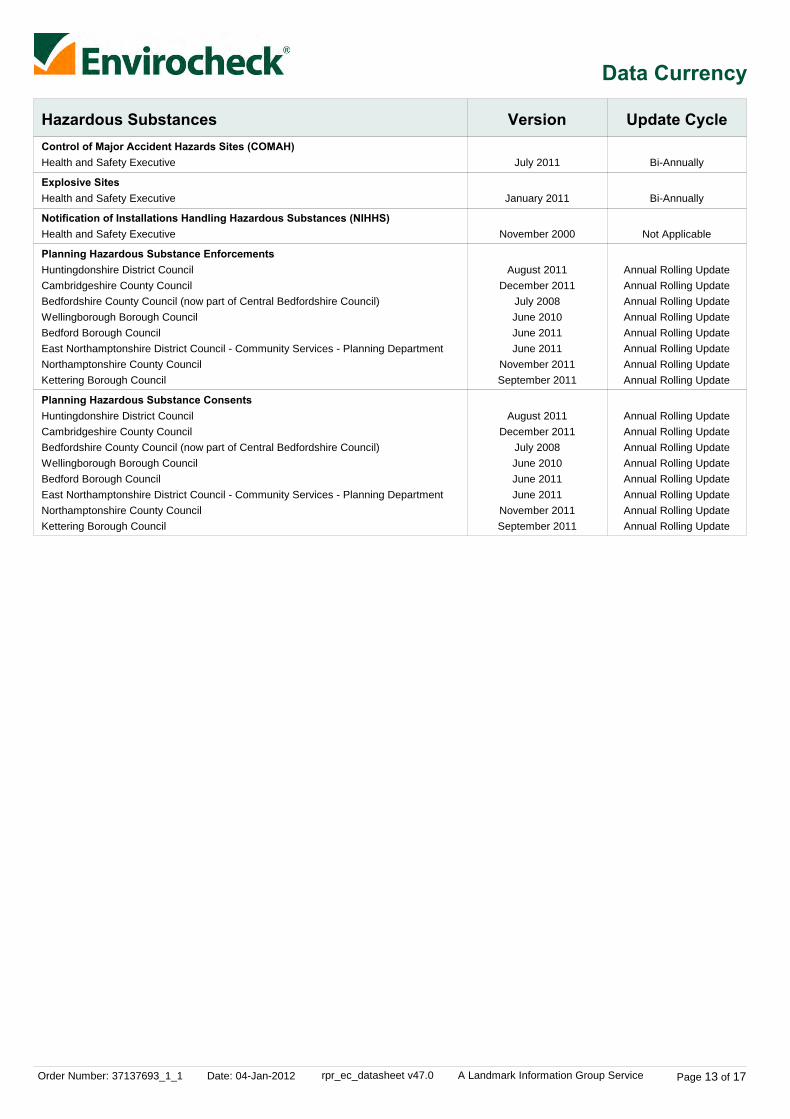
Order Number: 37137693_1_1 Date: 04-Jan-2012 rpr_ec_datasheet v47.0 A Landmark Information Group Service Page 13 of 17
Data Currency
Hazardous Substances Version Update CycleControl of Major Accident Hazards Sites (COMAH)
Explosive Sites
Notification of Installations Handling Hazardous Substances (NIHHS)
Planning Hazardous Substance Enforcements
Planning Hazardous Substance Consents
July 2011
January 2011
November 2000
August 2011December 2011
July 2008June 2010June 2011June 2011
November 2011September 2011
August 2011December 2011
July 2008June 2010June 2011June 2011
November 2011September 2011
Bi-Annually
Bi-Annually
Not Applicable
Annual Rolling UpdateAnnual Rolling UpdateAnnual Rolling UpdateAnnual Rolling UpdateAnnual Rolling UpdateAnnual Rolling UpdateAnnual Rolling UpdateAnnual Rolling Update
Annual Rolling UpdateAnnual Rolling UpdateAnnual Rolling UpdateAnnual Rolling UpdateAnnual Rolling UpdateAnnual Rolling UpdateAnnual Rolling UpdateAnnual Rolling Update
Health and Safety Executive
Health and Safety Executive
Health and Safety Executive
Huntingdonshire District CouncilCambridgeshire County CouncilBedfordshire County Council (now part of Central Bedfordshire Council)Wellingborough Borough CouncilBedford Borough CouncilEast Northamptonshire District Council - Community Services - Planning DepartmentNorthamptonshire County CouncilKettering Borough Council
Huntingdonshire District CouncilCambridgeshire County CouncilBedfordshire County Council (now part of Central Bedfordshire Council)Wellingborough Borough CouncilBedford Borough CouncilEast Northamptonshire District Council - Community Services - Planning DepartmentNorthamptonshire County CouncilKettering Borough Council
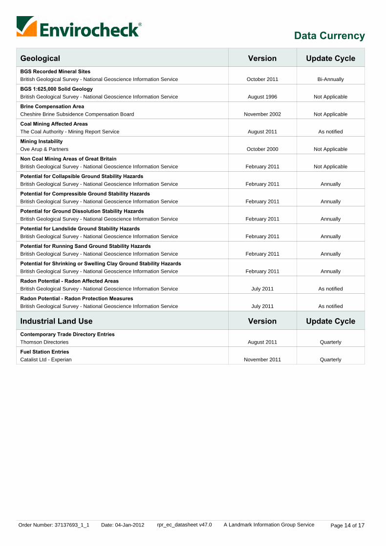
Order Number: 37137693_1_1 Date: 04-Jan-2012 rpr_ec_datasheet v47.0 A Landmark Information Group Service Page 14 of 17
Data Currency
Geological
Industrial Land Use
Version
Version
Update Cycle
Update Cycle
BGS Recorded Mineral Sites
BGS 1:625,000 Solid Geology
Brine Compensation Area
Coal Mining Affected Areas
Mining Instability
Non Coal Mining Areas of Great Britain
Potential for Collapsible Ground Stability Hazards
Potential for Compressible Ground Stability Hazards
Potential for Ground Dissolution Stability Hazards
Potential for Landslide Ground Stability Hazards
Potential for Running Sand Ground Stability Hazards
Potential for Shrinking or Swelling Clay Ground Stability Hazards
Radon Potential - Radon Affected Areas
Radon Potential - Radon Protection Measures
Contemporary Trade Directory Entries
Fuel Station Entries
October 2011
August 1996
November 2002
August 2011
October 2000
February 2011
February 2011
February 2011
February 2011
February 2011
February 2011
February 2011
July 2011
July 2011
August 2011
November 2011
Bi-Annually
Not Applicable
Not Applicable
As notified
Not Applicable
Not Applicable
Annually
Annually
Annually
Annually
Annually
Annually
As notified
As notified
Quarterly
Quarterly
British Geological Survey - National Geoscience Information Service
British Geological Survey - National Geoscience Information Service
Cheshire Brine Subsidence Compensation Board
The Coal Authority - Mining Report Service
Ove Arup & Partners
British Geological Survey - National Geoscience Information Service
British Geological Survey - National Geoscience Information Service
British Geological Survey - National Geoscience Information Service
British Geological Survey - National Geoscience Information Service
British Geological Survey - National Geoscience Information Service
British Geological Survey - National Geoscience Information Service
British Geological Survey - National Geoscience Information Service
British Geological Survey - National Geoscience Information Service
British Geological Survey - National Geoscience Information Service
Thomson Directories
Catalist Ltd - Experian
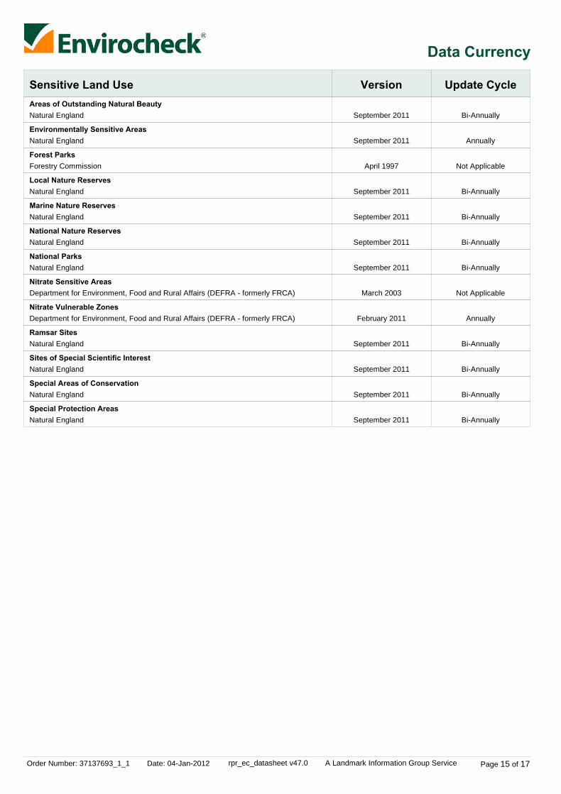
Order Number: 37137693_1_1 Date: 04-Jan-2012 rpr_ec_datasheet v47.0 A Landmark Information Group Service Page 15 of 17
Data Currency
Sensitive Land Use Version Update CycleAreas of Outstanding Natural Beauty
Environmentally Sensitive Areas
Forest Parks
Local Nature Reserves
Marine Nature Reserves
National Nature Reserves
National Parks
Nitrate Sensitive Areas
Nitrate Vulnerable Zones
Ramsar Sites
Sites of Special Scientific Interest
Special Areas of Conservation
Special Protection Areas
September 2011
September 2011
April 1997
September 2011
September 2011
September 2011
September 2011
March 2003
February 2011
September 2011
September 2011
September 2011
September 2011
Bi-Annually
Annually
Not Applicable
Bi-Annually
Bi-Annually
Bi-Annually
Bi-Annually
Not Applicable
Annually
Bi-Annually
Bi-Annually
Bi-Annually
Bi-Annually
Natural England
Natural England
Forestry Commission
Natural England
Natural England
Natural England
Natural England
Department for Environment, Food and Rural Affairs (DEFRA - formerly FRCA)
Department for Environment, Food and Rural Affairs (DEFRA - formerly FRCA)
Natural England
Natural England
Natural England
Natural England

Order Number: 37137693_1_1 Date: 04-Jan-2012 rpr_ec_datasheet v47.0 A Landmark Information Group Service Page 16 of 17
Data Suppliers
Ordnance Survey
Environment Agency
Scottish Environment Protection Agency
The Coal Authority
British Geological Survey
Centre for Ecology and Hydrology
Countryside Council for Wales
Scottish Natural Heritage
Natural England
Health Protection Agency
Ove Arup
Peter Brett Associates
Data Supplier Data Supplier Logo
A selection of organisations who provide data within this report

Order Number: 37137693_1_1 Date: 04-Jan-2012 rpr_ec_datasheet v47.0 A Landmark Information Group Service Page 17 of 17
Useful Contacts
Contact Name and Address Contact Details
1
2
3
4
5
6
-
-
Environment Agency - National Customer ContactCentre (NCCC)
British Geological Survey - Enquiry Service
Natural England
Department for Environment, Food and Rural Affairs(DEFRA - formerly FRCA)
Northamptonshire County Council
East Northamptonshire District Council - CommunityServices - Planning Department
Health Protection Agency - Radon Survey, Centre forRadiation, Chemical and Environmental Hazards
Landmark Information Group Limited
PO Box 544, Templeborough, Rotherham, S60 1BY
British Geological Survey, Kingsley Dunham Centre, Keyworth,Nottingham, Nottinghamshire, NG12 5GG
Northminster House, Northminster Road, Peterborough, Cambridgeshire,PE1 1UA
Government Buildings, Otley Road, Lawnswood, Leeds, West Yorkshire,LS16 5QT
County Hall, Northampton, Northamptonshire, NN1 1DN
East Northampton House, Cedar Drive, Thrapston, Kettering,Northamptonshire, NN14 4LZ
Chilton, Didcot, Oxfordshire, OX11 0RQ
The Smith Centre, Henley On Thames, Oxfordshire, RG9 6AB
Telephone: 08708 506 506Email: [email protected]
Telephone: 0115 936 3143Fax: 0115 936 3276Email: [email protected]: www.bgs.ac.uk
Telephone: 0845 600 3078Fax: 01733 455103Email: [email protected]: www.naturalengland.org.uk
Telephone: 0113 2613333Fax: 0113 230 0879
Telephone: 01604 236236Website: www.northamptonshire.gov.uk
Telephone: 01832 742000Fax: 01832 000000Website: www.east-northamptonshire.gov.uk
Telephone: 01235 822622Fax: 01235 833891Email: [email protected]: www.hpa.org.uk
Telephone: 0844 844 9952Fax: 0844 844 9951Email: [email protected]: www.landmarkinfo.co.uk
Please note that the Environment Agency / SEPA have a charging policy in place for enquiries.


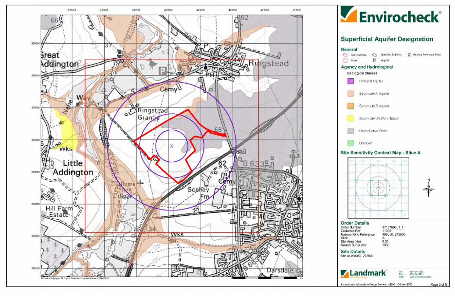
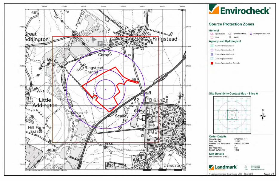


Order Details
Site DetailsSite at 498050, 273900
Order Number:Customer Ref:National Grid Reference:Slice:Site Area (Ha):Plot Buffer (m):
37137693_1_111093498050, 273900A0.01250
Tel:Fax:Web:
0844 844 99520844 844 9951www.envirocheck.co.uk
Page 1 of 1A Landmark Information Group Service v46.0 04-Jan-2012
Site Sensitivity Map - Segment A13


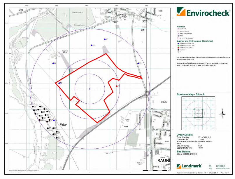

Order Details
Site DetailsSite at 498050, 273900
Order Number:Customer Ref:National Grid Reference:Site Area (Ha):Search Buffer (m):
37137693_1_111093498050, 2739000.011000
Tel:Fax:Web:
0844 844 99520844 844 9951www.envirocheck.co.uk
Page 1 of 3A Landmark Information Group Service v46.0 04-Jan-2012
Index Map
Slice
Segment
Quadrant
Client Details
For ease of identification, your site and buffer have been split into Slices,Segments and Quadrants. These are illustrated on the Index Map oppositeand explained further below.
Each slice represents a 1:10,000 plot area (2.7km x 2.7km) for your site andbuffer. A large site and buffer may be made up of several slices (representedby a red outline), that are referenced by letters of the alphabet, starting fromthe bottom left corner of the slice "grid". This grid does not relate to NationalGrid lines but is designed to give best fit over the site and buffer.
A segment represents a 1:2,500 plot area. Segments that have plot filesassociated with them are shown in dark green, others in light blue. These arenumbered from the bottom left hand corner within each slice.
A quadrant is a quarter of a segment. These are labelled as NW, NE, SW,SE and are referenced in the datasheet to allow features to be quickly locatedon plots. Therefore a feature that has a quadrant reference of A7NW will bein Slice A, Segment 7 and the NW Quadrant.
A selection of organisations who provide data within this report:
Envirocheck reports are compiled from 136 different sources of data.
Dr D Blythe, DAB Geotechnics, 3, Tweed Avenue,Ellington, MORPETH, Northumberland, NE61 5ES
Page 2 of 3
DEFINITIONS
Basis of Contract
Services and Licensed Use
Intellectual Property and Confidentiality
Termination
Payments
Liability1.
2.
3.
4.
5.
6.a.
b.
c.
d.
e.
a.
b.
i.
ii.
iii.
iv.
v.
vi.
c.
d.
e.
f.
g.
h.
i.
j.
a.
b.
a.
i.
ii.
b.
i.
ii.
iii.
iv.
a.
b.
c.
d.
a.
b.
i.
ii.
iii.c.
d.
e.
f.
g.
LANDMARK STANDARD TERMS AND CONDITIONSVersion 6.05 5 Nov 2011
In these Terms, the following terms have thefollowing meanings:"Agreement" has the meaning set out in clause1.d."Authorised Reseller" means an agent orreseller who We have duly appointed to resellOur Reports and Services."Consumer" means a natural person acting forpurposes other than his trade, business orprofession."Content" means any data, computing andinformation services and software, and othercontent and documentation or supportmaterials and updates included in and/orsupplied by or through the Websites, in Reportsor Services or in any other way by Us and shallinclude both material developed by or on behalfof Us and Third Party Content."End User" means either: (i) a Consumer or aConsumer's friend or family member who usesthe Services provided to the Consumer; or (ii)where You are not a Consumer, an employeeof Yours who uses the Services provided toYou; or (iii) a person identified in clause 2.b ortheir respective employees."Fees" means any charges levied by Us or anAuthorised Reseller for Services provided toYou."First Purchaser" means the first person, orlegal entity to purchase the Property Sitefollowing provision of a Report."First Purchaser's Lender" means the fundingprovider for the First Purchaser."Information Pack" means a pack compiled byor on behalf of the owner or prospective buyerof the Property Site, designed to aid themarketing or purchase of the Property Site andcontaining information provided by or on behalfof the owner or prospective buyer of theProperty Site."Intellectual Property Rights" means copyright,patent, design right (registered or unregistered),service or trade mark (registered orunregistered), database right or other dataright, moral right or know how or any otherintellectual property right.References to "We", "Us" and "Our" arereferences to Landmark Information GroupLimited, whose registered office is 7 AbbeyCourt, Eagle Way, Exeter, EX2 7HY."Order" means the request for Services fromUs by You."Property Site" means a land site in relation towhich We provide a Service."Report" includes any information that Wesupply to You including all reports, services,datasets, software or information contained inthem."Services" means the provision of any serviceby Us pursuant to these Terms, includingwithout limitation, any Report. "Supplier" means any third party organisationthat provides services, software, data,information and other content or functionality ofany form to Us."Terms" means these terms and conditions."Third Party Content" means the services,software, data, information and other content orfunctionality provided by Suppliers and linked toor contained in the Services."Website" means any website hosted by Usand includes the Content and any report,service, document, data-set, software orinformation contained in such websites orderived from them.References to "You", "Your" and "Yourself"
refer to the contracting party who accesses theWebsite or places an Order with Us.
These Terms govern the relationshipbetween Us and You where You purchaseServices from Us. Where these Terms arenot expressly accepted by You, they will bedeemed to have been accepted by You,and You agree to be bound by theseTerms, when You place any Order, or payfor any Services provided to You by Us.You shall take all reasonable steps tocheck that the details that You provide inrelation to Your Order are complete,accurate and correct and that the Reporthas been prepared for the correct locationand property type. Neither We nor anySuppliers shall have any liability for errorsor omissions in information provided by oron behalf of You or from Your failure tocheck that the Report relates to the correctlocation or property.We may modify these Terms, and maydiscontinue or revise any or all otheraspects of the Services at Our solediscretion, with immediate effect andwithout prior notice, including withoutlimitation changing the Services availableat any given time. Any amendment orvariation to these Terms shall be posted onOur Websites. You acknowledge that itshall remain Your responsibility to checkOur Website from time to time for any suchamendments or variation to these Terms.Continued Orders of the Services by Youshall be deemed an acceptance by You tobe bound by any such amendments to theTerms. These Terms together with Your Order, theFees and delivery details in relation to YourOrder and Our privacy policy, which isavailable on the Website, constitute theentire agreement between the partiesrelating to the supply of Services to You byUs ("Agreement"). You acknowledge thatYou have not relied on any statement,promise or representation made or givenby or on behalf of Us which is not set out inthe Agreement or delivery details. Nothingin this clause 1.d shall limit or exclude anyliability for fraud.These Terms shall prevail at all times tothe exclusion of all other terms andconditions including any terms andconditions which You may purport to applyeven if such other provisions are submittedin a later document or purport to exclude oroverride these Terms and neither thecourse of conduct between parties nortrade practice shall act to modify theseTerms.
Subject to clauses 6.d, 6.k and 6.l, Weshall use all reasonable skill, care anddiligence in the performance of theServices.Subject always to these Terms You may,without further charge, make the Servicesavailable to:
the owner of the whole or part of theProperty Site at the date of the Report;any person who purchases the wholeor part of the Property Site;
any person who provides fundingsecured on the whole or part of theProperty Site;any person for whom You act in aprofessional or commercial capacity inrelation to the Property Site;any person who acts for You in aprofessional or commercial capacity inrelation to the Property Site; and/orprospective buyers of the whole orpart of the Property Site as part of anInformation Pack but for the avoidanceof doubt, We shall have no liability tosuch prospective buyer unless theprospective buyer subsequentlypurchases the Property Site, and theprospective (or actual) buyer shall notbe entitled to make the Serviceavailable to any other third party.
You shall not hold yourself out or describeyourself as Our agent or an agent of any ofthe Suppliers.You shall ensure that acknowledgementsof copyright and database right ownershipare included in a conspicuous position inall copies of the Content. You may notdelete any of Our or the Suppliers'intellectual property protection notices(including without limitation copyrightnotices or trade marks) from the Content.You shall use Your best endeavours to useadequate technological and securitymeasures, including measures We orSuppliers may reasonably recommendfrom time to time, to ensure that allContent which You hold or are responsiblefor is secure from unauthorised use oraccess.The Content shall only be used strictly inaccordance with these Terms and not forany other purpose; nor shall any use of theContent be made that would or might bedeemed to be disparaging to Us, theSuppliers or any of them. You shall not beentitled to resell or rent any Content orotherwise any supply productsincorporating such Content for commercialsale or rental.You shall not reverse engineer, separate orotherwise tamper with the Content so thatContent can be extracted and used for anypurpose outside the scope of theAgreement.If You are a Company or public body, Youagree that the licensed use of Contentpursuant to the Agreement alwaysexcludes its use by any of Yoursubsidiaries, holding companies orsubsidiaries of such holding companies (assuch terms are defined in section 1159 ofthe Companies Act 2006) or by anygovernment entity associated with You (ineach case as applicable). You agree, andshall procure, that any such company orentity shall enter into a separateagreement with Us.All other uses of the Content areprohibited. If You wish to use the Contentin a manner which is not authorised by theTerms, then You must contact Us to seekthe necessary consents or licences (whichmay include further licences from theSuppliers), for which there may beadditional Fees.You agree to notify Us as soon as Yoususpect any infringement of Our or any of
Our Supplier's intellectual property rightsand You agree to give Us all reasonablyrequired assistance in pursuing anypotential infringement.
You acknowledge and agree that allIntellectual Property Rights in Content areand shall continue to be owned by Us orOur Suppliers and nothing in theAgreement shall transfer, assign or grantany rights to You (save for the licence asset out above).Subject to any use of the Content inaccordance with these Terms, Youacknowledge and agree that You shall, andshall procure that any person to whom Youprovide access to the Content shall, treatas strictly private and confidential theServices, the Content and all informationwhich they obtain from the Services andContent. You agree to indemnify Usagainst all liabilities, damages, penalties,costs, expenses (including legal expenseson an indemnity basis) or other losssuffered or incurred by Us in relation to anybreach or alleged breach of this clause 3.b.
At any time, We may terminate theAgreement with immediate effect by givingYou written notice:
if You are in breach of the Terms and,if such breach is capable of remedy,You fail to remedy the breach within30 days of written notice from Usspecifying the breach and requiring itto be remedied; andif You have a receiver oradministrative receiver oradministrator appointed over You orany part of Your undertaking or assetsor shall pass a resolution for windingup (otherwise than for the purpose of abona fide scheme of solventamalgamation or reconstruction) or if acourt of competent jurisdiction shallmake an order to that effect or if Youbecome subject to an administrationorder or enter into a voluntaryarrangement with Your creditors orshall cease or threaten to cease tocarry on business or if You arepresented with a bankruptcy petition.
In the event of the termination or expiry ofthe Agreement:
You shall, subject to clause 4.b.iii,immediately cease to use the Reportand any Content;You shall, subject to clause 4.b.iii,within 30 days of such termination orexpiry, destroy all Content in anymedia which You hold or for whichYou are responsible and provide, atOur request, a sworn statement by aduly authorised person that You nolonger hold such Content;except in the event of termination byUs under clause 4.a, You may retainContent in an archive following expiryof the Agreement for the sole purposeof addressing a complaint or challengefrom a regulator or other third partyregarding Your use of such Contentduring the term of the Agreement.Your rights are on condition that: (a)
the archive rights do not apply toContent that include third partyIntellectual Property Rights (other thanContent provided by Ordnance Surveyto the extent that the IntellectualProperty Rights in such Content areowned by Ordnance Survey); (b) Youshall not disclose Content retainedunder this clause 4.b.iii to anyregulator or other third party exceptstrictly to the extent necessary for therelevant purpose of addressing acomplaint or challenge from aregulator or other third party and inpaper or read-only electronic formatonly; (c) You must store such Contentseparately from any other data whichYou hold; and (d) subject to clause6.a, We shall have no liability for Youruse of it following termination or expiryof the Agreement; andthe parties shall have no furtherobligations or rights under theAgreement, without prejudice to thosewhich have accrued to either partyprior to termination or expiry save thatthe "Definitions", clauses 2.c to 2.j(inclusive), this clause 4.b, clauses5.d, 6, 7, 9, 10 and 11 together withthose other clauses the survival ofwhich is necessary for theinterpretation or enforcement of theAgreement or which by their naturecan be reasonably interpreted assurviving the expiry or termination ofthe Agreement, shall continue to haveeffect after such expiry or termination.
An individual or a monthly invoice showingall Orders created by You will be generatedsubject to these Terms. You will pay theFees at the rates set out in Our or OurAuthorised Reseller's invoice within 30days of the date of each invoice withoutdeduction, counterclaim or set off. WhereYour order comprises a number ofServices or severable elements within anyone or more Services, any failure by Us orits Authorised Reseller to provide anelement or elements of the Services shallnot prejudice Our or Our AuthorisedReseller's ability to require payment inrespect of the Services delivered to You.You acknowledge that time is of theessence with respect to the payment ofsuch invoices.VAT shall be due in addition to any Fees.You shall pay any other applicable indirecttaxes related to Your use of the Services.Neither We nor any Authorised Resellershall be required to notify You in advanceof any amendment to the Fees and theplacing of any further Order for Servicesshall be deemed acceptance of anyrevisions to the Fees.If You fail to pay by the due date anyamount due and payable by You under theAgreement, We shall be entitled, but notobliged to, charge You interest on theoverdue amount, payable by Youimmediately on demand, accruing from thedue date up to the date of actual payment,after as well as before judgment, at therate set out in the Late Payment ofCommercial Debts (Interest) Act 1998 fromtime to time and fixed sum compensation
under the Late Payment of CommercialDebts Regulations 2002. Such interestshall accrue on a daily basis.
Nothing in these Terms excludes or limitseither party's liability for death or personalinjury caused by that party's negligence orwilful default or for fraud, and theremainder of this clause 6 is subject to thisprovision. If You are a Consumer, Yourstatutory rights (which include, forexample, that We will provide the Servicesto a reasonable standard and within areasonable time) are not affected byanything in these Terms.Save as set out in clause 6.a, We shall notbe liable to You or to any End User incontract, tort (including negligence) or forbreach of statutory duty or in any other wayfor:
any indirect or consequential losses(which includes any loss that could nothave been reasonably expected byYou and Us at the time of entering intothese Terms);loss arising from or in connection withloss of revenues, profits, contracts orbusiness or failure to realiseanticipated savings; orloss of goodwill or reputation.
Save as set out in clause 6.a, Our totalliability to You and/or any End User incontract or tort (including negligence) or forbreach of statutory duty shall not exceedan amount of ten million pounds(£10,000,000) per claim or series ofconnected claims.The Content that Services are based on isderived from third party sources.Therefore, save as set out in clause 6.l inrespect of risk assessments andprofessional opinions, We do not warrantthe accuracy or completeness of anyinformation or Content provided, unlessWe should reasonably have been alertedto any omission, error or inaccuracy in theContent. Such Content is providedspecifically from the sources as describedby Us and We do not claim that theserepresent an exhaustive or comprehensivelist of all sources that might be consulted.You acknowledge and agree that neitherYou nor any End User shall have any claimor recourse against any Supplier of ThirdParty Content.You acknowledge and agree that We donot warrant that the online supply ofContent or Services or any internetordering service will be: uninterrupted orerror free or provide any particular facilitiesor functions; free from defects; free fromsoftware viruses; free of error fromcomputer malfunction, inaccurateprocessing; free from corruption of datawhilst geo-coding, processing by computeror electronic means or in the course oftransmission; or similar, although We willuse reasonable endeavours to correct anysuch issues within a reasonable period ofthem becoming known (which may belimited to notifying the relevant Supplier).Time shall not be of the essence inproviding the Content or Services.You acknowledge and agree that nophysical inspection of the Property Site

Page 3 of 3
Contribution
Assignment and Sub-contracting
Events Beyond Our Control
Complaints and Dispute Resolution
General
7.
8.
9.
10.
11.h.
i.
j.
k.
l.
m.
n.
a.
b.
c.
i.
ii.
iii.
iv.
d.
e.
f.
g.
h.
i.
a.
b.
c.
a.
a.
b.
c.
i.
ii.
a.
b.
c.
d.
e.
f.
Landmark Information Group Limited, 7 Abbey Court, Eagle Way, Exeter, EX2 7HY Email: [email protected]© Landmark Information Group Limited
Order Number: 37137693 A Landmark Information Group Service
reported on is carried out as part of anyServices offered by Us and We do notwarrant that all land uses or featureswhether past or current will be identified inthe Services. The Services do not includeany information relating to the actual stateor condition of any Property Site nor shouldthey be used or taken to indicate orexclude actual fitness or unfitness of aProperty Site for any particular purpose norshould it be relied upon for determiningsaleability or value or used as a substitutefor any physical investigation or inspection.You acknowledge and agree that We willnot be held liable in any way if a Report isused otherwise than as provided for inthese Terms and/or in the Report.You acknowledge and agree that theServices have not been prepared to meetYour or anyone else's individualrequirements and it is Your responsibility toensure that the Services ordered aresuitable for Your (or the End User's)intended purpose.You acknowledge and agree that Youshall, on receipt of a Report carry out areasonable inspection to satisfy Yourselfthat there are no apparent defects orfailures with respect to the description andlocation of the Property Site and shallpromptly inform Us if there are any suchdefects or failures.All liability for any insurance productspurchased by You rests solely with theinsurer. We do not endorse any particularproduct or insurer and no informationcontained within the Services should bedeemed to imply otherwise. Youacknowledge that if You Order any suchinsurance We will deem such as Yourconsent to forward a copy of the Report tothe insurers. Where such policy ispurchased, You acknowledge and agreethat all liability shall remain with theinsurers and that You are entirelyresponsible for ensuring that the insurancepolicy offered is suitable for Your needsand should seek independent advice. Wedo not guarantee that an insurance policywill be available on a Property Site. Youacknowledge and agree that all decisionswith regard to the offer of insurancepolicies for any premises will be madesolely at the discretion of the insurers andWe accept no liability in this regard. Theprovision of a Report does not constituteany indication by Us that insurance will beavailable on the Property Site.We may provide You with professionalopinions or a risk assessment in a Report.You acknowledge and agree that We shallcarry out (or procure that third parties carryout) such assessment with reasonable skilland care and that We shall be liable whereany such risk assessment is carried outnegligently. Notwithstanding the foregoingWe shall not be liable for any inaccuratestatement, opinion or risk rating in a Reportwhich resulted from a reasonableinterpretation of the Content.Neither You, nor any End User or anyother person may rely on a Service morethan 12 months after it was originallyprovided.You shall use all reasonable endeavours toensure that End Users acknowledge and
agree to the limitations and exclusions ofliability set out in this clause 6.
Save where expressly provided, this clause7 shall apply solely to EnvirosearchResidential Reports (regardless of theresult of such Report). Nothing in thisclause 7 shall operate to override or varythe provisions of clause 6.We are prepared to offer, without anyadmission or inference of liability, acontribution towards the costs of anyremediation works required under a Notice(as defined below) on the terms of thisclause 7 ("the Contribution").In the event that a Remediation Notice isserved on the First Purchaser or FirstPurchaser's Lender of a Property Siteunder Part IIA of the EnvironmentalProtection Act 1990 ("the Notice") We shallcontribute to the cost of such works aseither the First Purchaser or FirstPurchaser's Lender (but not both) arerequired to carry out under the Noticesubject to the provisions of this clause 7and on the following terms:
the Contribution shall only apply tocontamination or a pollution incidentpresent or having occurred prior to thedate of the Report; the Contribution shall only apply wherethe Property Site is a single residentialdwelling house or a single residentialflat within a block of flats. For theavoidance of doubt, this obligationdoes not apply to any commercialproperty, nor to any Property Sitebeing developed or redevelopedwhether for residential purposes orotherwise; the Contribution is strictly limited to thecost of works at the Property Site andat no other site; andthe Contribution will not be paid inrespect of any of the following: (1)radioactive contamination ofwhatsoever nature, directly orindirectly caused by or contributed toor arising from ionising radiations orcontamination by radioactivity fromany nuclear fuel or from any nuclearwaste from the combustion of nuclearfuel or the radioactive toxic explosiveor other hazardous properties of anyexplosive nuclear assembly or nuclearcomponent thereof; (2) asbestosarising out of or related in any way toasbestos or asbestos-containingmaterials on or in structures orservices serving the structures; (3)naturally occurring materials arisingfrom the presence or required removalof naturally occurring materials exceptin circumstances where suchmaterials are present inconcentrations which are in excess oftheir natural concentration; (4)intentional non-compliance arisingfrom the intentional disregard of orknowing wilful or deliberate non-compliance by any owner or occupierof the Property Site with any statute,regulation, administrative complaint,notice of violation, or notice letter ofany Regulatory Authority; (5) anycondition which is known or ought
reasonably to have been known to theFirst Purchaser or the FirstPurchaser's Lender prior to thepurchase of the Report; (6) anycondition which is caused by acts ofwar or an act of terrorism; (7) anyproperty belonging to or in the custodyor control of the First Purchaser whichdoes not form a fixed part of theProperty Site or the structure; (8) anyfines liquidated damages punitive orexemplary damages; (9) any bodilyinjury including without limitation,death, illness or disease, mentalinjury, anguish or nervous shock; (10)any financial loss in respect of anyloss of any rental, profit, revenue,savings or business or anyconsequential indirect or economicloss damage or expense including thecost of rent of temporary premises orbusiness interruption; and/or (11) anylosses incurred following a materialchange in use of, alteration ordevelopment of the Property Site.
Without prejudice to Your other rights andremedies under the Agreement, themaximum sum that shall be contributed byUs in respect of any Contribution shall belimited to £60,000. In the event that morethan one Report is purchased on theProperty Site the Contribution will only bepayable under the first Report purchasedby or on behalf of any First Purchaser orFirst Purchaser's Lender and noContribution will be made in respect ofsubsequent Reports purchased by or onbehalf of such First Purchaser, FirstPurchaser's Lender or any personconnected to them.We shall only pay a Contribution where theNotice is served within 36 months of theissue date of the Report.Any rights to a Contribution under thisclause 7 are not assignable in the event ofa sale of the Property Site and We shallnot make any Contribution after the date ofcompletion of such sale.In the event the First Purchaser or FirstPurchaser's Lender wishes to claim anyContribution, it shall notify Us in writingwithin 3 months of the date of the Notice.The First Purchaser or First Purchaser'sLender (as applicable) shall comply with allOur reasonable requirements with regardto the commission and conduct of theremediation works to be carried out underthe Notice, and in the event the FirstPurchaser or First Purchaser's Lender (asapplicable) does not do so, includingwithout limitation, obtaining Our priorwritten consent to any estimates for suchworks or complying with any otherreasonable request by Us, We shall not berequired to pay any Contribution.Notwithstanding the payment of theContribution by Us the First Purchaser orFirst Purchaser's Lender as applicableshall take all reasonable steps to mitigateany costs incurred in connection with theconduct of works required under the termsof any Notice.In the event that the First Purchaser orFirst Purchaser's Lender receives anycommunication from a statutory authorityto the effect that there is an intent to servea notice received under Part IIA of the
Environmental Protection Act 1990 Youshall ensure that they advise Us within amaximum period of two months fromreceipt of such communication. Thisclause 7.h and the service of any noticeunder it shall not affect the provisions ofclauses 7.e and 7.g, and any suchcommunications, even if advised to Us willnot operate as notice under clause 7.e.We reserve the right at any time prior to aclaim for Contribution being made inaccordance with clause 7.g above, towithdraw the offer of payment ofContributions without further notice.
We shall be entitled to assign or transferthe Agreement as We reasonably see fit.The Agreement is personal to You. Youshall not assign, transfer, sub-licence orotherwise deal with any of Your rights andobligations under the Agreement withoutOur prior written consent.We may authorise or allow Our contractorsand other third parties to provide to Usand/or to You services necessary orrelated to the Services and to perform Ourobligations and exercise Our rights underthese Terms, which may include collectingpayment on Our behalf.
Neither party to the Agreement shall beliable for any delay or failure to performtheir obligations caused by anycircumstance beyond their control, andsuch party shall be entitled to a reasonableextension of time for the performance ofsuch obligation.
Any complaints in relation to the Servicesshould, in the first instance, be in writingaddressed to the Customer ServiceSupport Manager at Our registered office.We will (or Our agents will) respond to anysuch complaints in writing as soon aspracticably possible.If any dispute arises out of or in connectionwith the Terms of the Agreement or theirvalidity ("Dispute") the parties undertake,subject to clause 10.c, that prior tocommencement of court proceedings theywill negotiate in good faith to settle suchDispute by mediation in accordance withthe Centre for Effective Dispute ResolutionModel Mediation Procedure as in forcefrom time to time, which Procedure isdeemed to be incorporated by referenceinto this clause. Unless otherwise agreedbetween the parties, the mediator will benominated by the Centre for EffectiveDispute Resolution. To initiate themediation a party shall give notice inwriting to the other party to the disputerequesting a mediation. The mediation willstart not later than 21 days after the date ofservice of such notice. If the Dispute hasnot been resolved to the mutualsatisfaction of the parties within 60 days(or such other period as they shall agree)after the date of service of such notice theneither party may refer the Dispute to thecourts in accordance with clause 11.f.Clause 10.b shall be without prejudice to
the rights of termination stated in clause4.a and in addition shall not prevent Usfrom:
applying for injunctive relief in the caseof: (1) breach or threatened breach ofconfidentiality; or (2) infringement orthreatened infringement of Our or OurSuppliers' intellectual property rights;orpursuing a debt claim for the paymentof the Fees.
If any provision of the Agreement is foundby either a court or other competentauthority to be void, invalid, illegal orunenforceable, that provision shall bedeemed to be deleted from the Agreementand never to have formed part of theAgreement and the remaining provisionsshall continue in full force and effect.No delay, failure or omission on Our, orany Supplier's, part in enforcing, exercisingor pursuing any right, power, privilege,claim or remedy conferred by or arisingunder the Agreement or by law shall bedeemed to be or construed as a waiver ofthat or any other right, power, privilege,claim or remedy, nor shall any single orpartial exercise of any such right, power,privilege, claim or remedy preclude theexercise of that or any other right, power,privilege, claim or remedy.Our privacy policy as displayed on OurWebsite and updated from time to timegoverns the use that We shall make of anyinformation provided by You or an EndUser.A person who is not a party to any contractmade pursuant to these Terms shall haveno right under the Contract (Rights of ThirdParties) Act 1999 to enforce any terms ofthe Agreement and We shall not be liableto any such third party in respect of theProducts, save that any Supplier mayenforce any of these terms and conditionsagainst You in accordance with theContracts (Rights of Third Parties) Act1999. Notwithstanding any other provisionsof the Agreement, We may rescind or varythe Agreement in accordance with itsterms without the consent of the Suppliersand accordingly section 2(1) of theContracts (Rights of Third Parties) Act1999 shall not apply.You shall ensure that each End Usercomplies with and is bound by the Termsand shall procure that We may in Our ownright enforce such terms and conditionsagainst the End User pursuant to theContracts (Rights of Third Parties) Act1999. You shall be responsible for EndUser's compliance with the Terms and Youshall be liable for all breaches of the Termsby the End Users as if they were breachesby You.The Agreement and any non-contractualobligations arising out of or in connectionwith it shall be governed by and construedin accordance with the laws of Englandand, subject to clause 10.b, each partyirrevocably submits to the exclusivejurisdiction of the courts of England andWales.

Proposed Ringstead Grange Quarry - Hydrological and Hydrogeological Assessment
DABGeot/11093/Final
Reproduced with the Permission of Controller of H. M. Stationery Office © Crown Copyright. All rights reserved. Licence No. WL1005542 DAB Geotechnics.
Extracts of Environment Agency Flood & Flood Warning Maps (from Environment Agency internet website)
DAB Geotechnics Proposed Ringstead Grange Quarry Date: January 2012
Warning of flooding from rivers

Proposed Ringstead Grange Quarry - Hydrological and Hydrogeological Assessment
DABGeot/11093/Final
APPENDIX B
Correspondence with East Northamptonshire Council

View message - Webmail - Email - Messaging - Services - O2 - [email protected]
http://www.mail.o2.co.uk/...k&sh=&fp=INBOX&mappos=2&fi=&bid=&u=davidblythe735822&an=davidblythe735822%40o2.co.uk&t=75d21&uid=92&pid=11&ss=[04/01/2012 17:44:33]
HelloDAVID Sign Out
O2 Business
My O2
View my mobile bill
My personal details
My Business Account
My broadband
O2 Webmail
O2 Email to Mobile
Calendar
Online Address Book
My Online Accounts
Send a free text message
Bluebook
My picture messages
Blueroom
From:To:
Subject:Date:
O2 [email protected] Get your email forwarded to your mobile with O2 Email to Mobile
Webmail Help|SettingsInbox Compose Folders Notifications
Reply Reply to All Forward Delete Move message to Please select...
| Previous email | Next email
Mandy Dennis [[email protected]] (save address) "'[email protected]'"<[email protected]> RE: Private Water Supplies Jan 4, 2012 12:17
Dear David, We have no records of any private water supplies within 1km of the boundary of the site as marked on the plan. RegardsMandy
Mandy DennisEnvironmental Protection OfficerEast Northamptonshire Council01832 742037
From: Customer Services Sent: 03 January 2012 09:16To: Environmental ServicesSubject: FW: Private Water Supplies
From: David Blythe [mailto:[email protected]] Sent: 27 December 2011 12:08To: Customer ServicesSubject: Private Water Supplies
Dear Sir/Madam,
I am acting on behalf of Mick George Ltd. This company proposes to develop a new quarry on land to the south of Ringstead Grange Farm. In order to assess the possible impact of this development on surface and groundwaters, I should be grateful if you could provide details of any private water supplies within the area that extends up to 1km from its boundary (e.g. location, abstractor's name, volume and use. I appreciate that you may not be able to supply all of this information for reasons of confidentiality.) The attached plan shows the site boundary and the corresponding search area.
Yours faithfully,
David Blythe
DAB Geotechnics
______________________________________________________________________
Warning: Although East Northamptonshire Council has taken reasonable precautions to ensure no viruses are present inthis e-mail, the Council cannot accept responsibility for any loss or damage arising from the use of this e-mail orattachments. This e-mail, including any attachments, is intended for the exclusive use of the addressee. It may containinformation which is legally privileged, confidential and exempt from disclosure. Any views or opinions expressed in thise-mail do not necessarily represent those of East Northamptonshire District Council and are not to be relied uponwithout subsequent written confirmation by an authorised representative. If you are not the addressee any disclosure,reproduction, distribution, forwarding or other dissemination or use is strictly prohibited. If you have received this inerror please notify East Northamptonshire District Council.
East Northamptonshire Council, Cedar Drive, Northants, NN14 4LZ. Telephone +44 (0) 1832 742000______________________________________________________________________
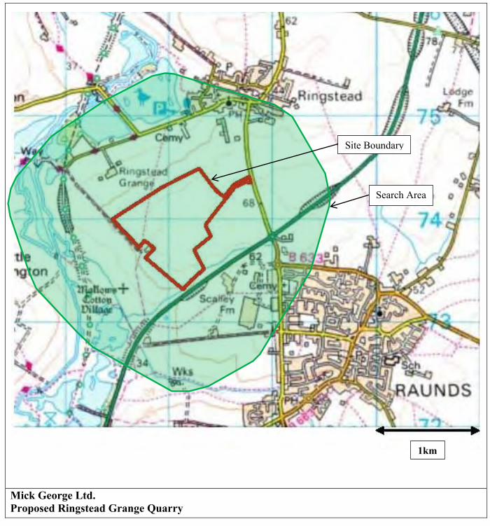
Mick George Ltd. Proposed Ringstead Grange Quarry
1km
Site Boundary
Search Area
DBlythe
Text Box
Reproduced with the Permission of Controller of H. M. Stationery Office © Crown Copyright. All rights reserved. Licence No. WL1005542 DAB Geotechnics.

Proposed Ringstead Grange Quarry - Hydrological and Hydrogeological Assessment
DABGeot/11093/Final
APPENDIX C
Scoping Opinion from the Environment Agency

Northamptonshire County Council: Planning Development Control PO Box 163 County Hall Northampton NN1 1AX FAO Mr P Watson
Our ref: AN/2011/113241/01-L02 Your ref: 11/0005.SCO/FRI116 Date: 08 November 2011
Dear Sir
Proposals for scope and content of an application for a proposed limestone quarry including extraction of clay and the deposit of inert waste for
restoration purposes Ringstead Grange Ringstead
Thank you for your Environmental Impact Assessment (EIA) Scoping consultation, which was received on 17 October 2011. We have reviewed the scoping report submitted and our technical comments detailing the information we consider should be provided in the Environmental Statement (ES) are provided below. Technical comments and advice Hydrology and Hydrogeology Sections 17 and 18 of the Scoping Opinion acknowledges that the hydrology and hydrogeology of the site needs to be investigated to provide baseline conditions and identify any water features which should be provided in a Flood Risk Assessment (FRA). From the information provided we can confirm that the site is greater than 1.0 ha and lies within Flood Zones 1 (low probability of river and sea flooding as defined in Annex D Planning Policy Statement 25 ‘Development and Flood Risk’ (PPS25)). In order to fully assess the issue of flood risk, a fully compliant PPS 25 - Annex E FRA must be undertaken and submitted with any planning application, which considers and quantifies the different types of flooding as well as addressing the surface water drainage for the development. Please note the FRA should address the various phases of development (from mineral extraction through to restoration). The FRA should form part of the EIA or be submitted as a standalone
Environment Agency Nene House (Pytchley Lodge Industrial Estate), Pytchley Lodge Road, Kettering, Northants, NN15 6JQ Email: [email protected] www.environment-agency.gov.uk
Customer services line: 03708 506 506 Weekday daytime calls to 0370 numbers cost 8p plus up to 6p per minute from BT Weekend Unlimited. Mobile and other providers’ charges may vary.
Cont/d..

Cont/d..
2
document. General FRA comments The FRA must consider and quantify the different types of flooding to demonstrate that flood risk is not increased by the proposed development and where possible, reduced. Surface water run-off issues are a key factor for consideration. Any FRA must demonstrate that surface water run-off can be managed for both, construction and restoration and that the proposed surface water drainage system can cope with 1 in 100 probability plus climate change rainfall event without increasing flood risk to the site, surrounding area and third parties. The FRA must also demonstrate that construction and post development run-off does not exceed pre-development run-off. Within the FRA, surface water run-off rates for the existing and developed site for the 1 in 1 probability rainfall event, the 1 in 30 probability rainfall event and the 1 in 100 probability rainfall event and the attenuation volumes required including an allowance for climate change should be stated. In addition, any FRA must confirm whether the site run-off will be restricted to the Qbar rate for all events or the Q1 for the 1 in 1 probability rainfall event, Q30 for the 1 in 30 probability rainfall event and Q100 for the 1 in 100 probability rainfall event using a complex control. Any attenuation required should be provided in line with the requirements of PPS25 and Preliminary Rainfall Runoff Management for New Development Revision D. The drainage scheme proposed should provide a sustainable drainage strategy to include SUDS elements with attenuation. The maintenance and/or adoption proposals for every element of the surface water drainage system proposed on the site should be considered for the lifetime of the development and the residual risk of flooding addressed. The FRA should also consider the possibility that the surface water system may fail / become blocked. Overland floodwater flood water should be routed away from vulnerable areas. For acceptable depths and rates of flow, please refer to Environment Agency and Defra document FD2320/TR2 “Flood Risk Assessment Guidance for New Development Phase 2”. Further consideration should be given to safe access and egress for emergency services when site is flooded. Environmental permitting The restoration by inert landfilling element of development associated with this development will require an Environmental Permit under the Environmental Permitting Regulations 2010, from the Environment Agency, unless an exemption applies. The Applicant is advised to contact the Environment Agency on 08708 506 506 for further advice and to discuss the issues likely to be raised. You should be aware that the permit may not be granted. Additional ‘Environmental Permitting Guidance’ can be accessed via our main website ( http://www.environment-agency.gov.uk ). We ask that our Pollution Prevention Guidelines, are considered. These guidance notes are available to download from: http://www.environment-agency.gov.uk/business/topics/pollution/39083.aspx The comments we set out above are without prejudice to future decisions we make regarding any applications subsequently made to us for our permits or consents for operations at the site.

Should you require any additional information, or to discuss matters further, please do not hesitate to contact me on the number below. Yours sincerely Kerrie Ginns Planning Liaison Officer Direct dial 01536 385159 Direct e-mail [email protected]
Awarded to the Planning and Corporate Services Department of Anglian Region, Northern Area
End
3
Proposed Ringstead Grange Quarry - Hydrological and Hydrogeological Assessment
DABGeot/11093/Final
APPENDIX D
1/10,000 Scale Geological Maps
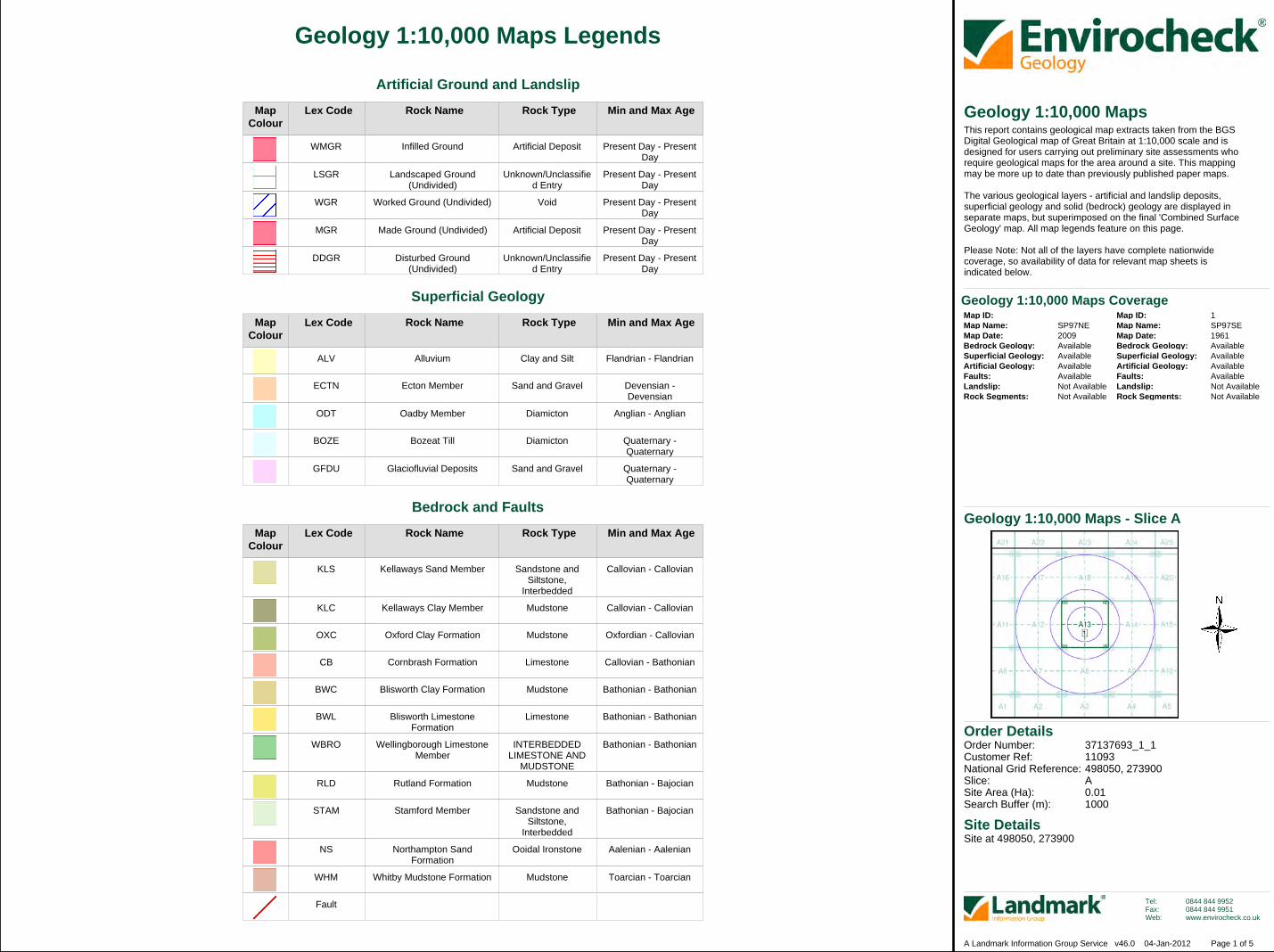
Order Details
Site DetailsSite at 498050, 273900
Order Number:Customer Ref:National Grid Reference:Slice:Site Area (Ha):Search Buffer (m):
37137693_1_111093498050, 273900A0.011000
Tel:Fax:Web:
0844 844 99520844 844 9951www.envirocheck.co.uk
Page 1 of 5A Landmark Information Group Service v46.0 04-Jan-2012
Geology 1:10,000 Maps Legends
MapColour
MapColour
MapColour
Lex Code
Lex Code
Lex Code
Rock Name
Rock Name
Rock Name
Rock Type
Rock Type
Rock Type
Min and Max Age
Min and Max Age
Min and Max Age
WMGR
LSGR
WGR
MGR
DDGR
ALV
ECTN
ODT
BOZE
GFDU
KLS
KLC
OXC
CB
BWC
BWL
WBRO
RLD
STAM
NS
WHM
Fault
Infilled Ground
Landscaped Ground(Undivided)
Worked Ground (Undivided)
Made Ground (Undivided)
Disturbed Ground(Undivided)
Alluvium
Ecton Member
Oadby Member
Bozeat Till
Glaciofluvial Deposits
Kellaways Sand Member
Kellaways Clay Member
Oxford Clay Formation
Cornbrash Formation
Blisworth Clay Formation
Blisworth LimestoneFormation
Wellingborough LimestoneMember
Rutland Formation
Stamford Member
Northampton SandFormation
Whitby Mudstone Formation
Artificial Deposit
Unknown/Unclassified Entry
Void
Artificial Deposit
Unknown/Unclassified Entry
Clay and Silt
Sand and Gravel
Diamicton
Diamicton
Sand and Gravel
Sandstone andSiltstone,
Interbedded
Mudstone
Mudstone
Limestone
Mudstone
Limestone
INTERBEDDEDLIMESTONE AND
MUDSTONE
Mudstone
Sandstone andSiltstone,
Interbedded
Ooidal Ironstone
Mudstone
Present Day - PresentDay
Present Day - PresentDay
Present Day - PresentDay
Present Day - PresentDay
Present Day - PresentDay
Flandrian - Flandrian
Devensian -Devensian
Anglian - Anglian
Quaternary -Quaternary
Quaternary -Quaternary
Callovian - Callovian
Callovian - Callovian
Oxfordian - Callovian
Callovian - Bathonian
Bathonian - Bathonian
Bathonian - Bathonian
Bathonian - Bathonian
Bathonian - Bajocian
Bathonian - Bajocian
Aalenian - Aalenian
Toarcian - Toarcian
Artificial Ground and Landslip
Superficial Geology
Bedrock and Faults
Geology 1:10,000 MapsThis report contains geological map extracts taken from the BGSDigital Geological map of Great Britain at 1:10,000 scale and isdesigned for users carrying out preliminary site assessments whorequire geological maps for the area around a site. This mappingmay be more up to date than previously published paper maps.
The various geological layers - artificial and landslip deposits,superficial geology and solid (bedrock) geology are displayed inseparate maps, but superimposed on the final 'Combined SurfaceGeology' map. All map legends feature on this page.
Please Note: Not all of the layers have complete nationwidecoverage, so availability of data for relevant map sheets isindicated below.
Geology 1:10,000 Maps - Slice A
Map ID:Map Name:Map Date:Bedrock Geology:Superficial Geology:Artificial Geology:Faults:Landslip:Rock Segments:
Map ID:Map Name:Map Date:Bedrock Geology:Superficial Geology:Artificial Geology:Faults:Landslip:Rock Segments:
SP97NE2009AvailableAvailableAvailableAvailableNot AvailableNot Available
1SP97SE1961AvailableAvailableAvailableAvailableNot AvailableNot Available
Geology 1:10,000 Maps Coverage
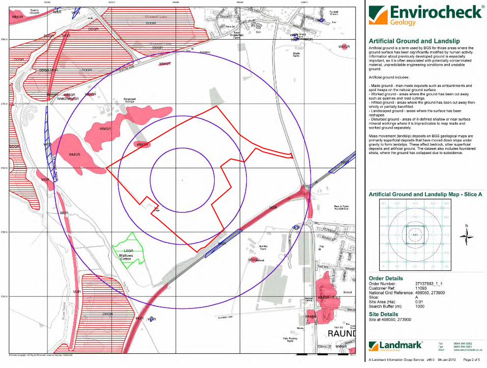
Proposed Ringstead Grange Quarry - Hydrological and Hydrogeological Assessment
DABGeot/11093/Final

Proposed Ringstead Grange Quarry - Hydrological and Hydrogeological Assessment
DABGeot/11093/Final

Proposed Ringstead Grange Quarry - Hydrological and Hydrogeological Assessment
DABGeot/11093/Final

Proposed Ringstead Grange Quarry - Hydrological and Hydrogeological Assessment
DABGeot/11093/Final
Order Number: 37137693_1_1 Date: 04-Jan-2012 rpr_ec_datasheet v47.0 A Landmark Information Group Service
BGS BoreholesDatasheet
Order Details:Order Number:
Customer Reference:
National Grid Reference:
Slice:
Site Area (Ha):
Borehole Search Buffer (m):
Site Details:
Client Details:
37137693_1_1
11093
498050, 273900
A
0.01
1000
Site at 498050, 273900
Dr D BlytheDAB Geotechnics3, Tweed AvenueEllingtonMORPETHNorthumberlandNE61 5ES
Report:®Envirocheck
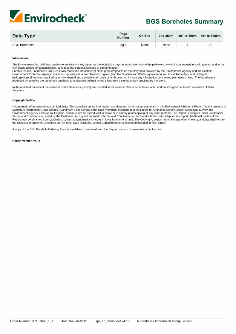
Order Number: 37137693_1_1 Date: 04-Jan-2012 rpr_ec_datasheet v47.0 A Landmark Information Group Service
BGS Boreholes Summary
Data Type PageNumber On Site 0 to 250m 251 to 500m 501 to 1000m
BGS Boreholes None None 1 29pg 1
Introduction
Copyright Notice
The Environment Act 1995 has made site sensitivity a key issue, as the legislation pays as much attention to the pathways by which contamination could spread, and to thevulnerable targets of contamination, as it does the potential sources of contamination. For this reason, Landmark's Site Sensitivity maps and Datasheet(s) place great emphasis on statutory data provided by the Environment Agency and the ScottishEnvironment Protection Agency; it also incorporates data from Natural England (and the Scottish and Welsh equivalents) and Local Authorities; and highlightshydrogeological features required by environmental and geotechnical consultants. It does not include any information concerning past uses of land. The datasheet isproduced by querying the Landmark database to a distance defined by the client from a site boundary provided by the client.
In the attached datasheet the National Grid References (NGRs) are rounded to the nearest 10m in accordance with Landmark's agreements with a number of DataSuppliers.
© Landmark Information Group Limited 2012. The Copyright on the information and data and its format as contained in this Envirocheck® Report ("Report") is the property ofLandmark Information Group Limited ("Landmark") and several other Data Providers, including (but not limited to) Ordnance Survey, British Geological Survey, theEnvironment Agency and Natural England, and must not be reproduced in whole or in part by photocopying or any other method. The Report is supplied under Landmark'sTerms and Conditions accepted by the Customer. A copy of Landmark's Terms and Conditions can be found with the index Map for this report. Additional copies of theReport may be obtained from Landmark, subject to Landmark's charges in force from time to time. The Copyright, design rights and any other intellectual rights shall remainthe exclusive property of Landmark and /or other Data providers, whose Copyright material has been included in this Report. A copy of the BGS Borehole Ordering Form is available to download from the Support section of www.envirocheck.co.uk.
Report Version v47.0

Order Number: 37137693_1_1 Date: 04-Jan-2012 rpr_ec_datasheet v47.0 A Landmark Information Group Service Page 1 of 3
BGS Boreholes Detail
MapID Details
QuadrantReference(CompassDirection)
EstimatedDistanceFrom Site
Contact NGR
11
12
13
14
15
16
17
17
18
19
20
21
22
23
24
25
BGS Boreholes
BGS Boreholes
BGS Boreholes
BGS Boreholes
BGS Boreholes
BGS Boreholes
BGS Boreholes
BGS Boreholes
BGS Boreholes
BGS Boreholes
BGS Boreholes
BGS Boreholes
BGS Boreholes
BGS Boreholes
BGS Boreholes
BGS Boreholes
A14NW(E)
A12NE(W)
A18NE(N)
A17SE(NW)
A7NE(SW)
A7NW(SW)
A7NE(SW)
A7NE(SW)
A12SW(SW)
A7NW(SW)
A7NW(SW)
A18NE(N)
A12SW(W)
A7NW(SW)
A7NE(SW)
A7NW(SW)
453
519
727
744
797
803
814
825
831
838
859
863
881
888
895
895
2
2
2
2
2
2
2
2
2
2
2
2
2
2
2
2
BGS Reference:Drilled Length (m):Borehole Name:
BGS Reference:Drilled Length (m):Borehole Name:
BGS Reference:Drilled Length (m):Borehole Name:
BGS Reference:Drilled Length (m):Borehole Name:
BGS Reference:Drilled Length (m):Borehole Name:
BGS Reference:Drilled Length (m):Borehole Name:
BGS Reference:Drilled Length (m):Borehole Name:
BGS Reference:Drilled Length (m):Borehole Name:
BGS Reference:Drilled Length (m):Borehole Name:
BGS Reference:Drilled Length (m):Borehole Name:
BGS Reference:Drilled Length (m):Borehole Name:
BGS Reference:Drilled Length (m):Borehole Name:
BGS Reference:Drilled Length (m):Borehole Name:
BGS Reference:Drilled Length (m):Borehole Name:
BGS Reference:Drilled Length (m):Borehole Name:
BGS Reference:Drilled Length (m):Borehole Name:
Sp97se1631.39Addington Ii Sa 12d/2150
Sp97se46Caprons Ringstead Royalty
Sp97se485Caprons Ringstead Estate Th.2
Sp97se475.03Caprons Ringstead Estate Th.1
Sp97se1114.9Raunds
Sp97se517Not SuppliedStanwick Merrick Land 84
Sp97se534Not SuppliedStanwick Merrick Land 101
Sp97se506Not SuppliedStanwick Arc Land 73
Sp97se519Not SuppliedStanwick Merrick Land 86
Sp97se516Not SuppliedStanwick Merrick Land 83
Sp97se518Not SuppliedStanwick Merrick Land 85
Sp97se15Caprons Ringstead Estate No.3
Sp97se521Not SuppliedStanwick Merrick Land 88
Sp97se520Not SuppliedStanwick Merrick Land 87
Sp97se505Not SuppliedStanwick Arc Land 72
Sp97se507Not SuppliedStanwick Arc Land 74
498500273950
497540274000
498080274630
497440274330
497450273380
497340273530
497420273390
497440273350
497290273570
497360273430
497310273470
498300274730
497220273610
497250273520
497440273250
497340273360

Order Number: 37137693_1_1 Date: 04-Jan-2012 rpr_ec_datasheet v47.0 A Landmark Information Group Service Page 2 of 3
BGS Boreholes Detail
MapID Details
QuadrantReference(CompassDirection)
EstimatedDistanceFrom Site
Contact NGR
25
26
27
28
29
30
31
32
33
33
34
35
36
37
BGS Boreholes
BGS Boreholes
BGS Boreholes
BGS Boreholes
BGS Boreholes
BGS Boreholes
BGS Boreholes
BGS Boreholes
BGS Boreholes
BGS Boreholes
BGS Boreholes
BGS Boreholes
BGS Boreholes
BGS Boreholes
A7NW(SW)
A7SE(SW)
A19SE(NE)
A7NW(SW)
A7NW(W)
A7NW(SW)
A7NW(SW)
A7SE(SW)
A7NW(SW)
A7NW(SW)
A7SE(SW)
A12SW(W)
A7NW(W)
A7NW(SW)
899
902
916
927
927
951
959
971
976
980
983
995
996
1000
2
2
2
2
2
2
2
2
2
2
2
2
2
2
BGS Reference:Drilled Length (m):Borehole Name:
BGS Reference:Drilled Length (m):Borehole Name:
BGS Reference:Drilled Length (m):Borehole Name:
BGS Reference:Drilled Length (m):Borehole Name:
BGS Reference:Drilled Length (m):Borehole Name:
BGS Reference:Drilled Length (m):Borehole Name:
BGS Reference:Drilled Length (m):Borehole Name:
BGS Reference:Drilled Length (m):Borehole Name:
BGS Reference:Drilled Length (m):Borehole Name:
BGS Reference:Drilled Length (m):Borehole Name:
BGS Reference:Drilled Length (m):Borehole Name:
BGS Reference:Drilled Length (m):Borehole Name:
BGS Reference:Drilled Length (m):Borehole Name:
BGS Reference:Drilled Length (m):Borehole Name:
Sp97se535Not SuppliedStanwick Merrick Land 102
Sp97se504Not SuppliedStanwick Arc Land 71
Sp97se1168.9Raunds
Sp97se515Not SuppliedStanwick Merrick Land 82
Sp97se522Not SuppliedStanwick Merrick Land 89
Sp97se514Not SuppliedStanwick Merrick Land 81
Sp97se501Not SuppliedStanwick Arc Land 68
Sp97se513Not SuppliedStanwick Arc Land 80
Sp97se502Not SuppliedStanwick Arc Land 69
Sp97se523Not SuppliedStanwick Merrick Land 90
Sp97se508Not SuppliedStanwick Arc Land 75
Sp97se525Not SuppliedStanwick Merrick Land 92
Sp97se526Not SuppliedStanwick Merrick Land 93
Sp97se527Not SuppliedStanwick Walker Land 94
497320273380
497500273190
498860274330
497260273420
497190273560
497210273460
497350273250
497440273150
497240273360
497210273400
497500273090
497100273610
497120273550
497140273490
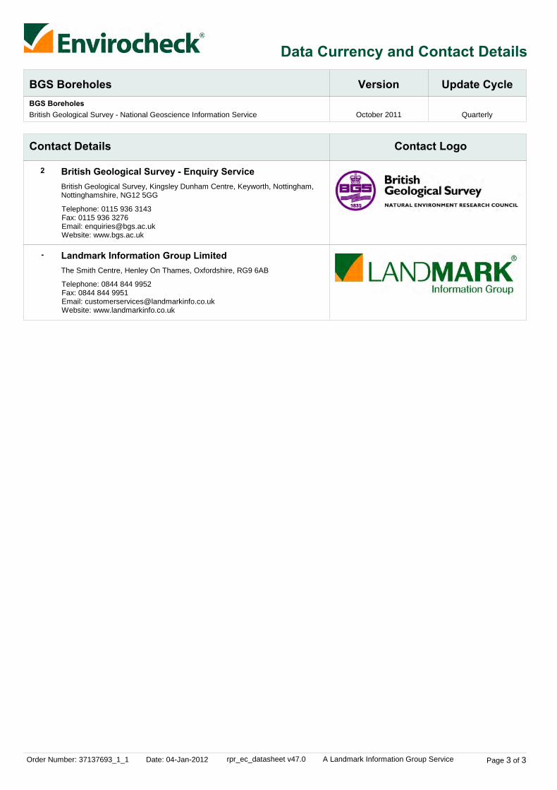
Order Number: 37137693_1_1 Date: 04-Jan-2012 rpr_ec_datasheet v47.0 A Landmark Information Group Service Page 3 of 3
Data Currency and Contact Details
BGS Boreholes Version Update CycleBGS Boreholes
October 2011 QuarterlyBritish Geological Survey - National Geoscience Information Service
Contact Details Contact Logo
2
-
British Geological Survey - Enquiry Service
Landmark Information Group Limited
British Geological Survey, Kingsley Dunham Centre, Keyworth, Nottingham,Nottinghamshire, NG12 5GG
The Smith Centre, Henley On Thames, Oxfordshire, RG9 6AB
Telephone: 0115 936 3143Fax: 0115 936 3276Email: [email protected]: www.bgs.ac.uk
Telephone: 0844 844 9952Fax: 0844 844 9951Email: [email protected]: www.landmarkinfo.co.uk
Proposed Ringstead Grange Quarry - Hydrological and Hydrogeological Assessment
DABGeot/11093/Final
APPENDIX E
BGS Archive Borehole Records

Page 1 | Borehole SP97NE164 | Borehole Logs
http://scans.bgs.ac.uk/sobi_scans/boreholes/362652/images/10668770.html[16/12/2011 10:28:26]
Report an issue with this borehole
<< < Prev Next > >>Page 1 of 1
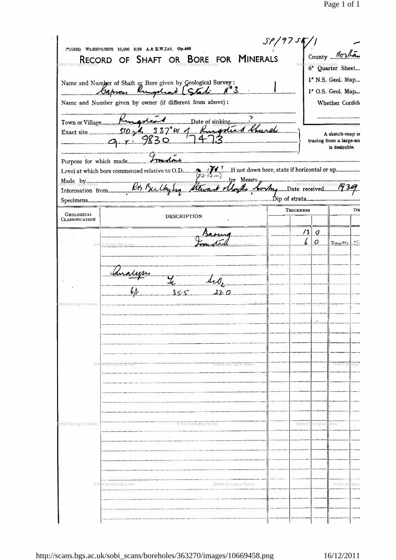
Page 1 of 1
16/12/2011http://scans.bgs.ac.uk/sobi_scans/boreholes/363270/images/10669458.png
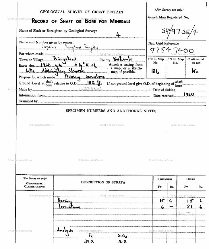
Page 1 | Borehole SP97SE4 | Borehole Logs
http://scans.bgs.ac.uk/sobi_scans/boreholes/363273/images/10669461.html[16/12/2011 10:31:43]
Report an issue with this borehole
<< < Prev Next > >>Page 1 of 1

Page 1 | Borehole SP97SE16 | Borehole Logs
http://scans.bgs.ac.uk/sobi_scans/boreholes/363285/images/10669465.html[16/12/2011 10:38:16]
Report an issue with this borehole
<< < Prev Next > >>Page 1 of 1
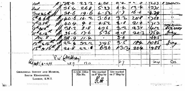
Page 1 | Borehole SP97SE16 | Borehole Logs
http://scans.bgs.ac.uk/sobi_scans/boreholes/363285/images/10669465.html[16/12/2011 10:38:16]
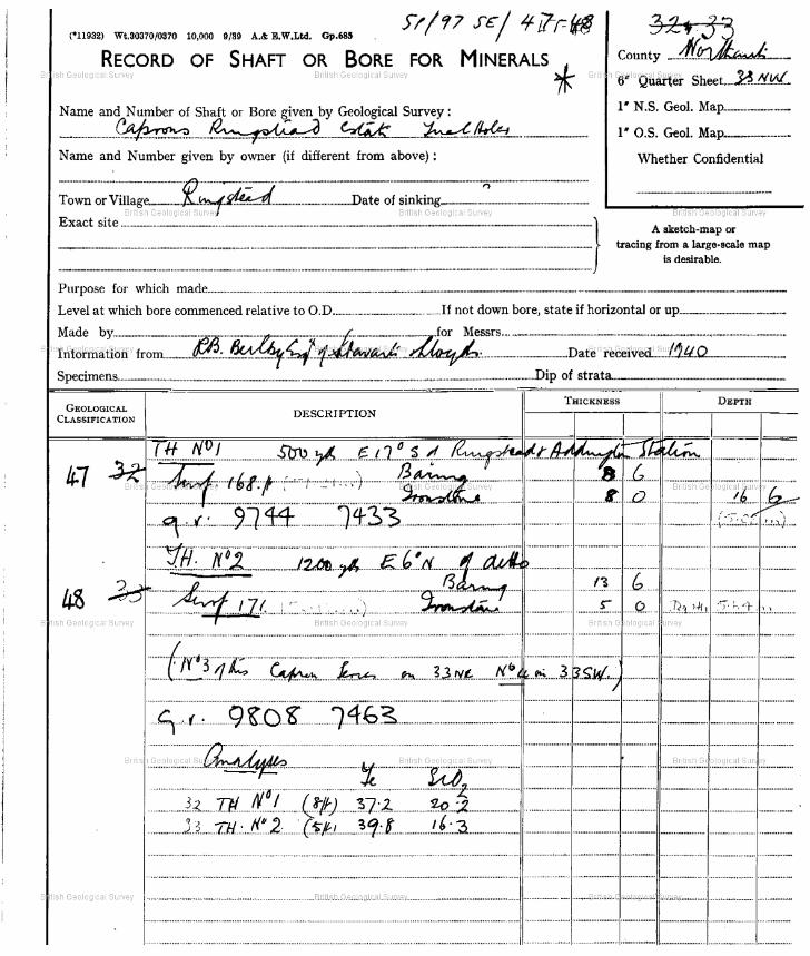
Page 1 | Borehole SP97SE47 | Borehole Logs
http://scans.bgs.ac.uk/sobi_scans/boreholes/363316/images/10669495.html[16/12/2011 10:25:57]
Report an issue with this borehole
<< < Prev Next > >>Page 1 of 1

Page 1 | Borehole SP97SE47 | Borehole Logs
http://scans.bgs.ac.uk/sobi_scans/boreholes/363316/images/10669495.html[16/12/2011 10:25:57]

Page 1 | Borehole SP97SE48 | Borehole Logs
http://scans.bgs.ac.uk/sobi_scans/boreholes/363317/images/10669495.html[16/12/2011 10:27:18]
Report an issue with this borehole
<< < Prev Next > >>Page 1 of 1

Page 1 | Borehole SP97SE48 | Borehole Logs
http://scans.bgs.ac.uk/sobi_scans/boreholes/363317/images/10669495.html[16/12/2011 10:27:18]

Page 1 | Borehole SP97SE112 | Borehole Logs
http://scans.bgs.ac.uk/sobi_scans/boreholes/363381/images/10669569.html[16/12/2011 10:35:51]
Report an issue with this borehole
<< < Prev Next > >>Page 1 of 1

Page 1 | Borehole SP97SE115 | Borehole Logs
http://scans.bgs.ac.uk/sobi_scans/boreholes/363384/images/10669572.html[16/12/2011 10:23:45]
Report an issue with this borehole
<< < Prev Next > >>Page 1 of 1

Page 1 | Borehole SP97SE116 | Borehole Logs
http://scans.bgs.ac.uk/sobi_scans/boreholes/363385/images/10669573.html[16/12/2011 10:24:48]
Report an issue with this borehole
<< < Prev Next > >>Page 1 of 1

Page 1 | Borehole SP97SE124 | Borehole Logs
http://scans.bgs.ac.uk/sobi_scans/boreholes/363393/images/10669584.html[16/12/2011 10:33:21]
Report an issue with this borehole
<< < Prev Next > >>Page 1 of 24

Proposed Ringstead Grange Quarry - Hydrological and Hydrogeological Assessment
DABGeot/11093/Final
APPENDIX F
Mining and Ground Stability Report
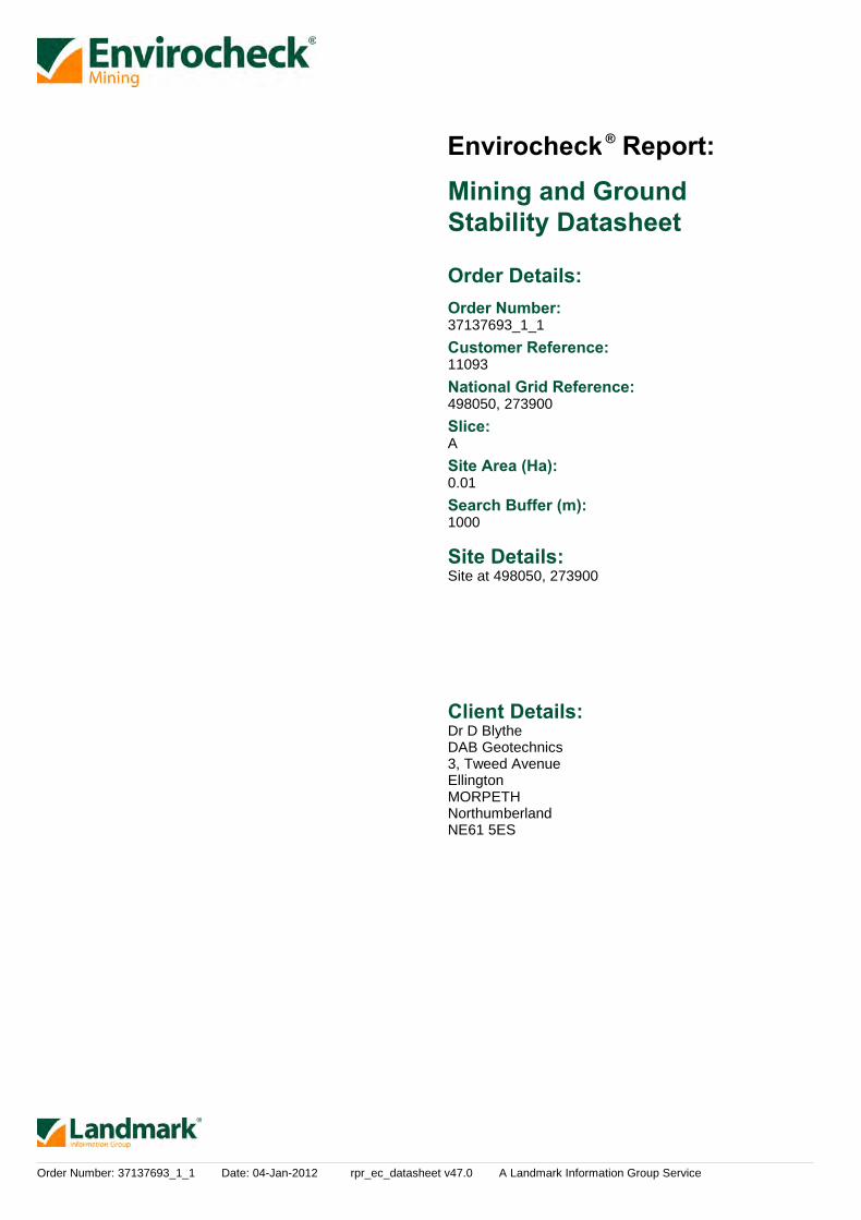
Order Number: 37137693_1_1 Date: 04-Jan-2012 rpr_ec_datasheet v47.0 A Landmark Information Group Service
Mining and GroundStability Datasheet
Order Details:Order Number:
Customer Reference:
National Grid Reference:
Slice:
Site Area (Ha):
Search Buffer (m):
Site Details:
Client Details:
37137693_1_1
11093
498050, 273900
A
0.01
1000
Site at 498050, 273900
Dr D BlytheDAB Geotechnics3, Tweed AvenueEllingtonMORPETHNorthumberlandNE61 5ES
Report:®Envirocheck
Order Number: 37137693_1_1 Date: 04-Jan-2012 rpr_ec_datasheet v47.0 A Landmark Information Group Service
Summary
Mining and Natural Cavities Data
Historical Land Use Information (1:2,500)
Historical Land Use Information (1:10,000)
Ground Stability Data (1:50,000)
Motion Map Data (1:2,500)
Historical Map List
Data Currency
Data Suppliers
Useful Contacts
Copyright Notice
© Landmark Information Group Limited 2012. The Copyright on the information and data and its format as contained in this Envirocheck®Report ("Report") is the property of Landmark Information Group Limited ("Landmark") and several other Data Providers, including (but notlimited to) Ordnance Survey, British Geological Survey, and the Environment Agency, and must not be reproduced in whole or in part byphotocopying or any other method. The Report is supplied under Landmark's Terms and Conditions accepted by the Customer. A copy of Landmark's Terms and Conditions can be found with the Index Map for this report. Additional copies of the Report may be obtainedfrom Landmark, subject to Landmark's charges in force from time to time. The Copyright, design rights and any other intellectual rights shallremain the exclusive property of Landmark and /or other Data providers, whose Copyright material has been included in this Report.
© Copyright Peter Brett Associates LLP & DCLG 2011. All rights reserved.
The brine subsidence data relating to the Driotwich area as provided in this report is derived from JPB studies and physical monitoringundertaken annually over more than 35 years. For more detailed interpretation contact [email protected]. JPB retain the copyright andintellectual rights to this data and accept no liability for any loss or damage, including in direct or consequential loss, arising from the use of thisdata.
Report Section and Details Page Number
Contents
Report Version v47.0
-
1
2
3
4
-
5
6
8
9
The Summary section provides an overview of the data contained within the report, detailing the number of data setfeatures or the existence of a data set in relation to the buffer selected.For ease of reference, the report is broken down into 4 sections of data; Mining and Natural Cavities Data, HistoricalLand Use Information (1:2,500), Historical Land Use Information (1:10,000) and Ground Stability Data (1:50,000).
The Mining and Natural Cavities Data section features data sets related to the existence of mining areas and theirpotential hazards; and details of naturally formed cavities.Data sets within this section are not plotted, with the exception of BGS Recorded Mineral Sites and Potential MiningAreas which feature on the Historical Land Use Information (1:10,000) map.
The Historical Land Use Information (1:2,500) section contains data captured from analysis carried out by Landmark of1:1,250 and 1:2,500 scale historical Ordnance Survey mapping, identifying areas where, historically, the land uses werepotentially contaminative.For the purpose of this Envirocheck module, only historical data relating to mining and ground stability has beenincluded and plotted on the corresponding Historical Land Use Information (1:2,500) map. This section also includes theSubterranean Features data set, which details various man-made and man-used underground spaces obtained from theSubterranea Britannica society.
The Historical Land Use (1:10,000) section covers data captured from the systematic analysis carried out by Landmarkof 1:10, 560 and 1:10,000 scale historical Ordnance Survey mapping dating back to the mid-19th century, identifyingpotentially contaminative past industrial land uses.For the purpose of this Envirocheck module, only data relating to mining and ground stability has been included andplotted on the accompanying Historical Land Use Information (1:10,000) map.
The Ground Stability (1:50,000) section includes the BGS Geosure data suite, reporting features to 250m and plottedonto 3 separate maps. Also reported is brine subsidence, brine mining and salt mining data sets, of which BrinePumping and Salt Mining Related Features are plotted, and subsidence insurance claims and insurance investigationsdata, which is not plotted.
The Motion Map Data (1:2,500) section contains data which is plotted to indicate long-term stability trends from analysisof satellite radar data.
The Historical Map List section details the historical mapping that has been analysed for your site, in relation to theHistorical Land Use Information sections.

Order Number: 37137693_1_1 Date: 04-Jan-2012 rpr_ec_datasheet v47.0 A Landmark Information Group Service
Summary
Data Type PageNumber On Site 0 to 250m 251 to 500m
Mining and Natural Cavities Data
Historical Land Use Information (1:2,500)
Historical Land Use Information (1:10,000)
501 to 1000m
BGS Recorded Mineral Sites
Coal Mining Affected Areas
Man Made Mining Cavities
Mining Instability
Natural Cavities
Non Coal Mining Areas of Great Britain
Potential Mining Areas
Extractive Industries or Potential Excavations from 1855-1909
Extractive Industries or Potential Excavations from 1893-1915
Extractive Industries or Potential Excavations from 1906-1937
Extractive Industries or Potential Excavations from 1924-1949
Extractive Industries or Potential Excavations from 1950-1980
Subterranean Features
Air Shafts
Disturbed Ground
General Quarrying
Heap, unknown constituents
Mineral Railway
Mining & quarrying general
Mining of coal & lignite
Quarrying of sand & clay, operation of sand & gravel pits
Former Marshes
Potentially Infilled Land (Non-Water)
Potentially Infilled Land (Water)
n/a
n/a
1
n/a
n/a
n/a
n/a
n/a
n/a
n/a
n/a
n/a
1
1
n/a
n/a
n/a
n/a
n/a
n/a
n/a
n/a
n/a
3
pg 1
pg 2
pg 3
pg 3
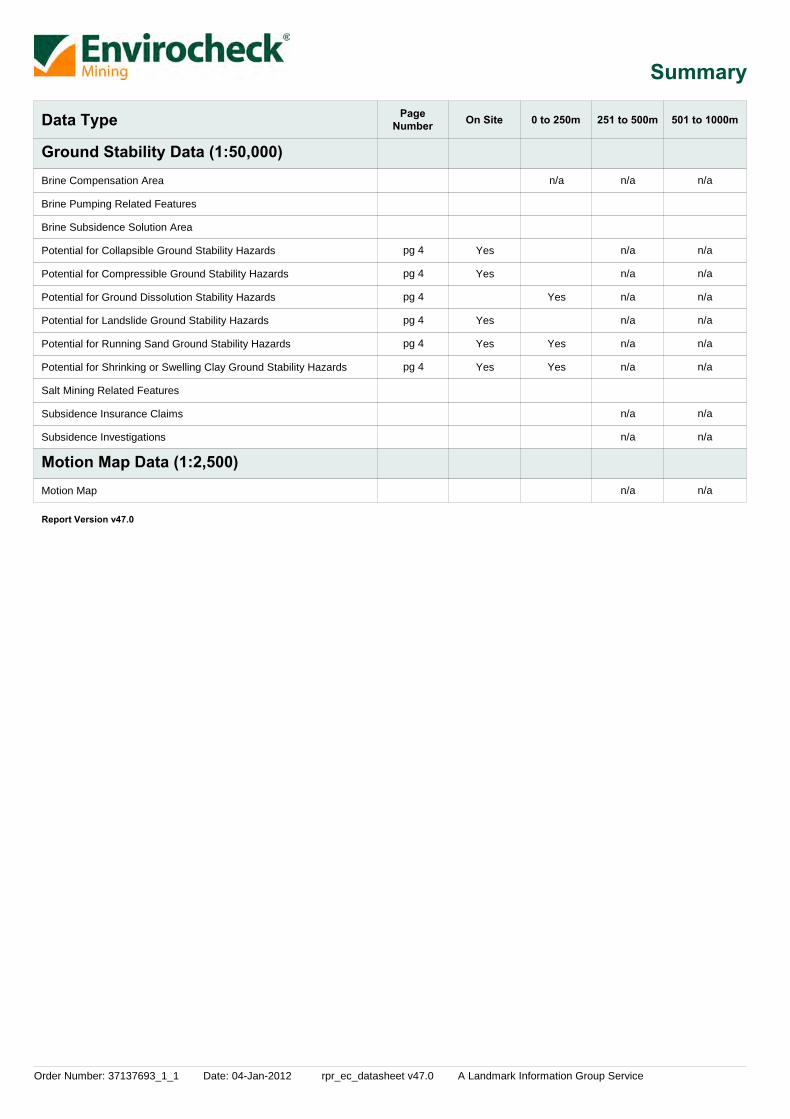
Order Number: 37137693_1_1 Date: 04-Jan-2012 rpr_ec_datasheet v47.0 A Landmark Information Group Service
Summary
Data Type PageNumber On Site 0 to 250m 251 to 500m
Ground Stability Data (1:50,000)
Motion Map Data (1:2,500)
501 to 1000m
Brine Compensation Area
Brine Pumping Related Features
Brine Subsidence Solution Area
Potential for Collapsible Ground Stability Hazards
Potential for Compressible Ground Stability Hazards
Potential for Ground Dissolution Stability Hazards
Potential for Landslide Ground Stability Hazards
Potential for Running Sand Ground Stability Hazards
Potential for Shrinking or Swelling Clay Ground Stability Hazards
Salt Mining Related Features
Subsidence Insurance Claims
Subsidence Investigations
Motion Map
Yes
Yes
Yes
Yes
Yes
n/a
Yes
Yes
Yes
n/a
n/a
n/a
n/a
n/a
n/a
n/a
n/a
n/a
n/a
n/a
n/a
n/a
n/a
n/a
n/a
n/a
n/a
n/a
n/a
pg 4
pg 4
pg 4
pg 4
pg 4
pg 4
Report Version v47.0

Order Number: 37137693_1_1 Date: 04-Jan-2012 rpr_ec_datasheet v47.0 A Landmark Information Group Service Page 1 of 9
Mining and Natural Cavities Data
MapID Details
QuadrantReference(CompassDirection)
EstimatedDistanceFrom Site
Contact NGR
1BGS Recorded Mineral Sites
Coal Mining Affected Areas
Non Coal Mining Areas of Great Britain
A9NE(E)
956 1Site Name:Location:Source:Reference:Type:Status:Operator:Operator Location:Periodic Type:Geology:Commodity:Positional Accuracy:
Scaley Farm PitScalley Farm, Raunds, NorthamptonshireBritish Geological Survey, National Geoscience Information Service120803OpencastCeasedUnknown OperatorNot SuppliedJurassicCornbrash FormationLimestoneLocated by supplier to within 10m
In an area which may not be affected by coal mining
No Hazard
498938273551

Order Number: 37137693_1_1 Date: 04-Jan-2012 rpr_ec_datasheet v47.0 A Landmark Information Group Service Page 2 of 9
Historical Land Use Information (1:2,500)
MapID Details
QuadrantReference(CompassDirection)
EstimatedDistanceFrom Site
Contact NGR
2Extractive Industries or Potential Excavations from 1950-1980
A13NE(N)
228 -Use:First Map PublishedDate:Last Map PublishedDate:
Pond1972
N/A
498135274115

Order Number: 37137693_1_1 Date: 04-Jan-2012 rpr_ec_datasheet v47.0 A Landmark Information Group Service Page 3 of 9
Historical Land Use Information (1:10,000)
MapID Details
QuadrantReference(CompassDirection)
EstimatedDistanceFrom Site
Contact NGR
3
4
5
6
Mineral Railway
Quarrying of sand & clay, operation of sand & gravel pits
Quarrying of sand & clay, operation of sand & gravel pits
Quarrying of sand & clay, operation of sand & gravel pits
A13NW(W)
A7SE(SW)
A17NE(NW)
A18NW(N)
296
946
995
1000
-
-
-
-
Use:Date of Mapping:
Use:Date of Mapping:
Use:Date of Mapping:
Use:Date of Mapping:
Not Supplied1887
Not Supplied1991
Not Supplied1991
Not Supplied1991
497774274009
497527273117
497633274807
497829274880

Order Number: 37137693_1_1 Date: 04-Jan-2012 rpr_ec_datasheet v47.0 A Landmark Information Group Service Page 4 of 9
Ground Stability Data (1:50,000)
MapID Details
QuadrantReference(CompassDirection)
EstimatedDistanceFrom Site
Contact NGR
7
8
9
10
11
12
13
14
15
16
Brine Compensation Area
Brine Subsidence Solution Area
Potential for Collapsible Ground Stability Hazards
Potential for Compressible Ground Stability Hazards
Potential for Ground Dissolution Stability Hazards
Potential for Ground Dissolution Stability Hazards
Potential for Ground Dissolution Stability Hazards
Potential for Landslide Ground Stability Hazards
Potential for Running Sand Ground Stability Hazards
Potential for Running Sand Ground Stability Hazards
Potential for Running Sand Ground Stability Hazards
Potential for Shrinking or Swelling Clay Ground Stability Hazards
Potential for Shrinking or Swelling Clay Ground Stability Hazards
Potential for Shrinking or Swelling Clay Ground Stability Hazards
Potential for Shrinking or Swelling Clay Ground Stability Hazards
Potential for Shrinking or Swelling Clay Ground Stability Hazards
A13NE(N)
A13NE(N)
A13NW(N)
A13SW(SW)
A13SE(E)
A13NE(N)
A13SE(SE)
A13SE(E)
A13NE(N)
A13NE(N)
A13SE(E)
A13NE(NE)
A13SE(SE)
A13SW(SW)
0
0
29
118
180
0
4
164
0
0
164
217
4
118
1
1
1
1
1
1
1
1
1
1
1
1
1
1
Hazard Potential:Source:
Hazard Potential:Source:
Hazard Potential:Source:
Hazard Potential:Source:
Hazard Potential:Source:
Hazard Potential:Source:
Hazard Potential:Source:
Hazard Potential:Source:
Hazard Potential:Source:
Hazard Potential:Source:
Hazard Potential:Source:
Hazard Potential:Source:
Hazard Potential:Source:
Hazard Potential:Source:
Very LowBritish Geological Survey, National Geoscience Information Service
No HazardBritish Geological Survey, National Geoscience Information Service
Very LowBritish Geological Survey, National Geoscience Information Service
Very LowBritish Geological Survey, National Geoscience Information Service
LowBritish Geological Survey, National Geoscience Information Service
Very LowBritish Geological Survey, National Geoscience Information Service
LowBritish Geological Survey, National Geoscience Information Service
Very LowBritish Geological Survey, National Geoscience Information Service
No HazardBritish Geological Survey, National Geoscience Information Service
ModerateBritish Geological Survey, National Geoscience Information Service
LowBritish Geological Survey, National Geoscience Information Service
ModerateBritish Geological Survey, National Geoscience Information Service
No HazardBritish Geological Survey, National Geoscience Information Service
No HazardBritish Geological Survey, National Geoscience Information Service
The site does not fall within the brine compensation area.
The site does not fall within the brine subsidence solution area.
498050273904
498050273904
498043273932
497969273819
498229273891
498050273904
498052273902
498203273847
498050273904
498050273904
498203273847
498176274081
498052273902
497969273819

Order Number: 37137693_1_1 Date: 04-Jan-2012 rpr_ec_datasheet v47.0 A Landmark Information Group Service Page 5 of 9
Historical Map List
Mapsheet
Mapsheet
Mapsheet
Published Date
Published Date
Published Date
1:2,500
1:10,560
1:10,000
Northamptonshire
Northamptonshire
Northamptonshire
Ordnance Survey Plan
Ordnance Survey Plan
Ordnance Survey Plan
Ordnance Survey Plan
Northamptonshire
Northamptonshire
Northamptonshire
Northamptonshire
Huntingdonshire
Northamptonshire
Northamptonshire
Northamptonshire
Northamptonshire
Huntingdonshire
Northamptonshire
Northamptonshire
Northamptonshire
Northamptonshire
Northamptonshire
Northamptonshire
Northamptonshire
Northamptonshire
Huntingdonshire
Ordnance Survey Plan
Ordnance Survey Plan
Ordnance Survey Plan
Ordnance Survey Plan
033_10
033_10
033_10
SP9873
SP9773
SP9774
SP9874
033_NW
033_SW
033_NE
033_SE
016A_NE
033_NE
033_NW
033_SE
033_SW
016A_NE
033_NE
033_NW
033_SE
033_SW
033_NE
033_NW
033_SE
033_SW
016A_NE
SP97NE
SP97SE
SP97SE
SP97NE
1885
1900
1926
1971
1972
1972
1972
1887
1888
1889
1889
1891
1901
1901
1901
1901
1902
1927
1927
1927
1927
1938
1938
1938
1938
1953
1958
1958
1991
1995
The following mapping has been analysed for Historical Land Use Information (1:2,500):
The following mapping has been analysed for Historical Land Use Information (1:10,000):

Order Number: 37137693_1_1 Date: 04-Jan-2012 rpr_ec_datasheet v47.0 A Landmark Information Group Service Page 6 of 9
Data Currency
Mining and Cavities Data
Historical Land Use Information (1:2,500)
Ground Stability Data (1:50,000)
Version
Version
Version
Update Cycle
Update Cycle
Update Cycle
BGS Recorded Mineral Sites
Coal Mining Affected Areas
Man Made Mining Cavities
Mining Instability
Natural Cavities
Non Coal Mining Areas of Great Britain
Subterranean Features
Brine Compensation Area
Potential for Collapsible Ground Stability Hazards
Potential for Compressible Ground Stability Hazards
Potential for Ground Dissolution Stability Hazards
Potential for Landslide Ground Stability Hazards
Potential for Running Sand Ground Stability Hazards
Potential for Shrinking or Swelling Clay Ground Stability Hazards
Subsidence Insurance Claims
Subsidence Investigations
October 2011
August 2011
November 2011
October 2000
November 2011
February 2011
July 2011
November 2002
February 2011
February 2011
February 2011
February 2011
February 2011
February 2011
May 2011
May 2011
Bi-Annually
As notified
Bi-Annually
Not Applicable
Bi-Annually
Not Applicable
Bi-Annually
Not Applicable
Annually
Annually
Annually
Annually
Annually
Annually
Quarterly
Quarterly
British Geological Survey - National Geoscience Information Service
The Coal Authority - Mining Report Service
Peter Brett Associates
Ove Arup & Partners
Peter Brett Associates
British Geological Survey - National Geoscience Information Service
Landmark Information Group Limited
Cheshire Brine Subsidence Compensation Board
British Geological Survey - National Geoscience Information Service
British Geological Survey - National Geoscience Information Service
British Geological Survey - National Geoscience Information Service
British Geological Survey - National Geoscience Information Service
British Geological Survey - National Geoscience Information Service
British Geological Survey - National Geoscience Information Service
SP Property Services
CET Group

Order Number: 37137693_1_1 Date: 04-Jan-2012 rpr_ec_datasheet v47.0 A Landmark Information Group Service Page 7 of 9
Data Currency
Motion Map Data (1:2,500) Version Update CycleMotion Map
February 2011January 2011January 2011January 2011January 2011
July 2010July 2010July 2010July 2010July 2010July 2010May 2009May 2009May 2009May 2009May 2009May 2009May 2009May 2009May 2009May 2009May 2009May 2009May 2009May 2009May 2009May 2009May 2009May 2009May 2009May 2009May 2009May 2009May 2009May 2009May 2009May 2009May 2009May 2009May 2009May 2009
November 2008September 2008
As notifiedAs notifiedAs notifiedAs notifiedAs notifiedAs notifiedAs notifiedAs notifiedAs notifiedAs notifiedAs notifiedAs notifiedAs notifiedAs notifiedAs notifiedAs notifiedAs notifiedAs notifiedAs notifiedAs notifiedAs notifiedAs notifiedAs notifiedAs notifiedAs notifiedAs notifiedAs notifiedAs notifiedAs notifiedAs notifiedAs notifiedAs notifiedAs notifiedAs notifiedAs notifiedAs notifiedAs notifiedAs notifiedAs notifiedAs notifiedAs notifiedAs notifiedAs notified
Nigel Press Associates - HampshireNigel Press Associates - CambridgeNigel Press Associates - IpswichNigel Press Associates - NorwichNigel Press Associates - PeterboroughNigel Press Associates - BarnstapleNigel Press Associates - DerbyshireNigel Press Associates - HumbersideNigel Press Associates - KentNigel Press Associates - LincolnshireNigel Press Associates - NottinghamshireNigel Press Associates - BirminghamNigel Press Associates - BournemouthNigel Press Associates - BrightonNigel Press Associates - BristolNigel Press Associates - CardiffNigel Press Associates - Central LondonNigel Press Associates - CheltenahmNigel Press Associates - CoventryNigel Press Associates - CrawleyNigel Press Associates - EdinburghNigel Press Associates - ExeterNigel Press Associates - GlasgowNigel Press Associates - Isle of WightNigel Press Associates - LeedsNigel Press Associates - LeicesterNigel Press Associates - LiverpoolNigel Press Associates - ManchesterNigel Press Associates - Milton KeynesNigel Press Associates - NewcastleNigel Press Associates - NorthwichNigel Press Associates - NottinghamNigel Press Associates - OxfordNigel Press Associates - PlymouthNigel Press Associates - PortsmouthNigel Press Associates - PrestonNigel Press Associates - ReadingNigel Press Associates - SheffieldNigel Press Associates - StokeNigel Press Associates - SwindonNigel Press Associates - TonbridgeNigel Press Associates - North LondonNigel Press Associates - Head Office
Order Number: 37137693_1_1 Date: 04-Jan-2012 rpr_ec_datasheet v47.0 A Landmark Information Group Service Page 8 of 9
Data Suppliers
Ordnance Survey
British Geological Survey
The Coal Authority
Ove Arup
Peter Brett Associates
Wardell Armstrong
Johnson Poole & Bloomer
Data Supplier Data Supplier Logo
A selection of organisations who provide data within this report

Order Number: 37137693_1_1 Date: 04-Jan-2012 rpr_ec_datasheet v47.0 A Landmark Information Group Service Page 9 of 9
Useful Contacts
Contact Name and Address Contact Details
1
-
British Geological Survey - Enquiry Service
Landmark Information Group Limited
British Geological Survey, Kingsley Dunham Centre, Keyworth,Nottingham, Nottinghamshire, NG12 5GG
The Smith Centre, Henley On Thames, Oxfordshire, RG9 6AB
Telephone: 0115 936 3143Fax: 0115 936 3276Email: [email protected]: www.bgs.ac.uk
Telephone: 0844 844 9952Fax: 0844 844 9951Email: [email protected]: www.landmarkinfo.co.uk
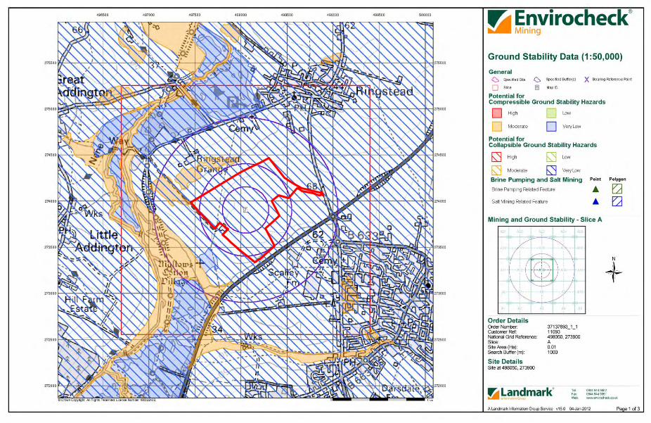
Proposed Ringstead Grange Quarry - Hydrological and Hydrogeological Assessment
DABGeot/11093/Final

Proposed Ringstead Grange Quarry - Hydrological and Hydrogeological Assessment
DABGeot/11093/Final

Proposed Ringstead Grange Quarry - Hydrological and Hydrogeological Assessment
DABGeot/11093/Final

Proposed Ringstead Grange Quarry - Hydrological and Hydrogeological Assessment
DABGeot/11093/Final

Proposed Ringstead Grange Quarry - Hydrological and Hydrogeological Assessment
DABGeot/11093/Final

Proposed Ringstead Grange Quarry - Hydrological and Hydrogeological Assessment
DABGeot/11093/Final

Proposed Ringstead Grange Quarry - Hydrological and Hydrogeological Assessment
DABGeot/11093/Final
APPENDIX G
PPS25 Flood Risk Assessment

Proposed Ringstead Grange Quarry - Hydrological and Hydrogeological Assessment
G1 DABGeot/11093/Final
PPS25 FLOOD RISK ASSESSMENT
The following flood risk assessment has been set out in the order that is shown on the proforma in Appendix B of the revised guidance document (Department for Communities and Local Government, 2009) with identical section headings and numbering where possible. 1. DEVELOPMENT DESCRIPTION AND LOCATION 1a. Type of Development and Location It is proposed to develop a quarry on arable land at Ringstead Grange Farm and to restore the site by backfilling the mineral workings with overburden, quarry discard and imported inert material. The site is located about 1.5km south-west of Ringstead and 2km north-west of Raunds in an area administered by East Northamptonshire and Northamptonshire County Councils (Figure 1). The Grid Reference for the centre of the site has been taken as 498050 273900 (1/50,000 scale Ordnance Survey Map Sheet 141 Kettering, Corby & Surrounding Area). 1b. Vulnerability Table D.2 of PPS25 classifies mineral workings as, ‘less vulnerable’, development. Landfill sites are considered to be, ‘more vulnerable’. 1c. Local Development Documents The site at Ringstead Grange is identified on Northamptonshire County Council’s Minerals and Waste Development Framework, Location of Mineral Development Plan (Site MA9) which was published in March 2011. A Catchment Flood Management Plan (Environment Agency, 2009) and Strategic Flood Risk Assessment (Faber Maunsell/AECOM, 2006 and URS Scott Wilson, 2011) have been prepared for the area. 1d. Sequential/Exception Test With regard to the Sequential Test, the proposed development is shown on the Environment Agency Flood Map (Appendix A) to be in Flood Zone 1 and cannot therefore be moved to an area of lower flood risk. Mineral workings, other than those for sand and gravel, are classified as, ‘less vulnerable’, in terms of their flood risk, whilst landfill sites are considered to be, ‘more vulnerable’. Table D.3 of PPS25 indicates that an exception test is not required for less or more vulnerable sites in Flood Zone 1. 1e. Risk of Flooding to Occupants during and after Restoration There will be no dwellings on the site during its operation or following its restoration. The health and safety of quarry operatives will be adequately assessed and monitored in line with the existing safety legislation: principally the Quarries Regulations, 1999. Surface and groundwaters will be properly managed. Any flooding of the quarry floor will not pose a risk to members of the public or other properties. The quarry will be restored to agriculture, together with areas of ecological interest which will partly comprise wetland features. The existing landform will be largely replicated.
Proposed Ringstead Grange Quarry - Hydrological and Hydrogeological Assessment
G2 DABGeot/11093/Final
2. DEFINITION OF FLOOD HAZARD 2a. Sources of Flooding The site is not at risk of flooding from rivers or, ‘blue-line’, watercourses. The proposed working area, which is shown on the Working Scheme Plan (Dwg. No. R15/03), lies about 0.5km due east of the River Nene. The difference in elevation between the site and the river is at least 23m. An unnamed tributary of Hog Dyke flows along the south-eastern boundary, but this occupies a wooded valley whose depth well exceeds any likely flood levels. There are no records of any historic fluvial flooding of the site. The Ordnance Survey topographic plans indicate that surface gradients are generally directed away from the site boundary. Agricultural drainage is present on the site and although a number of drainage ditches can be observed detailed plans are not available. Areas of standing water may well form on the site during prolonged periods of inclement weather when the drainage capacity is exceeded, but these are not permanent. Flooding may occur if the drainage channels in the proposed development prove inadequate or if pumping operations are suspended, but this will be confined within the mineral workings. The effect will be minor and the risk is fully accepted by the developer. The mineral workings will be backfilled and the existing landform replicated. An agricultural drainage system will be installed and greenfield runoff rates will be re-established so that the risk of pluvial flooding both within and downstream of the site will be no greater than at present. It is anticipated that some groundwater will be encountered during the operation of the site (see Section 4 of the main report). The quarry workings may flood if there is a temporary suspension in pumping operations, but the effects will be minor and temporary in nature and the risk is again fully accepted by the developer. There are no sewers on the site and there are no plans to use sewers for drainage purposes. Rainfall levels may rise during the working life of the site and post-restoration as a consequence of climate change. Discharge flows will be controlled at greenfield rates, but these are also expected to increase. The risk of downstream flooding should therefore be no greater post-restoration. Additional retention will be provided by creating the wetland areas along the north-western, western and south-eastern margins of the site. These are shown on the Concept Restoration Scheme Plan (Dwg. No. R15/04). 2b. How Flooding Could Occur It is possible that during periods of prolonged inclement weather, the proposed excavations may become partly flooded as a consequence of surface runoff. Flooding may also occur as a consequence of groundwater inflow. This will depend on the capacity of the drainage channels that will be formed in the workings and the capacity and reliability of any pumps that may be deployed. This operational hazard is relatively commonplace in quarrying and is fully accepted by the developer. It will not affect any properties lying outside the quarry. 2c. Existing Surface Drainage The proposed quarry site is currently used for agricultural purposes. An agricultural drainage system is thought to be in place, but detailed plans are not available.

Proposed Ringstead Grange Quarry - Hydrological and Hydrogeological Assessment
G3 DABGeot/11093/Final
3. PROBABILITY 3a. Flood zones Extracts from the Environment Agency’s Flood Map are provided in Appendix A. The map shows that the extension site is located in Flood Zone 1 (i.e. in an area that has less than 0.1% AEP of flooding). 3b. Strategic Flood Risk Assessment A Strategic Flood Risk Assessment has been prepared for the area administered by East Northamptonshire Council (Faber Maunsell, 2006 & URS Scott Wilson, 2011). This confirms that the proposed quarry site lies in Flood Zone 1. 3c. Probability of Flooding The principle risk of flooding relates to the capacity of the drainage system during the operation of the quarry and its ability to conduct water at an adequate rate. The drainage system will therefore be designed with this in mind. However, the consequences of partial inundation of the mineral workings are minor and are accepted by the developer. The design of the restoration drainage system will be in line with the usual standards for agricultural restoration. An adequate level of protection will be provided against flooding. Putting aside any changes that might arise due to climate change, the risk of flooding on the site should remain at pre-development levels because the existing landform will be replicated. 3d. Runoff It is proposed to discharge water from the quarry workings into an unnamed tributary of Hog Dyke following its treatment (see Section 5.1 of the main report). The discharge flows will be at or below greenfield rates. This watercourse is located along the south-eastern perimeter of the site and will continue to form an important drainage path post-restoration (Concept Restoration Scheme Plan, Dwg. No. R15/04). 4. CLIMATE CHANGE Surface runoff from the extension site would be expected to increase as a consequence of the greater intensities of rainfall that might occur due to climate change, unless it can infiltrate the exposed bedrock. The design of the site drainage system should therefore cater for an increase in rainfall intensity of 10% during quarrying and 10% for the post-restoration period. This assumes that development will commence in 2012 and will be completed within an 11 to 15 year timeframe. These increases are in line with the recommendations given in PPS25 (Table B.2). Greenfield runoff rates might be expected to increase similarly. Predicted increases in river flows will not affect the site because of its location.
Proposed Ringstead Grange Quarry - Hydrological and Hydrogeological Assessment
G4 DABGeot/11093/Final
5. DETAILED DEVELOPMENT PROPOSALS An account of the proposed development is provided in the Environmental Statement and Section 1.4 of the main report. Details are shown on the Working Scheme Plan (Dwg. No. R15/03) and the Indicative Phasing Plans (Dwg. No. R15/05). The layout of the site is governed by the geology of the area, in particular the location of the mineral reserves. None of the areas most sensitive to flooding, such as the site offices, is considered to be at risk because the drainage system will be designed to ensure that major flooding does not occur. Mobile plant will be used to excavate and process the limestone and deposit the fill materials and can be quickly evacuated from any areas that could become flooded. Fuel oils will be stored in accordance with the Control of Pollution (Oil Storage) (England) Regulations 2001. 6. FLOOD RISK MANAGEMENT The site is not in a flood risk area and the proposed working areas are considered to be secure because of their location. No protective measures are required as there are no likely sources of external flooding. The risk of flooding is limited to surface runoff and groundwater within the development area itself. Climate change may increase this risk during the operation of the quarry, but it will not affect properties lying outside the site boundary. 7. OFF-SITE IMPACTS 7a. Impact of Flood Prevention Measures The proposed quarry site is not located in a floodplain so there will be no loss of flood storage capacity or conveyance. There will be no works carried out in watercourses that might otherwise affect flood flows. 7b. Runoff During the Operation of the Quarry The rate and volume of surface runoff will increase after the stripping of soils and the removal of overburden. However, all such runoff will be contained within the quarry by the excavated slopes and cut-off ditches and some will be able to infiltrate the exposed bedrock.
Upon Completion of the Quarry The developer is aware of the Environment Agency’s intention to prevent increased runoff from development sites, even in Flood Zone 1. The site will be restored to agriculture with areas of ecological interest, some of which will comprise wetland features. The present landform will be replicated and greenfield runoff rates will be re-established with some additional storage capacity along the north-western, western and south-eastern margins of the site. There will be no increased risk of downstream flooding.

Proposed Ringstead Grange Quarry - Hydrological and Hydrogeological Assessment
G5 DABGeot/11093/Final
8. RESIDUAL RISKS 8a. Residual Flood Related Risks The site lies in Flood Zone 1 and is elevated above the natural watercourses in the area. The residual risk of flooding from these sources (i.e. in the event of a flood of greater than 0.1% AEP) is negligible. The excavations may become partly flooded should a severe rainstorm occur and the drainage system proves inadequate. This would not present a risk to site personnel or mobile plant. Partial flooding of quarry excavations is relatively commonplace and this is fully accepted by the operator. Post-restoration, such severe runoff may exceed the capacity of the drainage system, although this will be designed to take into account the predicted effects of climate change. Some parts of the site could become water laden, as may reflect the current situation, but only on a temporary basis. The existing landform will be replicated and additional attenuation will be provided by creating wetland areas. 8b. Management of Residual Risks Residual risks of flooding will be managed by the developer and site operator, Mick George Ltd.

Proposed Ringstead Grange Quarry - Hydrological and Hydrogeological Assessment
DABGeot/11093/Final
APPENDIX H
Attenuation Storage Calculations
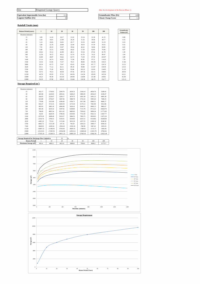
Site Ringstead Grange Quarry After the development of the Boxcut (Phase 1)
Equivalent Impermeable Area (ha) 11.5 Groundwater Flow (l/s) 0.09Lagoon Outflow (l/s) 32 Climate Change Factor 1.1
Rainfall Totals (mm)
Return Period (years) 1 10 20 30 50 100 200Groundwater
Volume (m3)
Duration (minutes) 15 3.09 14.10 18.17 21.02 25.24 32.28 41.25 0.0830 4.28 18.01 22.90 26.29 31.26 39.46 49.77 0.1645 5.14 20.65 26.05 29.77 35.19 44.09 55.19 0.2460 5.84 22.70 28.48 32.44 38.19 47.59 59.25 0.32
120 7.91 28.33 35.07 39.64 46.22 56.84 69.85 0.65180 9.40 32.15 39.48 44.42 51.50 62.85 76.66 0.97240 10.62 35.12 42.89 48.11 55.54 67.42 81.78 1.30360 12.59 39.72 48.12 53.74 61.70 74.32 89.47 1.94720 16.80 48.87 58.42 64.73 73.59 87.50 103.97 3.89
1440 21.14 56.74 66.92 73.58 82.85 97.22 114.03 7.782160 24.16 61.85 72.37 79.21 88.69 103.29 120.22 11.662880 26.54 65.72 76.47 83.43 93.04 107.77 124.76 15.554320 30.11 71.12 82.11 89.18 98.88 113.67 130.59 23.335760 32.92 75.20 86.33 93.46 103.22 118.01 134.85 31.107500 35.72 79.13 90.38 97.56 107.34 122.11 138.85 40.50
11520 40.78 85.93 97.33 104.56 114.36 129.05 145.56 62.2115000 44.23 90.38 101.85 109.09 118.88 133.48 149.81 81.0022800 50.29 97.90 109.42 116.66 126.38 140.79 156.77 123.12
Storage Required (m3)
Duration (minutes)15 362.17 1754.93 2269.79 2630.31 3164.14 4054.70 5189.4130 483.98 2220.83 2839.41 3268.25 3896.95 4934.25 6238.4745 564.05 2526.07 3209.17 3679.75 4365.38 5491.23 6895.3860 623.88 2756.67 3487.84 3988.78 4716.16 5905.26 7380.25
120 770.86 3353.99 4206.60 4784.71 5617.08 6960.51 8606.27180 844.47 3722.35 4649.59 5274.50 6170.12 7605.90 9352.86240 883.93 3983.18 4966.08 5626.41 6566.31 8069.13 9885.67360 903.38 4335.32 5397.92 6108.85 7115.79 8712.22 10628.70720 746.69 4803.54 6011.62 6809.83 7930.62 9690.24 11773.69
1440 -82.81 4420.59 5708.36 6550.85 7723.50 9541.31 11667.772160 -1079.30 3688.49 5019.27 5884.53 7083.75 8930.65 11072.292880 -2156.74 2799.53 4159.41 5039.85 6255.51 8118.86 10268.094320 -4462.16 725.61 2115.84 3010.20 4237.25 6108.18 8248.565760 -6863.72 -1515.30 -107.35 794.59 2029.23 3900.17 6030.437500 -9840.92 -4349.56 -2926.43 -2018.16 -780.99 1087.42 3205.03
11520 -16897.52 -11186.05 -9743.95 -8829.35 -7589.65 -5731.37 -3642.8515000 -23123.91 -17285.93 -15834.98 -14919.12 -13680.68 -11833.78 -9768.0422800 -37291.20 -31268.53 -29811.25 -28895.39 -27665.81 -25842.95 -23821.48
Storage Required for Discharge Flow Limited to 32 l/sReturn Period 1 10 20 30 50 100 200
Maximum Storage (m3) 903.4 4803.5 6011.6 6809.8 7930.6 9690.2 11773.7
-5000
-3000
-1000
1000
3000
5000
7000
9000
11000
0 200 400 600 800 1000 1200 1400
Sto
rage
(m
3 )
Duration (minutes)
1 Year
10 Years
20 Years
30 Years
50 Years
100 Years
0
2000
4000
6000
8000
10000
12000
0 10 20 30 40 50 60 70 80 90 100
Sto
rage
(m
3 )
Return Period (Years)
Storage Requirement

Site Ringstead Grange Quarry Around Phase 5
Equivalent Impermeable Area (ha) 10.9 Groundwater Flow (l/s) 0.29Lagoon Outflow (l/s) 32 Climate Change Factor 1.1
Rainfall Totals (mm)
Return Period (years) 1 10 20 30 50 100 200Groundwater
Volume (m3)
Duration (minutes) 15 3.09 14.10 18.17 21.02 25.24 32.28 41.25 0.2630 4.28 18.01 22.90 26.29 31.26 39.46 49.77 0.5245 5.14 20.65 26.05 29.77 35.19 44.09 55.19 0.7860 5.84 22.70 28.48 32.44 38.19 47.59 59.25 1.04
120 7.91 28.33 35.07 39.64 46.22 56.84 69.85 2.09180 9.40 32.15 39.48 44.42 51.50 62.85 76.66 3.13240 10.62 35.12 42.89 48.11 55.54 67.42 81.78 4.18360 12.59 39.72 48.12 53.74 61.70 74.32 89.47 6.26720 16.80 48.87 58.42 64.73 73.59 87.50 103.97 12.53
1440 21.14 56.74 66.92 73.58 82.85 97.22 114.03 25.062160 24.16 61.85 72.37 79.21 88.69 103.29 120.22 37.582880 26.54 65.72 76.47 83.43 93.04 107.77 124.76 50.114320 30.11 71.12 82.11 89.18 98.88 113.67 130.59 75.175760 32.92 75.20 86.33 93.46 103.22 118.01 134.85 100.227500 35.72 79.13 90.38 97.56 107.34 122.11 138.85 130.50
11520 40.78 85.93 97.33 104.56 114.36 129.05 145.56 200.4515000 44.23 90.38 101.85 109.09 118.88 133.48 149.81 261.0022800 50.29 97.90 109.42 116.66 126.38 140.79 156.77 396.72
Storage Required (m3)
Duration (minutes)15 341.95 1662.05 2150.04 2491.76 2997.74 3841.83 4917.3430 456.09 2102.32 2688.63 3095.09 3691.00 4674.18 5910.3545 530.67 2390.32 3037.78 3483.81 4133.66 5200.77 6531.6660 586.06 2607.57 3300.60 3775.40 4464.83 5591.89 6989.92
120 720.10 3168.46 3976.58 4524.52 5313.47 6586.80 8146.70180 784.59 3512.32 4391.18 4983.49 5832.38 7193.25 8849.07240 816.71 3754.26 4685.89 5311.77 6202.62 7627.03 9348.80360 824.61 4077.49 5084.65 5758.49 6712.89 8226.03 10042.52720 644.45 4489.64 5634.69 6391.26 7453.57 9121.38 11096.13
1440 -205.06 4063.38 5283.96 6082.50 7193.97 8916.93 10932.452160 -1212.83 3306.20 4567.55 5387.66 6524.32 8274.86 10304.762880 -2297.34 2400.34 3689.27 4523.77 5676.01 7442.14 9479.244320 -4609.04 308.06 1625.76 2473.45 3636.48 5409.80 7438.515760 -7011.87 -1942.50 -608.01 246.88 1417.10 3190.42 5209.547500 -9986.67 -4781.81 -3432.94 -2572.06 -1399.43 371.49 2378.62
11520 -17028.43 -11614.95 -10248.09 -9381.21 -8206.19 -6444.86 -4465.3115000 -23235.82 -17702.44 -16327.19 -15459.11 -14285.29 -12534.75 -10576.7822800 -37349.51 -31641.07 -30259.82 -29391.75 -28226.32 -26498.56 -24582.56
Storage Required for Discharge Flow Limited to 32 l/sReturn Period 1 10 20 30 50 100 200
Maximum Storage (m3) 824.6 4489.6 5634.7 6391.3 7453.6 9121.4 11096.1
-5000
-3000
-1000
1000
3000
5000
7000
9000
11000
0 200 400 600 800 1000 1200 1400
Sto
rage
(m
3 )
Duration (minutes)
1 Year
10 Years
20 Years
30 Years
50 Years
100 Years
0
1000
2000
3000
4000
5000
6000
7000
8000
9000
10000
0 10 20 30 40 50 60 70 80 90 100
Sto
rage
(m
3 )
Return Period (Years)
Storage Requirement
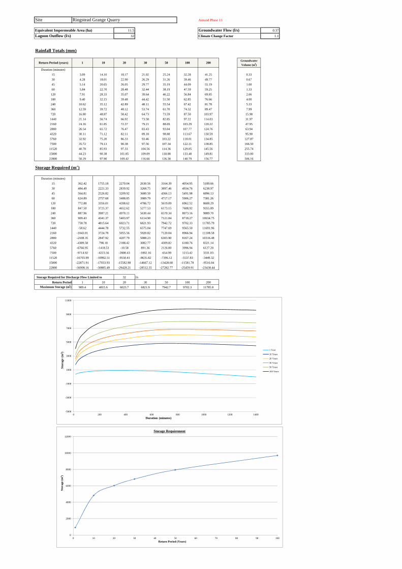
Site Ringstead Grange Quarry Around Phase 11
Equivalent Impermeable Area (ha) 11.5 Groundwater Flow (l/s) 0.37Lagoon Outflow (l/s) 32 Climate Change Factor 1.1
Rainfall Totals (mm)
Return Period (years) 1 10 20 30 50 100 200Groundwater
Volume (m3)
Duration (minutes) 15 3.09 14.10 18.17 21.02 25.24 32.28 41.25 0.3330 4.28 18.01 22.90 26.29 31.26 39.46 49.77 0.6745 5.14 20.65 26.05 29.77 35.19 44.09 55.19 1.0060 5.84 22.70 28.48 32.44 38.19 47.59 59.25 1.33
120 7.91 28.33 35.07 39.64 46.22 56.84 69.85 2.66180 9.40 32.15 39.48 44.42 51.50 62.85 76.66 4.00240 10.62 35.12 42.89 48.11 55.54 67.42 81.78 5.33360 12.59 39.72 48.12 53.74 61.70 74.32 89.47 7.99720 16.80 48.87 58.42 64.73 73.59 87.50 103.97 15.98
1440 21.14 56.74 66.92 73.58 82.85 97.22 114.03 31.972160 24.16 61.85 72.37 79.21 88.69 103.29 120.22 47.952880 26.54 65.72 76.47 83.43 93.04 107.77 124.76 63.944320 30.11 71.12 82.11 89.18 98.88 113.67 130.59 95.905760 32.92 75.20 86.33 93.46 103.22 118.01 134.85 127.877500 35.72 79.13 90.38 97.56 107.34 122.11 138.85 166.50
11520 40.78 85.93 97.33 104.56 114.36 129.05 145.56 255.7415000 44.23 90.38 101.85 109.09 118.88 133.48 149.81 333.0022800 50.29 97.90 109.42 116.66 126.38 140.79 156.77 506.16
Storage Required (m3)
Duration (minutes)15 362.42 1755.18 2270.04 2630.56 3164.39 4054.95 5189.6630 484.49 2221.33 2839.92 3268.75 3897.46 4934.76 6238.9745 564.81 2526.82 3209.92 3680.50 4366.13 5491.98 6896.1360 624.89 2757.68 3488.85 3989.79 4717.17 5906.27 7381.26
120 772.88 3356.01 4208.62 4786.72 5619.09 6962.52 8608.29180 847.50 3725.37 4652.62 5277.53 6173.15 7608.92 9355.89240 887.96 3987.21 4970.11 5630.44 6570.34 8073.16 9889.70360 909.43 4341.37 5403.97 6114.90 7121.84 8718.27 10634.75720 758.78 4815.64 6023.71 6821.93 7942.72 9702.33 11785.79
1440 -58.62 4444.78 5732.55 6575.04 7747.69 9565.50 11691.962160 -1043.01 3724.78 5055.56 5920.82 7120.04 8966.94 11108.582880 -2108.35 2847.92 4207.79 5088.23 6303.90 8167.24 10316.484320 -4389.58 798.18 2188.42 3082.77 4309.82 6180.76 8321.145760 -6766.95 -1418.53 -10.58 891.36 2126.00 3996.94 6127.207500 -9714.92 -4223.56 -2800.43 -1892.16 -654.99 1213.42 3331.03
11520 -16703.99 -10992.51 -9550.41 -8635.82 -7396.12 -5537.83 -3449.3215000 -22871.91 -17033.93 -15582.98 -14667.12 -13428.68 -11581.78 -9516.0422800 -36908.16 -30885.49 -29428.21 -28512.35 -27282.77 -25459.91 -23438.44
Storage Required for Discharge Flow Limited to 32 l/sReturn Period 1 10 20 30 50 100 200
Maximum Storage (m3) 909.4 4815.6 6023.7 6821.9 7942.7 9702.3 11785.8
-5000
-3000
-1000
1000
3000
5000
7000
9000
11000
0 200 400 600 800 1000 1200 1400
Sto
rage
(m
3 )
Duration (minutes)
1 Year
10 Years
20 Years
30 Years
50 Years
100 Years
0
2000
4000
6000
8000
10000
12000
0 10 20 30 40 50 60 70 80 90 100
Sto
rage
(m
3 )
Return Period (Years)
Storage Requirement

Site Ringstead Grange Quarry Around Phase 16
Equivalent Impermeable Area (ha) 12.8 Groundwater Flow (l/s) 1.13Lagoon Outflow (l/s) 32 Climate Change Factor 1.1
Rainfall Totals (mm)
Return Period (years) 1 10 20 30 50 100 200Groundwater
Volume (m3)
Duration (minutes) 15 3.09 14.10 18.17 21.02 25.24 32.28 41.25 1.0230 4.28 18.01 22.90 26.29 31.26 39.46 49.77 2.0345 5.14 20.65 26.05 29.77 35.19 44.09 55.19 3.0560 5.84 22.70 28.48 32.44 38.19 47.59 59.25 4.07
120 7.91 28.33 35.07 39.64 46.22 56.84 69.85 8.14180 9.40 32.15 39.48 44.42 51.50 62.85 76.66 12.20240 10.62 35.12 42.89 48.11 55.54 67.42 81.78 16.27360 12.59 39.72 48.12 53.74 61.70 74.32 89.47 24.41720 16.80 48.87 58.42 64.73 73.59 87.50 103.97 48.82
1440 21.14 56.74 66.92 73.58 82.85 97.22 114.03 97.632160 24.16 61.85 72.37 79.21 88.69 103.29 120.22 146.452880 26.54 65.72 76.47 83.43 93.04 107.77 124.76 195.264320 30.11 71.12 82.11 89.18 98.88 113.67 130.59 292.905760 32.92 75.20 86.33 93.46 103.22 118.01 134.85 390.537500 35.72 79.13 90.38 97.56 107.34 122.11 138.85 508.50
11520 40.78 85.93 97.33 104.56 114.36 129.05 145.56 781.0615000 44.23 90.38 101.85 109.09 118.88 133.48 149.81 1017.0022800 50.29 97.90 109.42 116.66 126.38 140.79 156.77 1545.84
Storage Required (m3)
Duration (minutes)15 407.29 1957.50 2530.55 2931.83 3526.01 4517.24 5780.2230 547.06 2480.24 3168.75 3646.07 4345.84 5500.40 6952.0545 640.36 2824.17 3584.49 4108.27 4871.40 6124.52 7687.4060 711.14 3085.03 3898.85 4456.42 5266.02 6589.54 8231.27
120 891.46 3766.60 4715.59 5359.05 6285.51 7780.81 9612.62180 990.12 4193.32 5225.39 5920.94 6917.80 8515.88 10460.33240 1050.77 4500.37 5594.38 6329.36 7375.50 9048.21 11070.10360 1105.88 4925.78 6108.50 6899.80 8020.57 9797.46 11930.58720 1031.86 5547.31 6891.95 7780.40 9027.89 10986.42 13305.39
1440 309.34 5321.82 6755.17 7692.90 8998.11 11021.41 13388.262160 -599.02 4707.73 6188.94 7152.02 8486.80 10542.48 12926.222880 -1597.50 3919.04 5432.64 6412.61 7765.70 9839.68 12231.874320 -3762.02 2012.19 3559.58 4555.04 5920.80 8003.23 10385.575760 -6033.54 -80.51 1486.59 2490.50 3864.70 5947.14 8318.217500 -8862.12 -2750.00 -1166.00 -155.05 1221.97 3301.59 5658.58
11520 -15595.52 -9238.40 -7633.28 -6615.30 -5235.46 -3167.10 -842.5015000 -21555.42 -15057.50 -13442.52 -12423.13 -11044.70 -8989.02 -6689.7522800 -35149.33 -28445.84 -26823.82 -25804.43 -24435.86 -22406.93 -20156.94
Storage Required for Discharge Flow Limited to 32 l/sReturn Period 1 10 20 30 50 100 200
Maximum Storage (m3) 1105.9 5547.3 6892.0 7780.4 9027.9 11021.4 13388.3
-5000
-3000
-1000
1000
3000
5000
7000
9000
11000
13000
0 200 400 600 800 1000 1200 1400
Sto
rage
(m
3 )
Duration (minutes)
1 Year
10 Years
20 Years
30 Years
50 Years
100 Years
0
2000
4000
6000
8000
10000
12000
0 10 20 30 40 50 60 70 80 90 100
Sto
rage
(m
3 )
Return Period (Years)
Storage Requirement