![Orator Rosa Puig[1][1]](https://static.fdocuments.us/doc/165x107/559e24af1a28aba1208b45bd/orator-rosa-puig11.jpg)
Miguel Ángel Puig González - CDEMA- Caribbean … · The Caribbean Risk Management ... mainly due...
35
Transcript of Miguel Ángel Puig González - CDEMA- Caribbean … · The Caribbean Risk Management ... mainly due...


Author
Miguel Ángel Puig González
Testimonials
Lianne García Vázquez
Collaborators
Pablo De Varona De Varona
Argelio Hernández Richelme
Herminia Serrano Méndez
Idalmis Saura Hernández
Georgina Michelena Álvarez
General coordination
Rosendo Mesías González
Edition review
Charo Guerra
Design
Yamil A. Díaz Pérez
Pictures and Photos
Roberto Moya Ortega
Pictures and Photos were taken from Cuba UNDP and national counterparts
Printing, publishing and design is done in the framework of the United Nations Development Programme (UNDP) with the support from the European Commission Humanitarian Aid Office and Civil Protection (ECHO): Strengthening the early warning system for hydro-meteorological events in the eastern provinces of Cuba.
The Caribbean Risk Management Initiative (CRMI) has also collaborated in the production of this material.
UNDP Cuba, 2014


2
5
6
8
8
25
26
29
31
INDEX
I. BACKGROUNDS
II. BEGINNING OF THE EXPERIENCE
III. STRENGTHENING COMPONENTS OF EARLY WARNING SYSTEMS
3.1. HYDRO-METEOROLOGICAL MONITORING AND MODELLING
3.2. RISK ASSESSMENT AND DECISION MAKING
3.3. PUBLIC MESSAGE DISSEMINATION
3.4. MEASURES OF PROTECTION
IV. FINAL REMARKS

3
FOREWORD
In the context of the last decade, where the negative impact of natural disasters has increased, Cuba has achieved a significant development of policies and practices for prevention, preparedness and response to emergencies and disasters caused by hydro-meteorological events. This effort has resulted from a combination of government policies and priorities and from the preparedness reached by the population, used to practice exercises for these purposes.
Endorsed in Hyogo Framework for Action, the assessment, identification and monitoring of disaster risk and the strengthening of early warning, have been also UNDP priorities, who, together with the Cuban government, has been working for over a decade in the field of disaster risk reduction.
After the wake of Hurricane Sandy in late 2012 through the eastern region of Cuba, it was approved, by the Action Plan for the Caribbean from the Disaster Preparedness Programme of the European Commission Humanitarian Aid and Civil Protection Department (DIPECHO), the project “Strengthening hydro-meteorological Early Warning Systems (EWS) in the eastern provinces of Cuba”. This initiative was implemented by the United Nations Development Programme (UNDP), with the participation of UN-Habitat.
The effectiveness of the Early Warning System in Cuba has been recognized by the World Meteorological Organization (WMO) as a good practice. Hence, the challenge was to improve it from the identification and solution of some existing weaknesses.
This project had an impact on the four phases of hydro-meteorological Early Warning Systems (EWS): monitoring; risk assessment and decision making; public warning and protection of people and economic assets.
The project strengthened monitoring equipment with advanced technologies, such as the acquisition of satellite receivers, automatic stations and wireless communication systems which were combined with the incorporation of more traditional experiences as Volunteer Observers of the hydrological network. In this case, it can be highlighted the capacity achieved by the Management Centres for Risk Reduction that after ten years of successful work on risk prevention as an instrument of government increase its role in monitoring, by placing in early warning points of low meteorological coverage portable stations, operated by volunteer observers.
The developed methodologies and others used in this project enable to address more effectively the process, and contribute to enhance the perception of risk to face disaster situations for reducing losses of people and economic resources.

4
Similarly, it is noteworthy key stakeholder articulation of the Early Warning System, described in a process that integrates meteorological and hydrological services with studies of hazard, vulnerability and risk for obtaining complete information of modelling risk scenarios with different probabilities of occurrence. Due to its impact, this procedure is analyzed by the Civil Defence to be included in the methodological guide for Disaster Risk Reduction; and it also involves the other components of the EWS.
This publication systematizes hydro-meteorological EWS elements that were strengthened with the implementation of this project, and the products generated. It contains project results and testimonials of people benefited directly, officers of the Provincial Meteorological Centres, Territorial Delegations of Hydraulic Resources, and Scientific Institutions responsible for developing studies on Hazard, Vulnerability and Risk. The experience of volunteer observers, who live in vulnerable communities, is also displayed through their visions and opinions on the impact the project has had in their work and lives.
In order to be valued as a methodology to other areas of the country and the regional community, in this spirit, we share this material, which is an opportunity for technological and methodological upgrading in the effort of reducing risks to ensure the welfare of the people.
Claudio Tomasi
Deputy Resident Representative
UNDP Cuba

5
Historically, natural disasters that have caused major economic and human damages and losses in Cuba are those related to extreme hydro-meteorological events. This situation, mainly due to the geographical conditions placed in an area susceptible to the action of tropical cyclones, is exacerbated because of the large vulnerability in central urban areas where the housing stock is highly deteriorated.
With the objective of mitigating, in a short term, disruptive impacts caused by hydro-meteorological events, concerted efforts, inter-agency mechanisms and social actions were required to allow acting (systematically) in different stages: before, during and after a threat of this nature.
The Early Warning System (EWS) offers the possibility of concertedly committing, systematizing and applying emergency actions that allow responding immediately to urgent needs to safeguard the economic resources, but above all the human life and health, and guaranteeing food, water supply, and temporary shelters for the population.
This has been a recurring theme in the last decades by the international community. The World Conference on Disaster Reduction, held in the Japanese city of Kobe in 2005, adopted the Hyogo Framework for Action until 2015, where it was raised the idea of : “developing early warning systems… whose warnings are timely and understandable to those at risk, including guidance on how to act upon warnings”
Early Warning Systems are associated with extreme hydro-meteorological phenomena and droughts, excluding from this concept earthquakes, technological accidents and other, which sudden nature makes them unpredictable.
EWSs, which have been gradually refined through the analysis of experiences accumulated during the response to these phenomena, have been selected by the World Meteorological Organization (WMO) as one of the world’s seven good practices in this theme. Its effectiveness depends on four basic elements that can ensure a timely protection when facing natural phenomena, which frequency and severity have grown by the increasingly effects of the impacts of climate change. These four elements are:
MONITORING SYSTEM. One or more articulated institutions assume permanent monitoring and processing of variables that will ensure providing authorities timely integrated forecasting, during the increase of hazards; supported by standardized operational procedures and protocols for the integration of the services.
RISK ASSESSMENT AND DECISION MAKING. When authorities receive the warning by the monitoring system, they assess the risk level of threatened people and properties and make the relevant decisions for appropriate protection.
I. BACKGROUNDS

6
DISSEMINATION OF PUBLIC MESSAGES. Decisions taking are transmitted to the organizations in charge of running them and people in risk through the mass media and other alternative means.
APPROPRIATE RESPONSE. The existence of plans guarantees the timely protection of persons and assets at risk, according to the level of risk. This also demands for organizations and persons with adequate preparation in implementing these actions, which should be included in plans for disaster reduction and adapted to the magnitude of the events that may affect the territory.
The impact of disaster events in recent years, increasingly in severity by the accelerating trend of global climate change, has proven that Early Warning Systems (EWS) are the most effective solution to mitigate damages, especially in places where risks have not been reduced to an acceptable level.
The proper functioning of the EWS in hydro-meteorological events in Cuba has been the main support of the effective protection of people during the impact of extreme events that have affected the country in recent years.
In a recent assessment of the EWS in the Caribbean region, WMO recommended improving the capabilities of monitoring and forecasting of meteorological and hydrological services, strengthening coordination of all stakeholders through standardized operational procedures, enhancing procedures for disseminating warning messages to the population at risk and increasing cooperation and preparedness of all actors.
These considerations, together with the analysis obtained in the framework of the Action Plan of the United Nations System to support the Government during the recovery of Hurricane Sandy, stated the need to revitalize the hydro-meteorological EWS in the eastern part of the country and confirmed the urge to overcome other technological limitations, in short, improving and generalizing EWS as an effective tool for protecting the country. To this end, it was approved by the Humanitarian Aid and Civil Protection Office of the European Commission (ECHO) the project “Strengthening Early Warning Systems for extreme hydro meteorological events in the eastern Cuban provinces”.
Implemented in the provinces Santiago de Cuba, Holguin, Granma and Las Tunas, this initiative was aimed at seeking the excellence of a successful system by identifying and solving existing gaps, far beyond the technological improvement, materially speaking, taking into account the equipment of the monitoring system.
II. BEGINNING OF THE EXPERIENCE

7
In order to achieve this comprehensive purpose, a process of consultation and assessment was developed in selected territories, which included workshops and participatory analysis with technicians of the institutions of the meteorological and hydrological systems, specialists of risk assessment groups, officials of organizations involved in the response, journalists of mass media, and managers of local governments at all levels.
During the exchanges, there was a consensus in the need of overcoming the insufficient coordination among institutions, mainly in hydro-meteorological monitoring and modeling. The following diagram illustrates the initial functional relationships of the entities participating in the EWS:
The diagram of MONITORING entails the meteorological and hydrological services that respond to the functions involved in its name. It has a network of stations and surface to ensure ongoing monitoring of hydro-meteorological events in the country. Despite the efforts in this direction, a proper integration of meteorological and hydrological services had not been achieved so that decision makers and population could receive a joint assessment to allow the adoption of more effective and timely actions during the approaching of a rainy event. Although meteorological forecast has been improved, the hydrological service in practice merely conveys the consequences of rainfall, with a small reference to future scenarios. Moreover, the information on hazards of disaster risk studies (HVR) made in all municipalities was not applicable either in assessing the impact of rainfall associated with the event.
In the diagram WARNING TO DECISION MAKERS, decision makers are represented by the Defense Councils who are in charge of leading the response to extreme hydro-meteorological events, although sometimes the actions are conducted by government structures. At the beginning of the project, decision makers received information nuanced mainly by meteorological estimations lacking of a comprehensive assessment, which has caused the

8
adoption of, on one side, oversized protective measures with unnecessary expenses that could be avoided and at the other end, and much more dangerous, precipitated actions.
PUBLIC WARNING frames the dissemination of public messages from monitoring authorities and institutions, through national and regional mass media, as well as through the use of alternative and direct means. The main weakness of this component was that the information received at all levels was the one developed at the national level.
Finally, under the diagram PROTECTION, it is comprised the structures that ensure the implementation of measures for the protection of threatened people and properties to the community level and even to scattered families. The response and recovery measures included in regional disaster reduction plans were very general and did not consider the severity and magnitude of each event, so it was necessary to develop proposals to resize these plans.
This assessment allowed elaborating the project intervention strategy based on the development of each of the four components of the EWS: Monitoring, Warning to Decision Makers to measure risk perception and Decision Making, Public Warning and Protection.
3.1. HYDRO-METEOROLOGICAL MONITORING AND MODELLING
Many experts consider this as the main component of any EWS in so far it is the eyes and ears for timely warning about the possible approach of a hazardous event. For this reason, the project increased the response capacity of meteorological and hydrological services through equipment strengthening and the development of tools.
Installation of Satellite receivers
A LRIT station was acquired. The station receives data directly from the geostationary meteorological satellite GOES and is accompanied by a processing software to generate appropriate products that meet the needs of meteorologists. This equipment allows updating the information from the area near Cuba every 15 minutes with a resolution of 4 km in the visible bands, infrared and water vapor, which makes it a valuable tool for monitoring hazardous meteorological phenomena. Other two stations were acquired: EumetSat and GeonetCast that use satellite TV technology for receiving products that complement the LRIT station.
III. STRENGTHENING COMPONENTS OF EARLY WARNING SYSTEMS (EWS)

These systems, as the basis of an infrastructure for transmitting meteorological products, have the following advantages in obtaining satellite images over the Internet:
• The information is obtained almost in real time (with a delay of up to 10 minutes and an update period of up to 15). It works with original numerical data which allow its processing for getting customized products.
• The quality and image resolution (4 km) and other data obtained in this way, are practically impossible to be gotten on the internet unless there is a high-bandwidth. The images are complemented by reports, warnings, monitoring of phenomena, behaviour analysis of variables, among many other products in binary formats, ascii, tables, graphs and maps.
In addition, a WiFi link between the receiving station and the Forecast Center of the Institute of Meteorology (INSMET) was established to ensure the information traffic. The acquisition of additional licenses to install processing software has been very significant, to be installed in provinces benefited by the project. These receptors provide images useful for monitoring extreme local events, the preparation of short-term forecasting, climate studies, among other benefits.
9
Three meteorological stations LRIT, EumetSat and GeonetCast located in the Institute of Meteorology

10
Post processed water vapour image
24-hour rain forecast
Development of numerical models
Experts of the Center of Atmospheric Physics of INSMET developed a system of short-term forecasting (24 hours) with four domains for modeling with resolutions of 27, 9, 3 and 1 km, by coupling different global and regional models such as models of numerical meteorological forecasting with data of surface stations, soundings, radar and meteorological satellites.

11
This tool, named SISπ, complements the reception of satellite data and strengthens the ability of the meteorological service to forecast during the monitoring of extreme meteorological phenomena. This product, which has been successfully validated during the impact of some events, is now available, although works to optimize the model continue and there are plans in an immediate future for adding new domains of highest resolution, evaluating various methods of data assimilation, incorporating other models for forecasting tropical cyclones and using data assimilation modules in real time.

12
Output of numeric model in the domains of 27 and 9 kilometers
Mobile workshop for the installation and maintenance of meteorological stations and measuring instrument network
The Cuban monitoring service consists of 68 meteorological stations in all provinces with equipment of various technologies which mostly have many years of operation, and demand unflagging attention for their repair and maintenance. Specialists of the Center of Instruments and Methods of Observation (CIMO) of INSMET have the function of performing the most complex works: installation, maintenance and repair of meteorological stations, as well as works related to sensors, device connectivity for registering systematic measurements, the optical fiber connection or the installation of new equipment, among other activities. However CIMO specialists have faced difficulties in recent years to maintain the operation of the network of stations, mainly due to the lack of adequate transportation so that they can move to the stations, many located in inaccessible places, and by the lack of the right tools to undertake these jobs. For these reasons, a means of transport was acquired in the framework of the project, with adequate mechanical conditions which allow the secure transportation of specialists to any station of the network, even those hard to reach because of its location and condition of the roads.
The all-terrain vehicle was equipped with tools for mechanical work (drilling, welding, threads, cuts), electrical work (voltmeters, ammeters, oscilloscope) and for checking lines and communication equipments. This range of toolkits ensures installation of new equipment, checking quality parameters, maintenance and minor repairs. It is also equipped with laptops to ensure that specialists can make tests and software installation in the stations visited. Technicians of the Provincial Meteorological Centre, who perform less complex jobs, were provided with modulus of tools and supplies.
The acquisition and implementation of this mobile workshop meet the objective of increasing the capacity of Cuba in meteorological monitoring as it is already endowed by highly qualified human resources in developing software and hardware for the installation of meteorological and satellite stations, to provide a higher service quality to maintain the vitality of the network.

13
Some of the tools of the mobile workshop
Mobile workshop for installation, repair and maintenance of the network of meteorological stations
Automation of 15 meteorological stations
Every ten minutes these 15 automated meteorological stations issue results of the measurements of meteorological variables for the provincial meteorological centre and the national headquarters. Automation also includes the presence in each point of a personal computer network connected, with modern means of communications.
14
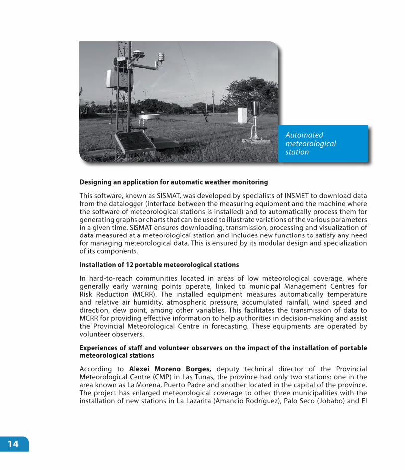
Automated meteorological station
Designing an application for automatic weather monitoring
This software, known as SISMAT, was developed by specialists of INSMET to download data from the datalogger (interface between the measuring equipment and the machine where the software of meteorological stations is installed) and to automatically process them for generating graphs or charts that can be used to illustrate variations of the various parameters in a given time. SISMAT ensures downloading, transmission, processing and visualization of data measured at a meteorological station and includes new functions to satisfy any need for managing meteorological data. This is ensured by its modular design and specialization of its components.
Installation of 12 portable meteorological stations
In hard-to-reach communities located in areas of low meteorological coverage, where generally early warning points operate, linked to municipal Management Centres for Risk Reduction (MCRR). The installed equipment measures automatically temperature and relative air humidity, atmospheric pressure, accumulated rainfall, wind speed and direction, dew point, among other variables. This facilitates the transmission of data to MCRR for providing effective information to help authorities in decision-making and assist the Provincial Meteorological Centre in forecasting. These equipments are operated by volunteer observers.
Experiences of staff and volunteer observers on the impact of the installation of portable meteorological stations
According to Alexei Moreno Borges, deputy technical director of the Provincial Meteorological Centre (CMP) in Las Tunas, the province had only two stations: one in the area known as La Morena, Puerto Padre and another located in the capital of the province. The project has enlarged meteorological coverage to other three municipalities with the installation of new stations in La Lazarita (Amancio Rodríguez), Palo Seco (Jobabo) and El

Andrés Roberto Palomo Guerra, a 51 year-old man from Holguin, lives in El Pesquero town, located in Cacocum municipality, he has in his house for three years an Early Warning Point, where a portable meteorological station was installed.
“We have here low-lying areas, liable to be flooded by heavy rains, and the EWP allows reducing the impact of any disaster. Through the equipment, we can communicate with the Direction Post set by the local government and with the Management Centre for Risk Reduction; and we then can perform quick actions before hazard events occur. It has been for us just right suit to a tee. Twice a day, I inform the Provincial Meteorological Centre of Holguin the situation of temperature, humidity, wind speed, but during the whole day, we are able to establish contact in any event or situation that could happen”
Silvia Maria Ramirez Ayarde has been working as a volunteer observer for a short time. She lives in Segundo Frente municipality in Santiago; she is 70 years old and only one year developing this function together with her husband. Both are in charge of an Early Warning Point in their town of Loma Blanca and consequently, they should record a greater number of meteorological variables.
“We have the task of reporting the amount of rainfall and temperature values, among other data measured by the meteorological station recently installed in our house as part of DIPECHO-UNDP project. We record this information and hand it over to the specialists of the Meteorological Center”. “To develop this work, my husband received training when specialists came to install the equipment. They explained how it worked, how does rain amount was marked, the speed and wind direction, pressure hectopascals; in short, a series of important information about the weather. These data are recorded in the console 24 hours a day. The function of the Early Warning Point is very significant: can you imagine that a storm may occur, and we can report exactly the time and how and what happened? Furthermore, the information we provide also serves to prevent any situation or disaster that may occur in the future”.
15
Canal (Jesús Menéndez), which can be maintained functioning 24 hours a day and can be moved to another area if necessary, furthermore they can record in a scheduled period of time a wide range of data required for meteorology work: wind speed and direction, pressure, temperature, among other.
Marcelo Cid Zayas, Head of PMC in Granma province brings elements that validate the relevance of the project DIPECHO-UNDP in Granma and in the entire eastern region.
“Through the project, three portable hydro meteorological stations were mounted in key points of the province, valuable tools for detecting and recording the main meteorological variables and the elements of an extreme event. These points are located in places where no data were obtained up to now. For example, one of these stations was installed in Pilón radar, and it was linked up with the same radar system, thus, it is already part of the provincial hydro meteorological system, in a point where many meteorological events occur, and of which no data and reports on winds and rains were available before. The second station was mounted in Cauto Cristo area, and the third one in Las Mercedes, with the peculiarity that it provides data of the mountain. Las Mercedes is a station of the Seismological Service, and, harnessing our people’s technical strength, it was placed there and now, data on meteorological variables of Sierra Maestra have been provided (within the time we have established). All this information is linked to the meteorological system and is presented to the Civil Defense, the Government and

16
Installation of 10 automatic hydrological stations in Cauto River basin
10 automatic hydrological stations were installed in Cauto River basin, which transmit real time data on rainfall and water flow. The hydrological control is a prerequisite for modeling the impact and extent of flooding caused by rains.
Experiences of staff and volunteer observers on the impact of the installation of automatic hydrological stations
The engineer Henny Corrales Sánchez acts as the senior specialist of the Centre for Hydrological Control in Granma Provincial, located in Bayamo city. From this centre, all hydraulic infrastructure of Granma region is controlled and recorded, and the behavior of each hydrological variables are monitored: level of the river, dams, rainfall and other works managed by the company. The new equipment installed there has enabled improving the benefits and allowing a more comprehensive and efficient work.
“The delegation of the National Institute of Hydraulic Resources (INRH) in our province has a monitoring system to all basins and hydro-meteorological variables associated to hydraulic works and areas vulnerable to flooding, in case of intense rains. The new equipment allows us to know in real time the behaviour of these variables: rainfall and river level. From these data, we can calculate the likely dam-flow in the main basins of the province. “Two new monitoring points were installed in our territory, which provide, together with thirteen we already have in Cauto basin, more complete information. This information is received and managed immediately to the direction post through the new equipment”. “But, at the same time, we are still using the conventional system of volunteer observers. Thanks to this, we have a greater amount of information in real time that complements the whole monitoring system through the equipment of the different points, and strengthens the accurate level in making decisions, especially when we are facing a hydro-meteorological event.”
To the technological improvement, the important role of volunteer observers is added, as Zoila Fernandez Fonseca, who lives in Loma Blanca area, in Segundo Frente municipality in Santiago de Cuba. She is not a specialist of the National Institute of Hydraulic Resources; however, she plays a key role in the Hydro-meteorological Early Warning System of the
Zoila Fernandez Fonseca, volunteer observer in the automatic hydrological station of Loma Blanca, Segundo frente, Santiago de Cuba

17
Cuban eastern region. She rigorously complies whit her role of volunteer observer, without receiving any financial benefit. “My role is to inform the amount of rainfall, in normal weather and during hurricanes. Before, I communicated only with Mayarí, now I do directly to Santiago de Cuba, with the Delegation of Hydraulic Resources; until recently, by telephone, but since June, 2014, a transmission radio station was fitted out to this purpose”. This station was one of the benefits of DIPECHO-UNDP project.
The young Leodannis Ortiz León lives in Salvador Rosales People´s Council, also in Santiago de Cuba province. He is depositary of a tradition that prolongs for over three decades.
“This work started with my grandmother. I was a kid and saw how she did it, and I learned. When she got older and stopped doing the job, I assumed the task. I have been developing it for over five years. My role is to keep abreast of the rain, every day, whether it rains or not. If it rains, I go out and measure the water, before eight o’clock. I record the figure in the book and then I communicate by the radio plant installed, as a contribution of DIPECHO-UNDP project. With the data volunteer observers provide to hydraulic resources network, calculations can be made, and thus knowing the amount of rainfall in each municipality, in each place of Cuba. And that can also help to prevent any situation or disaster, and help other people”.
Improvements in communications
Communication was one of the systems most affected by Hurricane Sandy in 2012, which limited the proper functioning of EWS in the eastern Cuban region. For this reason, one of the aims of the project was to strengthen communications for supporting the exchange of information between monitoring and forecasting institutions and decision-makers.
The communication system was strengthened through the installation and commissioning of new communication channels and by improving existing ones. A wireless link was set between the Centre for Reception of Satellite Products and the National Forecast Centre as an alternative pathway to ensure information traffic in case of failure of the primary channel. Wireless equipments were acquired: RLAN that were placed nationwide in INSMET, INRH and Cuban Institute of Radio and Television (ICRT). At the provincial level, they were installed in the PMC, provincial delegations of hydraulic resources, MCRR, provincial TV-centres, management posts of the Provincial Defence Council and Meteorological Stations in the capitals of the four provinces.
Other wireless equipments were: 20 VHF, placed in the hydro-meteorological network and 15 GPRS modem, placed in the 15 stations of the national network of the beneficiary provinces. Moreover, the Optical Fiber was acquired, connecting the datalogger with computers that receive meteorological data, ensuring greater reliability in transmitting information among these two points during the occurrence of extreme meteorological events.
The relevance of these communication systems is highlighted by Edgar Quintana Valdés, graduated in Physics and Master in Meteorological Sciences; and senior specialist of the Group of Instruments and Observation Methods of the CMP, with fifteen-year of experience in that work.

18
“Through the Project, the communication system improved considerably. This has had a positive effect on the work of the entire Early Warning System; and in particular in the connection with two stations we had virtually isolated until now (Veguita and Jucarito), which lacked a data transmission line. However, with the GPRS system being mounted to transmit data, we can get higher-quality, accurate and timely information. It is a definite advantage”.
Platform for information exchange between EWS institutions and entities
Platform for information exchange is a set of software tools for managing the entire flow of information from the EWS. This software includes modules for receiving and storing data, controlling and transmitting data, and for presenting specialized products.
The substantive architecture of this tool was defined based on the recommendations of the workshops with national and territorial bodies, and on the experiences from the response to events that have affected the country in recent years.
The technological platform design meets the following general requirements:
• Public information is available to all users. The access to the rest of the data is controlled by a security protocol according to the role of each entity.
• The operation is based on a format that is easy and enlightening for all users, even those who only have basic computer skills.
• The updating of data and information is done easily and in a short time
• Security protocols ensure that information can be only manipulated when updating by users that generate it and prevent tampering or theft by persons outside the system.
• The design of the platform ensures operation in other provinces that have not been benefited by the project.
Improvement of living conditions in provincial meteorological centres and meteorological stations
In addition to the updates of equipment and means for monitoring and hydro-meteorological forecasting, it was also took into account the conditions of the people who stay at stations during the wake of extreme hydro meteorological events. Therefore, they were endowed with materials to improve working conditions during the response to extreme events, ensuring the permanence of these men and women in those stations and a more effective performance during these situations.
Studies on Hazard Vulnerability and Risk (EPVR) in 15 meteorological stations
These studies not only strengthened monitoring but also the other components. The Group for risk assessment of the Environment Agency (AMA) developed risk studies in 15 meteorological facilities, considering the provincial centres and the stations that allowed identifying existing vulnerabilities, and, in turn, proposing the implementation of constructive actions to reduce risks to the impact of hazardous hydro-meteorological events.
19
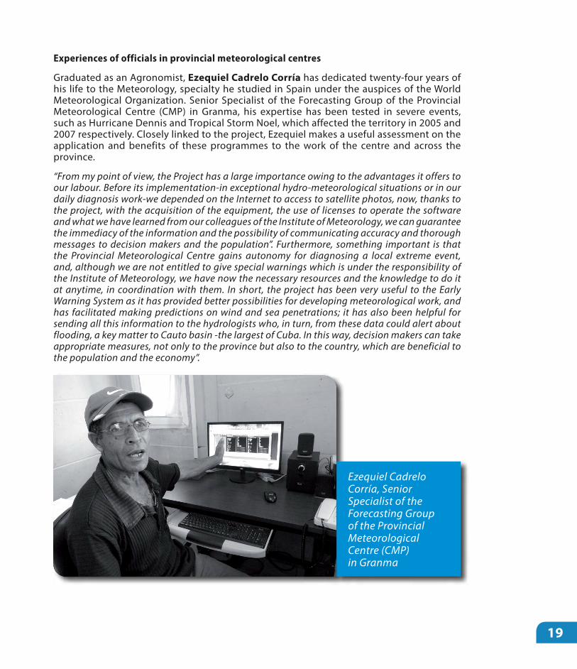
Experiences of officials in provincial meteorological centres
Graduated as an Agronomist, Ezequiel Cadrelo Corría has dedicated twenty-four years of his life to the Meteorology, specialty he studied in Spain under the auspices of the World Meteorological Organization. Senior Specialist of the Forecasting Group of the Provincial Meteorological Centre (CMP) in Granma, his expertise has been tested in severe events, such as Hurricane Dennis and Tropical Storm Noel, which affected the territory in 2005 and 2007 respectively. Closely linked to the project, Ezequiel makes a useful assessment on the application and benefits of these programmes to the work of the centre and across the province.
“From my point of view, the Project has a large importance owing to the advantages it offers to our labour. Before its implementation-in exceptional hydro-meteorological situations or in our daily diagnosis work-we depended on the Internet to access to satellite photos, now, thanks to the project, with the acquisition of the equipment, the use of licenses to operate the software and what we have learned from our colleagues of the Institute of Meteorology, we can guarantee the immediacy of the information and the possibility of communicating accuracy and thorough messages to decision makers and the population”. Furthermore, something important is that the Provincial Meteorological Centre gains autonomy for diagnosing a local extreme event, and, although we are not entitled to give special warnings which is under the responsibility of the Institute of Meteorology, we have now the necessary resources and the knowledge to do it at anytime, in coordination with them. In short, the project has been very useful to the Early Warning System as it has provided better possibilities for developing meteorological work, and has facilitated making predictions on wind and sea penetrations; it has also been helpful for sending all this information to the hydrologists who, in turn, from these data could alert about flooding, a key matter to Cauto basin -the largest of Cuba. In this way, decision makers can take appropriate measures, not only to the province but also to the country, which are beneficial to the population and the economy”.
Ezequiel Cadrelo Corría, Senior Specialist of the Forecasting Group of the Provincial Meteorological Centre (CMP) in Granma

20
Damara Calzadilla Meriño, geographer, who has run the PMC in Holguin for five years, said that
“with this project, our centre has gained numerous benefits. Above all, it allows improving meteorological monitoring twenty-four hours a day, the main role of our institution. This has been possible with the introduction of new equipment and the access to different levels of the monitoring system, which not only result in the development of a more efficient work in Holguin province, but also that the information obtained could become an important tool for authorities and decision-makers of the territory. For example, in communications and automation of meteorological stations, the project solves a historical problem we had in Holguin, the transmission of information. The automation of our six stations allows transmitting information in real time, something that has been limited so far by the lack of technology. Furthermore, the project provides new services to the forecasting group, including, the permanent availability of satellite images, which strengthens our work system, and the forecasts that are daily prepared in the centre”.
Damara`s words are stressed by Ernesto Chang Bermúdez, senior specialist of the forecasting group of PMC in Holguin, who has over twenty years of professional experience and to whom the project is invaluable, in particular, regarding his work.
“Satellite receptors in real time are a very important tool for allowing the emission of accurate and specialized forecasts in extreme meteorological events, and they are essential to our daily work. This is one of the main issues: the computing platform installed will be working with real time data, and will be permanently connected to the Early Warning Points, in this way we receive a very valuable information for our systematic meteorological monitoring work”.
The engineer Rodolfo del Toro Almenares, instead, prefers to talk about the benefits the project has for meteorological work, not only at central level but in the different branches of the PMC in Holguin. As head of the attention group to station networks in the province,
“He considers significant “having received a group of resources for improving workers’ conditions in our meteorological station. They are the unsung heroes of meteorological work. People do not speak too much about them and however, they are daily in charge of collecting information which is then used to elaborate forecasts, and provide the essential information to the province. But now, thanks to the project, comfort and working conditions have been improved, and workers have been endowed with an emergency module to better fulfill their tasks”.
Marcelo Cid Zayas, Head of CMP in Granma province and who, in turn, runs the Provincial Hydro-meteorological Group that forms part of the monitoring systems of the delegations of Hydraulic Resources and Civil Aviation and of the Meteorological Service. Cid Zaya agrees with the senior specialist of the Forecasting Group but he also provides elements that validate the relevance of DIPECHO-UNDP project in Granma province and throughout the eastern Cuban region.
Through the project, three portable hydro meteorological stations were mounted in key points of the province, valuable tools for detecting and recording the main meteorological variables and the elements of an extreme event. These points are located in places where

21
no data were obtained up to now. For example, one of these stations was installed in Pilón radar, and it was linked up with the same radar system, thus, it is already part of the provincial hydro meteorological system, in a point where many meteorological events occur, and of which no data and reports on winds and rains were available before. The second station was mounted in Cauto Cristo area, and the third one in Las Mercedes, with the peculiarity that it provides data of the mountain. Las Mercedes is a station of the Seismological Service, and, harnessing our people’s technical strength, it was placed there and now, data on meteorological variables of Sierra Maestra have been provided (within the time we have established). All this information is linked to the meteorological system and is presented to the Civil Defense, the Government and to other entities, if necessary.
Institutionalisation of hydro-meteorological EWS: Strengthening articulations of key stakeholders
All these actions strengthen the capacities of meteorological and hydrological systems to monitor and forecast the behaviour of extreme hydro-meteorological events. However, it was not enough with these investments. Experiences indicated that a change in the paradigm was indispensable, which could potentially articulate more strongly the work of monitoring institutions: among meteorological and hydrological services to determine the actual risk (the probability of impact of the upcoming event) and combine this information with the potential danger of disaster risk studies that exist in provincial and municipal levels.
The project takes advantage of the strengths associated with the installed equipment and the methodological tools developed to increase organizational articulation and promote a more comprehensive hydro-meteorological monitoring and modelling. By strengthening horizontal interaction, integrated meteorological and hydrological information are generated, addressed, on one hand, to decision-makers and specialized institutions, and on the other, to the population, as it is illustrated In the following scheme:
Horizontal interaction of hydrological and meteorological information, and with the use of the results of risk studies

22
In the previous scheme, several aspects that change the paradigm of hydro-meteorological monitoring and modelling appear:
a) The meteorological service prepares a non-public information about the possible impact of the event being monitored, even with assessments that have uncertainties, which not only is intended for decision-makers, but also for hydrological service that takes these assessments as a starting point for their work.
b) The hydrological service, which was previously limited to report only significant levels of accumulated rain and the situation of dams, can now model, based on the information from the meteorological service and other data, the damages of possible flooding associated with rains, even before starting to rain. Obviously, while the event nears the country, information from both services becomes more accurate, and after it starts to affect the territory, measurements of rainfall, flow rates and other variables increase the reliability of the modelling.
c) Both services add, to their respective assessments on the real risks associated with the event that is being monitored, the information on the potential hazard provided by disaster risk studies of each territory, which enables the participation of HVR groups in EWS, which exist to municipal level. This aspect is added as something new.
These three elements are evidenced both in national institutions and in provincial level, thus meteorological centres, hydrological services and risk studies groups of provinces reach a major role as technical advisers to local authorities, which is one of the main contributions of the project. Scheme below illustrates the sequence of work of these monitoring institutions at the provincial level:

23
At the municipal level, decision-makers are also advised by specialists of the Municipal Group for Risk Assessment, the Civil Defence and the Management Centres for Risk Reduction, who adapted to the characteristics of the territory (to the level of people´s council) the information about the predicted impact of the event, in correspondence with the risk studies of the municipality and the experiences of the damages caused by previous events, as illustrated in the following Scheme:
Sequence of work of INSMET and the INRH, together with the group for HVR studies at provincial level
Adapting the information to the characteristics of the territory

24
These interactions, both vertical and horizontal, were expressed in a comprehensive operational procedure or methodology of work, considered as one of the main results of the project, where it is clearly stated the role of each member institution of the EWS, at all levels and the information flow established between them. Furthermore, it is also accurately defined data delivered and required by each institution, to fulfil its function. This procedure is currently being analyzed by the Civil Defence for being included in the methodological guide for DRR, and involves the other components of the EWS.
In this component the following results were obtained:
1. Operational Procedure allowing the work articulation of meteorological and hydrological services at national and provincial level with hazard information from disaster risk studies during the monitoring of extreme meteorological events as part of the EWS.
2. Proposal of basic content of meteorological and hydrological assessment at national and provincial levels, including hazard information of risk study used in each case.
Proposal of continuity actions
1. The INSMET and the INRH should include in the manuals of operational procedures of each institution, the basic content of meteorological and hydrological information respectively, to be developed both at national and provincial levels, from the proposals carried out by the project, as well as the information that both institutions must submit to the meteorological centres and the hydrological services in the provinces, to ensure working at this level.
2. The INRH must continue developing the application that al lows developing hydrological modelling at all levels.
3. The INSMET and the INRH should coordinate their efforts to determine the joint work facing extreme rainy events in a hydrographic basins area covering the territory of several provinces.
4. Continuing preparedness of technician of meteorological and hydrological service network in the operation of the acquired equipment and tools, developed in the project.

25
3.2. RISK ASSESSMENT AND DECISION MAKING
Meteorological and hydrological information are discussed in management posts of the Defence Councils at all levels, with the advice of specialists from the meteorological and hydrological services and from the group of HVR studies. The level of integration of potential and actual hazards, as well as the modelling of potential scenarios, facilitates the adoption of more articulated and timely decisions in situations that even had not before been faced, preventing surprises and spontaneous actions.
Integrated information of monitoring institutions illustrates decision-makers on the odds and severity of the impact of events in the territory, but they also need to know the places and sectors where major damages are expected, in accordance with the studies of HVR, mainly in the municipality. Therefore, decision makers should combine hazard information with risk information for taking the necessary and timely decisions. For this reason, it was defined how authorities should use risk information of HVR studies associated with the three effects of hydro-meteorological events: rains, storm surge and winds.
The project facilitated the dissemination of Studies on Hazard, Vulnerability and Risks (HVR) developed by specialists from the Environment Agency; with the edition of the leaflet “Methodology for determining disaster risks at local level”, which allows checking the expected scenarios with forecasting. In order to train specialists, local authorities, community leaders, civil defence and technicians from different countries on prevention as the core action in facing disasters, and to facilitate the introduction of research results related to hazards, vulnerabilities and risks developed by the eastern provinces, the project strengthened the Regional Centre of Training for disaster risk reduction, which enables training staff to face disaster risk and climate change in the east of the country. “The Training Centre in Holguin together with the academic program”, also edited by the project, form part of the products that have been strengthened and that will continue working successfully in managing risk reduction, which has been developing with countries in the region in the framework of the Initiative for Risk Management in the Caribbean (CRMI) as part of the South - South cooperation.
In connection with this result, Rolbert Reyes Pupo, coordinator of studies on hazards, vulnerabilities and risks in Holguin explains that this project has enabled receiving the equipment needed to his entity, to prepare a Training Centre for specialists of the eastern region, affected by Hurricane Sandy.
“Capacities for training people working in diagnosing hydro-meteorological events are expected to be created in the centre. The objective goal is training meteorologists, specialists in risk reduction, activists attending Early Warning Points, technicians who will handle the meteorological stations installed as part of the project, and thus, strengthening human resources. It is not about being only satisfied with the required equipment for hydro-meteorological monitoring, but also knowing the efficient way of using it, and with higher quality in the territory and in all the eastern region of the country. And that is something we must work together”.
26
3.3. PUBLIC MESSAGE DISSEMINATION. SOFTWARE FOR SUBMITTING DAILY METEOROLOGICAL FORECASTS
During the project, specialists of the Meteorological Centre in the province of Cienfuegos developed a software for submitting meteorological forecasts, emphasizing in warning messages in case of hazardous meteorological events. The MEtTV3 was installed in TV-centres of the 4 selected provinces and its main function is to display meteorological information for the public, in High Definition and fully compatible with digital television (technology being introduced in Cuba right now), but thanks to its modular design it is possible to express information on various topics. Developed on the latest technology of three-dimensional graphics, information is produced with a high degree of realism and definition; also the use of methodologies outlined in manuals of TV forecasting allows it to be very intuitive for the viewer. Furthermore, the tools developed also make possible to show any landscape geographically referenced only by previously inserting its data.
The risk studies do not yet permit estimating the possible effects on economy sectors, where major losses caused by meteorological events in recent years are concentrated. During the workshops and interactive meetings, it was established by consensus that, during the approach of these events, each sector, with the information available in the Management Centre for Risk Reduction, should update the persisting vulnerabilities so that subgroups in charge of economic and social sectors in the provincial and municipal defence councils could propose priority actions to protect the assets of the economy according to the level of exposure.
In this component, the main result was the procedure for using risk information from studies of HVR in the decision making process during the response to meteorological events.
Proposal of continuity actions
1. The National General Staff of the Civil Defence, (EMNDC) should coordinate training for directors and officers of the structures of defence councils for using information on hazard and risk in the decision making process during the response to extreme hydro-meteorological events, through the use of different forms of education available in the country.
2. Including this procedure in the methodological guide for disaster reduction carried out by the EMNDC.

27
Strengthening communication abilities of the EWS
The project strengthened the communicative abilities of TV-centres located in its region of action, with the aim of contributing to the dissemination of higher quality public messages. In the interactive meetings with journalists and other staff involved in communicating on hazards associated with events that threaten an area, the important role of mass media in disseminating public message of the Early Warning System in extreme meteorological events was confirmed.
Cloud images produced by MtTV3software for submitting meteorological forecasts
Elaine Báez Acosta praises in particular the installation of a new software for submitting daily meteorological forecasts on television. As specialist in forecasting of the Provincial Meteorological Centre (CMP) of Granma, and degree in Physics, with fourteen-years of professional experience, Elaine is one of the regular faces on weather information broadcasted by the provincial TV-centre CNC.
The software is very important to our work, consisting in disseminating weather forecasts through different mass media and especially on television that best spreads our messages. The software was created by CMP colleagues in Cienfuegos, whom installed it here and trained us to use it. Moreover, thanks to DIPECHO-UNDP project, we have now more satellite information and licenses to work with real time data, so we can insert satellite images in our presentation on TV. Before, preparing presentations took longer, but now with the support of the software we have more operational services as we can immediately connect with the television and provide higher quality information, both in content or from the formal point of view, we have now a better end-product.
The new software is described by the PMC in Holguín, Damara Calzadilla Meriño, as “the most visual product” among the improvements implemented by the project:
“This software for submitting meteorological forecasts on TV, is a very useful tool for us, because it has an advanced technology in terms of visualization and implementation of forecasting for public dissemination, which is very important for having a better-informed population. Its relevance is higher in cases of potential hydro-meteorological hazard events for our territory”.

28
However, there are limited experiences on the role of the media and other stakeholders involved in disseminating public messages of hydro-meteorological monitoring and of authorities during the approach of extreme meteorological events.
To the conundrum of why media have more experience in normal conditions and after the impact of an event rather than during the approach of the phenomena?, the answer was that messages disseminated by the national media during the approach of an extreme hydro-meteorological event, often have been those submitted by the INSMET and the EMNDC and these messages generally overshadow territorial information. That is, the information from local authorities and monitoring institutions has been very limited. This is therefore an important gap in this component: defining the content and timing of public information from authorities and monitoring institutions in provincial and municipality levels.
The project has influenced in improving that situation, not only by identifying the urge of local media for having a higher role during monitoring events that threaten the territory, but also in its important role of keeping people better informed on the progress, characteristics and severity of the possible effects of the phenomenon.
The workshop also claimed that the effectiveness of this process can be achieved by clear, understandable, illustrative, updated and timely messages that meet the interests of each level and that are disseminated through all available transmission channels.
It was also recognized that the radio is the most effective channel to mobilize people to the community level in any situation and that the emergency network of amateur radio is a proven strength for disseminating public messages to remote and inaccessible places.
The main result of the project in this component was the identification of gaps that limited the effectiveness in disseminating public messages during the response to extreme hydro-meteorological events.
The functions of the media in the EWS not only were defined, but also the strength that Cuba has due to the availability of TV channels, radio stations and newspapers in all levels of the political administrative division of the country with experience in responding to these events for over 50 years.
However, despite these recognized strengths, a workshop was held in the city of Santiago de Cuba on the role of mass media in the stages of preparedness and response to extreme meteorological events. The main objective of the meeting was to identify the main difficulties in disseminating public messages that allow developing proposals to increase the effectiveness of this important component of the EWS.
The meeting was attended by representatives of the provincial government organisms, TV channels, radio stations and national, provincial and local newspapers, the meteorological and hydrological services, the Civil Defence, the management centres for risk reduction, and the Cuban Federation of radio amateurs.
During the workshop, there was consensus that public information on disaster reduction has three well-defined stages: during the preparedness in normal situations, aimed at training people, during the approach of extreme events as part of the EWS and post-impact event in the rehabilitation phase. Usually, results linked to before and after are highlighted.

29
Community workshop for training people in high-risk areas and managers of local governments
3.4. MEASURES OF PROTECTION
In the framework of the project, a methodology that allows increasing the perception of risk was designed and four community workshops were held in the eastern provinces to train people in high-risk areas and managers of local governments in assimilating the major elements for strengthening hydro-meteorological EWS. The methodological approach followed enables a comprehensive systematization of procedures suggested by the Environmental Agency for updating studies on hazards, vulnerabilities and risks. The experience in community work carried out by UN Habitat in Cuba, with emphasis on the Local Agenda 21 had been seized as an opportunity for developing these workshops, where the interagency working UNDP - UN Habitat was revealed, and allowed complementing established procedures by the AMA for risk perception.
Proposal of continuity actions
1. Using the MetTV3 application developed by the PMC of Cienfuegos to make public hydro- meteorological information more illustrative and understandable.
2. Continuing training activities on disaster risk reduction to journalists and staff linked to public information, especially in information related to local disaster risk studies that increases risk perception of individuals during the response stage.
3. Coordinating actions that allow updating the Communication Programme for disaster reduction.

30
TV spot to increase the perception on the four components of hydro-meteorological Early Warning System in the population
During the implementation of the project and its opportunities for exchanging with authorities, both at national and provincial level, the relevance of using all products and results achieved, to assess the correspondence between disaster reduction plans (DRP) and EWS strengthening, was visualized.
In the analysis carried out with officials of the National General Staff of the Civil Defence and its territorial bodies, the following weaknesses that influence over the operation of these plans were detected:
• Non-existence of a mechanism that allows updating the risk at the municipal level; plans that must start from the existing level of risk are not updated and lose their practical value.
• Lengthy documents that reduce the functionality of these plans as a guideline during the response to these events.
• Few measures are related to the results of the monitoring institutions, and there are not actions to ensure the dissemination of messages nor the process of decision making based on risk information.
This assessment indicated that it was essential to start a process of improvement of disaster reduction plans, considering the following aspects:
A TV spot that informs about the four components of the hydro-meteorological Early Warning System was produced, with the aim of broadcasting it through all Cuban television channels, especially by TV- centres in the four provinces where the project was implemented. The spot will allow sharing project results among the population and managers of economic entities and will help to increase the perception of risk and hazard associated with hydro-meteorological extreme events.

31
• For ensuring a proper updating of the plan for disaster reduction and for fulfilling its role as a guiding document for risk management in the territorial level, it is necessary to design a procedure that allows specialists of the municipal groups of HVR studies updating periodically the level of risk to people’s council, from the actions that were implemented for its reduction.
• Considering, during planning of response actions under normal conditions, the characteristics of the most likely phenomena, which allow distinguishing between measures to tackle extreme events and those with less severe impacts.
• Continuing training people to promote a real perception of hazard and risk according to the level of exposure.
• Response actions of disaster reduction plans must consider the four components of the EWS, including a breakdown of concrete activities to ensure their implementation.
Proposal of continuity actions
1. Strengthening disaster reduction plan under the direction of EMNDC, based on the gaps identified during the project.
2. The guidelines and measures to be adopted for improving the DRP and the management of risk reduction will be experimentally verified in selected municipalities and the results obtained will be applied in other territories through a training process that will be designed.
The purpose of this publication is to document the whole process developed, to be used and updated by local stakeholders and governments of each territory in future actions for early warning, to ensure preventing and managing disaster risks.
The results achieved and the systematized products allowed strengthening all components of the hydro-meteorological EWS in the four provinces where the project was implemented; ensuring the availability of information to all stakeholders of the system and the integration of products, under the premises of the protection of people and economic assets.
IV. FINAL REMARKS
32
Equipment and material were acquired, and methodological tools and procedures for the management and information handling were developed. A qualitative leap forward was achieved with the newness of articulating actions between EWS key stakeholders at all levels; combining the assessment of the potential hazard with follow up variables that measure the monitoring institutions.
From the technological point of view, the project considered relevant the use of both forefront technologies (satellite receivers, automatic stations, wireless communication systems) and traditional ones (portable stations, experiences of volunteer observers).
The methodologies used in this project point towards how to deal more effectively the strengthening of EWS to hydro-meteorological events in hydrographical basins and other local environments.
Knowledge management for both national and local capacities has been strengthened; contributing to a better preparedness for facing disaster situations and reducing the risk of losses of human and economical resources.
It can be stated that the achievement of these results has widely contributed towards synergies between the United Nations Development Programme (UNDP) in Cuba and the national institutions and territorial bodies: INSMET and INRH together with the Group of risk assessment of AMA, the EMNDC and governments of the four provinces where the project was implemented.
ACRONYMS
AMA Environment Agency
CD CDN Headquarter of the National Defence Council
CDM Municipal Defence Council
CDN National Defence Council
CDP Provincial Defence Council
CGRR Management Centre for Risk Reduction
CIMO Centre of Instruments and Methods of Observation
CMP Provincial Meteorological Centre
CNP National Forecast Centre
DC Civil Defence
DIPECHO Disaster Preparedness Programme of the
European Commission Humanitarian Aid and Civil Protection
Department
ECHO European Commission Humanitarian Aid and Civil Protection Department
EPVR Studies on Hazard, Risks and Vulnerabilities
GT Working Groups
ICRT Cuban Institute of Radio and Television
INRH National Institute of Hydraulic Resources
INSMET Institute of Meteorology
OMM World Meteorological Organization
OT PIP Body of Political Work
OT Working Bodies
PAT Early Warning Point
PD RH Post of Direction of Hydraulic Resources
PNUD United Nations Development Programme
PRD Disaster Reduction Plan
PVR Hazard, Vulnerability and Risk
SAT Early Warning System
ZD Civil Defence ZoneEMNDC National General Staff of the Civil Defence

care ACTAF