
Methodology for Identification of Intermittent and ... perennial stream exhibits the typical...
43
North Carolina Division of Water Quality Methodology for Identification of Intermittent and Perennial Streams and Their Origins Version 4.11 Effective Date: September 1, 2010
Transcript of Methodology for Identification of Intermittent and ... perennial stream exhibits the typical...

North Carolina Division of Water Quality
Methodology for Identification of
Intermittent and Perennial Streams and Their Origins
Version 4.11
Effective Date: September 1, 2010

This document should be cited as:
NC Division of Water Quality. 2010. Methodology for Identification of Intermittent and Perennial
Streams and their Origins, Version 4.11. North Carolina Department of Environment and Natural Resources, Division of Water Quality. Raleigh, NC.
Further Information can be obtained from:
North Carolina Division of Water Quality Wetlands and Stormwater Branch
Program Development Unit 1650 Mail Service Center Raleigh, NC 27699-1650
(919) 733-1786
Copies of this document are available through the internet:
http://portal.ncdenr.org/web/wq/swp/ws/401/waterresources/streamdeterminations
Table of Contents
Introduction ................................................................................................................................................... 4
Purpose and Need ........................................................................................................................................ 4
Development and Implementation Process .................................................................................................. 6
History of the Stream Identification Manual and Forms ................................................................................ 6
Scientific Justification .................................................................................................................................... 7
Suggested Field Equipment .......................................................................................................................... 9
Basic rules for making stream determinations .............................................................................................. 9
Scoring ........................................................................................................................................................ 10
Sources of Variability .................................................................................................................................. 11
Ditches and Modified Natural Streams ....................................................................................................... 12
Field Form Indicators and Descriptions ...................................................................................................... 12
A. Geomorphic Indicators ........................................................................................................................ 12
1. Continuity of Channel Bed and Bank ................................................................................................. 12
2. Sinuosity of Channel Along Thalweg ................................................................................................. 13
3. In-channel structure: Riffle-Pool, Step-Pool, Ripple-Pool sequence ................................................ 14
4. Particle Size in Stream Substrate ...................................................................................................... 15
5. Active/Relict Floodplain ...................................................................................................................... 16
6. Depositional Bars or Benches ............................................................................................................ 17
7. Recent Alluvial Deposits .................................................................................................................... 18
8. Headcuts ............................................................................................................................................ 19
9. Grade Control ..................................................................................................................................... 20
10. Natural Valley ................................................................................................................................... 21
11. Second (or Greater) Order Channel ................................................................................................ 22
B. Hydrologic Indicators ........................................................................................................................... 22
12. Presence of Baseflow ...................................................................................................................... 22
13. Iron Oxidizing Bacteria ..................................................................................................................... 23
14. Leaf litter ........................................................................................................................................... 24
15. Sediment on Plants or Debris .......................................................................................................... 25
16. Organic Drift Lines ........................................................................................................................... 25
17. Soil-based Evidence of a Seasonal High Water Table .................................................................... 26
i
C. Biological Indicators ............................................................................................................................ 28
18. Fibrous Roots in Streambed ............................................................................................................ 28
19. Rooted Upland Plants in Streambed ................................................................................................ 29
20. Benthic Macroinvertebrates ............................................................................................................. 29
21. Aquatic Mollusks .............................................................................................................................. 30
22. Fish ................................................................................................................................................... 31
23. Crayfish ............................................................................................................................................ 31
24. Amphibians ....................................................................................................................................... 32
25. Algae ................................................................................................................................................ 33
26. Wetland Plants in Streambed ........................................................................................................... 34
Background ................................................................................................................................................. 35
Recent and on-going Investigations ............................................................................................................ 35
NC DWQ Policy for the Definition of Perennial Stream Origins .................................................................. 35
Special Provision for Coastal Plain Streams ............................................................................................... 37
History of the Guidance for the Determination of the Origin of Perennial Streams .................................... 37
NC DWQ Stream Identification Form Version 4.11 .................................................................................... 41
List of Figures
Figure 1: Streamflow sources ....................................................................................................................... 8
Figure 2: Illustration of perennial and intermittent surface flow intersecting groundwater.. .......................... 8
Figure 3: Stream sinuosity .......................................................................................................................... 13
Figure 4: Examples of stream sinuosity ...................................................................................................... 14
Figure 5: Riffle-pool and step-pool stream morphologies. .......................................................................... 14
Figure 6: Examples of sediment sizes in the substrate .............................................................................. 16
Figure 7: Illustration of abandoned floodplain relative to stream and active floodplain .............................. 17
Figure 8: Plan view of depositional bars in straight, braided and meandering streams ............................. 17
Figure 9: Bankfull bench and related stream features ................................................................................ 18
Figure 10: Recent alluvial deposits. ............................................................................................................ 19
Figure 11: Headcut formation...................................................................................................................... 19
Figure 12: Examples of headcuts ............................................................................................................... 20
Figure 13: Example of grade control in Umstead State Park, Wake County NC. ....................................... 21
Figure 14: Illustration of groundwater flow and hyporheic zone.. ............................................................... 23
Figure 15: Iron oxidizing bacteria. ............................................................................................................... 24
ii

iii
Figure 16: Example of soil features ............................................................................................................ 28
Figure 17: Benthic macroinvertebrates ....................................................................................................... 30
Figure 18: Fingernail claims ........................................................................................................................ 31
Figure 19: Salamander ................................................................................................................................ 33
Figure 20: Algae and moss ......................................................................................................................... 34
List of Tables
Table 1: Guide to scoring categories .......................................................................................................... 11
Table 2: Ephemeroptera, Plecoptera and Trichoptera (EPT) perennial stream indicator .......................... 36
Table 3: Additional indicators of perennial streams .................................................................................... 36
NC Division of Water Quality –Methodology for Identification of Intermittent and Perennial Streams and Their Origins v. 4.11
4
SECTION 1 – Stream Identification Methodology Introduction This stream identification methodology is intended to guide natural resource professionals in the identification of ephemeral, intermittent and perennial streams using geomorphic, hydrologic and biological stream features. This manual and accompanying field form can be used to identify points on the landscape that represent stream origins and to determine whether a stream is ephemeral, intermittent or perennial in reaches that are some distance downstream of an origin. The manual focuses on headwater streams and the characteristic features of low-order streams wherever they occur in a watershed. Section 1 provides the background and scientific justification for the methodology. Section 2 outlines the field method and use of the rating form. Section 3 provides details on additional procedures for determination of a perennial stream. Version 4.11 of the manual replaces Version 3.1 (February 28, 2005) and reflects five years of regulatory and academic experience gained since the version 3.1. Clarifications and edits were made in several areas throughout the document to provide additional background on the methodology and improve readability of the manual. Changes to the indicators in the methodology were made for clarification purposes only and do not affect the total scores for stream evaluations or the stream determination made by professionals using the methodology. Changes made to indicators and scoring on the stream form from version 3.1 to 4.11 can be found at http://portal.ncdenr.org/web/wq/swp/ws/401/waterresources/streamdeterminations on the DWQ website. Purpose and Need The Methodology for Identification of Intermittent and Perennial Streams and Their Origins and numerical rating system were developed in response to requests from the North Carolina regulated community for an objective method to identify ephemeral, intermittent and perennial streams. The need for a stream identification methodology resulted from implementation of the Neuse River Basin Riparian Buffer Rules mandating buffers on all intermittent and perennial streams in the basin. The methodology has since been implemented for other river basins in the state that have riparian buffer rules as well as for stream identification related to stream mitigation. The definitions of ephemeral, intermittent and perennial streams are part of the North Carolina Administrative Code (NCAC) and the methods are tailored to these regulatory definitions. Complete language for the rules can be found at: http://reports.oah.state.nc.us/ncac.asp?folderName=\Title%2015A%20-%20Environment%20and%20Natural%20Resources The regulatory definitions of streams and related terms are below. Citation of the appropriate section of the North Carolina Administrative Code (NCAC) is shown in parentheses following each definition.
‘Stream’ means a body of concentrated flowing water in a natural low area or natural channel on the land surface. [15A NCAC 02B .0233(2)(k)]
‘Channel’ means a natural water-carrying trough cut vertically into low areas of the land
surface by erosive action of concentrated flowing water or a ditch or canal excavated for the flow of water. [15A NCAC 02B .0233(2)(a)]

NC Division of Water Quality –Methodology for Identification of Intermittent and Perennial Streams and Their Origins v. 4.11
5
'Ditch or canal' means a man-made channel other than a modified natural stream constructed for drainage purposes that is typically dug through inter-stream divide areas. A ditch or canal may have flows that are perennial, intermittent, or ephemeral and may exhibit hydrological and biological characteristics similar to perennial or intermittent streams. [15A NCAC 02B .0233(2)(c)]
‘Ephemeral (stormwater) stream’ means a feature that carries only stormwater in direct
response to precipitation with water flowing only during and shortly after large precipitation events. An ephemeral stream may or may not have a well-defined channel, the aquatic bed is always above the water table, and stormwater runoff is the primary source of water. An ephemeral stream typically lacks the biological, hydrological, and physical characteristics commonly associated with the continuous or intermittent conveyance of water. [15A NCAC 02B .0233(2)(d)]
’Groundwaters’ means those waters occurring in the subsurface under saturated conditions.
[15A NCAC 02L .0102 (11)] ’Intermittent stream’ means a well-defined channel that contains water for only part of the
year, typically during winter and spring when the aquatic bed is below the water table. The flow may be heavily supplemented by stormwater runoff. An intermittent stream often lacks the biological and hydrological characteristics commonly associated with the conveyance of water. [15A NCAC 02B .0233(2)(g)]
'Modified natural stream' means an on-site channelization or relocation of a stream and
subsequent relocation of the intermittent or perennial flow as evidenced by topographic alterations in the immediate watershed. A modified natural stream must have the typical biological, hydrological, and physical characteristics commonly associated with the continuous conveyance of water. [15A NCAC 02B .0233(2)(h)]
’Perched water table’ means a saturated soil horizon or horizon subdivision, with a free
water surface periodically observed in a bore hole or shallow monitoring well, but generally above the normal water table, or may be identified by drainage mottles or redoximorphic features, and caused by a less permeable lower horizon. [15A NCAC 18A .1935 (34)]
’Perennial stream’ means a well-defined channel that contains water year round during a
year of normal rainfall with the aquatic bed located below the water table for most of the year. Groundwater is the primary source of water for a perennial stream, but it also carries stormwater runoff. A perennial stream exhibits the typical biological, hydrological, and physical characteristics commonly associated with the continuous conveyance of water. [15A NCAC 02B .0233(2)(i)]
’Seasonal High Water Table’ means the highest level that groundwater, at atmospheric
pressure, reaches in the soil in most years. The seasonal high water table is usually detected by the mottling of the soil that results from mineral leaching. [15A NCAC 02H .1002 (15).]
Note that the definition of an intermittent stream refers to a stream only containing water for part of the year (typically winter and spring). Therefore the term “water table” that was used in the intermittent stream definition refers to the seasonal high water table in the riparian zone soil adjacent to the stream.

NC Division of Water Quality –Methodology for Identification of Intermittent and Perennial Streams and Their Origins v. 4.11
6
Development and Implementation Process
A Stream Technical Advisory Committee (TAC) was established by the North Carolina Division of Water Quality (NC DWQ) in December 1998 to provide technical and scientific input related to the definitions of streams and waterbodies in the Neuse River Basin for use in applying the riparian buffer rules. The TAC created the narrative stream definitions above and evaluated and approved a stream identification methodology, developed by NC DWQ, that evaluates geomorphic, hydrologic and biological stream features to determine the origins of intermittent streams The system of scoring stream features and developing minimum total scores for stream identification were established based on the results from over 300 individual field trials conducted in the piedmont and coastal plain portions of the Neuse River Basin, North Carolina. Field testing conducted during May, June, July and August of 1998 and during December 1998 and January 1999 consistently supported a minimum total score of 19.0 to distinguish ephemeral streams from intermittent streams. Scores less than 19.0 indicate ephemeral streams, whereas scores 19.0 or greater provide sufficient evidence that at least an intermittent stream is present. A score of 30.0 or more points is one method that may be used to determine the presence of a perennial stream. Alternate procedures for perennial stream identification are documented in Section 3 – Guidance for the Determination of Perennial Streams. Since the adoption of the first version of the stream identification manual in 1999, improvements and clarifications have been made in subsequent versions based on scientific literature and investigation as well as on experience and recommendations from the natural resource community using the methodology. Prior to the implementation of a revised manual, the manual is submitted to a 60-day public review period. All comments and suggestions collected over the review period are considered and incorporated when applicable. Following final revisions, the final manual version is adopted with an effective date and made available for all users. To date, the NC DWQ Stream Identification Methodology has served as the basis for similar endeavors elsewhere across the country, e.g. Fairfax County, Virginia (http://www.fairfaxcounty.gov/dpwes/watersheds/ps_protocols.pdf ); the Athens-Clarke County, Georgia, Department of Transportation and Public Works (http://www.athensclarkecounty.com/documents/pdf/publicworks/stream_id_manual.pdf ); State of Oregon US Army Corps of Engineers (USACE); South Carolina Department of Health and Environmental Control, and Tennessee Department of Environment and Conservation.
History of the Stream Identification Manual and Forms Version 1.0 – Unpublished. The Stream Identification Method was originally developed to
correlate scores with the persistence of water. Low scores would indicate streams in the upper portions of watersheds (low order streams), and the highest scores would indicate major rivers (high order streams).
Version 2.0 – Effective January 19, 1999. The method was termed the NC Stream Classification
Method and was adopted as a result of HB 1257 (Stream Identification for Buffer Rules), 2001-2002 Session of the NC General Assembly. The Stream Technical Advisory Committee evaluated and revised Version 1.0 of the form and recommended the use of the modified form by the NC DWQ.

NC Division of Water Quality –Methodology for Identification of Intermittent and Perennial Streams and Their Origins v. 4.11
7
Version 3.0 – Added considerable amount of explanatory material and restructured the rating form. Version 3.0 was developed during the summer and fall of 2004, and issued for public comment September 21, 2004. Version 3.0 was used in the development of Version 3.1.
Version 3.1 – Effective February 28, 2005- Minor edits and corrections resulting from a test of
the Version 3.0 material during the Surface Water Identification Training and Certification (SWITC) Class; November 15-17, 2004 and December 8-9, 2004. Version 3.1 incorporated the “Guidance for the Determination of the Origin of Perennial Streams.”
Version 4.11 – Effective September 1, 2010. Edits, clarifications and corrections resulting from a
test of the Version 3.1 material during the Surface Water Identification Training and Certification (SWITC) Classes in 2006, 2007 and 2008. Title change from “Identification Methods for the Origins of Intermittent and Perennial Streams” to “Methodology for Identification of Intermittent and Perennial Streams and their Origins.”
Scientific Justification A stream can be described as flowing surface water in a channel resulting from five sources of water discharge to the stream from the adjacent landscape (Figure 1). Baseflow or normal low flow in a stream between rainfall events is provided by two of those sources, groundwater discharge into the channel and unsaturated drainage from the soil moisture zone above the water table to the groundwater zone. During and shortly after rainstorms, the increased flow in the channel known as stormflow is provided by direct channel precipitation, surface runoff as overland flow, and rapid unsaturated flow through the soil (interflow) directly to the stream or to the groundwater zone. Increased groundwater discharge also provides a contribution to stormflow. Streams may exhibit both stormflow and baseflow characteristics as they flow from their origins to their destinations. However, the seasonal or continual presence of baseflow defines a stream as intermittent or perennial, respectively. The North Carolina stream definitions do not require water to be flowing, but only prescribe that water be present to meet the definition of intermittent or perennial flow for regulatory purposes. Also, within the regulatory framework, an intermittent or perennial stream origin is defined as a specific location in a stream. However, in most cases, stream origins usually occur as transition zones in which the location and length of the zone is subject to fluctuations in groundwater levels and precipitation. Frequently, streams change from ephemeral to intermittent and intermittent to perennial along a gradient or continuum —sometimes with no single distinct point demarcating these transitions (Figure 2).

NC Division of Water Quality –Methodology for Identification of Intermittent and Perennial Streams and Their Origins v. 4.11
8
Figure 1: Streamflow sources (Ritter 2008)
Figure 2: Illustration of perennial and intermittent surface flow intersecting groundwater. Adapted from Winter et al. 1998 http://pubs.usgs.gov/circ/circ1139.
In North Carolina, some streams follow that pattern and transition from ephemeral to intermittent to perennial, but in many cases, they do not. The transition in flow duration varies by landscape and general trends can be observed by geologic province, i.e., mountains, piedmont and coastal plain (Russell, unpublished report, 2008a). The presence or absence of permanent stream flow defines the hydrologic, geomorphic and biological character of streams. Hence, stream systems can be characterized by interactions among hydrologic, geomorphic (physical) and biological processes. Similar to the downstream continuum of ephemeral to intermittent to perennial stream flow, physical and biological characteristics follow the same pattern in response to flow volume and duration. The term “flow duration” used in this manual refers collectively to ephemeral, intermittent and perennial flow as described as one of the five components of flow regime (Poff and Ward 1989; Richter et al. 1996; Walker et al. 1995). Variations in physical and biological characteristics along the length of a stream can help distinguish what source of water predominately contributes to flow. The

NC Division of Water Quality –Methodology for Identification of Intermittent and Perennial Streams and Their Origins v. 4.11
9
fundamental source of water for intermittent and perennial stream baseflow as defined in the North Carolina Administrative Code (NCAC) is groundwater resulting from the intersection of the water table with the streambed. This definition is consistent with those of several other federal and state government agencies as well as many academic organizations (Moore 2003; Jackson et al. 2005; Beaudry et al. 2006; U.S. Army Corps of Engineers 2007,Wilson 2003). As baseflow becomes more persistent in the downstream direction, stream discharge, both stormflow and baseflow, increases and stream characteristics related to geomorphic, hydrologic and biological processes are more readily observed. For example, stream bedforms, such as gravel bars and pool-riffle sequences, are much more defined in perennial streams than in intermittent streams due to increased sediment supply as well as transport and depositional processes. Furthermore, aquatic organisms respond to the availability of habitat formed and maintained by geomorphic and hydrologic processes and vary depending on the persistence of water and streamflow. Stream characteristics and commonly observable features resulting from geomorphic, hydrologic and biological processes are used in this stream identification methodology to produce a numeric score. Attributes serve as indicators that can be observed independently of each other, although they are not intended to independently determine stream flow duration. The total score of all indicators provides the means for stream determination. The score is then used to assign a stream type of “ephemeral”, “intermittent”, or “perennial” to the stream reach being evaluated. SECTION 2 - Stream Identification Field Method and Rating Form Suggested Field Equipment Aquatic net and shallow white pan – used to catch and examine benthic macroinvertebrates and
aquatic vertebrates. A small aquarium net and plastic container lid may suffice if carrying full-size equipment is not feasible.
Global Positioning System (GPS) – used to determine coordinates of the stream origin or of a
stream reach. Camera – used to photograph and document site features. Munsell Soil Color Charts (Munsell 2000) – used to determine the soil matrix chroma when
looking for soil-based evidence of a seasonal high-water table. Field Indicators of Hydric Soils of the United States (USDA 2010)– used to help determine the
presence of a high water table. Soil auger – used to extract soils. National List of Vascular Plant Species that Occur in Wetlands: 1996 National Summary (U.S.
FWS 1997) - used to determine the indicator status of plants found in and adjacent to the streambed.
Basic rules for making stream determinations:
Do not evaluate a stream within 48 hours of rainfall that results in surface runoff.

NC Division of Water Quality –Methodology for Identification of Intermittent and Perennial Streams and Their Origins v. 4.11
10
Generally, it takes about 48 hours for increased streamflow resulting from precipitation to attenuate. Delaying a stream determination following rainfall helps to eliminate visual bias associated with observing water in a stream that may not currently have baseflow. Also stormflow may obscure many of the channel features that need to be observed and evaluated.
Review information on stream to be evaluated.
Gather and review available information regarding the area and location of the stream. The use of U.S. Geological Survey (USGS) topographic maps, Natural Resources Conservation Service (NRCS) soil survey maps, geology maps and/or high resolution topographic data (e.g., LiDAR-based) or aerial photography may help provide information when conducting the field investigation. Other important data may include land use/land cover or current construction activity in the area. To assist in evaluating whether flow in the stream is typical, current streamflow at nearby gauges, recent rainfall compared to normal, and drought status information is useful.
Become familiar with the characteristics of headwaters streams in the region of interest. Beginning users of this manual and form should visit a variety of headwater streams, look for the geomorphic, hydrologic and biological features discussed here, and gain experience observing the magnitude and variability of these features. The field evaluator is strongly encouraged to attend the four-day stream identification methodology class, taught by the NC DWQ and/or NC State University, pass the written and field exams, and to have familiarity with geomorphic, hydrologic and biological characteristics in headwater streams.
Walk to the upstream extent of the feature when feasible.
Evaluating the degree of development of many of the Stream Identification Method indicators involves comparing the stream reach of interest to upstream portions of the stream. Headwater streams are often discontinuous with segments with very poorly developed channels where baseflow flows under the surface. Therefore, an apparent perennial or intermittent stream origin may not be the actual origin. Continue walking upstream towards the ridge top until you are certain that you have observed the entire drainageway to its origin.
Evaluate at least 100 ft of stream to determine average conditions.
Determinations must not be made by observing one location in a stream, but rather should be made by observing a reach of stream. Generally, at least one hundred feet (sometimes more) of channel should be walked to make observations. This initial examination allows the evaluator to examine and study the nature of the channel, noting the presence or absence of bedforms, dominant sediment size, dominant stream processes, and characteristics that indicate the predominant source of water (stormflow, baseflow, tributary discharge, and the presence of benthic macroinvertebrates and/or vegetation). These initial observations also aid in determining the magnitude (absent, weak, moderate or strong) of specific parameters.
Scoring Identification of stream flow duration is accomplished by evaluating 26 different attributes of the stream and assigning a numeric score to each attribute. A scoring sheet (included on the last page of this manual) is used to record the score for each attribute and determine the total numeric score for the stream under investigation. The sheet specifically requests information for Date, Project, Evaluator, Site, County, Other (Quad Name), and Latitude and Longitude. However any other pertinent observations should also be recorded on this sheet. These may

NC Division of Water Quality –Methodology for Identification of Intermittent and Perennial Streams and Their Origins v. 4.11
11
include the amount and date of the last recent rain, hydrologic unit codes, or evidence of stream modifications. The hardcopy or digital scoring form is an official record, so all pertinent observations should be recorded on the form. The total score is intended to reflect the persistence of water with higher scores indicating intermittent and perennial streams. A four–tiered, weighted scale used for evaluating and scoring each attribute addresses the variability of streams. The categories (and their accompanying numerical scores), “Absent”, “Weak”, “Moderate”, and “Strong” are applied to sets of geomorphic, hydrologic and biological attributes. The score given to an attribute reflects the evaluator’s judgment of the average degree of development of the attribute along a reach of the stream at least 100 ft long. These categories are intended to allow the evaluator flexibility in assessing variable features or attributes. The small increments in scoring between gradations help reduce the range in scores between different evaluators. The score ranges were developed in order to better assess the often gradual and variable transitions of streams from ephemeral to intermittent. Definitions of Absent, Weak, Moderate and Strong are provided in Table 1. These definitions are intended as guidelines and the evaluator must select the most appropriate category based upon experience and observations of the stream under review, its watershed, and physiographic region. “Moderate” scores are intended as an approximate qualitative midpoint between the two extremes of “Absent” and “Strong.” The remaining qualitative description of “Weak” represents gradations that will often be observed in the field.
Table 1: Guide to scoring categories
Category Description
Absent The character is not observed
Weak The character is present but you have to search intensely (i.e., ten or more minutes) to find and evaluate it
Moderate The character is present and observable with brief (i.e., one or two minutes) searching and evaluation
Strong The character is easily observable and quickly evaluated
Sources of Variability Sources of spatial variation among stream systems are due primarily to geology, soils, and land cover and their interactions with precipitation and climate. For example, riffles, steps and pools are in-channel structures that vary by woody debris inputs, sediment size and sediment transport rates. Cobble, gravel and boulders are more common in the mountains and roots and woody debris are more common in the coastal plain. Other examples of variability include the magnitude (height) of headcuts, stream gradient and sediment supply. Temporal variations in flow are related to seasonal changes in precipitation and evapotranspiration, as well as recent precipitation and snowmelt events. Because recent precipitation can have an effect on stream flow, and therefore can influence scoring, it is strongly recommended that field evaluations be conducted at least 48 hours after hydrology-altering events, when conditions would be considered “normal” or representative for the season.

NC Division of Water Quality –Methodology for Identification of Intermittent and Perennial Streams and Their Origins v. 4.11
12
However, please note that the identification method was designed with redundancy among the indicators to allow for reasonably accurate ratings even after a recent precipitation. Ditches and Modified Natural Streams In many parts of North Carolina it may be difficult to differentiate between an artificial feature (e.g. ditch or canal) and a natural stream that has been modified (e.g. straightened or relocated). There are a variety of techniques that can be employed to help make this distinction. The topographic lines depicted on a USGS topographic map may indicate a natural valley in which a natural stream could be present. Parallel topographic contour crenulations (V-shaped contour lines) with angles of 90o or less can be indicative of the presence of a stream. Features located outside of a natural crenulation (i.e. moving across a slope rather than perpendicular to it) may not be natural or, alternatively, may be a relocated stream. Additionally, NRCS county soil survey maps often show the presence of linear soil mapping units, which are indicative of alluvial deposits and the presence of a stream. If the feature in question is determined to be artificial, scoring is not necessary for buffer rule applications in North Carolina since those rules do not apply to ditches. The exception is the Randleman Watershed Buffer Rules (see rules). Field Form Indicators and Descriptions A. Geomorphic Indicators 1. Continuity of Channel Bed and Bank
Throughout the length of the reach, is the stream clearly defined by having a discernable bank and streambed? The bed of a stream is the channel bottom and the physical confine of the “normal” baseflow or low water flow. Streambanks are vertical or sloped areas rising from the bed of the channel and are the lateral constraints (channel margins) of flow during all stages but flood stage. Flooding occurs when a stream overflows its banks and partly or completely fills its floodplain. As a general rule, the bed is that part of the channel at or near "normal" flow, and the banks are that part above the water line. However, because discharge varies, this differentiation is subject to local interpretation. Usually the bed is clear of terrestrial vegetation, while the banks are subjected to water flow only during high stages, and therefore can support vegetation much of the time. This indicator will lessen and may diminish or become fragmented upstream as the stream becomes ephemeral.
Strong – The stream has a well developed channel with continuous bed and bank present throughout the length of the reach.
Moderate – The majority of the stream channel has a continuous bed and bank.
However, there are obvious interruptions. Weak – The majority of the stream channel has obvious interruptions in the continuity of
bed and bank. However, there is still some representation of the bed and bank sequence.
Absent –The stream has a very poorly developed channel in which little or no bed and
bank can be distinguished.

NC Division of Water Quality –Methodology for Identification of Intermittent and Perennial Streams and Their Origins v. 4.11
13
2. Sinuosity of Channel Along Thalweg
What is the extent of stream sinuosity throughout the reach being evaluated? Sinuosity is a measure of a stream’s “curviness.” Specifically, hydraulic sinuosity is the sinuosity related to the hydraulic factors of water behavior rather than the influence of topography (Mueller 1968). Sinuosity is measured as the total stream length measured along the stream thalweg (the deepest part of the channel or the low flow channel) divided by the straight line valley length (Figure 3) (Mueller 1968; FISRWG 1998). The higher the result, the greater the sinuosity (Figure 4). The sinuosity of a stream is one way the stream maintains a constant gradient along the channel. Typically, natural, undisturbed streams with steep gradients have low sinuosity, and streams with low gradients have high sinuosity. The size of the stream and its contributing watershed area (a surrogate for discharge) are related to the stream gradient and sinuosity: usually the larger the stream, or stream order, the higher the sinuosity (Stall and Fok 1968). Intermittent streams do not have constant flow year-round, and as a result may have a less sinuous channel than perennial streams. Sinuosity should be visually estimated or measured in the field, rather than from aerial photography.
Figure 3: Stream Sinuosity (FISRWIG 1998).
Strong – Ratio > 1.4. Stream has numerous bends, very few straight sections. Moderate – 1.2 < Ratio < 1.4. Stream has some bends with a few straight sections. Weak – 1.0 < Ratio < 1.2. Stream has very few bends and numerous straight sections. Absent – Ratio = 1.0. Stream is completely straight with no bends.

NC Division of Water Quality –Methodology for Identification of Intermittent and Perennial Streams and Their Origins v. 4.11
14
Figure 4: Sinuosity ratio as defined by Allen (1970) 3. In-channel structure: Riffle-Pool, Step-Pool, Ripple-Pool sequence
Is there a regular sequence of riffles and pools or other erosion/deposition structural features in the channel indicative of frequent high flows? At low flows, a riffle is a zone of turbulent, shallow flow (similar to a rapid in larger streams). The substrate in riffles consists of the coarser sediment sizes in the stream. A pool is a zone of tranquil, deep-water flow. Finer sediments may dominate the bed material in pools if a fine textured sediment supply exists. In steep (slope > 2-4%) mountain and piedmont streams, step-pool sequences are typically formed instead of riffle-pool sequences. A repeating sequence of riffle-pool (or riffle-run or ripple-pool in sand bed streams, or step-pool in higher gradient streams) is usually observed in perennial streams where the bed material is larger than coarse sand (Leopold 1994). Riffle-run sequences in low gradient streams, such as those in the coastal plain, are often created by in-channel wood such as roots and woody debris. Ripple-run sequences are often found in low gradient, hydraulically smooth streams where the bed consists of fine sand or silt (Gordon et al. 1994). When present, these bedform characteristics can be observed even in a dry stream bed by closely examining the local profile of the channel (Figure 5).
Figure 5: Riffle-pool and step-pool stream morphologies (Church 1992).

NC Division of Water Quality –Methodology for Identification of Intermittent and Perennial Streams and Their Origins v. 4.11
15
Strong – Stream has a frequent number of riffles followed by pools along the entire reach. There is an obvious transition between riffles and pools.
Moderate – Stream has less frequent number of riffles and pools. Distinguishing the
transition between riffles and pools is difficult. Weak – Stream has some structure but dominated by areas of pools or areas of riffles. Absent – No sequence is observed.
4. Particle Size of Stream Substrate
Has downcutting penetrated through the soil profile such that the distribution of sediment size in the stream substrate is relatively coarser than the adjacent floodplain or streamside area? Well developed streams that have eroded through the soil profile often have substrate materials dominated by larger sediment sizes, e.g., coarse sand, gravel and cobble, relative to floodplain sediments and adjacent soils (Table 2). Similar sediment sizes in the stream bed and the adjacent stream side area indicate that stream forming processes have not been consistent enough to cut into the soil profile and form an intermittent or perennial stream (Figure 6a). The bed in ephemeral channels is typically soil, have the same or similar soil texture as areas adjacent to the stream, and often have differentiated soil horizons. The bed of intermittent or perennial streams is often comprised of coarser sediment relative to the adjacent bank area or floodplain due to consistent stream-forming flows that have transported finer particles downstream as the channel has eroded downward (Figure 6b). The usefulness of this attribute may vary among physiographic provinces. For instance, in the coastal plain or Sand Hills, the differences in particle sizes between the channel substrates and the channel bank/riparian zone soils are often less than in the piedmont and mountains.
Strong – The channel is well-developed through the soil profile with relatively coarse streambed sediments compared to riparian zone soils: coarse sand, gravel, or cobbles in the piedmont; gravel, cobbles, or boulders in the mountains, and medium or coarse sand in the coastal plain. Particle size differs greatly between the stream substrate and adjacent land.
Moderate – There is a well-developed channel but it is not deeply incised through the
soil profile. Some coarse sediment is present in the streambed in a continuous layer. Particle size differs somewhat between the stream substrate and adjacent land.
Weak – The channel is poorly developed through the soil profile. Some coarse sediment
is present in the streambed but is discontinuous. Particle size differs little between the stream substrate and adjacent land.
Absent – The channel is poorly developed, very little to no coarse sediment is present.
There is no difference between particle size in the stream substrate and adjacent land.

NC Division of Water Quality –Methodology for Identification of Intermittent and Perennial Streams and Their Origins v. 4.11
16
Figure 6a. Ephemeral Stream Bed (NC DWQ) Figure 6b. Perennial Stream Bed (NC DWQ)
Figure 6: Examples of Sediment Sizes in the Substrate
5. Active/Relict Floodplain
Is there an active floodplain at the bankfull elevation or is there evidence of recent stream incision with a relict floodplain (terrace) above the current bankfull elevation?
Floodplains are relatively flat, depositional areas adjacent to streams composed of alluvial material. In undisturbed streams, the elevation of the floodplain is roughly equivalent to bankfull elevation. An active floodplain abuts and parallels the stream and is a continuum of the stream bank (Figure 7). Floodplains accumulate organic matter and mineral alluvium deposited during receding flood waters. An active floodplain shows characteristics such as surface scour, drift lines, sediment deposited on the banks or surrounding plants and plants flattened by flowing water. In many cases there should be evidence of a floodplain if the stream has perennial flow and the floodplain becomes more continuous and developed as the stormflow volume and sediment transport increase downstream. Occasionally, small, shallow ephemeral or intermittent channels in relatively broad, flat valley bottoms that are predominantly erosion/transport systems may have a floodplain formed of residual soil over which stormwater often flows. Such floodplains usually are not accumulating alluvium like floodplains farther downstream and should not receive the same score that one might apply to a floodplain formed by depositional processes.
Strong – The area displays all of the aforementioned characteristics. The floodplain consists of coarse- to fine-textured alluvium (check with soil auger) and is relatively wide and continuous on either or both sides of the stream.
Moderate – Most of the characteristics are apparent. The floodplain is not continuous on
either or both sides of the stream. Weak – The floodplain is not obvious, however some of the indicators are present.
Small, infrequent segments of floodplain are present. Absent – The characteristics are not present.

NC Division of Water Quality –Methodology for Identification of Intermittent and Perennial Streams and Their Origins v. 4.11
17
Figure 7: Illustration of abandoned floodplain relative to stream and active floodplain (Source unknown).
6. Depositional Bars or Benches
Are depositional (alluvial) bars and/or benches present in the stream?
When a stream conveys perennial flow, channel processes create distinct erosional and depositional features which can be readily observed. Bars are sediment storage areas in streams located along the margins or the middle of the stream (Figure 8). Point bars are located on the inside of bends in meandering streams, alternate bars are located along the sides of streams and are typical of streams with low sinuosity. Medial or midpoint bars are typical of streams that lack the capacity to transport their sediment load. The presence of depositional bars implies that the channel experiences relatively continuous sediment transport and deposition. The more obvious and continuous these depositional features are throughout the reach, the higher the score should be. Depositional features are often absent or subtle in very small, low order channels due to low sediment supply and/or steeper stream gradients.
Figure 8: Plan view of depositional bars in streams (Ohio Stream Management Guide).

NC Division of Water Quality –Methodology for Identification of Intermittent and Perennial Streams and Their Origins v. 4.11
18
Bankfull benches (Figure 9) are located along the margins of the stream and are usually associated with deposition and scour resulting from bankfull flows in deeply incised streams. In stable streams, bankfull flow is the flow within the stream banks just before it spills over into the floodplain. In incised streams, the traditional, i.e., return interval of 1.5-2 years, bankfull flow does not spill over onto the floodplain, and sediment transport related to bankfull flow is not deposited on the floodplain, but rather in the stream along the margins. Over time, the scour of the bankfull flow and/or the deposition of sediment from receding bankfull flows accumulate, resulting in a bench on one or both of the stream margins. The presence of a bankfull bench is an indicator that the stream experiences bankfull flows and subsequent sediment transport and deposition usually associated with perennial streams.
Bankfull elevation
Abandoned floodplain
Bankfull bench
Figure 9: Bankfull bench and related stream features (USACE 2005).
Strong – Depositional bars or benches are obvious throughout the sample reach. Moderate – Indicators are present throughout most of the reach. Weak – Indicators are infrequent along sampling reach. Absent – Indicators are completely lacking.
7. Recent Alluvial Deposits
Are there fresh deposits of alluvial materials that have been transported and deposited on surfaces in the stream or on the floodplain by recent high flows? Alluvial material in streams with intermittent and perennial flow is constantly being transported and deposited, or reworked, over time. Fresh alluvial deposits absent of vegetation and leaves or debris are observable following recent high flows in the stream and on the floodplain and are indicative of streams that have a sediment supply and flow needed to transport and deposit that sediment. Alluvium may consist of silt, sand, gravel, and/or various sized cobble. However, smaller sediment sizes are typically deposited last during receding flows so they may be more visible. Observe if there is any recent deposition of alluvium in the stream (Figure 10), on point bars or medial bars, or on the floodplain. Recent alluvial deposits may also be observed overlying floodplain vegetation, or at the crest or downstream end of a point bar.

NC Division of Water Quality –Methodology for Identification of Intermittent and Perennial Streams and Their Origins v. 4.11
19
Strong – Large amounts of fresh alluvium present in the channel and/or on the floodplain.
Moderate – Large to moderate amount of fresh alluvium present in the stream. Weak – Small amounts of fresh alluvium present within the channel. Absent – There are no recent alluvial deposits present within the stream or on the
floodplain.
Figure 10: Recent alluvial deposits. Striped stick is 1.0 m long, painted in decimeters and lying on the streambed.
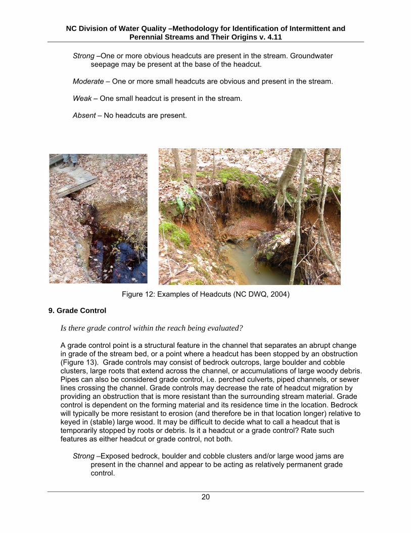
8. Headcuts
Is there a headcut at the upstream end of the reach being evaluated? Are there one or more headcuts within the reach being evaluated?
A headcut is an abrupt vertical drop in the bed of a stream that is an active erosional feature. It often resembles a small intermittent waterfall (or a miniature cliff) and may have a deep pool at the base resulting from scour. Intermittent or perennial streams sometimes begin at a head cut in the piedmont and mountains. Headcuts are transient structures of the stream and often exhibit relatively rapid upstream movement during periods of high flow. Groundwater seepage may also be present from the face or base of a head cut (Figures 11, 12).
Upstream streambed
headwall
Downstream Streambed Seepage from headwall Water table
Wetted streambed
Figure 11: Headcut formation (Modified from Ken Fritz, EPA)
NC Division of Water Quality –Methodology for Identification of Intermittent and Perennial Streams and Their Origins v. 4.11
20
Strong –One or more obvious headcuts are present in the stream. Groundwater seepage may be present at the base of the headcut.
Moderate – One or more small headcuts are obvious and present in the stream. Weak – One small headcut is present in the stream. Absent – No headcuts are present.
Figure 12: Examples of Headcuts (NC DWQ, 2004) 9. Grade Control
Is there grade control within the reach being evaluated?
A grade control point is a structural feature in the channel that separates an abrupt change in grade of the stream bed, or a point where a headcut has been stopped by an obstruction (Figure 13). Grade controls may consist of bedrock outcrops, large boulder and cobble clusters, large roots that extend across the channel, or accumulations of large woody debris. Pipes can also be considered grade control, i.e. perched culverts, piped channels, or sewer lines crossing the channel. Grade controls may decrease the rate of headcut migration by providing an obstruction that is more resistant than the surrounding stream material. Grade control is dependent on the forming material and its residence time in the location. Bedrock will typically be more resistant to erosion (and therefore be in that location longer) relative to keyed in (stable) large wood. It may be difficult to decide what to call a headcut that is temporarily stopped by roots or debris. Is it a headcut or a grade control? Rate such features as either headcut or grade control, not both.
Strong –Exposed bedrock, boulder and cobble clusters and/or large wood jams are present in the channel and appear to be acting as relatively permanent grade control.

NC Division of Water Quality –Methodology for Identification of Intermittent and Perennial Streams and Their Origins v. 4.11
21
Moderate –Some exposed bedrock, boulder and cobble clusters, and/or large wood and roots are present in the channel and appear to be acting as grade control, but only with moderate longevity.
Weak – No bedrock, few to no boulder clusters, and/or few to no roots or wood are
present but some may be acting as short-term grade control. Absent – No grade control structures are in the stream.
Figure 13: Example of grade control in Umstead State Park, Wake County NC (Susan Howard 2007).
10. Natural Valley
Is there a well-developed valley at the location of the reach being evaluated? A valley is an extended depression in the Earth's surface that is usually bounded by uplands, hills or mountains and is commonly occupied by a river or stream. Valley formation results from erosion or gradual wearing down of the land by wind and water. In river valleys for example, the river acts as an erosional agent by grinding down the rock or soil and creating a valley. Valley shapes vary but are typically steep-sided canyons or broad plains and their form is dependent on the erosional agent, the slope of the land, local and regional rock or soil material and time (Briney 2009). In North Carolina, current valley formation and maintenance results from water erosion. The frequency and magnitude of water flowing over the land surface over time, in conjunction with the erodibility of underlying rock and soil material, determine the degree of valley formation. This indicator addresses the degree of valley development due to water as an erosional agent. In the continuum of a single valley, the degree of development of that valley usually increases in the downstream direction. Variation in the signature of a well-developed valley occurs across geologic provinces. When looking at the local topography in the field, does the land slope towards the channel thereby indicating a “draw” or valley? In other words, does the land have slopes that seem to drain to or indicate a natural valley?

NC Division of Water Quality –Methodology for Identification of Intermittent and Perennial Streams and Their Origins v. 4.11
22
Strong – Well defined valley indicated by all surrounding land sloping downward to the
valley bottom or stream. Moderate – Defined valley indicated by most of the surrounding land sloping downward
to the valley bottom or stream. Weak –Subtle valley indicated by some of the surrounding land sloping downward to the
valley bottom or stream. Absent – No indication of surrounding land sloping to the valley bottom or stream.
Channel located on side slope indicative of an artificial channel or stream relocation.
11. Second (or Greater) Order Channel
Is the channel reach being evaluated second order or greater, considering all intermittent and perennial channels that discharge to it?
The higher the channel order, the more likely a stream is to be perennial. Determine the order of the reach being evaluated in accordance with the Strahler Stream Order method (Strahler 1952), considering all intermittent and perennial stream segments that discharge to the evaluation reach. Due to inaccurate depiction of headwaters streams on maps, ground reconnaissance of the stream upstream of the reach being evaluated is preferred, when feasible. Use evidence of intermittent or perennial stream segments upstream of the evaluation reach on a USGS 1:24,000 topographic map or NRCS county soil survey map (printed version) when ground reconnaissance is not feasible. It is often difficult to evaluate stream order on channels that have been altered by upstream development. This indicator should be based on the natural condition of the stream network, when possible. Review of historic data such as a topographic or soils map that predates the development may be helpful. If such information is not available, then base the stream order determination on the current situation.
YES – The reach being evaluated is second (or greater) order based on intermittent or
perennial stream segments discharging to it. NO – The reach being evaluated is part of a first order stream or stream order cannot be
determined. B. Hydrologic Indicators 12. Presence of Baseflow
Does the presence of flow more than 48 hours after rainfall that produces runoff and evidence of groundwater discharge into the evaluation reach indicate a significant period of baseflow in the stream? Water flowing in the channel more than 48 hours after rainfall that produces runoff is clear evidence of baseflow supplied by groundwater discharge from saturated soils below the water table adjacent to the stream. Even when there is no visible flow above the channel

NC Division of Water Quality –Methodology for Identification of Intermittent and Perennial Streams and Their Origins v. 4.11
23
bottom, there may be slow groundwater discharge into, and downstream flow through, the hyporheic zone (Figure 14). The hyporheic zone is the accumulation of coarse-textured sediments in the bed and sides of the channel that may be up to 2-3 ft deep in small streams. A functioning part of the stream, the hyporheic zone is the site where much of the groundwater discharge to the stream occurs, the source of downstream flow, and the location of biological and chemical processes associated with aquatic functions of the stream.
Figure 14: Illustration of groundwater flow and hyporheic zone (Winter et al.,1998).
The presence of a seasonal high water table or groundwater discharge (e.g., seeps or springs) from the bank above the elevation of the channel bottom indicates a relatively reliable source of baseflow to a stream.
Strong – Water is present and flowing in the thalweg region of the channel throughout the evaluation reach and there is significant baseflow through the riffles or other shallow zones. Evidence of groundwater discharge into the channel or a groundwater table above the thalweg is readily observable throughout the reach.
Moderate – Water is present in the thalweg region of the channel throughout the
evaluation reach and there is a small amount of baseflow through the riffles or other shallow zones. Evidence of groundwater discharge into the channel or a groundwater table slightly above the thalweg is observable in the reach but not abundant throughout the reach.
Weak – Water is standing in pools and the hyporheic zone is saturated, but there is not
visible flow through the riffles or other shallow zones of the thalweg. Evidence of groundwater discharge is present, but requires considerable time to locate. The groundwater table is at or slightly above the level of water in the pools.
Absent – There is little to no visible water in the thalweg region of the channel. There is
no evidence of groundwater discharge into the channel and the groundwater table is at or below the deepest parts of the channel.
13. Iron Oxidizing Bacteria
In slow moving (or stagnant) areas of the stream, are there clumps of “fluffy” rust-red material in the water, on the sides of the bank or in the streambed? Are there red or rust-

NC Division of Water Quality –Methodology for Identification of Intermittent and Perennial Streams and Their Origins v. 4.11
24
colored stains on the soil surface and/or an “oily sheen” or “oily scum” on the water surface? Iron oxidizing bacteria derive energy by converting iron in the ferrous form (Fe2+) to the ferric form (Fe3+), which then combines with oxygen to produce iron oxide, essentially rust. Since the reaction is dependent on oxygen presence it is more likely to be found in areas of the wetted channel where oxygen-poor groundwater is just reaching the surface. Iron oxidizing bacteria can be detected in these areas by looking for the iron oxide waste product, often appearing as a rusty red or orange material in “fluffy” clumps or as a stain within the wetted channel where groundwater enters (Figure 15). Staining can be visible in channels without water present as well. The bacteria can also produce an oily sheen on the water surface that breaks apart when disturbed, though other bacteria can produce a similar sheen. However, a sudden or unusual occurrence may indicate a petroleum product release from an underground fuel storage tank. One way to differentiate iron-oxidizing bacteria from oil releases is to trail a small stick or leaf through the film. If the film breaks up into small islands or clusters, it is most likely bacterial in origin. However, if the film swirls together, it is most likely a petroleum discharge.
Strong – Abundant iron oxidizing bacteria is observed. Moderate – Some iron oxidizing bacteria is observed. Weak – Very little iron oxidizing bacteria is observed. Absent – No iron oxidizing bacteria is observed.
Figure 15: Iron oxidizing bacteria. Figure on right depicts iron bacteria on a twig. 14. Leaf litter
Is leaf litter accumulating in the streambed? Perennial streams with riparian vegetation should continuously transport plant material through the channel. Leaves and lighter debris are typically present throughout the length of non-perennial streams, whereas little to no leaves are present in streams with constant or

NC Division of Water Quality –Methodology for Identification of Intermittent and Perennial Streams and Their Origins v. 4.11
25
near-constant flow. This indicator may be more difficult to discern during autumn, especially between rain events in areas with deciduous riparian vegetation. Accumulations of organic debris, including leaves, on the upstream side of obstructions are another indicator and are not considered to be leaf litter.
Strong – Abundant amount of leaf litter is present throughout the length of the stream. Greater than 80% of the active channel is covered with leaves and the thalweg substrate is not visible.
Moderate – Leaf litter is present throughout most of the stream’s reach with some
accumulation beginning on the upstream side of obstructions and in pools. Between 25% and 80% of the active channel bottom is covered with leaves and portions of the thalweg is visible.
Weak – Leaf litter is present and is mostly accumulated in pools.. Between 5% and 25%
of the streambed is covered with leaves and most of the thalweg is visible. Absent – Leaf litter is not present in the fast moving areas of the reach but there may be
some present in the pools. Less than 5% of the active channel bottom is covered with leaves. The thalweg is swept clear of leaf litter and the substrate is continuously visible throughout the assessment reach.
15. Sediment on Plants or Debris
Is fine sediment deposited on plants or debris in the channel or on the active floodplain, indicative of recent high flows and suspended sediment transport?
The transportation and processing of sediment is a main function of streams. Therefore, evidence of fine sediment on plants or other debris in the stream may be an important indicator of the persistence of flow and the transport of suspended sediment. Note that sediment production and delivery to streams in stable, vegetated watersheds is usually less than in disturbed watersheds. Look for silt and clay accumulation in thin layers on debris or rooted aquatic vegetation, and on plants and debris on the bank and floodplain immediately adjacent to the stream. Note any upstream land-disturbing activities that may contribute greater amounts of sediment to the stream.
Strong – Fine sediment found readily on plants and debris within the stream, on the
streambank, and within the floodplain throughout the length of the stream. Moderate – Fine sediment found on plants or debris within the stream although not
prevalent along the stream. Weak – Fine sediment is isolated in small amounts along the stream. Absent – No sediment is present on plants or debris.
16. Organic Drift Lines
Are there accumulations of organic debris in piles or lines in the channel or on the active floodplain indicative of recent high flows?

NC Division of Water Quality –Methodology for Identification of Intermittent and Perennial Streams and Their Origins v. 4.11
26
Organic drift lines are defined as twigs, sticks, logs, leaves, and any other floating materials piled up on the upstream side of obstructions in the stream, on the streambank, in overhanging branches, and/or in the floodplain that indicate high stream flows. Ephemeral streams usually exhibit fewer or no drift lines within their channels unless downstream of a storm drain or areas with high runoff potential. The magnitude of the accumulation of drift may be influenced by watershed characteristics and sources of debris. For example, streams in watersheds dominated by herbaceous vegetation may not exhibit drift lines.
Strong – Large drift lines are prevalent along the upstream side of obstructions within the channel and the floodplain.
Moderate – Large drift lines are dispersed mostly within the channel. Weak – Small drift lines are present within the channel. Absent – No drift lines are present.
17. Soil-based Evidence of a Seasonal High Water Table
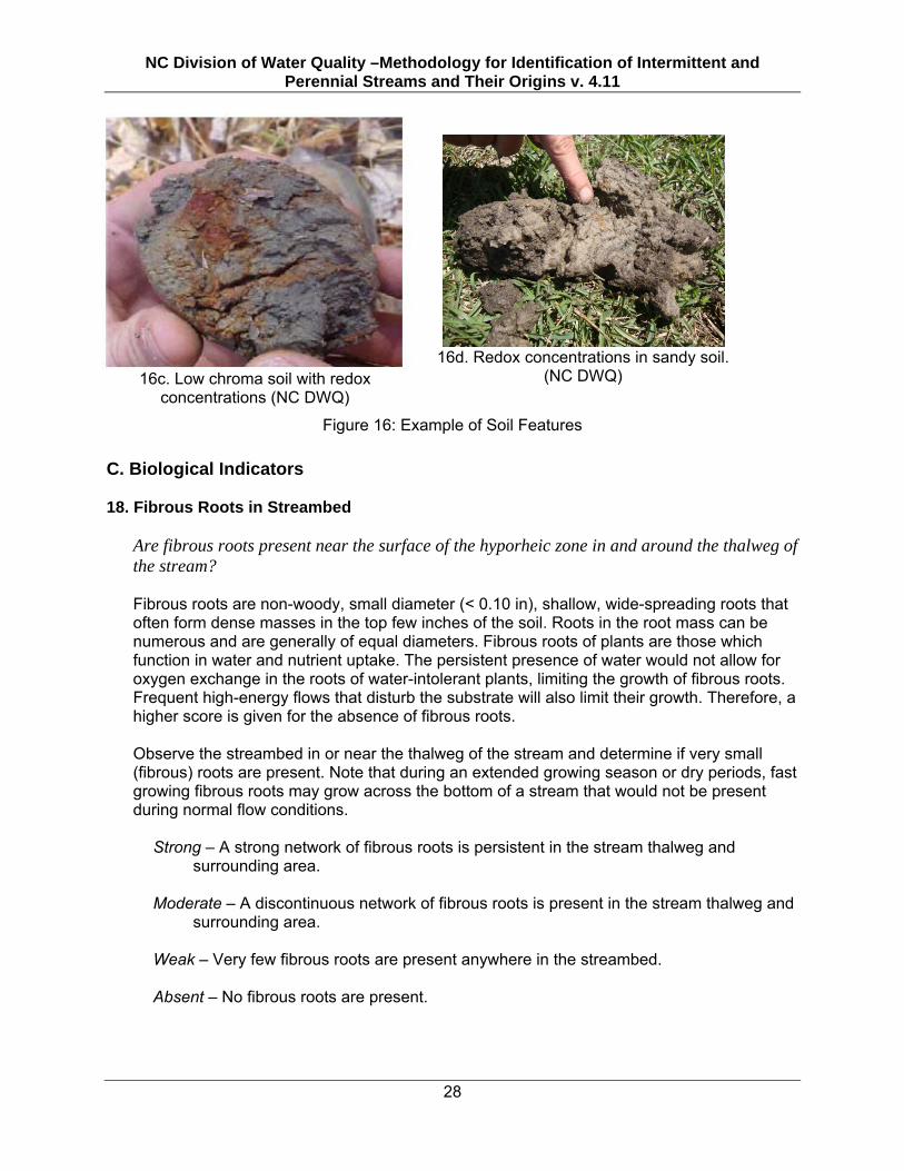
Is there evidence of a seasonal high water table in the soil at the toe of the stream bank, or the base of a head cut above the elevation of the thalweg of the evaluation reach? The presence of a seasonal water table in the soil above the thalweg elevation is evidence of groundwater discharge into the channel that sustains an annual extended period of baseflow. In soils with fluctuating water tables near the surface, the level of the seasonal high water table is routinely estimated from soil color variation in soils with silts and clays that have iron and manganese oxides. When the soil is unsaturated and aerobic, chemically oxidizing conditions in the soil water produce oxidized forms of iron and manganese that are precipitates that coat soil particles and produce brown, yellow, and red colors. When the soil is saturated and anaerobic, chemically reducing conditions in the soil water produce reduced forms of iron and manganese that are colorless ions in solution. Gray or neutral low chroma soil colors result because the colors of the soil particles are visible. In sandy soils with very low clay content, long periods of saturation result in accumulation of organic matter that coats the sand grains and produces dark low chroma colors. In soils with frequent, long periods of saturation the oxidation/reduction reactions of iron and manganese produce color variations called redoximorphic features (formerly called mottles). The degree of development of redoximorphic features is indicative of the frequency and duration of periods of soil saturation. Weakly developed redoximorphic features in the soil at the toe of the bank above the channel bed are common in intermittent streams and indicate the level of the seasonal high water table. Strongly developed redoximorphic features are common in the soils at the toe of banks and in the streambed sediments of perennial streams. Ephemeral streams have oxidized soils in the bed and bank. Types of redoximorphic features are: (1) depleted matrix – matrix color has chroma ≤ 2; (2) depletions – zones of low chroma (≤ 2) within a matrix of higher chroma; (3) concentrations - soft masses or pore linings; zones of accumulation of oxidized iron and manganese, bright yellow, orange, or red colors (Figure 16).

NC Division of Water Quality –Methodology for Identification of Intermittent and Perennial Streams and Their Origins v. 4.11
27
Soil colors are identified with Munsell soil color charts. The matrix color of a soil ped is the color of more than 50% of the face of a broken ped. Use a soil auger to obtain at least three 6-8 inch cores in the toe of the bank above the thalweg elevation in a riffle or shallow zone of the channel. Look for redoximorphic features below by breaking open chunks of soil (peds). Note that non-soil such as relatively young alluvial accumulations of coarse sand, gravel, and cobble in the stream bank or hyporheic zone will not have redoximorphic features or other hydric soil indicators. YES – In the soil of the stream bank or base of a headcut within at least six inches above the average elevation of riffles or other shallow zones in the thalweg is found a soil layer at least two inches thick that has at least one indicator of a seasonal high water table. NO – In the soil of the stream bank or base of a headcut within at least six inches above the average elevation of riffles or other shallow zones in the thalweg is found no indicator a seasonal high water table. Common indicators of a seasonal high water table include but are not limited to: • More than 60% of the ped face is gleyed, i.e. color is on a gley page of the Munsell
• More than 60% of the ped face is chroma ≤ 2 with or without concentrations
• In streams with floodplains, more than 60% of the ped face is chroma ≤ 4 with 10% or more redox concentrations
• More than 60% of the ped face is chroma ≤ 2 with 10% or more of redox depletions
• In a sandy soil, more than 70% of the sand grains are coated with organic matter
• In a sandy soil, there is streaking or splotches of organic matter
• The soil has mucky mineral texture
16a. Upland Soil (chroma >3) (NC DWQ) 16b. Hydric soil depicting gleying (chroma<2) (NC DWQ)
NC Division of Water Quality –Methodology for Identification of Intermittent and Perennial Streams and Their Origins v. 4.11
28
16c. Low chroma soil with redox concentrations (NC DWQ)
16d. Redox concentrations in sandy soil.
(NC DWQ)
Figure 16: Example of Soil Features C. Biological Indicators 18. Fibrous Roots in Streambed
Are fibrous roots present near the surface of the hyporheic zone in and around the thalweg of the stream?
Fibrous roots are non-woody, small diameter (< 0.10 in), shallow, wide-spreading roots that often form dense masses in the top few inches of the soil. Roots in the root mass can be numerous and are generally of equal diameters. Fibrous roots of plants are those which function in water and nutrient uptake. The persistent presence of water would not allow for oxygen exchange in the roots of water-intolerant plants, limiting the growth of fibrous roots. Frequent high-energy flows that disturb the substrate will also limit their growth. Therefore, a higher score is given for the absence of fibrous roots. Observe the streambed in or near the thalweg of the stream and determine if very small (fibrous) roots are present. Note that during an extended growing season or dry periods, fast growing fibrous roots may grow across the bottom of a stream that would not be present during normal flow conditions.
Strong – A strong network of fibrous roots is persistent in the stream thalweg and surrounding area.
Moderate – A discontinuous network of fibrous roots is present in the stream thalweg and
surrounding area. Weak – Very few fibrous roots are present anywhere in the streambed. Absent – No fibrous roots are present.
NC Division of Water Quality –Methodology for Identification of Intermittent and Perennial Streams and Their Origins v. 4.11
29
19. Rooted Upland Plants in Streambed
Are rooted upland plants growing in or near the thalweg area of the stream?
This attribute relates flow to the absence of rooted plants, since flow will often act as a deterrent to plant establishment by removing seeds or preventing aeration to roots. A higher score is given for the absence of rooted plants. Focus should be on the presence of upland (i.e. FAC or drier as listed in the National List of Vascular Plant Species that Occur in Wetlands: 1996 National Summary (U.S. FWS, 1997) plants in or near the thalweg of the stream. Plants growing on any part of the bank of the stream should not be considered. Note, however, there will be exceptions to this attribute. For example, rooted plants can be found in shaded perennial streams with moderate flow but in most cases these plants will be water tolerant (FACW or wetter), in which case they should be considered under indicator 26, Wetland Plants in Streambed. Cases where rooted upland plants are present in the streambed may indicate ephemeral or intermittent flow.
Strong –Rooted plants are observed and cover over 75% of the streambed. Moderate – Rooted plants are observed and cover approximately 20-75% of the
streambed. Weak – Rooted plants are observed and cover less that 20% of the streambed and most
are in the thalweg. Absent – No rooted plants are observed.
20. Benthic Macroinvertebrates
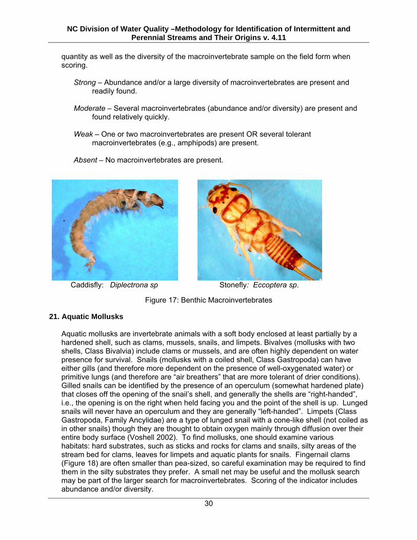
“Benthic macroinvertebrates” is a broad term applied to many different types of invertebrates that live on or within the stream substrate. In a broad sense, this term can be applied to a wide range of animals that live in this zone. Crayfish and mollusks are assessed separately in this method, so this indicator is meant to assess primarily aquatic insects (i.e., mayflies, stoneflies, caddisflies, hellgrammites, midges), amphipods, isopods, and annelids (worms and leeches). The larval stages of many aquatic insects (Figure 17) are well-established indicators of flow duration since a continuous aquatic habitat is required for these species to mature. Though insects are defined in part by having three pairs of legs, this characteristic can be difficult to see or non-existent in some larvae. There is great variability in appearance, from legless, soft, “wormlike” or “maggotlike” forms (e.g., true flies [Order Diptera]); grub-like forms with variably hardened body sections and obvious legs (e.g., caddisflies [Order Trichoptera] and some beetle larvae [Order Coleoptera]); to more complex and distinctive body forms (e.g., mayflies [Order Ephemeroptera], stoneflies [Order Plecoptera], hellgrammites [Order Megaloptera], and dragonflies and damselflies [Order Odonata]). In general, caddisflies, mayflies, stoneflies, and damselflies are very good indicators of at least intermittent (and in many cases, perennial) flow. These are discussed more fully in Section 3 – Guidance for the Determination of Perennial Streams. Examine rocks and sticks in the stream and use a small net to sample a variety of habitats including riffles, pools, roots, undercut banks, leaf packs and the substrate. Note both the
NC Division of Water Quality –Methodology for Identification of Intermittent and Perennial Streams and Their Origins v. 4.11
30
quantity as well as the diversity of the macroinvertebrate sample on the field form when scoring.
Strong – Abundance and/or a large diversity of macroinvertebrates are present and readily found.
Moderate – Several macroinvertebrates (abundance and/or diversity) are present and
found relatively quickly. Weak – One or two macroinvertebrates are present OR several tolerant
macroinvertebrates (e.g., amphipods) are present. Absent – No macroinvertebrates are present.
Caddisfly: Diplectrona sp
Stonefly: Eccoptera sp.
Figure 17: Benthic Macroinvertebrates 21. Aquatic Mollusks
Aquatic mollusks are invertebrate animals with a soft body enclosed at least partially by a hardened shell, such as clams, mussels, snails, and limpets. Bivalves (mollusks with two shells, Class Bivalvia) include clams or mussels, and are often highly dependent on water presence for survival. Snails (mollusks with a coiled shell, Class Gastropoda) can have either gills (and therefore more dependent on the presence of well-oxygenated water) or primitive lungs (and therefore are “air breathers” that are more tolerant of drier conditions). Gilled snails can be identified by the presence of an operculum (somewhat hardened plate) that closes off the opening of the snail’s shell, and generally the shells are “right-handed”, i.e., the opening is on the right when held facing you and the point of the shell is up. Lunged snails will never have an operculum and they are generally “left-handed”. Limpets (Class Gastropoda, Family Ancylidae) are a type of lunged snail with a cone-like shell (not coiled as in other snails) though they are thought to obtain oxygen mainly through diffusion over their entire body surface (Voshell 2002). To find mollusks, one should examine various habitats: hard substrates, such as sticks and rocks for clams and snails, silty areas of the stream bed for clams, leaves for limpets and aquatic plants for snails. Fingernail clams (Figure 18) are often smaller than pea-sized, so careful examination may be required to find them in the silty substrates they prefer. A small net may be useful and the mollusk search may be part of the larger search for macroinvertebrates. Scoring of the indicator includes abundance and/or diversity.

NC Division of Water Quality –Methodology for Identification of Intermittent and Perennial Streams and Their Origins v. 4.11
31
Strong – Abundance and/or a large diversity of mollusks are present and readily found. Moderate – Several mollusks are present and found relatively quickly. Weak – One or two mollusks are present. Absent – No mollusks are present.
Figure 18: Fingernail claims (NC DWQ 1998) 22. Fish
Fluctuating water levels of intermittent streams provide unstable and stressful habitat conditions for fish communities. When looking for fish, all available habitats should be observed, including pools, riffles, root clumps, and other obstructions. In small streams, the majority of species usually inhabit pools and runs. Fish should be easily observed within a minute or two. Fish will seek cover once alerted to your presence, so be sure to look for them slightly ahead of where you are walking along the stream. Check several areas along the stream sampling reach, especially underneath undercut banks. In most cases, fish are indicators of perennial streams, since fish will rarely inhabit an intermittent stream. Gambusia (mosquitofish) should not be considered as a perennial indicator due to their extremely short life cycle and tolerance for stressful conditions, such as low oxygen levels, but may be considered as present for this indicator.
Strong – Many fish (>3) are readily observed. Moderate – Several fish (2-3) are observed. Weak – One fish is observed. Absent – No fish are observed.
23. Crayfish
Most species of crayfish are associated with aquatic or wet environments such as streams and wetlands. A small net can be used to examine small pools, under rocks, under logs,

NC Division of Water Quality –Methodology for Identification of Intermittent and Perennial Streams and Their Origins v. 4.11
32
sticks or within leaf packs in the stream for crayfish. Crayfish associated with small holes or “chimneys” in the muddy streambank or floodplain may be indicators of wet soils (wetlands) rather than streams. The presence of chimneys should not be considered for this metric.
Strong – Several (3 +) or very large crayfish are present and were found quickly. Moderate – A few (1-2) crayfish are present. Weak – One crayfish is present. Absent – No crayfish are present.
24. Amphibians
Amphibians such as salamanders, frogs, and toads require water, or at least moist conditions, for egg laying and larval development. Many salamander species’ immature, gilled larvae require aquatic environments until they transform to adults. All frogs and toads lay their eggs in fresh water and tadpoles (the larval form of toads and frogs) require water for development. Older (>1 year old) salamander larvae can be a very good indicator of relatively permanent waters. Abundance of one species (Southern Two-Lined Salamanders, Eurycea cirrigera) has been found to be positively correlated with watershed area in headwater streams, and the presence of >1 year-old larvae was found to be an indicator of perennial water (Johnson et al. 2009). This same study did not find any larval salamanders in any ephemeral streams, suggesting that their presence, regardless of age, suggests at least intermittent flow. The tadpoles of many species of frogs and toads require 2-3 months before final metamorphosis to adult occurs. However, the very large tadpoles of the American Bullfrog (Rana catesbeiana), River Frog (Rana heckscheri), and Carpenter Frog (Rana virgatipes) require a year or more before metamorphosis to adults. When large specimens of these species are found, it is a strong indicator of the presence of water over several seasons. Seasonality may have to be considered when assessing this indicator. Many species of salamanders in the piedmont and coastal plain areas of NC have a relatively short larval stage and develop from egg to adult over a single fall-to-spring period, so their presence may not be as strong of an indicator of perennial flow during this time of the year in this area of the state unless species can be definitively identified. In the mountain ecoregion of NC, salamander diversity is much higher with more varied life histories, including many more species with longer larval stages, so this rule of thumb may not apply in these areas of the state. Many tadpoles develop from egg to adult over the summer, suggesting that their presence during this time of year is a strong indicator of perennial flow, as this is usually the driest portion of the year. Salamanders (Figure 19) and tadpoles can be found under rocks, on stream banks and on the bottom of the stream. They may also appear in the benthic sample. Frogs and tadpoles typically inhabit the shallow, slower moving waters of the pools and near the sides of the bank. Amphibian eggs, also included as an indicator, can be located on the bottom of rocks and in or on other submerged debris. They are usually observed in gelatinous clumps or strings of eggs.

NC Division of Water Quality –Methodology for Identification of Intermittent and Perennial Streams and Their Origins v. 4.11
33
Figure 19: Salamander
Strong – Abundance and/or a large diversity of amphibians are present and readily
found. Moderate – A few (2-3) amphibians are present and found relatively quickly. Weak – One amphibian is present. Absent – No amphibians are present.
25. Algae
Benthic algae are photosynthetic organisms that live on substrates in the stream, such as on rocks, sticks, leaves, or plants. These algae can take the form of long, hair-like filaments, a crust-like coating, or as an invisible (but palpable) slimy biofilm growing on appropriate substrates. The most commonly seen in streams include blue-green algae (actually more accurately classified in the bacterial phylum Cyanobacteria), green algae (algal division Chlorophyta), and diatoms (algal division Bacillariophyta) (Stevenson, 1996). Benthic algal abundance is strongly influenced by the amount of sunlight reaching the stream, relative rate of stream discharge, availability of appropriate substrates, and level of nutrient enrichment. Look for green or blue-green filaments or mats, or golden brown "crusts" on appropriate substrates within the wetted channel. Also feel submerged rocks, plants, leaves, sticks, or other available substrates; a "slimy" coating can indicate a biofilm consisting of a mix of diatoms, other algae, bacteria, and fungus that is collectively referred to as periphyton, and should also be considered when rating this indicator.
Strong – Abundant algae is observed throughout the reach. Moderate – Some algae is observed in a few locations in the reach. Weak – Very little algae is observed through the reach. Absent – No algae is observed through the reach.

NC Division of Water Quality –Methodology for Identification of Intermittent and Perennial Streams and Their Origins v. 4.11
34
20a. Filamentous algae, Source:
www.duluthstreams.org
20b. Filamentous algae Source:
www.aquafiber.com
Figure 20: Algae 26. Wetland Plants in Streambed (FACW and wetter)
The U.S. Army Corp of Engineers wetland delineation procedure utilizes a plant species classification system upon which soil moisture regimes can be inferred. This same system can be used to infer the duration of soil saturation in streams. Small, low gradient, low velocity intermittent and perennial streams with adequate sunlight will often have OBL (obligate wetland) and FACW (facultative wetland) plants, aquatic bryophytes such as Fontanalis, or submerged aquatic vegetation growing in the stream bed. All wetland designations are defined by National List of Vascular Plant Species that Occur in Wetlands: 1996 National Summary (U.S. FWS 1997).
OBL: Obligate Wetland, occurs almost always (estimated probability 99%) under natural conditions in wetlands.
FACW: Facultative Wetland, usually occurs in wetlands (estimated probability 67%-99%), but occasionally found in non-wetlands.
FAC: Facultative, Equally likely to occur in wetlands or non-wetlands (estimated probability 34%-
66%). FACU: Facultative Upland, Usually occurs in non-wetlands (estimated probability 67%-99%), but
occasionally found on wetlands (estimated probability 1%-33%). UPL: Obligate Upland, Occurs in wetlands in another region, but occurs almost always (estimated
probability 99%) under natural conditions in non-wetlands in the regions specified. If a species does not occur in wetlands in any region, it is not on the National List.

NC Division of Water Quality –Methodology for Identification of Intermittent and Perennial Streams and Their Origins v. 4.11
35
SECTION 3 – Guidance for the Determination of Perennial Streams Background
The NC DWQ utilizes a numerical cutoff of 19 points with this evaluation form as an appropriate value to classify a stream as at least “intermittent”. As part of an investigation for the City of Greensboro, personnel with Law Engineering and Environmental Services (now MacTec Environmental Services), with the support of NC DWQ personnel, used a modification of the NC DWQ stream classification method and recommended a numerical cutoff for a perennial stream origin in the piedmont of 30 points (Lawson, et al. 2002). Recent and on-going Investigations NC DWQ biologists have been looking for the presence of long-lived aquatic species as reliable determinants for perennial channels. These investigations suggest that the presence of a select group of benthic macroinvertebrates that require water for their entire life cycles (aquatic taxa) is a reliable method to determine the origins of perennial channels. A proposed list of these organisms is included with this policy revision (Tables 2 and 3). The NC DWQ is currently completing an investigation of the ecological functions of intermittent streams. Results from this federally funded investigation also have corroborated the technique of using a suite of aquatic insect taxa to determine perennial stream origins. Additionally, research related to headwater stream mapping is defining physical and hydrologic characteristics of intermittent and perennial origins. NC DWQ Policy for the Definition of Perennial Stream Origins A perennial stream is defined as a well-defined channel that contains water year round during a year of normal rainfall1 with the aquatic bed located below the water table for most of the year (15A NCAC 2B.). This definition also notes that perennial streams exhibit the typical biological, hydrologic, and physical characteristics commonly associated with the continuous conveyance of water.
A stream is perennial when any of the following criteria are met:
1. Biological indicators such as fish (except Gambusia), crayfish (in channel), amphibians (larval salamanders and large, multi-year tadpoles), or clams are present. If only crayfish or fingernail clams are present, a numerical value of at least 18 on the geomorphology section of the most current version of the NC DWQ stream classification form is required.
OR
2. A numerical value of at least 30 points is determined from the most recent version of the NC DWQ stream identification form2.
OR
1 Normal Rainfall is defined as the 30 year average, provided by NOAA National Climatic Data Center, computed at the end of each
decade. These data are available as annual and monthly means. 2 Use of this form requires Division-based (NC DWQ) or approved training (or appropriate certification in accordance with GS 143-
214.25)

NC Division of Water Quality –Methodology for Identification of Intermittent and Perennial Streams and Their Origins v. 4.11
36
3. More than one benthic macroinvertebrate that requires water for their entire life cycles
are present as later instar larvae3. A list of the benthic organisms commonly collected by NC DWQ biologists during perennial stream determinations are shown in Tables 2 and 3.
NC DWQ staff suggest that a stream be examined using these three criteria in the sequence above – namely, a field examination should first look for criterion 1 and then criterion 2. If the channel does not meet either of these two criteria and the field biologist believes the channel to be perennial, then the third criterion should be utilized, however identification by a well-trained aquatic entomologist is required for the proper use of this criterion. In most instances, the use of either of the first two criteria should be sufficient to make a stream determination.
Table 2: Ephemeroptera, Plecoptera and Trichoptera (EPT) perennial stream indicators
Order: Ephemeroptera (Mayflies)
Plecoptera (Stoneflies)
Trichoptera (Caddisflies)
Family: Baetidae Peltoperlidae Hydropsychidae Caenidae Perlidae Lepidostomatidae Ephemerellidae Perlodidae Limnephilidae Ephemeridae Molannidae Heptageniidae Odontoceridae Leptophlebiidae Philopotamidae Siphlonuridae Polycentropidae Psychomyiidae Rhyacophilidae
Table 3: Additional indicators of perennial streams
Megaloptera Odonata Diptera Coleoptera Mollusca
Family: Corydalidae Aeshnidae Ptychopteridae Elmidae Unionidae Sialidae Calopterygidae Psephenidae Ancylidae Cordulegastridae Planorbidae Gomphidae Pleuroceridae Libellulidae Family & Genus: Tipulidae
Tipula sp. Dryopidae Helichus (adult)
3 Recognition and/or identification of these organisms will require Division-based (NC DWQ) or approved training.
NC Division of Water Quality –Methodology for Identification of Intermittent and Perennial Streams and Their Origins v. 4.11
37
Special Provision for Coastal Plain Perennial Streams
Reduced topography, which causes fewer channel-forming features, can make the geomorphology section of the stream form problematic in the Middle Atlantic Coastal Plain and Southeastern Plains ecoregions (Griffith et. al. 2002) – approximately east of I-95. In this area, biology should take precedence over geomorphology for determining a stream. Therefore the criteria should be utilized in the following sequence: 1, 3, and then 2.
History of the Guidance for the Determination of the Origin of Perennial Streams Version 1.0 – Developed in 1997/1998. Fish, salamanders, turtles, crayfish and multiyear (large)
tadpoles were used as indicators. Version 2.1 – Added stoneflies, mayflies and caddisflies
Version 2.2 – Added section about the coastal plain
Version 2.3 – Added taxa lists (Tables 5 and 6)
Version 2.4 – Effective February 28, 2005. Added tables of macroinvertebrate taxa found in perennial streams. Issued for public comment October 13, 2004.
References
Allen, J.R.L., 1970, Physical processes of sedimentation: Earth Science Series No. 1, Elsevier,
New York, 248 p. Beaudry, L.J., J. McConnachie, P.G. Beaudry and R.G. Pike. 2006. Accessed July 2010.
Appendix 1: Glossary of Hydrologic and Geomorphic Terms Draft January 2006. http://www.forrex.org/program/water/PDFs/Compendium/Compendium_Appendix01.pdf
Bogan, A.E. 2002. Workbook and key to the freshwater bivalves of North Carolina. North
Carolina Freshwater Mussel Conservation Partnership. Raleigh, NC. 101 pp, 10 color plates. Accessed July 2010. http://naturalsciences.org/files/documents/research-collections/BivalveWorkbook.pdf
Briney, Amanda 2009. http://geography.about.com/od/physicalgeography/a/valleyformation.htm Church, M. 1992. Channel Morphology and Typology. In The Rivers Handbook: Hydrological
and Ecological Principles. Callow, C., and G. Petts (eds.). Oxford: Basil Blackwell, p. 126-143.
Federal Interagency Stream Restoration Working Group (FISRWG). 1998. Stream Corridor
Restoration: Principles, Processes, and Practices. Federal Interagency Stream Restoration Working Group (FISRWG). GPO Item No. 0120-A; SupDocs No. A 57.6/2:EN 3/PT.653.
Fletcher, Peter C. and Peter L. M. Veneman. Soil Morphology As An Indicator Of Seasonal High
Water Tables. Accessed June 2009. http://nesoil.com/properties/eshwt.htm. Fritz, Ken 2007. Personal Communication. US EPA Office of Research and Development.

NC Division of Water Quality –Methodology for Identification of Intermittent and Perennial Streams and Their Origins v. 4.11
38
Gordon, N. D., T. A. McMahon, B. L. Finlayson, C. J. Gippel, and R. J. Nathan. 2004. Stream Hydrology: An Introduction for Ecologists. John Wiley and Sons, 429 pages.
Griffith, G. E., J. M. Omernik, J. A. Comstock, M. P. Schafale, W. H. McNab, D. R. Lenat, T. M.
MacPherson, J. B. Glover, and V. B. Shelburne. 2002. Ecoregions of North and South Carolina (color poster with map, descriptive text, summary tables and photographs): Reston, Virginia, U.S. Geological Survey (map scale 1:1,500,000).
Jackson, Julia A., James P. Mehl, and Klaus K. E. Neuendorf. 2005. Glossary of Geology.
American Geological Institute. Contributor Klaus K. E. Neuendorf. Edition: 5, illustrated, Springer Science & Business, 779 pages.
Johnson, Brent R., K.M. Fritz, K.A. Blocksam, D.M. Walters. 2009. Larval salamanders and
channel geomorphology are indicators of hydrologic permanence in forested headwater streams. Ecological Indicators. 9 (2009) 150-159.
Lawson, J., R. Darling, D. Penrose, and J.D. Gregory. 2002. Stream Identification and Mapping
for Water-Supply Watershed Protection. In Proceedings, Watershed 2002, February 23-27, 2002, Fort Lauderdale, FL.
Leopold, Luna B. 1994. A View of the River. Harvard University Press, Cambridge, Mass.
London, England. Leopold, L. B. and M. G. Wolman. 1957. River Channel Patterns: Braided, Meandering and
Straight: USGS Prof. Paper 282-B, U.S. Geological Survey, Washington, DC. Maidment, David R. Ed. 1993. Handbook of Hydrology. McGraw-Hill, New York. Mertes, L. 1994. Rates of Floodplain Sedimentation on the Central Amazon River. Geology
22:171-74. Middelkoop, H. and N. E. Asselman. 1998. Spatial Variability of Floodplain Sedimentation at the
Event Scale in the Rhine-Meuse Delta, The Netherlands. Earth Surface Processes and Landforms. 23: 561-73.
Munsell Color, 2000. Munsell Soil Color Chart: Baltimore, Md., 22 p. Mueller, Jerry E. 1968. An Introduction to the Hydraulic and Topographic Sinuosity Indexes.
Annals of the Association of American Geographers, Vol. 58, No.2, pp 371-385. NC Wildlife Resources Commission. North Carolina Crayfishes.
http://www.ncwildlife.org/Wildlife_Species_Con/nccrayfishes/index.html. Accessed February 26, 2010.
NC Wildlife Resources Commission. North Carolina Freshwater Mussels.
http://www.ncwildlife.org/Wildlife_Species_Con/WSC_FWMussels_EndFish_Mussels.htm. Accessed February 26, 2010.
Ohio Stream Management Guide: Guide No. 3, Natural Stream Processes.
http://www.dnr.state.oh.us/water/pubs/fs_st/stfs03/tabid/4159/Default.aspx. Accessed July 9, 2010.

NC Division of Water Quality –Methodology for Identification of Intermittent and Perennial Streams and Their Origins v. 4.11
39
Pima, Arizona State Government. Glossary. http://www.pima.gov/cmo/sdcp/kids/gloss.html.
Accessed July 9, 2010. Poff N. L, and J. V. Ward 1989. Implications of Streamflow Variability and Predictability for Lotic
Community Structure: a Regional Analysis of Streamflow Patterns. Canadian Journal of Fisheries and Aquatic Sciences 46:1805–1818.
Richter B. D., J. V. Baumgartner, J. Powell and D. P. Braun. 1996. A Method for Assessing
Hydrologic Alteration Within Ecosystems. Conservation Biology 10: 1163–1174. Ritter, Dale F., R. Craig Kochel, and Jerry R. Miller. 2002. Fluvial Landforms. In Process
Geomorphology. McGraw Hill, New York. Ritter, Michael E. The Physical Environment: an Introduction to Physical Geography.
August 2008. http://www.uwsp.edu/geo/faculty/ritter/geog101/textbook/title_page.html. Accessed July 9, 2010.
Russell, Periann 2008a. Addendum Correction to Mapping Headwater Streams: Intermittent and
Perennial Headwater Stream Model Development and Spatial Application. Final Report for Federal Highway Administration Contract Feasibility Study WBS: 36486.4.2. March, 2008.
Russell, Periann 2008b. Mapping Headwater Streams: Intermittent and Perennial Headwater
Stream Model Development and Spatial Application. Final Report for Federal Highway Administration Contract Feasibility Study WBS: 36486.4.2. January 28, 2008.
Schumm, S and H. Kahn. 1972. Experimental Study of Channel Patterns. Bulletin of the
Geological Society of America (83) pp. 1755-1770. Soil Survey Staff. 1951. Soil Survey Manual. Soil Conservation Service. U.S. Department. of
Agriculture Handbook No. 18. U.S. Government Printing Office, Washington, DC. Soil Survey Division Staff. 1993. Soil Survey Manual. Soil Conservation Service. U.S.
Department of Agriculture Handbook No. 18. U.S. Government Printing Office, Washington, DC.
Stall, John B and Yu-Si Fok 1968. Hydraulic geometry of Illinois streams. Illinois University
Water Resources Center, report no 15, July 1968. 47 p. Stevenson, R. Jan, Max L. Bothwell, and Rex L. Lowe (editors). 1996. Algal Ecology:
Freshwater Benthic Ecosystems. Academic Press. San Diego, CA. Strahler, A. N. 1952. Hypsometric (area altitude) Analysis of Erosional Topology. Geological
Society of America Bulletin, 63, 1117 - 1142. The Stream Study, University of Virginia Department of Environmental Sciences, Charlottesville,
VA. http://people.virginia.edu/~sos-iwla/Stream-Study/StreamStudyHomePage/StreamStudy.HTML Accessed February 26, 2010.
NC Division of Water Quality –Methodology for Identification of Intermittent and Perennial Streams and Their Origins v. 4.11
40
Thompson, Fred G. 1984. Freshwater Snails of Florida: A Manual for Identification. University of Florida Press. Gainseville, FL. 94 pages. Accessed July 9, 2010. http://www.flmnh.ufl.edu/natsci/malacology/fl-snail/snails1.htm
U.S. Army Corps of Engineers. 2005.. Stream Attribute Assessment Methodology
(SAAM)(Piedmont Physiographic Region), Instruction Manual. Norfolk District. http://www.nao.usace.army.mil/Executive/Executive%20Offices/Regulatory%20Office/SAAM_2005/SAAM_IM.pdf Accessed August 2008.
U.S. Army Corps of Engineers. 2007. Reissuance of Nationwide Permits, Definitions. Federal
Register, Vol. 72, No. 47, Monday, March 12, 2007. http://usace.army.mil/CECW/Pages/nw_permits.aspx, Accessed 1-29-2010.
U.S. Department of Agriculture, Natural Resources Conservation Service, 2010. Field Indicators
of Hydric Soils in the United States: A Guide for Identifying and Delineating Hydric Soils, Version 7.0. L.M. Vasilas, G.W. Hurt, and C.V. Noble (eds.). USDA, NRCS, in cooperation with the National Technical Committee for Hydric Soils. http://soils.usda.gov/use/hydric/. Accessed July 9, 2010.
U.S. Fish and Wildlife Service, 1997. National List of Vascular Plant Species that Occur in
Wetlands: 1996 National Summary. http://library.fws.gov/Pubs9/wetlands_plantlist96.pdf. Introduction can be found at: http://www.usace.army.mil/CECW/Documents/cecwo/reg/plants/l96_intro.pdf. Accessed July 9, 2010.
United States Geological Survey. Undated. Tadpoles of the United States and Canada: A
Tutorial and Key. Accessed February 2010. http://www.pwrc.usgs.gov/tadpole/ Voshell, J. Reese. 2002. A Guide To Common Freshwater Invertebrates. McDonald and
Woodward Publishing Company. Blacksburg, VA. 442 pages. Walker, K. F., F. Sheldon, and J. T. Puckridge. 1995. A Perspective on Dryland River
Ecosystems. Regulated Rivers: Research & Management 11: 85–104. Wilson, William E. and John E Moore. 2003. Glossary of Hydrology, American Geological
Institute. Springer, 2003. 248 pages. Winter, T.C., J.W. Harvey, O.L. Franke, and W.M. Alley 1998. Ground Water and Surface Water
A Single Resource. U.S. Geological Survey Circular 1139. Denver, Co. 1998.

NC Division of Water Quality –Methodology for Identification of Intermittent and Perennial Streams and Their Origins v. 4.11
41
NC DWQ Stream Identification Form Version 4.11 Date: Project/Site: Latitude:
Evaluator: County: Longitude:
Total Points: Stream is at least intermittent if ≥ 19 or perennial if ≥ 30*
Stream Determination (circle one) Ephemeral Intermittent Perennial
Other e.g. Quad Name:
A. Geomorphology (Subtotal =_________) Absent Weak Moderate Strong 1a. Continuity of channel bed and bank 0 1 2 3 2. Sinuosity of channel along thalweg 0 1 2 3 3. In-channel structure: ex. riffle-pool, step-pool, ripple-pool sequence 0 1 2 3
4. Particle size of stream substrate 0 1 2 3 5. Active/relict floodplain 0 1 2 3 6. Depositional bars or benches 0 1 2 3 7. Recent alluvial deposits 0 1 2 3 8. Headcuts 0 1 2 3 9. Grade control 0 0.5 1 1.5 10. Natural valley 0 0.5 1 1.5 11. Second or greater order channel No = 0 Yes = 3 a artificial ditches are not rated; see discussions in manual B. Hydrology (Subtotal = _________)
12. Presence of Baseflow 0 1 2 3 13. Iron oxidizing bacteria 0 1 2 3 14. Leaf litter 1.5 1 0.5 0 15. Sediment on plants or debris 0 0.5 1 1.5 16. Organic debris lines or piles 0 0.5 1 1.5 17. Soil-based evidence of high water table? No = 0 Yes = 3 C. Biology (Subtotal = _________) 18. Fibrous roots in streambed 3 2 1 0 19. Rooted upland plants in streambed 3 2 1 0 20. Macrobenthos (note diversity and abundance) 0 1 2 3 21. Aquatic Mollusks 0 1 2 3 22. Fish 0 0.5 1 1.5 23. Crayfish 0 0.5 1 1.5 24. Amphibians 0 0.5 1 1.5 25. Algae 0 0.5 1 1.5 26. Wetland plants in streambed FACW = 0.75; OBL = 1.5 Other = 0 *perennial streams may also be identified using other methods. See p. 35 of manual.
Notes: Sketch: