Meso-circulation associated with summer convection over ...
20
San Jose State University From the SelectedWorks of Sen Chiao September 13, 2011 Meso-circulation associated with summer convection over the central Antilles Mark R. Jury, University of Puerto Rico, Mayaguez Sen Chiao, San Jose State University Available at: hps://works.bepress.com/sen_chiao/42/
Transcript of Meso-circulation associated with summer convection over ...

San Jose State University
From the SelectedWorks of Sen Chiao
September 13, 2011
Meso-circulation associated with summerconvection over the central AntillesMark R. Jury, University of Puerto Rico, MayaguezSen Chiao, San Jose State University
Available at: https://works.bepress.com/sen_chiao/42/
Mesocirculation Associated withSummer Convection over theCentral AntillesMark R. Jury*
Physics Department, University of Puerto Rico, Mayaguez, Puerto Rico, and University ofZululand, KwaDlangezwa, South Africa
Sen Chiao
Department of Meteorology and Climate Science, San Jose State University, San Jose,California
Received 8 November 2010; accepted 2 May 2011
ABSTRACT: The mesoscale structure of the circulation and convection overcentral Caribbean Antilles islands in midsummer is analyzed. Afternoonthunderstorms are frequent over islands such as Hispaniola and Jamaica asconfluent trade winds circulate over heated mountainous topography. Obser-vational data from a rain gauge network, profiles from aircraft and radiosonde,satellite estimates of rainfall, and mesoscale reanalysis fields are studied with afocus on July 2007. A statistical decomposition of 3-hourly high-resolutionsatellite rainfall reveals an ‘‘island mode’’ with afternoon convection. Tradewinds pass over the mountains of Hispaniola and Jamaica with a Froude number,1, leading to a long meandering wake. The Weather Research and Forecastingmodel is used to simulate climatic conditions during July 2007. The modelcorrectly locates areas of diurnal rainfall that develop because of island heatfluxes, confluent sea breezes, and mountain wakes.
* Corresponding author address: Mark R. Jury, Physics Department, University of PuertoRico, Mayaguez, PR 00681.
E-mail address: [email protected]
Earth Interactions d Volume 15 (2011) d Paper No. 25 d Page 1
DOI: 10.1175/2011EI391.1
Copyright � 2011, Paper 15-025; 6313 words, 11 Figures, 0 Animations, 0 Tables.http://EarthInteractions.org

KEYWORDS: Caribbean Antilles; Mesoclimate; Jamaica; Mountain wake;Trade wind convection
1. IntroductionThe atmospheric boundary layer (ABL) over coasts and large islands often
exhibits confluence zones that initiate convective cloud lines (Malkus 1955;Cooper et al. 1982; Blanchard and Lopez 1985; Wilson and Schreiber 1986; Chenand Yu 1988; Wakimoto and Atkins 1994; Kingsmill 1995). The confluence zonesinvolve frictional drag, surface heat fluxes, mountain wakes, and sea breezes—anunderstanding of which can aid short-range local weather forecasts. The ABL overmany tropical islands has been analyzed with regard to circulations driven bydiurnal heating (Liu and Moncrieff 1996; Keenan et al. 2000). Large-scale easterlyflow is modulated by afternoon sea breezes on the lee side of tropical islands(Carbone et al. 2000). Mountain wakes are narrow, long, and steady under tradewind inversion conditions but wider and turbulent in unstable conditions (Scharand Smith 1993a; Schar and Smith 1993b; Grubisic et al. 1995; Smith et al. 1997).The downstream wake can produce a pair of counterrotating eddies and an asso-ciated vorticity dipole. Depending on the Froude and Reynolds numbers andmountain height, either standing waves or drifting vortices can be shed. Wakes andquasi-stationary eddies near mountainous islands are often seen in satellite cloudpatterns (Chopra 1973; Etling 1989). Extensive aerial surveys have been conductedaround many islands (Smith and Grubisic 1993), and the structure of the trade windflow has been simulated using mesoscale models for idealized and real conditions(Smith et al. 1997; Burk et al. 2002; Bao et al. 2008).
Among the central Antilles islands of the Caribbean, Hispaniola is 76 000 km2
and lies upstream in the prevailing trade winds from the Windward Passage and thesmaller island of Jamaica (11 000 km2). Both islands have mountain ranges ex-ceeding 2000-m elevation that are densely vegetated, and sea surface temperatures(SST) over 298C are common during summer, so the air mass is thermodynami-cally unstable. These islands are endowed with water resources to support a densepopulation (3 million in Jamaica and 18 million in Hispaniola, according to 2005census) because of passing storms and local circulations. Convective clouds tend toform over the highest peaks and drift westward following midday heating, but littleis known about the mesoscale processes that organize their development. Our studyis motivated by an increasing demand for finescale, accurate short-range (;6 h)forecasts of convection leading to flash floods (Laing 2004). It makes use of theWeather Research and Forecasting model (WRF) in a subtropical setting. Pagowskiet al. (Pagowski et al. 2005) evaluated the WRF for its ability to simulate changesin ABL and land surface fluxes under a variety of atmospheric conditions. Researchhas demonstrated that ABL schemes used in the WRF exhibit scale dependencewith respect to diurnal amplitude and weather type (Chiao 2006).
In this study, the primary objectives are as follows: (i) to describe the mesoscalestructure of the summer wind field around the central Antilles, (ii) to assess diurnalcycles and ABL structure in flow passing over mountainous vegetated islands, (iii)to understand how the wake of Hispaniola affects the climate of Jamaica, and (iv) toevaluate how a mesoscale model simulates island-scale winds and convection. Toachieve these objectives, model reanalyses and simulations are compared with theavailable observations. There are more than 10 synoptic weather stations that make
Earth Interactions d Volume 15 (2011) d Paper No. 25 d Page 2

routine measurements across Hispaniola and Jamaica, and radiosonde profiles areavailable at the capital cities (Santo Domingo and Kingston). The central Antillesfalls within the domain of the National Centers for Environmental Prediction(NCEP) operational 12-km-resolution WRF data assimilation system, thus makingit possible to study mesoscale processes underlying trade wind convection overthese islands. In section 2, the data and analysis methods are outlined, and section 3provides the results, which are divided into the regional climatology and case studyfeatures. Section 4 is a comparative discussion and summary, with suggestions forfurther work.
2. Data and analysis methodsThe island of Jamaica has a distributed network of 52 rain gauges maintained by
the National Meteorological Service. Hourly observations and aircraft profiles aremade at regional airports to describe diurnal changes. Radiosonde profiles atKingston are used to quantify the atmospheric stability and wind shear. These localdata are assimilated by NCEP, together with satellite, aircraft, ship, buoy, andancillary data, to provide the observational density required here. The mesoscalestructure of rainfall is quantified using the Climate Prediction Center morphingmethod (CMORPH) multisatellite product (Joyce et al. 2004) available every 3 h at25-km resolution. The region’s summer mesoclimate is analyzed using the NorthAmerican Regional Reanalysis (NARR) 32-km 29-level Eta model assimilation(Mesinger et al. 2006), which reflects island-scale winds but has a dry bias over theAntilles islands (Jury 2009). Here, we analyze the mean wind field and diurnalchanges in ABL structure for July 2007. This month reflects midsummer condi-tions: when terrestrial heating is at maximum, trade winds prevail and synopticdisturbances such as westerly troughs and tropical cyclones are infrequent. Thismonth was slightly drier than normal with only three transient easterly waves, soconvection was more related to local circulations, the focus of our study. To providegreater detail, the 12-km-resolution operational WRF analyses were considered.National Oceanic and Atmospheric Administration (NOAA) satellite estimates ofvegetation fraction [normalized difference vegetation index (NDVI)] and NationalAeronautics and Space Administration (NASA) infrared SST fields were analyzedfor July 2007.
Three-hourly CMORPH satellite rainfall data for 2007 over a 200 km 3 400 kmdomain around Jamaica (178–19.28N, 79.08–75.58W) were subjected to singularvalue decomposition (SVD). This involves an eigenvector decomposition of thecovariance matrix within the rainfall field, so the variability is reduced to modes ofdescending normalized variance. Each mode has a spatial loading and time scoresthat describe its fluctuation (Enfield and Alfaro 1999; Chang and Saravanan 2001).The goal here is to distinguish afternoon island-only rainfall from widespreadmarine rainfall. Mode 5 has a strong diurnal cycle with a focus over the island ofJamaica and negative loading across the surrounding ocean. Its daily averaged timescores correlate at 0.79 with gauge data in July 2007; hence, ;62% of rainfall waslocally induced. Cases of trade wind convection over Jamaica were selected byranking the afternoon mode-5 scores, and 10 days emerge: 7, 17, 18, 19, 20, 21, 22,24, 27, and 31 July 2007. Aircraft Meteorological Data Relay (AMDAR) wind andtemperature reports for case days were analyzed below 1 km at Montego Bay and
Earth Interactions d Volume 15 (2011) d Paper No. 25 d Page 3

Kingston, and composite mean profiles were calculated. Geostationary OperationalEnvironmental Satellite (GOES) infrared images were examined from NASA;Tropical Rainfall Monitoring Mission (TRMM) mean satellite cloud water, ice, andheating profiles were calculated; and CloudSat reflectivity slices were obtained fortwo cases. Statistical analyses were made by correlation of satellite and gaugerainfall with various weather indices drawn from the National Climatic DataCenter (NCDC), radiosonde winds, calculated Froude number (F 5 U/NH, whereU is the wind speed, N is stability, and H is the mountain height), and operationalWRF 850-mb cloud water and 700-mb relative humidity. To briefly study the upperocean of the central Antilles, Simple Ocean Data Assimilation (SODA) reanalysisfields (Carton and Giese 2008) for July 2007 were analyzed as 1–100-m depth-averaged maps and 1–600-m longitude-averaged vertical sections.
Key aspects of the mean summer climate were simulated using the AdvancedResearch WRF (ARW-WRF; version 3) over the central Antilles: 158–22.58N, 688–808W. Our model configuration uses the Yonsei University (YSU) ABL scheme,which permits nonlocal mixing; entrainment of heat, moisture, and momentum;and countergradient transport (Hong and Dudhia 2003) and atmospheric radiationfeedbacks (Mlawer et al. 1997). Model precipitation is simulated by grid-scalecondensation and convection determined from an explicit moisture scheme thatincludes ice phase microphysics. The atmospheric component is coupled to theNoah land surface model (Mitchell et al. 2002), which solves the water and energybalance equations (Rogers et al. 2001; Ek et al. 2003; DeHaan et al. 2007). Themodel was initialized with 3D Global Forecast System (GFS) 0.58, 3-hourly datafrom NCEP and run for the month of July 2007. Mean fields were averaged at eachphase of the diurnal cycle. The trade winds around Hispaniola and Jamaica affectlocalized rainfall and ABL structure, which is the focus of our research.
3. Results
3.1. Regional convection, circulation, and coupling
Many studies have documented large-scale summer convection in the Caribbeanbetween May and October that follows the annual cycle of insolation and SST(Malkus 1954; Enfield and Alfaro 1999; Giannini et al. 2000; Chen and Taylor2002). Although the early and late summer rains derive from westerly troughs andtropical cyclones, the midsummer rains maintain water supplies and agriculturalproduction in the face of high evaporation (Curtis and Gamble 2008; Gamble et al.2010). Trade winds typically strengthen in July as an anticyclonic ridge extendswestward across the North Atlantic (Amador 1998; Jury et al. 2007; Small et al.2007; Munoz et al. 2008). Jamaican rainfall observations in July 2007 indicate that14 days had �1 mm day21 with a strong ridge present; another 10 days had‘‘beneficial’’ rain in the range 2–10 mm day21, the focus of our study; and 3 dayshad flooding contributed by passing easterly waves. Winds at 925 mb averaged10 m s21 easterly (s 5 2.2 m s21) in July 2007 and, with an ABL lapse rate nearmoist adiabatic, the Froude number averaged 0.72. The daily 925-mb wind speedwas found to be inversely related to 700-mb relative humidity (r 5 20.49), whichin turn affects rainfall (r 5 20.32), indicating that trade wind subsidence ofteninhibits convection.
Earth Interactions d Volume 15 (2011) d Paper No. 25 d Page 4

We analyze the central Antilles SST field for diurnal changes in July 2007(Figures 1a,b). SSTs at ;288C are observed across the eastern Caribbean, whereevaporative cooling by unobstructed trade winds averages .150 W m22. TheNARR mean surface wind analysis (Figure 1c) exhibits rapid deceleration of tradewinds across the central Antilles. In the lee of Hispaniola, there is a band of lightwinds where afternoon warming induces an SST .308C. The zone of high SST andcalm conditions extends westward between Jamaica and Cuba, so monthly-meanconvective available potential energy (CAPE) values exceed 3000 J kg21 (notshown). The SODA reanalysis mean map and section for central Antilles salinityand upper ocean currents is shown in Figures 2a,b. Although Atlantic waters
Figure 1. Central Antilles mean NASA SST for (a) nighttime and (b) daytime and (c)satellite vegetation NDVI and NARR surface wind barbs and speed (con-tours; 1 m s21 interval); all for July 2007.
Earth Interactions d Volume 15 (2011) d Paper No. 25 d Page 5
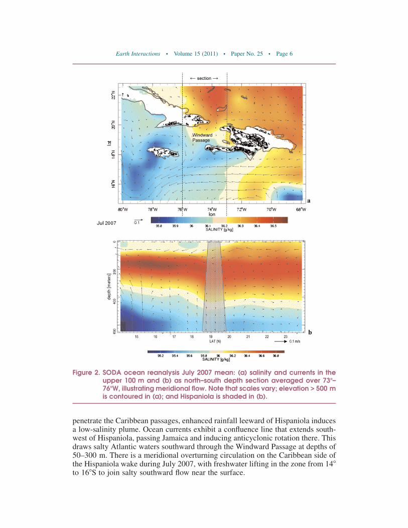
penetrate the Caribbean passages, enhanced rainfall leeward of Hispaniola inducesa low-salinity plume. Ocean currents exhibit a confluence line that extends south-west of Hispaniola, passing Jamaica and inducing anticyclonic rotation there. Thisdraws salty Atlantic waters southward through the Windward Passage at depths of50–300 m. There is a meridional overturning circulation on the Caribbean side ofthe Hispaniola wake during July 2007, with freshwater lifting in the zone from 148to 168S to join salty southward flow near the surface.
Figure 2. SODA ocean reanalysis July 2007 mean: (a) salinity and currents in theupper 100 m and (b) as north–south depth section averaged over 738–768W, illustrating meridional flow. Note that scales vary; elevation > 500 mis contoured in (a); and Hispaniola is shaded in (b).
Earth Interactions d Volume 15 (2011) d Paper No. 25 d Page 6
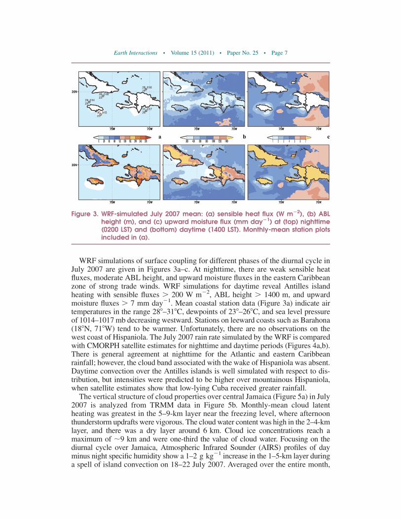
WRF simulations of surface coupling for different phases of the diurnal cycle inJuly 2007 are given in Figures 3a–c. At nighttime, there are weak sensible heatfluxes, moderate ABL height, and upward moisture fluxes in the eastern Caribbeanzone of strong trade winds. WRF simulations for daytime reveal Antilles islandheating with sensible fluxes . 200 W m22, ABL height . 1400 m, and upwardmoisture fluxes . 7 mm day21. Mean coastal station data (Figure 3a) indicate airtemperatures in the range 288–318C, dewpoints of 238–268C, and sea level pressureof 1014–1017 mb decreasing westward. Stations on leeward coasts such as Barahona(188N, 718W) tend to be warmer. Unfortunately, there are no observations on thewest coast of Hispaniola. The July 2007 rain rate simulated by the WRF is comparedwith CMORPH satellite estimates for nighttime and daytime periods (Figures 4a,b).There is general agreement at nighttime for the Atlantic and eastern Caribbeanrainfall; however, the cloud band associated with the wake of Hispaniola was absent.Daytime convection over the Antilles islands is well simulated with respect to dis-tribution, but intensities were predicted to be higher over mountainous Hispaniola,when satellite estimates show that low-lying Cuba received greater rainfall.
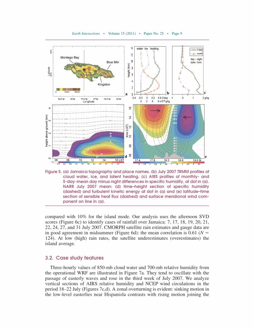
The vertical structure of cloud properties over central Jamaica (Figure 5a) in July2007 is analyzed from TRMM data in Figure 5b. Monthly-mean cloud latentheating was greatest in the 5–9-km layer near the freezing level, where afternoonthunderstorm updrafts were vigorous. The cloud water content was high in the 2–4-kmlayer, and there was a dry layer around 6 km. Cloud ice concentrations reach amaximum of ;9 km and were one-third the value of cloud water. Focusing on thediurnal cycle over Jamaica, Atmospheric Infrared Sounder (AIRS) profiles of dayminus night specific humidity show a 1–2 g kg21 increase in the 1–5-km layer duringa spell of island convection on 18–22 July 2007. Averaged over the entire month,
Figure 3. WRF-simulated July 2007 mean: (a) sensible heat flux (W m22), (b) ABLheight (m), and (c) upward moisture flux (mm day21) at (top) nighttime(0200 LST) and (bottom) daytime (1400 LST). Monthly-mean station plotsincluded in (a).
Earth Interactions d Volume 15 (2011) d Paper No. 25 d Page 7

however, daytime values were only 0.5 g kg21 higher in the ABL. We analyze NARRdata from 0500 to 1700 LST averaged for July 2007. The time–height section ofspecific humidity and turbulent kinetic energy (Figure 5d) reveals ABL growth to2000 m by 1400 LST, consistent with Schafer et al. (Schafer et al. 2001) and Jury et al.(Jury et al. 2009). Sensible heat flux peaks then (Figure 5e), and surface meridionalwinds converge onto the island with southerly components over the south coast of4 m s21 by 1700 LST. This indicates the 32-km Eta model assimilation is capable ofrepresenting sea-breeze confluence and mountain wakes over Jamaica, similar toBaik (Baik 1992). Although the NARR dry bias inflates daytime sensible fluxesabove WRF estimates, its confluent wind circulations are close to observed values.
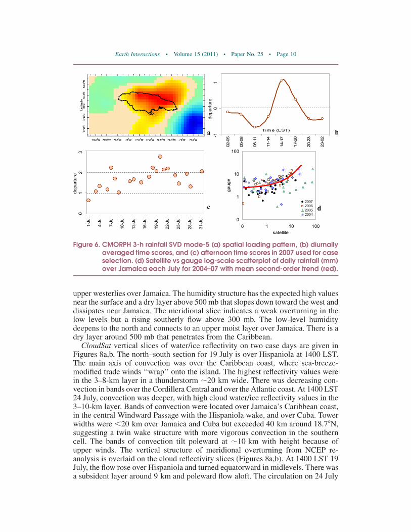
Island-scale convection was studied by SVD for 3-h rainfall in 2007 (N 5 2920).The island mode that emerges over the northeastern interior (Figure 6a) has neg-ative loading over the sea with a northeast alignment to the Hispaniola wake. SVDscores averaged over the diurnal cycle (Figure 6b) reveal a peak during the af-ternoon at 1400–1700 LST, as found over Puerto Rico by Carter and Elsner (Carterand Elsner 1997) and Jury et al. (Jury et al. 2009). Marine convection contributedby passing troughs and waves tends to peak from 0200 to 0800 LST and has littlediurnal amplitude (not shown). The variance explained by the marine mode is 32%
Figure 4. July 2007 mean rain rate (mm day21): (a) WRF-simulated and (b) CMORPHsatellite estimate (top) at nighttime (0200–500 LST) and (bottom) at day-time (1400–1700 LST).
Earth Interactions d Volume 15 (2011) d Paper No. 25 d Page 8
compared with 10% for the island mode. Our analysis uses the afternoon SVDscores (Figure 6c) to identify cases of rainfall over Jamaica: 7, 17, 18, 19, 20, 21,22, 24, 27, and 31 July 2007. CMORPH satellite rain estimates and gauge data arein good agreement in midsummer (Figure 6d): the mean correlation is 0.61 (N 5124). At low (high) rain rates, the satellite underestimates (overestimates) theisland average.
3.2. Case study features
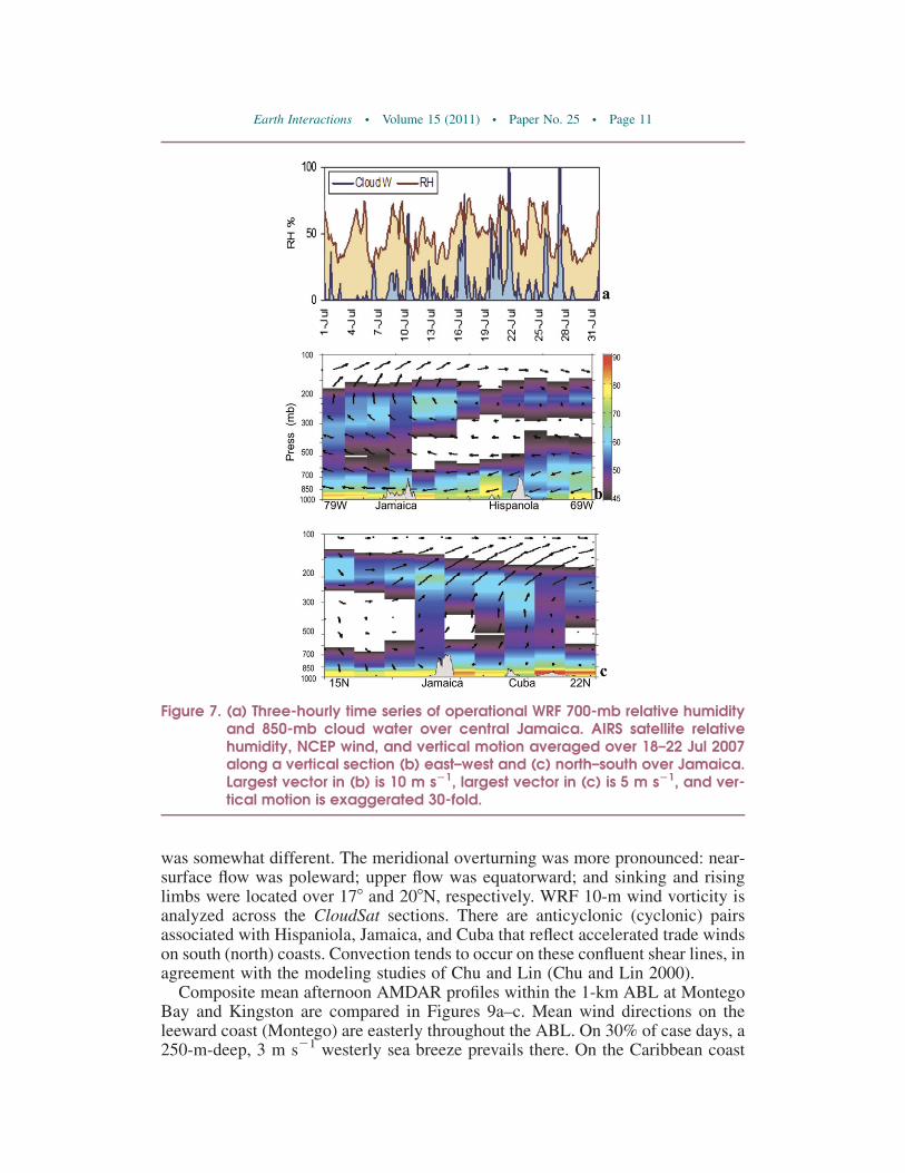
Three-hourly values of 850-mb cloud water and 700-mb relative humidity fromthe operational WRF are illustrated in Figure 7a. They tend to oscillate with thepassage of easterly waves and rose in the third week of July 2007. We analyzevertical sections of AIRS relative humidity and NCEP wind circulations in theperiod 18–22 July (Figures 7c,d). A zonal overturning is evident: sinking motion inthe low-level easterlies near Hispaniola contrasts with rising motion joining the
Figure 5. (a) Jamaica topography and place names. (b) July 2007 TRMM profiles ofcloud water, ice, and latent heating. (c) AIRS profiles of monthly- and5-day-mean day minus night differences in specific humidity, at dot in (a).NARR July 2007 mean: (d) time–height section of specific humidity(dashed) and turbulent kinetic energy at dot in (a) and (e) latitude–timesection of sensible heat flux (dashed) and surface meridional wind com-ponent on line in (a).
Earth Interactions d Volume 15 (2011) d Paper No. 25 d Page 9
upper westerlies over Jamaica. The humidity structure has the expected high valuesnear the surface and a dry layer above 500 mb that slopes down toward the west anddissipates near Jamaica. The meridional slice indicates a weak overturning in thelow levels but a rising southerly flow above 300 mb. The low-level humiditydeepens to the north and connects to an upper moist layer over Jamaica. There is adry layer around 500 mb that penetrates from the Caribbean.
CloudSat vertical slices of water/ice reflectivity on two case days are given inFigures 8a,b. The north–south section for 19 July is over Hispaniola at 1400 LST.The main axis of convection was over the Caribbean coast, where sea-breeze-modified trade winds ‘‘wrap’’ onto the island. The highest reflectivity values werein the 3–8-km layer in a thunderstorm ;20 km wide. There was decreasing con-vection in bands over the Cordillera Central and over the Atlantic coast. At 1400 LST24 July, convection was deeper, with high cloud water/ice reflectivity values in the3–10-km layer. Bands of convection were located over Jamaica’s Caribbean coast,in the central Windward Passage with the Hispaniola wake, and over Cuba. Towerwidths were ,20 km over Jamaica and Cuba but exceeded 40 km around 18.78N,suggesting a twin wake structure with more vigorous convection in the southerncell. The bands of convection tilt poleward at ;10 km with height because ofupper winds. The vertical structure of meridional overturning from NCEP re-analysis is overlaid on the cloud reflectivity slices (Figures 8a,b). At 1400 LST 19July, the flow rose over Hispaniola and turned equatorward in midlevels. There wasa subsident layer around 9 km and poleward flow aloft. The circulation on 24 July
Figure 6. CMORPH 3-h rainfall SVD mode-5 (a) spatial loading pattern, (b) diurnallyaveraged time scores, and (c) afternoon time scores in 2007 used for caseselection. (d) Satellite vs gauge log-scale scatterplot of daily rainfall (mm)over Jamaica each July for 2004–07 with mean second-order trend (red).
Earth Interactions d Volume 15 (2011) d Paper No. 25 d Page 10
was somewhat different. The meridional overturning was more pronounced: near-surface flow was poleward; upper flow was equatorward; and sinking and risinglimbs were located over 178 and 208N, respectively. WRF 10-m wind vorticity isanalyzed across the CloudSat sections. There are anticyclonic (cyclonic) pairsassociated with Hispaniola, Jamaica, and Cuba that reflect accelerated trade windson south (north) coasts. Convection tends to occur on these confluent shear lines, inagreement with the modeling studies of Chu and Lin (Chu and Lin 2000).
Composite mean afternoon AMDAR profiles within the 1-km ABL at MontegoBay and Kingston are compared in Figures 9a–c. Mean wind directions on theleeward coast (Montego) are easterly throughout the ABL. On 30% of case days, a250-m-deep, 3 m s21 westerly sea breeze prevails there. On the Caribbean coast
Figure 7. (a) Three-hourly time series of operational WRF 700-mb relative humidityand 850-mb cloud water over central Jamaica. AIRS satellite relativehumidity, NCEP wind, and vertical motion averaged over 18–22 Jul 2007along a vertical section (b) east–west and (c) north–south over Jamaica.Largest vector in (b) is 10 m s21, largest vector in (c) is 5 m s21, and ver-tical motion is exaggerated 30-fold.
Earth Interactions d Volume 15 (2011) d Paper No. 25 d Page 11
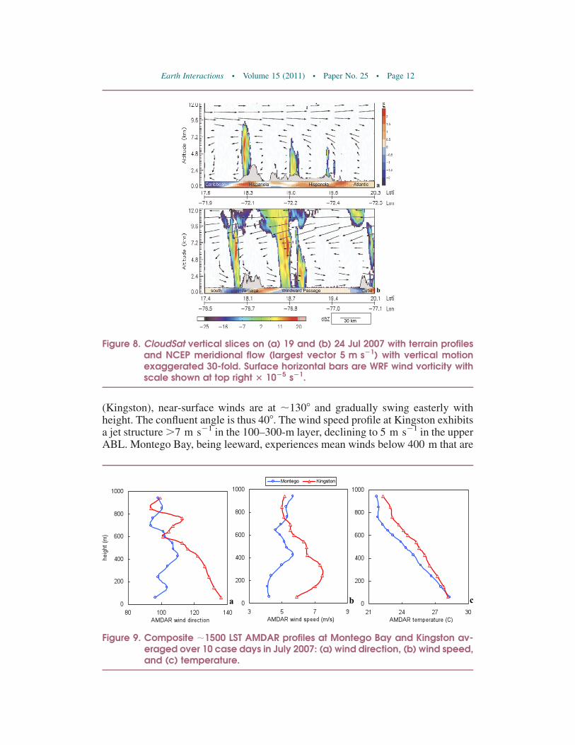
(Kingston), near-surface winds are at ;1308 and gradually swing easterly withheight. The confluent angle is thus 408. The wind speed profile at Kingston exhibitsa jet structure .7 m s21 in the 100–300-m layer, declining to 5 m s21 in the upperABL. Montego Bay, being leeward, experiences mean winds below 400 m that are
Figure 8. CloudSat vertical slices on (a) 19 and (b) 24 Jul 2007 with terrain profilesand NCEP meridional flow (largest vector 5 m s21) with vertical motionexaggerated 30-fold. Surface horizontal bars are WRF wind vorticity withscale shown at top right 3 1025 s21.
Figure 9. Composite ;1500 LST AMDAR profiles at Montego Bay and Kingston av-eraged over 10 case days in July 2007: (a) wind direction, (b) wind speed,and (c) temperature.
Earth Interactions d Volume 15 (2011) d Paper No. 25 d Page 12
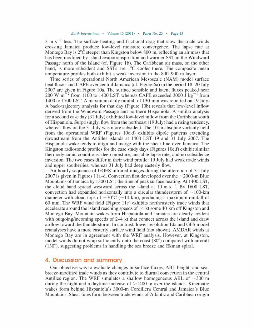
3 m s21 less. The surface heating and frictional drag that slow the trade windscrossing Jamaica produce low-level moisture convergence. The lapse rate atMontego Bay is 28C steeper than Kingston below 800 m, reflecting an air mass thathas been modified by island evapotranspiration and warmer SST in the WindwardPassage north of the island (cf. Figure 1b). The Caribbean air mass, on the otherhand, is more subsident and SSTs are 18C cooler there. The composite meantemperature profiles both exhibit a weak inversion in the 800–900-m layer.
Time series of operational North American Mesoscale (NAM) model surfaceheat fluxes and CAPE over central Jamaica (cf. Figure 6a) in the period 18–20 July2007 are given in Figure 10a. The surface sensible and latent fluxes peaked near200 W m22 from 1100 to 1400 LST, whereas CAPE exceeded 3000 J kg21 from1400 to 1700 LST. A maximum daily rainfall of 130 mm was reported on 19 July.A back-trajectory analysis for that day (Figure 10b) reveals that low-level inflowderived from the Windward Passage and northern Hispaniola. A similar analysisfor a second case day (31 July) exhibited low-level inflow from the Caribbean southof Hispaniola. Surprisingly, flow from the northeast (19 July) had a rising tendency,whereas flow on the 31 July was more subsident. The 10-m absolute vorticity fieldfrom the operational WRF (Figures 10c,d) exhibits dipole patterns extendingdownstream from the Antilles islands at 1400 LST 19 and 31 July 2007. TheHispaniola wake tends to align and merge with the shear line over Jamaica. TheKingston radiosonde profiles for the case study days (Figures 10e,f) exhibit similarthermodynamic conditions: deep moisture, unstable lapse rate, and no subsidenceinversion. The two cases differ in their wind profile: 19 July had weak trade windsand upper southerlies, whereas 31 July had deep easterly flow.
An hourly sequence of GOES infrared images during the afternoon of 31 July2007 is given in Figures 11a–d. Convection first developed over the ;2000-m BlueMountains of Jamaica by 1300 LST, the time of peak surface heating. At 1400 LST,the cloud band spread westward across the island at 10 m s21. By 1600 LST,convection had expanded horizontally into a circular thunderstorm of ;100-kmdiameter with cloud tops of 2708C (;14 km), producing a maximum rainfall of60 mm. The WRF wind field (Figure 11e) exhibits northeasterly trade winds thataccelerate around the island reaching speeds of 14 kt some 40 km off Kingston andMontego Bay. Mountain wakes from Hispaniola and Jamaica are clearly evidentwith outgoing/incoming speeds of 2–4 kt that connect across the island and drawairflow toward the thunderstorm. In contrast, lower-resolution Eta and GFS modelreanalyses have a more easterly surface wind field (not shown). AMDAR winds atMontego Bay are in agreement with the WRF analysis. However, at Kingston,model winds do not wrap sufficiently onto the coast (808) compared with aircraft(1308), suggesting problems in handling the sea breeze and Ekman spiral.
4. Discussion and summaryOur objective was to evaluate changes in surface fluxes, ABL height, and sea-
breeze-modified trade winds as they contribute to diurnal convection in the centralAntilles region. The WRF simulates a shallow homogeneous ABL of ;300 mduring the night and a daytime increase of .1400 m over the islands. Kinematicwakes form behind Hispaniola’s 3000-m Cordillera Central and Jamaica’s BlueMountains. Shear lines form between trade winds of Atlantic and Caribbean origin
Earth Interactions d Volume 15 (2011) d Paper No. 25 d Page 13

Figure 10. (a) Operational WRF-assimilated meteogram for central Jamaica 18–20Jul 2007 when island convection prevailed. (b) Hybrid Single-ParticleLagrangian Integrated Trajectories (HYSPLIT) model GFS ensemble backtrajectories for 24-h periods ending 1700 LST 19 and 31 Jul 2007, withvertical section lower. WRF 10-m absolute vorticity at 1400 LST on (c) 19and (d) 31 Jul 2007. Dashed line is island wake. (e),(f) Kingston radio-sonde profiles for same days. The 100-m AMDAR reports are included in(c).
Earth Interactions d Volume 15 (2011) d Paper No. 25 d Page 14
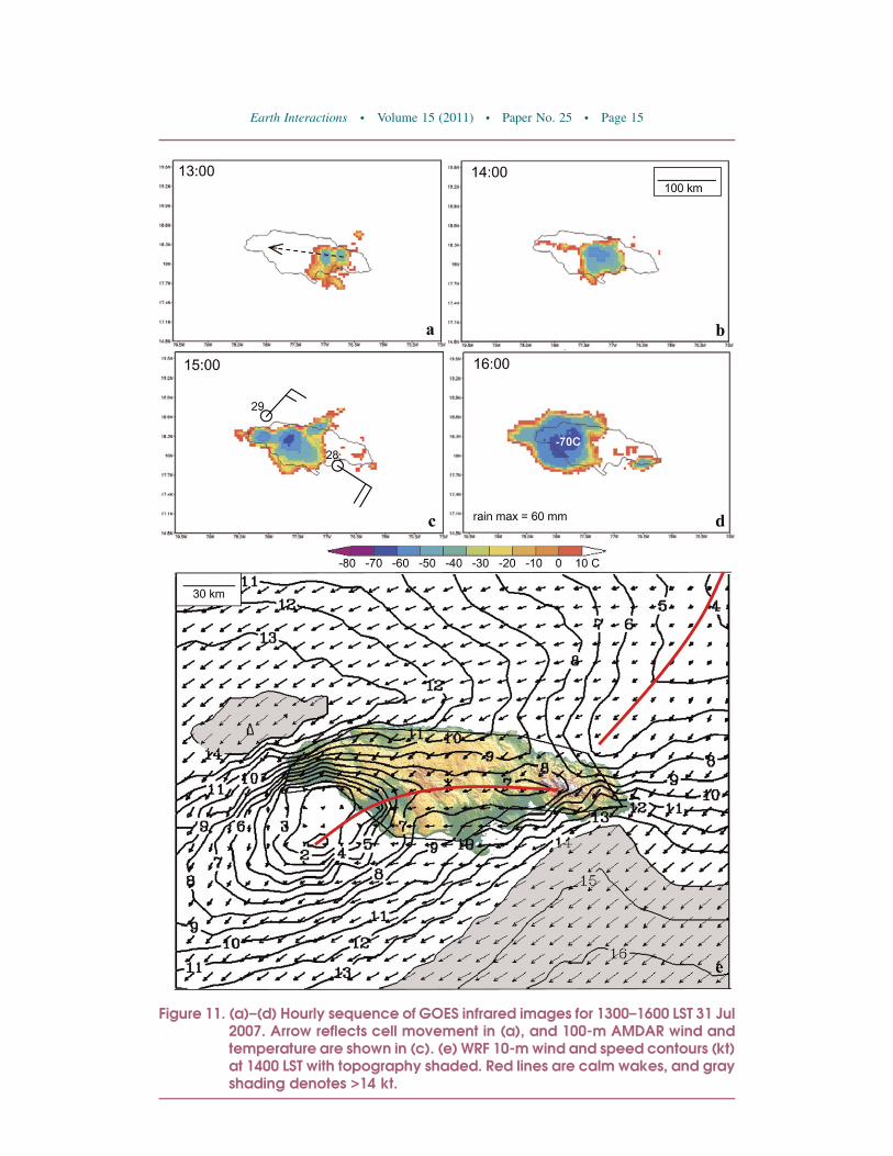
Figure 11. (a)–(d) Hourly sequence of GOES infrared images for 1300–1600 LST 31 Jul2007. Arrow reflects cell movement in (a), and 100-m AMDAR wind andtemperature are shown in (c). (e) WRF 10-m wind and speed contours (kt)at 1400 LST with topography shaded. Red lines are calm wakes, and grayshading denotes >14 kt.
Earth Interactions d Volume 15 (2011) d Paper No. 25 d Page 15
and SSTs exceed 308C west of Hispaniola. Daytime heating turns the trade winds208–308 onshore along the north and south coasts, so moist unstable air convergesover the western half of the islands during afternoon. Rain shadow zones developalong the southern flank of the islands of Hispaniola and Jamaica (cf. Figure 4;Gamble and Curtis 2008). Topographic flow interactions are characterized by aFroude number ,1, so Antilles mountain wakes extend downstream as in theHawaiian Islands (Burk et al. 2002) but with a weaker inversion above the ABL.The wind confluence lines are enriched by evapotranspiration fluxes during theafternoon, so CAPE rises above 3000 J kg21. The direction of flow is critical:easterly winds provide the longest over-island fetch. Surface heat fluxes estimatedby the WRF reach 300 W m22 over Jamaica, but no direct observations are availablefor comparison.
The upper ocean fields clearly reflect a wake from Hispaniola, with lowersalinity and confluent westward currents. This zone experiences significant di-urnal heating, so SSTs there rise above 308C in an axis that extends westward tothe south of Cuba, forming the leading edge of the ‘‘warm pool.’’ Because of saltypoleward flow through the Windward Passage, the oceanic wake deviates south ofJamaica, producing a large anticyclonic rotor there in July 2007. In the Caribbeansector, there is upward vertical motion that joins poleward currents near thesurface.
The climate of the central Antilles was studied using existing data and model-analyzed fields, with a focus on the diurnal cycle and its mesoscale features inmidsummer trade wind conditions. Daytime surface heating creates a thermal lowover the western plains of the central Antilles islands. NARR fields for July 2007exhibit air temperatures up to 378C over western Hispaniola and a thermal low of1015.5 mb. A landward pressure gradient of 2 mb (100 km)21 causes an infoldingof trade winds from the north and south coasts. By early afternoon, confluent shearlines develop over the islands of Hispaniola and Jamaica. The summer air mass ismoist, dewpoint temperature Td ;248C, and unstable, T ;308C, and afternoonthunderstorms form along the shear lines and drift westward bringing rainfall;10 mm h21. By sunset, the thunderstorms collapse and thermal lows weaken,allowing trade winds to resume. During the night, radiatively cooled air drains fromthe mountains and joins the trade winds, enhancing marine convection.
This study has described variations of the ABL across the central Antilles basedon limited in situ data, mesoscale reanalysis, and model simulations. The ability ofthe WRF to generate wind confluence, ABL response to surface heating, andconvective rainfall were evaluated with a view to improved short-range weatherforecasting. The model simulated the development of afternoon thunderstormsover the islands but did not maintain nocturnal convection in the Hispaniola wake.Further idealized WRF experiments may help distinguish the kinematic andthermodynamic effects. Although some verification data from an expanding net-work of automatic weather stations is anticipated, information on the verticalstructure of circulations is limited. In that regard, aerial surveys, flux towers, andDoppler weather radar would aid our understanding. Then model sensitivity studiescould better isolate the influences of sea breeze, orography, and evapotranspiration.
Acknowledgments. We acknowledge the data suppliers (http://ingrid.ldgo.columbia.edu;http://nomads.ncdc.noaa.gov/; http://disc.sci.gsfc.nasa.gov/giovanni; http://ready.arl.noaa.gov;
Earth Interactions d Volume 15 (2011) d Paper No. 25 d Page 16

http://amdar.noaa.gov; http://weather.uwyo.edu/upperair/). L. Brown of the Jamaican NMSkindly provided rain gauge data. Computations were performed at the National Center forAtmospheric Research. The second author is supported by the National Science Foun-dation Grant AGS-0855286.
References
Amador, J. A., 1998: A climatic feature of the tropical Americas: The trade wind easterly jet.Topicos Meteorologicos Oceanograficos, 5, 1–13.
Baik, J. J., 1992: Response of a stably stratified atmosphere to low-level heating: An application tothe heat island problem. J. Appl. Meteor., 31, 291–303.
Bao, J.-W., S. A. Michelson, P. O. G. Persson, I. V. Djalalova, and J. M. Wilczak, 2008: Observedand WRF-simulated low-level winds in a high-ozone episode during the Central CaliforniaOzone Study. J. Appl. Meteor. Climatol., 47, 2372–2394.
Blanchard, D. O., and R. E. Lopez, 1985: Spatial patterns of convection in south Florida. Mon. Wea.Rev., 113, 1282–1299.
Burk, S. D., T. Haack, L. T. Rogers, and L. J. Wagner, 2002: Island wake dynamics and wakeinfluence on the evaporation duct and radar propagation. J. Appl. Meteor., 42, 349–367.
Carbone, R. E., J. W. Wilson, T. D. Keenan, and J. M. Hacker, 2000: Tropical island convection inthe absence of significant topography. Part I: Life cycle of diurnally forced convection. Mon.Wea. Rev., 128, 3459–3480.
Carter, M. M., and J. B. Elsner, 1997: A statistical method for forecasting rainfall over Puerto Rico.Wea. Forecasting, 12, 515–525.
Carton, J. A., and B. S. Giese, 2008: A reanalysis of ocean climate using Simple Ocean DataAssimilation (SODA). Mon. Wea. Rev., 136, 2999–3017.
Chang, P., and R. Saravanan, 2001: A hybrid coupled model study of tropical Atlantic variability.J. Climate, 14, 361–390.
Chen, A. A., and M. Taylor, 2002: Investigating the link between early season Caribbean rainfalland the El Nino 1 1 year. Int. J. Climatol., 22, 87–106.
Chen, G. T.-J., and C.-C. Yu, 1988: Study of low-level jet and extremely heavy rainfall overnorthern Taiwan in the mei-yu season. Mon. Wea. Rev., 116, 884–891.
Chiao, S., 2006: Performance of planetary boundary layer schemes in the WRF model. Proc. 25thArmy Science Conf., Orlando, FL, U.S. Army, XX–XX.
Chopra, K. P., 1973: Atmospheric and oceanic flow problems introduced by islands. Advances inGeophysics, Vol. 16, Academic Press, 298–416.
Chu, C.-M., and Y.-L. Lin, 2000: Effects of orography on the generation and propagation ofmesoscale convective systems in a two-dimensional conditionally unstable flow. J. Atmos.Sci., 57, 3817–3837.
Cooper, H., M. Garstang, and J. Simpson, 1982: The diurnal interaction between convection andpeninsular-scale forcing over south Florida. Mon. Wea. Rev., 110, 486–503.
Curtis, S., and D. W. Gamble, 2008: Regional variations of the Caribbean mid-summer drought.Theor. Appl. Climatol., 94, 25–34.
De Haan, L. L., M. Kanamitsu, C. H. Lu, and J. O. Roads, 2007: A comparison of the Noahand OSU land surface models in the ECPC seasonal forecast model. J. Hydrometeor., 8,1031–1048.
Ek, M. B., K. E. Mitchell, Y. Lin, R. Rogers, P. Grunmann, V. Koren, G. Gayno, and J. D. Tarpley,2003: Implementation of Noah land surface model advances in the National Centers forEnvironmental Prediction operational mesoscale ETA model. J. Geophys. Res., 108, 8851,doi:10.1029/2002JD003296.
Enfield, D. B., and E. J. Alfaro, 1999: The dependence of Caribbean rainfall on the interaction ofthe tropical Atlantic and Pacific Oceans. J. Climate, 12, 2093–2103.
Earth Interactions d Volume 15 (2011) d Paper No. 25 d Page 17

Etling, D., 1989: On atmospheric vortex streets in the wake of large islands. Meteor. Atmos. Phys.,41, 157–164.
Gamble, D. W., and S. Curtis, 2008: Caribbean precipitation: Review, model, and prospect. Prog.Phys. Geogr., 23, 265–276.
——, D. Campbell, T. Allen, D. Barker, S. Curtis, D. McGregor, and J. Popke, 2010: Climatechange, drought, and Jamaican agriculture: Local knowledge and the climate record. Ann.Assoc. Amer. Geogr., 100, 880–893.
Giannini, A., Y. Kushnir, and M. A. Cane, 2000: Interannual variability of Caribbean rainfall,ENSO, and the Atlantic Ocean. J. Climate, 13, 297–311.
Grubisic, V., R. B. Smith, and C. Schar, 1995: The effect of bottom friction on shallow-water flowpast an isolated obstacle. J. Atmos. Sci., 52, 1985–2005.
Hong, S.-Y., and J. Dudhia, 2003: Testing of a non-local boundary layer vertical diffusion scheme innumerical weather prediction applications. Preprints, 20th Conf. Weather Analysis andForecasting, Seattle, WA, Amer. Meteor. Soc., 17.3. [Available online at http://ams.confex.com/ams/pdfpapers/72744.pdf.]
Joyce, R. J., J. E. Janowiak, P. A. Arkin, and P. Xie, 2004: CMORPH: A method that producesglobal precipitation estimates from passive microwave and infrared data at high spatial andtemporal resolution. J. Hydrometeor., 5, 487–503.
Jury, M. R., 2009: An intercomparison of observational, reanalysis, satellite, and coupled modeldata on mean rainfall in the Caribbean. J. Hydrometeor., 10, 413–430.
——, B. A. Malmgren, and A. Winter, 2007: Sub-regional precipitation climate of the Caribbean andrelationships with ENSO and NAO. J. Geophys. Res., 112, D16107, doi:10.1029/2006JD007541.
——, S. Chiao, and E. W. Harmsen, 2009: Mesoscale structure of trade wind convection over PuertoRico, composite observations and numerical model simulation. Bound.-Layer Meteor., 132,289–313.
Keenan, T. D., and Coauthors, 2000: The Maritime Continent Thunderstorm Experiment(MCTEX): Overview and results. Bull. Amer. Meteor. Soc., 81, 2433–2455.
Kingsmill, D. E., 1995: Convection initiation associated with a sea-breeze front, a gust front, andtheir interaction. Mon. Wea. Rev., 123, 2913–2933.
Laing, A. G., 2004: Cases of heavy precipitation and flash floods in the Caribbean during El Ninowinters. J. Hydrometeor., 5, 577–594.
Liu, C., and M. W. Moncrieff, 1996: A numerical study of the effects of ambient flow and shear ondensity currents. Mon. Wea. Rev., 124, 2282–2303.
Malkus, J. S., 1954: Some results of a trade cumulus cloud investigation. J. Meteor., 11, 220–237.——, 1955: The effects of a large island upon the trade-wind air stream. Quart. J. Roy. Meteor. Soc.,
81, 538–550.Mesinger, F., and Coauthors, 2006: North American Regional Reanalysis. Bull. Amer. Meteor. Soc.,
87, 343–360.Mitchell, K. E., and Coauthors, 2002: The community Noah land surface model (LSM) user’s
guide. NOAA Rep.Mlawer, E. J., S. J. Taubman, P. D. Brown, M. J. Iacono, and S. A. Clough, 1997: Radiative transfer
for inhomogeneous atmosphere: RRTM, a validated correlated-k model for the long-wave.J. Geophys. Res., 102 (D14), 16 663–16 682.
Munoz, E., A. J. Busalacchi, S. Nigam, and A. Ruiz-Barradas, 2008: Winter and summer structureof the Caribbean low-level jet. J. Climate, 21, 1260–1276.
Pagowski, M., J. Hacker, J. W. Bao, 2005: Behaviour of WRF PBL schemes and land-surfacemodels in 1-D simulation during BAMEX. Proc. WRF Users Workshop, Boulder, CO, Na-tional Center for Atmospheric Research, 27–30.
Rogers, E., M. Ek, Y. Lin, K. Mitchell, D. Parrish, and G. DiMego, 2001: Changes to the NCEPMeso ETA analysis and forecast system: Assimilation of observed precipitation, land-surfacephysics, modified 3-D VAR analysis. NOAA Rep. [Available online at http://www.emc.ncep.noaa.gov/mmb/mmbpll/spring2001/tpb/.]
Earth Interactions d Volume 15 (2011) d Paper No. 25 d Page 18

Schafer, R., P. T. May, T. D. Keenan, K. McGuffie, W. L. Ecklund, P. E. Johnston, and K. S. Gage,2001: Boundary layer development over a tropical island during the Maritime ContinentThunderstorm Experiment. J. Atmos. Sci., 58, 2163–2179.
Schar, C., and R. B. Smith, 1993a: Shallow-water flow past isolated topography. Part I: Vorticityproduction and wake formation. J. Atmos. Sci., 50, 1373–1400.
——, and ——, 1993b: Shallow-water flow past isolated topography. Part II: Transition to vortexshedding. J. Atmos. Sci., 50, 1401–1412.
Small, R. J. O., S. P. de Szoeke, and S. P. Xie, 2007: The Central American mid-summer drought:Regional aspects and large-scale forcing. J. Climate, 20, 4853–4873.
Smith, R. B., and V. Grubisic, 1993: Aerial observations of Hawaii’s wake. J. Atmos. Sci., 50, 3728–3750.——, A. C. Gleason, P. A. Gluhosky, and V. Grubisic, 1997: The wake of St. Vincent. J. Atmos. Sci.,
54, 606–623.Wakimoto, R. M., and N. T. Atkins, 1994: Observations of the sea-breeze front during CaPE. Part I:
Single-Doppler, satellite, and cloud photogrammetry analysis. Mon. Wea. Rev., 122, 1092–1114.Wilson, J. W., and W. E. Schreiber, 1986: Initiation of convective storms at radar-observed
boundary-layer convergence lines. Mon. Wea. Rev., 114, 2516–2536.
Earth Interactions is published jointly by the American Meteorological Society, the American Geophysical
Union, and the Association of American Geographers. Permission to use figures, tables, and brief excerpts
from this journal in scientific and educational works is hereby granted provided that the source is
acknowledged. Any use of material in this journal that is determined to be ‘‘fair use’’ under Section 107 or that
satisfies the conditions specified in Section 108 of the U.S. Copyright Law (17 USC, as revised by P.IL. 94-
553) does not require the publishers’ permission. For permission for any other from of copying, contact one of
the copublishing societies.
Earth Interactions d Volume 15 (2011) d Paper No. 25 d Page 19