Marine Issues and JCOMM matters - WMO
22
Marine Issues and JCOMM matters Dr Jean-Louis Fellous (based on contributions from B. Lee, D. Halpern and J.L. Fellous) ET-SUP-7 1 Geneva, 27-30 May 2013
Transcript of Marine Issues and JCOMM matters - WMO

Marine Issues and JCOMM matters
Dr Jean-Louis Fellous(based on contributions from B. Lee, D. Halpern and
J.L. Fellous)
ET-SUP-7 1Geneva, 27-30 May 2013

Introduction
• Satellite observations have clearly demonstrated usefulness in providing information for ocean applications, operational and research-based, to improve simulation and forecasting of ocean states, and more recently for coastal applications.
• This report introduces some applications of satellite data/products in ocean and coastal applications, and related issues.
ET-SUP-7 2Geneva, 27-30 May 2013
Sources of Met-Ocean Data
ET-SUP-7 Geneva, 27-30 May 2013 3
Parameter Field data sources Satellite data sources Numerical model and analysis data sources
Sea state
Wave buoys.Ship observations.Oil platforms.Coastal HF radar.
Satellite altimetry (wave height data).Synthetic Aperture Radar data.
Wave model analysis and forecast systems
Surface wind
Moored buoys.Drifting buoys. Ship observations.Oil platforms.
Scatterometer data.Satellite altimetry.
NWP analysis and forecast systems.
Precipitation
Ship observations.Coastal stations.Oil platforms.Weather radar.
Rain radar.Infrared radiometers
NWP analysis and forecast systems.
Sea surface temperature
Argo floats.Ship observations.Moored buoys.Drifting buoys.
Infrared satellite data.Microwave satellite data.
SST analysis systems. Ocean analysis and forecast systems.
Currents Current metersDrifting buoys Satellite altimetry Global ocean circulation models
Bathymetry / shoreline Aerial photographs. Satellite imagery. Bathymetric chart data.Gridded bathymetric datasets.
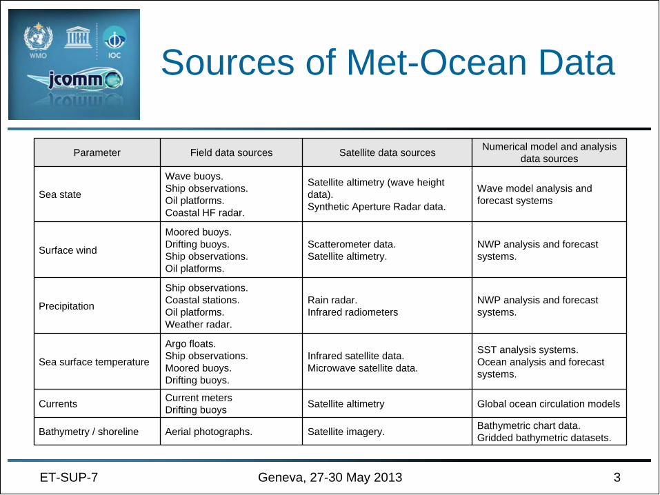
Sea Surface Temperature
• Sea Surface Temperature (SST) is one of the variables essential to monitoring and simulating ocean state, and to correctly determine the heat and momentum fluxes across the air-sea interface.
• The amount of SST data has increased dramatically thanks to satellite measurements.
ET-SUP-7 Geneva, 27-30 May 2013 4
Global daily SST analysis from the Operational Sea Surface Temperature and Sea Ice Analysis
Project(OSTIA) product (PODAAC), blending AVHRR, AATSR, AMSR-E and TMI

GRHSST
ET-SUP-7 Geneva, 27-30 May 2013 5
• The Group on High Resolution SST (GHRSST) has provided operational users and science community with SST measured by the satellite constellation, a framework for SST data sharing, best practices for data processing and a forum for scientific dialogue, bringing SST to the user.– A variety of satellite SST data are available on GHRSST Global
and Regional Data Assembly Centers (GDAC/RDACs) in Australia, Japan, USA and Europe.
– Each RDAC provides its own satellite SST data in a common GHRSST format specification, which is a netCDF file

GHRSST, modeling & WMO
ET-SUP-7 Geneva, 27-30 May 2013 6
• The ocean modeling community is the key user of GHRSST (requirements origin from GODAE)
• GHRSST has been actively communicating with the JCOMM Expert Team on Operational Ocean Forecasting Systems (ETOOFS), and with scientific panels of GCOS and WMO to review and meet requirements for ocean modeling. In doing so, GHRSST has significantly contributed to WMO RRR/OSCAR.
SST Products
ET-SUP-7 Geneva, 27-30 May 2013 7
• A multi-satellite SST product has been produced by the UKMO through the MyOcean project, providing an estimate of the foundation SST (ocean temperature at a depth free of diurnal variations)– This product meets the needs of applications requiring high-
resolution space-time scales including global NWP and operational ocean models.
– It consists of daily gap-free maps of sea surface temperature, at 0.05° x 0.05° resolution using in situ and satellite observations.
• Other SST products include the NOAA AVHRR CLASS service and the JAXA AMSR-2 GCOM-W1 Data Providing Service

Issues and Challenges
• Some issues and future challenges discussed between GHRSST and ETOOFS include:– The loss of AATSR and
hence the need for a new reference dataset
– The loss of AMSR-E, possibly covered by new AMSR-2 SST products
– The need for SST data from GEO over the Indian Ocean
ET-SUP-7 Geneva, 27-30 May 2013 8
Examples of just-released products from AMSR-2from descending orbit
on May 8, 2013

Scatterometer Winds
ET-SUP-7 Geneva, 27-30 May 2013 9
• The scatterometer is a satellite instrument that provides global measurements of the wind speed and direction at the sea surface. There have been scatterometers in orbit since 1992.– Scatterometers were flown on ERS-1 and -2, then on QuikSCAT.– Currently three operational scatterometers are providing
worldwide data: the ASCAT on MetOp-A and -B, and OSCAT on the Indian Oceansat-2.
– Efforts are being made to make global winds from the Chinese scatterometer HY-2A globally available. KNMI is producing wind calibrated/validated products for all these scatterometers on behalf of the EUMETSAT OSI-SAF.

Scatterometer Wind Applications
• Scatterometer wind data are important sources of information for NWP, oceanography and climate.
• They also provide key information for hindcast studies of past storms, and for assimilation in wave and storm surge forecast models, as well as for nowcasting.
ET-SUP-7 Geneva, 27-30 May 2013 10
Swirling winds at the center of Hurricane Sandy on Oct. 29 from
ASCAT on MetOp-B
Issues and Challenges
ET-SUP-7 Geneva, 27-30 May 2013 11
• The loss of QuikSCAT significantly reduced forecasters’ ability to observe extreme winds. However, international partnerships between NOAA and EUMETSAT (MetOp- A,B,C ASCAT) and most recently ISRO (Indian Space Research Organization, OceanSat-2, OSCAT) have significantly mitigated the loss of QuikSCAT.
• The use of OSI-SAF products is granted to every interested user, free of charge, preserving property rights of EUMETSAT. However, the Near Real-Time (NRT) OSCAT data can only be used by European, non- commercial users.

Prospects
ET-SUP-7 Geneva, 27-30 May 2013 12
• A recently emerging requirement is on a coordinated development/extension of integrated satellite and in situ Ocean Surface Vector Winds (OSVW), and its application for marine forecasts, similar to GHRSST products for SST.
• Regarding a related effort for capacity development, since November 2009, NOAA, EUMETSAT, NASA and IOC/IODE have jointly conducted several training sessions on applications of satellite ocean surface vector winds for operational marine forecasting, in collaboration with JCOMM capacity building efforts.

Open-Ocean Altimetry
ET-SUP-7 Geneva, 27-30 May 2013 13
• Satellite altimetry provides accurate measurements of sea surface topography, through the analysis of radar echoes that provides sea surface height (SSH), significant wave height and surface wind speed.– SSH data products provide the primary information for ocean
models to retrieve ocean circulation through data assimilation.– Current missions include Jason-1 and -2, CryoSat-2, Saral and
HY-2A, to be followed/added by Sentinel-3, Jason-3, Jason-CS and SWOT.
– The ocean modeling community relies on the expertise in the Ocean Surface Topography Science Team (OSTST) and space agencies to provide the best available products.

The CEOS Altimetry Constellation
ET-SUP-7 Geneva, 27-30 May 2013 14
• The impact of satellite altimetry on ocean modeling/forecasting has been demonstrated.– Four polar orbiting, narrow-swath altimeters (with at
least one in the reference high altitude orbit of Topex/Poseidon and Jason) are required for consistent sea surface height products in real-time.
– This has given rise to the concept of a satellite “virtual constellation” which requires the coordination of many international programs and is an on-going, multi- agency effort in the context of CEOS.
Coastal Altimetry
ET-SUP-7 Geneva, 27-30 May 2013 15
• Until recently, altimeter data near the coast were usually discarded as inaccurate or difficult to interpret.
• Through reprocessing of radar echoes and improving the corrections that need to be applied to altimetric signals, meaningful measurements can be retrieved in the coastal strip (approx. 0-50 km from the coast)
• Coastal altimetry can play a prominent role in storm surge and coastal inundation research, as it directly measures the total water level envelope, i.e. the sea level taking into account tides, waves, effects of a storm surge, precipitation and river flows.

Coastal Ocean Products
ET-SUP-7 Geneva, 27-30 May 2013 16
• Latest developments, e.g. the COASTALT study funded by ESA, and PISTACH funded by the French CNES, enabled to produce delayed-time coastal products from different altimetry missions (Envisat, Jason-1, Jason-2, and CryoSat-2) through the development of techniques/algorithms to recover useful measurements of sea level and significant wave height in coastal waters, and to implement and promote new applications.

Prospects
ET-SUP-7 Geneva, 27-30 May 2013 17
• In many areas with limited infrastructure, satellite observation may be the only feasible way to consistently measure met-ocean parameters. Such developments may enable integrating the altimeter measurements of sea level, wind speed and significant wave height into coastal ocean observing systems– Several parameters derived from altimetry, including wind speed
and wave height, mesoscale circulation, can contribute to forecasts of tropical cyclone paths and heat potential.
– Improvement of the re-tracking process of altimeter waveforms and optimized corrections of ocean tides, water vapor, and sea state bias are also needed.

Synthetic Aperture Radar
ET-SUP-7 Geneva, 27-30 May 2013 18
• SAR (Synthetic Aperture Radar) can measure wind speeds, both in the coastal zone and in the open ocean where no in situ measurements are possible.
• SARs operating at C-band like on Envisat, ERS-1 or ERS-2, offer the unique ability to provide continuous global directional information on wave field for various uses such as input to NWP as well as ocean wave climate tools.– Through the GlobWave project by ESA, wave mode products
correspond to small measurements called imagettes)which are approximately 5 km along-track by (up to) 10 km in across-track, acquired at 100 km (or 200 km for ERS) intervals.
Other Programs and Activities
ET-SUP-7 Geneva, 27-30 May 2013 19
• AVISO is a French-based data provider that serves both Europe and international groups with particular expertise in altimetry.
• The NASA PODAAC provides access to data and products restricted to those missions for which NASA is a partner.
• The RADS at TU Delft provides a harmonised, validated and cross- calibrated sea level data base from satellite altimeter data (compliant with OSTST standards).
• The ESA’s GlobWave project allows easy access to a uniform set of along-track satellite wave data from all available altimeters (spanning multiple space agencies) and from ESA SAR data.
• The ESA eSurge Project has developed the eSurge Event Analysis and Repository Service (SEARS) which contains a wide variety of satellite data for a range of storm surge events.

TT-SAT established
• As part of JCOMM Crosscutting activities a Task Team on Satellite Data Requirements (TT-SAT) was established at the 8th JCOMM Management Committee meeting (MAN-VIII) in November 2010.
• In September 2011, MAN-IX agreed that TT-SAT should focus its efforts on products and integration of in situ and satellite data to improve such products (e.g. cal/val, blended products).
• Noting that integrated in situ and satellite Ocean Surface Vector Winds (OSVW) products would substantially improve the operational applications (including those of NWP, sea state forecasting and warnings, and coastal applications) that provide socio-economical benefits, MAN-IX instructed the TT-SAT to set up a plan to establish a SVW group to function like the GHRSST, in close collaboration with the interested satellite and in situ communities.
ET-SUP-7 20Geneva, 27-30 May 2013

Toward an OSVWG?
ET-SUP-7 Geneva, 27-30 May 2013 21
• In May 2012, JCOMM-4 endorsed the MAN proposal for TT-SAT– On behalf of IOC, Dr David Halpern presented to CGMS-40 in
Lugano (November 2012) a forward-looking paper entitled “Ocean Surface Vector Wind: Research Challenges and Operational Opportunities” paving the way toward the “open and transparent generation of high-quality, user-friendly OSVW datasets”, to be made available “through the GTS, FTP, EUMETCast, the WIS and other means”.
– The TT-SAT has not yet delivered the requested plan. It was recently re-established, but did not meet ever since.
– The International Ocean Vector Wind Science Team met on May 5-8, but it did not receive any information from TT-SAT.

THANK YOU FOR YOUR ATTENTION!
ET-SUP-7 Geneva, 27-30 May 2013 22